


Abstract
Understanding how urban spatial structure evolves under environmental constraints is essential for sustainable urban development and planning practice. However, existing studies often analyze population distribution and urban functions separately, providing limited explanation of the mechanisms underlying urban spatial restructuring. This limitation is particularly evident in mountain cities, where topographic constraints, fragmented developable land, and corridor-based accessibility shape distinctive spatial patterns. Using Chongqing as a case study, this study examines the evolution of its central urban area between 2020 and 2024 from an integrated population–function perspective. Multi-temporal Baidu residential and employment population data and POI data are used to characterize population activities and urban functions. A functional reinterpretation framework is developed by aggregating conventional POI categories into three dimensions: prosperity, dynamism, and synergy. Kernel density estimation, density difference analysis, Getis–Ord Gi* hotspot analysis, and population–function relationship analysis are applied to examine spatial evolution and interaction patterns under topographic constraints. The results show that Chongqing experienced substantial spatial restructuring characterized by increasing polycentricity and internal reorganization rather than simple outward expansion. Residential and employment populations expanded along river valleys and development corridors, while employment activities remained more concentrated in established centers. Functional evolution shows clear differentiation: prosperity remains concentrated in traditional centers, dynamism expands toward emerging development platforms, and synergy diffuses through residential and transportation networks. Residential populations are more strongly associated with synergy functions, whereas employment populations are more closely linked to dynamism functions.
1. Introduction
Urban spatial structure has long been a central concern in urban geography and planning because it reflects the ways in which population, economic activities, and urban functions are organized in space. Early studies established the theoretical foundation of urban spatial structure by emphasizing the spatial organization of economic activities and the relationships among urban centers [1,2], while subsequent research further extended these ideas to regional urban systems and broader interpretations of spatial organization [3]. From the monocentric city model to polycentric urban region theory, most classical frameworks explain spatial structure as the outcome of agglomeration economies, accessibility advantages, and land-use competition [4,5]. Although these theories differ in their interpretations of urban growth, they share a common assumption: urban development takes place within relatively continuous and accessible space [6,7,8,9]. Under this assumption, population and functions are expected to expand outward from existing centers, gradually producing hierarchical spatial structures through processes of concentration, diffusion, and decentralization [10,11].
However, this assumption becomes increasingly problematic when applied to mountain cities. Recent mountain-city studies have demonstrated that topography fundamentally reshapes urban development processes by constraining land availability, transportation accessibility, and spatial continuity [12,13,14]. Unlike cities located on plains, mountain cities are characterized by fragmented developable land, strong topographic barriers, discontinuous transportation corridors, and highly constrained patterns of spatial expansion [15,16,17]. In such environments, urban growth does not simply follow distance-decay logic or concentric expansion [18]. Instead, population activities and urban functions are often concentrated within river valleys, distributed across separated urban clusters, and connected through corridor-based infrastructure systems [19]. Consequently, the mechanisms through which urban spatial structure evolves in mountain cities may differ fundamentally from those observed in flat-terrain cities [20]. Yet despite the global prevalence of mountain cities and their growing importance in rapidly urbanizing regions, the majority of urban spatial structure research continues to be derived from empirical observations of relatively unconstrained metropolitan areas [21]. As a result, the applicability of existing theories to mountain-city environments remains insufficiently examined [22].
At the same time, the emergence of geospatial big data has fundamentally transformed the empirical study of urban spatial structure. Recent advances in urban sensing technologies and computational urban science have enabled researchers to observe urban systems with unprecedented spatial and temporal resolution [23,24,25]. The increasing availability of location-based services, mobile positioning records, and point-of-interest (POI) datasets enables researchers to observe urban activities with unprecedented spatial and temporal resolution [26]. Compared with traditional census data and land-use surveys, these datasets provide more direct representations of population activities and functional distributions, allowing researchers to identify urban centers, detect spatial clusters, and analyze urban dynamics at much finer scales. This data revolution has significantly enhanced our ability to describe urban spatial patterns and has generated a large body of data-driven urban research.
Yet a paradox remains. While urban data have become increasingly detailed, the interpretation of urban spatial structure has not necessarily become more sophisticated. Many studies continue to analyze population distribution and functional distribution separately, producing increasingly accurate descriptions of where people are and where functions are located, but offering limited explanation of how these elements interact to produce urban spatial structure [27,28,29]. Recent research has also pointed out that data-driven urban studies increasingly emphasize pattern recognition and functional identification, whereas the mechanisms underlying urban spatial restructuring remain comparatively underexplored [30]. In other words, improvements in measurement have often outpaced improvements in interpretation. Urban spatial structure is not merely the coexistence of population and functions in the same space; rather, it emerges from the continuous interaction between them. Population concentration influences functional demand, while functional allocation shapes the attraction and redistribution of population activities [31,32]. Ignoring these interactions risks reducing urban spatial structure to a collection of spatial patterns rather than understanding it as an evolving urban system.
A second limitation concerns the way functional information is represented. Most existing studies classify POIs according to conventional land-use categories such as commercial, residential, industrial, educational, or transportation functions [33,34,35]. While such classifications are useful for describing urban composition, they often reveal little about the structural roles that different functions play within urban systems. For example, commercial facilities and tourism attractions may belong to different categories but jointly contribute to urban centrality and attraction. Likewise, educational institutions, medical services, and office facilities perform different functions but collectively sustain urban productivity and vitality. Residential communities and transportation facilities are also commonly analyzed separately despite their shared role in supporting urban operation and connectivity. As POI classifications become increasingly detailed, researchers often gain more information about functional categories while simultaneously losing the ability to explain broader structural processes. This creates a paradox of functional analysis: more categories do not necessarily lead to better understanding of urban spatial structure [36].
More fundamentally, these limitations reflect a deeper conceptual issue concerning the nature of urban spatial structure itself. In much of the existing literature, spatial structure is implicitly treated as a spatial outcome—a pattern that can be observed through the distribution of population, employment, land use, or urban functions [37,38]. However, such an understanding risks reducing spatial structure to a static configuration of urban elements. In reality, urban spatial structure is better understood as an evolving organizational process through which population activities, functional systems, and built environments continuously interact and reorganize across space [39]. What appears as a spatial pattern at a given moment is often the temporary manifestation of deeper processes of concentration, differentiation, coordination, and adaptation.
This distinction is particularly important in rapidly transforming urban regions. Cities do not evolve simply because population increases or because new functions emerge. Rather, urban transformation occurs when changing population dynamics and functional systems interact to produce new spatial relationships. The emergence of urban centers, the formation of development corridors, the growth of sub-centers, and the restructuring of urban clusters are all outcomes of such interactions [40]. Consequently, understanding urban spatial structure requires moving beyond the description of individual spatial elements toward the analysis of relationships among them.
From this perspective, the key question is no longer where populations and functions are located, but how their interactions contribute to the production and evolution of urban space. This relational understanding of spatial structure provides an important theoretical basis for interpreting urban transformation, particularly in environments where topographic constraints strongly influence the organization of human activities and functional systems.
These challenges are particularly evident in mountain cities, where topographic constraints amplify the interactions between population activities, functional systems, and spatial organization [41]. Understanding how urban spatial structure evolves under such constraints therefore requires not only richer data, but also new analytical perspectives capable of linking population dynamics, functional differentiation, and spatial restructuring. Rather than treating urban functions as isolated categories, it becomes necessary to reinterpret them according to their structural roles within urban systems and to examine how they interact with population activities in shaping urban space.
If these limitations are to be addressed, urban spatial structure must be reconsidered not merely as a distribution of activities, but as an evolving relationship between population dynamics and functional systems. From this perspective, the key challenge is not simply identifying where populations and functions are located, but understanding how their interactions contribute to the formation, persistence, and transformation of urban spatial structure. Such an approach requires moving beyond conventional land-use categories and toward a framework that emphasizes the structural roles played by different urban functions.
In particular, urban functions can be understood according to their contributions to attraction, production, and support within the urban system. Some functions primarily generate urban centrality by attracting consumption, visitors, and economic flows. Others contribute to urban vitality by concentrating knowledge, employment, innovation, and public services. A third group of functions provides the supporting conditions necessary for daily urban operation, including residential environments, transportation infrastructure, and basic service facilities. Although these functions are often classified separately in conventional POI-based studies, they collectively shape the spatial organization of urban activities and influence the evolution of urban structure in different ways [42].
This perspective is especially relevant for mountain cities. Under strong topographic constraints, urban expansion is often limited by terrain suitability, river systems, and transportation accessibility. Consequently, the spatial distribution of population and functions tends to become more interdependent than in relatively unconstrained urban environments [43]. Commercial attraction may remain concentrated within a limited number of accessible centers, while productive functions expand toward emerging sub-centers and supporting functions spread along transportation corridors and residential clusters. The resulting spatial structure is therefore shaped not only by the location of individual functions, but also by the relationships among population activities, functional systems, and topographic conditions.
Chongqing provides an ideal context for examining these processes. As one of the largest mountain cities in the world, Chongqing is characterized by steep terrain, fragmented developable land, and a complex river–valley system formed by the Yangtze River and Jialing River. These natural conditions have produced a distinctive urban morphology composed of multiple urban groups connected through corridors and constrained by mountainous barriers [44]. At the same time, rapid urbanization and infrastructure expansion over recent decades have intensified the restructuring of the central urban area, creating new patterns of population concentration, functional differentiation, and spatial interaction. Compared with many flat-terrain metropolitan regions, Chongqing offers a unique opportunity to explore how urban spatial structure evolves under strong environmental constraints.
Based on multi-temporal Baidu population data and POI data for 2020 and 2024, this study investigates the spatial structure evolution of the central urban area of Chongqing from an integrated perspective of population activity and urban functions. To better capture the structural logic of urban systems, POI data are reorganized into three functional dimensions: prosperity, dynamism, and synergy. Kernel density estimation is employed to identify the spatial distribution of population and functional systems, spatial difference analysis is used to reveal patterns of urban restructuring, and Getis–Ord Gi* hotspot analysis is applied to examine the evolution of significant activity clusters. Furthermore, a population–function relationship analysis is conducted to explore the relationships between population distribution and different functional dimensions.
The contributions of this study are threefold. First, it proposes a functional reinterpretation framework that moves beyond conventional POI classifications and emphasizes the structural roles of urban functions in shaping spatial organization. Second, it integrates population activity data and functional systems within a unified analytical framework, revealing the relationships underlying urban spatial evolution. Third, by focusing on a representative mountain city, it provides empirical evidence of how topographic constraints, functional differentiation, and population dynamics jointly influence the restructuring of urban space. These findings contribute to a deeper understanding of urban spatial evolution in complex terrain environments and provide insights for spatial planning and urban design in mountain cities undergoing rapid transformation.
Accordingly, this study seeks to address three interrelated questions. First, how has the spatial structure of Chongqing’s central urban area evolved between 2020 and 2024 under strong topographic constraints? Second, how do different functional systems—represented by prosperity, dynamism, and synergy—exhibit distinct spatial evolution patterns and contribute to urban restructuring? Third, how do population–function relationships influence the formation of emerging centers, development corridors, and differentiated urban spaces? Addressing these questions not only helps explain the evolution of Chongqing’s spatial structure, but also contributes to a broader understanding of how mountain cities organize and reorganize urban space under conditions of environmental constraint and rapid urban transformation.
Compared with previous studies, this research makes three primary contributions. First, it reinterprets conventional POI classifications from the perspective of structural functions rather than administrative categories by proposing the prosperity–dynamism–synergy framework. Second, it integrates residential and employment population data with functional systems to investigate urban spatial restructuring through a unified population–function perspective. Third, by focusing on Chongqing, a representative mountain city, it provides new empirical evidence on how topographic constraints influence the interactions between population activities and functional evolution, thereby extending current understanding of urban spatial restructuring in complex terrain environments.
Figure 1 illustrates the conceptual framework through which urban spatial restructuring in mountain cities is interpreted as an evolving process emerging from the interaction among population activities, functional systems, and topographic constraints.
Figure 1.
Conceptual framework of urban spatial restructuring in mountain cities.
2. Literature Review
2.1. From Urban Form to Urban Structure
Urban spatial structure has long occupied a central position in urban geography, regional science, and planning theory because it provides a framework for understanding how human activities, economic functions, and built environments are organized within cities. Early theoretical studies primarily interpreted urban spatial structure through urban form, emphasizing the organization of city size, density gradients, and spatial hierarchy [45,46]. Subsequent research further developed monocentric and polycentric perspectives by explaining urban spatial organization through agglomeration economies, accessibility advantages, transportation costs, and land-use competition [47,48,49]. Within these frameworks, spatial structure was often viewed as a relatively stable arrangement of urban activities emerging from equilibrium processes.
Although these theories have provided important foundations for understanding urban development, they also share a common assumption: urban space is generally continuous, accessible, and capable of expanding through relatively unconstrained processes of concentration and diffusion [50]. Under such conditions, urban growth is typically interpreted as a gradual transition from centralization to decentralization, accompanied by the emergence of sub-centers and increasingly complex spatial hierarchies. Consequently, much of the literature has focused on identifying urban centers, measuring degrees of polycentricity, and explaining shifts in the spatial distribution of population and economic activities [51].
However, contemporary urban research has increasingly challenged the view of spatial structure as a static spatial outcome. With the acceleration of urbanization, globalization, and technological change, cities have become increasingly dynamic systems characterized by continuous reorganization and adaptation [52]. As a result, urban spatial structure is now more commonly understood as an evolving process rather than a fixed form. From this perspective, spatial structure reflects not only where activities are located, but also how different urban elements interact, reorganize, and co-evolve over time. The emergence of new centers, development corridors, specialized functional districts, and interconnected urban clusters illustrates that spatial structure is constantly reshaped through complex socio-economic and spatial processes.
This transition from form-oriented to process-oriented thinking has fundamentally reshaped the understanding of urban spatial structure. Rather than representing a static pattern of urban elements, spatial structure is increasingly interpreted as an evolving organizational system generated through the interactions among population dynamics, functional differentiation, infrastructure development, and institutional intervention [53,54,55]. From this perspective, spatial restructuring reflects continuous processes of concentration, differentiation, coordination, and adaptation rather than a fixed spatial configuration.
From this standpoint, urban spatial structure can be understood as an evolving organizational process through which population activities, functional systems, and spatial constraints interact to shape the distribution and transformation of urban space [56]. This interpretation provides a more comprehensive framework for understanding contemporary urban restructuring and offers a useful theoretical foundation for investigating how different urban systems contribute to spatial evolution under varying environmental conditions.
2.2. Spatial Structure Under Topographic Constraints
Although urban spatial structure has traditionally been examined within relatively unconstrained environments, the role of topography has increasingly attracted attention in studies of urban development and spatial organization. Topography influences the availability of developable land, transportation accessibility, infrastructure construction, and patterns of human settlement, thereby shaping the fundamental conditions under which urban systems evolve [57,58]. In cities located on plains, urban expansion often occurs through relatively continuous processes of concentration, diffusion, and decentralization. By contrast, mountain cities are characterized by fragmented land resources, strong environmental constraints, and discontinuous spatial connections, which may fundamentally alter the mechanisms through which urban spatial structure develops [59].
Early studies of mountain cities primarily focused on physical constraints and urban morphology. Research emphasized how terrain conditions influence land-use patterns, settlement distribution, transportation systems, and urban growth boundaries [60,61]. Mountainous landscapes were often viewed as barriers that limit urban expansion and increase the costs of infrastructure development. As a result, urban development in mountain regions frequently exhibits fragmented spatial forms, irregular growth patterns, and strong dependence on valley corridors and transportation networks [62].
More recent research has moved beyond morphological description and begun to examine the influence of topography on urban spatial structure. Scholars have observed that mountain cities often exhibit spatial characteristics that differ substantially from those found in flat-terrain metropolitan areas [63]. Rather than expanding through relatively uniform outward diffusion, urban growth in mountain environments tends to be concentrated within river valleys, constrained development corridors, and geographically separated urban groups. Consequently, spatial structures in mountain cities frequently display elongated forms, corridor-oriented development patterns, and fragmented polycentric systems [64]. These characteristics suggest that topography influences not only the physical form of cities, but also the ways in which population activities and urban functions are organized across space.
Recent studies further demonstrate that topographic constraints influence not only urban morphology but also the spatial organization of population activities, functional allocation, and accessibility [65,66]. Rather than acting solely as physical constraints, terrain conditions actively shape the interactions among urban subsystems and therefore participate in the production of urban spatial structure. Despite these advances, existing mountain-city studies remain subject to several limitations. First, much of the literature continues to focus on urban morphology, accessibility, or land development, while paying relatively limited attention to the interactions between population activities and functional systems. Second, many studies treat topography as an external constraint rather than as a factor embedded within broader processes of urban spatial organization. Consequently, the mechanisms through which topographic constraints influence the relationships between population and functions remain insufficiently understood. Finally, empirical analyses often emphasize spatial patterns without adequately explaining how terrain conditions reshape the processes that generate those patterns [67].
These limitations suggest that understanding mountain-city spatial structure requires moving beyond the description of terrain-constrained urban forms toward an examination of the relationships among population activities, functional systems, and environmental constraints. From this perspective, mountain cities provide a valuable context for exploring how spatial structure emerges through the interaction of natural and socio-economic processes. Such an approach not only contributes to a better understanding of mountain-city development, but also offers broader insights into the diversity of urban spatial evolution under different environmental conditions.
2.3. Data-Driven Approaches to Urban Spatial Structure Analysis
The growing availability of geospatial big data has fundamentally transformed the study of urban spatial structure. Traditional approaches have long relied on census statistics, land-use surveys, and planning documents to characterize urban organization. Although these data sources provide valuable information, they are often limited by coarse spatial resolution, low update frequency, and an inability to capture the dynamic nature of urban activities [68,69,70]. As cities become increasingly complex and rapidly changing, conventional data sources are often insufficient for revealing the fine-scale processes through which urban spatial structure evolves.
Recent advances in location-based services, mobile positioning technologies, and online mapping platforms have created unprecedented opportunities for observing urban systems [71]. These data sources provide detailed information on human activities, functional distributions, mobility patterns, and infrastructure networks, enabling researchers to analyze urban spatial organization at much finer spatial and temporal scales. Consequently, urban analysis has gradually shifted from static descriptions of urban form toward dynamic investigations of urban processes, allowing researchers to explore not only where urban activities occur, but also how they interact and evolve over time [72,73].
Among various types of urban big data, point-of-interest (POI) data have become one of the most widely used datasets for examining urban spatial structure. Because POIs record the locations and attributes of urban facilities, they provide detailed information on the distribution of commercial, educational, medical, transportation, residential, and public-service functions. Previous studies have extensively employed POI data to identify functional zones, detect urban centers, evaluate land-use diversity, and investigate patterns of urban agglomeration [74,75,76]. Compared with conventional land-use data, POIs offer a more flexible and activity-oriented representation of urban functions, making them particularly useful for understanding the functional organization of cities.
At the same time, high-resolution population datasets derived from mobile platforms and internet-based services have become increasingly important for representing patterns of human activity. Unlike traditional census data, which are often aggregated to administrative units and updated infrequently, these datasets capture population distributions at much finer spatial scales and with greater temporal sensitivity [77,78]. As a result, they provide valuable insights into the intensity, concentration, and spatial dynamics of urban activities. Such datasets enable researchers to observe how population activities respond to changes in urban functions, transportation systems, and environmental conditions, thereby providing a more direct representation of urban vitality and spatial interaction.
The integration of population and POI data has significantly expanded the analytical possibilities of urban spatial research. By combining information on human activities and urban functions, researchers can move beyond the separate analysis of population density and functional distribution toward a more comprehensive understanding of urban systems [79]. This integrated perspective makes it possible to examine not only the spatial patterns of urban elements, but also the relationships among them. Consequently, the focus of urban spatial analysis is gradually shifting from identifying urban structures to explaining the processes through which those structures emerge and evolve [80].
Nevertheless, the increasing availability of data does not automatically guarantee deeper understanding. Many data-driven studies continue to prioritize pattern identification over mechanism interpretation, producing increasingly sophisticated descriptions of urban spatial organization while offering limited explanations of the interactions that generate such patterns [81]. As a result, an important challenge remains: how to transform abundant spatial data into meaningful interpretations of urban spatial evolution. Addressing this challenge requires analytical frameworks capable of linking population dynamics, functional organization, and spatial restructuring within a unified perspective.
2.4. Population–Function Interaction and the Production of Urban Spatial Structure
A growing body of research suggests that urban spatial structure cannot be fully understood through the independent analysis of population distribution or functional organization alone. Instead, spatial structure emerges through the continuous interaction between human activities and urban functions. Population activities generate demand for services, infrastructure, and employment opportunities, while urban functions attract, organize, and redistribute population across space. Through this reciprocal process, cities gradually develop distinctive spatial configurations characterized by centers, corridors, clusters, and differentiated functional areas. From this perspective, urban spatial structure is not simply a spatial pattern, but the outcome of ongoing interactions between population dynamics and functional systems [82,83,84].
Within urban systems, population and functions constitute two closely interacting subsystems. Population concentration generates demand for commercial facilities, public services [85,86], transportation infrastructure, and employment opportunities, while functional allocation shapes the attractiveness, accessibility, and service capacity of different locations [87,88]. Through this reciprocal process, urban centers emerge, development corridors form, and spatial hierarchies evolve.
Recent studies have increasingly recognized the importance of population–function interaction in shaping urban spatial organization. However, most empirical analyses continue to examine population distribution and functional distribution separately, while relatively few studies explicitly focus on their interaction mechanisms [89]. Even when both dimensions are included in analysis, they are often treated as parallel variables rather than as co-evolving systems. As a result, the mechanisms through which population–function interaction contributes to spatial restructuring remain insufficiently explored. This limitation is particularly evident in studies of urban spatial evolution, where changes in spatial structure are frequently described through shifting density patterns without explaining the processes that generate such changes [90].
The importance of population–function interaction may be even greater in mountain cities. Under conditions of strong topographic constraint, developable land is limited, transportation accessibility is uneven, and urban expansion is often restricted to valley systems and corridor-based structures [91]. Consequently, population activities and functional systems become increasingly interdependent in organizing urban space. Commercial and tourism functions tend to concentrate in highly accessible centers, productive functions expand toward emerging sub-centers, and supporting functions extend along residential and transportation corridors. The resulting spatial structure is therefore not solely determined by terrain conditions or by population growth alone, but by the interaction between population dynamics, functional allocation, and environmental constraints [92].
From this perspective, understanding urban spatial evolution requires moving beyond the analysis of individual spatial elements toward an examination of population–function interaction processes. Such an approach enables researchers to investigate not only where populations and functions are located, but also how their interactions contribute to the formation, transformation, and restructuring of urban space. This relational perspective provides an important theoretical foundation for interpreting spatial evolution in mountain cities and offers a useful framework for linking population dynamics, functional differentiation, and spatial restructuring within a unified analytical system [93].
Accordingly, this study conceptualizes urban functions according to their structural roles in shaping urban systems. Rather than relying solely on conventional land-use categories, functions can be interpreted through their contributions to urban attraction, productivity, and support. Some functions primarily enhance urban attraction by concentrating consumption, tourism, and commercial activities. Others contribute to urban dynamism by supporting employment, innovation, education, and public services. A third group provides the necessary conditions for urban coordination and daily operation, including residential environments, transportation systems, and basic services. These structural distinctions provide the conceptual basis for the analytical framework used in this study, which reorganizes POI data into three dimensions—prosperity, dynamism, and synergy—to examine population–function interaction and urban spatial restructuring [94,95].
2.5. Research Gaps and Analytical Implications
The literature reviewed above reveals a gradual transition in urban spatial structure research from form-oriented interpretation toward process-oriented understanding, from morphology-based analysis toward interaction-based explanation, and from single-source observations toward multi-source data integration. These developments have significantly enhanced the understanding of urban spatial organization and provided new opportunities for investigating spatial evolution in complex urban environments. However, existing studies remain fragmented across several research traditions. To better summarize the major research streams and identify the unresolved issues addressed in this study, Table 1 presents a synthesis of the key themes, contributions, and limitations of existing research.
Table 1.
Major Research Streams, Contributions, and Remaining Gaps.
As shown in Table 1, three major limitations remain.
First, much of the theoretical understanding of urban spatial structure continues to be derived from relatively unconstrained urban environments. While mountain cities have received growing attention in recent years, existing studies primarily focus on urban morphology, terrain adaptation, and accessibility patterns, leaving the mechanisms of spatial restructuring under topographic constraints insufficiently explored [96]. As a result, current knowledge remains limited in explaining how population activities and urban functions jointly contribute to the evolution of mountain-city spatial structure.
Second, despite the increasing availability of fine-grained spatial data, most empirical studies continue to analyze population distribution and functional organization as separate dimensions. Urban spatial structure is therefore frequently interpreted through isolated density patterns rather than through the interactions among urban subsystems. This analytical separation restricts the ability of existing research to explain how population concentration, functional agglomeration, and spatial differentiation co-evolve over time [97]. Consequently, the processes through which urban spatial structure is produced and transformed remain insufficiently understood.
Third, conventional POI classifications are primarily designed to describe functional categories rather than structural roles. While such classifications are effective for representing urban composition, they provide limited insight into how different functions contribute to urban attraction, productivity, and spatial coordination. As a result, many data-driven studies successfully identify spatial patterns but struggle to interpret their significance within broader processes of urban restructuring. This limitation reduces the explanatory power of empirical analyses and weakens the connection between spatial observation and theoretical interpretation [98].
Taken together, existing studies remain constrained by a fragmented understanding of urban spatial structure. Although considerable progress has been made in describing spatial patterns, the mechanisms linking population dynamics, functional differentiation, and spatial restructuring under topographic constraints remain insufficiently explained [99]. To address these gaps, this study adopts a population–function perspective and reorganizes conventional POI categories into three structural dimensions—prosperity, dynamism, and synergy—to investigate how population activities and functional systems jointly shape urban spatial restructuring in mountain cities [100,101].
3. Study Area and Methods
3.1. Study Area
The study area focuses on the central urban area of Chongqing, as defined in the Chongqing Territorial Spatial Plan (2021–2035) [102]. This area represents the core built-up region and the most functionally integrated part of the municipality, serving as the primary spatial carrier of population concentration, economic activity, and urban functions. According to statistical yearbook data (2025), the central urban area covers approximately 2969.93 km2, accounting for 3.36% of the total municipal area, while accommodating 9.376 million residents (27.53% of the total population) and generating a GDP of 1341.804 billion yuan (41.68% of the municipal total) [103]. These figures highlight its dominant role as the economic and demographic core of Chongqing.
Unlike conventional administrative delineations, the central urban area in this study is defined based on the outer-ring spatial structure proposed in Chongqing Territorial Spatial Plan (2021–2035), reflecting a functionally integrated urban region rather than strictly administrative boundaries. The study area mainly includes Shapingba District, Liangjiang New Area, High-tech Zone, Yuzhong District, Nanan District, Jiulongpo District, Dadukou District, Banan District, and Beibei District. As a key growth pole in western China, this region concentrates high-end urban functions such as advanced manufacturing, technological innovation, financial services, cultural consumption, and residential development, and plays a leading role in regional spatial organization and economic transformation.
From a geographical perspective, Chongqing is a typical mountain city characterized by highly complex terrain and river systems. Elevation within the central urban area generally ranges from approximately 160 m along the Yangtze and Jialing river valleys to more than 680 m in the surrounding mountainous areas, producing pronounced topographic gradients over relatively short distances. The terrain is dominated by hills, low mountains, and parallel ridges, with slopes accounting for the majority of the developable landscape. Located in the transitional zone between the second and third topographic steps of China, the city exhibits a distinctive landscape pattern often described as “mountains surrounding water and rivers intersecting valleys” [104]. The terrain is dominated by hills and parallel ridges, forming a spatial configuration summarized as “seven parts mountains, one part water, and two parts farmland.” The Yangtze River traverses the study area from west to east, while major tributaries such as the Jialing River intersect the urban core, creating a dense hydrographic network that strongly constrains urban expansion. As a result, developable land is fragmented, and urban growth is closely aligned with river valleys and transportation corridors [105].
Under these topographic constraints, the central urban area exhibits a distinctive multi-center and clustered spatial structure. According to the territorial spatial plan, the spatial organization follows a “multi-center, multi-level, and networked” system, in which the central urban area functions as the core and connects to surrounding districts through major transportation corridors. More specifically, the internal spatial structure can be characterized as a “group-based pattern” often summarized as “one core, two rivers, three valleys, and four mountains.” This pattern reflects the interaction between natural terrain and urban development processes, where built-up areas are distributed along valley floors, separated by mountainous barriers, and interconnected through infrastructure networks.
In addition, the central urban area has developed a hierarchical system of urban centers. A primary core coexists with multiple sub-centers distributed across different districts, forming a polycentric spatial structure. Major commercial and service centers, such as Jiefangbei, Guanyinqiao, Shapingba, and Nanping, operate alongside emerging development zones and new urban nodes. The expansion of transportation infrastructure, particularly metro systems and road networks, has further strengthened the connectivity among these centers, facilitating the redistribution of population and urban functions across space [106].
These distinctive topographic characteristics, together with the large elevation differences and corridor-constrained urban expansion, make Chongqing one of the world’s most representative mountain cities for investigating population–function interactions and spatial restructuring. The coexistence of topographic fragmentation, corridor-based development, and polycentric organization provides a unique context for analyzing how population distribution, functional systems, and spatial structure interact. Figure 2 presents the spatial extent of the study area.
Figure 2.
Location of the study area in Chongqing, China. (a) Location of Chongqing in China; (b) location of the study area within Chongqing; (c) terrain and spatial extent of the study area. Notes: The national base map and Chongqing municipal base map were obtained from the National Platform for Common Geospatial Information Services (Tianditu) of the Ministry of Natural Resources of the People’s Republic of China. Map approval number of China map: GS(2019)1694; map approval number of Chongqing municipality: GS(2019)3266.
3.2. Data Sources
This study integrates multiple sources of spatial data to investigate the evolution of urban spatial structure in Chongqing’s central urban area from both population and functional perspectives. The selected datasets capture different dimensions of urban systems, including residential population distribution, employment concentration, functional allocation, transportation connectivity, and topographic constraints. By combining these datasets within a unified spatial framework, the study seeks to provide a comprehensive representation of urban spatial organization and its evolution between 2020 and 2024. The primary datasets include:
- (1)
- Baidu residential population data for 2020 and 2024, obtained through application programming interface (API) services provided by Baidu [107]. The dataset has a spatial resolution of 100 m × 100 m and is used to represent the spatial distribution of residential population activities. Compared with traditional census statistics, these data provide a more detailed and fine-grained representation of population distribution at the intra-urban scale.
- (2)
- Baidu employment population data for 2020 and 2024, also obtained through Baidu API services [107]. These data characterize the spatial distribution of employment activities and daytime population concentration, providing important information on urban economic activity and employment centers.
- (3)
- Point-of-interest (POI) data for 2020 and 2024, acquired through API access from the Amap (Gaode) platform [108]. The dataset contains detailed information on urban facilities and services and is used to represent the functional organization of urban space. After data cleaning and preprocessing, the POI datasets for both years contained more than one million valid records, providing a comprehensive representation of urban functional activities across the study area.
- (4)
- Road network data, downloaded from OpenStreetMap (OSM) [109], representing the spatial structure of urban transportation systems and providing information on connectivity and accessibility within the study area.
- (5)
- Digital Elevation Model (DEM) data, derived from the ASTER GDEM dataset with a spatial resolution of 30 m [110]. These data are used to characterize terrain conditions and evaluate the influence of topographic constraints on urban spatial organization.
- (6)
- Administrative boundary data of the central urban area, obtained from the Map Service Platform of the Ministry of Natural Resources of China [111] and used to define the spatial extent of the study area.
To ensure consistency and comparability, all datasets were transformed into a unified geographic coordinate system (WGS84) and processed within a consistent spatial framework. Data preprocessing procedures included coordinate transformation, format standardization, topology verification, duplicate removal, and correction of spatial inconsistencies. For POI data, duplicate records and invalid entries were removed to improve data quality. Road network data were checked for topological errors, while DEM data were resampled and clipped to match the study area boundary.
For analytical consistency, all datasets were aggregated into a regular grid system with a spatial resolution of 100 m × 100 m. This grid-based approach enables direct comparison and integration of residential population, employment population, and functional information at the same spatial scale, thereby providing a reliable basis for subsequent analyses of spatial distribution, hotspot evolution, and population–function relationships. Table 2 summarizes the data sources and preprocessing procedures adopted in this study.
Table 2.
Data Sources and Preprocessing Details.
All spatial data preprocessing, kernel density estimation, density difference analysis, and Getis–Ord Gi hotspot analysis were conducted using ArcGIS 10.8 (Esri, Redlands, CA, USA). Statistical analyses, including Pearson correlation analysis, were performed using IBM SPSS Statistics 29. Figures were further refined using Adobe Illustrator 2024.
3.3. Functional Reinterpretation Framework of POIs
Conventional POI-based studies typically classify urban functions according to administrative or industrial categories, such as commercial, residential, transportation, educational, or healthcare functions. Although these classifications are effective for describing the composition of urban activities, they provide limited insight into how different functions contribute to the organization and evolution of urban spatial structure [112,113]. Urban spatial structure is not shaped by functions simply because they belong to different categories; rather, it emerges from the different roles that these functions perform within the urban system. Consequently, understanding urban spatial evolution requires moving beyond categorical descriptions toward an interpretation of functional roles.
From the perspective of urban spatial organization, different functions contribute to cities through distinct mechanisms. Some functions primarily generate attraction by concentrating consumption, visitors, capital, and information flows, thereby reinforcing urban centrality and agglomeration. Other functions support development by promoting employment, innovation, public services, and institutional activities, providing the driving forces necessary for urban growth and transformation. A third group of functions facilitates coordination among different urban subsystems by supporting daily life, mobility, and functional interaction, thereby maintaining spatial continuity and organizational integration [114]. These differences suggest that urban functions should be understood not only according to what they are, but also according to what they do within the broader urban system.
Despite the increasing use of POI data in urban studies, most existing research continues to classify urban functions according to administrative or land-use categories, such as commercial, residential, educational, transportation, and healthcare facilities. While these classifications effectively describe urban composition, they do not necessarily explain how different functions contribute to the production and evolution of urban spatial structure. From a structural perspective, urban functions with different administrative labels may perform similar spatial roles, whereas functions within the same category may contribute differently to urban organization. For example, commercial facilities and tourism attractions both reinforce urban attraction and centrality despite belonging to different conventional categories. Likewise, educational institutions, government agencies, and healthcare facilities collectively support knowledge production, public services, and long-term urban development. This suggests that understanding urban spatial restructuring requires a shift from function classification to functional interpretation. Accordingly, this study reorganizes conventional POI categories according to their structural roles within the urban system rather than their administrative attributes, thereby providing a more mechanism-oriented framework for interpreting population–function interactions and urban spatial evolution.
Based on this perspective, this study proposes a functional reinterpretation framework that reorganizes POI data into three structural dimensions: prosperity, dynamism, and synergy (Figure 3). Rather than representing conventional land-use categories, these dimensions reflect three fundamental mechanisms through which urban functions influence spatial organization. Prosperity captures the attraction capacity of urban space; dynamism represents the developmental capacity of urban systems; and synergy reflects the coordination capacity that links different functions and population activities across space. Together, these dimensions provide a simplified but theoretically meaningful representation of the processes through which urban spatial structure is produced and transformed.
Figure 3.
Functional reinterpretation framework of POIs.
Prosperity refers to functions that generate urban attraction and reinforce spatial centrality. This dimension includes shopping facilities, financial services, hotels, tourism attractions, and leisure and entertainment facilities. These functions are typically associated with consumption activities, visitor attraction, and economic concentration. As a result, they tend to cluster within urban centers and high-accessibility locations, contributing to the formation of commercial cores and the strengthening of urban hierarchy. In spatial terms, prosperity functions are important indicators of centrality and agglomeration intensity [115].
Dynamism refers to functions that enhance urban development capacity and sustain long-term growth. This dimension includes company and enterprise facilities, government institutions, educational facilities, and healthcare services. Unlike prosperity functions, which primarily attract population and consumption flows, dynamism functions are associated with employment generation, knowledge production, public service provision, governance capacity, and institutional support. These functions often play a crucial role in shaping secondary centers and promoting the diversification of urban spatial structure. Consequently, dynamism reflects the productive and developmental forces that drive urban transformation [116].
Synergy refers to functions that facilitate coordination among urban subsystems and support everyday urban operation. This dimension includes transportation facilities, automobile services, residential and business communities, catering facilities, sports and fitness facilities, and life services. Although these functions may not independently generate strong spatial centrality, they provide the essential connections through which different urban activities interact. By supporting mobility, residence, daily consumption, and community life, synergy functions enhance the integration of population activities and functional systems. In mountain cities, where topographic barriers often fragment urban space, such coordinating functions are particularly important for maintaining spatial connectivity and functional cohesion [117].
The proposed framework does not seek to replace conventional POI classifications. Rather, it reinterprets urban functions from the perspective of spatial organization. By emphasizing attraction (prosperity), development (dynamism), and coordination (synergy), the framework provides a conceptual bridge between empirical POI data and the underlying mechanisms of urban spatial evolution. This perspective is especially relevant for mountain cities, where terrain constraints intensify the interactions between population activities and functional systems, making the organizational logic of urban space more visible [118].
The detailed correspondence between original POI categories and the three functional dimensions is presented in Table 3.
Table 3.
Correspondence between Original POI Categories and the Three Functional Dimensions.
3.4. Spatial Analysis Methods
To investigate the evolution of urban spatial structure in Chongqing’s central urban area, a set of spatial analytical methods was employed to examine the distribution, change, and clustering characteristics of population activities and functional systems.
The analytical framework combines density analysis, spatial difference analysis, and hotspot detection, enabling the identification of spatial concentration patterns, temporal changes, and significant activity clusters.
- (1)
- Kernel Density Estimation
Kernel Density Estimation (KDE) was used to identify the spatial distribution and concentration intensity of residential population, employment population, and functional POIs.
By transforming discrete spatial observations into continuous density surfaces, KDE provides an effective approach for revealing urban centers, functional agglomerations, and spatial concentration patterns [119]. The kernel density value at location x is calculated as:
where n is the total number of points, xi represents the location of point i, h is the bandwidth controlling the smoothing degree, and K(•) is the kernel function.
In this study, KDE was applied separately to residential population, employment population, total POIs, and the three functional dimensions (prosperity, dynamism, and synergy) for both 2020 and 2024.
The resulting density surfaces were used to identify urban centers and examine changes in the spatial organization of population activities and urban functions over time.
In this study, a fixed search radius (bandwidth) of 1250 m was adopted for kernel density estimation after repeated testing to balance local detail and overall spatial continuity.
- (2)
- Density Difference Analysis
To reveal the temporal evolution of urban spatial structure, density difference analysis was conducted based on the KDE results. This method measures the change in spatial density between two time periods and identifies areas of growth, decline, and relative stability. The density difference is calculated as
where Di represents the density change at location i, and KDE2020,i and KDE2024,i denote the kernel density values in 2020 and 2024, respectively.
Positive values indicate increasing spatial concentration, while negative values indicate declining density. Areas with values close to zero represent relatively stable spatial patterns. By mapping density differences, it becomes possible to visualize the spatial redistribution of population activities and urban functions, thereby revealing the trajectories of urban restructuring and expansion.
- (3)
- Getis–Ord Gi* Hotspot Analysis
To identify statistically significant clusters of high-density and low-density values, the Getis–Ord Gi* statistic was employed [120]. Unlike kernel density estimation, which focuses on density intensity, hotspot analysis evaluates whether high or low values are spatially clustered beyond what would be expected under a random distribution. The Gi* statistic is expressed as
where xj represents the attribute value at location j, is the spatial weight between locations i and j, is the mean value of all observations, S is the standard deviation, and n is the total number of spatial units.
The resulting Z-scores and significance levels were used to identify hotspot and coldspot areas. Following common practice [121], hotspots were classified into three confidence levels: 90% confidence level (p < 0.10), 95% confidence level (p < 0.05), and 99% confidence level (p < 0.01).
Higher confidence levels indicate stronger spatial clustering. In this study, hotspot analysis was applied to residential population, employment population, and the three functional dimensions to examine the emergence, persistence, and evolution of urban centers and activity clusters.
A fixed-distance spatial weights matrix was employed to calculate the Getis–Ord Gi statistic, and the distance threshold was determined using the default optimization procedure in ArcGIS 10.8.
In this study, urban centers were identified as continuous high-density areas jointly supported by kernel density estimation and statistically significant Getis–Ord Gi* hotspots. Sub-centers refer to secondary concentration areas outside the traditional urban core that exhibit clear functional agglomeration and population concentration. Development corridors denote elongated spatial concentration belts connecting major centers through river valleys and transportation infrastructure, reflecting the corridor-oriented spatial organization characteristic of mountain cities.
3.5. Population–Function Relationship Analysis
To further investigate the interactions between population activities and urban functional systems, a population–function relationship analysis was conducted at the grid level. Unlike density analysis and hotspot detection, which focus on the spatial characteristics of individual variables, this analysis aims to examine the degree of association between population distribution and different functional dimensions. By exploring these relationships, it becomes possible to identify which functional systems are most closely aligned with population concentration and how such associations contribute to the evolution of urban spatial structure [122].
A regular grid system with a spatial resolution of 100 m × 100 m was adopted as the basic analytical unit. For each grid cell, residential population density, employment population density, and the density values of the three functional dimensions—prosperity, dynamism, and synergy—were extracted from the corresponding kernel density surfaces. Using a common spatial framework ensures the comparability of different datasets and enables the direct examination of relationships between population activities and urban functions.
The relationship between population distribution and functional density was measured using the Pearson correlation coefficient [123]:
where Pi represents the population density of grid cell i, Fi represents the functional density of a given dimension, and and denote their respective mean values. The coefficient r ranges from −1 to 1, indicating the strength and direction of the relationship between population and function.
Pearson correlation analysis was selected because the primary objective of this study is to evaluate the spatial correspondence between population activities and functional systems at the grid level. Unlike coupling coordination models, which are designed to assess the coordinated development of multiple systems through composite indicators, Pearson correlation directly measures the strength of spatial association between two variables. Given that this study focuses on understanding how different functional dimensions relate to residential and employment population distributions rather than evaluating coordination performance, Pearson correlation provides a more straightforward and interpretable analytical framework for revealing population–function interactions.
A positive value of r indicates that population density tends to increase with functional intensity, whereas a negative value suggests an inverse relationship. Values closer to 1 indicate stronger spatial correspondence, while values close to 0 imply weak association. In this study, correlation analysis was conducted separately for residential population and employment population against prosperity, dynamism, and synergy, enabling a comparative assessment of how different functional systems relate to different forms of population activity.
To facilitate interpretation, the correlation coefficients were classified into four levels following commonly adopted statistical conventions [124] (Table 4):
Table 4.
Interpretation of Pearson Correlation Coefficients.
Through this analytical framework, the study moves beyond the independent examination of population and functions and instead investigates their spatial relationships within a unified system. The results provide insights into the extent to which different functional dimensions contribute to population concentration and spatial organization, thereby offering a relational perspective on urban spatial restructuring in mountain-city environments.
4. Results
This section presents the evolution of urban spatial structure in Chongqing’s central urban area between 2020 and 2024 from the perspectives of population activities and functional systems. First, the spatial evolution of residential and employment populations is examined through kernel density estimation, density difference analysis, and hotspot detection. Subsequently, the spatial dynamics of the three functional dimensions—prosperity, dynamism, and synergy—are analyzed. Finally, the relationships between population activities and functional systems are explored to reveal the mechanisms underlying urban spatial restructuring in a mountain-city environment.
4.1. Evolution of Population Activities
4.1.1. Evolution of Residential Population Distribution
Kernel density estimation reveals a highly uneven distribution of residential population across Chongqing’s central urban area in both 2020 and 2024. The highest-density residential areas were concentrated in the traditional urban core, including Yuzhong, Jiangbei, Nan’an, Jiulongpo, and Shapingba districts. These areas formed a continuous high-density population belt along the Yangtze River and Jialing River corridors, reflecting the strong influence of topographic constraints on urban development. Unlike cities located on relatively flat terrain, residential population distribution in Chongqing exhibits a clear corridor-oriented pattern, with major concentrations occurring within river valleys and relatively gentle terrain suitable for urban construction (Figure 4).
Figure 4.
Kernel density distribution of residential population in 2020 and 2024.
A comparison between 2020 and 2024 indicates that the overall spatial pattern remained relatively stable, with the traditional urban core continuing to function as the dominant residential center. However, noticeable expansion of high-density residential areas occurred in several peripheral districts and emerging development zones. In particular, the Liangjiang New Area, western Chongqing Science City, and parts of Banan District exhibited increasing residential concentration. These changes suggest that residential growth is no longer confined to the historic core but is increasingly distributed across multiple urban groups. To further examine the spatial redistribution of residential population, density difference analysis was conducted by comparing kernel density surfaces between 2020 and 2024. The results reveal substantial spatial heterogeneity in residential population growth (Figure 5).
Figure 5.
Density difference in residential population between 2020 and 2024.
Population growth was primarily concentrated around the edges of existing high-density areas and within newly developing urban groups. Rather than exhibiting a uniform outward expansion pattern, residential growth appeared as scattered and discontinuous clusters distributed along major transportation corridors and developable valley spaces. This fragmented growth pattern reflects the constraints imposed by mountainous terrain, where urban expansion is strongly influenced by land suitability and accessibility conditions. Consequently, the evolution of residential population distribution in Chongqing can be characterized as a process of corridor-based and group-oriented expansion rather than continuous suburban sprawl. The Getis–Ord Gi* hotspot analysis further confirms this trend (Figure 6).
Figure 6.
Residential population hotspots in 2020 and 2024.
In both years, statistically significant hotspots were concentrated within the traditional urban core, indicating the persistence of strong residential agglomeration. However, the spatial extent of hotspot areas increased noticeably between 2020 and 2024, particularly within emerging development corridors and peripheral urban groups. As shown in Table 5, hotspot areas expanded at all significance levels. The area of 90%-confidence hotspots increased by 33.4%, while 95%-confidence hotspots increased by 36.0%. Even the highly significant 99% hotspot areas expanded by 11.8%, indicating a gradual strengthening of residential concentration beyond the traditional urban center. These results suggest that the residential population structure is evolving toward a more polycentric configuration while maintaining the dominance of the historic urban core.
Table 5.
Residential population hotspot area statistics.
Overall, the evolution of residential population distribution between 2020 and 2024 demonstrates a transition from a highly concentrated monocentric structure toward a more complex polycentric system. While the traditional urban center remains the primary residential concentration area, emerging urban groups are increasingly attracting population growth. Under the combined influence of mountainous terrain, transportation development, and urban expansion, residential population activities are becoming more dispersed spatially while remaining organized along major river valleys and development corridors.
4.1.2. Evolution of Employment Population Distribution
The spatial distribution of employment population exhibits a pattern that is broadly similar to, yet distinct from, that of residential population. Kernel density analysis indicates that employment activities remained highly concentrated within the traditional urban core throughout the study period (Figure 7).
Figure 7.
Kernel density distribution of employment population in 2020 and 2024.
The highest employment densities were observed in Yuzhong District and surrounding commercial and administrative centers, including Jiangbei, Nan’an, and parts of Liangjiang New Area. Compared with residential population, employment activities exhibited stronger concentration and a more pronounced centrality effect. This reflects the continued dominance of central business districts, government institutions, and major service centers in shaping employment distribution within the metropolitan area.
Although the overall employment structure remained highly centralized, comparison between 2020 and 2024 suggests an outward expansion of employment activities toward several emerging sub-centers. Employment density increased in western Chongqing Science City, Liangjiang New Area, and selected development corridors, indicating a gradual decentralization of economic activities and employment opportunities. Density difference analysis further highlights the spatial dynamics of employment growth (Figure 8).
Figure 8.
Density difference in employment population between 2020 and 2024.
Unlike residential population growth, which exhibited relatively dispersed expansion, employment growth was more strongly concentrated around existing economic centers and major development platforms. Areas experiencing substantial increases in employment density were generally associated with industrial parks, innovation districts, and transportation-accessible development zones. This pattern suggests that employment redistribution remains strongly influenced by economic agglomeration forces and strategic planning initiatives. The hotspot analysis provides additional evidence for the restructuring of employment activities (Figure 9).
Figure 9.
Employment population hotspots in 2020 and 2024.
The spatial extent of employment hotspots increased between 2020 and 2024, indicating a strengthening of employment concentration in both traditional centers and newly emerging sub-centers. As shown in Table 6, hotspot areas increased across all confidence levels, with the largest growth occurring at the 95% significance level (38.9%). This finding suggests that while the dominant employment core remains intact, a growing number of secondary employment centers are emerging throughout the study area.
Table 6.
Employment population hotspot area statistics.
Compared with residential population, employment activities exhibit a higher degree of spatial concentration and stronger dependence on major urban centers. This difference indicates an increasing spatial separation between places of residence and places of employment, reflecting the growing complexity of urban spatial organization. At the same time, the emergence of new employment hotspots suggests that Chongqing’s central urban area is gradually evolving toward a more balanced and polycentric economic structure.
4.2. Evolution of Functional Systems
The functional evolution of Chongqing’s central urban area between 2020 and 2024 exhibited significant differentiation across the three dimensions of prosperity, dynamism, and synergy. Although all three dimensions contributed to urban spatial restructuring, their spatial trajectories differed considerably. Prosperity functions remained highly concentrated within established urban centers, dynamism functions expanded toward emerging development platforms, and synergy functions became increasingly distributed across a wider urban area. These contrasting patterns suggest that attraction, development, and coordination operate through different spatial mechanisms and jointly shape the evolution of urban spatial structure.
4.2.1. Prosperity: Increasing Concentration of Urban Attraction
Prosperity functions represent the attraction capacity of urban space and include shopping facilities, financial services, hotels, tourism attractions, and leisure and entertainment activities. Kernel density analysis indicates that prosperity functions remained strongly concentrated within the traditional urban core throughout the study period (Figure 10).
Figure 10.
Spatial evolution of prosperity functions.
In both 2020 and 2024, the highest density values were observed in the central districts of Yuzhong, Jiangbei, and Nan’an, forming a continuous prosperity corridor centered on the traditional commercial core. Compared with the distribution of residential population, prosperity functions exhibited a substantially higher degree of spatial concentration and centrality. Although several emerging nodes appeared in peripheral districts, the overall spatial pattern remained highly centralized.
The density difference analysis further reveals that changes in prosperity functions were relatively limited and primarily concentrated around existing commercial centers. Rather than forming new attraction cores in peripheral areas, prosperity growth mainly occurred through the intensification and upgrading of established centers. This pattern suggests that the attraction capacity of Chongqing continues to depend heavily on a limited number of mature commercial districts.
The hotspot analysis provides additional evidence for this trend. As shown in Figure 10, statistically significant prosperity hotspots remained concentrated within the traditional urban core. Moreover, hotspot area statistics indicate a decline in hotspot extent across all significance levels. The areas of 90%-, 95%-, and 99%-confidence hotspots decreased by 5.9%, 17.8%, and 18.7%, respectively. These results suggest that prosperity functions became increasingly concentrated rather than dispersed during the study period.
Consequently, the spatial evolution of prosperity can be characterized as a process of attraction concentration, whereby commercial and consumption-oriented activities continue to reinforce the dominance of existing urban centers.
4.2.2. Dynamism: Diffusion of Development Capacity
Dynamism functions represent the developmental capacity of urban systems and include companies and enterprises, government institutions, educational facilities, and healthcare services. Compared with prosperity functions, dynamism exhibited a broader spatial distribution and stronger outward expansion (Figure 11).
Figure 11.
Spatial evolution of dynamism functions.
The KDE results indicate that high-density dynamism areas were initially concentrated within the traditional urban core but gradually expanded toward emerging development zones. In 2024, several secondary concentrations became increasingly evident in Liangjiang New Area, Western Science City, and other strategic development platforms. These areas function as important centers of innovation, public services, and economic development, contributing to the diversification of urban spatial structure.
Density difference analysis further demonstrates that dynamism functions experienced widespread growth across the study area. Compared with prosperity functions, the expansion of dynamism was less dependent on traditional commercial centers and more closely associated with planned development zones and institutional investments. This pattern reflects the increasing role of innovation, education, healthcare, and governance functions in driving urban restructuring.
The hotspot analysis confirms the expansion of dynamism functions. Hotspot areas increased at all significance levels, with growth rates of 3.4%, 6.1%, and 18.4% for the 90%, 95%, and 99% confidence levels, respectively. The substantial increase in highly significant hotspots indicates the emergence of new development centers beyond the traditional urban core. Therefore, the evolution of dynamism can be interpreted as a process of development diffusion, through which productive and institutional functions increasingly support the formation of a more polycentric urban structure.
4.2.3. Synergy: Expansion of Spatial Coordination Networks
Synergy functions represent the coordination capacity of urban systems and include transportation facilities, residential and business communities, catering services, automobile services, sports and fitness facilities, and life services. Unlike prosperity and dynamism functions, synergy functions are primarily associated with the integration and coordination of everyday urban activities (Figure 12).
Figure 12.
Spatial evolution of synergy functions.
The KDE results indicate that synergy functions were more spatially dispersed than the other two dimensions. While the highest densities remained concentrated within the traditional urban core, a large number of medium-density areas were distributed throughout the metropolitan area, reflecting the widespread demand for daily services and supporting facilities.
The density difference analysis reveals substantial expansion of synergy functions across peripheral districts and development corridors. Growth was particularly evident along transportation axes and newly urbanized areas, suggesting that supporting services expanded in parallel with residential development and infrastructure construction. This expansion reflects the increasing importance of functional connectivity and service accessibility in the evolving urban system.
Hotspot statistics reveal a distinctive pattern. Although the extent of highly significant (99%) hotspots decreased by 12.7%, medium-level hotspots expanded dramatically. The areas of 90%- and 95%-confidence hotspots increased by 21.8% and 60.5%, respectively. This pattern suggests that synergy functions became less concentrated within a limited number of core areas and more widely distributed across the urban region. Rather than reinforcing existing centers, synergy functions contributed to the development of broader service networks that connect different urban groups and facilitate everyday interactions.
Taken together, the evolution of synergy functions can be understood as a process of network expansion. Through the diffusion of transportation, residential support, and daily service functions, synergy increasingly contributes to spatial integration and connectivity within Chongqing’s central urban area.
Overall, the three functional dimensions exhibited distinct evolutionary trajectories. Prosperity functions became increasingly concentrated within established urban centers, dynamism functions expanded toward emerging development platforms, and synergy functions diffused across a wider urban area through the expansion of supporting service networks. These findings indicate that urban spatial restructuring in Chongqing was characterized not by the uniform decentralization of all functions, but by a differentiated process in which attraction, development, and coordination evolved through different spatial mechanisms. Such differentiation provides empirical support for the proposed prosperity–dynamism–synergy framework and highlights the importance of considering multiple functional dimensions when interpreting urban spatial evolution.
4.3. Population–Function Relationships
The preceding analyses demonstrate that population activities and functional systems in Chongqing’s central urban area experienced significant yet differentiated spatial evolution between 2020 and 2024. Residential and employment populations exhibited increasing polycentric tendencies, while prosperity, dynamism, and synergy functions followed distinct evolutionary trajectories. To further understand the relationships between population activities and functional systems, this section examines both the temporal evolution of the three functional dimensions and their spatial associations with population distribution.
4.3.1. Evolutionary Characteristics of Functional Dimensions
The hotspot analyses presented in Section 4.2 reveal substantial differences in the evolutionary trajectories of prosperity, dynamism, and synergy functions. Table 7 summarizes the changes in hotspot areas across different confidence levels.
Table 7.
Evolution of functional dimensions between 2020 and 2024.
As shown in Table 7, the three functional dimensions exhibited markedly different spatial trajectories. Prosperity functions experienced a reduction in hotspot areas across all confidence levels, indicating increasing concentration within a limited number of established centers. In contrast, dynamism functions expanded steadily, particularly at the highest confidence level, suggesting the emergence and strengthening of new development nodes. Synergy functions exhibited the most extensive spatial expansion, characterized by a substantial increase in medium-level hotspots and the formation of broader service networks across the metropolitan area.
These findings indicate that urban restructuring in Chongqing cannot be understood as a uniform decentralization process. Instead, attraction, development, and coordination functions evolved through different spatial mechanisms, producing a differentiated pattern of functional transformation.
4.3.2. Static Relationships Between Population and Functional Systems
To further examine the spatial associations between population activities and urban functions, Pearson correlation analysis was conducted using the kernel density surfaces of residential population, employment population, and the three functional dimensions. Table 8 presents the correlation coefficients between population activities and the three functional dimensions in 2020 and 2024.
Table 8.
Correlation coefficients between population activities and functional systems.
The results reveal strong positive relationships between population activities and all three functional dimensions. However, the strength of these relationships varies considerably across population types and functional systems.
For residential population, synergy functions exhibited the strongest relationship in 2024 (r = 0.692), followed by dynamism functions (r = 0.644). This result suggests that residential concentration is increasingly associated with supporting and coordinating functions such as transportation facilities, life services, catering, and residential communities. The strengthening of this relationship over time indicates that supporting urban services have become increasingly important in shaping residential spatial patterns.
For employment population, dynamism functions consistently displayed the strongest relationship, increasing from 0.697 in 2020 to 0.710 in 2024. This finding reflects the close association between employment concentration and productive functions such as enterprises, government institutions, educational facilities, and healthcare services. Compared with prosperity functions, dynamism appears to play a more important role in shaping employment centers and development nodes within the metropolitan area.
Prosperity functions showed comparatively weaker relationships with both residential and employment populations. Although commercial, financial, tourism, and leisure activities remain important components of urban structure, their influence appears to be concentrated within a limited number of major urban centers rather than broadly distributed across the metropolitan area.
Overall, the results suggest a differentiated relationship between population activities and functional systems. Residential population is most strongly associated with synergy functions, while employment population exhibits stronger correspondence with dynamism functions.
4.3.3. Dynamic Relationships Between Population and Functional Change
To investigate whether population growth is directly associated with functional expansion, correlation analysis was further conducted using density difference surfaces between 2020 and 2024 (Table 9).
Table 9.
Correlation coefficients between population change and functional change.
Unlike the strong relationships observed in the static analysis, the correlations between population change and functional change are relatively weak. For residential population, correlation coefficients range from 0.159 to 0.187, indicating only limited correspondence between population growth and the expansion of individual functional dimensions. For employment population, the relationships are even weaker, with all coefficients remaining below 0.12 and approaching zero for synergy functions.
This contrast between static and dynamic relationships is particularly noteworthy. This discrepancy reflects the complexity of urban restructuring processes. While population and functional systems exhibit strong spatial correspondence under equilibrium conditions, short-term changes in population distribution are rarely driven by the expansion of a single functional dimension. Instead, population redistribution results from the combined effects of transportation improvement, land development policies, housing supply, topographic constraints, and interactions among multiple urban functions. Therefore, relatively weak dynamic correlations should not be interpreted as weak population–function interactions; rather, they indicate that urban spatial restructuring is governed by multiple interconnected processes operating simultaneously. While population distribution and functional systems exhibit strong spatial correspondence at a given point in time, population growth cannot be explained by the expansion of any single functional dimension alone. Instead, the evolution of urban spatial structure appears to be the outcome of multiple interacting processes operating simultaneously.
The results therefore suggest that population redistribution in Chongqing is influenced not only by changes in urban functions, but also by broader factors such as transportation accessibility, topographic constraints, development policies, and the interaction among different functional systems. Consequently, urban spatial restructuring should be understood as a complex process shaped by the combined effects of attraction concentration, development diffusion, and network expansion rather than by a simple one-to-one relationship between population growth and functional growth.
5. Discussion
The results presented in the previous section demonstrate that both population activities and functional systems in Chongqing’s central urban area underwent substantial restructuring between 2020 and 2024. More importantly, this restructuring did not follow a uniform trajectory. Residential and employment populations exhibited different patterns of redistribution, while prosperity, dynamism, and synergy evolved through distinct spatial processes. The contrast between strong static population–function associations and weak dynamic relationships further suggests that urban spatial evolution cannot be adequately explained through simple decentralization narratives or one-dimensional functional growth.
The findings of this study both support and extend previous research on urban spatial structure. Consistent with earlier studies, Chongqing exhibits an increasingly polycentric spatial organization under continued urban expansion. However, unlike many studies conducted in flat-terrain metropolitan regions, this study demonstrates that spatial restructuring in mountain cities is not simply characterized by outward decentralization. Instead, topographic constraints promote differentiated functional evolution, in which attraction, development, and coordination follow distinct spatial trajectories. This finding also complements recent POI-based studies that primarily identify functional zones or urban centers by showing that different functional systems contribute unequally to urban restructuring. By integrating population dynamics with functional differentiation, the proposed framework provides a more process-oriented interpretation of urban spatial evolution than conventional pattern-based analyses.
Existing studies frequently interpret urban restructuring through singular explanatory logics, such as population suburbanization, employment decentralization, or the diffusion of urban functions. While these perspectives provide important insights, they often assume that urban growth is governed by relatively homogeneous mechanisms. However, the findings from Chongqing indicate that different functional systems interact with different forms of population activities in fundamentally different ways. Under the strong topographic constraints characteristic of mountain cities, these differentiated interactions become amplified and emerge as important drivers of spatial restructuring.
Building upon these findings, this section first discusses how differentiated functional systems shape residential and employment activities, then examines how these interactions contribute to the reproduction and transformation of urban spatial structure, and finally reinterprets mountain-city spatial evolution beyond conventional decentralization frameworks.
5.1. Differentiated Functional Roles in Population–Function Interactions
5.1.1. Population Activities as Functional Responses
One of the most important findings of this study is that residential and employment populations exhibited markedly different relationships with urban functional systems. Rather than responding uniformly to all forms of urban development, different population activities appeared to be selectively associated with different functional dimensions. This finding suggests that population redistribution should not be understood merely as a demographic process, but as a differentiated response to the changing organization of urban functions.
Residential population was most strongly associated with synergy functions, and this relationship became increasingly pronounced between 2020 and 2024. Supporting functions such as transportation facilities, residential communities, life services, catering services, automobile services, and sports amenities exhibited the highest correspondence with the spatial distribution of residential activities. This pattern implies that everyday convenience and operational coordination increasingly shape residential choices within the metropolitan area. For mountain cities characterized by fragmented developable land and uneven accessibility, the ability to sustain daily life through integrated service provision may outweigh the attraction of traditional commercial centers. Residential expansion therefore appears to be facilitated not primarily by concentrated economic opportunities, but by the gradual extension of supporting networks capable of connecting dispersed urban groups and maintaining the continuity of everyday activities.
Employment population, by contrast, exhibited the strongest relationship with dynamism functions. Enterprises, government institutions, educational facilities, and healthcare services collectively represent the productive and developmental capacities of the urban system. The outward diffusion of these functions toward emerging development platforms indicates that employment redistribution is closely tied to institutional investment, strategic planning interventions, and the allocation of developmental resources. In Chongqing, the rise of Liangjiang New Area, Western Science City, and other strategic growth poles illustrates how developmental functions can generate new employment opportunities beyond the traditional urban core. Employment activities therefore appear to respond primarily to the geography of development rather than to the geography of consumption.
Interestingly, prosperity functions exhibited comparatively weaker relationships with both residential and employment populations. Despite their continued concentration within traditional centers and their enduring importance in defining urban hierarchy, commercial, financial, tourism, and leisure activities did not directly determine where people lived or worked. Instead, prosperity functions appear to shape the symbolic and economic prominence of places. Their role lies less in redistributing population and more in reinforcing the centrality and visibility of established urban centers. This finding suggests that attraction and population concentration should not be treated as synonymous processes. A place may be highly attractive without necessarily becoming a major residential or employment destination.
Taken together, these findings indicate that different forms of population activities are embedded within different functional contexts. Residential activities rely primarily on coordination, employment activities depend on development, and attraction functions contribute mainly to the reproduction of urban hierarchy. Population redistribution therefore emerges not as a passive consequence of generalized urban growth, but as a differentiated response to the evolving organization of functional systems.
5.1.2. Functional Differentiation and the Reproduction of Urban Structure
The differentiated relationships between population activities and functional systems also provide important insights into how urban spatial structure is continuously reproduced and transformed. Urban functions do not merely occupy space; they actively shape the conditions under which spatial organization persists or changes.
Prosperity functions exhibited a tendency toward cumulative concentration. Traditional centers such as Jiefangbei and Guanyinqiao retained their dominant positions despite broader processes of urban expansion. This persistence reflects the operation of agglomeration economies and path dependence. Once established, highly attractive locations accumulate accessibility advantages, consumer recognition, and institutional investment, enabling them to reproduce their own centrality over time. Rather than weakening under decentralization pressures, these centers continue to reinforce the hierarchical organization of urban space.
Dynamism functions, however, followed a fundamentally different trajectory. Their outward diffusion reflects the increasing importance of strategic interventions in guiding urban restructuring. Unlike prosperity functions, whose concentration is largely reinforced through market mechanisms, developmental functions are frequently redistributed through planning initiatives, public investment, and institutional relocation. Emerging growth poles therefore represent not merely spontaneous extensions of existing centers, but the deliberate production of new developmental spaces. Through this process, dynamism functions contribute to the diversification of urban structure and facilitate the emergence of polycentric configurations.
Synergy functions played yet another role. Supporting facilities expanded through increasingly extensive networks linking residential clusters, transportation corridors, and service nodes. In mountain cities, where topographic barriers fragment urban development, maintaining connectivity becomes a prerequisite for metropolitan integration. Synergy functions therefore constitute the infrastructural substrate through which fragmented urban groups are transformed into a coherent urban system. Their significance lies not in generating centrality or promoting economic growth directly, but in sustaining the operational continuity of urban life.
The coexistence of these differentiated trajectories suggests that urban spatial restructuring should be understood as the outcome of multiple functional logics operating simultaneously. Concentration, diffusion, and network expansion are not competing explanations of spatial evolution; rather, they represent complementary processes that jointly shape the production and transformation of urban space.
5.1.3. Beyond Decentralization: Reinterpreting Spatial Evolution in Mountain Cities
The findings of this study challenge conventional interpretations that equate urban restructuring with decentralization. In many empirical studies, the emergence of sub-centers and the outward movement of activities are interpreted as evidence of the weakening of traditional centers and the dispersal of urban functions. However, the evidence from Chongqing suggests a more complex reality.
Prosperity functions became increasingly concentrated, dynamism functions expanded toward emerging development nodes, and synergy functions evolved through the expansion of service networks. At the same time, residential and employment populations responded differently to these functional transformations. These processes occurred simultaneously rather than sequentially, producing a pattern of spatial evolution characterized by the coexistence of concentration, diffusion, and coordination.
This interpretation is particularly relevant for mountain cities. Strong topographic constraints limit the availability of developable land, channel urban growth into valleys and corridors, and intensify differences in accessibility across space. Under such conditions, urban evolution cannot be adequately described through simple models of outward expansion. Instead, spatial restructuring emerges through the interaction between topographic constraints, differentiated functional systems, and heterogeneous population responses.
From this perspective, mountain-city spatial evolution is best understood not as a process of de-centering, but as a process of functional differentiation. Attraction functions reproduce hierarchy, developmental functions generate new nodes, and coordinating functions sustain integration across fragmented urban groups. Through their interactions with residential and employment populations, these functional systems collectively shape corridor development, population redistribution, and the emergence of polycentric urban structures.
In this sense, the evolution of mountain-city spatial structure reflects not the decline of urban centers, but the increasing complexity of the relationships through which urban space is continuously organized, reproduced, and transformed.
5.2. A Functional Mechanism of Mountain-City Spatial Restructuring
The differentiated relationships identified in this study suggest that mountain-city spatial restructuring cannot be adequately interpreted through conventional models of decentralization. Existing explanations frequently assume that polycentric development emerges through the outward diffusion of population, the relocation of employment, or the gradual weakening of traditional centers. Under such perspectives, spatial evolution is often conceptualized as a relatively linear transition from concentrated urban forms toward increasingly dispersed configurations. However, the empirical evidence from Chongqing reveals a far more complex process. Residential and employment populations responded differently to changing functional systems, while prosperity, dynamism, and synergy evolved through distinct spatial trajectories characterized by concentration, diffusion, and network expansion. Rather than replacing one another, these processes unfolded simultaneously and interacted across multiple spatial scales.
This complexity highlights an important limitation of existing interpretations of urban restructuring. Population redistribution, functional transformation, and the emergence of new centers cannot be understood as isolated phenomena linked through simple cause-and-effect relationships. In particular, the coexistence of strengthened traditional centers, expanding development nodes, and increasingly extensive coordination networks suggests that urban spatial evolution is driven by multiple functional logics operating in parallel. The formation of polycentric structures therefore does not necessarily imply the decline of centrality, nor does it represent a uniform process of dispersal. Instead, it reflects the differentiated reorganization of urban functions and population activities within an evolving metropolitan system.
These dynamics become especially pronounced in mountain cities. Strong topographic constraints fragment developable land, amplify differences in accessibility, and channel urban growth along river valleys and transportation corridors. As a consequence, the interactions between population activities and functional systems are often intensified and spatially differentiated. Functional systems not only adapt to environmental constraints but also shape the ways in which residential and employment populations redistribute across space. The findings of this study therefore indicate that urban restructuring is not driven by a single dominant force, but rather emerges from the interaction of multiple functional mechanisms operating simultaneously under topographic constraints. Understanding these interactions is essential for explaining how complex mountain-city spatial structures are continuously reproduced and transformed over time (Figure 13).
Figure 13.
Functional mechanism of mountain-city spatial restructuring.
The proposed mechanism begins with the recognition that topography is not merely a passive background condition. In mountain cities, fragmented developable land, uneven accessibility, and corridor-constrained expansion fundamentally shape the opportunities and limitations of urban growth. Compared with cities located on relatively flat terrain, differences in accessibility are amplified, development costs become more heterogeneous, and interactions among urban groups increasingly depend on transportation corridors and service networks. Under these conditions, topographic constraints do not directly determine urban spatial structure; instead, they reshape the ways in which different functional systems influence population activities. In other words, terrain acts as a mechanism that amplifies functional differentiation.
Within this context, prosperity functions primarily contribute to the reproduction of urban hierarchy. Commercial activities, financial services, tourism facilities, hotels, and leisure functions benefit from agglomeration economies and accumulated advantages associated with highly accessible locations. Once established, traditional centers continuously reinforce their own attractiveness through consumer recognition, institutional investment, and symbolic prominence. As demonstrated in Chongqing, prosperity functions remained concentrated within a limited number of established centers despite broader processes of urban expansion. Their role is therefore not to redistribute population directly, but to maintain and reproduce centrality within the metropolitan system. Prosperity functions sustain the hierarchical order of urban space by reinforcing the dominance of traditional centers.
Dynamism functions operate through a different mechanism. Enterprises, government institutions, educational facilities, and healthcare services collectively represent the productive capacity of the urban system and are closely associated with the generation of employment opportunities and developmental resources. Unlike prosperity functions, whose concentration is largely reinforced through market processes, dynamism functions are frequently shaped by institutional arrangements, public investment, and planning interventions. The emergence of Liangjiang New Area, Western Science City, and other strategic development platforms illustrates how developmental functions can create new growth poles beyond the traditional urban core. Through this process, dynamism functions stimulate employment redistribution, facilitate the formation of new urban nodes, and promote the transition from monocentric organization toward a more diversified and polycentric structure.
Synergy functions, in turn, constitute the coordinating infrastructure through which fragmented urban groups are integrated into a coherent metropolitan system. Transportation facilities, residential communities, life services, catering facilities, and other supporting functions expanded through increasingly extensive service networks. Their importance lies not in generating centrality or directly creating development opportunities, but in sustaining the everyday operation of urban life and maintaining functional connectivity across dispersed spaces. Particularly in mountain cities, where topographic barriers separate urban groups and restrict continuous expansion, the development of supporting networks becomes essential for metropolitan integration. Synergy functions therefore operate through a mechanism of coordination, linking residential clusters, facilitating mobility, and enabling interactions among multiple urban nodes.
The interaction between these differentiated functional systems ultimately reshapes the geography of population activities. Residential populations increasingly respond to the expansion of coordination networks that provide accessibility and everyday convenience, whereas employment populations are more strongly associated with the diffusion of developmental functions that generate new opportunities and institutional resources. At the same time, attraction functions continue to organize symbolic and economic centrality without necessarily determining where people live or work. Population redistribution therefore emerges not as a direct consequence of the expansion of any single function, but as the outcome of multiple functional influences acting simultaneously upon different dimensions of human activity.
These differentiated population–function interactions collectively contribute to the formation of corridor development and group-based organization. Under topographic constraints, the reinforcement of traditional centers by prosperity functions, the emergence of new development nodes through dynamism functions, and the integration of fragmented spaces through synergy functions generate a spatial configuration characterized by both concentration and dispersion. The resulting polycentric structure does not imply the decline of centrality or the simple decentralization of urban activities. Instead, it reflects the coexistence and interaction of multiple functional logics operating across different spatial scales.
From this perspective, mountain-city spatial restructuring should be understood as a process of differentiated functional reorganization rather than as a straightforward process of decentralization. Attraction concentration reproduces hierarchy, development diffusion generates new opportunities, and coordination expansion sustains integration. Through their interactions with residential and employment populations, these functional systems continuously reorganize urban space and collectively shape the evolution of polycentric structures. This interpretation provides an alternative explanation for urban restructuring in complex terrain environments and extends existing understandings of spatial evolution beyond conventional center-periphery frameworks.
5.3. Planning Implications for Mountain Cities
The findings of this study provide implications that extend beyond the empirical context of Chongqing. More fundamentally, they call for a reconsideration of how planners understand and respond to spatial restructuring in mountain cities. Conventional planning approaches often assume that urban evolution follows a relatively linear transition from monocentric concentration to polycentric decentralization, with planning interventions focusing primarily on the redistribution of population and functions. However, the evidence presented in this study suggests that mountain-city restructuring is characterized by the simultaneous operation of multiple functional logics. Attraction functions tend to concentrate within established centers, developmental functions diffuse toward emerging growth poles, and coordinating functions expand through service networks. As these processes interact with residential and employment populations in different ways, they produce spatial outcomes that cannot be adequately addressed through generalized decentralization strategies. Planning in mountain cities therefore requires a more differentiated understanding of urban functions and their relationships with population activities.
5.3.1. From Functional Dispersion to Functional Differentiation
One important implication concerns the prevailing tendency to equate spatial balance with functional dispersion. In many planning practices, reducing pressure on the urban core is pursued through the redistribution of functions across peripheral areas, based on the assumption that decentralization will naturally generate a more balanced urban structure. Yet the findings of this study suggest that such an approach may oversimplify the differentiated roles played by various functional systems.
Prosperity functions, for example, remained concentrated within established centers despite broader processes of urban expansion. Their persistence reflects the enduring importance of agglomeration economies, accumulated accessibility advantages, and symbolic recognition. Commercial districts, financial centers, tourism attractions, and leisure facilities derive much of their value from concentration rather than dispersion. Attempts to mechanically redistribute these functions may weaken urban vitality and undermine the competitiveness of traditional centers without necessarily improving spatial equity.
By contrast, dynamism functions demonstrated a greater capacity for diffusion. Educational institutions, healthcare facilities, enterprises, and government organizations were increasingly associated with emerging development platforms beyond the traditional urban core. These functions appear to be more responsive to strategic planning interventions and institutional investments, suggesting that they may serve as effective instruments for guiding the formation of new development nodes.
Similarly, synergy functions expanded through increasingly extensive service networks. Their role lies not in reinforcing hierarchy or generating growth poles, but in ensuring the continuity of everyday urban life and maintaining metropolitan cohesion. Transportation systems, community facilities, life services, and supporting amenities facilitate interactions among dispersed urban groups and sustain residential activities across fragmented environments.
These differentiated trajectories imply that the objective of planning should not be the indiscriminate redistribution of urban functions, but rather the differentiated organization of functional systems according to their respective contributions to spatial restructuring. Functional concentration, diffusion, and coordination should therefore be regarded as complementary strategies rather than mutually exclusive alternatives.
5.3.2. Rethinking Polycentric Development in Mountain Cities
The findings of this study also suggest the need to reconsider the meaning of polycentric development in mountain-city contexts. Polycentricity is frequently interpreted as the replication of similar centers distributed across metropolitan regions, with each sub-center expected to perform comparable economic and service functions. However, the empirical evidence from Chongqing points toward a more nuanced understanding.
The persistence of prosperity functions within traditional centers indicates that established urban cores continue to play irreplaceable roles in generating attraction and reinforcing metropolitan hierarchy. Emerging nodes shaped by dynamism functions, meanwhile, derive their significance from productive activities, institutional investment, and employment generation rather than from their ability to replicate the symbolic prominence of the primary center. Synergy functions further contribute by integrating these differentiated spaces through transportation corridors and service networks.
This suggests that successful polycentric development depends less on the duplication of identical centers and more on the cultivation of complementary roles among different urban nodes. Traditional centers may continue to function as focal points of attraction and metropolitan identity, while secondary centers specialize in innovation, education, healthcare, administration, or employment generation. Coordination networks then provide the connective tissue that enables these specialized nodes to operate as an integrated system.
For mountain cities, where topographic constraints limit continuous expansion and amplify accessibility differences, such complementarity may be particularly important. Rather than pursuing a uniform model of center replication, planners should recognize the functional specialization of different locations and promote differentiated forms of polycentricity based on their comparative advantages.
5.3.3. Toward Adaptive Governance in Complex Terrain Environments
A third implication concerns the governance of urban transformation under conditions of uncertainty and environmental constraint. Mountain cities are increasingly confronted with multiple challenges, including population mobility, infrastructure pressures, climate-related risks, and the rising costs of urban expansion. Under these conditions, static planning approaches based on one-time land allocation and fixed development assumptions may become increasingly inadequate.
The integration of high-resolution population data and functional information demonstrated in this study offers opportunities for more adaptive forms of spatial governance. Unlike conventional planning approaches that rely heavily on periodic census statistics and long planning cycles, dynamic population datasets can capture changing patterns of residential and employment activities, while functional datasets provide timely insights into evolving urban services and economic activities. Together, these data sources enable planners to identify emerging development trends, monitor the effectiveness of planning interventions, and adjust spatial strategies in response to changing conditions.
Such an adaptive perspective also implies a shift in the role of planning itself. Rather than prescribing a final spatial blueprint, planning may increasingly involve the continuous coordination of relationships among population activities, functional systems, and infrastructural capacities. In this context, planners become less concerned with determining a single “optimal” urban form and more concerned with managing the interactions through which urban space is continually reorganized.
More broadly, the implications of this study extend beyond Chongqing and resonate with mountain cities worldwide facing the dual pressures of environmental constraint and rapid urban transformation. These cities require planning approaches capable of balancing efficiency with equity, centrality with accessibility, and specialization with integration. The prosperity–dynamism–synergy framework proposed in this study provides one possible pathway toward such an approach by emphasizing differentiation, complementarity, and adaptation as guiding principles for spatial governance.
In this sense, the future of mountain-city planning may lie not in determining where urban growth should occur, but in orchestrating how different functional systems evolve together to sustain both vitality and cohesion within increasingly complex metropolitan systems. By recognizing that attraction reinforces hierarchy, development generates opportunities, and coordination maintains integration, planners can move beyond simplistic decentralization narratives toward a more nuanced understanding of how urban space is continuously produced, governed, and transformed under conditions of complex terrain.
Although Chongqing represents one of the world’s most typical mountain cities, caution should be exercised when generalizing the findings to other mountain-city contexts. Differences in institutional arrangements, development strategies, transportation systems, and socio-economic conditions may lead to different patterns of population–function interaction. Future studies should extend the proposed framework to multiple mountain cities with different geographical and developmental characteristics to further evaluate its general applicability.
6. Conclusions
This study investigated the spatial restructuring of Chongqing’s central urban area between 2020 and 2024 from an integrated perspective of population activities and urban functional systems. By combining multi-temporal Baidu population data with POI data, the study proposed a functional reinterpretation framework based on prosperity, dynamism, and synergy, and examined how differentiated functional systems interacted with residential and employment populations to shape the evolution of urban spatial structure in a representative mountain-city environment. The main conclusions are summarized as follows.
6.1. Main Findings
First, population activities and urban functional systems exhibited substantial but differentiated spatial evolution. Residential and employment populations both displayed increasing polycentric tendencies, reflecting the ongoing restructuring of Chongqing’s metropolitan space. However, the three functional dimensions followed markedly different trajectories. Prosperity functions became increasingly concentrated within established urban centers, dynamism functions expanded toward emerging development platforms, and synergy functions diffused through broader service networks and development corridors. These findings suggest that urban restructuring in mountain cities cannot be characterized as a uniform process of decentralization.
Second, population activities demonstrated differentiated relationships with urban functional systems. Residential populations were most strongly associated with synergy functions, indicating the growing importance of transportation accessibility and everyday service provision in shaping residential organization. Employment populations exhibited stronger relationships with dynamism functions, highlighting the role of productive and institutional activities in generating new employment nodes. Prosperity functions, although essential for maintaining urban hierarchy, displayed comparatively weaker associations with population distribution and appeared to contribute primarily to the reinforcement of centrality.
Third, the contrast between strong static relationships and weak dynamic relationships suggests that population redistribution cannot be interpreted as a direct response to the expansion of any single functional dimension. Rather than reflecting simple cause-and-effect processes, urban spatial restructuring emerges through the combined influences of attraction concentration, development diffusion, and coordination expansion operating simultaneously under conditions of topographic constraint.
6.2. Theoretical Contributions
First, it proposes a functional reinterpretation framework that moves beyond conventional POI classifications. Instead of treating urban functions as isolated land-use categories, the prosperity–dynamism–synergy framework emphasizes the structural roles that different functions perform within urban systems, thereby providing a more interpretable basis for understanding spatial organization.
Second, it integrates population activities and functional systems within a unified analytical perspective. By incorporating both residential and employment populations into population–function relationship analysis, the study demonstrates that different forms of human activity respond selectively to different functional dimensions. This relational perspective advances existing research from pattern description toward mechanism-oriented explanation.
Third, the study proposes a functional mechanism of mountain-city spatial restructuring. The empirical evidence suggests that polycentric evolution in mountain cities emerges through the coexistence of attraction concentration, development diffusion, and coordination expansion rather than through the simple weakening of traditional centers. By emphasizing the interactions among topographic constraints, differentiated functional systems, and heterogeneous population responses, this mechanism provides an alternative interpretation of urban restructuring in complex terrain environments.
6.3. Limitations and Future Research
Several limitations should be acknowledged.
First, the analysis relied primarily on Baidu population data and POI data, both of which inevitably contain biases associated with platform coverage and user behavior. Although these datasets provide valuable high-resolution representations of population activities and functional distributions, they cannot fully capture all dimensions of urban dynamics.
Second, topography was treated primarily as an environmental context shaping urban spatial organization rather than as an explicit explanatory variable in the analytical framework. Although this perspective is consistent with the objective of examining population–function interactions under topographic constraints, future studies could incorporate quantitative terrain indicators, such as elevation, slope, relief intensity, and terrain accessibility, to further evaluate the direct contribution of terrain to urban spatial restructuring.
Third, the study examined spatial evolution over two observation periods, namely 2020 and 2024. While this temporal design allowed the identification of major restructuring trends, longer-term datasets would enable a more comprehensive understanding of the trajectories and stability of population–function interactions.
Fourth, all POIs were treated equally regardless of their physical size, service capacity, or functional intensity, following the common practice adopted in many POI-based studies. While this approach provides a consistent representation of functional distributions, future research could incorporate weighted POI indicators based on floor area, visitor volume, service capacity, or economic scale to provide a more refined characterization of urban functional systems.
Fifth, the empirical analysis focused on Chongqing as a representative mountain city. Although Chongqing provides an ideal case for examining the interactions among topographic constraints, population activities, and functional differentiation, caution should be exercised when generalizing the findings to other contexts characterized by different institutional settings, development stages, and environmental conditions.
Future research may therefore integrate richer multi-source datasets, incorporate explicit terrain variables and weighted POI indicators, and conduct comparative analyses across different mountain cities and non-mountain cities to further evaluate the broader applicability of the prosperity–dynamism–synergy framework and refine theoretical understandings of urban spatial evolution under diverse geographical conditions.
Overall, this study suggests that the evolution of mountain-city spatial structure should not be understood as a simple transition from concentration to dispersion. Instead, it reflects an ongoing process of differentiated functional reorganization, through which attraction reinforces hierarchy, development generates new opportunities, and coordination sustains metropolitan integration. Understanding these interactions is essential for interpreting contemporary urban restructuring and for developing planning approaches capable of responding to the growing complexity of urban systems in environmentally constrained settings.
From a planning perspective, the proposed population–function framework provides a practical approach for identifying differentiated spatial development strategies in mountain cities. Rather than promoting uniform decentralization, planners should recognize that attraction, development, and coordination perform distinct structural roles in shaping urban evolution. Commercial functions may continue to reinforce established centers, development-oriented functions can support the emergence of new growth poles, while supporting functions contribute to the expansion of metropolitan service networks. Recognizing these differentiated mechanisms may help improve spatial planning and sustainable urban development under complex topographic conditions.
Author Contributions
Conceptualization, D.Y. and Q.J.; methodology, D.Y., Q.J. and C.Y.; software, H.Y.; validation, D.Y. and H.Y.; formal analysis, H.Y. and D.Y.; investigation, H.Y.; resources, D.Y.; data curation, H.Y.; writing—original draft preparation, H.Y.; writing—review and editing, D.Y.; visualization, H.Y.; supervision, D.Y.; project administration, D.Y. All authors have read and agreed to the published version of the manuscript.
Funding
This research received no external funding.
Institutional Review Board Statement
Not applicable.
Informed Consent Statement
Not applicable.
Data Availability Statement
The datasets used in this study include Baidu population data, Amap POI data, OpenStreetMap road network data, ASTER GDEM, and statistical yearbook data. Public datasets are available from the corresponding providers. Processed datasets generated during the current study are available from the corresponding author upon reasonable request.
Conflicts of Interest
The authors declare no conflict of interest.
References
- Anas, A.; Arnott, R.; Small, K.A. Urban spatial structure. J. Econ. Lit. 1998, 36, 1426–1464. [Google Scholar]
- Parr, J.B. The regional economy, spatial structure and regional urban systems. Reg. Stud. 2014, 48, 1926–1938. [Google Scholar]
- Webber, M.M. (Ed.) Explorations into Urban Structure; University of Pennsylvania Press: Philadelphia, PA, USA, 2016. [Google Scholar]
- Richardson, H.W. Monocentric vs. policentric models: The future of urban economics in regional science. Ann. Reg. Sci. 1988, 22, 1–12. [Google Scholar] [CrossRef] [Scilit]
- Dadashpoor, H.; Saeidi Shirvan, S. Definition and Evolution of Urban Spatial Structure. In The Encyclopedia of Human Geography; Springer Nature: Cham, Switzerland, 2026; pp. 261–271. [Google Scholar]
- Angel, S. Urban expansion: Theory, evidence and practice. Build. Cities 2023, 4, 124–138. [Google Scholar] [CrossRef] [Scilit]
- Batty, M. The Linear City: Illustrating the logic of spatial equilibrium. Comput. Urban Sci. 2022, 2, 8. [Google Scholar] [CrossRef] [Scilit]
- Arvidsson, M.; Lovsjö, N.; Keuschnigg, M. Urban scaling laws arise from within-city inequalities. Nat. Hum. Behav. 2023, 7, 365–374. [Google Scholar] [CrossRef] [Scilit] [PubMed]
- Feitosa, F.O.; Wolf, J.H.; Lourenço Marques, J. Operationalizing spatial justice in urban planning: Bridging theory with practice. Urban Res. Pract. 2024, 17, 720–736. [Google Scholar] [CrossRef] [Scilit]
- Li, Y. Towards concentration and decentralization: The evolution of urban spatial structure of Chinese cities, 2001–2016. Comput. Environ. Urban Syst. 2020, 80, 101425. [Google Scholar] [CrossRef] [Scilit]
- Yang, D.; Jian, Q.; Yu, C.; Xu, P.; Gao, L. From Concentration to Polycentric Embedding: Modeling the Spatial Restructuring of Low-Threshold Urban Food Economies Using Multi-Temporal POI Data in Xi’an. Buildings 2026, 16, 1778. [Google Scholar] [CrossRef] [Scilit]
- Borsdorf, A.; Haller, A. Urban montology: Mountain cities as transdisciplinary research focus. In The Elgar Companion to Geography, Transdisciplinarity and Sustainability; Edward Elgar Publishing: Cheltenham, UK, 2020; pp. 140–154. [Google Scholar]
- Huang, G. Theory of Mountainurbanology; Springer: Berlin/Heidelberg, Germany, 2021; p. 269. [Google Scholar]
- Liu, Y.; Yue, W.; Fan, P.; Zhang, Z.; Huang, J. Assessing the urban environmental quality of mountainous cities: A case study in Chongqing, China. Ecol. Indic. 2017, 81, 132–145. [Google Scholar] [CrossRef] [Scilit]
- Jiang, Y.; Zhou, L.; Wang, B.; Zhang, Q.; Gao, H.; Wang, S.; Cui, M. The impact of gradient expansion of urban–rural construction land on landscape fragmentation in typical mountain cities, China. Int. J. Digit. Earth 2024, 17, 2310093. [Google Scholar] [CrossRef] [Scilit]
- Huang, Y.; Zong, H.M. Spatiotemporal evolution of land transportation networks and accessibility in inland mountainous areas 1917–2017: A case study of Southwest China. J. Mt. Sci. 2020, 17, 2262–2279. [Google Scholar] [CrossRef] [Scilit]
- Shen, D.; Dong, S. Transition of urban morphology in the mountainous areas since early-modern times from the perspective of urban historic landscape—A GIS tools and historical map translation approach. Sustainability 2022, 14, 12896. [Google Scholar] [CrossRef] [Scilit]
- Luo, J.B.; Sui, X. Urban Growth Theory. In Dictionary of Contemporary Chinese Economics; Springer Nature: Singapore, 2025; pp. 1932–1934. [Google Scholar]
- Xie, X.; Shi, P. Dynamic evolution and collaborative development model of urban agglomeration in Hexi Corridor from the perspective of economic flow. Land 2023, 12, 274. [Google Scholar] [CrossRef] [Scilit]
- Pei, S.; Wang, J.; Wang, W. The Impact of Terrain on the Planar Spatial Morphology of Mountain Settlements Studied Using Fractal Dimensions. Appl. Sci. 2025, 15, 3046. [Google Scholar] [CrossRef] [Scilit]
- Zhou, Z.; Chen, Y. How urban land expansion alters terrain in mountainous and hilly areas: An empirical study in China. Geogr. Sustain. 2025, 6, 100304. [Google Scholar] [CrossRef] [Scilit]
- Gong, C.; Yang, X.; Hu, C.; Gao, X. Spatial perception differences in mountain city park for youth experience: A case study of parks in Yuzhong District, Chongqing. Sustainability 2025, 17, 5581. [Google Scholar] [CrossRef] [Scilit]
- Djokić, V.; Djordjević, A.; Milovanović, A. Big data and urban form: A systematic review. J. Big Data 2025, 12, 17. [Google Scholar] [CrossRef] [Scilit]
- Yu, D.; Fang, C. Urban remote sensing with spatial big data: A review and renewed perspective of urban studies in recent decades. Remote Sens. 2023, 15, 1307. [Google Scholar] [CrossRef] [Scilit]
- Liu, D.; Shi, Y. The influence mechanism of urban spatial structure on urban vitality based on geographic big data: A case study in downtown Shanghai. Buildings 2022, 12, 569. [Google Scholar] [CrossRef] [Scilit]
- Psyllidis, A.; Gao, S.; Hu, Y.; Kim, E.K.; McKenzie, G.; Purves, R.; Yuan, M.; Andris, C. Points of Interest (POI): A commentary on the state of the art, challenges, and prospects for the future. Comput. Urban Sci. 2022, 2, 20. [Google Scholar] [CrossRef] [Scilit] [PubMed]
- Niu, H.; Li, L.; Zhao, P. Analysing the dynamics of urban functional areas in a rapidly changing spatial structure: Using points of interest data. Cities 2025, 165, 106079. [Google Scholar] [CrossRef] [Scilit]
- Lin, X.; Yang, T.; Law, S. From points to patterns: An explorative POI network study on urban functional distribution. Comput. Environ. Urban Syst. 2025, 117, 102246. [Google Scholar] [CrossRef] [Scilit]
- Braun, A.; Warth, G.; Bachofer, F.; Schultz, M.; Hochschild, V. Mapping urban structure types based on remote sensing data—A universal and adaptable framework for spatial analyses of cities. Land 2023, 12, 1885. [Google Scholar] [CrossRef] [Scilit]
- Arribas-Bel, D.; Fleischmann, M. Spatial signatures: Understanding (urban) spaces through form and function. Habitat Int. 2022, 128, 102641. [Google Scholar] [CrossRef] [Scilit]
- Guo, Y.; Jiao, L.; Li, B.; Zhang, H. Patterns and mechanisms of urban land-population coupling from a global perspective. Cities 2026, 174, 107039. [Google Scholar] [CrossRef] [Scilit]
- He, X.; Zhang, L.; Zhao, X.; Yuan, X.; Yuan, Y.; Zhou, C. Patterns and Mechanisms of Relative Urban Spatial Growth in China from 2000 to 2020. Sustain. Cities Soc. 2025, 135, 107041. [Google Scholar] [CrossRef] [Scilit]
- Xu, R.; Huang, W.; Zhao, J.; Chen, M.; Nie, L. A spatial and adversarial representation learning approach for land use classification with POIs. ACM Trans. Intell. Syst. Technol. 2023, 14, 1–25. [Google Scholar] [CrossRef] [Scilit]
- Zheng, M.; Wang, H.; Shang, Y.; Zheng, X. Identification and prediction of mixed-use functional areas supported by POI data in Jinan City of China. Sci. Rep. 2023, 13, 2913. [Google Scholar] [CrossRef] [Scilit] [PubMed]
- Xu, Y.; Zhou, B.; Jin, S.; Xie, X.; Chen, Z.; Hu, S.; He, N. A framework for urban land use classification by integrating the spatial context of points of interest and graph convolutional neural network method. Comput. Environ. Urban Syst. 2022, 95, 101807. [Google Scholar] [CrossRef] [Scilit]
- Yang, S.; Dou, S.; Li, C. Land-use conflict identification in urban fringe areas using the theory of leading functional space partition. Soc. Sci. J. 2023, 60, 715–730. [Google Scholar]
- Crooks, A.; Pfoser, D.; Jenkins, A.; Croitoru, A.; Stefanidis, A.; Smith, D.; Lamprianidis, G. Crowdsourcing urban form and function. PLoS ONE 2015, 10, e0128817. [Google Scholar] [CrossRef] [Scilit]
- Shi, Y.; Zheng, Y.; Chen, D.; Yang, J.; Cao, Y.; Cui, A. Research on the correlation between the dynamic distribution patterns of urban population density and land use morphology based on human–land big data: A case study of the Shanghai central urban area. Land 2024, 13, 1547. [Google Scholar] [CrossRef] [Scilit]
- Yuan, J.; Zheng, Y.; Xie, X. Discovering regions of different functions in a city using human mobility and POIs. In Proceedings of the 18th ACM SIGKDD International Conference on Knowledge Discovery and Data Mining, Beijing, China, 12–16 August 2012; pp. 186–194. [Google Scholar]
- Kloosterman, R.C.; Musterd, S. The polycentric urban region: Towards a research agenda. Urban Stud. 2001, 38, 623–633. [Google Scholar] [CrossRef]
- Zhao, X.; Wu, Z. Uncovering urban morphology and environmental interactions of small towns using self organizing maps in Qinba Mountains of Southern Shaanxi China. Sci. Rep. 2025, 15, 38679. [Google Scholar] [CrossRef] [Scilit] [PubMed]
- Wang, M.; Zhao, J.; Zhang, D.; Xiong, Z.; Sun, C.; Zhang, M.; Fan, C. Assessing urban vitality in high-density cities: A spatial accessibility approach using POI reviews and residential data. Humanit. Soc. Sci. Commun. 2025, 12, 1119. [Google Scholar] [CrossRef] [Scilit]
- Jiang, Z.; Wu, H.; Xu, Z.; Shen, F.; Jia, N.; Huang, J.; Lin, A. Optimizing land use spatial patterns to balance urban development and resource-environmental constraints: A case study of China’s Central Plains Urban Agglomeration. J. Environ. Manag. 2025, 380, 125173. [Google Scholar] [CrossRef] [Scilit]
- Wang, Q.; Liu, S.; Liu, Y.; Wang, F.; Liu, H.; Yu, L. Effects of urban agglomeration and expansion on landscape connectivity in the river valley region, Qinghai-Tibet Plateau. Glob. Ecol. Conserv. 2022, 34, e02004. [Google Scholar] [CrossRef] [Scilit]
- Lemoy, R. Monocentric or polycentric city? An empirical perspective. In Compendium of Urban Complexity; Springer Nature: Cham, Switzerland, 2025; pp. 157–175. [Google Scholar]
- McMillen, D.P. Nonparametric employment subcenter identification. J. Urban Econ. 2001, 50, 448–473. [Google Scholar] [CrossRef] [Scilit]
- McCann, P.; Van Oort, F. Theories of agglomeration and regional economic growth: A historical review. In Handbook of Regional Growth and Development Theories; Edward Elgar Publishing: Cheltenham, UK, 2019; pp. 6–23. [Google Scholar]
- Clark, W.A. Monocentric to polycentric: New urban forms and old paradigms. In A Companion to the City; Blackwell Publishers: Oxford, UK, 2000; pp. 141–154. [Google Scholar]
- Anas, A.; Kim, I. General equilibrium models of polycentric urban land use with endogenous congestion and job agglomeration. J. Urban Econ. 1996, 40, 232–256. [Google Scholar] [CrossRef] [Scilit]
- Parker, S. Urban Theory and the Urban Experience: Encountering the City; Routledge: London, UK, 2015. [Google Scholar]
- Zhu, J.; Niu, X.; Wang, Y. Polycentric urban spatial structure identification based on morphological and functional dimensions: Evidence from three Chinese cities. Sustainability 2024, 16, 2584. [Google Scholar] [CrossRef] [Scilit]
- Makvandi, M.; Li, W.; Li, Y.; Wu, H.; Khodabakhshi, Z.; Xu, X.; Yuan, P.F. Advancing urban resilience amid rapid urbanization: An integrated interdisciplinary approach for tomorrow’s climate-adaptive smart cities—A case study of Wuhan, China. Smart Cities 2024, 7, 2110–2130. [Google Scholar] [CrossRef] [Scilit]
- Healey, P. Urban Complexity and Spatial Strategies: Towards a Relational Planning for Our Times; Routledge: London, UK, 2006. [Google Scholar]
- Batty, M. Cities as Complex Systems: Scaling, Interaction, Networks, Dynamics and Urban Morphologies; Springer: New York, NY, USA; Berlin, Germany, 2009. [Google Scholar]
- Chen, T.; Bian, G.; Wang, Z. Resilience assessment of historical and cultural cities from the perspective of urban complex adaptive systems. Land 2024, 13, 483. [Google Scholar] [CrossRef] [Scilit]
- Clarke, M.; Wilson, A.G. The dynamics of urban spatial structure: Progress and problems. J. Reg. Sci. 1983, 23, 1–18. [Google Scholar] [CrossRef] [Scilit]
- Ge, D.; Zheng, Y.; Zhang, S.; Fu, J.; Su, F. Spatio-temporal pattern and influence mechanism of rural human settlements system resilience: Case from China. Sustainability 2022, 14, 14533. [Google Scholar] [CrossRef] [Scilit]
- Liu, B. Human settlement, inhabitation, and travel environment construction theory and technology. In The Trialism and Application of Human Settlement, Inhabitation and Travel Environment Studies: Applications in Water-Net Region; Springer Nature: Singapore, 2023; pp. 185–267. [Google Scholar]
- Seto, K.C.; Güneralp, B.; Hutyra, L.R. Global forecasts of urban expansion to 2030 and direct impacts on biodiversity and carbon pools. Proc. Natl. Acad. Sci. USA 2012, 109, 16083–16088. [Google Scholar] [CrossRef] [Scilit] [PubMed]
- Chen, S.; Wang, X.; Qiang, Y.; Lin, Q. Spatial–temporal evolution and land use transition of rural settlements in mountainous counties. Environ. Sci. Eur. 2024, 36, 38. [Google Scholar] [CrossRef] [Scilit]
- Li, Z.; Nie, M. Research on the Characteristics and Evolution of Urban Spatial Structures under Complex Terrain Conditions: Taking 71 Typical Cities in China as an Example. J. Urban Plan. Dev. 2024, 150, 04024019. [Google Scholar] [CrossRef] [Scilit]
- Yang, M.; Qian, Y.; Li, X.; Ou, Y.; Zeng, J. River valley urban network and morphology: A study on the urban morphology evolution of Lanzhou. PLoS ONE 2024, 19, e0302686. [Google Scholar] [CrossRef] [Scilit] [PubMed]
- Lin, G.C.S. The growth and structural change of Chinese cities: A contextual and geographic analysis. Cities 2002, 19, 299–316. [Google Scholar] [CrossRef] [Scilit]
- Miao, X.; Wei, N.; Yang, D. Integrating POI-Driven Functional Attractiveness into Cellular Automata for Urban Spatial Modeling: Case Study of Yan’an, China. Buildings 2025, 15, 3624. [Google Scholar] [CrossRef] [Scilit]
- Luo, Q.; Bao, Y.; Wang, Z.; Chen, X.; Wei, W.; Fang, Z. Vulnerability assessment of urban remnant mountain ecosystems based on ecological sensitivity and ecosystem services. Ecol. Indic. 2023, 151, 110314. [Google Scholar] [CrossRef] [Scilit]
- Wang, Q.; Yu, S.; Li, X.; Wang, S. Investigating Spatial Distribution Characteristics and Influencing Factors of Traditional Villages in Southwest China from the Perspective of Human–Land Relationship. Sustainability 2026, 18, 1894. [Google Scholar] [CrossRef] [Scilit]
- Markham, K.; Frazier, A.E.; Singh, K.K.; Madden, M. A review of methods for scaling remotely sensed data for spatial pattern analysis. Landsc. Ecol. 2023, 38, 619–635. [Google Scholar]
- Huang, X.; Wang, S.; Lu, T.; Liu, Y.; Serrano-Estrada, L. Crowdsourced geospatial data is reshaping urban sciences. Int. J. Appl. Earth Obs. Geoinf. 2024, 127, 103687. [Google Scholar] [CrossRef] [Scilit]
- Campo, C.; Tamagnone, P.; Choy, S.; Tran, T.D.; Schumann, G.P.; Kuleshov, Y. Monitoring flood inundation dynamics from space. Rev. Geophys. 2026, 64, e2025RG000885. [Google Scholar] [CrossRef] [Scilit]
- Yu, D. Toward integrated urban observatories: Synthesizing remote and social sensing in urban science. Remote Sens. 2025, 17, 2041. [Google Scholar] [CrossRef] [Scilit]
- Huang, H.; Yao, X.A.; Krisp, J.M.; Jiang, B. Analytics of location-based big data for smart cities: Opportunities, challenges, and future directions. Comput. Environ. Urban Syst. 2021, 90, 101712. [Google Scholar] [CrossRef] [Scilit]
- Liu, Y.; Batty, M.; Wang, S.; Corcoran, J. Modelling urban change with cellular automata: Contemporary issues and future research directions. Prog. Hum. Geogr. 2021, 45, 3–24. [Google Scholar]
- Herold, M.; Goldstein, N.C.; Clarke, K.C. The spatiotemporal form of urban growth: Measurement, analysis and modeling. Remote Sens. Environ. 2003, 86, 286–302. [Google Scholar] [CrossRef] [Scilit]
- Hu, Y.; Han, Y. Identification of urban functional areas based on POI data: A case study of the Guangzhou economic and technological development zone. Sustainability 2019, 11, 1385. [Google Scholar] [CrossRef] [Scilit]
- Li, Y.; Liu, C.; Li, Y. Identification of urban functional areas and their mixing degree using point of interest analyses. Land 2022, 11, 996. [Google Scholar] [CrossRef] [Scilit]
- Yue, Y.; Zhuang, Y.; Yeh, A.G.O.; Xie, J.Y.; Ma, C.L.; Li, Q.Q. Measurements of POI-based mixed use and their relationships with neighbourhood vibrancy. Int. J. Geogr. Inf. Sci. 2017, 31, 658–675. [Google Scholar]
- Wardrop, N.A.; Jochem, W.C.; Bird, T.J.; Chamberlain, H.R.; Clarke, D.; Kerr, D.; Bengtsson, L.; Juran, S.; Seaman, V.; Tatem, A.J. Spatially disaggregated population estimates in the absence of national population and housing census data. Proc. Natl. Acad. Sci. USA 2018, 115, 3529–3537. [Google Scholar] [CrossRef] [Scilit] [PubMed]
- Kuffer, M.; Owusu, M.; Oliveira, L.; Sliuzas, R.; van Rijn, F. The missing millions in maps: Exploring causes of uncertainties in global gridded population datasets. ISPRS Int. J. Geo-Inf. 2022, 11, 403. [Google Scholar] [CrossRef] [Scilit]
- Hu, J.; Gao, Y.; Wang, X.; Liu, Y. Recognizing mixed urban functions from human activities using representation learning methods. Int. J. Digit. Earth 2023, 16, 289–307. [Google Scholar] [CrossRef] [Scilit]
- Liu, C.; Chen, L.; Yuan, Q.; Wu, H.; Huang, W. Revealing dynamic spatial structures of urban mobility networks and the underlying evolutionary patterns. ISPRS Int. J. Geo-Inf. 2022, 11, 237. [Google Scholar] [CrossRef] [Scilit]
- Tantoush, M. Urban Form and Activities as Complex Spatio-Activity Patterns: A Constructive Approach Using Urban Big Data and Machine Learning Towards Dynamic Design Patterns. Doctoral Dissertation, Manchester Metropolitan University, Manchester, UK, 2025. [Google Scholar]
- Zhang, B.; Zhong, C.; Gao, Q.; Shabrina, Z.; Tu, W. Delineating urban functional zones using mobile phone data: A case study of cross-boundary integration in Shenzhen-Dongguan-Huizhou area. Comput. Environ. Urban Syst. 2022, 98, 101872. [Google Scholar] [CrossRef] [Scilit]
- Liu, C.; Deng, C.; Li, Z.; Liu, Y.; Wang, S. Optimization of spatial pattern of land use: Progress, frontiers, and prospects. Int. J. Environ. Res. Public Health 2022, 19, 5805. [Google Scholar] [CrossRef] [Scilit] [PubMed]
- Tu, X.; Fu, C.; Huang, A.; Chen, H.; Ding, X. DBSCAN spatial clustering analysis of urban “Production–Living–Ecological” space based on POI data: A case study of central urban Wuhan, China. Int. J. Environ. Res. Public Health 2022, 19, 5153. [Google Scholar] [CrossRef] [Scilit] [PubMed]
- Acheampong, R.A.; Silva, E.A. Land use–transport interaction modeling: A review of the literature and future research directions. J. Transp. Land Use 2015, 8, 11–38. [Google Scholar] [CrossRef] [Scilit]
- Tian, Y.; Wang, L. The effect of urban-suburban interaction on urbanization and suburban ecological security: A case study of suburban Wuhan, Central China. Sustainability 2020, 12, 1600. [Google Scholar] [CrossRef] [Scilit]
- Krafta, R. Urban convergence: Morphology and attraction. Environ. Plan. B Plan. Des. 1996, 23, 37–48. [Google Scholar] [CrossRef] [Scilit]
- Yang, L.; Wang, J.; Yang, Y. Spatial evolution and growth mechanism of urban networks in western China: A multi-scale perspective. J. Geogr. Sci. 2022, 32, 517–536. [Google Scholar] [CrossRef] [Scilit]
- Baldwin, E.; Thiel, A.; McGinnis, M.; Kellner, E. Empirical research on polycentric governance: Critical gaps and a framework for studying long-term change. Policy Stud. J. 2024, 52, 319–348. [Google Scholar]
- Lu, Z.; Zhang, S.; Yu, X.; Fu, Y. Spatio-temporal evolution and influencing factors of ecological resilience in the Yellow River Basin. Front. Environ. Sci. 2026, 14, 1778474. [Google Scholar] [CrossRef] [Scilit]
- Zhang, C.; Li, L.; Liu, R.; Ahmad, L. Transportation corridors and land use interaction: A multi-disciplinary critical review. Transp. B Transp. Dyn. 2025, 13, 2561865. [Google Scholar] [CrossRef] [Scilit]
- Qiao, W.; Huang, X. Assessment the urbanization sustainability and its driving factors in Chinese urban agglomerations: An urban land expansion-Urban population dynamics perspective. J. Clean. Prod. 2024, 449, 141562. [Google Scholar] [CrossRef] [Scilit]
- Gong, Z.; Zhang, Z.; Zhou, J.; Zhou, J.; Wang, W. The evolutionary process and mechanism of cultural landscapes: An integrated perspective of landscape ecology and evolutionary economic geography. Land 2022, 11, 2062. [Google Scholar] [CrossRef] [Scilit]
- Gao, S.; Janowicz, K.; Couclelis, H. Extracting urban functional regions from points of interest and human activities. Comput. Environ. Urban Syst. 2017, 61, 36–50. [Google Scholar]
- Xu, H.; Zheng, G.; Lin, X.; Jin, Y. Exploring the coordination of park green spaces and urban functional areas through multi-source data: A spatial analysis in Fuzhou, China. Forests 2024, 15, 1715. [Google Scholar] [CrossRef] [Scilit]
- Yang, E.; Yao, Q.; Long, B.; An, N.; Liu, Y. Progress in the research of features and characteristics of mountainous rural settlements: Distribution, issues, and trends. Sustainability 2024, 16, 4410. [Google Scholar] [CrossRef] [Scilit]
- Noaime, E.; Alnaim, M.M. Toward an Integrative Framework of Urban Morphology: Bridging Typomorphological, Sociological, and Morphogenetic Traditions. Land 2025, 14, 2323. [Google Scholar] [CrossRef] [Scilit]
- Donegan, C. Plausible Reasoning and Spatial-Statistical Theory: A Critique of Recent Writings on “Spatial Confounding”. Geogr. Anal. 2025, 57, 152–172. [Google Scholar]
- Dwivedi, D.; Poeppl, R.E.; Wohl, E. Hydrological connectivity: A review and emerging strategies for integrating measurement, modeling, and management. Front. Water 2025, 7, 1496199. [Google Scholar] [CrossRef] [Scilit]
- Ning, Z.; Jia, M.; Li, J. From smart cities to digital twin cities: A GIS-driven review of urban refined governance models and paradigm transformation. Geogr. Res. Bull. 2026, 5, 3–35. [Google Scholar]
- Yin, Q.; Zhou, S.; Lv, C.; Zhang, Y.; Sui, X.; Wang, X. Comprehensive land consolidation as a tool to promote rural restructuring in China: Theoretical framework and case study. Land 2022, 11, 1932. [Google Scholar] [CrossRef] [Scilit]
- Wang, H.; Kong, X.; Luo, J.; Li, P.; Chen, X.; Xie, T. An approach to urban system spatial planning in Chengdu Chongqing economic circle using geospatial big data. Front. Earth Sci. 2023, 11, 1252597. [Google Scholar] [CrossRef] [Scilit]
- Chongqing Statistical Bureau. Chongqing Statisticak Yearbook; China Statistics Press: Beijing, China, 2025. [Google Scholar]
- Zhao, Y.; Tomita, M.; Hara, K.; Fujihara, M.; Yang, Y.; Da, L. Effects of topography on status and changes in land-cover patterns, Chongqing City, China. Landsc. Ecol. Eng. 2014, 10, 125–135. [Google Scholar]
- Cheshmehzangi, A.; Tang, T. Chongqing: Navigating rapid urbanization and regional development challenges. In China Under Construction: Shaping Cities Through Recent Urban Transformation; Springer Nature: Singapore, 2024; pp. 81–106. [Google Scholar]
- Chen, J.; Chang, Z. Rethinking urban green space accessibility: Evaluating and optimizing public transportation system through social network analysis in megacities. Landsc. Urban Plan. 2015, 143, 150–159. [Google Scholar] [CrossRef] [Scilit]
- Zeng, W.; Liu, B.; Hu, Y.; Liu, W.; Fu, Y.; Zhang, Y.; Zhang, W. Estimation of Residential Vacancy Rate in Underdeveloped Areas of China Based on Baidu Street View Residential Exterior Images: A Case Study of Nanning, Guangxi. Algorithms 2025, 18, 500. [Google Scholar] [CrossRef] [Scilit]
- Zhang, X.; Du, S.; Wang, Q. Hierarchical semantic cognition for urban functional zones with VHR satellite images and POI data. ISPRS J. Photogramm. Remote Sens. 2017, 132, 170–184. [Google Scholar] [CrossRef] [Scilit]
- Liu, B.; Shi, Y.; Li, D.J.; Wang, Y.D.; Fernandez, G.; Tsou, M.H. An economic development evaluation based on the OpenStreetMap road network density: The case study of 85 cities in China. ISPRS Int. J. Geo-Inf. 2020, 9, 517. [Google Scholar] [CrossRef] [Scilit]
- Abrams, M.; Yamaguchi, Y.; Crippen, R. Aster global dem (GDEM) version 3. Int. Arch. Photogramm. Remote Sens. Spat. Inf. Sci. 2022, 43, 593–598. [Google Scholar] [CrossRef] [Scilit]
- Ban, P.; Zhan, W.; Yuan, Q.; Li, X. Delineating the Urban Areas of a Cross-Boundary City with Open-Access Data: Guangzhou–Foshan, South China. Sustainability 2021, 13, 2930. [Google Scholar] [CrossRef] [Scilit]
- Hillier, B. Space Is the Machine: A Configurational Theory of Architecture; Cambridge University Press: Cambridge, UK, 1996. [Google Scholar]
- Krehl, A.; Siedentop, S.; Taubenböck, H.; Wurm, M. A comprehensive view on urban spatial structure: Urban density patterns of German city regions. ISPRS Int. J. Geo-Inf. 2016, 5, 76. [Google Scholar] [CrossRef] [Scilit]
- Zhan, L.; Wang, S.; Xie, S.; Zhang, Q.; Qu, Y. Spatial path to achieve urban-rural integration development—Analytical framework for coupling the linkage and coordination of urban-rural system functions. Habitat Int. 2023, 142, 102953. [Google Scholar] [CrossRef] [Scilit]
- Zeng, F.; Sun, H. Spatial network analysis of coupling coordination between digital financial inclusion and common prosperity in the Yangtze River Delta Urban Agglomeration. Mathematics 2024, 12, 1285. [Google Scholar] [CrossRef] [Scilit]
- Song, W.; Yang, W.; Wang, N.; Wang, C.; Li, Z.; Ou, Y.; Zhang, X. How does industrial transformative process shape the spatial dynamics of urban development? Land Use Policy 2024, 138, 107015. [Google Scholar] [CrossRef] [Scilit]
- Zhang, R.; Yao, X.; Zhang, H.; Wang, Y. Urban growth boundaries for ecologically fragile cities: A simulation-constraint approach for sustainable land use planning in mountainous regions. J. Mt. Sci. 2026, 23, 1724–1740. [Google Scholar] [CrossRef] [Scilit]
- Price, M.F.; Byers, A.C.; Friend, D.A.; Kohler, T.; Price, L.W. (Eds.) Mountain Geography: Physical and Human Dimensions; University of California Press: Oakland, CA, USA, 2013. [Google Scholar]
- Maghfira, Z.W.; Sutriadi, R.; Perdana, A.B. Assessing Urban functional area delineation: POI data and kde analysis in pekanbaru. Comput. Urban Sci. 2025, 5, 33. [Google Scholar] [CrossRef] [Scilit]
- Zhang, L.; Wan, W.; Lv, B.; Li, Q.; Sun, K.; Wan, Q. Identification of urban traffic accident hotspots using Getis-Ord Gi and DBSCAN algorithmsimes. In 2024 3rd International Conference on Cloud Computing, Big Data Application and Software Engineering (CBASE); IEEE: Piscataway, NJ, USA, 2024; pp. 93–99. [Google Scholar]
- Peeters, A.; Zude, M.; Käthner, J.; Ünlü, M.; Kanber, R.; Hetzroni, A.; Gebbers, R.; Ben-Gal, A. Getis–Ord’s hot-and cold-spot statistics as a basis for multivariate spatial clustering of orchard tree data. Comput. Electron. Agric. 2015, 111, 140–150. [Google Scholar] [CrossRef] [Scilit]
- Zhong, C.; Arisona, S.M.; Huang, X.; Batty, M.; Schmitt, G. Detecting the dynamics of urban structure through spatial network analysis. Int. J. Geogr. Inf. Sci. 2014, 28, 2178–2199. [Google Scholar] [CrossRef] [Scilit]
- Schober, P.; Boer, C.; Schwarte, L.A. Correlation coefficients: Appropriate use and interpretation. Anesth. Analg. 2018, 126, 1763–1768. [Google Scholar] [CrossRef] [Scilit] [PubMed]
- Funder, D.C.; Ozer, D.J. Evaluating effect size in psychological research: Sense and nonsense. Adv. Methods Pract. Psychol. Sci. 2019, 2, 156–168. [Google Scholar] [CrossRef] [Scilit]
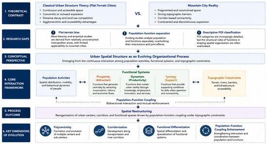
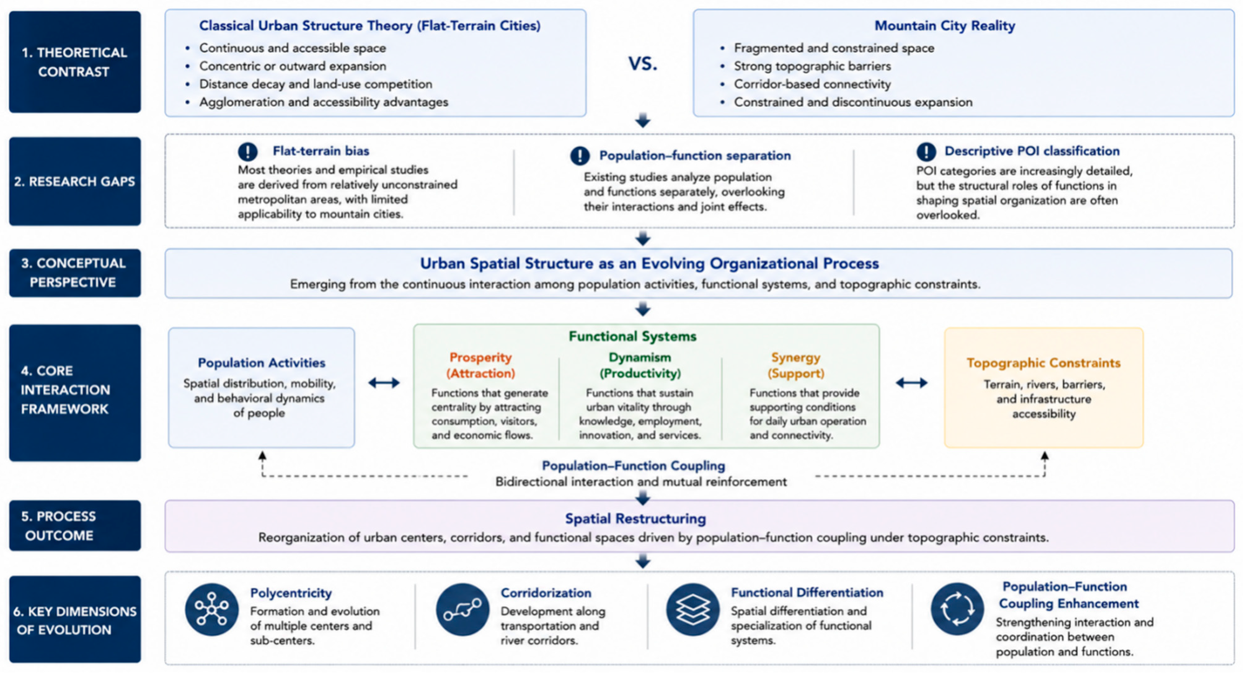
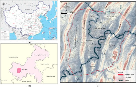
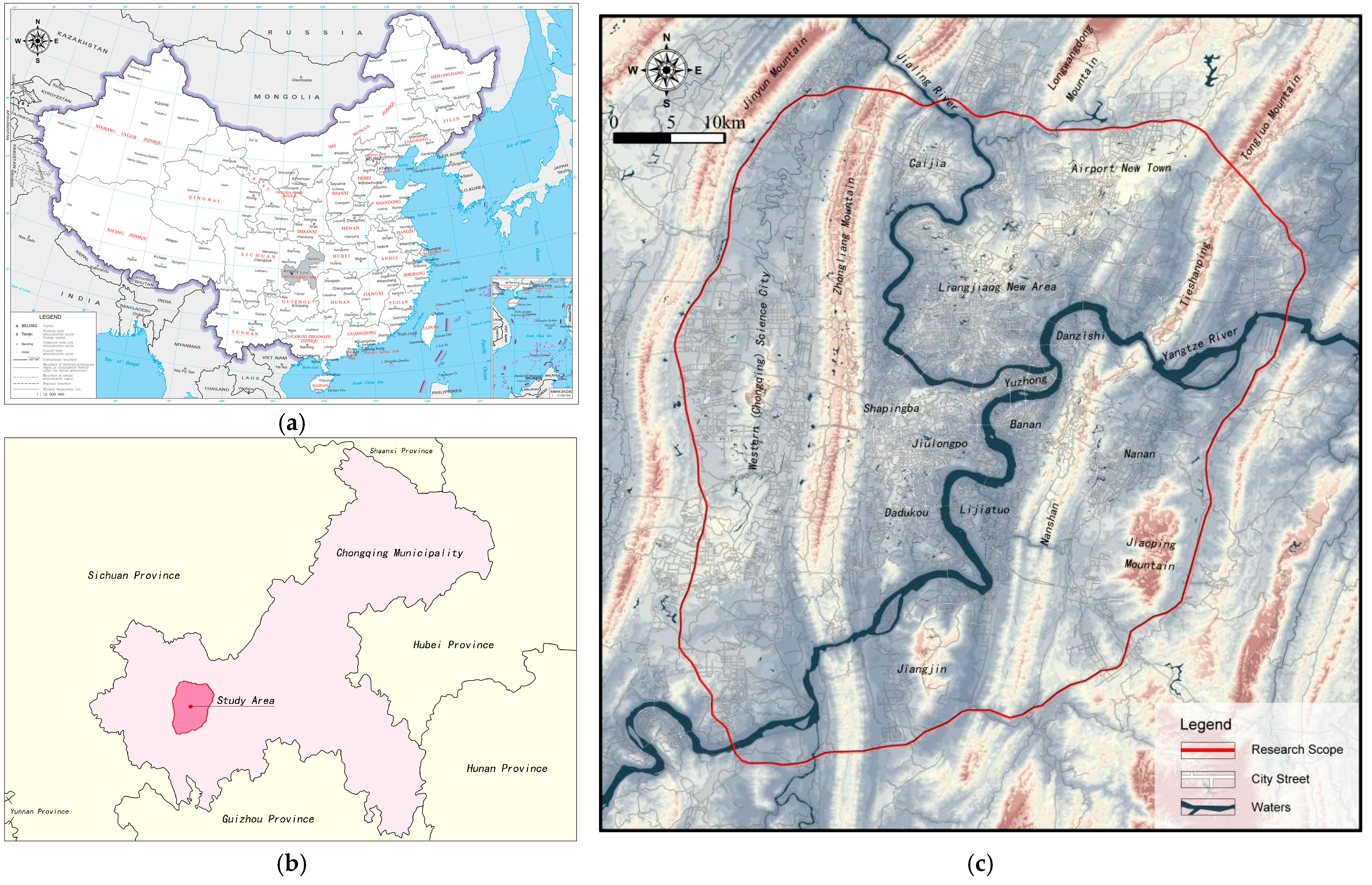
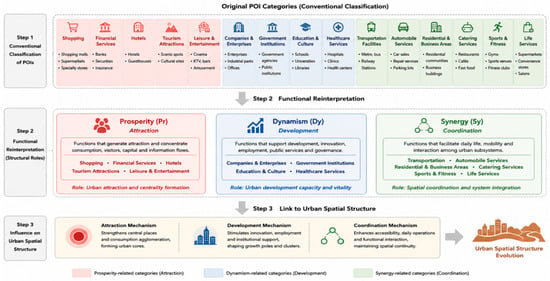
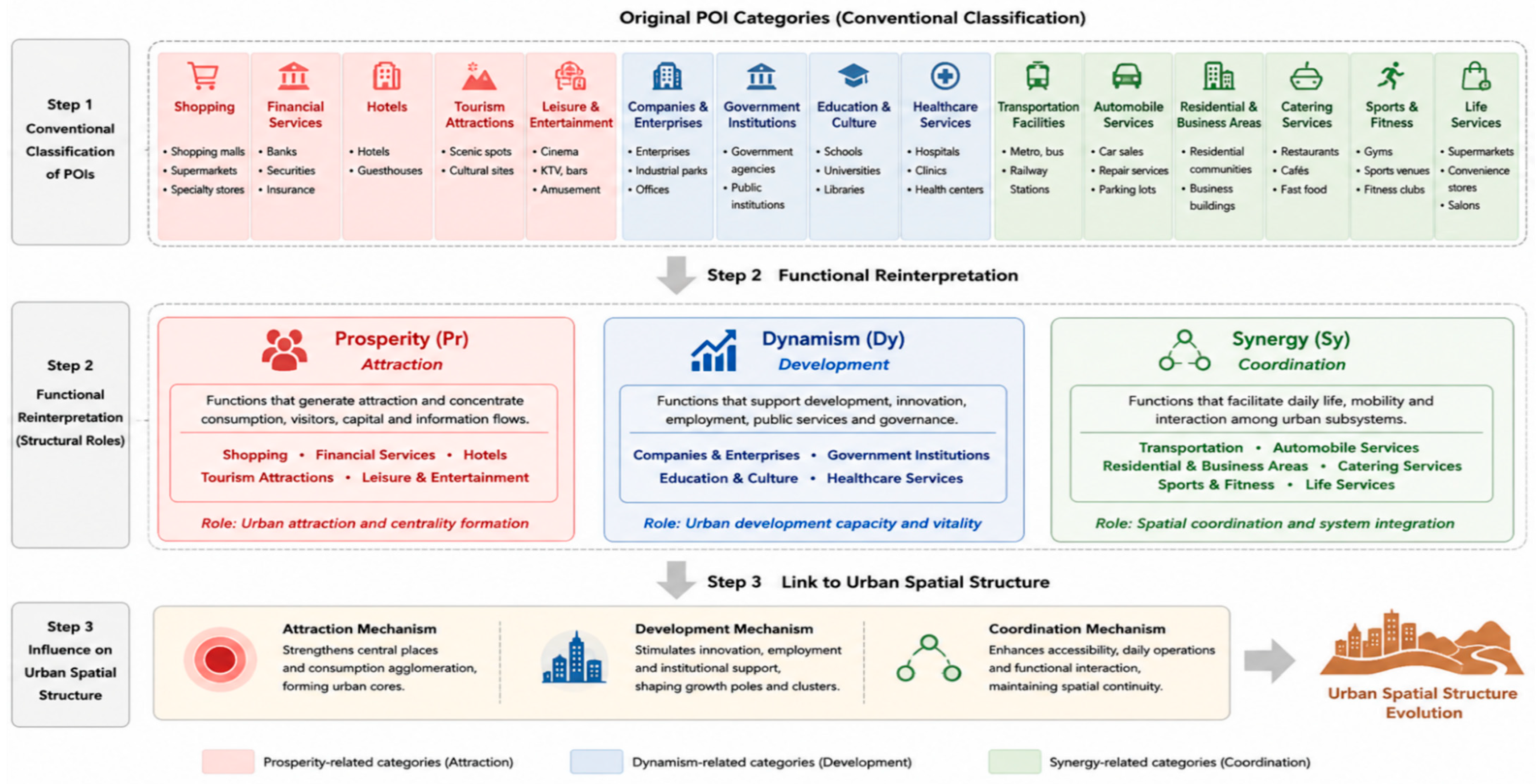
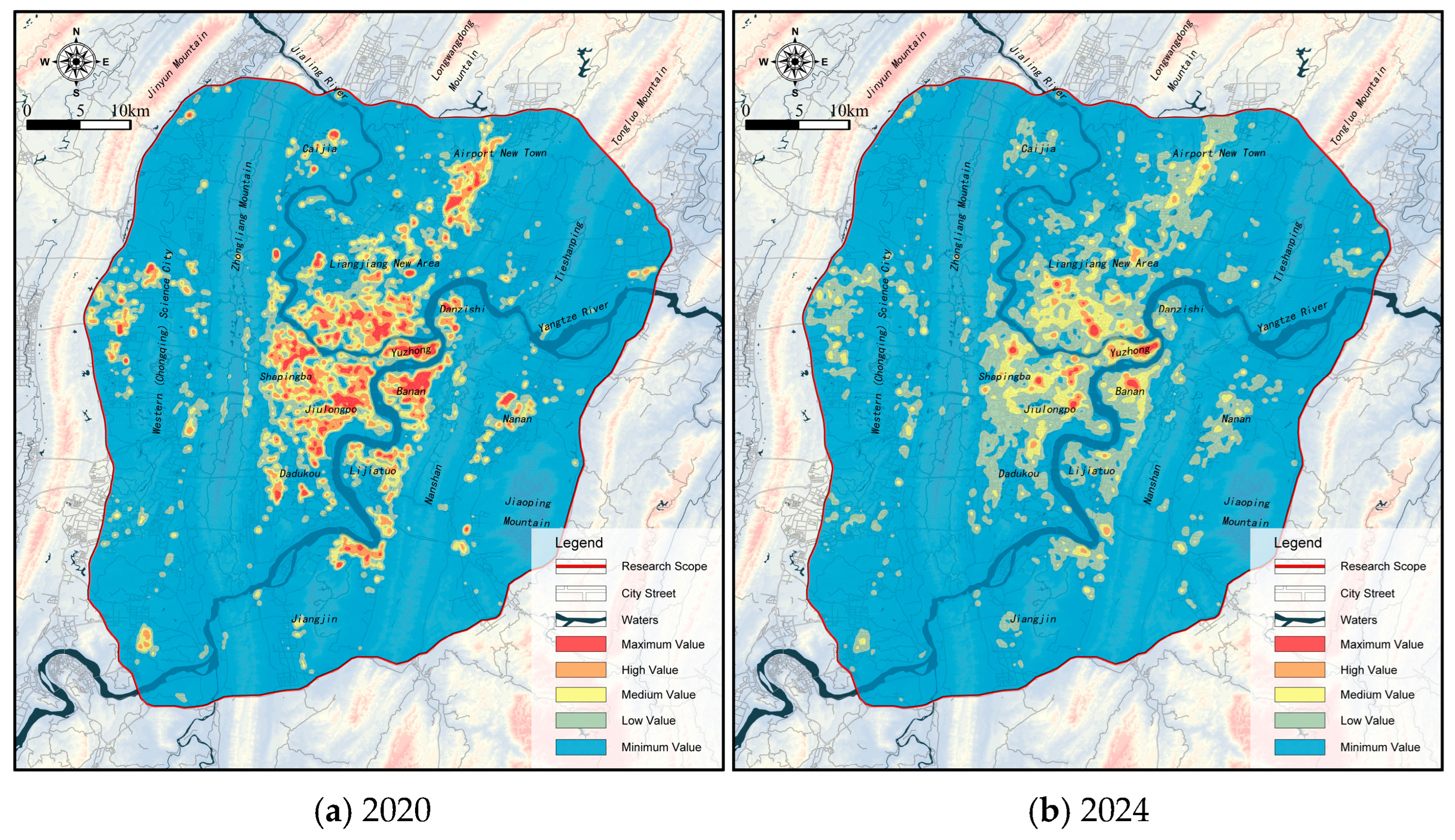
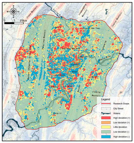
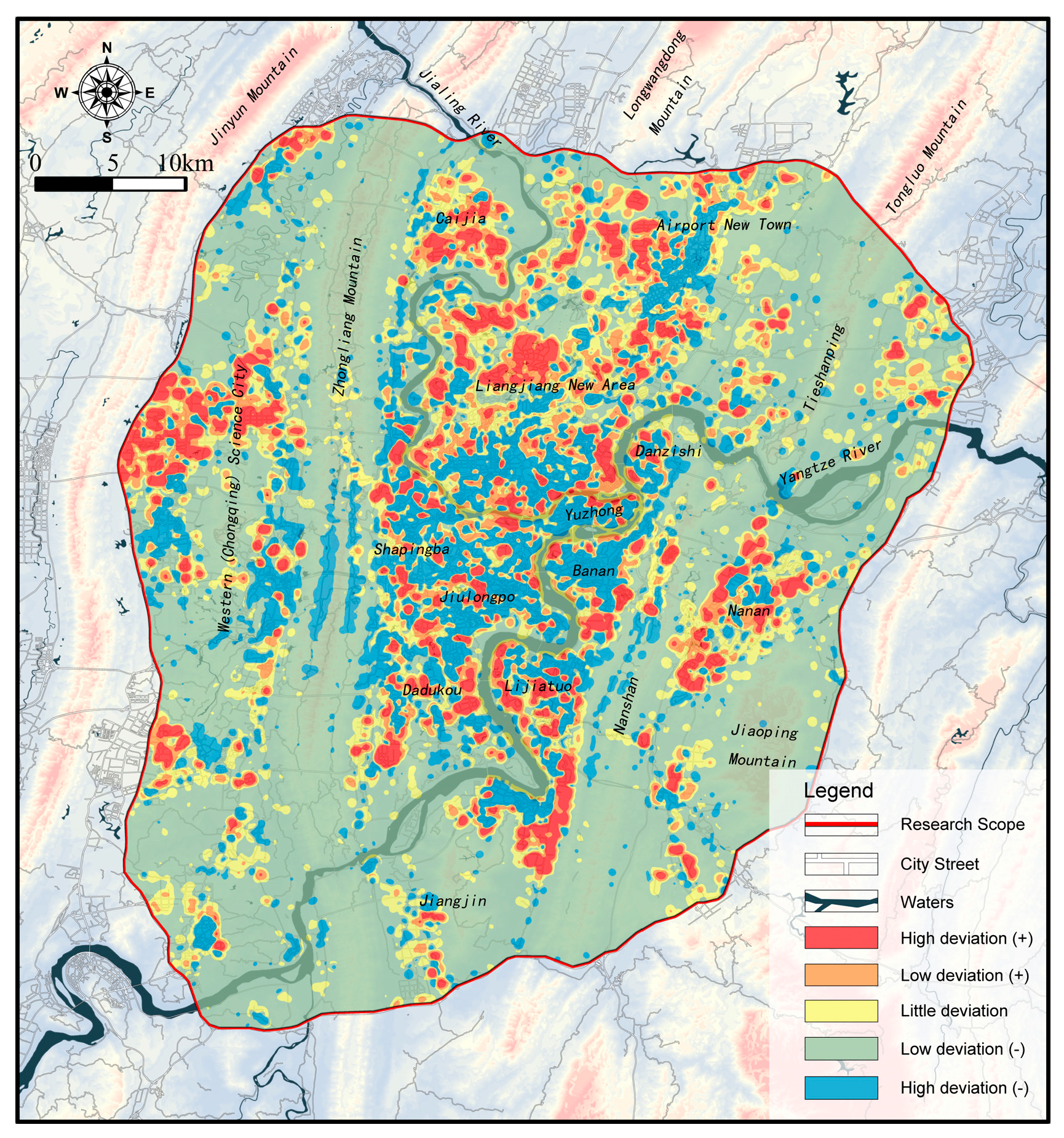
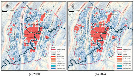
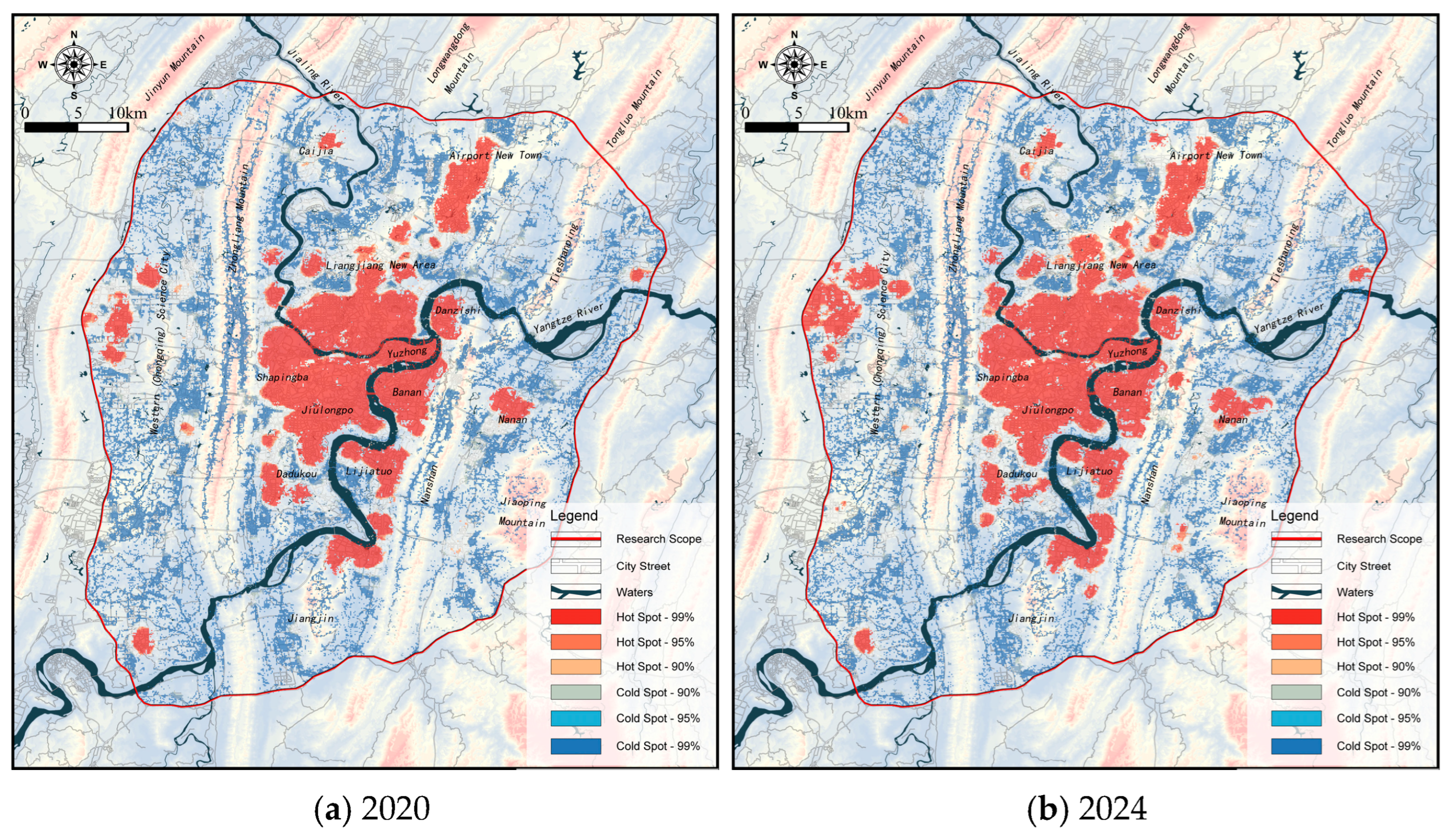
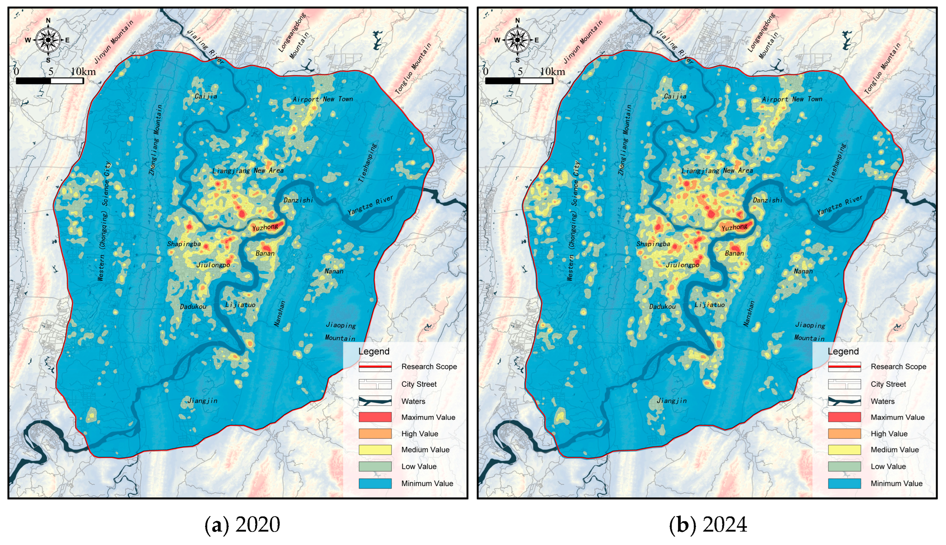
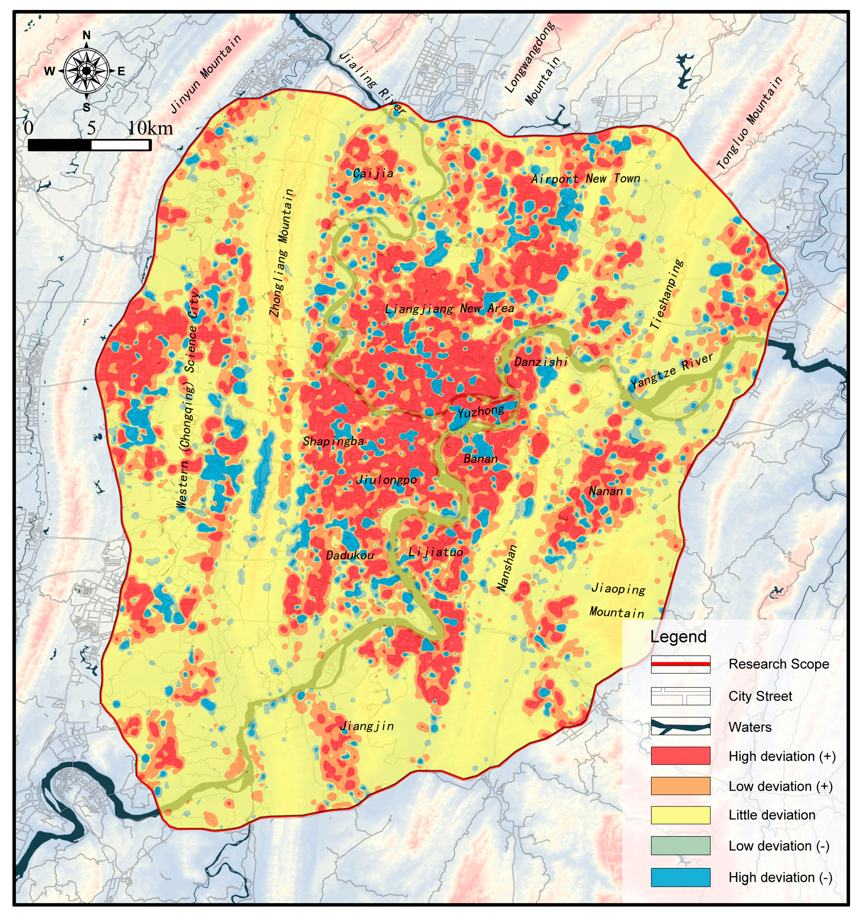
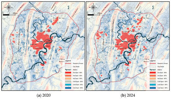
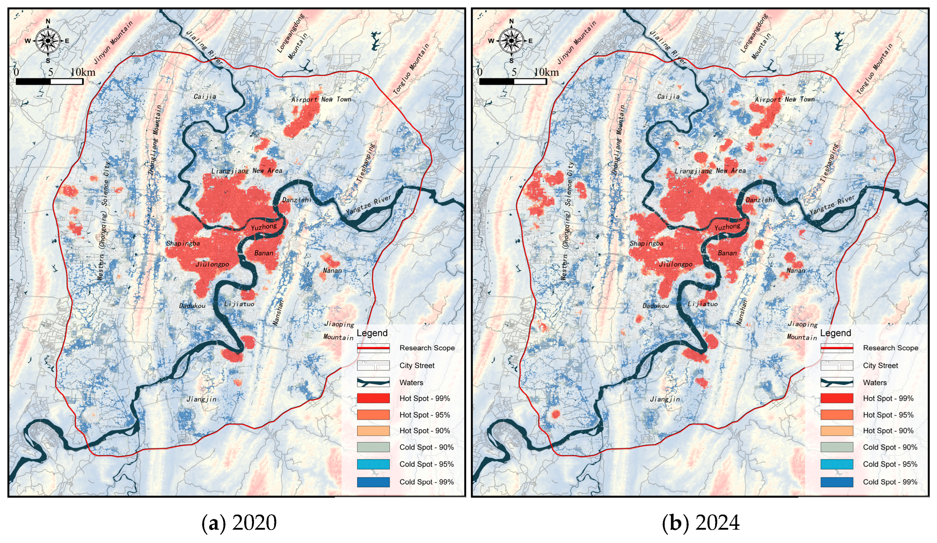
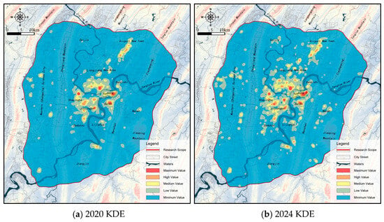
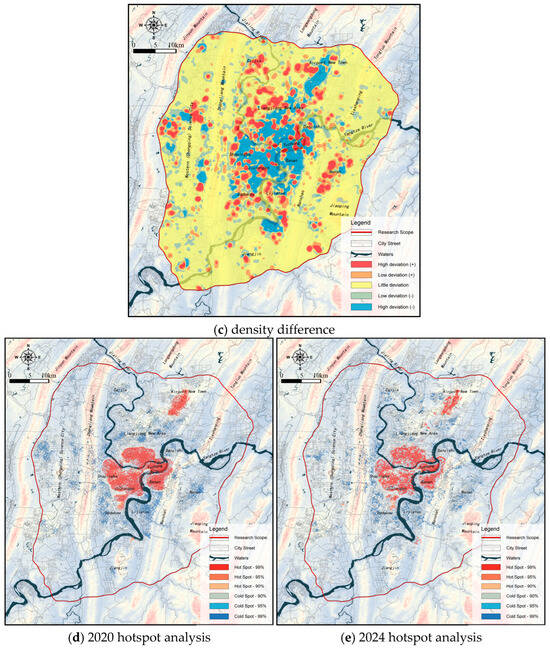
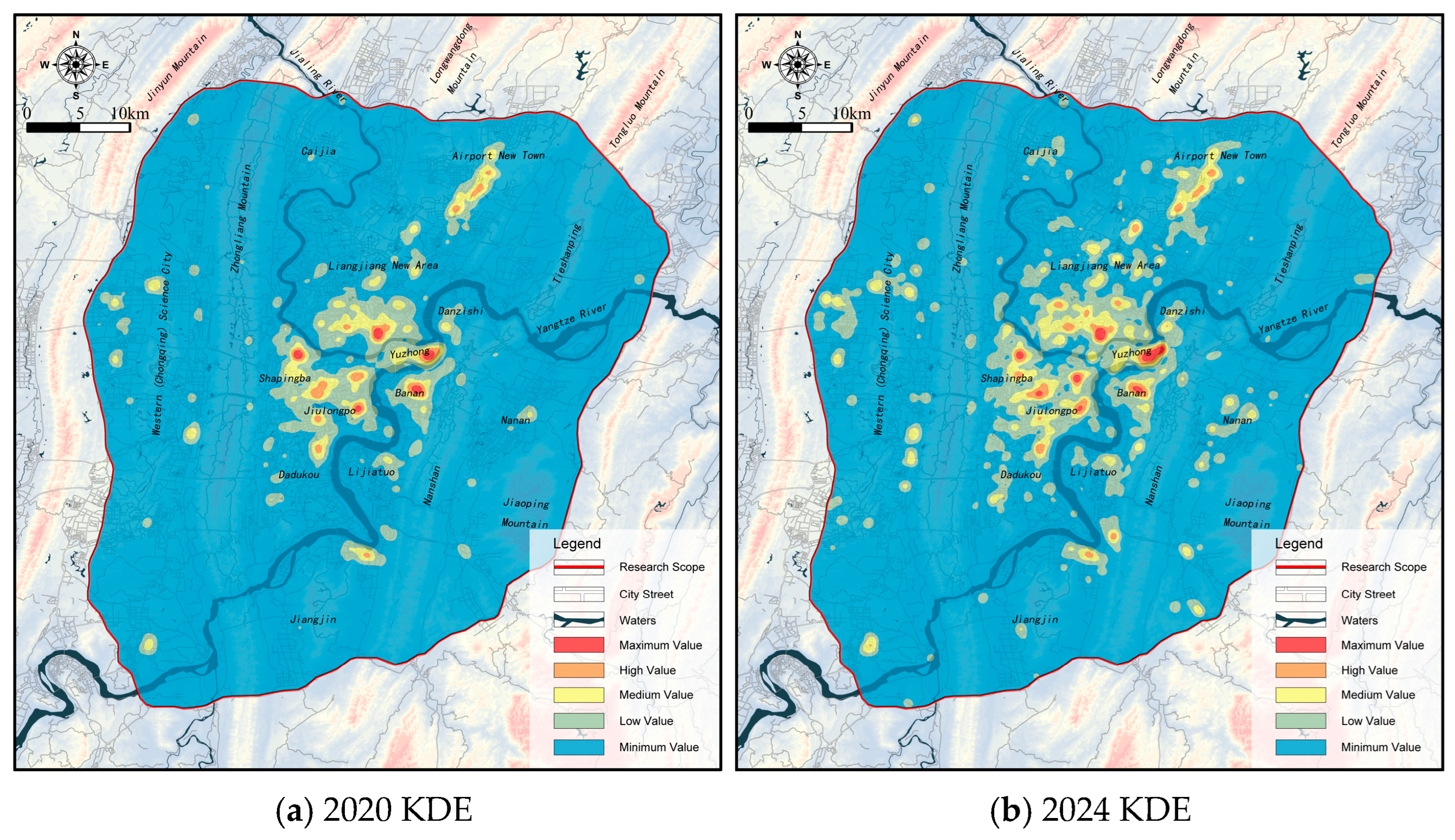
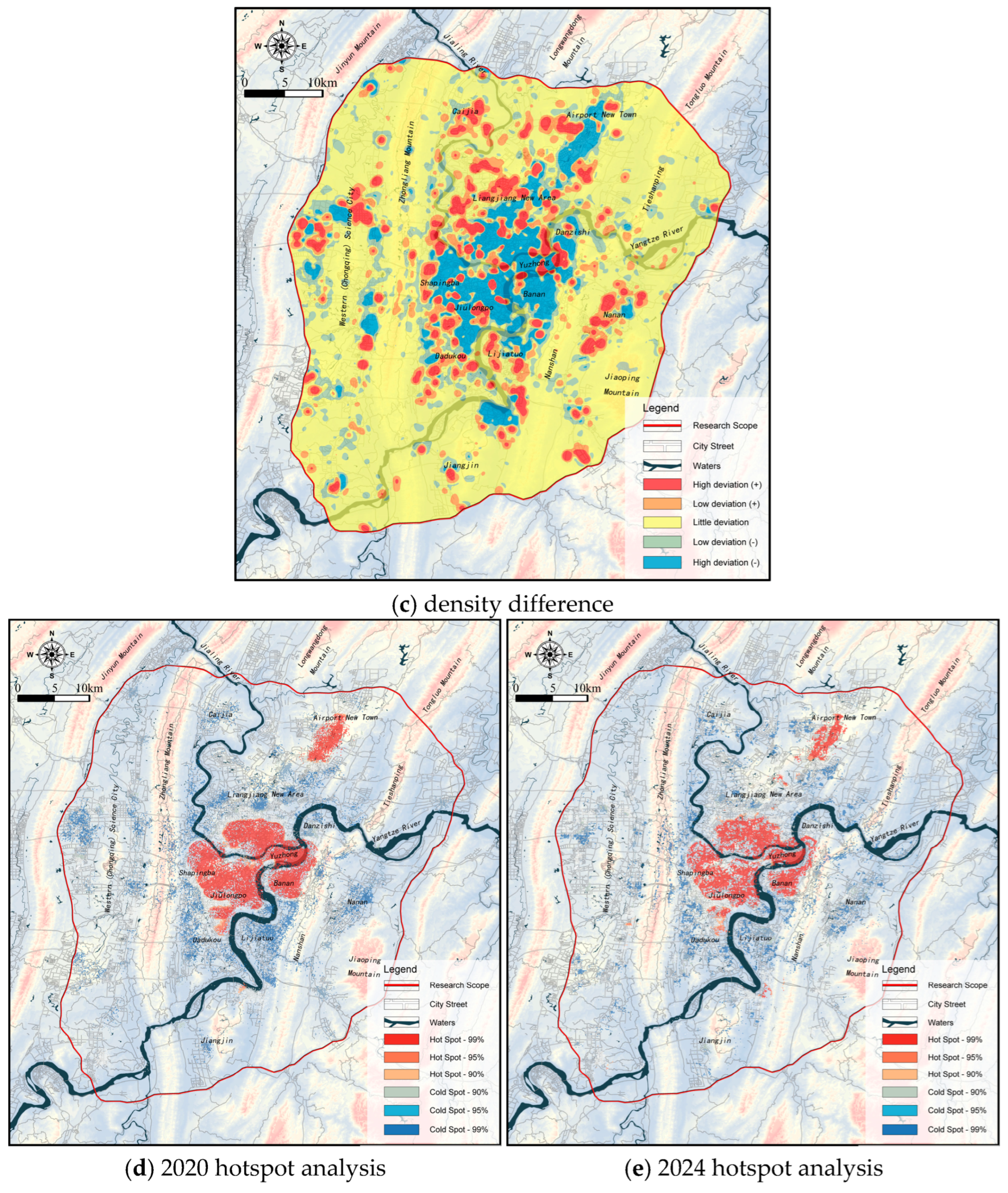
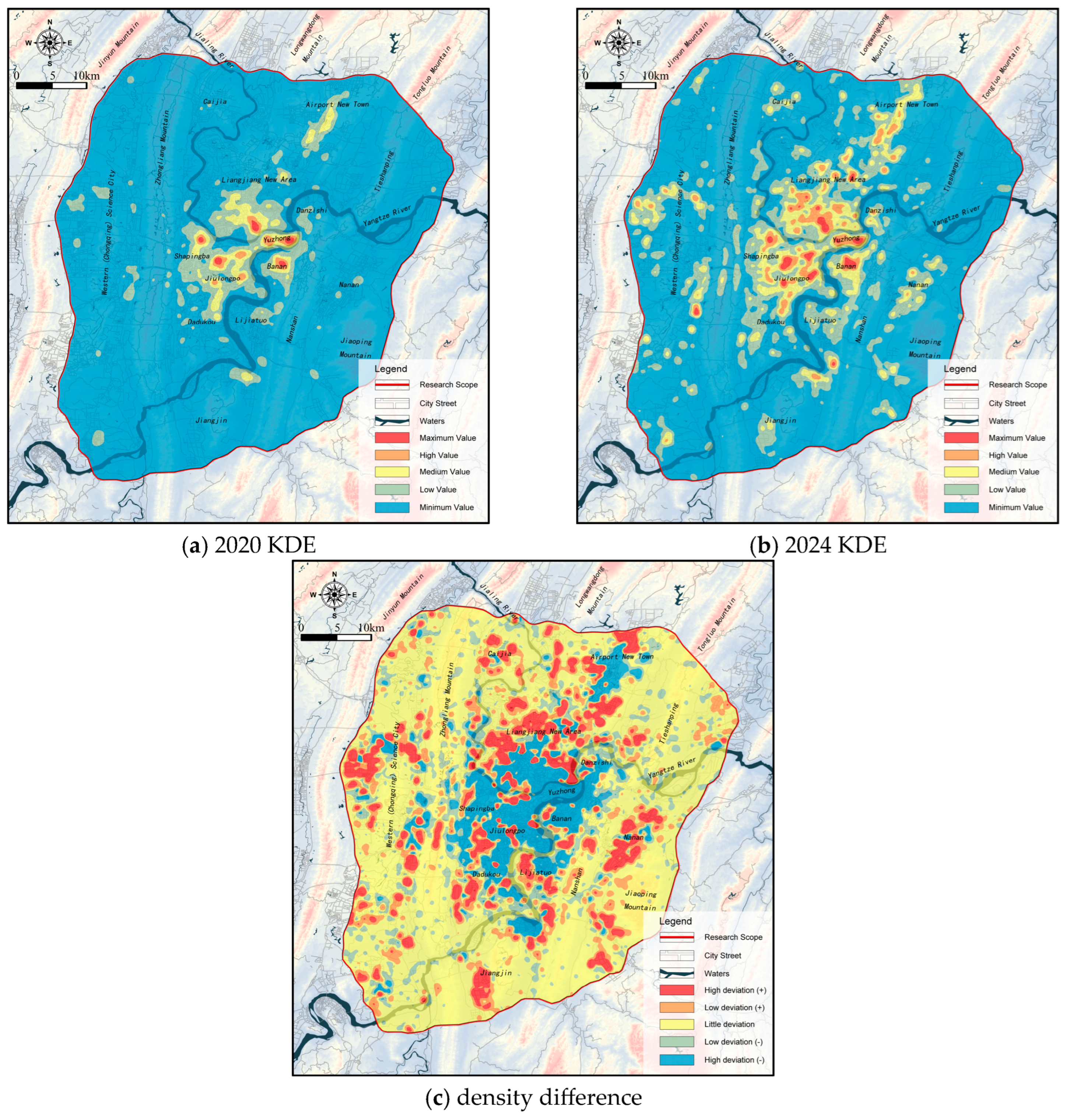
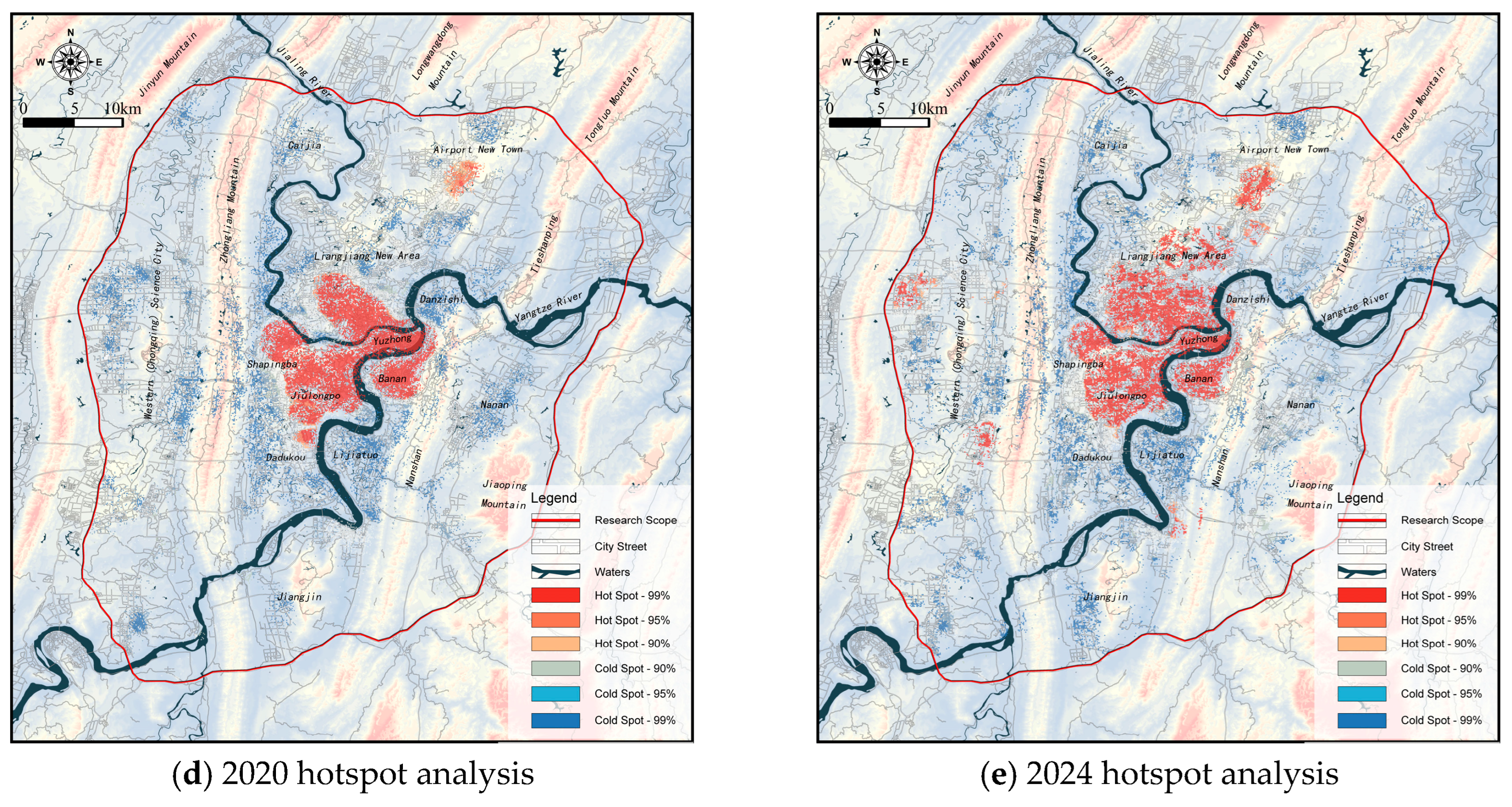
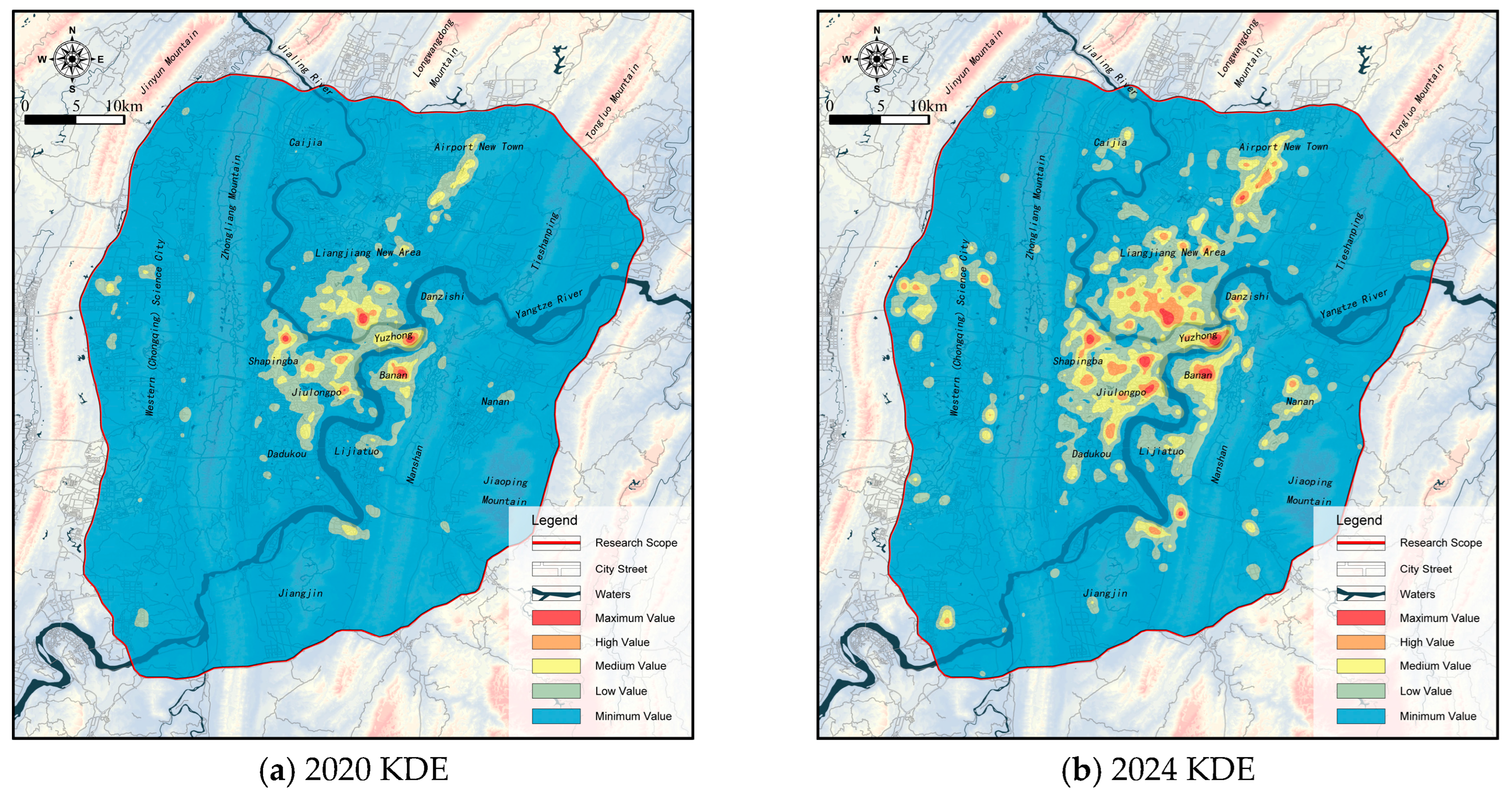
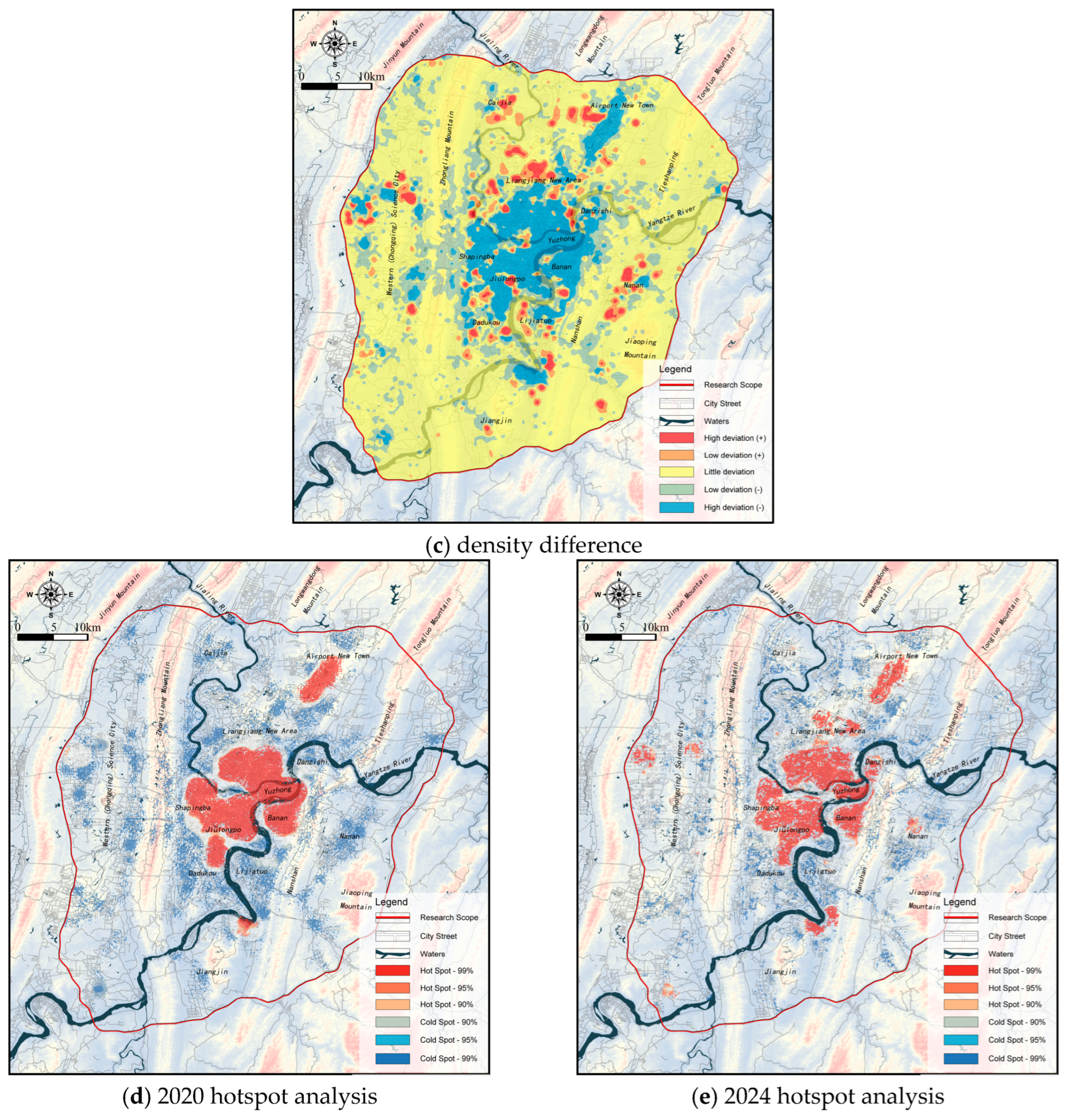
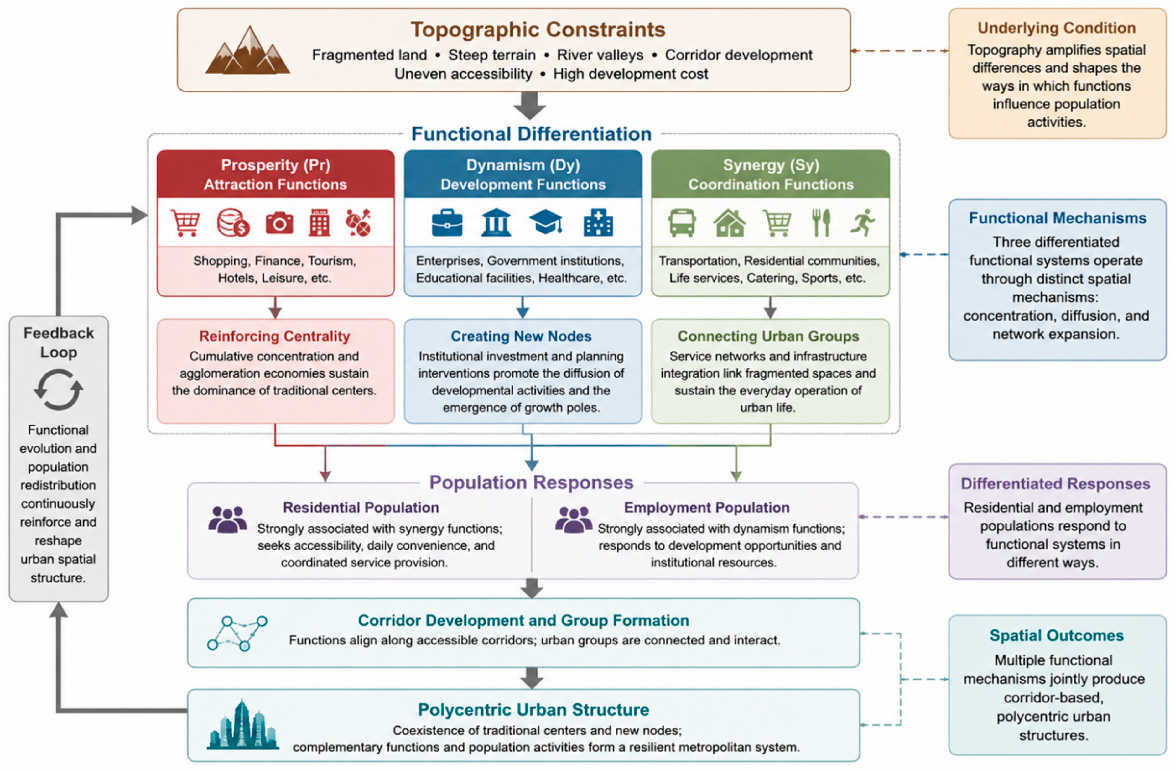

Disclaimer/Publisher’s Note: The statements, opinions and data contained in all publications are solely those of the individual author(s) and contributor(s) and not of MDPI and/or the editor(s). MDPI and/or the editor(s) disclaim responsibility for any injury to people or property resulting from any ideas, methods, instructions or products referred to in the content. |
© 2026 by the authors. Licensee MDPI, Basel, Switzerland. This article is an open access article distributed under the terms and conditions of the Creative Commons Attribution (CC BY) license.