


Abstract
The King Abdulaziz Public Transport Project in Riyadh is one of the massive undertakings that could transform mobility and quality of life in the Saudi capital. However, a full grasp of its many-sided consequences is still hard to obtain. The project is expected to deliver several positive outcomes, including decreased traffic congestion and better air quality, as well as increased mobility; however, it remains vital that the impact of this development on different aspects of urban life is studied using modern spatial analysis methods. This research seeks to address this gap by delving into the project’s influence on land use patterns, transportation behaviors, economic development, urban growth, environmental conditions, population dynamics, and road network efficiency. Using these techniques, some of the achievements and struggles of the project are identified in terms of service coverage, travel times, and how well it fits within Riyadh’s sustainability objectives to reduce car dependency and increase ridesharing. In conclusion, the study aims to contribute knowledge that supports urban planning, policy formulation, and future infrastructure projects so that the King Abdulaziz Public Transport Project is better aligned with the needs of this growing city for a workable, sustainable Riyadh. The King Abdulaziz Public Transport Project is a significant step towards improving Riyadh’s transportation system and achieving environmental, economic, and social sustainability goals. It will contribute to alleviating traffic congestion, improving air quality, boosting economic growth, and enhancing the quality of life for residents. Sustainable landuse planning around the stations, with the allocation of green spaces and public facilities, is essential.
1. Introduction
In the 21st century, transportation has become an essential issue. There has been a transition from what was once traditional transport to modern smart models, which better connect different destinations [1,2,3]. There has also been integration of active transport with urban mobility. This has prompted research into the basic elements and benefits of smart transport planning and an analysis of the issues in its implementation in Saudi Arabia. The study found that safety, comfort, and speed are what motivate Saudi Arabia’s push for smart transport [4,5]. Smart transportation offers numerous benefits, such as job creation, attracting investments, and optimizing resource utilization. This research also highlights several challenges in effectively planning smart transport systems in Saudi Arabia, including limited resources, regulatory frameworks, and the necessity for better-trained personnel [6]. Reviewing the types of existing transport systems and how they are planned, it is clear that the Kingdom should adopt all types of systems, put them under a uniform design, and adopt a comprehensive approach, as put forth by experts in both the public and private sectors. Close adherence to these recommendations is strongly advised for Saudi Arabia to realize the benefits of smart transportation. However, despite this progress, there is still a gap in understanding the successful implementation of intelligent transportation planning. This requires research into the issues, benefits, and basic elements of ITP in this context. This study looks at the degree to which ITP has played out in Saudi Arabia. It looks at the pillars and benefits of ITP as well as the issues at hand in this transition, which could improve implementation. Thus, this study is based on three questions:
- What are the fundamental pillars for implementing an ITP in Saudi Arabia?
- What are the benefits of ITP in Saudi Arabia?
- What challenges does Saudi Arabia face in implementing ITP?
Over the past decade, Saudi Arabia’s economy and population have witnessed remarkable growth, leading to increased demand for transportation and, consequently, significant market growth and increased private car use. In the present time, weak public transport infrastructure and the high number of fuel-efficient private cars cause traffic jams and increase pollution. The Kingdom is putting in great effort to support smart transportation, based on Vision 2030, which is seen as a solution to these issues. Vision 2030 is a wide-scale program whose goal is to make the Kingdom a logistics hub that connects three continents via better transport services. This also brought in the “National Transport and Logistics Strategy”. There are developments in air, land, and sea transport as specific areas that are focused on. Although there have been great efforts and growth in the awareness of the value of smart transport planning, the Kingdom still faces issues in the implementation of intelligent transportation systems. This includes a lack of funds, a lack of skilled labor, traffic jams, and poor stakeholder relations between different parties. Also, the present model of urban development is not sustainable and is a great threat to public health, the environment, and quality of life. It is very important that the community understands the issues of transport planning, the pros of intelligent transportation systems, and the issues the Kingdom is having in their implementation [7,8].
This study aims to look at the Public Transport Project in Riyadh and how it performs in terms of access, land use, population density, urban growth, and environmental sustainability using geographic information systems [GIS] and spatial analysis techniques [9,10].
In Riyadh, spatial and non-spatial data related to the public transport network, land use, population density, and vegetation cover were collected and analyzed. This involved the use of spatial analysis tools in ArcGIS, which included network analysis, overlay analysis, buffer analysis, hotspot analysis, and density analysis to study the project’s impact on various elements of the city. The study shows that the public transport project has achieved significant improvements in accessibility and connectivity between city areas and has contributed to stimulating urban and economic growth around metro stations. The study also indicates a slight increase in vegetation cover in some areas, indicating urban greening efforts and the role of the metro project in supporting these efforts.
2. Materials and Methods
Intelligent Transportation Systems [ITS]
Intelligent transportation is an innovation that integrates modern technologies into transportation systems, thereby improving the efficiency of urban mobility. An intelligent transportation system encompasses a wide range of technologies, including wireless communications and information technology, and primarily aims to enhance the usability, efficiency, and safety of the transportation network. Furthermore, intelligent transportation systems contribute to boosting the economic viability of a region, attracting tourists and visitors, and supporting social and cultural activities.
Intelligent transportation systems [ITS] combine improvements in information technology, systems, communications, sensors, control units, and advanced mathematical methods with traditional transportation infrastructure [11].
In Saudi Arabia, there is a clear need for reliable and safe transport. As part of Vision 2030 to improve road safety, increase connectivity, and develop public transport, there is a plan to include building a more flexible and sustainable transport network. The vision also includes the growth of smart cities that come with a variety of smart infrastructures. Further, the capital has a number of smart city projects that are key to the success of Vision 2030. The metro project, for example, includes Wi-Fi, CCTV, and auto power. Moreover, the authorities have implemented a central traffic management and monitoring system to handle the heavy traffic in the city. Also, it is noted that in the stakeholder community, there is a significant awareness of the importance of the transport sector. In addition, the area is a key passageway for trade between Europe, the Middle East, Africa, and Asia. With the right technologies and sound planning, Saudi Arabia can easily capitalize on its strategic location and maximize the profits generated by increased traffic.
The push for growth in the transportation sector in the Kingdom goes beyond tech improvements and strategic location issues. There is a plan to minimize heavy reliance on oil and to introduce other elements that play into economic diversity. Also, the government is keen to introduce smart solutions to transport issues, adopting worldwide innovative tech and reducing fuel use by 25%. There is also a tendency to raise the transport and logistics sector’s role in GDP to 10%, which is higher than the present 6%.
3. Transport Infrastructure in the KSA
Over a span of four decades, the Kingdom of Saudi Arabia, with a vast land mass and a population of over 31 million, has seen great urban growth in most of its cities. For that growth to bring about development, more jobs and business opportunities, and greater investment, it requires efficient and smart transport infrastructure. These benefits stem from advanced transportation systems, including roads, railways [12], airports, and seaports. This understanding has encouraged Saudi Arabia to invest heavily in developing intelligent transportation networks [13,14,15].
3.1. Key Initiatives and Technologies
- Riyadh metro: Forming the backbone of the system, it features automated electrification, a Wi-Fi network, surveillance, and integrated intelligent transportation systems to provide real-time data and passenger information [16].
- Smart roads: Upgrading major streets [such as Abu Bakr Al Siddiq and Urban Streets] with advanced intelligent transportation systems for tunnel management, ventilation, and control centers.
- Central traffic control: A centralized system that monitors and manages large traffic volumes using sensors, cameras, and artificial intelligence to find sustainable solutions [17].
- Artificial intelligence and Internet of Things: Using artificial intelligence and deep learning to process images, vehicle camera data, and sensors to create a continuous city database and predict traffic flow [18,19,20].
- Bus network: The Riyadh Bus Project utilizes intelligent transportation systems to automatically locate vehicles [AVL] and provide real-time passenger information [RTPI].
- New Square Project: A large-scale new district featuring smart infrastructure and future-oriented transportation concepts.
3.2. Conceptual Framework
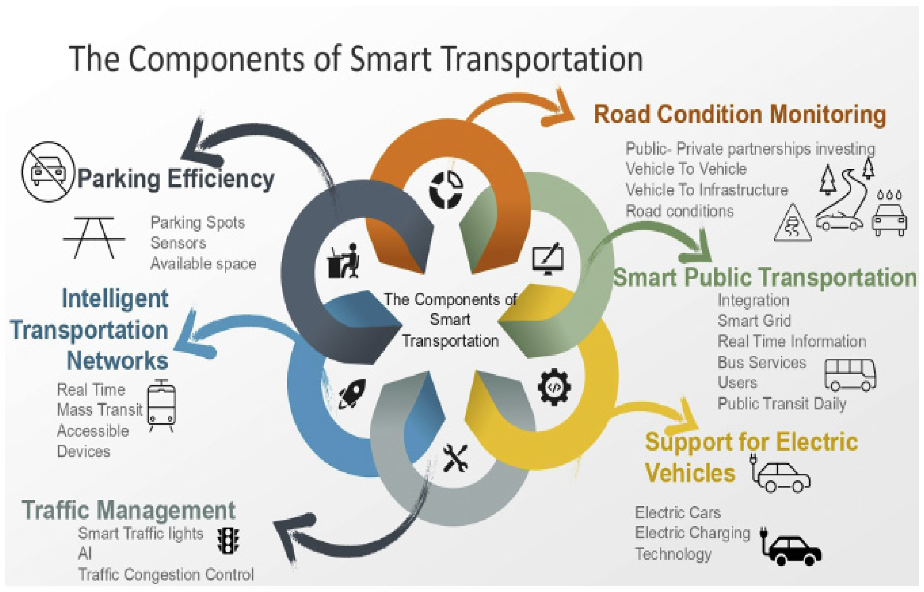
In addition to reducing traffic and pollution, intelligent transportation [IT] offers ways to improve urban mobility and inhabitants’ quality of life in general [21]. Transportation network management, information transmission, and traffic flow control are made possible by the use and deployment of sophisticated electronic, communication, and computing technology.
When integrating cutting-edge technology into transportation systems, the four fundamental ideas of sustainability, safety, responsiveness, and integration are essential. These ideas are essential to accomplishing IIT’s primary goals, which are accessibility, mobility, environmental sustainability, and economic development. The following is a summary of the elements of IIT:
- Efficient parking: Sensors enable drivers to pre-identify available parking spaces, eliminating the need for lengthy searches [22].
- Smart transit networks: Real-time updates on public transport schedules and maintenance disruptions are accessible via smartphones and tablets [22].
- Traffic management: Smart traffic signals, powered by real-time data and artificial intelligence, help address traffic congestion issues effectively and quickly.
- Road condition monitoring: Public–private partnerships investing in public transport and vehicle-to-infrastructure [VTIC] technologies improve real-time road condition updates and prevent traffic congestion.
- Smart public transport: Integration with smart networks provides real-time information on bus services, particularly for job seekers, frontline workers, and those who rely on public transport daily.
- Support for electric vehicles: Installing electric vehicle charging stations in high-traffic areas attracts electric vehicle drivers, provides them with convenience, and promotes the adoption of advanced and sustainable vehicle technologies in the future.
- Accident reporting [22].
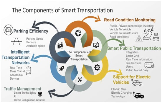
- A smart transportation system can be visualized as comprising of three basic functionalities. This includes smart vehicles, smart parking and smart roads. This is being highlighted in Figure 1. Smart roads are implemented by the usage of various sensors and actuators to make driving safer and greener.
Figure 1.
The components of smart transportation [10].
In addition to the digital technologies used to scope the SLR, this paper summarizes six enabling technologies that can facilitate the smooth adoption of smart mobility, of which five are digital [IoT, blockchain, big data, artificial intelligence, geospatial technology, and clean energy].
4. Methodology
4.1. Study Setting and Research Design
This study focuses on intelligent transportation planning in the Kingdom of Saudi Arabia, considering the benefits, challenges, and characteristics of an intelligent transportation system. A qualitative research design was employed to closely examine the transportation sector in Saudi Arabia, using Riyadh as a case study. This approach involved analyzing reliable and valid secondary data sources. This research design is fundamentally aligned with the study’s objective of examining intelligent transportation planning in Saudi Arabia.
The concept of intelligent transportation can be simplified into three basic elements: management, efficiency, and safety. In other words, what is put forth in intelligent transportation is the use of present and emerging technologies to improve urban mobility, to make it a cheaper option for the city and the individual, and to make it safer. Also, there is a focus on 3 main dimensions: [a] smart cells, [b] information and communication technologies [ICTs], and [c] development mechanisms. Smart cells include smart cars, drones, smart infrastructure and devices, and smart base stations, which run on ICTs and are enabled by many development mechanisms:
- Real-time traffic updates and management [11].
- Demand-responsive public transport/on-demand transport.
- Smart ticketing.
- Ridesharing [12].
- Smart parking system.
- Public transport management.
- Mobility as a service [MaaS].
4.2. Challenges Facing Saudi Arabia in Implementing Intelligent Transportation Planning
In the present study, it is found that Saudi Arabia is keen to transform urban areas into smart and sustainable cities. That transformation has brought with it both opportunities and problems for Saudi citizens.
As for smart transport, which is a key element of this urban transformation, public transport is identified as the main player in reducing private vehicle use. In the case of Saudi Arabia, adopting public transport is exposed to several obstacles, mainly due to two factors.
First, public transport infrastructure has not yet reached its full development, which has resulted in a very limited and, in some cases, inefficient network. This does not appeal to the public and is hard to access.
Second, having a private car is part of the Saudi culture due to the easy access to cars and the low price of fuel. This has, in turn, led to a significant increase in the number of cars on the road, which has caused massive traffic problems and higher pollution levels.
Among the key challenges identified in the analysis are the use of digital surveillance and information and communication technologies, and the integration of smart technology into intelligent transportation planning. This has been linked to residents’ security and safety concerns, impacting their privacy in both the private and public sectors. The city administration lacks the full capacity to explore digital technologies to address urban transportation planning challenges.
5. Riyadh City—Case Study
The King Abdulaziz Public Transport Project is part of the Royal Commission for Riyadh City’s ambitious city plan to equip Riyadh with public transport that provides all population groups with suitable public transport services, accommodating existing and future mobility needs in Riyadh.
In Riyadh, the authorities are working to create, run, and develop a best-in-class rapid transit system, which will put in place affordable, convenient, and time-efficient transport options for all citizens in the city. The project will significantly contribute to improving traffic flow, the economy, society, and the environment in Riyadh. The public transport network will create a cohesive city characterized by:
- Six Metro Lines;
- 85 metro stations;
- 80 bus routes;
- 2860 bus stops;
- 842 buses.
The network was developed according to the following criteria:
- Population density and distribution.
- Connecting key points of interest, such as ministries, universities, hospitals, shopping malls, transportation hubs, and government facilities.
- Expected traffic volume on the roads.
- Expected number of passengers.
- Travel time on each line of the public transport network.
- Reducing traffic congestion and vehicle emissions.
- As part of enhancing the transportation system in Riyadh and preparing it to become a leading hub for sustainable mobility and logistics services in the Middle East, His Royal Highness Prince Mohammed bin Salman bin Abdulaziz, the Crown Prince, Prime Minister, and Chairman of the Board of the Royal Commission for Riyadh City, launched the Riyadh Main and Ring Road Axes Development Program.
In the program, a network of 500 km of roads has been implemented and developed in the capital. New roads were added, the main existing corridors were improved, and all of these were integrated into a smooth and efficient system.
6. Program Phases
The program has a number of project groups in place that cover different areas of the city, which in turn ensure an even distribution of effort and a coordinated execution of works in very organized phases.
GROUP ONE: Work for the second group started on the 14 August 2024. It included four main development projects at a total cost of over SAR 8 billion. This group marks the baseline for the program; it improved connections in outlying areas of the city and bettered traffic flow in the west.
GROUP TWO: Work for the second group was inaugurated on the 2 February 2025. It included eight development projects at a total cost of over SAR 8 billion. What sets this phase apart is that it has a larger geographical reach and a focus on improving the city’s internal traffic flow and better connections between the north, east, and west of the capital.
GROUP THREE: Implementation works for the third group were launched on 29 December 2025. This group includes six projects with a total cost exceeding SAR 8 billion, and will be implemented within 3–4 years.
Riyadh Metro Project
The metro project is the backbone of Riyadh’s public transport network, with a capacity of 3.6 million passengers daily. Comprising six lines with a total length of 176 km and 85 stations, the metro covers most densely populated areas, public facilities, and educational, commercial, and medical institutions. It connects King Khalid International Airport, the King Abdullah Financial District, major universities, downtown Riyadh, and the city’s public transport hub.
7. Metro Lines
- Blue line: Axis of Al-Olaya–Al-Batha–Al-Hayer roads, with a total length of 38 km.
- Red line: Axis of King Abdullah Road, with a total length of 25.3 km.
- Orange line: Axis of Al-Madinah Al-Munawarah Road–Prince Saad Bin Abdurrahman I Road, with a total length of 40.7 km.
- Yellow line: Axis of King Khalid International Airport Road, with a total length of 29.5 km.
- Green line: Axis of King Abdulaziz Road, with a total length of 12.9 km.
- Purple line: Axis of Abdurrahman Bin Awf Road–Sheikh Hassan Bin Hussain BinAli Road, with a total length of 29.7 km.
What Riyadh Does Well In Urban Mobility
Riyadh has a large road network, and the government is making major investments to enhance its quality and interconnectivity. As part of its Vision 2030 plan, the government intends to enhance over 500 km [311 miles] of roads in the capital to improve traffic fluidity and decrease commute times. The Royal Commission for Riyadh City [RCRC] awarded SAR13 billion [USD 3.5 billion] in 2024 to four major construction projects focused on developing the city’s main and ring roads.
Riyadh’s adoption of connected and autonomous vehicles is high relative to other cities of similar rank. The Transportation General Authority set an ambitious target of having 25% of transport vehicles be autonomous in Saudi Arabia by 2030. The government laid the foundations in 2024 by adopting new road code standards for autonomous vehicles. Currently in a testing phase, the code is expected to become binding by early 2025.
How can Riyadh improve its urban mobility performance?
Despite national investments to encourage the use of electric vehicles and install charging infrastructure, the use of electric buses as part of a zero-emission bus service is still lagging. One company launched an electric bus for its employees in August 2024, but as of 2024, there were no public electric buses in Riyadh’s fleet. Acquiring more electric buses would help achieve Vision 2030’s goal of halving carbon emissions by 2030. As in most Gulf countries, many residents prefer to use private cars, leading to high levels of congestion. The city could improve traffic flow by implementing congestion charges or enhancing last-mile connectivity through innovative solutions. It could also encourage active mobility, including cycling. While the hot climate is a challenge, the lack of suitable infrastructure also discourages the adoption of these modes of transport. To improve the situation, Riyadh could create dedicated cycle lanes with safety features such as barriers and bicycle-specific traffic signals. As part of the Sports Boulevard Project, Riyadh aims to create 220 km [137 miles] of cycle paths to connect the eastern and western parts of the city. Riyadh could also invest in bike-sharing programs, focusing on e-bikes to overcome some of the challenges of the hot climate. The city could consider offering financial support for the purchase of bicycles and e-bikes to encourage their use.
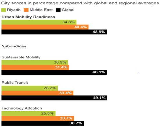
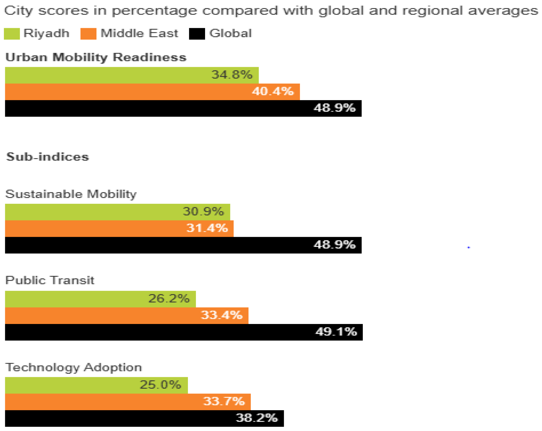
Figure 2 shows the urban mobility readiness index, sustainable mobility, public transport, and technology adoption levels in Riyadh, as well as its comparison with the Middle East and other countries worldwide.
Figure 2.
Urban Mobility Readiness Index, sustainable mobility, public transit, and technology adoption scores [10]. Dimensions of the Urban Mobility Readiness Index score.
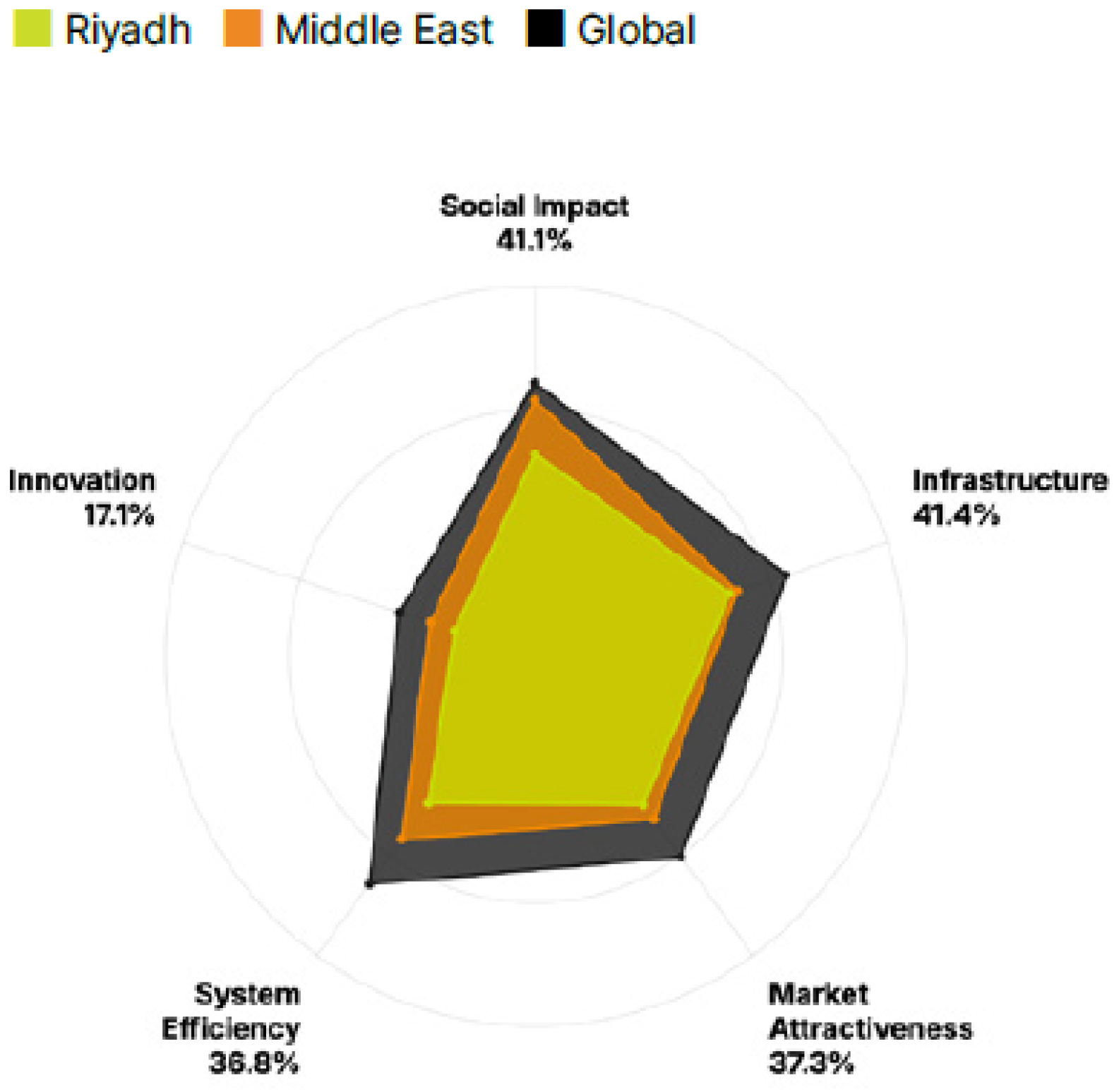
The five dimensions that make up the overall index score are defined as follows in Figure 3:
- Infrastructure: Evaluates the physical and structural capacity of a city’s mobility network, including public transit density, road quality, and electric vehicle (EV) charging availability.
- Social Impact: Measures how well the mobility system serves the public, encompassing affordability, safety, equitable access to transit, and health/environmental outcomes.
- Market Attractiveness: Assesses the city’s ability to stimulate economic activity and foster private investment, including the ease of doing business and the presence of dynamic mobility ecosystems.
- Systems Efficiency: Gauges the operational effectiveness and connectivity of the transit network, analyzing metrics like daily commute times, reliability, and transport utilization rates.
- Innovation: Measures a city’s forward-looking capacity to adopt advanced technologies, such as artificial intelligence, autonomous vehicles, and the regulatory support for smart mobility services.
Figure 3.
City scores in percentage across the five dimensions compared with global and regional averages [16].
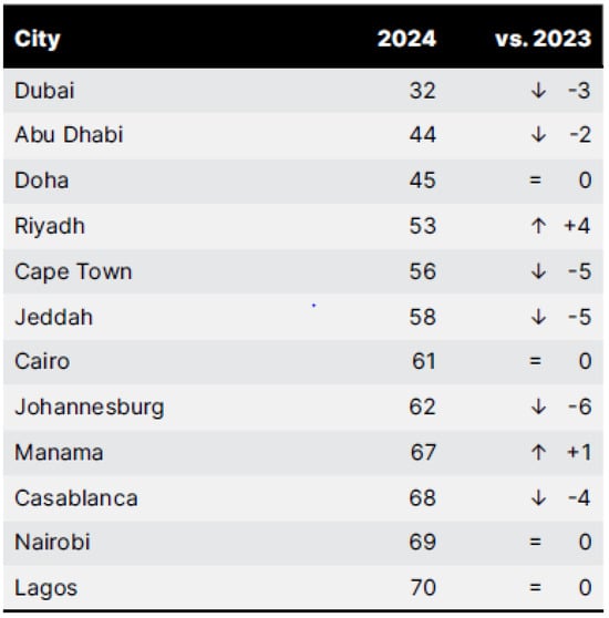
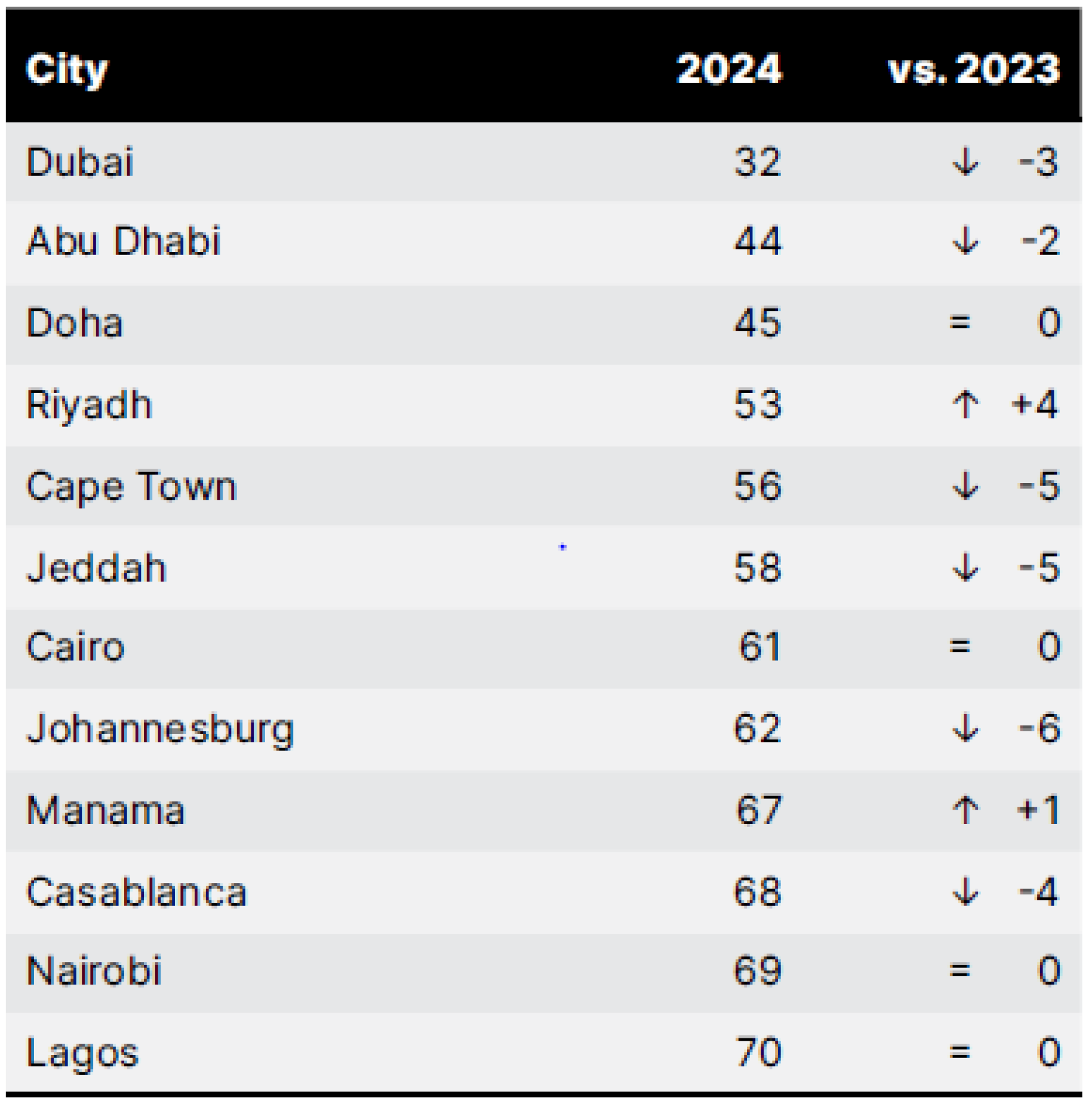
The urban transport sector in the Middle East and Africa faces challenges, with many cities still lagging behind global averages. However, significant investments are being made, including in public transport services. Cities like Dubai and Doha have invested in driverless metro systems, while Cape Town is expanding its bus rapid transit system. Lagos recently launched its first metro line, and Jeddah is working to implement affordable fares and convenient services, contributing to its gradual rise in the rankings, as illustrated in Figure 4.
Figure 4.
Middle Eastern and African cities’ Urban Mobility Readiness Index 2024 rank and evolution versus 2023 [17].
The previous table in figure represents the growth rate compared to 2023 and 2024. The equals sign (=) indicates no significant growth from 2023 to 2024, while the plus sign (+) represents the city’s growth rate in both 2023 and 2024. The arrow (⇧) represents the percentage increase in growth, and the arrow (⇩) represents the percentage decrease in growth for the city.
To improve urban mobility, particularly in Middle Eastern and African cities, the focus should be on developing public transport services. Investing in bus networks, with an increased number of stations and routes, is a cost-effective way to increase station density and extend service to underserved areas. Creating dedicated pedestrian and bicycle lanes and investing in electric bike-sharing programs to facilitate mobility in hot climates will also significantly improve mobility, especially for disadvantaged residents. Furthermore, prioritizing road safety through improved traffic management, law enforcement, and public awareness campaigns, particularly through various media outlets and social media platforms, will help reduce fatalities and create safer urban environments. Cities aspiring to use electric vehicles can also increase their investments in incentivizing their adoption and developing charging infrastructure.
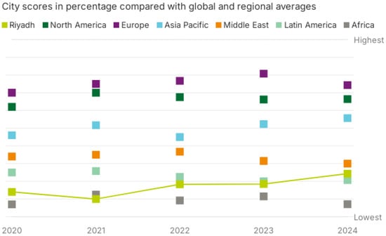
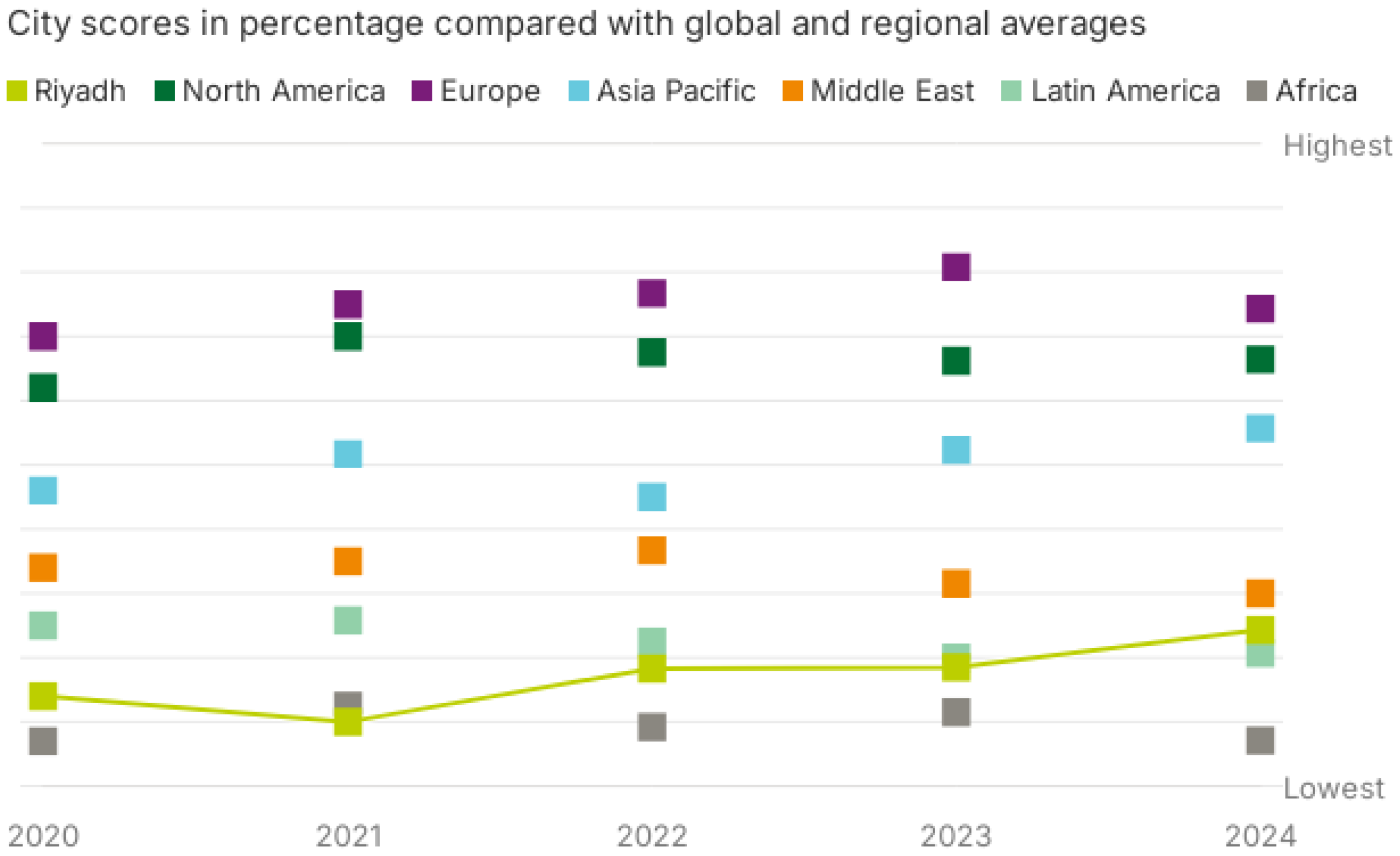
The Urban Mobility Readiness Index assesses global cities across dozens of criteria to measure their preparedness for future transportation trends. This framework ranks cities into key sub-indices, including sustainable mobility and public transport, while also evaluating technology adoption within an innovation framework, as illustrated in the Figure 5.
Figure 5.
Urban Mobility Readiness Index relative ranking evolution [2020–2024] [19].
Intelligent transportation in Riyadh using GIS
Study design: This study adopts a mixed-methods research approach, integrating both quantitative and qualitative methods to analyze the impact of Intelligent transportation planning and its challenges in the Kingdom of Saudi Arabia—Riyadh City case study.
7.1. Data Collection
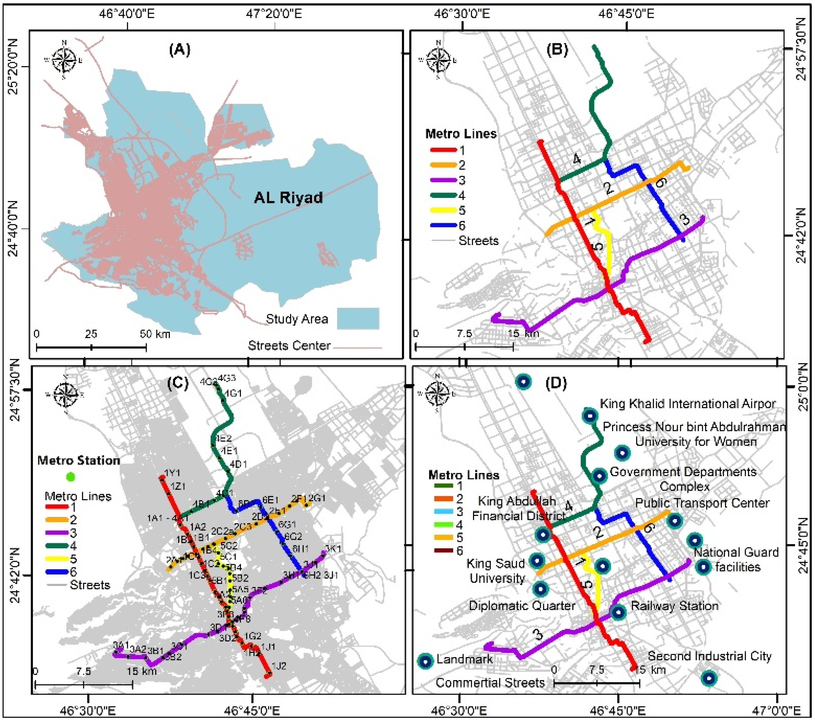
Figure 6 shows the locations of (A) street centers, (B) metro lines, (C) metro stations, and (D) commercial streets in Riyadh.
Figure 6.
Locations of (A) street centers, (B) metro lines, (C) metro stations, and (D) commercial streets.
7.2. Park and Ride Facilities
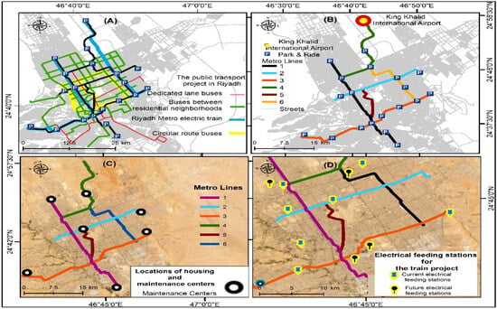
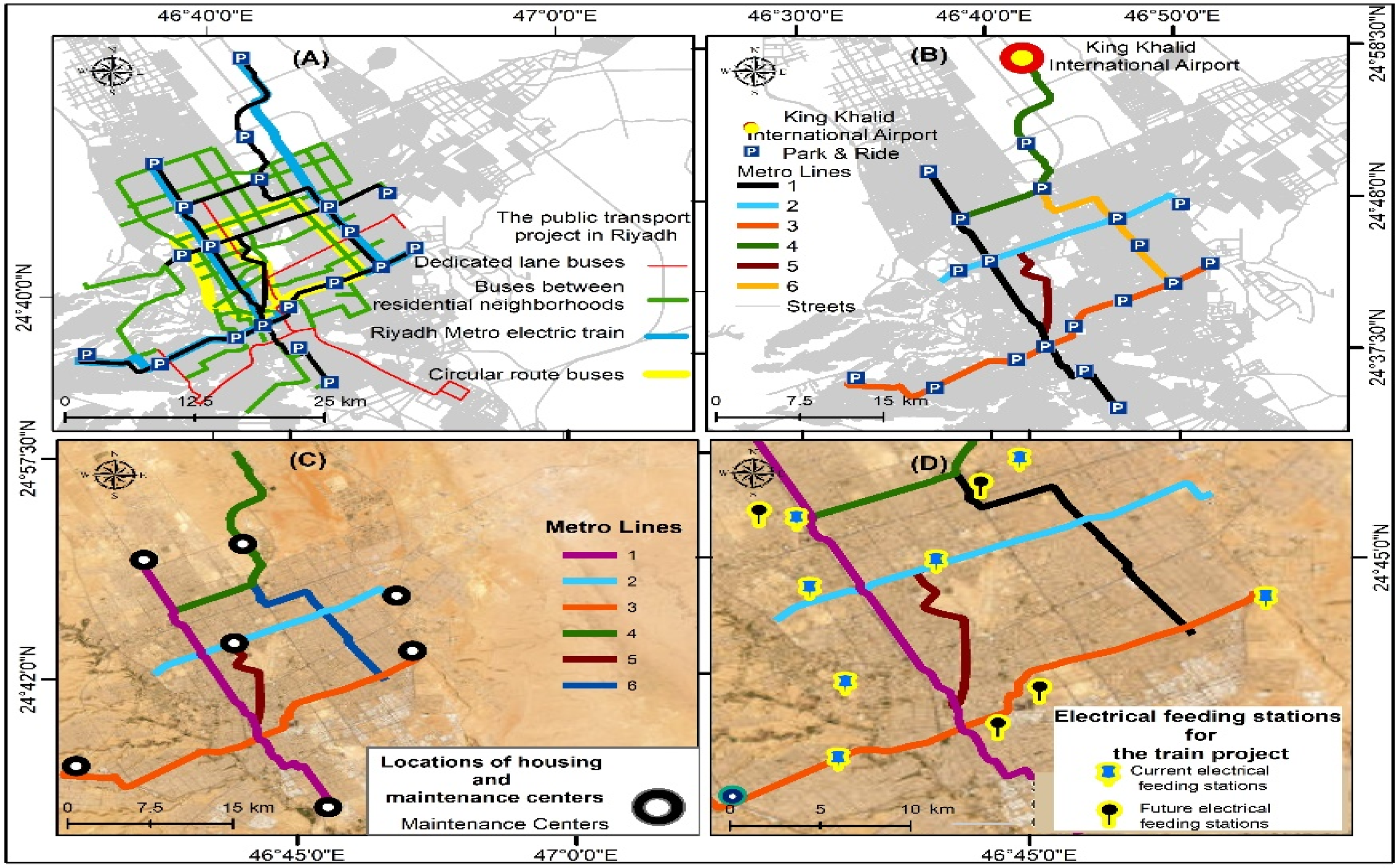
Figure 7 shows the parking facilities (car and bus) and public transport (B) in the city of Riyadh.
Figure 7.
Park and ride facilities (A) and public transportation (B). The image (C) shows the locations, housing and maintenance centers for the Riyadh Metro, and also the image (D) shows the electrical supply stations for the train project.
In Riyadh, a park and ride system has been placed very thoughtfully near metro stations. These sites were chosen for their high accessibility and great demand. At the same time, promoting the use of public transport, which in turn sees fewer private cars on the road and a drop in traffic, is of great importance for the environment. Also, security, including surveillance and proper lighting, has been designed, which adds to the convenience of the users. The result is enhanced access to the train system, a reduction in the use of personal vehicles, and, in turn, the growth of a more sustainable urban transportation system.
In the metro system, there is a network of electrical feeders that is used for constant train power. Eight stations are operational at present, while four are in the process of being added to the network; they play a key role in taking high-voltage power and turning it into the power trains use. Further, these facilities are at strategic locations along the metro lines, which in turn minimizes transmission loss and provides stable power, which is important for the safety and reliability of the system.
Train and infrastructure maintenance are performed at maintenance centers that have been strategically placed. These hubs are the backbone for inspection, repair, and preventive maintenance; they ensure that performance and safety are optimal. These centers have the best technology and staff, who look after mechanical, electrical, and electronic systems. They also manage the spare parts inventory and conduct overhauls. Moreover, the strategic location of the centers plays a key role in reducing downtime and increasing the system’s reliability and efficiency.
Riyadh has a large-scale bus network besides the metro; it improves residential transport with its four tiers of service. Tier 1 includes dedicated lane buses, which run on the main routes. In Tier 2, there are circular route buses that connect to key hubs. Tier 3 has arterial buses that link neighborhoods and those hubs, and in Tier 4, there are the local feeder buses that cover residential areas. What you also see is a focus on efficiency, connectivity, and accessibility, which allows the network to integrate with the metro to meet the various travel needs around the city.
8. Analysis
8.1. Buffer Zones
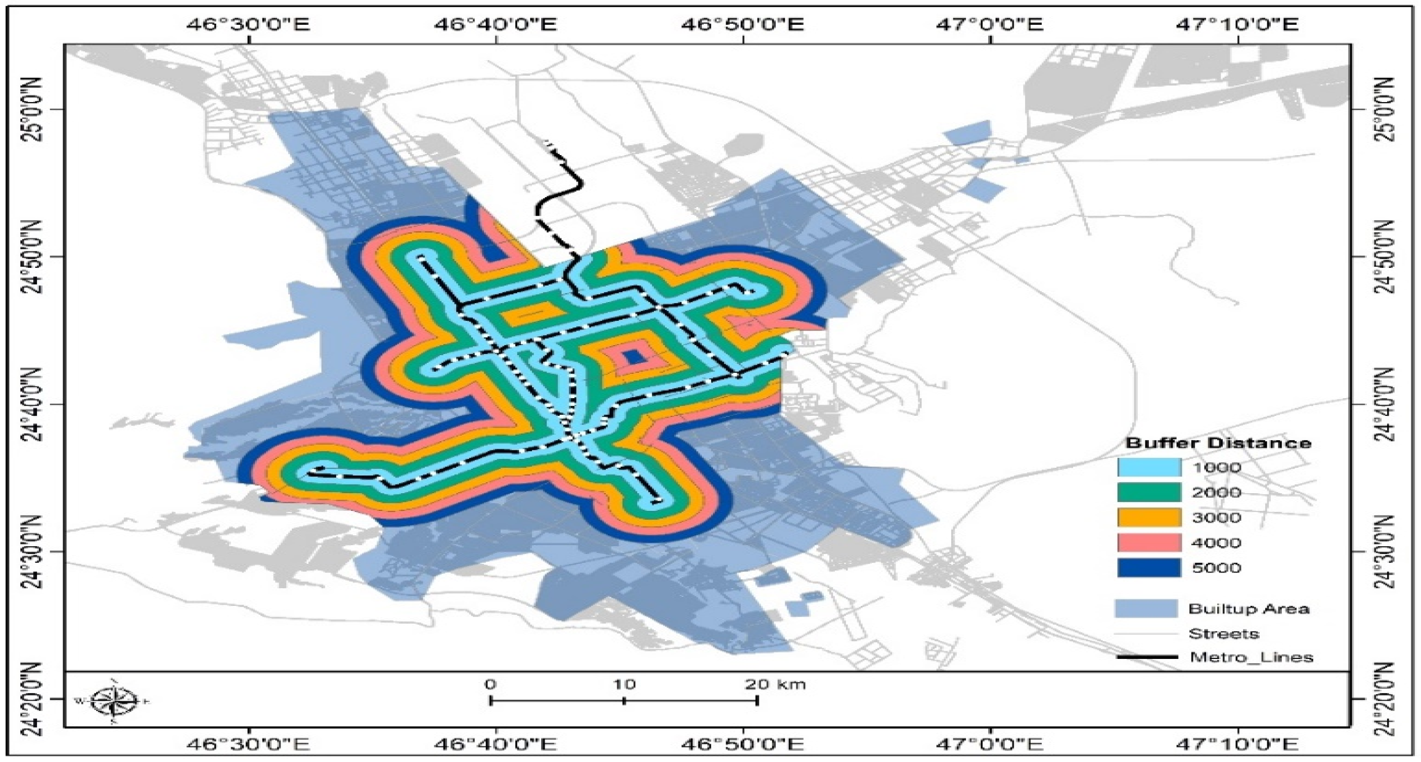
Previous figures presented a large set of data through an in-depth study of service coverage and access in the urban areas of Riyadh. This included a close look at the metro lines and the role they play in those areas. Barrier analysis was also carried out at 1000 m intervals up to 5000 m to see how access changes with distance from the metro network, which in turn provides important information for urban planning and transport management.
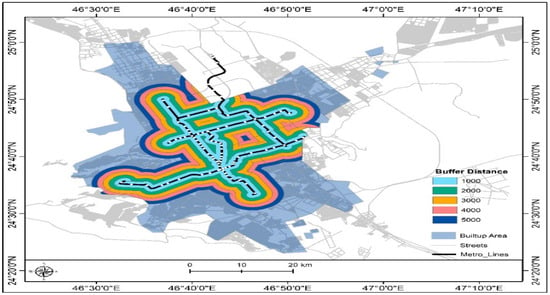
Figure 8 shows the Buffer zones around Riyadh metro lines in the study area, Riyadh City.
Figure 8.
Buffer zones around Riyadh metro lines in the study area, Riyadh City.
In the results reported, there is great coverage of developed areas that are close to metro lines. This means that large parts of the population have access to the metro. At the same time, the distance decay principle is present, as the coverage does indeed extend with an increase in distance from the node, but at the same time, the proportion within the built-up area goes down, which in turn presents issues related to access at greater distances from public transit.
While there has been great progress in terms of coverage, in the urban environment, there are still gaps of 5 km or more from the metro service. There are still some very persistent issues regarding metro access. These challenges may be due to physical barriers, a lack of supporting infrastructure, or large-scale socioeconomic issues that influence public transit access.
The area covered by the metro reached 1013.999 square kilometers, classified as served. An area of 896.530 square kilometers was assigned to the unserved category. This provides a picture of the service provision and which areas have poor transport access that needs to be improved.
This analysis brings into focus the difference between areas that are served and those that are not—a distinction which will provide very useful data regarding the demographic impact of access issues. This study also investigates land use in the unserved areas, which in turn will inform the development of targeted expansion of the metro network, as well as other transport options to improve access.
The study underscores the importance of considering social equity in service coverage distribution to ensure fair and comprehensive transportation access across diverse social groups within the urban community.
8.2. Land Use: Maps Depicting Commercial Land Use Around Train and Metro Lines
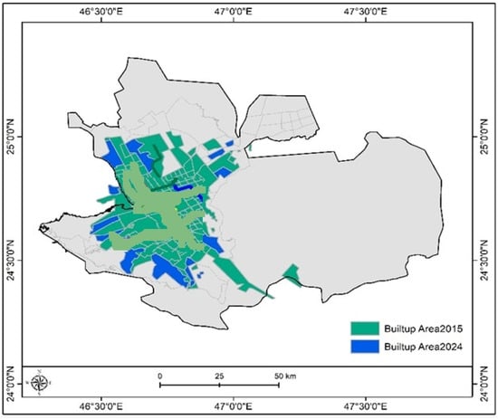
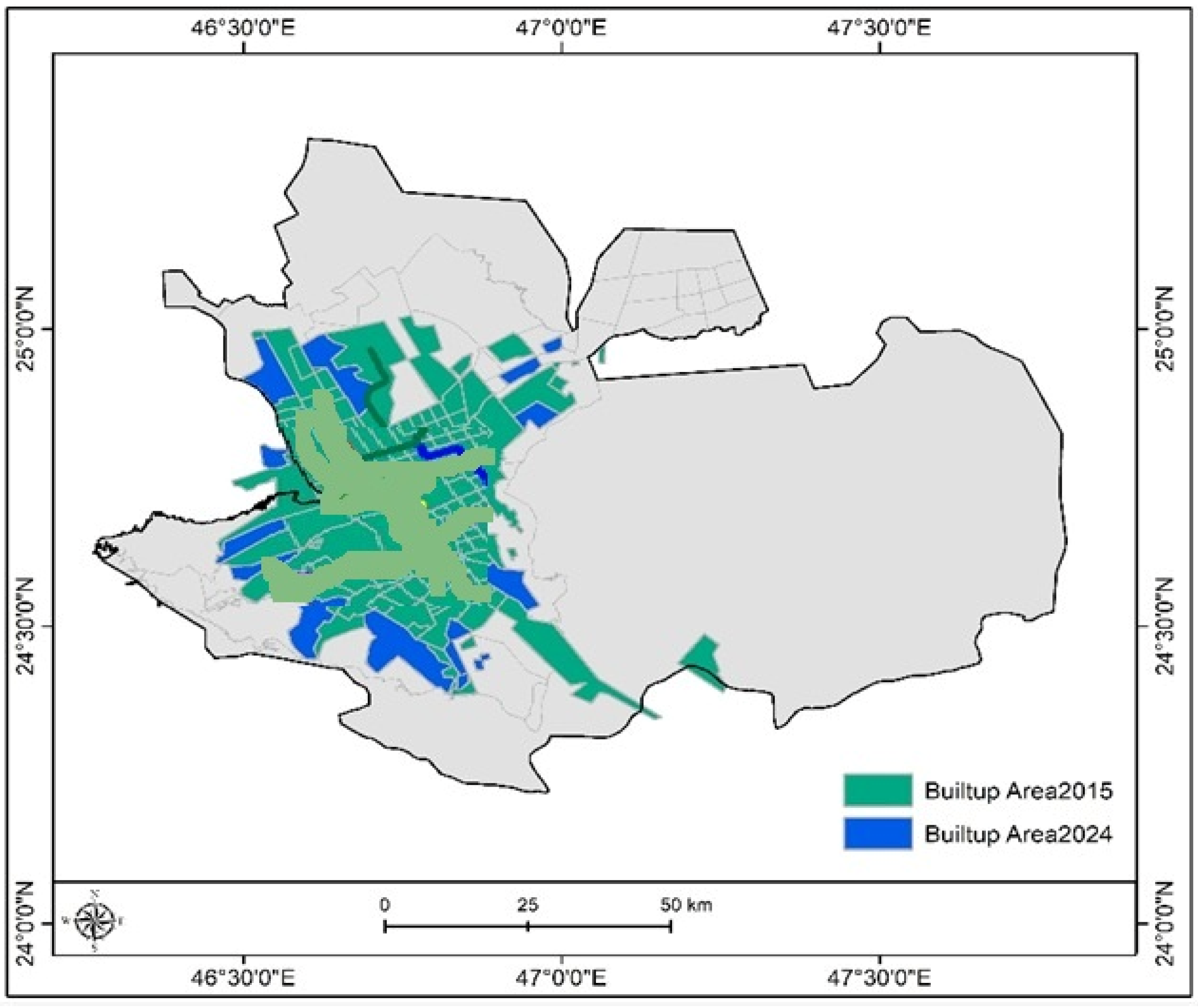
Surveying the period 2015–2024, this study looked at the growth of built-up areas in terms of metro station development that the earlier maps and tables reported. The provided table indicates that there is a large-scale increase in built-up areas during this time, which is of note, increasing from a built-up area of about 2040.94 square kilometers in 2015 to 2480.43 square kilometers by 2024. This is a large-scale development around metro stations. Also, there is a total of almost 439.49 km2, which is a significant change. In addition, there was significant continuous development during that time.
Figure 9 shows built-up areas 2015 and area 2024 in the study area, Riyadh City [Kingdom of Saudi Arabia].
Figure 9.
Built-up areas 2015 and area 2024 in the study area, Riyadh City [Kingdom of Saudi Arabia].
Table 1 shows the change in building area from 2015 to 2024.
Table 1.
Built-up area change from 2015 to 2024.
Metro station development has put in place better access and connections, which in turn have spurred economic growth and brought in population growth. What is noticed is an increase in economic benefits via the establishment of new businesses, residential areas, and support infrastructure, which are creating jobs and stimulating economic activity.
In the move toward urbanization, what was once underdeveloped land is being repurposed for urban growth that is of great scale, which puts forth very important issues related to land use and the environment. Also, looking at population growth as these changes play out provides a better picture of what social and economic results will result from metro development.
The growth of the urbanized area shows that the types of development—residential, commercial, or industrial—that are taking place are very informative as to how the cities are changing. It is essential to look at the environment’s response to this growth, which includes the improvement in air quality as a result of more green space and other environmental changes. This is key to sustainable urban development.
To conclude, despite the large-scale urban growth and economic development from metro station construction, which also brings about social changes, the long-term environmental and social impacts of this rapid urbanization must also be considered in order to push for sustainable development practices.
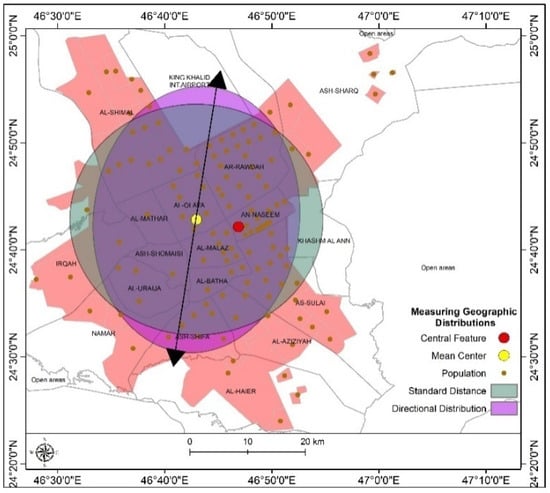
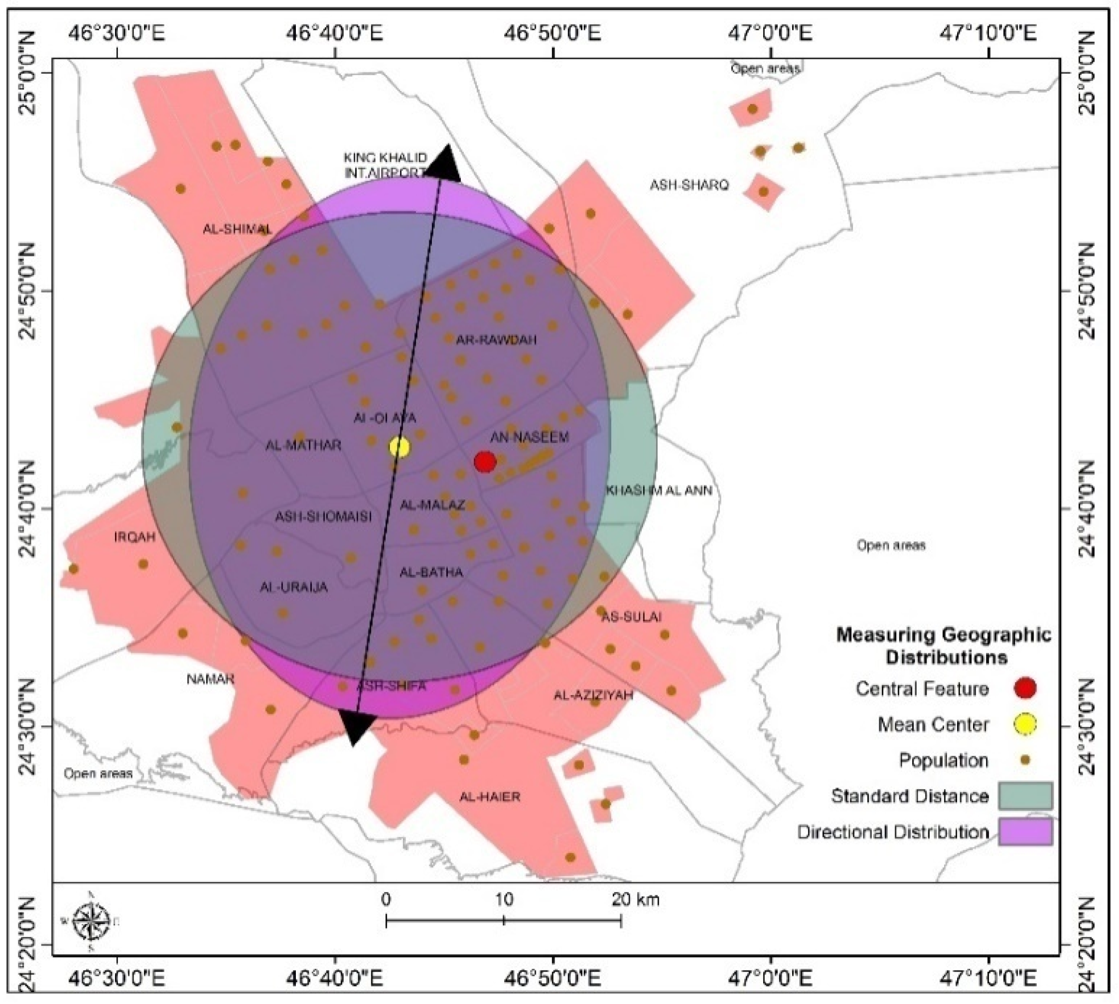
Figure 10 shows spatial analysis of population distribution in the study area
Figure 10.
Spatial analysis of population distribution in the study area. Source: Author’s drawing using ArcGIS10.8 and data from the General Authority for Statistics.
The image presents a detailed look at Riyadh, Saudi Arabia, with a focus on population distribution and key geographical features. The population is represented by orange dots spread out across the map. There are large groups in the city center and along the main transport routes. Also, what stands out is that the distribution is quite uneven, with some highly dense clusters that contrast with larger areas of low density.
In the case of the mean center, which is represented by a red dot that marks the average location of the population distribution, there is a point that also suggests a rather even population distribution. Further, there is a median center, which is indicated by a yellow dot that, in most cases, is a little way from the mean center. This point is what minimizes total travel distance to all the population points, although in some cases it may be influenced by outlying population clusters. The large purple circle around the mean center likely signifies the standard distance, visually highlighting the extent of population spread within a specific radius.
In the northwest, colored purple, there is a pattern of population distribution that may point to a trend of growth or movement in that direction.
In urban planning, the understanding of population distribution and its trends is key to the success of infrastructure development and resource allocation. This information is used to develop strategies for future growth, put health and education resources where they are most needed, and improve transport systems to reduce traffic. Also, mapping population distribution in relation to socioeconomic indicators brings to light issues of inequality and disparity within the city, which in turn aids in carrying out in-depth socioeconomic research.
In summary, this study focuses on population distribution and key features in Riyadh, Saudi Arabia. It suggests that this information enhances the base for better decision-making and plays a role in the development and growth of the city in a sustainable way.
8.3. Demographic Data: Population Census Data, Including Population Density
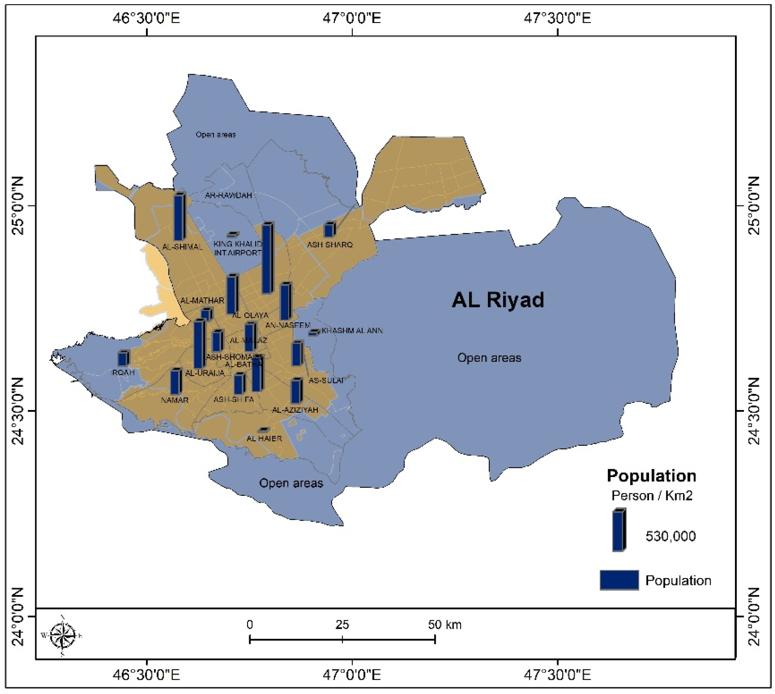
In Riyadh, Saudi Arabia, population distribution analysis presents the relationship between population density and metro stations. The maps and tables presented here are designed to provide insight into the various population patterns within the city and the role metro stations play in them.
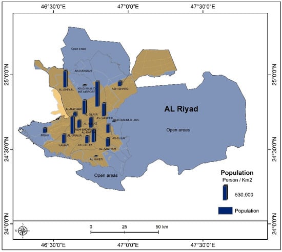
Figure 11 shows the Riyadh population distribution by district.
Figure 11.
Riyadh population distribution by district. Source: Author’s drawing using ArcGIS10.8 and data from the General Authority for Statistics [GaStat].
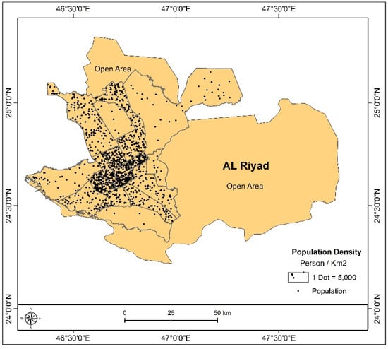
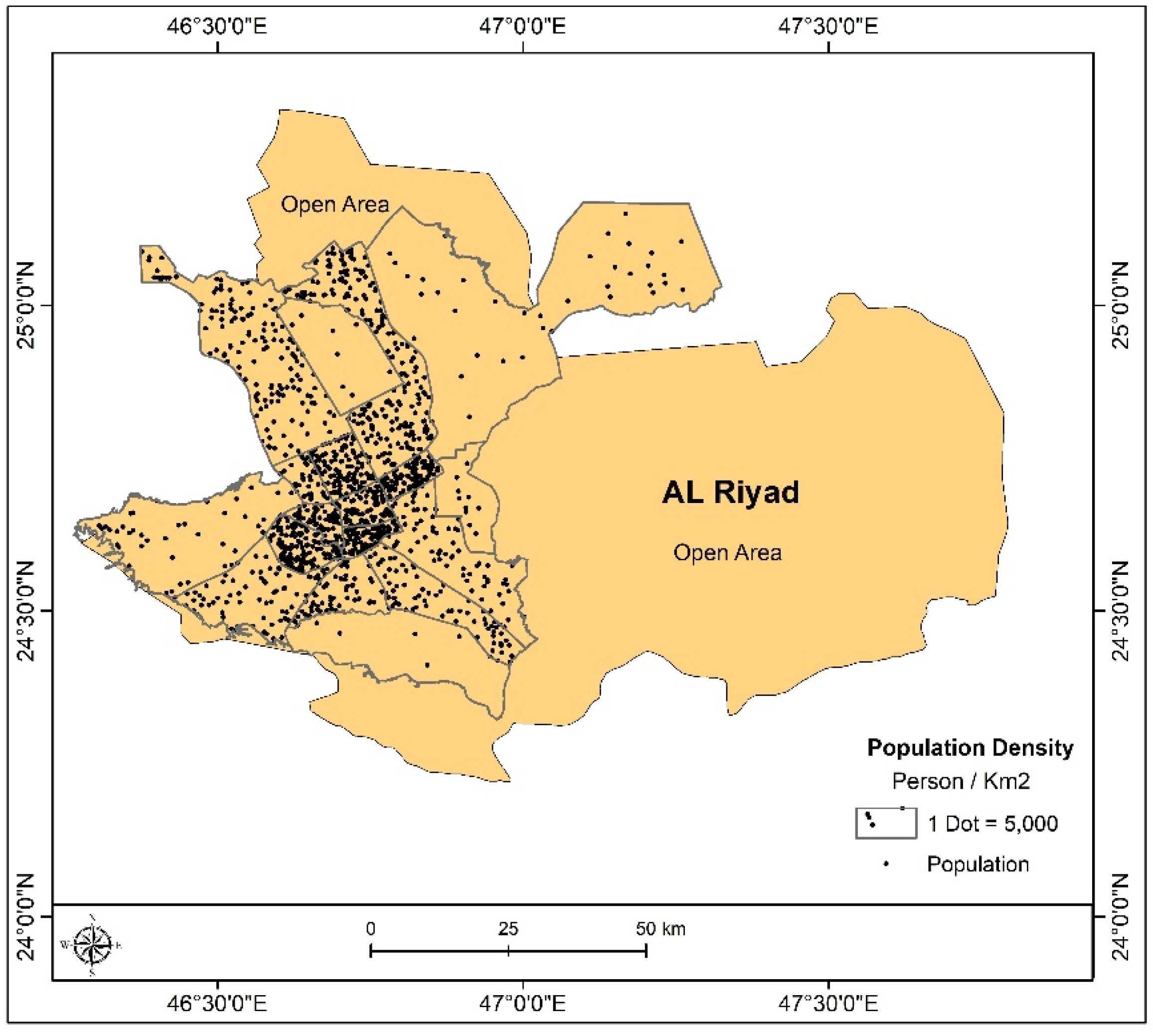
Figure 12 shows the population density in the study area, Riyadh City (Dot = 5000).
Figure 12.
Population density in the study area, Riyadh City. Source: Author’s drawing using ArcGIS10.8 and data from the General Authority for Statistics [GaStat].
In the first map, the main areas of high population density are in the city center, which includes neighborhoods like Al-Bathaa, Al-Olaya, and Al-Rawdah. Also, it is a trend that large groups of people live in major urban areas.
The table provides additional details on population density in each neighborhood, highlighting Al-Bathaa, Ar-Rawdah, and Al-Shimal as the most densely populated areas. The table includes data that breaks down population density by neighborhood—Al-Bathaa, Ar-Rawdah, and Al-Shimal report the highest numbers.
Metro stations can be linked to a rise in population density due to their access and mobility features. Also, it is clear that metro stations will shift travel choices from private vehicles to public transport. In terms of equity issues, there is a problem with access to metro stations. Moreover, there is the issue of integration with other transport options and the requirement for in-depth urban planning, which must address the different needs of the population and promote fair access.
In a nutshell, it is clear what metro stations have in store for the population of Riyadh and what they bring to the table in terms of growth. This presents a strong case for the integration of public transport and urban development into a sustainable and balanced urban environment.
8.4. Road Network: Data on Primary and Secondary Road Networks in the City Will Be Gathered
Riyadh’s metro service areas seem to be very telling in terms of how the metro project impacts the urban fabric of the city, which in turn affects residential communities.
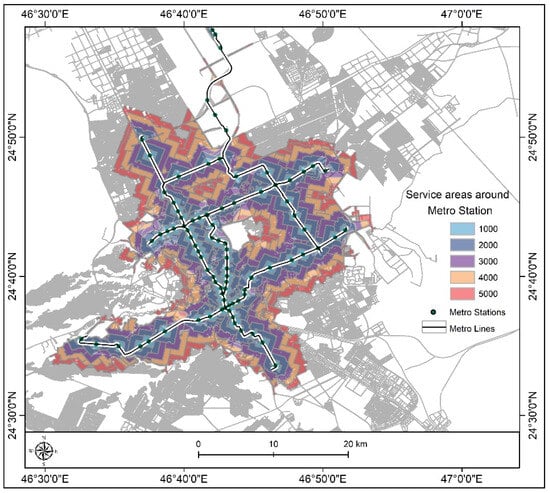
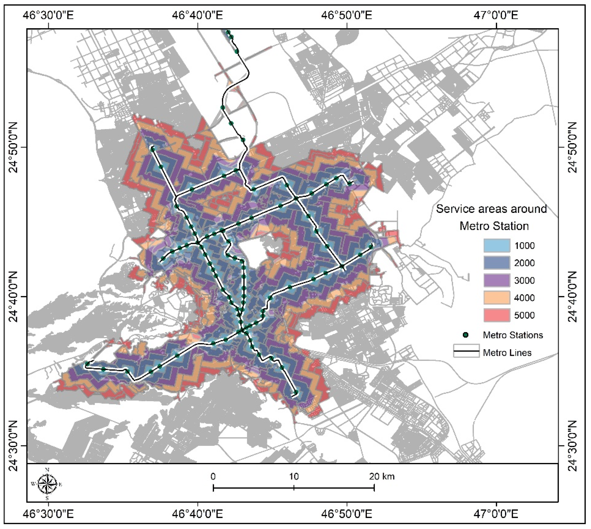
Figure 13 shows the service area distance around metro stations [1000–5000] m in the study area, Riyadh City.
Figure 13.
Service area distance around metro stations [1000–5000] m in the study area, Riyadh City. Source: Author’s drawing using ArcGIS10.8 and data from the Riyadh Development Authority.
Table 2 shows the service area distance around metro stations [1000–5000] m in the study area, Riyadh City
Table 2.
Service area distance around metro stations [1000–5000] m in the study area, Riyadh City.
The maps and tables present a picture of the service areas around metro stations that is color-coded to indicate distance from the station [for example, 1000 m, 2000 m]. Also, these visuals do an important job of showing the distribution of metro stations and network lines seen in different areas of the city. There is a large concentration of stations in the city center, which also has high population density, and the network lines extend out to cover larger areas.
The table, which breaks down residential area coverage, shows that metro service areas cover 36.27% of the total residential area in the city. This is a large-scale impact of the project in terms of bringing public transit access to city residents. Service areas for each station vary in size, which is a reflection of population density and urban distribution. In high-density central areas, there are smaller service areas; in contrast, service areas extend farther in low-density regions.
In many ways, the metro project transforms residential communities. For one thing, it provides better access and mobility for city residents, which in turn reduces private vehicle use. Also, it brings about growth around metro stations, resulting in an increase in density and the development of mixed-use residential and commercial projects. In addition, property values in areas near metro stations have increased as a result of the increased demand for housing in those areas. Also, the project improves overall quality of life by reducing traffic jams and improving air quality through the provision of green transport options.
However, there are issues to solve. As for allowing different transport modes to work together, what is key is to put in place efficient bus services, which will tie remote residential areas into the main metro system. Also, attention must be paid to pedestrian and cycle routes around metro stations to promote active transport. There should also be sustainable urban design, including green spaces and energy efficiency measures that largely minimize environmental impact in areas that surround the metro stations.
To conclude, the Riyadh metro project is a large step in the development of the public transport system of the city and has a great impact on residential areas. For the benefits of the project to be maximized, there is a need for integrated transport planning, support in the development of infrastructure, and a commitment to sustainable urban development principles.
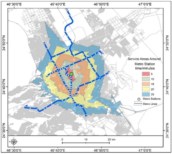
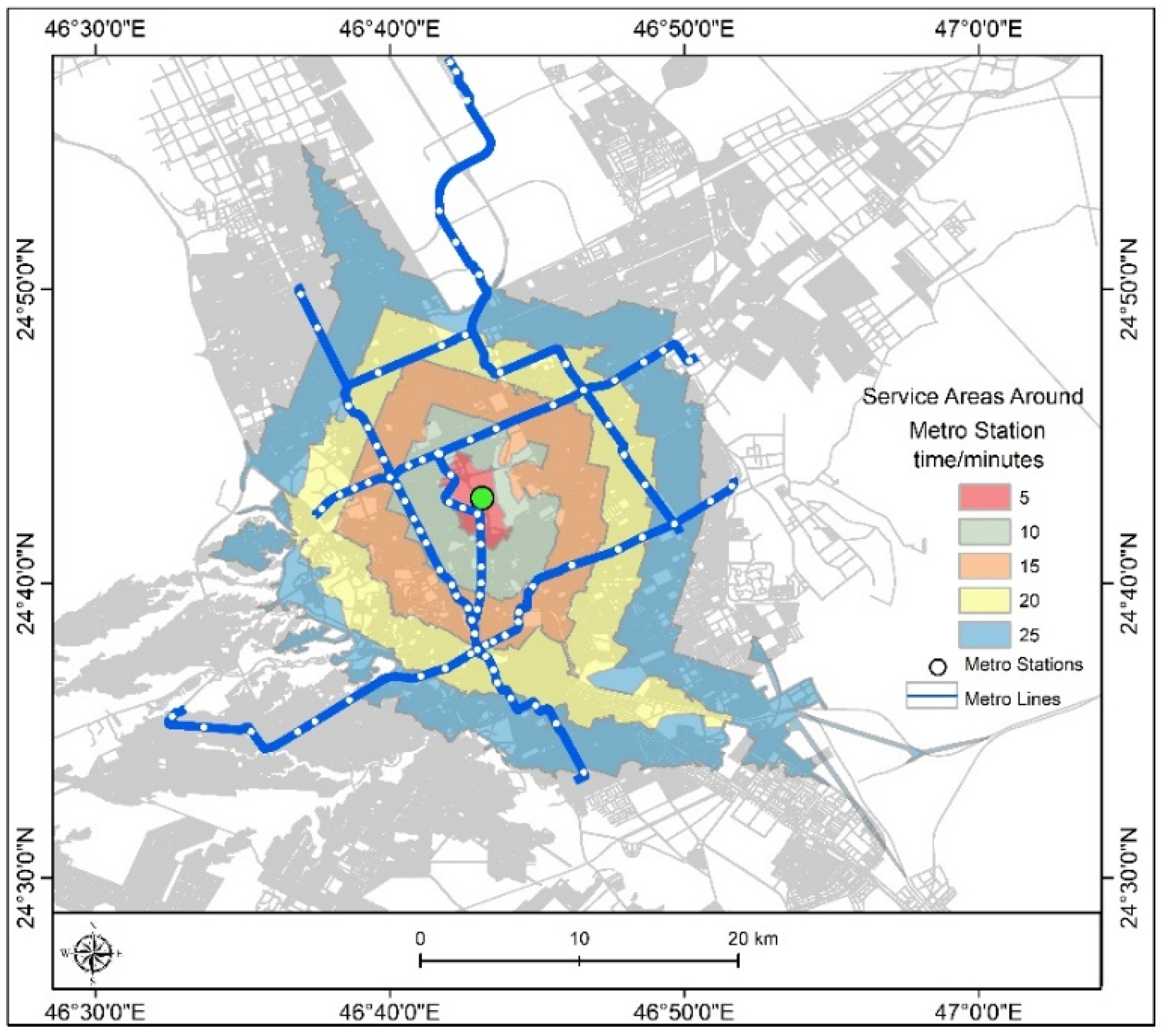
Figure 14 shows the service area times around metro stations [5–25] in minutes across the study area, Riyadh City.
Figure 14.
Service area times around metro stations [5–25] in minutes across the study area, Riyadh City. Source: Author’s drawing using ArcGIS10.8 and data from the Municipality of Riyadh.
This study shows the access times for metro stations in Riyadh, which in turn affect nearby residential areas. This in itself is a look into the very important role public transport infrastructure plays and how well it serves residents’ needs. Also, the study presents a full look at the data from the images and tables, which are used as a framework to show how access times play a role in passenger attraction, network operation, and the integration of transport modes.
In the image, there is a color gradient that represents service areas around Riyadh metro stations by access time, for example, 5 min and 10 min. Also shown is the layout of the metro stations and network lines, which are mainly in the central areas, with a few in the outlying regions. What is notable is that service area sizes are a function of access time near the stations [5 min access], which have small coverage, but as access time increases to 20 and 25 min, the areas covered grow larger.
Table 3 shows the service area time around metro stations [5–25] in minutes in the study area, Riyadh City.
Table 3.
Service area time around metro stations [5–25] in minutes in the study area, Riyadh City.
The table shows residential areas covered by the Riyadh metro stations over various time frames. It shows that the areas that are accessible within 25 min only make up 6.50% of the total residential area in the city. This underlines the issue of improving network coverage and reducing access times in order to serve a larger group of people. Also, it shows that at the 5 min mark, only a small percentage of residential areas are included, which increases as access time increases. Access time is a key factor in passengers’ choice to use the metro. It is shown that shorter access times improve the metro’s appeal as a very efficient and convenient transit option. They also play a role in how well the metro system operates—with shorter access times, there are faster trains and increased network capacity. Moreover, access time is an issue in the integration of different transport modes, which is important. Residents in outlying areas may use feeders like bus services to travel to the metro, which in turn affects total travel time.
To deal with the issues at hand, the metro network should be expanded into residential areas, train frequency should be increased, and the integration with other transport options should be improved. By doing this, the development of a better and more sustainable public transport system is made possible, which truly serves the needs of Riyadh’s residential communities.
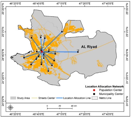
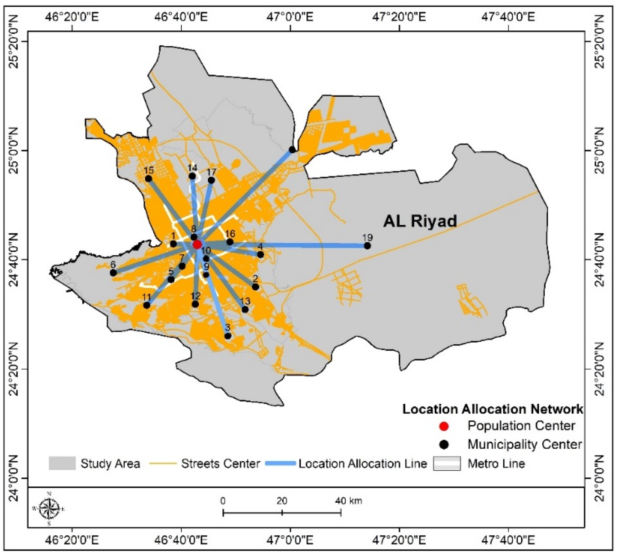
Figure 15 shows the location allocation from the city center to the municipality center within the study area.
Figure 15.
Location allocation from the city center to the municipality center within the study area. Source: Author’s drawing using ArcGIS10.8 and data from the Municipality of Riyadh.
Table 4 shows the location allocation from the city center’s population to the municipality center.
Table 4.
Location allocation from the city center’s population to the municipality center.
Looking at the access times for metro stations in Riyadh and the impact they have on residential areas in fact provides information on the key role public transport infrastructure plays, and how well it is performing in terms of what it provides for the community. Also, the in-depth information in the figures and the tables provides a model that looks at how access times play a role in passenger attraction, network operation efficiency, and transportation mode integration. This study presents data that have been estimated for the total travel distance from the heart of Riyadh City [Location 1] to 19 other municipal centers [Locations 2–19], which in turn provides an idea of the approximate travel times based on assumed traffic speeds. For example, using an average speed of 80 km/h, Location 2, at a distance of about 26.8 km from the city center, reports an arrival time of 21 min. At the other end of the scale, Location 18, which is some 49.8 km away, reports a travel time of almost 40 min. These data show a large variation in travel times between the various municipal centers and the city center, which in turn points to issues of access in more remote areas. Also, there is a great need to build better infrastructure, in particular for transport networks, to fix these issues and to improve connections. It is recommended that authorities expand public transport systems, improve road infrastructure, develop smart transport solutions, and encourage the use of other transport options. By integrating these strategies, this study indicates that there can be an improvement in mobility efficiency, a reduction in congestion, and eventually an enhanced quality of life for residents as the city works toward its sustainability goals.
In Riyadh, the analysis of travel times to municipal centers is a useful tool for city planners and developers. In that regard, this study suggests that a focus on better access and shorter travel times will see an improvement in the quality of life for residents as well as the achievement of sustainable development goals.
8.5. Spatial Analysis to Identify Hotspots
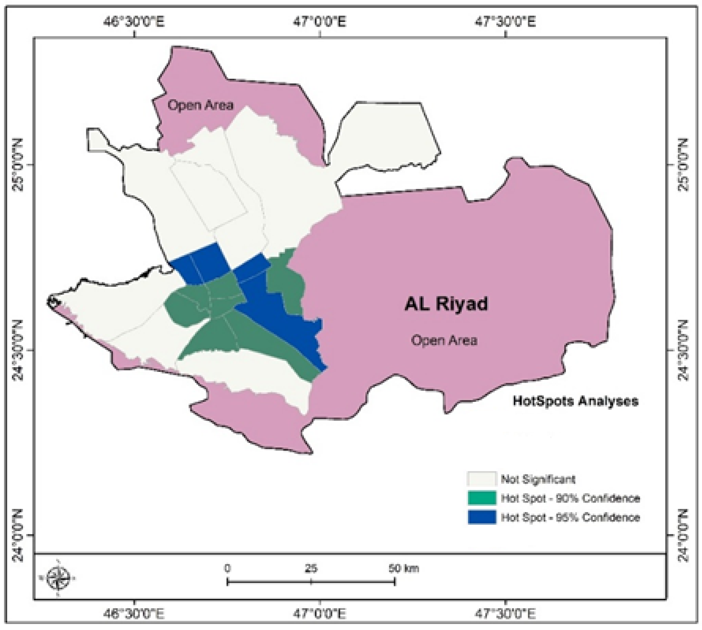
In this study, areas of high [hot spots] and low [cold spots] local population density are presented. In the hot spots, there are dense population groupings that are dark blue and dark green in color; they are in the city center as well as some surrounding regions. The cold spots are gray; these indicate low density and are found at the edges of the city and also in the nearby desert regions. Also, there are areas in pink, which are areas that do not have large-scale population groupings. For the Riyadh metro project, this is a great tool to use in the planning and design of the metro network. Focusing on growth in the hot spots will better serve the dense population and ease traffic issues. Further, this helps to determine the best station locations that are close to population clusters and thus will better serve the people. Also, it can be used to look at how the project will work in terms of population shift and in deciding which areas will see an increase in population near metro stations. Hence, this is a very useful tool for investigating growth and service improvements for the Riyadh metro network, which in turn will support future expansion and better service for the city’s residents.
Figure 16 shows the hot and cold spot analysis of population distribution in Riyadh
Figure 16.
Hot and cold spot analysis of population distribution in Riyadh. Source: Author’s drawing using ArcGIS10.8 and data from the Municipality of Riyadh.
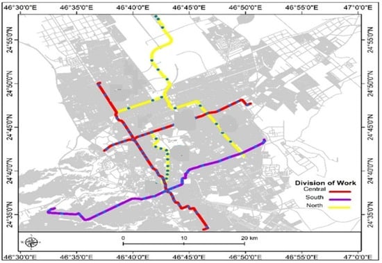
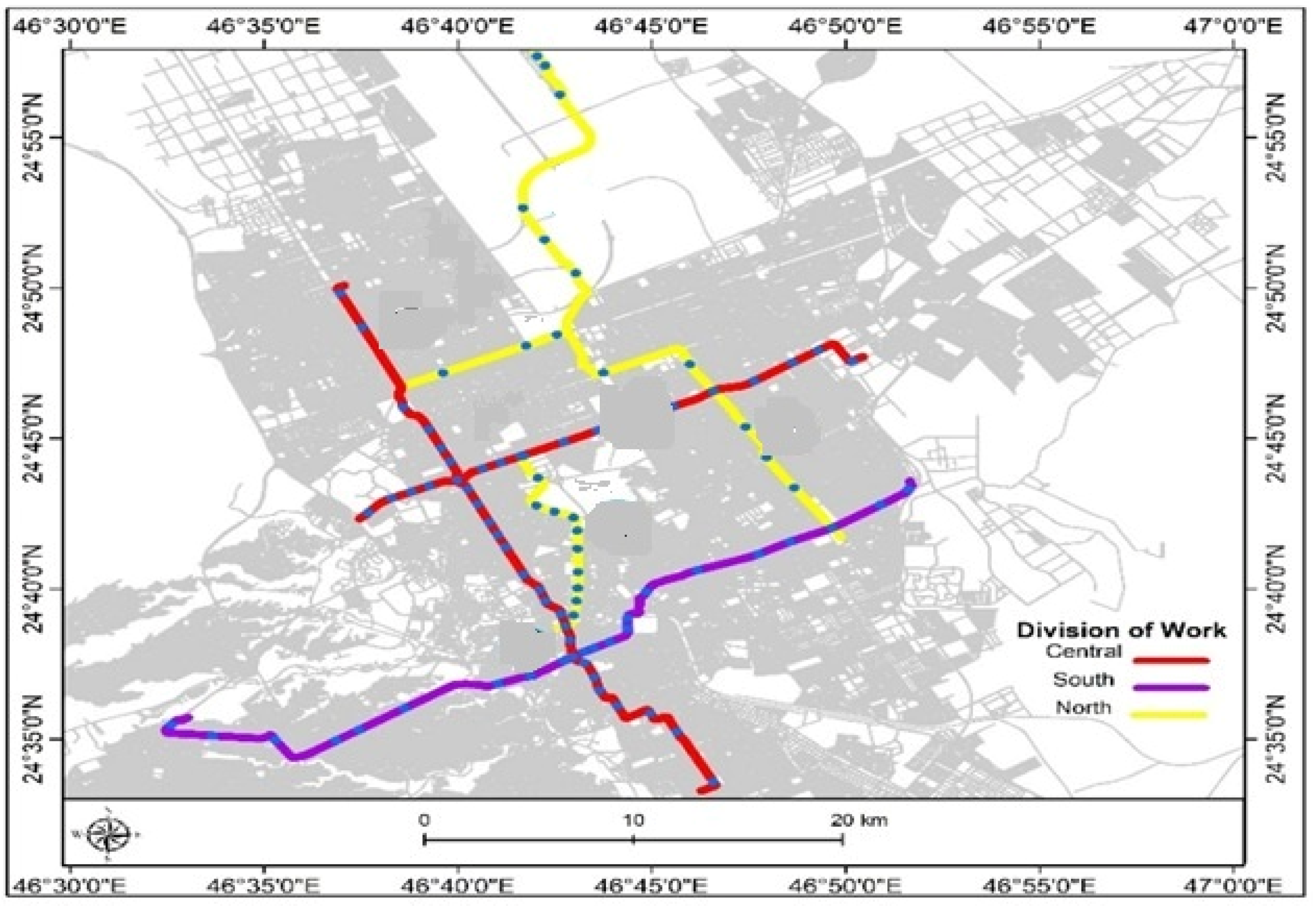
Figure 17 shows the division of the metro project into three groups according to tracks in Riyadh City.
Figure 17.
Division of the metro project into three groups according to tracks in Riyadh City.
9. Results and Discussion
Evaluation of the Public Transportation Project in Riyadh
- 1.
- Service coverage analysis:
- Service area analysis indicates that the metro and bus network covers a significant portion of residential areas in Riyadh, but some areas remain underserved, especially in the city’s outskirts.
- Travel time to metro stations varies by region, with longer travel times in areas farther from the city center.
- Emphasis should be placed on expanding the public transportation network and improving connectivity to provide comprehensive coverage and enhance accessibility for all residents.
- 2.
- Land use analysis:
- Areas surrounding metro stations have witnessed a noticeable increase in urban and commercial development, indicating a positive impact of the project on economic growth.
- Sustainable land use planning around stations is essential, with allocations for green spaces and public facilities.
- 3.
- Population density analysis:
- High population density is concentrated in the city center and some surrounding areas, underscoring the importance of efficient public transportation services in these areas.
- The metro project may lead to increased population density around stations, necessitating integrated urban planning to meet the needs of the growing population.
- 4.
- Road network analysis:
- Travel time analysis reveals significant variations in travel times to municipal centers from the city center, highlighting the need to improve road infrastructure in distant areas.
- The metro project can contribute to reducing traffic congestion on main roads, but it should be integrated with an effective road network to provide comprehensive transportation solutions.
- 5.
- Vegetation coverage analysis:
- Despite Riyadh’s arid climate, pockets of moderate vegetation exist in the central area of the city and some urban areas.
- Some areas have experienced a slight increase in vegetation cover between 2015 and 2024, indicating urban greening efforts and sustainable development projects.
- The metro project can support environmental sustainability efforts by encouraging sustainable urban growth around stations and increasing green spaces.
- 6.
- Hot and cold spot analysis:
- Hot spots with high population density are concentrated in the city center and some surrounding areas, while cold spots are in the outskirts and surrounding desert areas.
- This analysis explores which areas have the greatest need for growth, the issues related to station development that require attention, and how the project as a whole will transform population distribution.
The King Abdulaziz Public Transport Project is a significant step towards improving Riyadh’s transportation system and achieving environmental, economic, and social sustainability goals.
- The project contributes to alleviating traffic congestion, improving air quality, enhancing economic growth, and enhancing residents’ quality of life.
- Emphasis should be placed on expanding the public transportation network, improving its integration, and providing comprehensive services to meet the needs of all segments of society.
- Sustainable land use planning around stations, with allocations for green spaces and public facilities, is essential.
- Investment in improving road infrastructure in distant areas is necessary to ensure better accessibility and reduce the gap between the city’s outskirts and its center. The metro project can play a role in supporting environmental sustainability efforts by encouraging sustainable urban growth around stations and increasing green spaces.
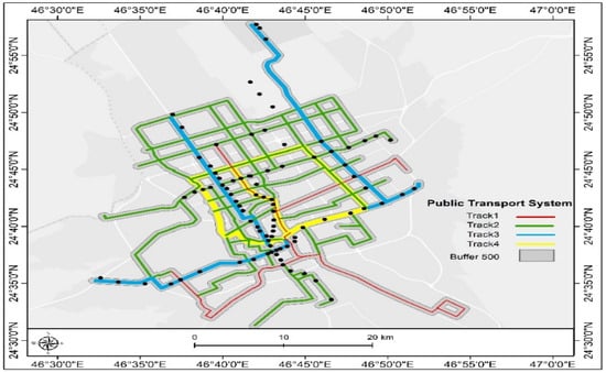
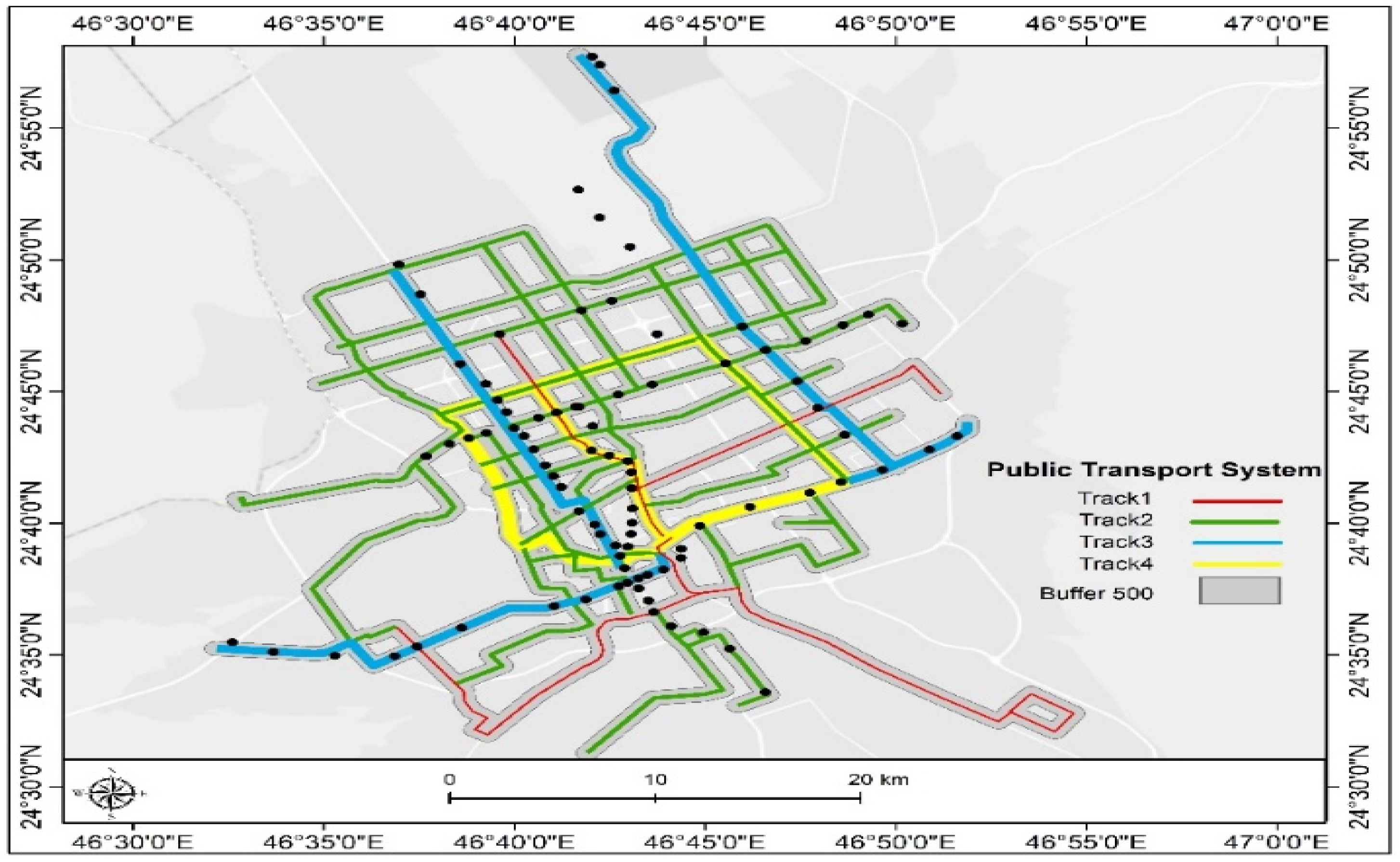
Figure 18 shows the analyzing service coverage [buffer zone 500 m] around public transportation routes in Riyadh.
Figure 18.
Analyzing service coverage [buffer zone 500 m] around public transportation routes in Riyadh. Source: Author’s drawing using ArcGIS10.8 and data from the Riyadh Development Authority.
Analyzing Service Coverage around Public Transportation Routes in Riyadh
The picture shows the public transport network, which includes four primary bus routes [Track 1, Track 2, Track 3, Track 4], and the outlying developed areas are also shown. In addition, the study investigates the value of looking at service coverage around public transport routes, which in turn provides details on how well these services perform in the nearby areas.
A 500 m-wide zone has been created around each of the bus routes, which identifies the close and practical walking distance to bus stops. That buffer zone, in effect, is the primary service area of the bus network that, in turn, provides residents with easy access to the stations without the use of other transport options.
This study used GIS for spatial analysis and found that, out of a total of 456.338 square kilometers, which is the buffer zone around the four bus routes, a large proportion of the built-up areas in Riyadh are within the public transport’s service coverage range. This facilitates residents’ use of the bus network for daily travel.
In terms of service coverage, it is key to determine how well a public transportation network performs. This can identify gaps requiring improved services or additional stations to which greater numbers of residents will have access. Also, it is important to investigate how public transport utilization can be maximized by improving pedestrian and bike routes and the development of park and ride facilities, which encourage the use of public transport over private cars.
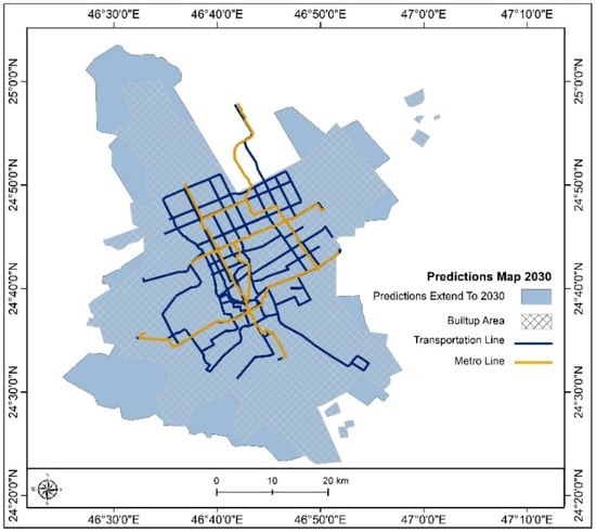
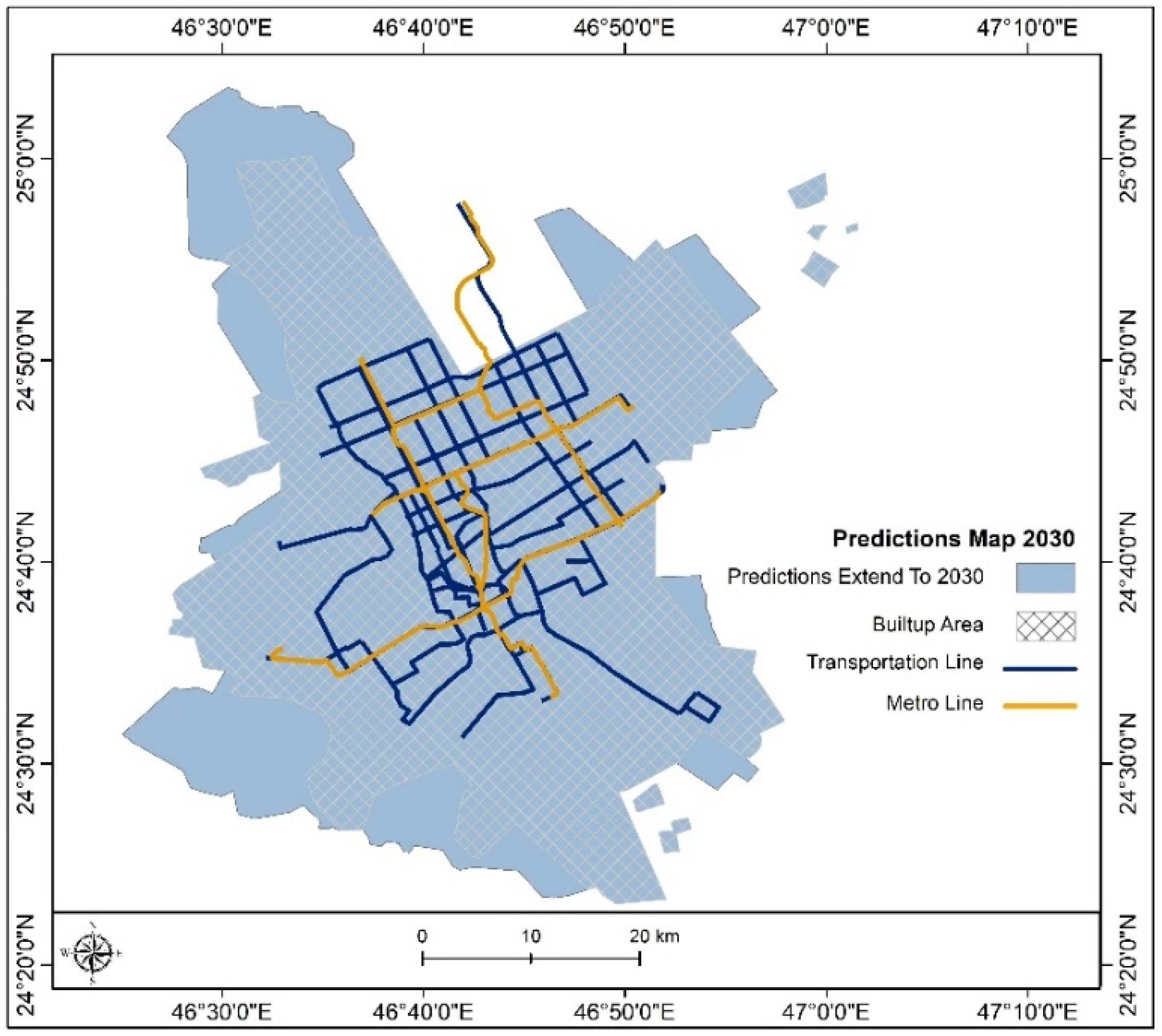
Figure 19 shows the future expansion of the Riyadh Public Transport Network: Reaching New Horizons [2030].
Figure 19.
Future expansion of the Riyadh Public Transport Network: Reaching New Horizons [2030].
Future Expansion of the Riyadh Public Transport Network: Reaching New Horizons [2030]
The Riyadh Public Transport Project has put forth a very lively and changing network that is growing with the city’s increasing transport needs. By 2030, the project may have grown greatly, by adding 2435.384 square kilometers to its present reach. This expansion will see the extension of metro lines and bus routes to present void areas, mainly in the outskirts and suburban areas, which at present are underserved, thus improving connection and access for a larger population. Also, the planned expansion will play a key role in the city’s projected growth in population, in the reduction of traffic jams, and in the promotion of sustainable urban development. By taking services to new areas, the Riyadh Public Transport Project aims to put in place very efficient and reliable transport options, which will give all residents equal access and will eventually create a more connected and sustainable future for Riyadh.
Added Value of the Riyadh Public Transport Project
In the case of the Riyadh Public Transport Project, there are many benefits that go beyond basic transport. It plays a role in making the city more sustainable, efficient, and livable in many ways.
- 1.
- Economic benefits:
- Increased productivity: Reduced commute times lead to increased productivity for individuals and businesses.
- Economic growth: Improved accessibility attracts businesses and investments, stimulating economic development.
- Job creation: The project creates jobs in the construction, operation, and maintenance of the transport system.
- 2.
- Social benefits:
- Enhanced mobility: Provides equitable access to transportation for all residents, regardless of income or social status.
- Improved quality of life: Reduces stress and improves health outcomes by decreasing traffic congestion and air pollution.
- Social inclusion: Promotes social interaction and community building by connecting people from diverse backgrounds.
- 3.
- Environmental benefits:
- Reduced emissions: Decreases air pollution and greenhouse gas emissions by promoting the use of public transport over private vehicles.
- Improved air quality: Contributes to a healthier environment with cleaner air and reduced respiratory problems.
- Sustainable urban development: Encourages compact and walkable urban development, reducing reliance on cars and promoting sustainable land use practices.
- 4.
- Additional benefits:
- Reduced traffic congestion: Alleviates traffic congestion, leading to smoother traffic flow and shorter travel times.
- Enhanced safety: Provides a safer mode of transportation compared to private vehicles, reducing traffic accidents and fatalities.
- Technological advancement: Introduces modern technology and infrastructure, fostering innovation and progress in the transportation sector.
The Riyadh Public Transport Project is a transformative initiative that delivers a multitude of benefits, contributing to a more sustainable, efficient, and livable city for all.
10. Sustainability
In 2030, Saudi Arabia aims to report a 278-million-ton reduction of CO2 equivalent in annual greenhouse gas emissions through its Nationally Determined Contributions, which it has put forth under the UNFCCC. As part of many of its policies, the Kingdom seeks to develop a mass transit system and promote public transport-oriented development in Riyadh has a way to reduce energy use and greenhouse gas emissions. Also included in these reports are plans to promote mass transit in Saudi Arabia’s other cities.
In the Middle East, the Riyadh metro project is a forerunner in sustainable urban transport. It aims for efficiency and environmental consciousness, which is the focus of this innovative project, with the intention of transforming urban mobility. By putting forward clean and reliable options compared to cars, the metro system is reported to have achieved large reductions in carbon emissions, which play a role in the reduction of urban heat island effects, in the fight against global warming, and in the better health of the environment for all. Also, the project includes six wide lines that cover the whole city and also improve connectivity, reduce traffic jams, and, as a result, build a more sustainable and healthier urban environment for future generations.
Furthermore, the design of the metro stations sets a new standard for environmentally friendly infrastructure. At each station, sustainability features, including energy and water conservation, improved indoor air quality, the use of local materials, and waste recycling, have been incorporated. Green materials that have low VOC emissions have also been used. Also, the project has included renewable energy sources, such as photovoltaic cells, for environmental sustainability. In the case of Line 3 at the western depot, 5448 square meters of photovoltaic panels were installed to produce 30% of the facility’s energy. This is a large-scale embodiment of innovation and environmental responsibility. Finally, in terms of support structure, there are parking facilities, bus depots, a control center, and the Riyadh bus terminal.
How do sociodemographic factors shape public transportation?
Socioeconomic status significantly influences public transport choices. Low-income groups, who often lack private cars, rely heavily on affordable public transport options that suit their limited means. However, their experience is frequently marred by service deficiencies, leading to frustration and decreased ridership. The socioeconomic factors that significantly impact public bus usage can be summarized as follows: age, income level, gender, education, residential location, and others. Policymakers and service providers must understand how these factors affect public transport to help improve public bus services to better meet community needs. Research indicates that bus users are predominantly young, and this demographic is more likely to rely on public transport due to limited financial resources and a need for accessible transportation options. Passengers’ educational level also influences their perception and use of public bus services.
It is assumed that many highly educated individuals have better job prospects, leading them to prefer private transport over buses. Income is another crucial factor influencing the use of public bus services, with lower-income groups tending to rely more heavily on public transport for their daily commuting needs. Studies have shown that perceptions of service quality among these groups are often marginalized, indicating a high reliance on buses despite dissatisfaction with service characteristics. The relationship between income level and reliance on public transport is further confirmed by the fact that individuals in higher income brackets tend to prefer private vehicles, thus reducing their reliance on bus services. Socio-demographic factors are also key considerations in improving public bus services, with specific criteria such as age, income, gender, education, and geographic location collectively shaping bus usage dynamics in the city. Given the ongoing challenges facing the public transport system, addressing these factors through targeted policies and service improvements will be essential to enhancing public transport efficiency and user satisfaction.
To address these disparities, policymakers should prioritize crime prevention through environmental design by upgrading bus stops with high-intensity lighting and transparent monitoring features to alleviate car owners’ safety concerns and modernize public transport infrastructure. These enhanced crime prevention measures through environmental design primarily aim to address the low safety levels of users of alternative transport, such as car owners and working professionals, to encourage a more effective shift to alternative modes of transport. The goal is to achieve a safe, professional, and digitally integrated network where all segments of society can use public transport as a competitive alternative to private car ownership, ensuring that the majority of today’s youth remain regular users of public transport and achieving greater efficiency, security, and privacy.
Discussion
The King Abdulaziz Public Transport Project is a significant step toward improving Riyadh’s transportation system and achieving environmental, economic, and social sustainability goals. It will contribute to alleviating traffic congestion, improving air quality, boosting economic growth, and enhancing the quality of life for residents. Sustainable landuse planning around the stations, with the allocation of green spaces and public facilities, is essential. Furthermore, investing in improved road infrastructure in outlying areas is crucial to ensure accessibility, reduce the gap between the city’s suburbs and center, and achieve greater efficiency and equity among residents. The metro project can also support environmental sustainability efforts by encouraging sustainable urban growth around the stations and increasing green spaces.
Funding
This work was funded by the University of Jeddah, Jeddah, Saudi Arabia, under grant No. (UJ-24-DR-456-1). Therefore, the authors thank the University of Jeddah for its technical and financial support.
Institutional Review Board Statement
Not applicable.
Informed Consent Statement
Not applicable.
Data Availability Statement
The data that supports the findings of this study are available from the author upon reasonable request.
Conflicts of Interest
The author declares no conflicts of interest.
References
- Kussl, S.; Wald, A. Smart mobility and its implications for road infrastructure provision: A systematic literature review. Sustainability 2022, 15, 210. [Google Scholar] [CrossRef] [Scilit]
- Alotaibi, O.; Potoglou, D. Introducing public transport and relevant strategies in Riyadh City, Saudi Arabia: A stakeholders’ perspective. Urban Plan. Transp. Res. 2018, 6, 35–53. [Google Scholar] [CrossRef] [Scilit]
- Rinchi, O.; Alsharoa, A.; Shatnawi, I.; Arora, A. The role of intelligent transportation systems and artificial intelligence in energy efficiency and emission reduction. arXiv 2024, arXiv:2401.14560. [Google Scholar]
- Oakil, A.T.; Anwar, A.M.; Alhussaini, A.; Al Hosain, N.; Muhsen, A.; Arora, A. Urban transport energy demand model for Riyadh: Methodology and a preliminary analysis. Urban Plan. Transp. Res. 2022, 10, 253–273. [Google Scholar] [CrossRef] [Scilit]
- Al Zohbi, G. Sustainable transport strategies: A case study of Riyadh, Saudi Arabia. E3S Web Conf. 2021, 259, 02007. [Google Scholar] [CrossRef] [Scilit]
- Alfouri, A.; Alfouri, S. Artificial Intelligence in Medicine and Sustainable Development. Vet. Med. Public Health J. 2025, 6, 105. [Google Scholar] [CrossRef] [Scilit]
- Oladimeji, D.; Gupta, K.; Kose, N.A.; Gundogan, K.; Ge, L.; Liang, F. Smart transportation: An overview of technologies and applications. Sensors 2023, 23, 3880. [Google Scholar] [CrossRef] [Scilit] [PubMed]
- Ali, A.; Salameh, A.A. Role of travel and tourism sector in the attainment of Vision 2030 in Saudi Arabia: An analytical study. Probl. Perspect. Manag. 2021, 19, 276–290. [Google Scholar] [CrossRef] [Scilit]
- Almujibah, H.; Elamary, A.; Alwetaishi, M. Seeking ways for dealing with the impacts of sandstorms on the railway network in Saudi Arabia. Sustainability 2022, 14, 9436. [Google Scholar] [CrossRef] [Scilit]
- Almatar, K.M. Investigating the new public transportation system in Riyadh city. J. Urban Plan. Dev. 2024, 150, 05023051. [Google Scholar] [CrossRef] [Scilit]
- Al Fouri, A.; Sakher, S. Artificial intelligence on the smart city. Remit. Rev. 2023, 8, 4197–4210. [Google Scholar]
- Aldakkhelallah, A.A.A.; Shiwakoti, N.; Dabic, T.; Lu, J.; Yii, W.; Simic, M. Public opinion survey on the development of an intelligent transport system: A case study in Saudi Arabia. AIP Conf. Proc. 2022, 2681, 020089. [Google Scholar] [CrossRef] [Scilit]
- Alfauri, M.; Al Fouri, A. The role of geographic information systems in disaster management: A case study of covid-19 pandemic in Madaba governorate (Jordan). J. Res. Adm. 2024, 6, 6695–6708. [Google Scholar]
- Dahim, M.A. Challenges and opportunities in development sustainable transportation system in Saudi Arabia. Appl. Eng. Technol. 2023, 2, 34–45. [Google Scholar]
- Altuwaijri, H.A. Morphometric network drainage analysis for railway location: Case study of Saudi Railway Company’s project. Arab. J. Geosci. 2019, 12, 508. [Google Scholar] [CrossRef] [Scilit]
- Porcinari, M.G. Street, road, and boulevard: Permeable, smart, and creative systems transforming Riyadh. In Materials Research Proceedings; Materials Research Forum; LLC: Millersville, PA, USA, 2025; Volume 48. [Google Scholar]
- Lv, Z.; Shang, W. Impacts of intelligent transportation systems on energy conservation and emission reduction of transport systems: A comprehensive review. Green Technol. Sustain. 2023, 1, 100002. [Google Scholar] [CrossRef] [Scilit]
- Alamri, S. Spatial analysis and GIS mapping of public parks adequacy: A case study from Riyadh, Saudi Arabia. Sustainability 2024, 16, 3305. [Google Scholar] [CrossRef] [Scilit]
- Oliver Wyman Forum. University of California, Berkeley. Available online: https://www.oliverwymanforum.com/mobility/urban-mobility-readiness-index/riyadh.html (accessed on 1 March 2026).
- Al Fouri, A.; Hamour, R.A.; Alfauri, M.; Sakher, S. Using intelligent transport systems as tools to develop the efficiency of the public transport system in Jordan. Remit. Rev. 2023, 8, 4273–4307. [Google Scholar]
- Anwar, A.M.; Oakil, A.T. Smart transportation systems in smart cities: Practices, challenges, and opportunities for Saudi cities. In Smart Cities: Social and Environmental Challenges and Opportunities for Local Authorities; Springer: Cham, Switzerland, 2023; pp. 315–337. [Google Scholar]
- Ribeiro, P.; Dias, G.; Pereira, P. Transport systems and mobility for smart cities. Appl. Syst. Innov. 2021, 4, 61. [Google Scholar] [CrossRef] [Scilit]

Disclaimer/Publisher’s Note: The statements, opinions and data contained in all publications are solely those of the individual author(s) and contributor(s) and not of MDPI and/or the editor(s). MDPI and/or the editor(s) disclaim responsibility for any injury to people or property resulting from any ideas, methods, instructions or products referred to in the content. |
© 2026 by the author. Licensee MDPI, Basel, Switzerland. This article is an open access article distributed under the terms and conditions of the Creative Commons Attribution (CC BY) license.