


Abstract
Eucalyptus plantations are expanding rapidly in southern China, delivering economic benefits but also posing ecological risks, which creates a pressing need for precise, municipal-scale monitoring. Mapping eucalyptus with sub-meter resolution imagery, however, is confronted by two main challenges: (1) the pronounced multi-scale heterogeneity of fragmented stands, and (2) the difficulty in achieving precise boundary delineation due to shadowed and complex canopy edges. To address these, this study makes two primary contributions. First, we present the Eucalyptus Semantic Segmentation Dataset (ESSD)—a high-quality, pixel-level annotated dataset that includes geographic coordinates to support reproducible research. Second, we propose SDCNet, a task-specific deep learning network optimized for eucalyptus mapping. SDCNet incorporates a redesigned SD-ASPP module that leverages Deep Over-parameterized Convolution (DO-Conv) to capture multi-scale features, alongside a novel Coordinated Self-Attention Mechanism (CSAM) to enhance the accuracy of canopy boundary detection. Ablation studies confirm the effectiveness of each component. In benchmark tests against seven state-of-the-art semantic segmentation models, SDCNet achieves superior performance, obtaining a per-class Intersection over Union (IoU) of 88.83% and an F1-score of 93.81% for eucalyptus—an improvement of +2.24% in IoU and +1.71% in F1-score over the strongest baseline. Applied to Nanning City, SDCNet produces the first 0.3 m resolution eucalyptus distribution map for the region. This map reveals a critical finding: within the watershed of the Xiyunjiang Reservoir—Nanning’s primary drinking water source—eucalyptus plantations cover more than 50% of the forested area. This result provides the first quantitative, high-resolution evidence of potential hydrological risk at a municipal scale. Our work establishes an integrated framework that bridges advanced remote sensing with actionable forest governance, offering scientifically grounded support for ecological risk assessment and sustainable land-use policy.
1. Introduction
1.1. Background and Motivation
The Global Rise of Plantation Forestry and Its Dual Implications Plantation forestry has emerged as a dominant force in global land-use change throughout the 21st century, representing a complex intersection of economic development and environmental stewardship. These intensively managed forests are pivotal for meeting the world’s rising demand for industrial roundwood, while also being promoted for their role in carbon sequestration [1,2]. Currently, plantations supply over one-third of the global industrial roundwood, with fast-growing genera such as Eucalyptus, Acacia, and Pinus constituting the primary feedstock for the international pulp, paper, and engineered wood products industries [3,4]. This expansion, however, is not without significant ecological controversy, particularly concerning impacts on biodiversity, hydrology, and soil systems.
Among commercial plantation genera, Eucalyptus is distinguished by its remarkably rapid growth rate, high biomass yield, and adaptability to a wide range of edaphic and climatic conditions, which has driven its widespread adoption across tropical and subtropical regions [5]. Nonetheless, the very traits that confer its economic advantage—such as high evapotranspiration rates and allelopathic potential—have ignited sustained scientific and societal debate regarding the ecological sustainability of large-scale monocultures [6,7,8]. Critically, these debates are often constrained by a lack of high-resolution, spatially explicit data on plantation distribution and structure at management-relevant scales.
China epitomizes this global tension. The country has undergone a dramatic expansion of eucalyptus plantations since the 1980s, primarily in its southern provinces of Guangxi, Guangdong, and Hainan. Guangxi Zhuang Autonomous Region alone now harbors more than 40% of the nation’s total eucalyptus plantation area, transforming local landscapes and economies [9,10]. These plantations are fundamental to regional forestry sectors, providing essential raw materials and supporting rural livelihoods [11]. Concurrently, concerns regarding their potential effects on watershed hydrology, soil nutrient depletion, and the simplification of understory ecosystems have prompted calls from scientists and policymakers alike for more precise, transparent, and accountable monitoring systems [7,12]. Effective governance at the municipal scale, where zoning and environmental regulations are implemented, therefore urgently requires accurate, high-resolution spatial data on eucalyptus distribution.
1.2. Current Limitations and Technological Opportunities in Plantation Monitoring
Historically, regional-scale monitoring of forest cover and plantation dynamics has relied on medium-resolution satellite sensors, such as Landsat and Sentinel-2 [13,14,15]. These data have been instrumental in documenting broad trends in forest loss and gain. However, their characteristic spatial resolutions (10–30 m) are fundamentally mismatched with the fine-grained heterogeneity of southern China’s agricultural-forest mosaics. They consistently fail to reliably delineate smallholder plots, distinguish narrow riparian buffers, or accurately map the complex edges of fragmented stands, thereby limiting their utility for the precise, plot-level monitoring required for enforcement, certification, and localized ecological impact assessment.
The advent of commercially available sub-meter resolution satellite and aerial imagery, coupled with revolutionary advances in deep learning (DL), has created a paradigm shift in remote sensing capabilities. Semantic segmentation models, a class of DL architectures designed for pixel-wise classification, have demonstrated exceptional performance in extracting detailed information from high-resolution imagery. Pioneering architectures like U-Net [16] and DeepLabV3+ [17], along with more recent innovations such as HRNet [18] and vision transformer-based models like SegFormer [19], have set new standards in tasks ranging from biomedical image analysis to urban land cover mapping [20,21,22,23,24]. Their application to forestry, however, remains largely generic. A significant research gap persists in developing models specifically tailored to the unique spectral–spatial–structural characteristics of specific plantation species, particularly in topographically complex and highly fragmented landscapes where pre-trained models often underperform.
1.3. Core Challenges in High-Resolution Eucalyptus Segmentation
Translating the promise of high-resolution imagery and deep learning into accurate, operational eucalyptus maps is hindered by two specific and persistent technical challenges:
Challenge 1: Extreme Multi-Scale Heterogeneity. Eucalyptus plantations in southern China do not present a uniform target. Their manifestation ranges from isolated, scattered trees in agroforestry systems to expansive, contiguous blocks of industrial plantation. Furthermore, these stands are frequently intermixed with other land covers—including orchards, croplands, and native shrublands—forming intricate mosaics. Compounding this spatial heterogeneity is significant phenotypic variance across different growth stages (seedling, sapling, mature), all of which may be present within a single image scene. This results in pronounced intra-class spectral and textural variance, confounding standard convolutional neural networks that may learn features optimal for only a specific spatial scale or growth stage [25].
Challenge 2: The Boundary Delineation Problem. Achieving pixel-precise boundaries for eucalyptus stands is notoriously difficult. In fragmented landscapes, canopy edges are often irregular and interlocked with adjacent vegetation. Furthermore, the casting of shadows—particularly in undulating terrain or at off-nadir sun angles—obscures the true boundary between stands and other land cover types, creating ambiguous transition zones. This boundary ambiguity systematically leads to classification errors: omission errors where true eucalyptus pixels are excluded, and commission errors where non-eucalyptus pixels are incorrectly included. These errors directly erode the geometric accuracy and, consequently, the practical utility of the final map product for applications requiring precise area measurements or boundary delineation [26].
1.4. Research Objectives and Novel Contributions
To bridge the gap between generic deep learning capabilities and the specific needs of municipal-scale eucalyptus governance, this study proposes a tailored, end-to-end framework. We move beyond simply applying an existing model to a new dataset; instead, we simultaneously address the dual needs for a specialized benchmark and a purpose-built architecture. Our work is guided by the following three integrated objectives, each constituting a novel contribution to the field:
- To develop and release a public, high-resolution benchmark dataset (ESSD) for eucalyptus segmentation. We hypothesize that the current lack of a standardized, high-quality dataset is a major bottleneck for advancing algorithmic research in plantation monitoring. To this end, we construct and publicly release the Eucalyptus Semantic Segmentation Dataset (ESSD), comprising 1871 manually annotated image tiles derived from 0.3 m resolution satellite imagery, complete with precise geographic coordinates. This dataset is designed to provide a reproducible testbed for model development and evaluation, specifically targeting the complex landscapes of southern China.
- To design a novel deep learning architecture (SDCNet) that explicitly addresses multi-scale heterogeneity and boundary ambiguity. We hypothesize that a network incorporating dedicated mechanisms for multi-scale context aggregation and boundary refinement will significantly outperform generic segmentation models. SDCNet introduces two core innovations: (i) a Scale-Deformable Atrous Spatial Pyramid Pooling (SD-ASPP) module, enhanced with deep over-parameterized convolutions, to dynamically capture contextual features across a continuous range of scales; and (ii) a Coordinated Self-Attention Mechanism (CSAM) that synergistically combines channel and spatial attention to sharpen feature responses at semantically ambiguous canopy edges.
- To conduct a rigorous evaluation and demonstrate applied utility for municipal-scale forest governance. We will validate SDCNet through comprehensive ablation studies and benchmark it against seven state-of-the-art segmentation models. Beyond standard performance metrics (IoU, F1-Score), we demonstrate its practical value by generating the first wall-to-wall, 0.3 m resolution eucalyptus distribution map for Nanning City. A critical analysis of this map reveals that eucalyptus plantations constitute over 50% of the forest cover within the watershed of the Xiyunjiang Reservoir—Nanning’s primary drinking water source. This finding provides the first high-resolution, quantitative evidence to inform municipal-level hydrological risk assessment and sustainable land-use policy.
By integrating dataset creation, algorithmic innovation, and applied demonstration, this research establishes a replicable framework for translating high-resolution remote sensing into actionable intelligence for sustainable forest management.
2. Methods
2.1. Study Area
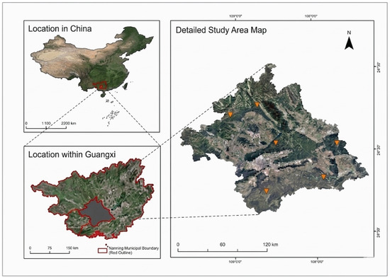
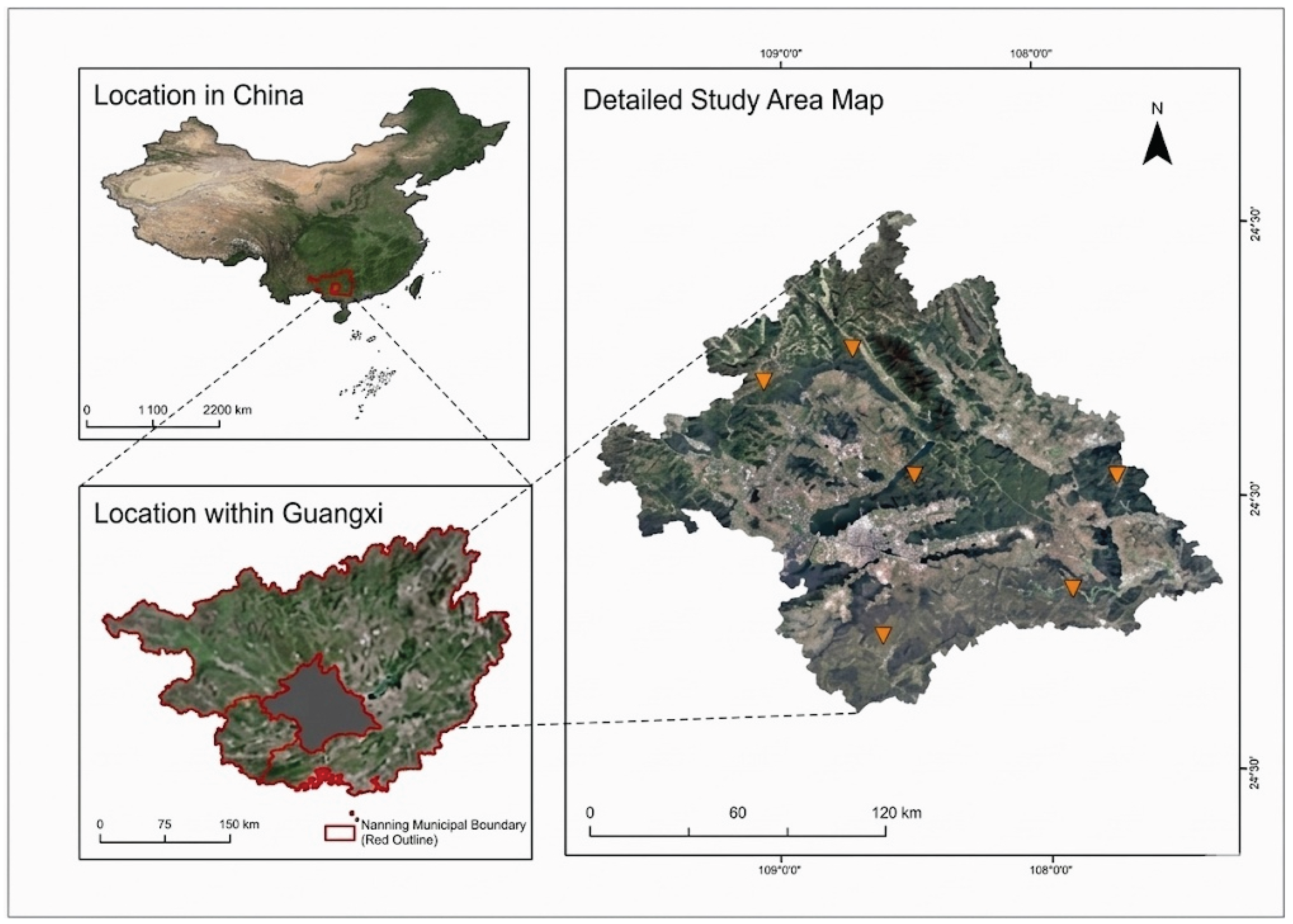
This study focuses on Nanning City, the capital of Guangxi Zhuang Autonomous Region in southern China (geographic extent: 22°13′–23°32′ N, 107°45′–108°51′ E; see Figure 1). Encompassing an area of approximately 22,112 km2, Nanning features a typical subtropical monsoon climate characterized by distinct wet and dry seasons, with a mean annual precipitation of 1300–1500 mm, over 70% of which falls between April and September [27].
Figure 1.
Study area of Nanning, Guangxi, China.
The terrain is predominantly composed of low hills and karst landscapes, interspersed with river valleys and alluvial plains. This varied topography, combined with intensive human activity, has resulted in a highly heterogeneous land cover mosaic. The landscape integrates patches of natural secondary forest, extensive agricultural land (including paddy fields and orchards), urban and peri-urban settlements, and large areas of plantation forestry.
Notably, Nanning is a core region within China’s major eucalyptus plantation belt. Driven by a strong forestry industry, fast-growing eucalyptus plantations have become a dominant and rapidly expanding land cover type. They are distributed across the landscape in diverse configurations—from large, contiguous commercial plots to small, fragmented parcels managed by individual households—often forming complex mosaics with other land uses. This combination of climatic representativeness, topographic diversity, and the pervasive presence of eucalyptus plantations in various configurations makes Nanning an ideal and representative case study for developing and testing methods for municipal-scale, high-resolution plantation monitoring.
2.2. Dataset Construction
From the selected sites, we extracted 1871 non-overlapping image patches, each with a size of 1024 × 1024 pixels (corresponding to a ground area of approximately 307 × 307 m). The eucalyptus plantations in the study area typically follow regional silvicultural standards [28], with a density of 1200–1650 trees per hectare arranged in a regular grid pattern (inter-row spacing: 3.0–4.0 m; intra-row spacing: 1.5–2.0 m). This configuration generates distinctive periodic textural patterns in 0.3 m imagery, a key visual cue leveraged for identification.
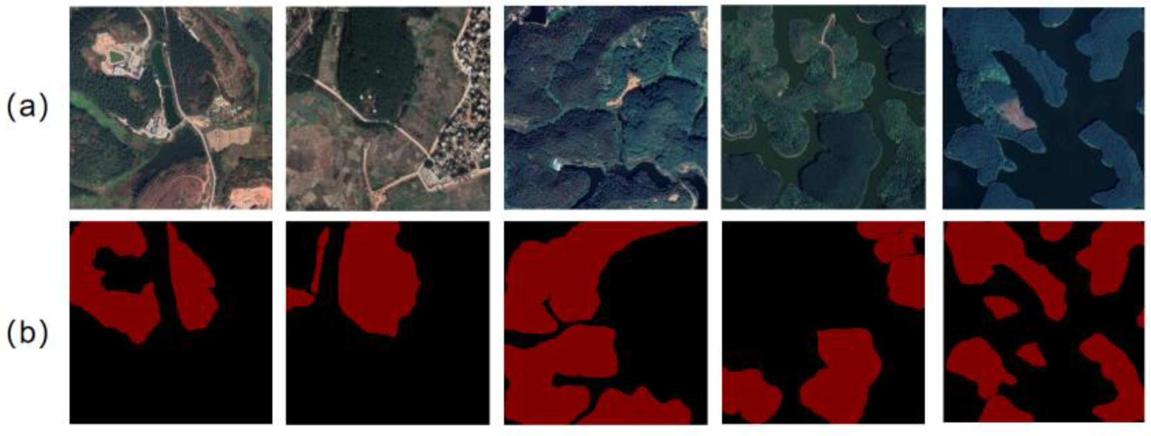
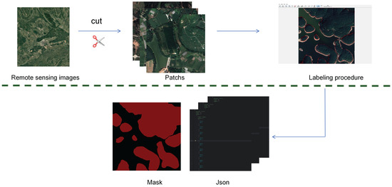
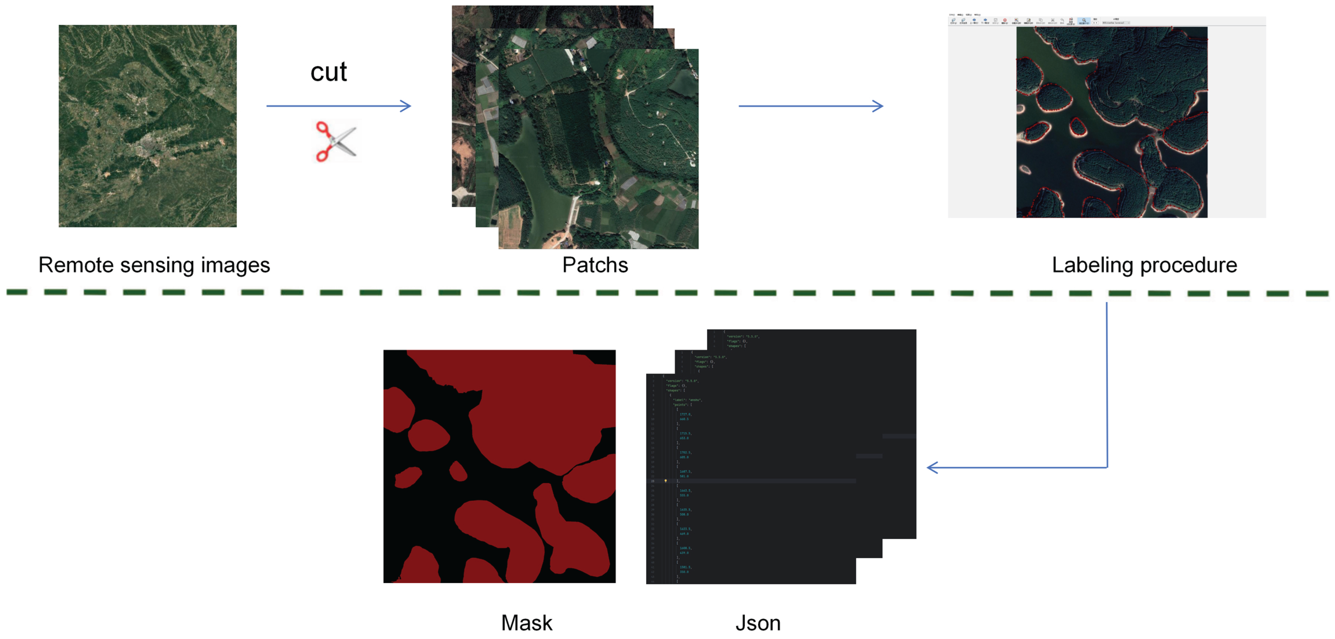
Each patch underwent manual pixel-level annotation using the LabelMe tool, following a standardized protocol. Annotators, trained and supervised by forestry remote sensing experts, labeled each pixel into one of two classes: “Eucalyptus” (including all contiguous and scattered stands) or “Background” (all non-plantation land covers, including other vegetation, soil, water, and built-up areas). The annotation process involved iterative quality control, including cross-checking by a second annotator and reconciliation by a senior expert. To mitigate edge artifacts in subsequent model training and to increase data variety, a 10% overlap was applied during patch cropping, meaning adjacent patches share a 102-pixel border. Example annotations are visualized in Figure 2.
Figure 2.
Example images in the data set. (a) Remote sensing image of eucalyptus forest (b) Label mask corresponding to remote sensing image in eucalyptus forest.
Data Partitioning
The final ESSD was partitioned into a training set and a validation set using a 9:1 ratio (Figure 3), resulting in 1683 patches for training and 188 for validation. This split prioritizes a comprehensive and diverse training signal, which is critical for the model to learn the vast array of patterns associated with multi-scale, fragmented plantations. The held-out validation set, while constituting 10% of the data, remains statistically substantial due to the large number of total pixels, providing a reliable and stable estimate of model generalization performance [29]. The ESSD, comprising both imagery and annotations, is publicly released to serve as a benchmark for future research in high-resolution plantation monitoring.
Figure 3.
The construction process of the Eucalyptus Semantic Segmentation Dataset (ESSD). First, high-resolution (0.3 m) single-period RGB remote sensing imagery is collected from Google Earth. Second, the imagery is systematically cropped into 2048 × 2048 pixel image blocks with a 10% overlap to preserve spatial context. Third, visual interpretation and fine manual annotation are conducted using the LabelMe 5.8.1 software, categorizing pixels into eucalyptus and background classes. Finally, the annotated results are exported and saved in both JSON and binary mask formats.
2.3. Model Architecture
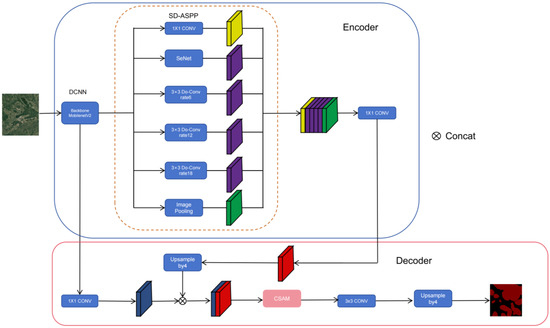
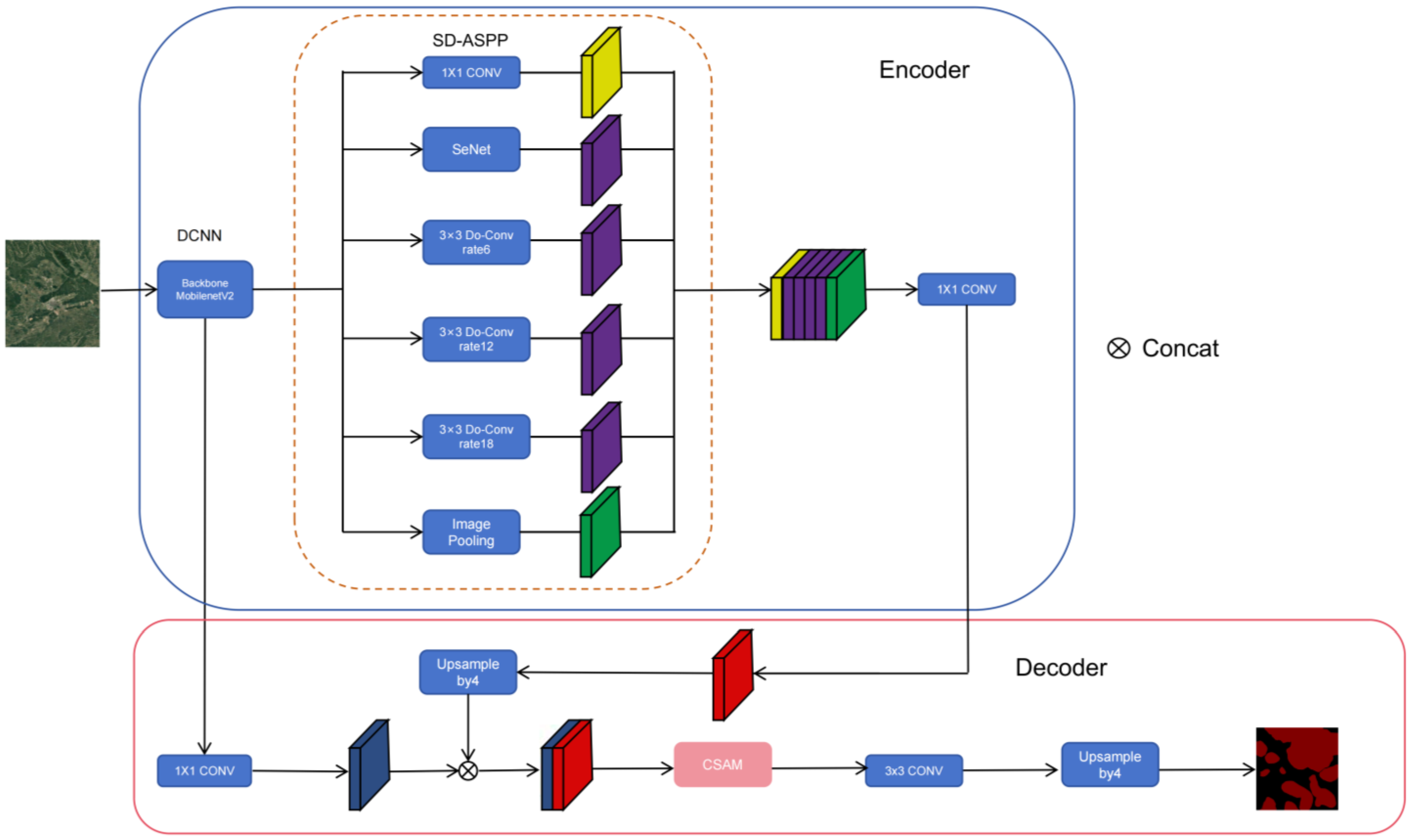
We propose SDCNet, a task-specific deep learning network tailored for the precise segmentation of eucalyptus plantations from sub-meter imagery. As illustrated in Figure 4, SDCNet is built upon the established encoder–decoder framework of DeepLabV3+ [17], renowned for its effectiveness in semantic segmentation. To optimize the trade-off between accuracy and computational efficiency for large-area application, we employ MobileNetV2 [30,31,32] as the lightweight backbone for feature extraction. The core innovation of SDCNet lies in two novel components integrated into this framework: (1) a Scale-Deformable Atrous Spatial Pyramid Pooling (SD-ASPP) module in the encoder to address multi-scale heterogeneity, and (2) a Coordinated Self-Attention Mechanism (CSAM) in the decoder to refine boundary delineation. To ensure the stability and reliability of the results, all experiments were conducted using 5-fold cross-validation, and the mean values of the evaluation metrics are reported. An ablation study comparing SDCNet’s performance with different backbone networks is summarized in Table 1.
Figure 4.
SDCnet model.
Table 1.
Performance comparison of SDCNet with different backbone networks.
2.3.1. SD-ASPP Module: Handling Multi-Scale Heterogeneity Design Principle
The extreme multi-scale heterogeneity of eucalyptus plantations—from scattered individual trees to large, contiguous stands—poses a significant challenge for standard convolutional networks with fixed receptive fields. Traditional ASPP modules capture multi-scale context using parallel atrous convolutions with predefined dilation rates. However, this static structure may not adaptively weigh the most relevant scales for highly variable targets. Our redesigned SD-ASPP module introduces two key enhancements: the integration of Deep Over-parameterized Convolution (DO-Conv) and a Squeeze-and-Excitation (SE) channel attention mechanism. DO-Conv enhances feature representation capacity with minimal computational overhead [33], while the SE mechanism allows the network to adaptively recalibrate channel-wise feature responses based on global context [34]. This combination enables the module to dynamically prioritize features from the most discriminative spatial scales for a given input patch.
Technical Implementation. The architecture of the SD-ASPP module is detailed in Figure 4. It consists of six parallel processing branches:
A 1 × 1 convolutional branch that generates a spatial attention gate.
An SE attention branch for channel-wise feature recalibration.
Three DO-Conv branches with dilation rates of 6, 12, and 18, responsible for capturing contextual information at medium, large, and extra-large scales, respectively.
A global average pooling branch to incorporate image-level context.
The input features are first gated by the spatial attention map from branch (1), focusing subsequent processing on salient regions. The outputs from all branches are then concatenated and fused through a final 1 × 1 convolution. This design allows SD-ASPP to concurrently model fine-grained details necessary for identifying isolated trees and broad contextual information required for delineating large plantation boundaries, thereby directly addressing Problem A.
2.3.2. CSAM Attention Mechanism: Refining Boundary DelineationDesign Principle
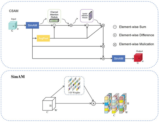
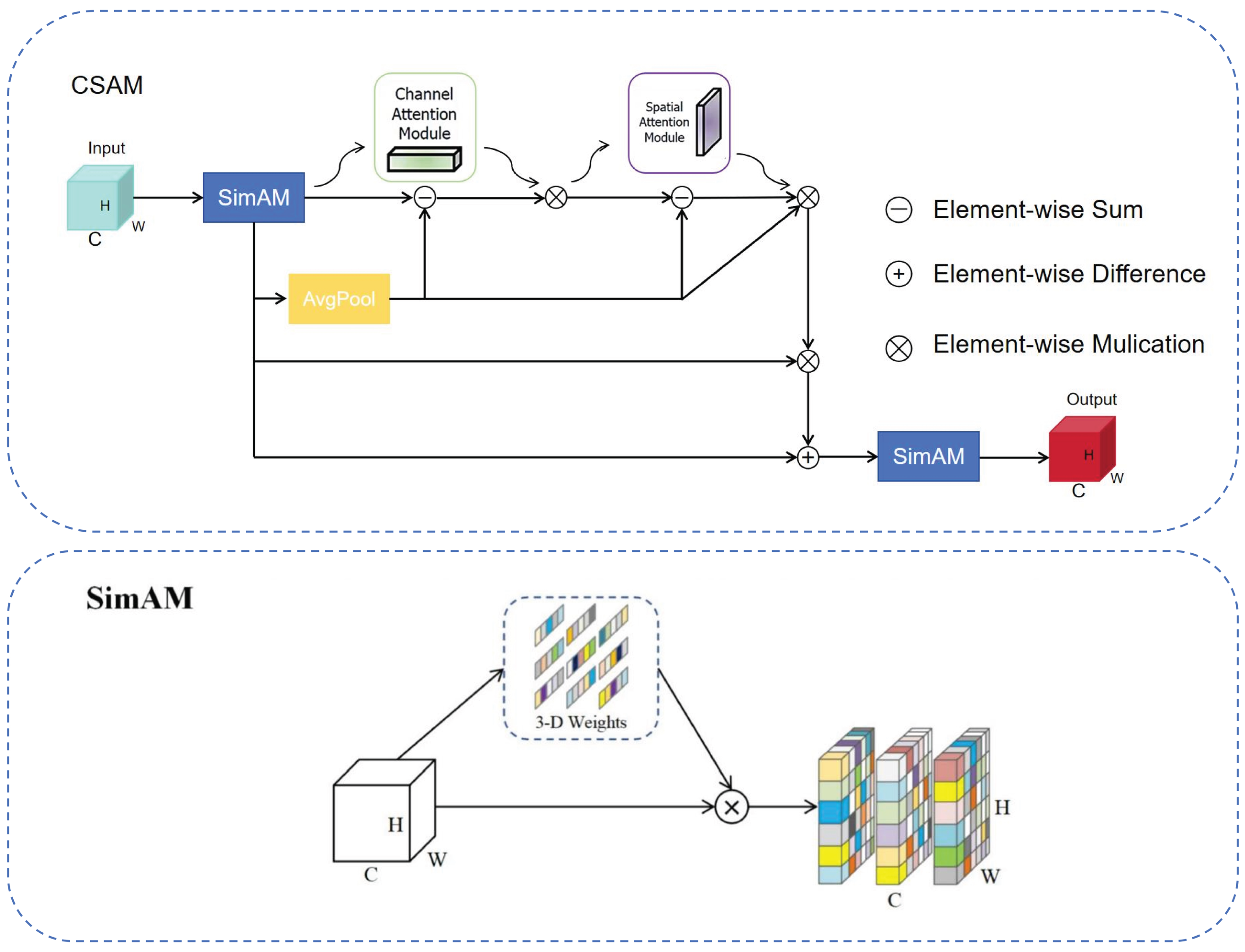
Ambiguous boundaries caused by shadows, mixed pixels, and complex canopy edges (Problem B) lead to geometric inaccuracies in segmentation maps. To address this, we designed the Coordinated Self-Attention Mechanism (CSAM) as a feature refinement block placed in the decoder path (Figure 4). CSAM synergistically combines the strengths of two powerful attention paradigms: the parameter-free 3D weight inference of SimAM [35] and the dual-pathway (channel and spatial) attention of CBAM [36]. The principle is to first use SimAM to highlight all neurons with high information content across all dimensions (channel, width, height), and then sequentially employ channel and spatial attention to further select what and where to focus on, specifically sharpening responses at high-frequency edge features.
Technical Implementation. As shown in Figure 5, the CSAM module processes input features F_in through a coordinated pipeline:
Figure 5.
CSAM model.
- SimAM-based 3D Attention: The input is first processed by a SimAM block. SimAM defines an energy function for each neuron and assigns weights inversely proportional to this energy, effectively highlighting informative features without adding parameters. The energy function for a target neuron t is defined as: where and are the mean and variance of all neurons in the same channel as t, and is a regularization term. A lower indicates higher importance, and the attention weight is computed as .
- Dual-Pathway Feature Highlighting: The attended features are then processed in two parallel paths. One path performs global average pooling to gather contextual channel statistics. The other path computes feature differences (e.g., via a Sobel filter or subtraction between dilated and eroded features) to explicitly highlight potential edge regions.
- Sequential Channel-Spatial Attention: The features are subsequently passed through a channel attention sub-module (generating a 1D channel weight vector) and a spatial attention sub-module (generating a 2D spatial weight map), following the CBAM architecture. This sequentially refines “what” features are important and “where” they are located.
- Multi-Residual Fusion: The final refined features are fused with the original F_in through a residual connection, ensuring stable gradient flow and preservation of original information. A second SimAM block is optionally applied at the output for final recalibration.
This mechanism allows CSAM to act as a sophisticated filter, precisely enhancing feature responses along semantically ambiguous canopy edges while suppressing responses from homogeneous background areas, directly tackling Problem B.
2.4. Training Protocol
The SDCNet model was implemented using the PyTorch 2.1 deep learning framework. All experiments were conducted on a workstation equipped with NVIDIA GeForce RTX 3090 GPUs.
Optimizer and Learning Rate Schedule. The model was trained using Stochastic Gradient Descent (SGD) with Nesterov momentum (coefficient = 0.9) and weight decay (5 × 10⁻⁴) to prevent overfitting. We employed a polynomial learning rate decay policy [33], where the learning rate at iteration is calculated as , with the set to 0.9. The initial learning rate was set to 0.01 after a grid search (see Supplementary Materials Figure S1). The training process ran for 80,000 iterations with a batch size of 8, which was determined to optimally utilize GPU memory while maintaining training stability.
Regularization and Model Selection. To enhance generalization, we applied dropout (rate = 0.1) after the final classification layer and utilized stochastic depth [34] within the MobileNetV2 backbone during training. Data augmentation techniques, including random horizontal/vertical flipping, rotation (±15°), and slight color jittering, were applied on-the-fly to increase the diversity of the training data. Model performance was monitored on the separate validation set (188 patches) after every epoch. The checkpoint achieving the highest mean Intersection-over-Union (IoU) on the validation set was selected as the final model for all subsequent evaluation and application.
2.5. Evaluation Metrics
Model performance was quantitatively evaluated using standard semantic segmentation metrics derived from the confusion matrix, which tabulates true positives (TP), false positives (FP), true negatives (TN), and false negatives (FN) at the pixel level.
The primary metrics reported are:
- Intersection-over-Union (IoU) for the eucalyptus class, which measures the overlap accuracy between predictions and ground truth and is sensitive to boundary errors:
- The F1-Score (Dice coefficient), which provides a harmonic mean of precision and recall, offering a balanced measure of classification performance:
We also report Precision () and Recall () for the eucalyptus class to separately quantify commission and omission errors. While overall accuracy is provided, the class-imbalanced nature of the task (plantation vs. background) makes IoU and F1-score more reliable indicators of model quality for the target class. This suite of metrics ensures a comprehensive assessment, where IoU directly reflects the geometric accuracy of boundary delineation critical for area estimation, and Precision/Recall diagnose specific error types relevant for forest inventory and management applications.
3. Results
3.1. Ablation Study: Validating the Contribution of Core Modules
To quantitatively evaluate the individual and synergistic contributions of the proposed SD-ASPP and CSAM modules, a systematic ablation study was conducted within the DeepLabV3+ framework using MobileNetV2 as the unified backbone network. The results, averaged over multiple runs, are summarized in Table 2.
Table 2.
Results of the ablation experiments evaluating the proposed modules. Performance is measured by the Intersection over Union (IoU) and F1-score for the eucalyptus class. Improvements relative to the baseline are indicated in parentheses.
The baseline model achieved an IoU of 86.59% and an F1-score of 92.10%. The incorporation of the CSAM module alone yielded substantial gains (IoU: +1.61%, F1-score: +1.27%), underscoring its critical role in refining boundary delineation by enhancing edge-aware feature responses. Similarly, adding the SD-ASPP module (even without DO-Conv) also improved performance (IoU: +1.37%), validating its effectiveness in capturing multi-scale context.
Notably, the full SD-ASPP module (with DO-Conv) achieved the highest single-module gain (IoU: +1.73%), confirming that the integration of DO-Conv within the multi-branch design successfully amplifies the model’s capacity to represent complex spatial structures. Most importantly, the integration of both modules in the complete SDCNet architecture led to the best performance (IoU: 88.83%, F1-score: 93.81%), with improvements of +2.24% in IoU and +1.71% in F1-score over the baseline. This result demonstrates a clear synergistic effect—SD-ASPP and CSAM are complementary in addressing the dual challenges outlined in the introduction: multi-scale heterogeneity (Problem A) and boundary ambiguity (Problem B), respectively.
3.2. Benchmark Comparison with State-of-the-Art Models
To rigorously assess the overall performance of SDCNet, we conducted a comprehensive benchmark against seven widely recognized and state-of-the-art semantic segmentation networks: U-Net, PSPNet, SegNet, HRNet, UPerNet, SegFormer, and DeepLabV3+ (with a ResNet-50 backbone). All models were trained and evaluated on our ESSD under identical conditions.
As detailed in Table 3, SDCNet consistently outperformed all benchmark models across the primary metrics. It achieved the highest IoU (88.83%) and F1-score (93.81%) for the target eucalyptus class, surpassing the second-best performer (SegFormer) by +1.23% in IoU and +0.71% in F1-score. Furthermore, SDCNet also attained the highest IoU for the background class (98.85%), indicating superior overall segmentation consistency and reduced false positives.
Table 3.
Performance comparison of SDCNet with seven state-of-the-art semantic segmentation models on the ESSD validation set.
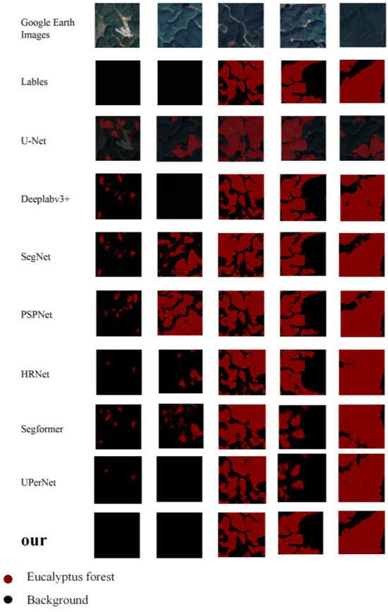
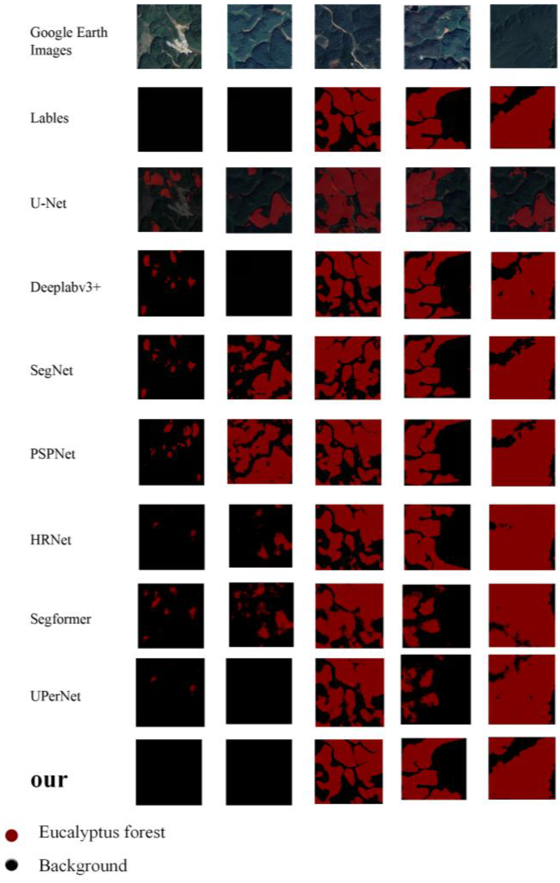
Visual comparisons (see Figure 6) corroborate these quantitative findings. SDCNet generates segmentation maps with sharper, more accurate canopy boundaries and exhibits significantly fewer omission errors in highly fragmented areas and peri-urban mosaics, where other models commonly confuse young eucalyptus stands with orchards or other vegetation. The complete numerical results, including precision, recall, and the confusion matrix, are provided in Table S1 of the Supplementary Materials.
Figure 6.
Performance comparison results of different models. The first row displays the input Google Earth optical remote sensing Eucalyptus forest images. The second row shows the ground truth labels (Labels),where the red areas represent eucalyptus forests and the black areas Background indicate the background. Rows three through nine present the prediction results of several mainstream deep learning semantic segmentation models (U-Net Deeplabv3+, SegNet, PSPNet, HRNet, Segformer, and UPerNet), respectively. The final row shows the prediction results of our proposed model (ours).
3.3. Municipal-Scale Eucalyptus Distribution Mapping and Analysis
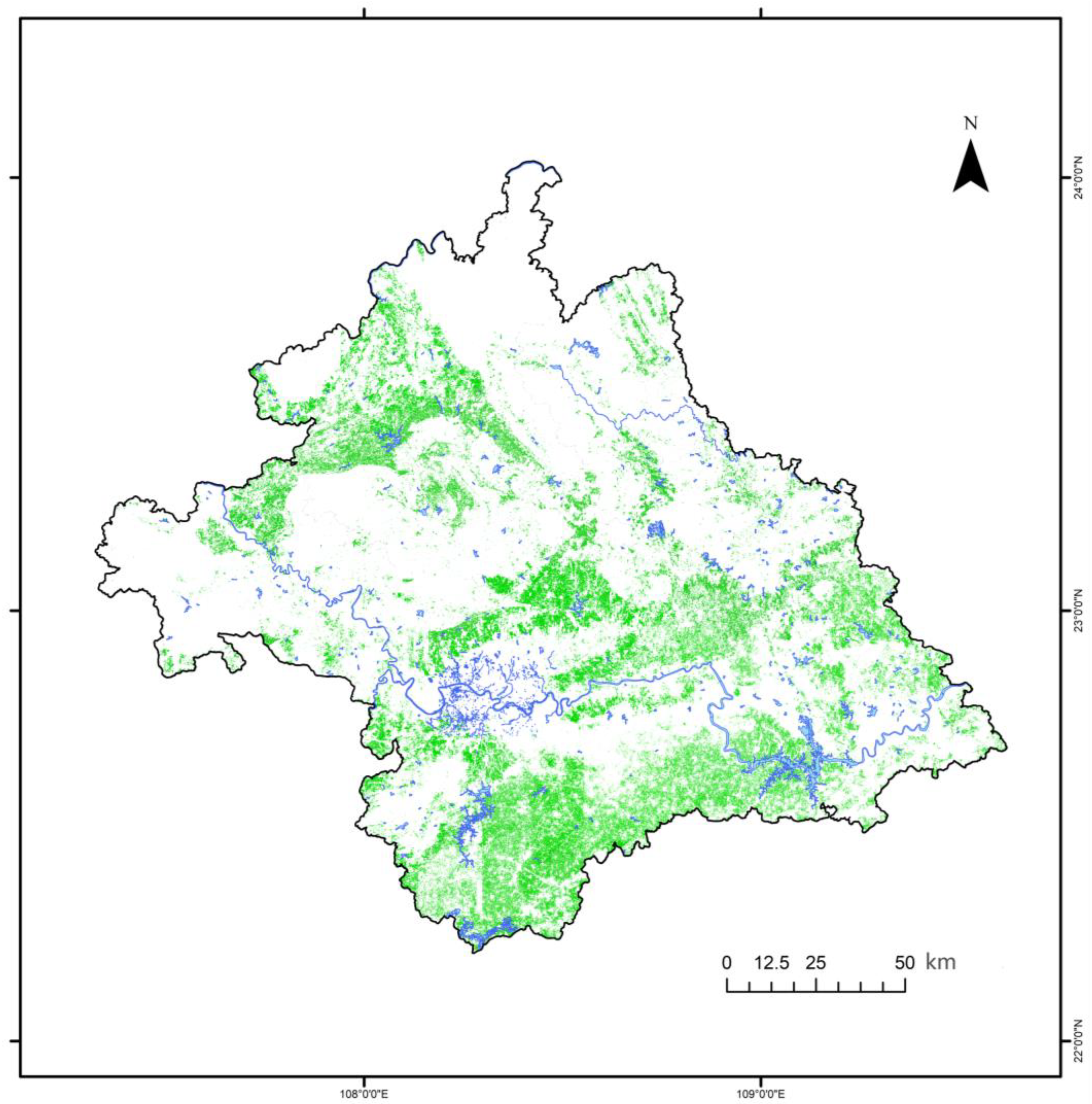
Leveraging the optimized SDCNet model, we produced the first wall-to-wall, 0.3 m resolution eucalyptus plantation distribution map for Nanning City (Figure 7). This high-fidelity product reveals several critical spatial patterns that were previously obscured in medium-resolution (e.g., Sentinel-2) maps:
Figure 7.
High-resolution eucalyptus plantation distribution map of Nanning City, Guangxi, China.
- Extensive Clustering: Large, contiguous plantations dominate the low-hill regions in the southern and western parts of the municipality.
- Fine-Scale Fragmentation: Numerous smallholder and fragmented plots are precisely delineated along roadsides, watercourses, and intermixed within cropland-orchard matrices, highlighting the fine-grained nature of local forestry.
- Peri-Urban Mosaics: A complex interlocking of eucalyptus patches with other land uses is clearly visible at the urban fringes, illustrating the land-use pressure surrounding expanding settlements.
The most salient finding from this map pertains to ecological risk assessment. Spatial overlay analysis reveals that within the watershed of the Xiyunjiang Reservoir—Nanning’s primary drinking water source—eucalyptus plantations constitute over 50% of the total forested area. This high-resolution, quantitative insight provides unprecedented, direct evidence for municipal-scale hydrological and environmental impact assessments. Furthermore, the map’s capability to identify small, irregular plots enables new applications in monitoring compliance with forestry regulations, such as detecting encroachments near protected areas or waterways—a task infeasible with coarser resolution data.
Additional experimental results and parameter sensitivity analyses are provided in the Supplementary Materials (Table S1 and Figures S1 and S2).
4. Discussion
4.1. Methodological Advances: From Generic to Tailored Solutions
The development of the ESSD and the SDCNet architecture directly addresses a critical bottleneck in high-resolution, species-specific forest monitoring. By providing the first publicly available, pixel-level annotated dataset for sub-meter eucalyptus mapping in China, ESSD fills a long-standing data gap and establishes a reproducible benchmark, complementing other specialized forestry datasets. Our experimental results underscore a key insight: generic semantic segmentation models frequently underperform when confronted with the irregular shapes, textures, and extreme multi-scale heterogeneity characteristic of eucalyptus plantations. In contrast, SDCNet—through its task-specific integration of the SD-ASPP and CSAM modules—demonstrates that architectural tailoring can yield significant accuracy gains. The SD-ASPP module, enhanced with DO-Conv, is particularly effective in adaptively capturing features across scales, enabling the model to robustly segment both contiguous plantations and fragmented smallholder plots. This represents a substantive advance over conventional convolutional approaches that rely on fixed receptive fields.
Furthermore, the statistical reliability of these methodological advances is substantiated by our rigorous experimental design. Unlike traditional single-run evaluations, all performance metrics reported in this study are derived from 5-fold cross-validation. This ensures that the observed improvements in accuracy and mIoU are not the result of fortuitous data partitioning but represent the stable, mean performance of the SDCNet across diverse subsets of the landscape. By demonstrating a consistent reduction in classification variance, our findings provide a more statistically robust foundation for high-precision area estimation in municipal forest governance, justifying the necessity of a problem-driven design philosophy over generic modeling approaches.
4.2. Comparative Analysis with Existing Mapping Approaches
When positioned within the broader context of plantation remote sensing, the advantages of our deep learning framework are multifold. Compared to traditional medium-resolution mapping using Landsat or Sentinel data [13,14]—which offers valuable regional insights but often fails to capture smallholder heterogeneity and tends to overestimate areas at forest edges—SDCNet provides unprecedented spatial detail and accuracy. Furthermore, in comparison to recent deep learning applications for eucalyptus in other regions [15,37], our model advances municipal-scale monitoring by effectively suppressing salt-and-pepper noise in the classification maps, yielding cleaner and more reliable outputs for governance applications.
These advancements align with an emerging consensus in the remote sensing community, which emphasizes moving beyond generic models toward architectures engineered for specific environmental contexts and target classes [21,38]. Consequently, the core contribution of this study is twofold: it delivers a model (SDCNet) with statistically superior quantitative performance, and it provides a validated, end-to-end framework that demonstrates the efficacy of a problem-driven design philosophy for high-resolution precision forestry.
4.3. Implications for Municipal Forest Governance and Ecological Risk
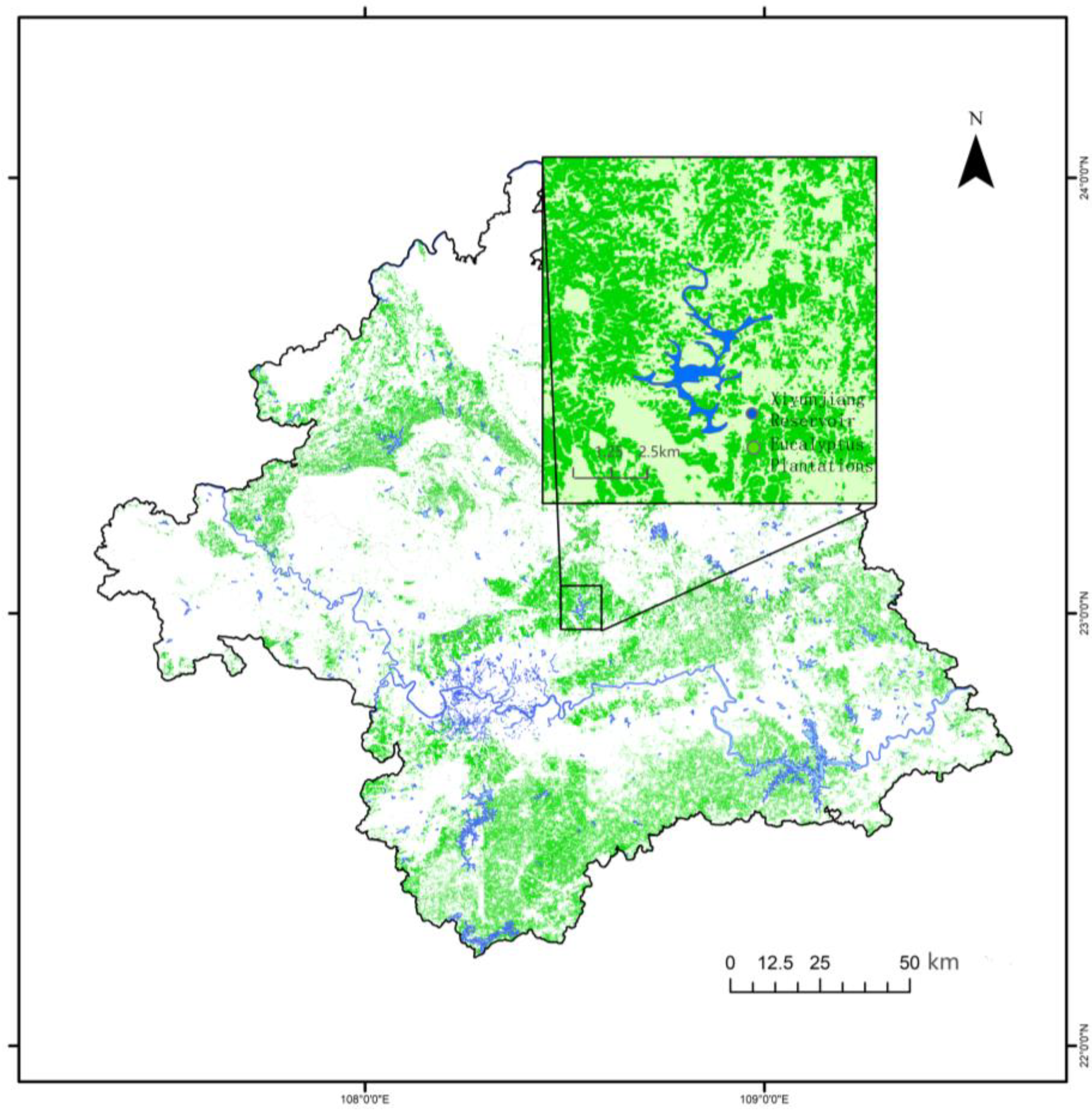
The primary applied contribution of this study is the generation of a high-resolution spatial map that transforms observational data into actionable intelligence for forest governance. The most salient finding is the pronounced spatial clustering of eucalyptus plantations, with over 50% of the forest cover within the watershed of the Xiyunjiang Reservoir—Nanning’s primary drinking water source—consisting of this single genus (Figure 8). This pattern raises immediate concerns regarding localized hydrological impacts. Extensive literature indicates that eucalyptus plantations, due to their high evapotranspiration rates, can reduce surface runoff and streamflow significantly more than native forests or other plantation types. In critical watersheds, such concentrated coverage could exacerbate water stress, especially under extreme climatic conditions, posing a potential risk to water security.
Figure 8.
Spatial Distribution of Eucalyptus Plantations in Xiyunjiang Reservoir.
The driving forces behind this clustering are likely socioeconomic (strong market incentives) and regulatory (historically insufficient spatial zoning). Beyond risk identification, the sub-meter precision of our map enables previously impossible governance applications. It allows for the precise monitoring of plantation boundaries for growth and yield estimation, the detection of encroachment into protected riparian zones—invisible in coarser 10–30 m resolution products—and provides a factual basis for enforcing land-use regulations.
Therefore, our results bridge the gap between remote sensing science and policy implementation. They highlight the urgent need for targeted watershed management strategies that could include: (1) implementing dynamic monitoring systems using frameworks like SDCNet to regulate further expansion in sensitive areas; (2) incentivizing mosaic planting patterns to mitigate hydrological risks; and (3) developing ecological compensation mechanisms to balance economic benefits with long-term water resource sustainability.
4.4. Limitations and Future Perspectives
Despite its strong performance, the SDCNet framework has limitations that chart a clear path for future research. A primary challenge is the reliable identification of eucalyptus during its early growth stages. Seedlings and saplings with sub-meter crown diameters in 0.3 m imagery exhibit high spectral and textural similarity to other green vegetation, leading to omission errors. Furthermore, the intrinsic biological diversity within the Eucalyptus genus—including variation across species, hybrids, and clones in leaf color, morphology, and vigor—introduces phenotypic variance that can be confounded with background soil and moisture effects in RGB imagery, challenging model generalization.
To overcome these limitations, future work should leverage the unique temporal and spectral signatures of eucalyptus. Integrating time-series analysis using algorithms like LandTrendr [39] or CCDC [40] would allow models to exploit the distinct, rapid growth trajectory of eucalyptus for more accurate detection and age-class estimation [41]. Fusing multi-source data is another promising direction: sub-decimeter UAV imagery can bridge the detection gap for seedlings [42], while multispectral or SAR data can provide discriminatory features beyond the visible spectrum to better handle biological variability [43]. Finally, operationalizing the framework on cloud platforms like Google Earth Engine [44] will be essential for scalable, regional monitoring and near-real-time application.
5. Conclusions
This study successfully demonstrates the feasibility and necessity of high-resolution, municipal-scale eucalyptus plantation mapping by developing an integrated framework that couples a novel, task-specific deep learning model with a first-of-its-kind benchmark dataset.
Our work makes three primary contributions. First, we constructed and publicly release the Eucalyptus Semantic Segmentation Dataset (ESSD), a high-quality, pixel-level annotated dataset derived from 0.3 m resolution imagery. By providing precise annotation masks and geographic coordinates, ESSD fills a critical data gap and establishes a reproducible benchmark for advanced algorithmic research in fine-scale plantation monitoring. Second, we proposed SDCNet, a deep learning architecture specifically engineered to overcome the two core challenges identified for eucalyptus segmentation: multi-scale spatial heterogeneity and ambiguous boundary delineation. The model’s core innovations—the SD-ASPP module for adaptive multi-scale context aggregation and the CSAM attention mechanism for boundary refinement—were validated through rigorous ablation studies, confirming their individual and synergistic efficacy. In comprehensive benchmarks, SDCNet significantly outperformed seven state-of-the-art segmentation models, achieving a top eucalyptus-class IoU of 88.83% and an F1-score of 93.81%.
Third, and most crucially for applied forestry, we leveraged SDCNet to generate the first 0.3 m resolution wall-to-wall eucalyptus distribution map for Nanning City. This map provides actionable spatial intelligence, with its most salient finding being that eucalyptus plantations constitute over 50% of the forest cover within the watershed of the Xiyunjiang Reservoir, Nanning’s primary drinking water source. This high-resolution, quantitative insight provides the first direct evidence to assess localized hydrological risks, thereby bridging remote sensing science with urgent governance needs. It underscores the indispensable value of precision mapping for informed forest inventory, ecological risk assessment, and sustainable land-use planning.
In summary, by aligning methodological innovation with concrete municipal-scale application, this research provides a robust, transferable framework. It contributes critical, evidence-based insights to the ongoing discourse on balancing the economic imperatives of plantation forestry with the paramount need for ecological stewardship and resource sustainability.
Supplementary Materials
The following supporting information can be downloaded at: https://www.mdpi.com/article/10.3390/f17040461/s1, Figure S1: Hyperparameter sensitivity analysis for learning rate and batch size; Figure S2: Visual and numerical comparison of prediction results across all benchmarked models; Table S1: Detailed evaluation metrics of SDCNet and baseline models.
Author Contributions
Conceptualization, Q.Z. and B.Z.; Methodology, B.Z. and Q.Z.; Software, B.Z.; Validation, B.Z.; Formal Analysis, B.Z.; Investigation, B.Z.; Resources, Q.Z.; Data Curation, B.Z.; Writing—Original Draft Preparation, B.Z.; Writing—Review and Editing, Q.Z. and B.Z.; Visualization, B.Z.; Supervision, Q.Z.; Project Administration, Q.Z.; Funding Acquisition, Q.Z. All authors have read and agreed to the published version of the manuscript.
Funding
This research was funded by the Shenzhen Science and Technology Program (grant number ZDSYS20210623091808026). The APC was also funded by the same project.
Data Availability Statement
Due to licensing restrictions, we do not distribute images directly. However, we publicly release (1) all annotation files (Masks) and (2) the geographic coordinates of dataset regions. Researchers can obtain images from public channels using these annotation files and original coordinates to fully reproduce the ESSD.
Acknowledgments
The authors thank the Forestry Bureau of Nanning for providing auxiliary land-use information, and colleagues from the Shenzhen Campus of Sun Yat-sen University for valuable feedback during manuscript preparation.
Conflicts of Interest
The authors declare no conflicts of interest.
References
- Payn, T.; Carnus, J.-M.; Freer-Smith, P.; Kimberley, M.; Kollert, W.; Liu, S.; Orazio, C.; Rodriguez, L.; Silva, L.N.; Wingfield, M.J. Changes in planted forests and future global implications. For. Ecol. Manag. 2015, 352, 57–67. [Google Scholar] [CrossRef] [Scilit]
- Brockerhoff, E.G.; Jactel, H.; Parrotta, J.A.; Quine, C.P.; Sayer, J. Role of eucalypt and other planted forests in biodiversity conservation and the provision of biodiversity-related ecosystem services. For. Ecol. Manag. 2013, 301, 43–50. [Google Scholar] [CrossRef] [Scilit]
- FAO. Global Forest Resources Assessment 2020: Main Report; Food and Agriculture Organization of the United Nations: Rome, Italy, 2020. [Google Scholar] [CrossRef] [Scilit]
- Barua, S.K.; Lehtonen, P.; Pahkasalo, T. Potentials, challenges and policy options for global industrial forest plantation development. Int. For. Rev. 2014, 16, 118–137. [Google Scholar] [CrossRef] [Scilit]
- Binkley, D.; Campoe, O.C.; Alvares, C.; Carneiro, R.L.; Cegatta, I.; Stape, J.L. The interactions of climate, spacing and genetics on clonal Eucalyptus plantations across Brazil and Uruguay. For. Ecol. Manag. 2017, 405, 271–283. [Google Scholar] [CrossRef] [Scilit]
- Filoso, S.; Bezerra, M.O.; Weiss, K.C.B.; Palmer, M.A. Impacts of forest restoration on water yield: A systematic review. PLoS ONE 2017, 12, e0183210. [Google Scholar] [CrossRef] [Scilit]
- Viera, M.; Rodríguez-Soalleiro, R. A globally cultivated hardwood: Eucalyptus. Forests 2019, 10, 1003. [Google Scholar] [CrossRef] [Scilit]
- Calviño-Cancela, M.; Rubido-Bará, M.; van Eeden, P.B. Biodiversity of eucalyptus plantations in comparison with native forests and pastures. For. Ecol. Manag. 2012, 267, 276–282. [Google Scholar] [CrossRef] [Scilit]
- National Forestry and Grassland Administration. Ninth National Forest Inventory Report (2014–2018); China Forestry Publishing House: Beijing, China, 2019.
- Xie, Y.; Wang, Y.; Zhang, Y.; Weng, Q. Mapping Eucalyptus plantations in Guangxi, China, using time-series Sentinel-1 and Sentinel-2 data. Remote Sens. 2020, 12, 1767. [Google Scholar] [CrossRef] [Scilit]
- Malkamäki, A.; D’Amato, D.; Hogarth, N.J.; Kanninen, M.; Pirard, R.; Toppinen, A.; Zhou, W. A systematic review of the socio-economic impacts of large-scale tree plantations, worldwide. Glob. Environ. Change 2018, 53, 90–103. [Google Scholar] [CrossRef] [Scilit]
- Trumbore, S.; Brando, P.; Hartmann, H. Forest health and global change. Science 2015, 349, 814–818. [Google Scholar] [CrossRef] [Scilit]
- Hansen, M.C.; Potapov, P.V.; Moore, R.; Hancher, M.; Turubanova, S.A.; Tyukavina, A.; Thau, D.; Stehman, S.V.; Goetz, S.J.; Loveland, T.R.; et al. High-resolution global maps of 21st-century forest cover change. Science 2013, 342, 850–853. [Google Scholar] [CrossRef] [Scilit] [PubMed]
- Wulder, M.A.; Loveland, T.R.; Roy, D.P.; Crawford, C.J.; Masek, J.G.; Woodcock, C.E.; Allen, R.G.; Anderson, M.C.; Belward, A.S.; Cohen, W.B.; et al. Current status of Landsat program, science, and applications. Remote Sens. Environ. 2019, 225, 127–147. [Google Scholar] [CrossRef] [Scilit]
- Drusch, M.; Del Bello, U.; Carlier, S.; Colin, O.; Fernandez, V.; Gascon, F.; Hoersch, B.; Isola, C.; Laberinti, P.; Martimort, P.; et al. Sentinel-2: ESA’s optical high-resolution mission for GMES operational services. Remote Sens. Environ. 2012, 120, 25–36. [Google Scholar] [CrossRef] [Scilit]
- Ronneberger, O.; Fischer, P.; Brox, T. U-Net: Convolutional networks for biomedical image segmentation. In Proceedings of the Medical Image Computing and Computer-Assisted Intervention (MICCAI), Munich, Germany, 5–9 October 2015; Springer: Cham, Switzerland, 2015; pp. 234–241. [Google Scholar] [CrossRef] [Scilit]
- Chen, L.-C.; Zhu, Y.; Papandreou, G.; Schroff, F.; Adam, H. Encoder-decoder with atrous separable convolution for semantic image segmentation. In Proceedings of the European Conference on Computer Vision (ECCV), Munich, Germany, 8–14 September 2018; Springer: Cham, Switzerland, 2018; pp. 801–818. [Google Scholar] [CrossRef] [Scilit]
- Wang, J.; Sun, K.; Cheng, T.; Jiang, B.; Deng, C.; Zhao, Y.; Liu, D.; Mu, Y.; Tan, M.; Wang, X.; et al. Deep high-resolution representation learning for visual recognition. IEEE Trans. Pattern Anal. Mach. Intell. 2020, 43, 3349–3364. [Google Scholar] [CrossRef] [Scilit]
- Xie, E.; Wang, W.; Yu, Z.; Anandkumar, A.; Alvarez, J.M.; Luo, P. SegFormer: Simple and efficient design for semantic segmentation with transformers. Adv. Neural Inf. Process. Syst. 2021, 34, 12077–12090. [Google Scholar]
- Lausch, A.; Erasmi, S.; King, D.J.; Magdon, P.; Heurich, M. Understanding Forest Health with Remote Sensing—Part I—A Review of Spectral Traits, Processes and Remote-Sensing Characteristics. Remote Sens. 2016, 8, 1029. [Google Scholar] [CrossRef] [Scilit]
- Ma, L.; Liu, Y.; Zhang, X.; Ye, Y.; Yin, G.; Johnson, B.A. Deep learning in remote sensing applications: A meta-analysis and review. ISPRS J. Photogramm. Remote Sens. 2019, 152, 166–177. [Google Scholar] [CrossRef] [Scilit]
- Fassnacht, F.E.; Latifi, H.; Stereńczak, K.; Modzelewska, A.; Lefsky, M.; Waser, L.T.; Straub, C.; Ghosh, A. Review of tree species classification from remotely sensed data. Remote Sens. Environ. 2016, 186, 64–87. [Google Scholar] [CrossRef] [Scilit]
- Natesan, P.; Armenakis, C.; Vepakomma, U. ResNet-based tree species classification using UAV images. Comput. Electron. Agric. 2019, 169, 105206. [Google Scholar] [CrossRef] [Scilit]
- Schiefer, F.; Kattenborn, T.; Bareth, G.; Kalkhoff, I.; von Holleufer, V.; Schmidtlein, S. Mapping tree species in canopy models from UAV-based photogrammetric point clouds: A multi-sensor comparison evaluating convolutional neural networks. Remote Sens. Environ. 2020, 246, 111862. [Google Scholar] [CrossRef] [Scilit]
- Kattenborn, T.; Leitloff, J.; Schiefer, F.; Hinz, S. Review on Convolutional Neural Networks (CNN) in vegetation remote sensing. ISPRS J. Photogramm. Remote Sens. 2021, 173, 24–49. [Google Scholar] [CrossRef] [Scilit]
- Adeline, K.R.M.; Chen, M.; Briand, X.; Pang, S.K.; Paparoditis, N. Shadow detection in very high spatial resolution aerial images: A comparative study. ISPRS J. Photogramm. Remote Sens. 2013, 80, 21–38. [Google Scholar] [CrossRef] [Scilit]
- Guangxi Meteorological Bureau. Guangxi Climate; China Meteorological Press: Beijing, China, 2020. [Google Scholar]
- Guangxi Forestry Bureau. Silvicultural Standards for Eucalyptus Plantations in Guangxi; Guangxi Science and Technology Press: Nanning, China, 2021. [Google Scholar]
- Goodfellow, I.; Bengio, Y.; Courville, A. Deep Learning; MIT Press: Cambridge, MA, USA, 2016. [Google Scholar]
- He, K.; Zhang, X.; Ren, S.; Sun, J. Deep residual learning for image recognition. In Proceedings of the IEEE Conference on Computer Vision and Pattern Recognition (CVPR), Las Vegas, NV, USA, 27–30 June 2016; IEEE: New York, NY, USA, 2016; pp. 770–778. [Google Scholar]
- Zhao, H.; Shi, J.; Qi, X.; Wang, X.; Jia, J. Pyramid scene parsing network. In Proceedings of the IEEE Conference on Computer Vision and Pattern Recognition (CVPR), Honolulu, HI, USA, 21–26 July 2017; IEEE: New York, NY, USA, 2017; pp. 2881–2890. [Google Scholar]
- Sandler, M.; Howard, A.; Zhu, M.; Zhmoginov, A.; Chen, L.-C. MobileNetV2: Inverted residuals and linear bottlenecks. In Proceedings of the IEEE Conference on Computer Vision and Pattern Recognition (CVPR), Salt Lake City, UT, USA, 18–22 June 2018; IEEE: New York, NY, USA, 2018; pp. 4510–4520. [Google Scholar]
- Cao, J.; Li, Y.; Sun, J. DO-Conv: Depthwise over-parameterized convolutional layer. IEEE Trans. Image Process. 2022, 31, 3726–3736. [Google Scholar] [CrossRef] [Scilit] [PubMed]
- Huang, G.; Sun, Y.; Liu, Z.; Sedra, D.; Weinberger, K.Q. Deep networks with stochastic depth. In Proceedings of the European Conference on Computer Vision (ECCV), Amsterdam, The Netherlands, 11–14 October 2016; pp. 646–661. [Google Scholar]
- Yang, L.; Zhang, R.Y.; Li, L.; Xie, X. SimAM: A simple, parameter-free attention module for convolutional neural networks. In Proceedings of the 38th International Conference on Machine Learning (ICML), Virtual, 18–24 July 2021; pp. 11863–11874. [Google Scholar]
- Woo, S.; Park, J.; Lee, J.Y.; Kweon, I.S. CBAM: Convolutional block attention module. In Proceedings of the European Conference on Computer Vision (ECCV), Munich, Germany, 8–14 September 2018; pp. 3–19. [Google Scholar]
- Lin, X.; Li, Y.; Chen, J. Eucalyptus mapping via deep learning and Google Earth Engine. In Proceedings of the IEEE International Geoscience and Remote Sensing Symposium (IGARSS), Brussels, Belgium, 11–16 July 2021; IEEE: New York, NY, USA, 2021; pp. 4522–4525. [Google Scholar]
- Zhu, X.X.; Tuia, D.; Mou, L.; Xia, G.-S.; Zhang, L.; Xu, F.; Fraundorfer, F. Deep learning in remote sensing: A comprehensive review and list of resources. IEEE Geosci. Remote Sens. Mag. 2017, 5, 8–36. [Google Scholar] [CrossRef] [Scilit]
- Kennedy, R.E.; Yang, Z.; Cohen, W.B. Detecting trends in forest disturbance and recovery using yearly Landsat time series: 1. LandTrendr—Temporal segmentation algorithms. Remote Sens. Environ. 2010, 114, 2897–2910. [Google Scholar] [CrossRef] [Scilit]
- Zhu, Z.; Woodcock, C.E. Continuous change detection and classification of land cover using all available Landsat data. Remote Sens. Environ. 2014, 144, 152–171. [Google Scholar] [CrossRef] [Scilit]
- Kennedy, R.E.; Yang, Z.; Gorelick, N.; Braaten, J.; Cavalcante, L.; Cohen, W.B.; Healey, S. Implementation of the LandTrendr algorithm on Google Earth Engine. Remote Sens. 2018, 10, 691. [Google Scholar] [CrossRef] [Scilit]
- Onishi, M.; Ise, T. Explainable Identification and Mapping of Trees Using UAV RGB Image and Deep Learning. Sci. Rep. 2021, 11, 903. [Google Scholar] [CrossRef] [Scilit]
- Joshi, N.; Mitchard, E.T.A.; Schumacher, J.; Johannsen, V.K.; Saatchi, S.; Fensholt, R. L-Band SAR Backscatter Related to Forest Cover, Height and Aboveground Biomass at Multiple Spatial Scales across Denmark. Remote Sens. Environ. 2015, 155, 179–193. [Google Scholar] [CrossRef] [Scilit]
- Gorelick, N.; Hancher, M.; Dixon, M.; Ilyushchenko, S.; Thau, D.; Moore, R. Google Earth Engine: Planetary-scale geospatial analysis for everyone. Remote Sens. Environ. 2017, 202, 18–27. [Google Scholar] [CrossRef] [Scilit]

Disclaimer/Publisher’s Note: The statements, opinions and data contained in all publications are solely those of the individual author(s) and contributor(s) and not of MDPI and/or the editor(s). MDPI and/or the editor(s) disclaim responsibility for any injury to people or property resulting from any ideas, methods, instructions or products referred to in the content. |
© 2026 by the authors. Licensee MDPI, Basel, Switzerland. This article is an open access article distributed under the terms and conditions of the Creative Commons Attribution (CC BY) license.