


Abstract
To address the problems of slow convergence, long planned paths, and excessive turning points in unmanned surface vehicle (USV) path planning under complex environments, this paper proposes a path planning method based on an Enhanced Gold Rush Optimizer (EGRO). A nonlinear adaptive parameter adjustment strategy and a stage-wise dynamic probability mechanism are designed to improve the balance between global exploration and local exploitation at different stages of iteration. In addition, a Gaussian diffusion mechanism combined with a local search operator is introduced to enhance the algorithm’s ability to escape from local optima and reduce the number of path turning points. In the remote-sensing-image-based sea-ice simulation scenario, compared with the conventional GRO, PSO, and GWO algorithms, the maximum observed improvements of EGRO in best fitness, convergence iterations, and the number of path turning points are approximately 31.65%, 51.24%, and 35.00%, respectively. The simulation results indicate that EGRO can provide a feasible swarm-intelligence-based optimization framework for USV path planning. The proposed algorithm can generate feasible paths with relatively shorter lengths and fewer turning points. These characteristics may provide a favorable geometric reference for subsequent trajectory generation and navigation control, thereby highlighting the potential value of EGRO in engineering applications of USV path planning.
1. Introduction
1.1. Background and Literature Review
USVs are robotic vessels capable of autonomous operation on the water surface [1]. Owing to their flexibility, high operational efficiency, low cost, and reduced risk, USVs have been widely applied in resource exploration, international maritime security, military operations, and ecological protection. Some maritime environments exhibit a high degree of complexity, in which USVs may be required to perform navigation support in harsh conditions, conduct ice reconnaissance in ice-covered waters, or undertake search-and-rescue and emergency-response missions in the event of accidents or hazardous situations [2]. These demanding tasks pose significant challenges to safe USV navigation, and the performance of a USV is directly related to voyage distance, mission completion time, energy consumption, and the ability to transit safely through complex environments. As a key technology for autonomous navigation and safe obstacle avoidance, path planning is therefore of great theoretical significance and engineering value for improving mission execution efficiency, environmental adaptability, and navigational safety of USVs [3]. Therefore, it is of considerable importance to investigate efficient and robust USV path planning methods with good geometric continuity of the path, so as to generate a feasible collision-free path with fewer turning points for autonomous USV navigation.
In recent years, extensive research has been conducted by scholars worldwide on path planning for mobile robots and unmanned surface vehicles, and various path planning methods have been proposed [4,5,6]. Traditional methods, such as the A* algorithm [7], RRT* algorithm [8], and artificial potential field method (APF) [9], have been widely applied to path search tasks. However, when these methods are applied to large-scale or complex environments, they may still suffer from high computational cost, susceptibility to local optima, unstable initial path quality, and strong dependence on environmental modeling. Therefore, bio-inspired and swarm intelligence optimization algorithms with flexible search mechanisms and strong global optimization capabilities have gradually attracted increasing attention in the field of path planning [10,11].
Among metaheuristic optimization algorithms, classical algorithms such as Particle Swarm Optimization (PSO) [12], Ant Colony Optimization (ACO) [13], Grey Wolf Optimizer (GWO) [14], and Genetic Algorithm (GA) [15] have been widely applied to complex optimization, path planning, and engineering optimization problems. Among them, PSO has strong capability in continuous optimization, ACO performs well in path search and route optimization problems, GWO is commonly used in complex optimization and unmanned aerial vehicle path planning tasks, and GA has been applied to USV path planning and path quality optimization. With the continuous development of metaheuristic algorithms, a number of recently proposed optimization methods, including Harris Hawks Optimization (HHO) [16], the Slime Mould Algorithm (SMA) [17], the Aquila Optimizer (AO) [18], the Dung Beetle Optimizer (DBO) [19], the Weighted Mean of Vectors Algorithm (INFO) [20], the Runge Kutta Optimizer (RUN) [21], and Golden Jackal Optimization (GJO) [22], have attracted increasing attention. These algorithms have demonstrated promising potential in global optimization, engineering design optimization, mechanical engineering optimization, image processing [23,24], and other practical optimization tasks, thereby offering new solution strategies for complex path planning problems [25,26].
Compared with path planning in environments with regular obstacles, USV path planning in complex environments is subject to stronger constraints and greater solution difficulty. In particular, in ice-covered environments, sea-ice obstacles are usually characterized by dense distribution, irregular shapes, fragmented edges, and narrow locally traversable areas. Therefore, USV path planning in such environments must not only ensure reachability from the start point to the goal point but also simultaneously consider obstacle-avoidance safety, path length, geometric continuity of the path, and search efficiency. In response to such scenarios, existing studies have improved conventional path planning algorithms or intelligent optimization algorithms. Zhang et al. [27] introduced the POLARIS risk model into a gridded environment and proposed a Risk-A* algorithm by improving the cost function and incorporating dynamic weights, thereby reducing the frequency of traversing high-risk waters while maintaining navigational efficiency and improving search efficiency. Zhang et al. [28] proposed a ship path planning method for Arctic ice-covered waters based on an improved grey wolf optimizer. By introducing Tent chaotic mapping, a Lévy flight strategy, a random walk strategy, and a greedy mechanism, the method enhances the quality of the initial population, the balance between global exploration and local exploitation, and the convergence efficiency of the conventional grey wolf optimizer, thereby improving the safety, search efficiency, and smoothness of ship path planning in ice-covered environments. Liu et al. [8] proposed an enhanced RRT* algorithm. By optimizing the sampling strategy, introducing a dynamic step size, and improving the expansion direction, the proposed method reduces the influence of randomness in the conventional RRT* algorithm and improves its convergence efficiency. Wang et al. [29] proposed a global route planning method for unmanned surface vehicles by integrating the max–min ant system with an adaptive ant colony system, thereby alleviating the search stagnation and slow convergence commonly encountered in conventional ant colony algorithms.
Although the above studies have improved path planning performance to some extent, existing methods still have certain limitations in complex environments. Traditional path planning methods usually suffer from high computational costs in large-scale scenarios or environments with high-density obstacles. Some swarm intelligence algorithms are prone to premature convergence, insufficient local refinement capability, and excessive path turning points. In addition, although recently proposed metaheuristic algorithms have shown promising potential in global optimization and engineering optimization, their adaptability and stability in complex grid-based USV path planning still require further validation. Especially in high-density and irregular obstacle environments, the algorithm needs to simultaneously balance obstacle-avoidance safety, path length, geometric continuity of the path, and search efficiency. To more clearly compare the characteristics of different methods, the advantages and disadvantages of typical path planning and optimization algorithms are summarized in Table 1.
Table 1.
Comparison of typical path planning and optimization algorithms.
In this study, the Gold Rush Optimizer (GRO) [30] is selected as the basic algorithm for USV path planning because its migration, mining, and collaboration mechanisms correspond well to global guided search, local exploitation, and population information interaction, respectively. This characteristic makes GRO compatible with the requirements of USV path planning in complex environments, including global search, local refinement, and diversity preservation. Specifically, migration guides candidate paths toward the current high-quality solution region, mining further refines path nodes in the neighborhood of promising paths, and collaboration maintains population diversity through information exchange among individuals. However, when directly applied to complex path planning tasks, the conventional GRO still has several limitations, including fixed parameter adjustment, insufficient stage adaptability in operator selection, and limited capability to escape from local optima [31]. To address these issues, this study proposes an EGRO while retaining the basic search framework of GRO, aiming to further improve the search balance and local refinement capability of the algorithm in complex obstacle environments.
1.2. Main Contributions
To address the limitations of the conventional GRO in complex USV path planning, this study proposes an EGRO for global path planning in high-density and irregular obstacle environments. Since this study does not consider the kinematic or dynamic constraints of USV, the trajectories generated in the experiments are treated as global geometric reference paths rather than directly executable motion trajectories. The main contributions of this study are summarized as follows:
- An EGRO-based global path planning framework is developed for USV in complex environments. The conventional GRO is reformulated for grid-based path planning by combining path encoding, collision constraints, boundary constraints, and path-length-oriented fitness evaluation. Within this framework, candidate paths can be evaluated under feasible conditions without collision or boundary violation. In the tested environments, the proposed algorithm can obtain navigation paths with shorter lengths and improved geometric continuity.
- Three improvement strategies are introduced to enhance the search performance of GRO. First, a nonlinear adaptive parameter adjustment strategy is designed to regulate the search intensity at different iteration stages, thereby strengthening global exploration in the early stage and improving local exploitation in the later stage. Second, a stage-wise dynamic probability selection mechanism is proposed to adaptively coordinate migration, mining, and collaboration behaviors according to the search progress. Third, a Gaussian diffusion mechanism combined with a local search operator is incorporated to enhance the ability of the algorithm to escape from local optima and further improve the geometric quality of the planned path.
- The effectiveness and robustness of the proposed EGRO are verified through both standard simulation and remote-sensing-image-based simulation experiments. A random complex obstacle grid scenario and a sea-ice remote sensing imagery scenario are constructed for performance evaluation. Comparative experiments with GRO, PSO, and GWO were conducted, together with 50 independent repeated runs and ablation analysis. The results show that, under the tested scenarios and parameter settings, EGRO demonstrates advantages in terms of feasible path length, convergence efficiency, number of path turning points, and result stability.
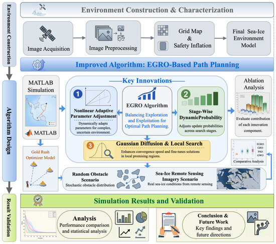
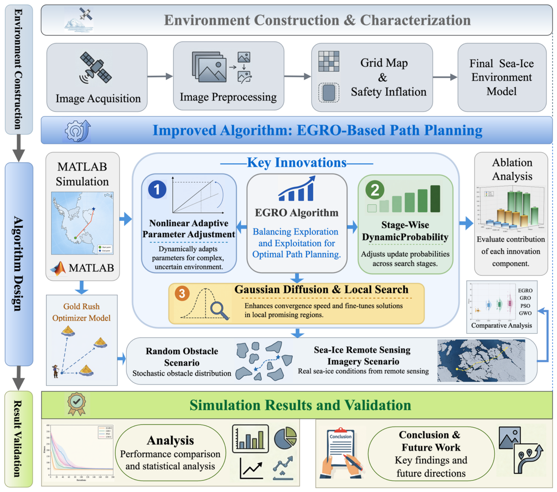
The remainder of this paper is organized as follows. Section 2 introduces the conventional GRO and presents the proposed EGRO algorithm, including the nonlinear adaptive parameter adjustment strategy, the stage-wise dynamic probability selection mechanism, and the Gaussian diffusion with local search mechanism. Section 3 describes the path encoding and fitness function and presents comparative experiments in the random obstacle scenario and the sea-ice remote sensing imagery scenario, followed by the ablation study. Section 4 discusses the experimental results and limitations of the proposed method. Section 5 concludes the paper and outlines future research directions. The specific framework of this study is shown in Figure 1.
Figure 1.
Technical framework of the proposed EGRO-based USV path planning method.
2. Algorithm Models and Definitions
GRO is essentially a continuous-space optimization algorithm, whereas the path planning task in this study is based on a discrete grid map. Therefore, the proposed method does not directly search on discrete grid nodes. Instead, it adopts a combined continuous encoding and discrete mapping strategy. Specifically, candidate paths are first updated in the continuous encoding space, and then the continuous positions are mapped to path node indices in the grid map through boundary correction and integer discretization. For infeasible paths involving collisions or boundary violations, corresponding penalty terms are introduced into the fitness function to significantly increase their fitness values, thereby reducing their competitiveness in subsequent iterations. Through this unified penalty-based evaluation mechanism, infeasible paths can be gradually suppressed during the iterative process, and feasible paths satisfying safe obstacle-avoidance requirements can eventually be obtained. At present, collision and boundary checking in this study is mainly performed on the discretized grid paths. Segment-wise collision detection between adjacent path nodes has not yet been fully considered. This issue has been discussed as a limitation in Section Limitations. The detailed components and mathematical definition of the fitness function are provided in Section 3.1. Similar path-node encoding and fitness-function-based feasibility evaluation strategies have been widely used in path planning studies based on metaheuristic algorithms [10].
To clarify how the continuous GRO update mechanism is adapted to the discrete grid-based path planning problem, the implementation procedure is summarized as follows:
Step 1: Path encoding.
Each candidate path is encoded by a set of intermediate path nodes between the start point and the goal point.
Step 2: Boundary repair.
After each position update, the path nodes are checked and repaired to ensure that they remain within the boundaries of the grid map.
Step 3: Discretization.
The repaired continuous coordinates are rounded to integer grid coordinates so that they can be mapped onto valid grid cells.
Step 4: Path reconstruction.
The start point, intermediate path nodes, and goal point are connected in sequence to reconstruct a complete candidate path.
Step 5: Feasibility checking.
Collision checking and boundary checking are mainly performed on the discretized grid nodes to determine whether the candidate path satisfies the feasibility requirements adopted in this study.
Step 6: Fitness evaluation.
Feasible paths are evaluated according to their path lengths, while infeasible paths are penalized in the fitness function.
2.1. Gold Rush Optimizer
GRO is a swarm-intelligence-based metaheuristic optimization algorithm. It searches the solution space through three core behaviors, namely migration, mining, and collaboration, and uses a greedy selection mechanism to achieve iterative improvement and facilitate global optimization [30].
2.1.1. Population Initialization and Search-Space Formulation
Let the dimensionality of the solution space be d, and let the population size be N. The position matrix of the gold prospectors, denoted by MGP, is defined as follows:
where xij denotes the position component of the i-th gold prospector in the j-th dimension.
During the iteration process, the fitness function f(Xi) is used to evaluate the fitness value of each individual. The population fitness vector MF is obtained by evaluating the positions of all gold prospectors as follows:
2.1.2. Migration Operator
Let denote the best gold mine position (i.e., the current global optimal solution). Then, for the i-th gold prospector, the following is defined as follows:
where denotes the current position of the i-th gold prospector, denotes its updated position, t is the current iteration number, and is the migration direction vector. The coefficient vectors and are used to control the migration step size and direction, respectively, and are calculated as follows:
where and are random vectors in [0, 1], and l1 is the convergence factor. When , l1 decreases nonlinearly, thereby enabling finer control over the convergence rate.
where Tmax denotes the maximum number of iterations.
2.1.3. Mining Operator
This mechanism uses a randomly selected individual as a “candidate ore point” and applies a differential perturbation to it:
The coefficient vector is controlled by the independent convergence parameter l2, and is defined as follows:
Similar to l1, l2 also decreases with iteration, but its design places greater emphasis on improving the search precision of the algorithm in the local solution space during the later stage.
2.1.4. Collaboration Operator
The GRO introduces a three-agent collaboration-based search mechanism to simulate information interaction and task coordination among team members during the gold mining process.
where g1 and g2 denote two additional randomly selected gold prospectors, and denotes the collaboration vector.
2.1.5. Greedy Selection
At each iteration, if the fitness value of the new position is better than that of the current position, the update is accepted; otherwise, the prospector remains at the current position. For a minimization problem, this behavior can be modeled as follows:
2.2. Enhanced Gold Rush Optimizer
Although the conventional GRO possesses a certain level of global optimization capability, its parameter adjustment scheme and operator selection mechanism are relatively fixed, making it difficult to adaptively regulate the search behavior according to different stages of the search process. As a result, when dealing with complex, multi-constrained, and multimodal optimization problems, it is prone to insufficient search coverage in the early stage, premature convergence in the later stage, and limited local optimization capability [32]. Moreover, when GRO is applied to USV path planning, these deficiencies in search balance and local-optimum escape are further amplified.
Based on the above analysis, this study improves the GRO from three aspects, namely the parameter adjustment mechanism, the behavior selection mechanism, and the mechanisms for local-optimum escape and local path-structure refinement. The corresponding improvement modules and their effects are summarized in Table 2.
Table 2.
Analysis of EGRO improvement modules and their effects.
2.2.1. Nonlinear Adaptive Parameter Adjustment Strategy
The convergence factors l1 Equation (5) and l2 Equation (9) in the migration and mining operators have an important influence on the search behavior of the algorithm. Specifically, l1 mainly affects the search step size of the migration operator and is closely related to the global exploration capability of the algorithm, whereas l2 mainly affects the perturbation intensity of the mining operator and is associated with the local exploitation capability of the algorithm. In the conventional GRO algorithm, the relevant parameters are adjusted using linear or simple power-function decay strategies. Although these strategies are easy to implement, they are difficult to accurately meet the dynamic requirements of the search process, namely broad global exploration in the early stage and high-precision local exploitation in the later stage.
To address this issue, this study applies nonlinear adaptive adjustment to l1 and l2, respectively, so that the algorithm maintains strong search capability in the early iterations, while gradually narrowing the search range and enhancing fine-grained local exploitation in the later iterations. The expressions are given as follows:
where t denotes the current iteration number, Tmax denotes the maximum number of iterations, and and are used to control the value levels of the convergence factors in the early and later stages of iteration, respectively. In this study, and are adopted. This setting is determined by referring to the variation range of the convergence factors in the original GRO algorithm and by considering the search requirements of the path planning problem.
The quadratic nonlinear decay form of allows the migration operator to maintain a relatively large search step size in the early stage, thereby enhancing global exploration capability, and then gradually narrows the search range in the later stage to improve convergence accuracy. The exponential decay form of enables the mining perturbation intensity to decrease progressively with the iterations, while retaining small perturbations in the later stage to strengthen local exploitation around high-quality solutions. In this way, EGRO can better adapt to the transition requirement from global search to local refinement in path planning.
2.2.2. Stage-Wise Dynamic Probability Selection Mechanism
In the conventional GRO algorithm, the migration, mining, or collaboration operator is randomly selected with a fixed probability at each iteration, with the selection probability of each operator set to 1/3. Although this fixed-probability mechanism is simple in form, it is difficult to dynamically adjust the search behavior according to changes in the search stage, which may lead to insufficient global exploration in the early stage or inadequate local exploitation in the later stage.
To address this issue, this study designs a stage-wise dynamic probability selection mechanism according to the iteration progress. The search process is divided into three stages: exploration-dominant, balance-transition, and exploitation-dominant stages, and the selection probabilities of the three operators are set differently at each stage. The operator selection probabilities at different stages are defined as follows:
where and denote the selection probabilities of the collaboration, mining, and migration operators, respectively, with . Here, denotes the current iteration number, and denotes the maximum number of iterations.
The above probability settings follow the principle of enhancing exploration in the early stage, maintaining balance in the middle stage, and strengthening exploitation in the later stage. In the exploration stage, the probability of the collaboration operator is appropriately increased to 0.4, which helps expand the search coverage by utilizing differential information among individuals. In the balance-transition stage, equal probabilities are restored to maintain coordination between global exploration and local exploitation. In the exploitation stage, the probability of the mining operator is increased to 0.4, which helps strengthen local refinement within the neighborhood of current high-quality solutions.
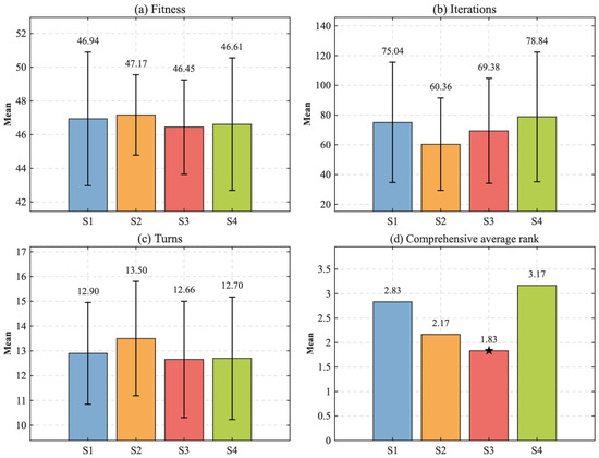
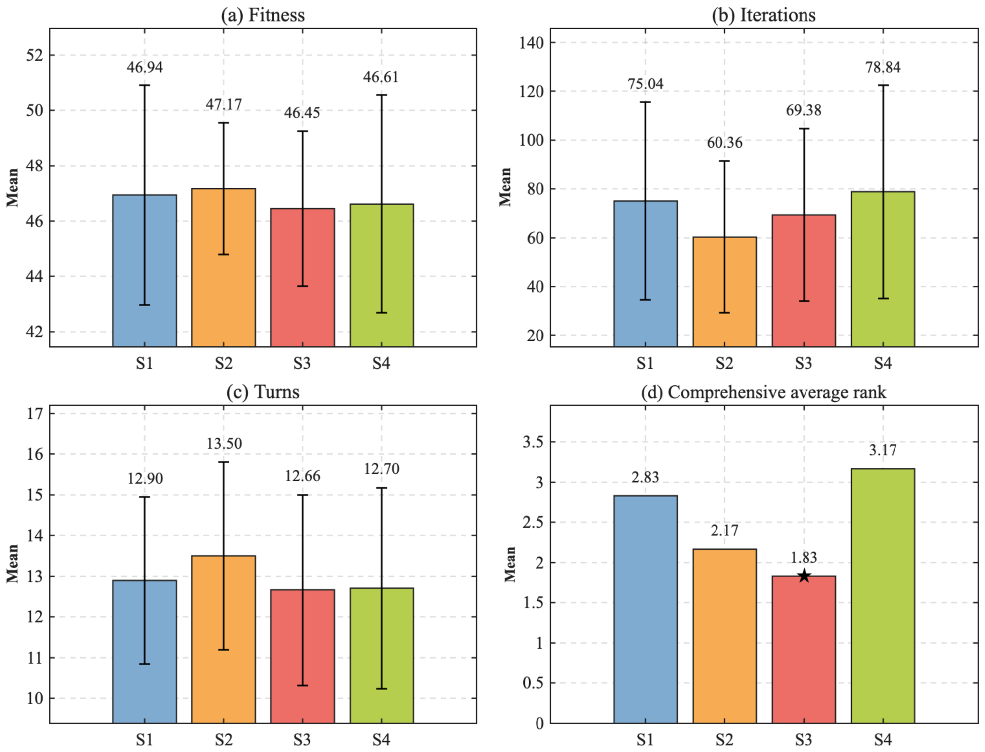
To verify the rationality of the empirical parameters used in the stage-wise dynamic probability selection mechanism, a parameter sensitivity analysis was conducted in the same random obstacle scenario. Four parameter settings were compared, namely S1 with equal probabilities, S2 with weak adjustment, S3 with the setting adopted in this study, and S4 with strong adjustment. The results are shown in Table 3 and Figure 2. Among the four parameter settings, S3 achieves the best overall performance.
Table 3.
Sensitivity analysis results of stage-wise dynamic probability parameters.
Figure 2.
Sensitivity analysis of stage-wise dynamic probability parameters.
In Figure 2d, the five-pointed star represents the optimal scheme. The final overall mean rank is obtained by averaging six rank values, including the mean and standard deviation rankings of best fitness, convergence iterations, and the number of path turning points. A smaller value indicates better overall performance. The values 0.2, 0.3, and 0.4 are not strictly theoretically optimal, but are stable empirical parameters obtained by making small stage-wise adjustments based on the conventional equal-probability mechanism of 1/3, while considering the functional characteristics of the operators, the search requirements of path planning, and the results of multiple preliminary trials. This setting can highlight the dominant search task at each stage while ensuring that all three operators retain a certain triggering probability, thereby avoiding overly monotonous search behavior.
2.2.3. Gaussian Diffusion and Local Search Mechanism
In the later stage of iteration, the conventional GRO algorithm is prone to premature convergence due to the reduction in search step size and the decline in population diversity, which weakens its ability to escape from local optima. In path planning problems, even if the algorithm can obtain a feasible path, the resulting path may still suffer from local detours and dense turning points, thereby affecting the geometric continuity of the path and practical maneuverability. To address the above limitations, this study introduces a Gaussian diffusion mechanism (Gaussian Diffusion, GD) [33] and a local search operator [34] into the EGRO algorithm, so as to enhance the neighborhood research capability of the algorithm and further optimize the geometric characteristics of the planned path.
The basic idea of the GD mechanism is to generate randomly perturbed candidate solutions around the current global best solution, allowing the algorithm to continue searching for potentially better solutions within the neighborhood of high-quality solutions. Since the Gaussian distribution is characterized by neighborhood sampling centered around its mean, this study takes the current global best position as the perturbation center and constructs a diffusion perturbation model by incorporating the distance information between each individual and the current best solution. First, the Gaussian perturbation scale corresponding to the i-th individual at the t-th iteration is defined as follows:
The new candidate solution generated by Gaussian diffusion can be expressed as follows:
where
where indicates that the diffusion adjustment coefficient undergoes small Gaussian fluctuations around 0.5. Here, 0.5 is used to maintain a moderate distance-based perturbation intensity, avoiding insufficient local search caused by overly small perturbations and preventing candidate solutions from deviating too far from the current high-quality solution region due to overly large perturbations. The coefficient 0.1 is used to control the amplitude of random fluctuations, allowing the diffusion process to retain a certain degree of randomness while maintaining the stability of local exploitation. denotes the new candidate solution generated by Gaussian diffusion; denotes the current global best position; denotes the current position of the -th individual; denotes the Gaussian perturbation scale; is a random vector following a standard normal distribution; Rs is a scalar random variable following a standard normal distribution. is the diffusion adjustment coefficient used to control the influence of the distance-based perturbation term.
To further improve the local search quality of the current best solution, a local search operator is introduced after the Gaussian diffusion mechanism. This operator performs dimension-wise random perturbation on the encoding of the current global best path and retains better solutions according to the greedy criterion. Let the current best path encoding be , where denotes the dimension of the path encoding. By randomly replacing the -th dimensional variable, a candidate solution is obtained as follows:
Then, the candidate solution is selectively updated according to the path fitness function:
where denotes the candidate path encoding after local perturbation, denotes the new value obtained by randomly replacing the -th dimensional variable, denotes the upper bound of the path-node variable, and denotes the path fitness function. Through dimension-wise random perturbation and fitness-based greedy updating, this operator further searches for potentially better paths in the neighborhood of the current high-quality solution, thereby improving the local optimization capability of the algorithm.
2.2.4. Overall Framework of EGRO
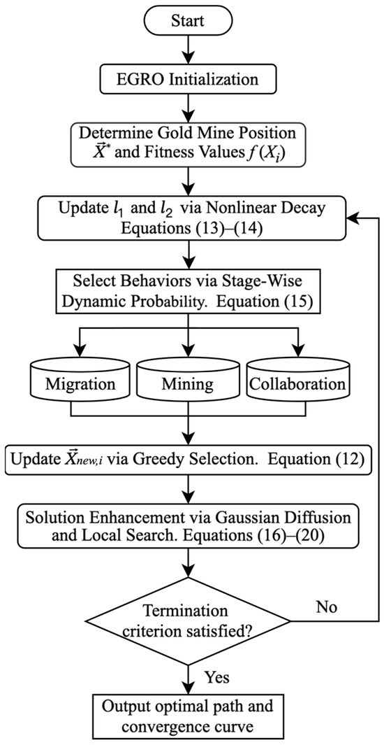
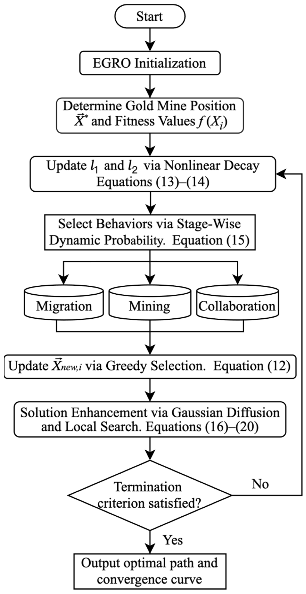
Based on the above improvements, the specific steps and flowchart of the EGRO algorithm are presented as follows:
- (1)
- Initialize the population size N, the maximum number of iterations M, and the upper and lower bounds of the search space, and set the initial global best solution together with its fitness value.
- (2)
- Randomly generate the initial gold prospector position matrix MGP within the search space.
- (3)
- The population fitness values are compared to identify the gold prospector with the current global best fitness, whose position is denoted by and whose fitness is denoted by f(Xi).
- (4)
- Adaptively update the migration step-size parameter l1 and the mining perturbation parameter l2 using the nonlinear decay strategy, as given in Equations (13) and (14), to regulate the search intensity of the algorithm at different stages.
- (5)
- According to the current iteration progress, apply the stage-wise dynamic probability mechanism to randomly select the migration, mining, or collaboration strategy for updating the position of each gold prospector, as given in Equation (15), thereby generating the new position.
- (6)
- Calculate the fitness value of the new position and determine whether to update the individual position using the greedy selection strategy given in Equation (12).
- (7)
- Update the current global best solution of the population, perturb according to the Gaussian diffusion mechanism given in Equations (16)–(18), and perform local intensification search according to Equations (19)–(20) to further refine the candidate path structure.
- (8)
- If the termination condition is satisfied, output the optimal path together with its fitness value; otherwise, return to Step 4 and continue with Steps 4–7.
As illustrated in Figure 3, EGRO establishes an optimization framework that integrates nonlinear parameter adjustment, stage-wise operator selection, and Gaussian diffusion with local refinement. Compared with the conventional GRO, this framework is better suited to the solution requirements of path planning in complex environments, namely expanding the search range in the early stage, balancing search behaviors in the middle stage, and strengthening local optimization in the later stage, thereby providing an algorithmic foundation for the subsequent experimental validation.
Figure 3.
Flowchart of the EGRO algorithm.
3. Experimental Results and Analysis
To thoroughly validate the effectiveness of the proposed EGRO algorithm in USV path planning tasks, this study constructs two types of test scenarios: a standard grid-based obstacle environment and a remote-sensing-image-based sea-ice simulation scenario constructed from remote sensing imagery. These scenarios are used to evaluate the algorithm in both typical simulation and remote-sensing-image-based simulation scenarios. PSO is a classical swarm intelligence optimization algorithm that has been widely applied in path planning research, while GWO is a representative metaheuristic algorithm with competitive performance in convergence efficiency and optimization accuracy. Therefore, PSO, GWO, and the conventional GRO algorithm are selected as benchmark methods for comparative experiments with EGRO under the same experimental settings.
3.1. Path Encoding and Fitness Function Design
To facilitate the optimization of global USV paths using the EGRO algorithm, this study adopts a path-node sequence to encode candidate paths [35]. Let denote a candidate path composed of the start point, intermediate path nodes, and the goal point, where represents the -th path node. The path length is calculated by accumulating the Euclidean distances between adjacent nodes:
To ensure the feasibility of the planned path, collision and boundary-violation penalties are introduced into the fitness function. If a candidate path is collision-free and does not exceed the boundary, the feasible path length is used as the fitness value. If the path involves collision or boundary violation, penalty terms are added to the estimated path length. The fitness function is defined as follows:
where denotes the number of nodes passing through obstacle grid cells, denotes the number of boundary violations. The subsequent experimental results in this study are all obtained based on feasible paths without collision or boundary violation. The collision penalty coefficient and the boundary-violation penalty coefficient are set to 15 and 20, respectively. They are mainly used as auxiliary constraint-handling parameters to increase the fitness values of paths involving collisions or boundary violations, thereby effectively suppressing infeasible paths during fitness minimization and elitist selection. As long as the penalty terms are sufficient to prevent infeasible paths from having a competitive advantage over feasible paths, their specific values do not play a dominant role in the comparative performance of the algorithms. The path planning problem can be transformed into a fitness-function minimization problem:
where denotes the set of candidate paths that satisfy the boundary and obstacle-avoidance constraints.
Under this condition, the fitness value is equal to the actual length of the feasible path; therefore, minimizing the fitness function is equivalent to minimizing the length of the feasible path. Accordingly, the “best fitness” reported in the experiments can be interpreted as the optimal path length under the given constraints.
3.2. Validation in a Random Obstacle Scenario
3.2.1. Experimental Results and Comparison
A two-dimensional grid map was constructed to simulate the navigation scenario of a USV in a complex environment. A binarization method was adopted to map obstacle regions to black obstacle cells and traversable regions to white free cells. To ensure the consistency of the comparative experiments, the population size of all algorithms was uniformly set to , and the maximum number of iterations was set to . Because the scale of this scenario is relatively moderate, overly small parameter settings may lead to insufficient search coverage and inadequate convergence, whereas excessively large settings would introduce unnecessary computational overhead. Therefore, the above parameters are selected by balancing population diversity and solution efficiency, so as to ensure a fair comparison among different algorithms under a unified search budget. The planned paths generated by different algorithms and their corresponding best-fitness convergence curves are shown in Figure 4a and Figure 4b, respectively, while the results of a single run are listed in Table 4.
Figure 4.
Comparative results of different algorithms in the random complex obstacle scenario.
Table 4.
Performance comparison of different algorithms in the 30 × 30 complex environment.
The EGRO algorithm shows relatively good path quality and convergence performance in the random complex scenario. As shown in Figure 4a, the blue square indicates the start point, and the red square indicates the goal point. The path planned by EGRO can avoid densely distributed obstacle regions and shows relatively good overall geometric continuity. In contrast, the paths generated by GRO and PSO exhibit obvious detours and circuitous movements near complex obstacles, resulting in increased path redundancy. Although GWO can generate a feasible path, it produces many polyline segments even in open-water areas, with excessively large turning angles, leading to an unsatisfactory planned path. Meanwhile, as shown by the convergence curve in Figure 4b, the EGRO algorithm exhibits a very rapid decrease in fitness during the early iterations, indicating that it can guide the search toward the neighborhood of high-quality solutions at an earlier stage. In addition, EGRO reaches a stable state within fewer iterations and converges to a better fitness value, indicating that it can identify high-quality solutions more efficiently in the tested complex search space.
From the results of the single experiment, EGRO shows better performance in terms of feasible path length, convergence speed, and path geometry quality. Since the final paths generated by all algorithms satisfy the collision-free and boundary-feasible constraints, the best fitness values in the table can be regarded as the lengths of the feasible paths. Therefore, the lowest best fitness value of EGRO indicates that it can find a shorter feasible path; its smallest number of convergence iterations shows that the algorithm can reach the neighborhood of high-quality solutions more quickly; its fewest turning points indicate better geometric continuity of the generated path.
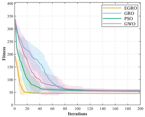
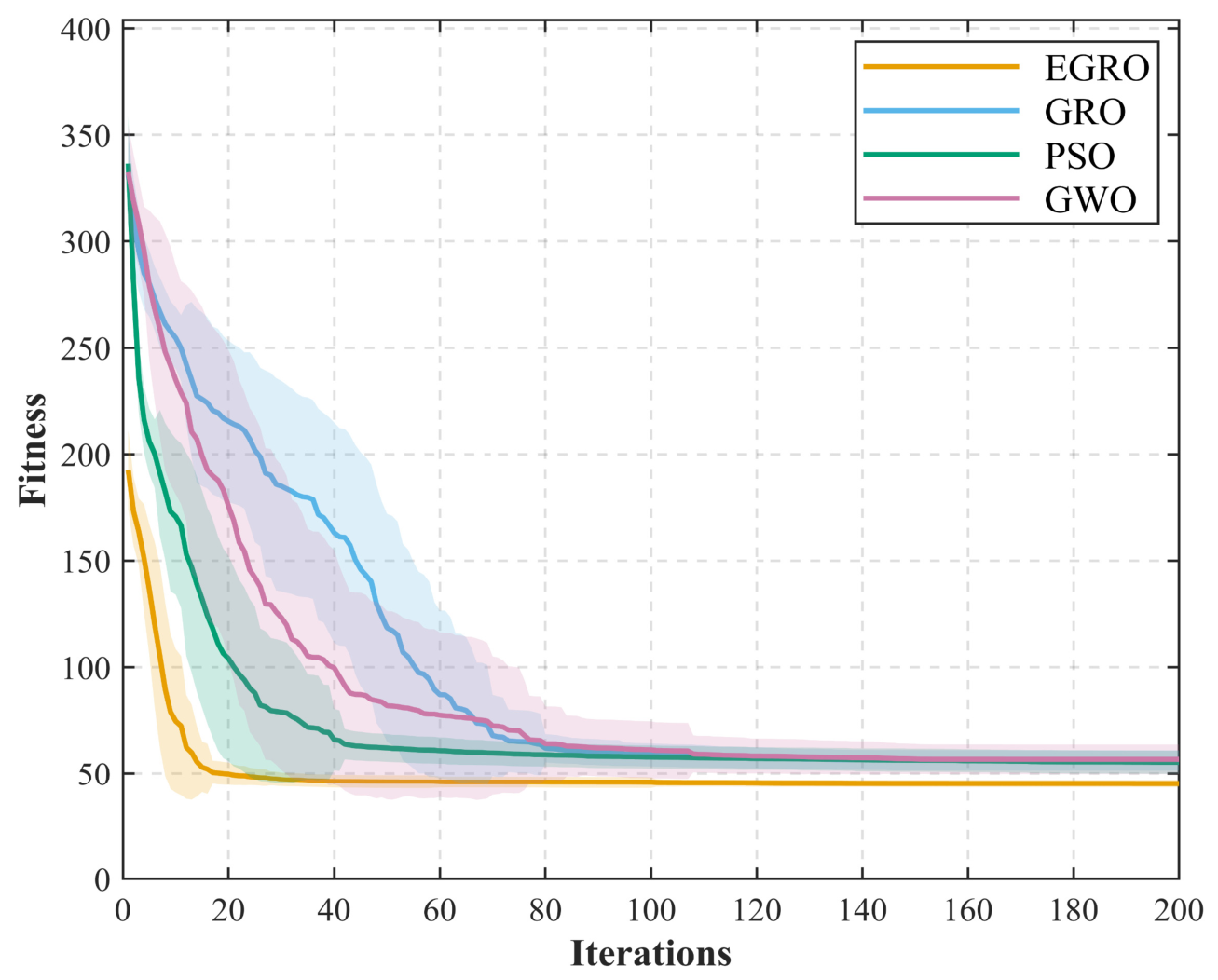
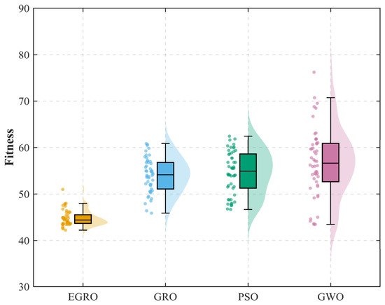
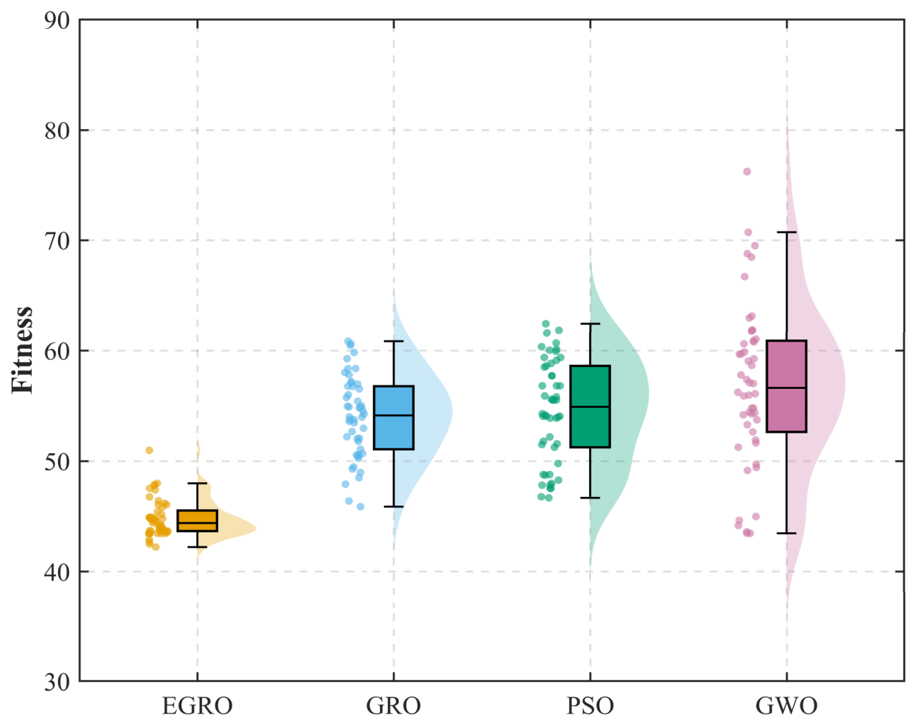
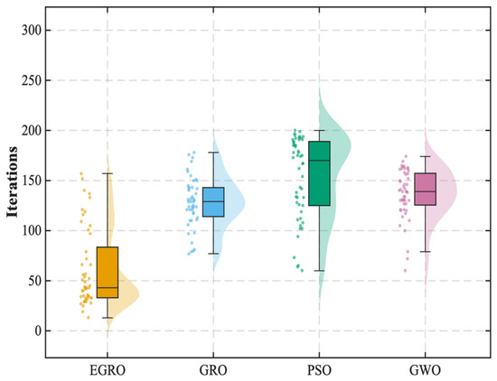
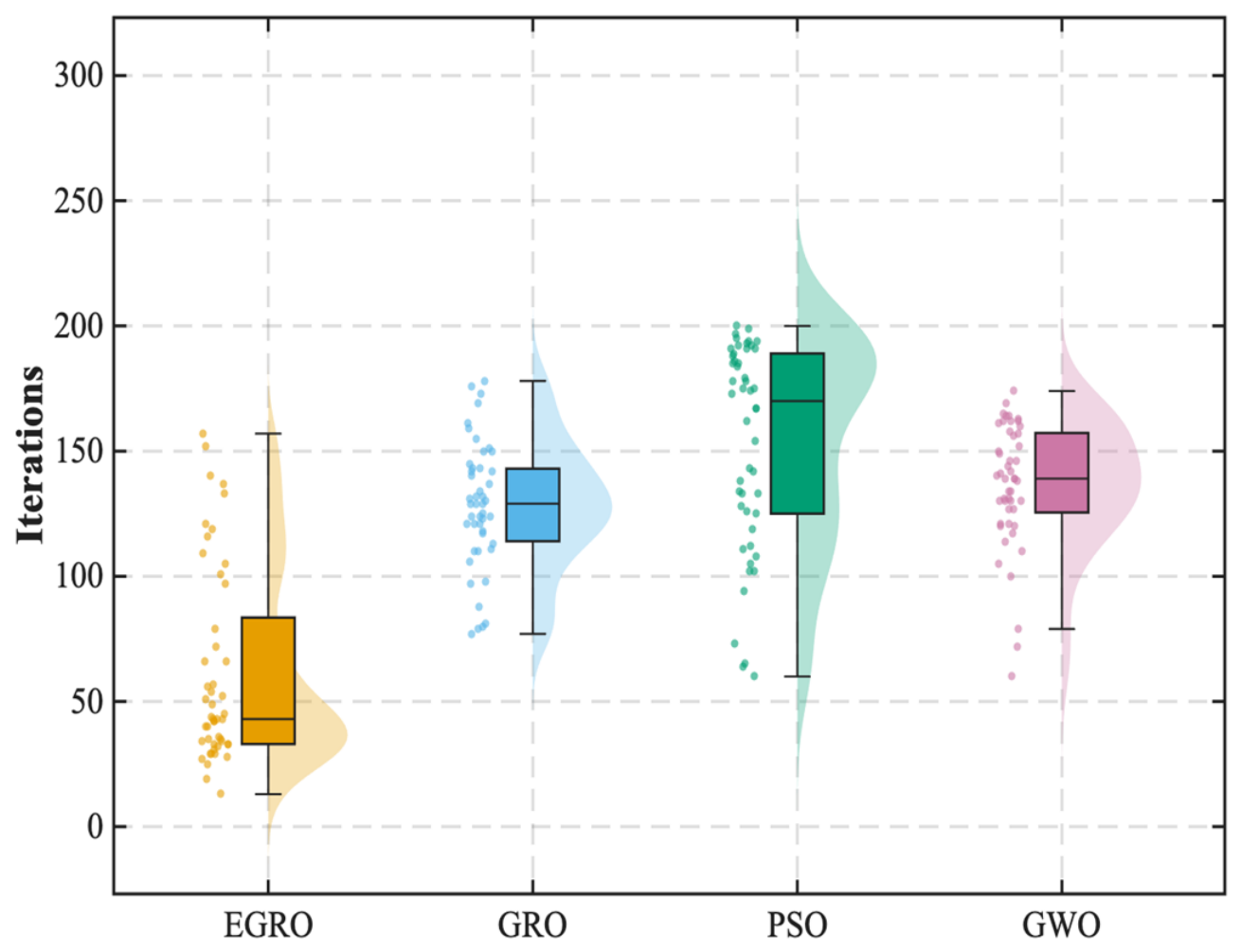
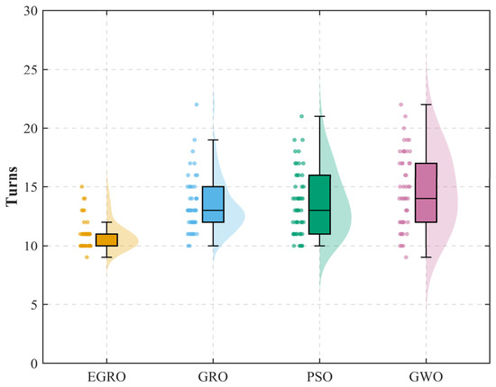
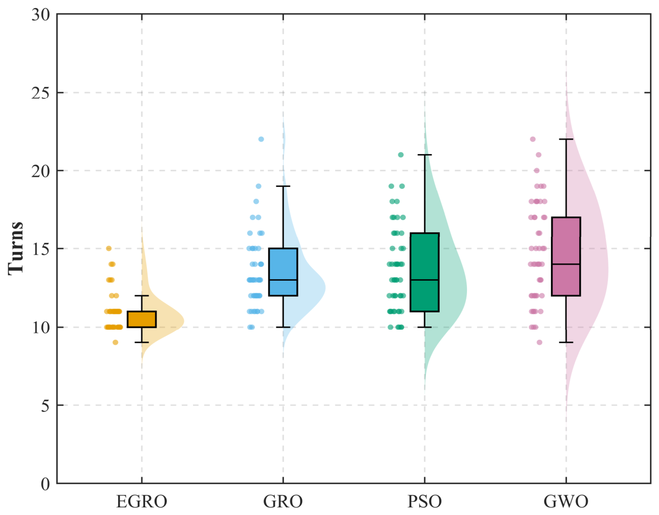
Considering the stochastic nature of metaheuristic algorithms, 50 independent repeated experiments were conducted for EGRO, GRO, PSO, and GWO under the same environmental settings and consistent parameter configurations, so as to further reduce the influence of randomness on the experimental conclusions. The statistical results are presented in Table 5. Figure 5 shows the average convergence curves of the algorithms together with their standard deviation bands, while Figure 6, Figure 7 and Figure 8 further illustrate the distribution characteristics of the key evaluation metrics using raincloud plots.
Table 5.
Statistical performance comparison based on 50 independent runs.
Figure 5.
Mean convergence curves with standard deviation bands.
Figure 6.
Raincloud plot of fitness value distribution.
Figure 7.
Raincloud plot of iteration distribution.
Figure 8.
Raincloud plot of turning-point distribution.
The results of multiple independent runs further demonstrate that the EGRO algorithm exhibits better stability and robustness. As shown in Table 5 and Figure 5, the EGRO algorithm exhibits a faster decline in fitness during the early stage of iteration and tends to reach a stable state within fewer iterations, indicating that it can guide the search process toward the neighborhood of high-quality feasible solutions at an earlier stage, thereby contributing to improving both early-stage search efficiency and later-stage convergence quality. At the same time, the standard deviation band corresponding to the convergence curve of the EGRO algorithm is noticeably narrower, indicating smaller convergence fluctuations across the 50 independent repeated experiments and a higher degree of consistency in the evolutionary trajectories under different random seeds, which reflects stronger stability and robustness. In contrast, the GRO, PSO, and GWO algorithms exhibit relatively wider standard deviation bands and generally higher initial fitness values, suggesting that they are more sensitive to random initialization. As a result, the early-stage search directions of their populations differ more substantially, leading to relatively weaker overall convergence stability.
Further insights can be obtained from Table 5 and the raincloud plots of the three key evaluation metrics shown in Figure 6, Figure 7 and Figure 8, which indicate that the EGRO algorithm demonstrates superior performance in terms of best fitness value, number of iterations, and number of path turning points.
First, as shown in the best fitness value distribution in Figure 6, the results of EGRO are the most concentrated, with the lowest median and the smallest degree of dispersion, indicating that it is more likely to obtain high-quality solutions in repeated experiments and is less affected by randomness, thereby exhibiting better stability in solution quality and stronger global optimization capability.
Second, as shown in the iteration distribution in Figure 7, although EGRO exhibits a certain degree of fluctuation, its median is significantly lower than those of GRO, PSO, and GWO, indicating that, in most cases, it is able to complete high-quality path search with fewer iterations and thus achieve higher overall convergence efficiency. Meanwhile, its relatively wide distribution range does not imply degraded convergence performance; rather, it more likely reflects that, in a few cases, the algorithm moderately prolongs the local search process in exchange for better solution quality, thereby achieving a more reasonable dynamic balance between search efficiency and optimization accuracy, which also indicates that EGRO possesses strong adaptive regulation capability.
Finally, as shown in Figure 8, the paths generated by EGRO contain significantly fewer turning points than those of the other three benchmark algorithms, and their distribution is more concentrated, indicating a clear advantage in path geometry optimization. In complex environments, fewer turning points indicate better geometric continuity, which helps reduce frequent turning maneuvers and abrupt heading changes during USV navigation, thereby providing a better reference path for subsequent trajectory tracking control.
To more intuitively compare the comprehensive performance of different algorithms, an algorithm ranking analysis was further conducted based on the results of the above 50 independent experiments.
As shown in Table 6, EGRO achieves the lowest mean rank and the best overall ranking, further indicating that it has good comprehensive performance and result stability in the random obstacle scenario.
Table 6.
Performance and stability ranking of different algorithms based on 50 independent runs.
3.2.2. Statistical Significance Analysis
To further verify the statistical significance of the performance differences between EGRO and the baseline algorithms, the Wilcoxon rank-sum test was performed based on the results of 50 independent runs. Since EGRO, GRO, PSO, and GWO are all stochastic optimization algorithms, their repeated-run results may not strictly follow a normal distribution. Therefore, this nonparametric test was adopted for statistical analysis. Taking EGRO as the reference algorithm, pairwise comparisons were conducted with GRO, PSO, and GWO in terms of best fitness, convergence iterations, and the number of path turning points. The significance level was set to the commonly used standard of . When , the performance difference between EGRO and each baseline algorithm was considered statistically significant.
As shown in Table 7, all -values are far below the significance level of 0.05, indicating that the performance differences between EGRO and the three baseline algorithms are statistically significant across all evaluation metrics. Specifically, EGRO shows significant differences from GRO, PSO, and GWO in terms of best fitness, convergence iterations, and the number of path turning points. This indicates that the advantages of EGRO are not only reflected in the mean results of repeated experiments, but are also supported by statistical significance. Therefore, the statistical test results further verify that EGRO exhibits good optimization performance and result stability in complex obstacle scenarios, demonstrating the effectiveness and reliability of the proposed improvement strategies.
Table 7.
Wilcoxon rank-sum test results between EGRO and baseline algorithms.
3.2.3. Ablation Study
To further verify the specific contributions of the proposed improvement strategies to algorithm performance enhancement, an ablation study is conducted on the improved Gold Rush Optimizer in the obstacle grid environment described in Section 3.2.1. According to the order in which the improvement modules are introduced, the proposed strategies are divided into four modules:
- (1)
- GRO: Original Gold Rush Optimizer
- (2)
- EGRO-A: GRO with the nonlinear adaptive parameter adjustment strategy
- (3)
- EGRO-AB: EGRO-A with the stage-wise dynamic probability selection mechanism
- (4)
- EGRO: EGRO-AB with Gaussian diffusion and local search mechanisms
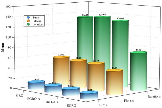
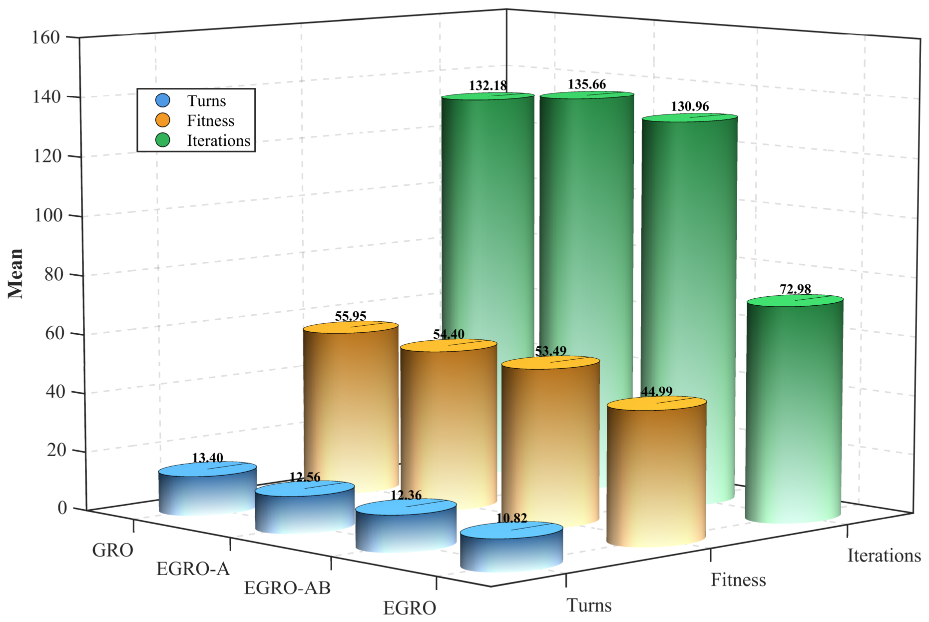
To ensure experimental fairness, all algorithm variants are independently run 50 times under the same map environment, identical population size, the same maximum number of iterations, and a consistent fitness function. The best fitness value, number of iterations, and number of path turning points are adopted as performance evaluation metrics to ensure the comparability and objectivity of the experimental results. The experimental results are shown in Table 8 and Figure 9.
Table 8.
Ablation study results and stage-wise performance gains.
Figure 9.
Mean performance comparison of ablation variants.
The results of the ablation study show that all three improvement strategies proposed in this study contribute positively to the performance enhancement of the algorithm, and that the complete EGRO achieves the best overall performance. As shown in Table 8 and Figure 9, with the progressive introduction of the improvement modules, the algorithm exhibits a clear stage-wise optimization trend in terms of optimization accuracy, convergence efficiency, and path quality. This indicates that the improvement modules are not merely superimposed, but rather form good complementarity at the levels of search intensity regulation, operator scheduling, and local refinement, thereby jointly promoting the overall performance enhancement of the algorithm.
- (1)
- The nonlinear adaptive parameter adjustment strategy mainly improves the search adequacy and path quality of the algorithm. Compared with the original GRO, EGRO-A achieves improvements of 2.77% and 6.27% in best fitness value and number of path turning points, respectively. This indicates that the strategy can, to a certain extent, alleviate the limitation of the original GRO, whose parameter variation pattern is relatively simple, enabling the algorithm to maintain stronger global search capability in the early stage and more reasonable local exploitation capability in the later stage, thereby improving path quality and reducing unnecessary turns. It should be noted that the average number of iterations at this stage increases slightly, suggesting that this improvement focuses more on enhancing search adequacy and solution quality, while its direct contribution to convergence speed is relatively limited. In some cases, it may even require the algorithm to invest more iterations in order to obtain better results.
- (2)
- The stage-wise dynamic probability mechanism further improves the search rhythm of the algorithm and the balance between global exploration and local exploitation. After incorporating this mechanism into EGRO-A, EGRO-AB achieves a 1.67% improvement in best fitness value, a 3.46% improvement in the average number of iterations, and a 1.59% improvement in the number of path turning points compared with the previous stage. The stage-wise dynamic probability mechanism plays a positive role in regulating the search behavior of the algorithm. By dynamically allocating the triggering probabilities of the three behaviors, namely migration, mining, and collaboration, according to the iteration progress, the mechanism enables the algorithm to place greater emphasis on expanding the coverage of the solution space in the early search stage and gradually strengthen local exploitation in the later stage, thereby improving path quality while maintaining convergence efficiency.
- (3)
- The Gaussian diffusion and local search mechanisms are the key improvements driving the significant performance enhancement of EGRO. After these mechanisms are further incorporated into EGRO-AB, the complete EGRO achieves a 15.89% improvement in best fitness value over the previous stage, with a cumulative improvement of 19.59% relative to the original GRO. The average number of iterations is improved by 44.27%, with a cumulative improvement of 44.79%, while the number of turning points is improved by 12.46%, with a cumulative improvement of 19.25%. These results indicate that the Gaussian diffusion mechanism can effectively enhance the research capability of the algorithm in the neighborhood of the current high-quality solutions, thereby increasing its ability to escape from local optima. The local search mechanism, meanwhile, can further refine local path structures and reduce unnecessary turning points while preserving collision-free feasibility, and therefore contributes particularly significantly to the improvement in path quality and the reduction in turning points. Although the standard deviation of EGRO in the number of iterations becomes larger, this is more likely to reflect that the algorithm performs more sufficient local refinement in some runs in order to obtain better path quality, rather than implying any degradation in overall performance.
3.2.4. Computational Cost Analysis
Since EGRO introduces several additional improvement mechanisms, especially Gaussian diffusion and local search mechanisms, its execution time may increase compared with the conventional GRO and other baseline algorithms. To further evaluate the computational cost of the compared algorithms, 50 independent runs were conducted for each algorithm under the experimental environment described in Section 3.2.1, and the execution time was recorded. The mean and standard deviation of the execution time were then calculated and compared.
As shown in Table 9, EGRO requires a longer execution time than the conventional GRO and the other baseline algorithms. This is mainly because EGRO introduces additional Gaussian diffusion and local search mechanisms, which increase the computational operations during the iterative process. However, under the tested scenario in this study, the average execution time of EGRO is 1.7140 s, and the execution times of all algorithms remain within a short time range. Therefore, although EGRO introduces additional computational overhead, its absolute time cost is still acceptable under the experimental conditions of this study. These results indicate that EGRO improves path planning performance with only a moderate increase in computational cost, without causing a substantial reduction in overall computational efficiency. This issue is also further discussed as a limitation in Section Limitations.
Table 9.
Execution time comparison of different algorithms.
3.3. Validation in a Remote-Sensing-Image-Based Sea-Ice Simulation Scenario
3.3.1. Construction of the Sea-Ice Grid Environment
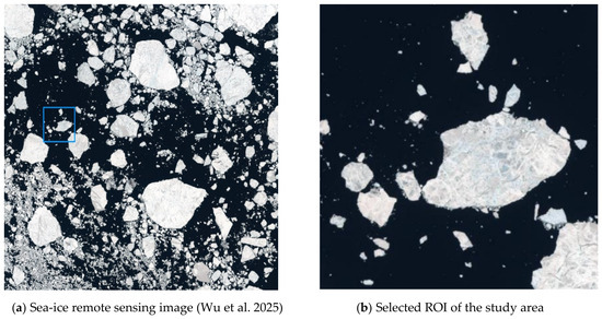
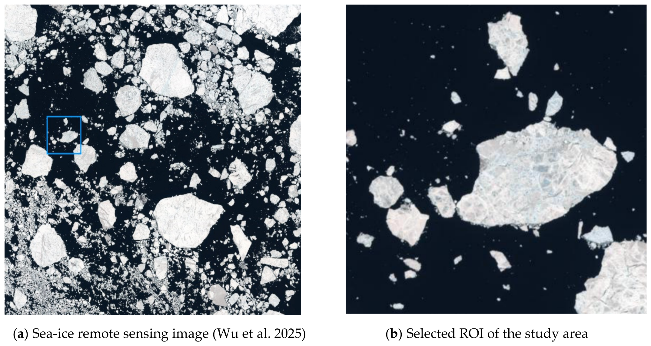
Given that ice-covered environments exhibit typical characteristics of complex scenarios in terms of obstacle spatial distribution, boundary shape complexity, and navigational constraints, sea-ice remote sensing imagery is adopted in this study to construct the experimental environment for simulation testing, so as to further validate the superiority and applicability of the EGRO algorithm in complex scenarios. To transform the sea-ice remote sensing scenario into a two-dimensional discrete environment solvable by the path planning algorithm, this study constructs the scenario through conventional image processing procedures, including grayscale conversion, binarization, and gridding. The sea-ice remote sensing dataset used in this study was derived mainly from sea-ice remote sensing images in the NWPU Dataset released by Northwestern Polytechnical University, together with sea-ice remote sensing images downloaded from the Google Earth platform (http://earthengine.google.com/). High-resolution sea-ice remote sensing imagery was used as the original data source for the experiments (Figure 10a). Considering the complexity of ice-covered environments, the original imagery was processed by extracting the Region Of Interest (ROI) [36]. A representative mixed ice area containing large-scale ice masses, fragmented floating ice, and open water was selected as the study area (Figure 10b), so as to ensure that the test scenario was representative and could adequately reflect the navigational constraints in ice-covered waters.
Figure 10.
Sea-ice remote sensing image and study area selection [37].
To convert the optical image into an environment matrix recognizable by the computer, the ROI image was processed through grayscale conversion and binarization. First, the RGB image was transformed into a grayscale image using the weighted average method to eliminate the interference caused by redundant hue information. Subsequently, the threshold was adaptively determined using Otsu’s maximum between-class variance method [38], and the image was divided into obstacle regions and free water areas. Since the sea-ice regions in the selected remote sensing image usually exhibit higher brightness, whereas the water regions show lower brightness, bright regions with grayscale values greater than the threshold are classified as sea-ice obstacles, while dark regions with grayscale values less than or equal to the threshold are classified as navigable free space [39]. Let denote the grayscale value of pixel . The binarized grid map can be defined as follows:
where represents a sea-ice obstacle grid, and represents a navigable water grid.
In addition, Otsu threshold segmentation may be affected by illumination variations, shadows, sea-ice texture, and mixed water–ice regions. Therefore, before generating the grid map, the segmentation result is visually checked to avoid obvious classification errors. However, this method is essentially a threshold-based segmentation approach and still has certain limitations under complex illumination conditions or highly heterogeneous water–ice mixed regions. In future work, more robust sea-ice segmentation methods will be considered.
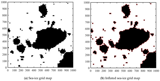
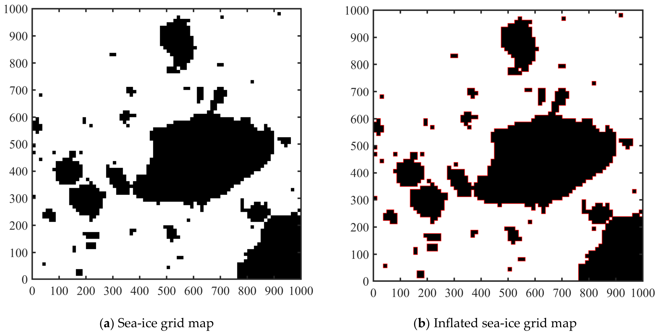
Based on the binarized image, this study adopts the grid method to discretize the continuous physical sea area into a spatial model. The physical dimensions of the study area are . To balance the environmental resolution and the computational efficiency of the path planning algorithm, the region is divided into an square grid matrix (Figure 11a), where . Accordingly, the physical resolution of each grid cell can be calculated as .
Figure 11.
Sea-ice grid map construction.
Considering the actual hull dimensions of the USV, the hysteresis characteristics of its maneuvering system, and the uncertainty in ice-edge geometry, directly treating the sea-ice pixel boundaries as impassable boundaries is often overly optimistic. To incorporate an engineering safety margin, this study performs obstacle inflation on the sea-ice obstacles based on the occupancy grid map [40]. In this study, a 2–4 m USV is taken as the reference object. To effectively compensate for trajectory tracking errors of the low-level controller and lateral drift caused by high-speed maneuvering, and to reduce the collision risk induced by control delay or positioning errors, a 3 m safety margin is set to prevent the planned path from being too close to sea-ice obstacles. A 3 m safety buffer is defined at the physical coordinate scale of the original binary image; that is, the boundaries of sea-ice obstacles are first expanded outward by 3 m at the physical scale of the original image, and then the inflated obstacle regions are mapped to the final grid map according to the spatial scale conversion relationship, so as to provide the necessary safety redundancy (Figure 11b).
In this grid model, the set of black grid cells, denoted by , is defined as the impassable region, while the set of white grid cells, denoted by , is defined as the free search space. The core task of the path planning algorithm is therefore to find an optimal collision-free path within that connects the start point and the goal point .
3.3.2. Experimental Validation in the Sea-Ice Remote Sensing Imagery
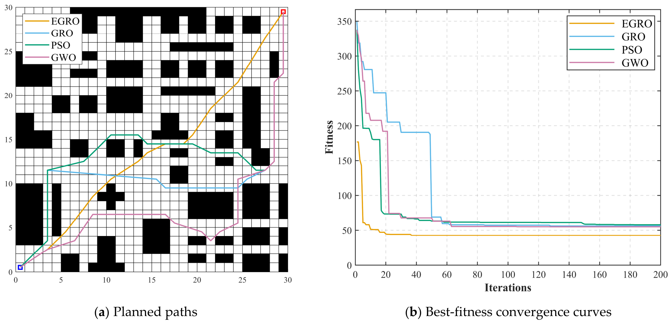
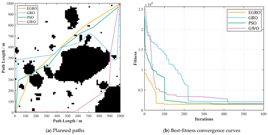
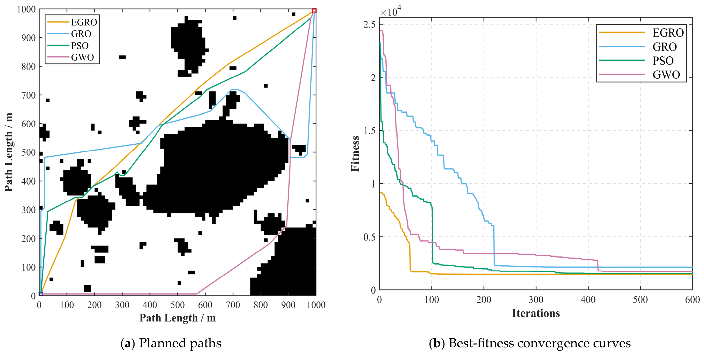
In the sea-ice scenario, to improve the population coverage of complex feasible regions and provide a more sufficient search budget for local optimization in the later stage, this study correspondingly increases the population size and the maximum number of iterations, setting the population size to and the maximum number of iterations to . GRO, PSO, and GWO are selected as benchmark algorithms to ensure that the experimental analysis is sufficiently representative and comparable. The quantitative results are presented in Table 10, and the planned paths and convergence curves of the compared algorithms are shown in Figure 12a and Figure 12b, respectively.
Table 10.
Performance comparison of different algorithms in the sea-ice scenario.
Figure 12.
Experimental results in the remote-sensing-image-based sea-ice simulation scenario.
From the quantitative results in Table 10, EGRO achieves the best overall performance in the remote-sensing-image-based sea-ice simulation scenario. The best fitness value of EGRO is 1451.76, corresponding to a feasible path length of 1451.76 m, which is lower than those of GRO, PSO, and GWO. Meanwhile, EGRO converges in only 217 iterations and generates a path with 13 turning points, indicating its advantages in path length, convergence efficiency, and geometric continuity of the path. Compared with GRO, PSO, and GWO, EGRO shortens the feasible path length by approximately 31.65%, 4.48%, and 15.89%, respectively; reduces the number of convergence iterations by approximately 35.99%, 45.89%, and 51.24%, respectively; and decreases the number of path turning points by approximately 35.00%, 27.78%, and 7.14%, respectively. These results indicate that EGRO can still maintain shorter planned paths, higher convergence efficiency, and better path geometric quality in sea-ice remote sensing scenarios.
The EGRO algorithm also shows good performance in the sea-ice remote sensing scenario. As shown in Figure 12a,b, compared with the benchmark algorithms, EGRO can generate a shorter feasible path with better geometric continuity within the complex navigable region formed by large-scale irregular ice masses and fragmented ice floes. The planned path can effectively identify narrow waterway passages without obvious local oscillations, repeated detours, or unnecessary backtracking.
4. Discussion
Under the tested scenarios and parameter settings in this study, EGRO shows improvements in multiple evaluation metrics, including feasible path length, convergence efficiency, geometric continuity of the path, and repeated-run stability. These results indicate that the proposed method helps improve the balance between global exploration and local refinement in constrained, multimodal, and irregular feasible spaces and can provide a feasible algorithmic framework for USV path planning in complex environments.
The performance improvement of EGRO can be explained by the synergistic effects of its three improvement modules. The nonlinear adaptive parameter adjustment strategy regulates the search intensity during iteration, enabling the population to maintain a broader search range in the early stage and gradually converge toward the neighborhood of high-quality solutions in the later stage. The stage-wise dynamic probability selection mechanism further aligns the triggering probabilities of the migration, mining, and collaboration operators with the search process of “exploration–transition–exploitation”, thereby alleviating the limitation that fixed operator probabilities cannot adapt to different search stages. On this basis, the Gaussian diffusion and local search mechanisms enhance the research capability within the neighborhood of high-quality solutions and help improve the local path structure. Therefore, the advantages of EGRO do not arise from any single module alone, but from a progressive optimization chain consisting of “parameter regulation—behavior coordination—local intensification”.
This study mainly conducts quantitative comparisons among EGRO, GRO, PSO, and GWO under the same experimental settings. The experimental results further indicate that a swarm-intelligence-based path planning framework suitable for high-density and irregular obstacle environments can be constructed by coordinately improving the parameter variation mechanism, operator selection mechanism, and local search process of GRO. The focus of the proposed method is not to separately improve a heuristic cost function, a sampling strategy, or a specific local search operator, but to enhance the adaptability of GRO at different search stages and its local optimization capability from the perspective of its internal search mechanism.
The experimental results have certain potential engineering implications for practical USV path planning. The shorter feasible paths generated by EGRO may help reduce the navigation distance of USVs, thereby offering potential advantages in terms of energy consumption. Fewer convergence iterations indicate that EGRO can obtain high-quality feasible solutions more rapidly within a limited search budget, thus improving the computational efficiency of path planning in complex environments. In addition, the reduced number of path turning points suggests better geometric continuity of the planned path, which may provide a more favorable geometric reference for subsequent trajectory tracking control. However, since this study does not incorporate a USV dynamic model or a trajectory tracking controller for validation, the above implications for energy consumption and trajectory tracking should be regarded as potential rather than experimentally verified effects. Addressing these limitations will be an important direction for future research.
Limitations
Although EGRO demonstrates relatively competitive performance under the tested scenarios and parameter settings in this study, several limitations still remain.
First, the current experiments are mainly conducted in static environments, and dynamic obstacles, ice-floe drift, and environmental disturbances such as wind, waves, and currents have not been fully considered.
Second, the kinematic and dynamic constraints of USVs, such as minimum turning radius, velocity, acceleration, drift, and maneuverability, are not incorporated in this study. Therefore, the paths generated in this study should be regarded as global geometric reference paths rather than directly executable motion trajectories. Meanwhile, although the remote-sensing-image-based sea-ice scenario is constructed from real image data, it is still essentially a simulation scenario rather than a real-world USV field navigation experiment.
In addition, since EGRO introduces Gaussian diffusion and local search mechanisms, it brings certain additional computational overhead compared with the conventional GRO. If USV kinematic and dynamic constraints are further incorporated in future work, the resulting computational time cost should also be systematically evaluated.
Another limitation is that the current feasibility evaluation does not fully incorporate segment-level collision checking between adjacent path nodes. Therefore, although the generated paths satisfy the grid-based feasibility criteria adopted in this study, potential collision risks may still exist along relatively long inter-node segments. Future work will introduce segment-based collision detection and path repair mechanisms to further improve the safety and reliability of the planned paths.
Finally, although EGRO has been validated through experiments including a random obstacle simulation scenario, ablation experiments, and a remote-sensing-image-based sea-ice simulation scenario, it has not yet been tested on standard optimization benchmark function suites. Therefore, the current results mainly demonstrate the applicability of EGRO to specific USV path planning tasks, while its general optimization performance in broader optimization problems still requires further verification.
5. Conclusions
This study proposes an EGRO for global path planning of unmanned surface vehicles in complex environments. To address the limitations of the conventional GRO in parameter adjustment, operator selection, and local-optimum escape, the proposed method introduces a nonlinear adaptive parameter adjustment strategy, a stage-wise dynamic probability selection mechanism, and Gaussian diffusion with local search. These strategies are designed to enhance the coordination between global exploration and local exploitation at different iteration stages and improve the quality of the planned path.
EGRO provides a feasible swarm-intelligence-based optimization framework for global geometric path planning of USVs in high-density and irregular obstacle environments. Under the tested scenarios and parameter settings in this study, the experimental results in the random complex scenario and the remote-sensing-image-based sea-ice simulation scenario show that, compared with GRO, PSO, and GWO, EGRO can obtain feasible paths with relatively shorter lengths and fewer turning points, while also demonstrating certain advantages in convergence efficiency. The results of 50 independent repeated experiments and statistical significance analysis further indicate that there are significant performance differences between EGRO and the baseline algorithms in the random obstacle test scenario. The ablation experiments verify the complementary effects among the three improvement modules.
It should be noted that this study has not yet incorporated the kinematic or dynamic constraints of USVs, such as minimum turning radius, velocity, acceleration, drift, and maneuverability. Therefore, the paths generated in this study should be regarded as global geometric reference paths rather than directly executable motion trajectories. The reduction in the number of path turning points mainly reflects an improvement in the geometric continuity of the planned path, rather than directly indicating improvements in USV path smoothness, real maneuverability, or trajectory tracking performance.
Future work will focus on dynamic environment adaptability, path executability, and method generalization. First, dynamic obstacles, ice-floe drift, wind, waves, currents, and sea-ice dynamics will be further considered to improve the applicability of EGRO in dynamic and uncertain navigation environments. Second, USV kinematic and dynamic constraints will be incorporated so that the planned paths can be further transformed from global geometric reference paths into executable navigation trajectories. Third, dynamic navigation simulation, trajectory tracking control, hardware-in-the-loop testing, and field trials will be combined to validate the practical performance of the proposed method. Finally, EGRO will be tested on standard optimization benchmark function suites and more typical grid-based path planning scenarios to further evaluate its general optimization performance and scenario adaptability.
Supplementary Materials
The following supporting information can be downloaded at: https://www.mdpi.com/article/10.3390/a19070561/s1, Parameter Tuning Results Section 2.2.2.
Author Contributions
Conceptualization, Q.W. and J.P.; methodology, Q.W.; software, Q.W. and S.W.; validation, Y.Z. and Z.H.; formal analysis, Z.S.; investigation, Y.Z.; resources, J.P.; data curation, Z.H. and S.W.; writing—original draft preparation, Q.W.; writing—review and editing, J.P. and Z.S.; visualization, S.W.; supervision, J.P.; project administration, Z.S. All authors have read and agreed to the published version of the manuscript.
Funding
This work was supported by the National Natural Science Foundation of China (Grant No. 52502419), the Natural Science Foundation of Fujian Province of China (Grant Nos. 2023J01326 and 2025J08192), and the Scientific Research Fund of Jimei University (Grant No. ZP2023004).
Data Availability Statement
The original contributions presented in this study are included in the article/Supplementary Material. For any additional information, please reach out to the first author or the corresponding author.
Conflicts of Interest
The authors declare no conflicts of interest.
References
- Luo, Z.; Du, D.; Liu, D.; Yang, Q.; Chai, Y.; Hu, S.; Wu, J. Hierarchical control for USV trajectory tracking with proactive–reactive reward shaping. J. Mar. Sci. Eng. 2025, 13, 2392. [Google Scholar] [CrossRef] [Scilit]
- Jiang, Z.; Liu, Q.; Wang, E.; Wang, Y.; Wang, J. HMA-RRT*: A hybrid multi-strategy adaptive RRT* algorithm for USV path planning in complex maritime environments. J. King Saud. Univ. Comput. Inf. Sci. 2025, 38, 15. [Google Scholar] [CrossRef] [Scilit]
- Yang, X.; Wang, X.; Yu, H.; Xiang, Z.; Zhang, B. Design and verification of IHA–MATD3: A novel multi-USV cooperative pursuit–evasion scheme. Ocean. Eng. 2025, 340, 122446. [Google Scholar] [CrossRef] [Scilit]
- Bao, T.; Zhao, J.; Liu, Y.; Guo, X.; Chen, T. Mixed multi-strategy improved Aquila optimizer and its application in path planning. Mathematics 2024, 12, 3818. [Google Scholar] [CrossRef] [Scilit]
- Mazaheri, H.; Goli, S.; Nourollah, A. A survey of 3D space path-planning methods and algorithms. ACM Comput. Surv. 2024, 57, 1–32. [Google Scholar] [CrossRef] [Scilit]
- Cetinsaya, B.; Reiners, D.; Cruz-Neira, C. From PID to swarms: A decade of advancements in drone control and path planning—A systematic review (2013–2023). Swarm Evol. Comput. 2024, 89, 101626. [Google Scholar] [CrossRef] [Scilit]
- Shao, Y. Path planning optimization for warehouse robots using enhanced A* search algorithm. Innov. Ser. Adv. Sci. 2026, 3, 21–29. Available online: https://www.innoseries.com/journal/advsci/articles/article-107 (accessed on 5 May 2026).
- Liu, C.; Xiao, F.; Ma, Y.; Chen, H.; Wu, Y.; Li, Z.; Guo, L. An enhanced RRT* algorithm with biased sampling and dynamic step-size strategy for ship route planning in the high-risk areas. Ocean. Eng. 2025, 332, 124166. [Google Scholar] [CrossRef] [Scilit]
- Sang, H.; You, Y.; Sun, X.; Zhou, Y.; Liu, F. The hybrid path planning algorithm based on improved A* and artificial potential field for unmanned surface vehicle formations. Ocean. Eng. 2021, 223, 108709. [Google Scholar] [CrossRef] [Scilit]
- Nayeem, G.M.; Fan, M.; Daiyan, G.M. Adaptive Q-learning grey wolf optimizer for UAV path planning. Drones 2025, 9, 246. [Google Scholar] [CrossRef] [Scilit]
- Cong, W.; Yi, H.; Yu, F.; Chen, J.; Chen, X.; Xu, F. An improved pied kingfisher optimizer for maritime UAV path planning. Appl. Sci. 2024, 14, 11816. [Google Scholar] [CrossRef] [Scilit]
- Wang, S.; Li, Y.; Li, Y. Heterogeneous genetic learning and comprehensive learning strategy particle swarm optimizer. Algorithms 2025, 18, 755. [Google Scholar] [CrossRef] [Scilit]
- Zhao, L.; Li, F.; Sun, D.; Zhao, Z. An improved ant colony algorithm based on Q-learning for route planning of autonomous vehicle. Int. J. Comput. Commun. Control 2024, 19, 5382. [Google Scholar] [CrossRef] [Scilit]
- Yang, J.; Yan, F.; Zhang, J.; Peng, C. Hybrid chaos game and grey wolf optimization algorithms for UAV path planning. Appl. Math. Model. 2025, 142, 115979. [Google Scholar] [CrossRef] [Scilit]
- Xin, J.; Zhong, J.; Yang, F.; Gu, Y.; Sheng, J. An improved genetic algorithm for path-planning of unmanned surface vehicle. Sensors 2019, 19, 2640. [Google Scholar] [CrossRef] [Scilit] [PubMed]
- Wang, S.; Jia, H.; Abualigah, L.; Liu, Q.; Zheng, R. An improved hybrid Aquila optimizer and Harris Hawks algorithm for solving industrial engineering optimization problems. Processes 2021, 9, 1551. [Google Scholar] [CrossRef] [Scilit]
- Gharehchopogh, F.S.; Ucan, A.; Ibrikci, T.; Arasteh, B.; Isik, G. Slime mould algorithm: A comprehensive survey of its variants and applications. Arch. Comput. Methods Eng. 2023, 30, 2683–2723. [Google Scholar] [CrossRef] [Scilit] [PubMed]
- Zhang, C.; Zhang, J.; Qian, B.; Hu, R. Improved Aquila optimization based on multi-strategy integration. Acta Electron. Sin. 2023, 51, 1245–1255. (In Chinese) [Google Scholar] [CrossRef]
- Xue, J.; Shen, B. Dung beetle optimizer: A new meta-heuristic algorithm for global optimization. J. Supercomput. 2023, 79, 7305–7336. [Google Scholar] [CrossRef] [Scilit]
- Ahmadianfar, I.; Heidari, A.A.; Noshadian, S.; Chen, H.; Gandomi, A.H. INFO: An efficient optimization algorithm based on weighted mean of vectors. Expert Syst. Appl. 2022, 195, 116516. [Google Scholar] [CrossRef] [Scilit]
- Dhal, G.K.; Das, A.; Bharasa, T.; Sasmal, B.; Saha, R. A comprehensive survey on Runge Kutta optimizer. Arch. Comput. Methods Eng. 2025, 33, 1–40. [Google Scholar] [CrossRef] [Scilit]
- Li, J.; Tang, Z.; Zhao, Y.; Jiang, G.; Wang, P. Several improved Golden Jackal optimization algorithm of path planning for legged robot. Robot. Auton. Syst. 2026, 201, 105419. [Google Scholar] [CrossRef] [Scilit]
- Shi, Y.; Huang, S.; Li, M. An improved global and local fusion path-planning algorithm for mobile robots. Sensors 2024, 24, 7950. [Google Scholar] [CrossRef] [Scilit] [PubMed]
- Debnath, D.; Vanegas, F.; Boiteau, S.; Gonzalez, F. An integrated geometric obstacle avoidance and genetic algorithm TSP model for UAV path planning. Drones 2024, 8, 302. [Google Scholar] [CrossRef] [Scilit]
- Zhang, H.; Cheng, H.; Wang, X.; Zhu, L.; Jiao, D.; Qiu, Z. Improved secretary bird optimization algorithm for UAV path planning. Algorithms 2026, 19, 64. [Google Scholar] [CrossRef] [Scilit]
- Li, J.; Wan, L.; Huang, Z.; Chen, Y.; Tang, H. Hybrid path planning strategy based on improved particle swarm optimisation algorithm combined with DWA for unmanned surface vehicles. J. Mar. Sci. Eng. 2024, 12, 1268. [Google Scholar] [CrossRef] [Scilit]
- Zhang, J.; Wang, Z.; Wu, D.; Han, B. Risk-A* path planning algorithm for Arctic shipping. Navig. China 2024, 47, 19–24. (In Chinese) [Google Scholar] [CrossRef]
- Zhang, W.; Lin, Y.; Meng, X.; Zhou, X.; Yang, X.; Jia, X. Research on ship path planning in Arctic ice area based on improved Gray Wolf Algorithm. Navig. China 2024, 47, 11–18. (In Chinese) [Google Scholar] [CrossRef]
- Wang, M.; Shi, M.; Han, Y.; Li, Y.; Tian, Z. Global Route Planning for Unmanned Vehicles based on Improved Ant Colony Algorithm. J. Henan Univ. Sci. Technol. 2024, 45, 50–56+118. (In Chinese) [Google Scholar] [CrossRef]
- Zolfi, K. Gold rush optimizer: A new population-based metaheuristic algorithm. Oper. Res. Decis. 2023, 33, 113–150. [Google Scholar] [CrossRef] [Scilit]
- Wang, L.; Liang, H.; Hu, W.; Gong, K. 3D UAV Path Planning Based on Improved Gold Rush Optimizer. Aeronaut. Comput. Tech. 2025, 55, 50–57. (In Chinese) [Google Scholar]
- Liang, H.; Shen, X.; Hu, W.; Xue, Z. Solving of three-dimensional path planning for UAVs based on improved GRO optimization algorithm. Comput. Technol. Dev. 2026, 36, 147–153. (In Chinese) [Google Scholar] [CrossRef]
- Sun, G.; Lan, Y.; Zhao, R. Differential evolution with Gaussian mutation and dynamic parameter adjustment. Soft Comput. 2019, 23, 1615–1642. [Google Scholar] [CrossRef] [Scilit]
- Adegbeove, O.F.; Ülker, E.D. Gaussian mutation specular reflection learning with local escaping operator based artificial electric field algorithm and its engineering application. Appl. Sci. 2023, 13, 4157. [Google Scholar] [CrossRef] [Scilit]
- Nazari, M.; Khamirza, E.; Doostie, S. Multi-objective multi-robot path planning in continuous environment using an enhanced genetic algorithm. Expert Syst. Appl. 2019, 115, 106–120. [Google Scholar] [CrossRef] [Scilit]
- Chen, Z. Research on Image Region of Interest Extraction Methods. Ph.D. Thesis, Central South University, Changsha, China, 2012. (In Chinese) [Google Scholar]
- Wu, S.; Han, S.; Ding, S.; He, G.; Zhou, L. Research on iceberg collision avoidance strategies for navigation in polar ice zones. Shipbuild. China 2025, 66, 237–251. (In Chinese) [Google Scholar] [CrossRef]
- Otsu, N. A threshold selection method from gray-level histograms. IEEE Trans. Syst. Man Cybern. 1979, 9, 62–66. [Google Scholar] [CrossRef] [Scilit]
- Wang, H.; Wu, J.; Chen, D. A complex background-related binarization method for document-contextual information processing. J. Image Graph. 2023, 28, 2011–2025. (In Chinese) [Google Scholar] [CrossRef] [Scilit]
- Liu, P.; Guo, Q.; Xie, X. Research on Path Planning Algorithm Based on Raster Expansion Reconstruction Feature Map. J. Front. Comput. Sci. Technol. 2026, 20, 481–490. (In Chinese) [Google Scholar]

Disclaimer/Publisher’s Note: The statements, opinions and data contained in all publications are solely those of the individual author(s) and contributor(s) and not of MDPI and/or the editor(s). MDPI and/or the editor(s) disclaim responsibility for any injury to people or property resulting from any ideas, methods, instructions or products referred to in the content. |
© 2026 by the authors. Licensee MDPI, Basel, Switzerland. This article is an open access article distributed under the terms and conditions of the Creative Commons Attribution (CC BY) license.