Satellite Microwave Radiometry for the Observation of Land Surfaces: A General Review

Abstract
1. Introduction
2. From Theory and Experiments to First Applications
2.1. Soil Moisture First Applications
- soil porosity, although its influence becomes negligible at volumetric moisture contents above ~5% [33].
2.2. Snow
3. Radiative Transfer Theory
- Rigorously, by direct derivation from MST-FL without intermediate approximations.
3.1. Principles and Applications
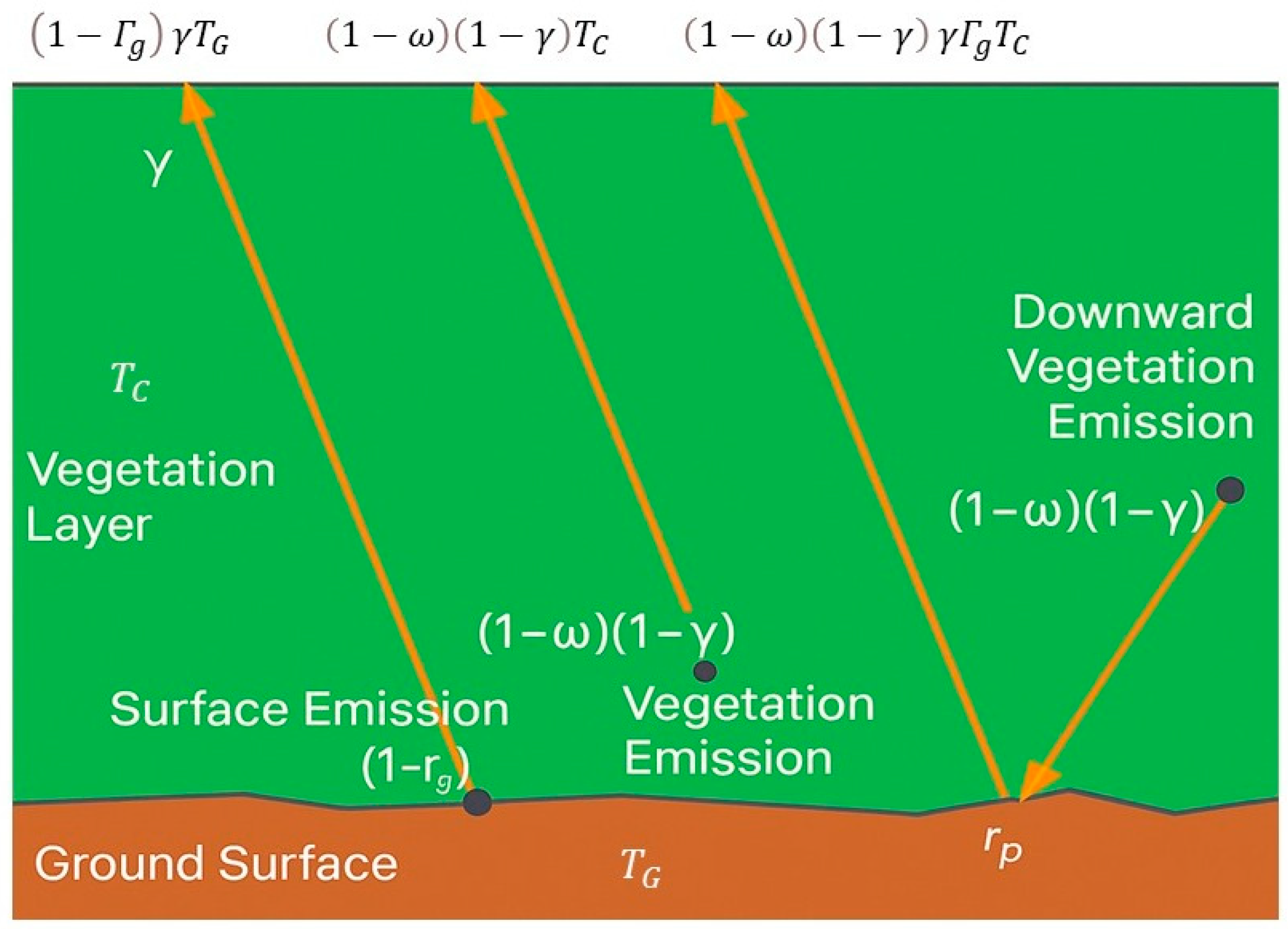
3.2. Zero-Order Solution of Radiative Transfer Equation for Vegetated Surfaces
3.3. Scattering Solution of Radiative Transfer Equation for Vegetated Surfaces
- Canopy decomposition into individual elements with selected canonical shapes.
- Electromagnetic characterization of each element, including its complex permittivity, extinction cross section, and scattering cross section.
- Integration of contributions from all elements to simulate the overall microwave emission and scattering from the canopy–soil system.
3.4. Relevant Adaptations for Vegetated Surfaces
3.5. RT Solutions for Snow Covered and Ice Surfaces
3.6. Summary of RT Approaches for Vegetated and Snow/Ice Covered Surfaces
4. Passive Microwave Remote Sensing for Retrieval of Surface Variables
4.1. Soil Moisture
4.2. Surface Temperature
4.3. Vegetation Optical Depth
4.4. Vegetation Properties
4.5. Snow Cover and Ice Monitoring
4.6. Surface Freeze–Thaw State
4.7. Flood Monitoring
5. Data Assimilation Methodologies for Passive Microwave Remote Sensing
5.1. Data Assimilation Methodologies Applied to Passive Microwave Remote Sensing Data
5.1.1. Ensemble Kalman Filter and Variants
5.1.2. Extended Kalman Filter (EKF)
5.1.3. Particle Filters and Smoothers
5.1.4. Hybrid and Advanced Approaches
- Downscaling: Random forest and neural network models downscale coarse (∼36 km) PMW soil moisture to 5–10 km resolution using terrain, vegetation, and soil properties as predictors [361].
- Observation operator emulation: ML models emulate RT relationships (e.g., LAI–VOD mapping), accelerating forward simulations without compromising accuracy [362].
- Multi-mission fusion: ML algorithms integrate SMAP, SMOS, and AMSR-2 datasets into unified, bias-corrected products for assimilation [362].
5.2. Applications in Earth System Models
5.2.1. Land Surface Models
5.2.2. Cryosphere Models
5.2.3. Coupled Land–Atmosphere Systems
5.3. Key Challenges, Limitations, and Recent Advances in Passive Microwave Data Assimilation
Future Directions
6. Future of Satellite Microwave Radiometry for Land Monitoring
6.1. Copernicus Imaging Microwave Radiometer (CIMR)
6.2. Copernicus Polar Ice and Snow Topography Altimeter
6.3. Advanced Microwave Scanning Radiometer Third Generation
6.4. Cryospheric Radiometer Mission Concept
- Ice-Sheet Stability: CryoRad will provide temperature profiles from the surface to the base of Greenland and Antarctic ice sheets, filling critical observational gaps beyond sparse boreholes and models [375].
- Polar Freshwater Cycle: By halving uncertainties in sea-surface salinity compared to current L-band missions, CryoRad will improve knowledge of high-latitude hydrology and density-driven ocean circulation.
6.5. Fine-Resolution Explorer for Salinity, Carbon, and Hydrology
6.6. Sea-Air-Ice-Land INteractions
7. Conclusions
Author Contributions
Funding
Data Availability Statement
Acknowledgments
Conflicts of Interest
References
- Ulaby, F.T.; Kouyate, F.; Fung, A.K.; Sieber, A.J. A Backscatter Model for a Randomly Perturbed Periodic Surface. IEEE Trans. Geosci. Remote Sens. 1982, 4, 518–528. [Google Scholar] [CrossRef] [Scilit]
- Ulaby, F.T.; Razani, M.; Dobson, M.C. Effects of Vegetation Cover on the Microwave Radiometric Sensitivity to Soil Moisture. IEEE Trans. Geosci. Remote Sens. 1983, 1, 51–61. [Google Scholar] [CrossRef] [Scilit]
- Jenson, J. Remote Sensing of the Environment: An Earth Resource Perspective, 2nd ed.; Pearson Prentice Hall: Upper Saddle River, NJ, USA, 2006; p. 656. [Google Scholar]
- Schär, C.; Fuhrer, O.; Arteaga, A.; Ban, N.; Charpilloz, C.; Di Girolamo, S.; Hentgen, L.; Hoefler, T.; Lapillonne, X.; Leutwyler, D.; et al. Kilometer-scale climate models: Prospects and challenges. Bull. Am. Meteorol. Soc. 2020, 101, E567–E587. [Google Scholar] [CrossRef] [Scilit]
- Ulaby, F.T.; Moore, R.K.; Fung, A.K. Microwave Remote Sensing: Active and Passive; Artech House: Norwood, MA, USA, 1986; Volume III. [Google Scholar]
- Kerr, Y.H.; Waldteufel, P.; Richaume, P.; Wigneron, J.P.; Ferrazzoli, P.; Mahmoodi, A.; Al Bitar, A.; Cabot, F.; Gruhier, C.; Juglea, S.E.; et al. The SMOS soil moisture retrieval algorithm. IEEE Trans. Geosci. Remote Sens. 2012, 50, 1384–1403. [Google Scholar] [CrossRef] [Scilit]
- Roy, A.; Royer, A.; Hall, R.J. Relationship between forest microwave transmissivity and structural parameters for the Canadian boreal forest. IEEE Geosci. Remote Sens. Lett. 2014, 11, 1802–1806. [Google Scholar] [CrossRef] [Scilit]
- Roy, A.; Royer, A.; Wigneron, J.P.; Langlois, A.; Bergeron, J.; Cliche, P. A simple parameterization for a boreal forest radiative transfer model at microwave frequencies. Remote Sens. Environ. 2012, 124, 371–383. [Google Scholar] [CrossRef] [Scilit]
- Mo, T.; Choudhury, B.J.; Schmugge, T.J.; Wang, J.R.; Jackson, T.J. A model for microwave emission from vegetation-covered fields. J. Geophys. Res. Oceans 1982, 87, 11229–11237. [Google Scholar] [CrossRef] [Scilit]
- El-Rayes, M.A.; Ulaby, F.T. Microwave dielectric spectrum of vegetation-Part I: Experimental observations. IEEE Trans. Geosci. Remote Sens. 1987, GE-25, 541–549. [Google Scholar] [CrossRef] [Scilit]
- Huang, H.; Tsang, L.; Njoku, E.G.; Colliander, A.; Liao, T.H.; Ding, K.H. Propagation and scattering by a layer of randomly distributed dielectric cylinders using Monte Carlo simulations of 3D Maxwell equations with applications in microwave interactions with vegetation. IEEE Access 2017, 5, 11985–12003. [Google Scholar] [CrossRef] [Scilit]
- Picard, G.; Sandells, M.; Löwe, H. SMRT: An active–passive microwave radiative transfer model for snow with multiple microstructure and scattering formulations (v1. 0). Geosci. Model Dev. 2018, 11, 2763–2788. [Google Scholar] [CrossRef] [Scilit]
- Wigneron, J.-P.; Kerr, Y.; Waldteufel, P.; Saleh, K.; Escorihuela, M.-J.; Richaume, P.; Ferrazzoli, P.; de Rosnay, P.; Gurney, R.; Calvet, J.-C.; et al. L-band Microwave Emission of the Biosphere (L-MEB) Model: Description and calibration against experimental data sets over crop fields. Remote Sens. Environ. 2007, 107, 639–655. [Google Scholar] [CrossRef] [Scilit]
- Henderson, F.M.; Lewis, A.J. Principles and Applications of Imaging Radar. In Manual of Remote Sensing; John Wiley & Sons: Hoboken, NJ, USA, 1998; Volume 2. [Google Scholar]
- Du, J.; Watts, J.D.; Jiang, L.; Lu, H.; Cheng, X.; Duguay, C.; Farina, M.; Qiu, Y.; Kim, Y.; Kimball, J.S.; et al. Remote Sensing of Environmental Changes in Cold Regions: Methods, Achievements and Challenges. Remote Sens. 2019, 11, 1952. [Google Scholar] [CrossRef] [Scilit]
- Basharinov, A.E.; Gurvich, A.S.; Egorov, S.T. Determination of Geophysical Parameters from Thermal Radio Emission Measurements on the Artificial Earth Satellite ‘Cosmos-243’. Dokl. Akad. Nauk 1969, 188, 1273–1276. Available online: https://mi.mathnet.ru/dan34978 (accessed on 6 November 2025).
- Basharinov, A.E.; Yegorov, S.T.; Gurvich, A.S.; Obukhov, A.M. Some Results of Microwave Sounding of the Atmosphere and Ocean from the Satellite Cosmos 243. Space Res. 1971, 11, 593–600. [Google Scholar]
- Staelin, D.; Barrett, A.; Waters, J.; Barath, F.; Johnston, E.; Rosenkranz, P.; Gaut, N.; Lenoir, W. Microwave Spectrometer on the Nimbus 5 Satellite: Meteorological and Geophysical Data. Science 1973, 182, 1339–1341. [Google Scholar] [CrossRef] [Scilit]
- Schmugge, T.; Gloersen, P.; Wilheit, T.; Geiger, F. Remote sensing of soil moisture with microwave radiometers. J. Geophys. Res. 1974, 79, 317–323. [Google Scholar] [CrossRef] [Scilit]
- Schmugge, T.; Wilheit, T.T.; Gloersen, P.; Meier, M.F.; Frank, D.; Dirmhirn, I. Microwave Signatures of Snow and Fresh Water Ice; NASA Technical Memorandum X-70515; NASA Goddard Space Flight Center: Greenbelt, MD, USA, 1973. [Google Scholar]
- Gorbunov, M.E.; Kutuza, B.G. The Cosmos-243 as the Starting Point for the Development of Microwave Radiometry Methods of the Earth’s Atmosphere and Surface. Izv. Atmos. Ocean. Phys. 2018, 54, 275–281. [Google Scholar] [CrossRef] [Scilit]
- Eagleman, J.R.; Lin, W.C. Remote sensing of soil moisture by a 21-cm passive radiometer. J. Geophys. Res. 1976, 81, 3660–3666. [Google Scholar] [CrossRef] [Scilit]
- Jackson, T.J.; Schmugge, T.J.; Wang, J.R. Passive microwave sensing of soil moisture under vegetation canopies. Water Resour. Res. 1982, 18, 1137–1142. [Google Scholar] [CrossRef] [Scilit]
- Wang, J.R.; O’Neill, P.E.; Jackson, T.J.; Engman, E.T. Multifrequency measurements of the effects of soil moisture, soil texture, and surface roughness. IEEE Trans. Geosci. Remote Sens. 1983, GE-21, 44–51. [Google Scholar] [CrossRef] [Scilit]
- Van de Griend, A.A.; Owe, M. Bare soil surface resistance to evaporation by vapor diffusion under semiarid conditions. Water Resour. Res. 1994, 30, 181–188. [Google Scholar] [CrossRef] [Scilit]
- Kerr, Y.H.; Waldteufel, P.; Wigneron, J.P.; Martinuzzi, J.A.M.J.; Font, J.; Berger, M. Soil moisture retrieval from space: The Soil Moisture and Ocean Salinity (SMOS) mission. IEEE Trans. Geosci. Remote Sens. 2001, 39, 1729–1735. [Google Scholar] [CrossRef] [Scilit]
- Kerr, Y.H.; Waldteufel, P.; Wigneron, J.-P.; Delwart, S.; Cabot, F.; Boutin, J.; Escorihuela, M.-J.; Font, J.; Reul, N.; Gruhier, C.; et al. The SMOS mission: New tool for monitoring key elements of the global water cycle. Proc. IEEE 2010, 98, 666–687. [Google Scholar] [CrossRef] [Scilit]
- English, S.; McNally, T.; Bormann, N.; Salonen, K.; Matricardi, M.; Moranyi, A.; Rennie, M.; Janisková, M.; Di Michele, S.; Geer, A.; et al. Impact of Satellite Data; ECMWF: Bonn, Germany, 2013. [Google Scholar]
- Schmugge, T. Remote Sensing of Snow and Evapotranspiration; (No. NASA-CP-2363); NASA: Washington, DC, USA, 1985.
- Ulaby, F.T.; Moore, R.K.; Fung, A.K. Microwave Remote Sensing: Active and Passive; Addison-Wesley Publishing Company: Reading, MA, USA, 1981; Volume 1. [Google Scholar]
- Dobson, M.C.; Ulaby, F.T. Active microwave soil moisture research. IEEE Trans. Geosci. Remote Sens. 1986, GE-24, 23–36. [Google Scholar] [CrossRef] [Scilit]
- Njoku, E.G.; Entekhabi, D. Passive microwave remote sensing of soil moisture. J. Hydrol. 1996, 184, 101–129. [Google Scholar] [CrossRef] [Scilit]
- Ulaby, F.T.; Dubois, P.C.; Van Zyl, J. Radar mapping of surface soil moisture. J. Hydrol. 1996, 184, 57–84. [Google Scholar] [CrossRef] [Scilit]
- Ferrazzoli, P.; Paloscia, S.; Pampaloni, P.; Schiavon, G.; Solimini, D.; Coppo, P. Sensitivity of microwave measurements to vegetation biomass and soil moisture content: A case study. IEEE Trans. Geosci. Remote Sens. 1992, 30, 750–756. [Google Scholar] [CrossRef] [Scilit]
- Wigneron, J.P.; Calvet, J.C.; Kerr, Y.; Chanzy, A.; Lopes, A. Microwave emission of vegetation: Sensitivity to leaf characteristics. IEEE Trans. Geosci. Remote Sens. 1993, 31, 716–726. [Google Scholar] [CrossRef] [Scilit]
- Choudhury, B.J.; Schmugge, T.J.; Mo, T. A parameterization of effective soil temperature for microwave emission. J. Geophys. Res. Oceans 1982, 87, 1301–1304. [Google Scholar] [CrossRef] [Scilit]
- Chanzy, A.; Raju, S.; Wigneron, J.P. Estimation of soil microwave effective temperature at L and C bands. IEEE Trans. Geosci. Remote Sens. 1997, 35, 570–580. [Google Scholar] [CrossRef] [Scilit]
- Van de Griend, A.A. The Effective Thermodynamic Temperature of the Emitting Surface at 6.6 GHz and Consequences for Soil Moisture Monitoring from Space. IEEE Trans. Geosci. Remote Sens. 2001, 39, 1673–1679. [Google Scholar] [CrossRef]
- Mätzler, C. Passive microwave signatures of landscapes in winter. Meteorol. Atmos. Phys. 1994, 54, 241–260. [Google Scholar] [CrossRef] [Scilit]
- Pulliainen, J.; Hallikainen, M. Retrieval of regional snow water equivalent from space-borne passive microwave observations. Remote Sens. Environ. 2001, 75, 76–85. [Google Scholar] [CrossRef] [Scilit]
- Mo, T.; Schmugge, T.J. A parameterization of the effect of surface roughness on microwave emission. IEEE Trans. Geosci. Remote Sens. 1987, GE-25, 481–486. [Google Scholar] [CrossRef] [Scilit]
- Chang, A.T.C.; Foster, J.L.; Hall, D.K. Microwave snow signatures (1.5 mm to 3 cm) over Alaska. Cold Reg. Sci. Technol. 1987, 13, 153–160. [Google Scholar] [CrossRef] [Scilit]
- Künzi, K.F.; Patil, S.; Rott, H. Remote Sensing of Snow Cover with Space-Borne Microwave Radiometers. IEEE Trans. Geosci. Remote Sens. 1982, GE-20, 41–49. [Google Scholar] [CrossRef] [Scilit]
- Schmugge, T.J. Applications of Passive Microwave Observations of Surface Soil Moisture. J. Hydrometeorol. 2002, 3, 466–472. [Google Scholar]
- Foster, J.L.; Chang, A.T.; Hall, D.K. Comparison of Snow Mass Estimates from Microwave Retrievals and Surface Measurements. J. Hydrol. 1997, 201, 379–389. [Google Scholar]
- Foster, J.L.; Chang, A.T.C.; Hall, D.K. Comparison of snow mass estimates from a prototype passive microwave snow algorithm, a revised algorithm and a snow depth climatology. Remote Sens. Environ. 1997, 62, 132–142. [Google Scholar] [CrossRef] [Scilit]
- Pulliainen, J.; Grandell, J.; Hallikainen, M. HUT Snow Emission Model and Its Applicability to Snow Water Equivalent Retrieval. IEEE Trans. Geosci. Remote Sens. 1999, 37, 761–770. [Google Scholar] [CrossRef] [Scilit]
- Wilson, L.L.; Tsang, L.; Hwang, J.N.; Chen, C.T. Mapping snow water equivalent by combining a spatially distributed snow hydrology model with passive microwave remote-sensing data. IEEE Trans. Geosci. Remote Sens. 1999, 37, 690–704. [Google Scholar] [CrossRef]
- Chang, A.T.; Foster, J.L.; Hall, D.K.; Rango, A.; Hartline, B.K. Snow water equivalent estimation by microwave radiometry. Cold Reg. Sci. Technol. 1982, 5, 259–267. [Google Scholar] [CrossRef] [Scilit]
- Tedesco, M.; Fettweis, X.; van den Broeke, M.R.; van de Wal, R.S.W.; Smeets, C.J.P.P.; van de Berg, W.J.; Serreze, M.C.; Box, J.E. The Role of Albedo and Accumulation in the 2012 Melt Record in Greenland. Environ. Res. Lett. 2018, 8, 014005. [Google Scholar] [CrossRef] [Scilit]
- Tedesco, M.; Narvekar, P.S. Assessment of the NASA AMSR-E SWE Product. IEEE J. Sel. Top. Appl. Earth Obs. Remote Sens. 2010, 3, 497–507. [Google Scholar] [CrossRef] [Scilit]
- Chang, A.T.C.; Foster, J.L.; Hall, D.K. Nimbus-7 SMMR Derived Global Snow Cover Parameters. Ann. Glaciol. 1987, 9, 39–44. [Google Scholar] [CrossRef] [Scilit] [PubMed]
- Comiso, J.C. A Rapidly Declining Perennial Sea Ice Cover in the Arctic. Geophys. Res. Lett. 1999, 26, 387–390. [Google Scholar]
- Cavalieri, D.J.; Parkinson, C.L.; Gloersen, P.; Zwally, H.J. A Long-Term Data Record of Sea Ice Concentration from Passive Microwave Radiometry. J. Geophys. Res. Oceans 2003, 108, 3088. [Google Scholar]
- Markus, T.; Cavalieri, D.J. An Enhancement of the NASA Team Sea Ice Algorithm. IEEE Trans. Geosci. Remote Sens. 2000, 38, 1383–1396. [Google Scholar] [CrossRef] [Scilit]
- Eppler, D.T.; Farmer, L.D.; Grenfell, T.C.; Mätzler, C.; Lohanick, R.B.; Svendsen, E.; Comiso, J.C. Passive Microwave Signatures of Sea Ice. In Microwave Remote Sensing of Sea Ice; Frank, D.C., Ed.; Geophysical Monograph; American Geophysical Union: Washington, DC, USA, 1992; pp. 47–71. [Google Scholar] [CrossRef] [Scilit]
- Heygster, G.; Huntemann, M.; Kaleschke, L.; Drusch, M. Sea Ice Thickness Retrieval in the Fram Strait Using Passive Microwave Sensors. In Proceedings of the IEEE International Symposium on Geoscience and Remote Sensing (IGARSS), Cape Town, South Africa, 12–17 July 2009. [Google Scholar]
- Kaleschke, L.; Tian-Kunze, X.; Maaß, N.; Mäkynen, M.; Drusch, M. Sea ice thickness retrieval from SMOS brightness temperatures during the Arctic freeze-up period. Geophys. Res. Lett. 2012, 39, L05501. [Google Scholar] [CrossRef] [Scilit]
- Tsang, L.; Kong, J.A.; Ding, K.H. Scattering of Electromagnetic Waves: Theories and Applications; Wiley: New York, NY, USA, 2001. [Google Scholar] [CrossRef] [Scilit]
- Ishimaru, A. Wave Propagation and Scattering in Random Media; Academic Press: New York, NY, USA, 1978. [Google Scholar]
- Ulaby, F.T.; Long, D.G.; Fung, A.K.; Moore, R.K. Microwave Emission and Scattering Models for Vegetation. IEEE Trans. Geosci. Remote Sens. 1990, 28, 800–810. [Google Scholar]
- Peterson, B.; Ström, S. T-matrix approach to the multiple scattering of waves by N scatterers. J. Acoust. Soc. Am. 1973, 54, 156–160. [Google Scholar]
- Tsang, L.; Kong, J.A.; Shin, R.T. Theory of Microwave Remote Sensing; Wiley-Interscience: New York, NY, USA, 1985. [Google Scholar]
- Doicu, A.; Mishchenko, M.I. An overview of methods for deriving the radiative transfer theory from the Maxwell equations. II: Approach based on the Dyson and Bethe-Salpeter equations. J. Quant. Spectrosc. Radiat. Transf. 2019, 224, 25–36. [Google Scholar] [CrossRef] [Scilit] [PubMed]
- Furutsu, K. Multiple scattering of waves in a medium of randomly distributed particles and derivation of the transport equation. Radio Sci. 1975, 10, 29–44. [Google Scholar] [CrossRef] [Scilit]
- Chandrasekhar, S. Radiative Transfer; Dover Publications: New York, NY, USA, 1960. [Google Scholar]
- Ulaby, F.T.; Long, D.G. Microwave Radar and Radiometric Remote Sensing, 1st ed.; University of Michigan Press: Ann Arbor, MI, USA, 2015; ISBN 978-0-472-11935-6. [Google Scholar]
- Tsang, L.; Kong, J.A. Scattering of Electromagnetic Waves, Vol. 3: Advanced Topics; Wiley-Interscience: New York, NY, USA, 2001; p. Circa 413. [Google Scholar] [CrossRef] [Scilit]
- Kuga, Y.; Ishimaru, A. Retroreflectance from a dense distribution of spherical particles. J. Opt. Soc. Am. A 1984, 1, 831–835. [Google Scholar] [CrossRef] [Scilit]
- Tsang, L.; Ishimaru, A. Backscattering enhancement of random discrete scatterers. J. Opt. Soc. Am. A 1984, 1, 836–839. [Google Scholar] [CrossRef] [Scilit]
- Mishchenko, M.I.; Travis, L.D.; Lacis, A.A. Multiple Scattering of Light by Particles: Radiative Transfer and Coherent Backscattering; Cambridge University Press: Cambridge, UK, 2006. [Google Scholar]
- Peterson, A.F.; Ström, S. T-matrix formulation of electromagnetic scattering from an arbitrary number of scatterers with continuously varying electromagnetic properties. Phys. Rev. D 1973, 8, 3661–3678. [Google Scholar] [CrossRef] [Scilit]
- Mishchenko, M.I.; Hovenier, J.W.; Travis, L.D. Light Scattering by Nonspherical Particles; Academic Press: San Diego, CA, USA, 2000. [Google Scholar] [CrossRef] [Scilit]
- Du, Y.; Tsang, L.; Huang, X.; Zhang, C.; Li, Z.; Ding, K.H. Electromagnetic Scattering by Densely Packed Spheres: Improved Modeling with Combined MST and RT. IEEE Trans. Geosci. Remote Sens. 2011, 49, 70–84. [Google Scholar]
- Nagler, T.; Rott, H. Retrieval of wet snow by means of multitemporal SAR data. IEEE Trans. Geosci. Remote Sens. 2000, 38, 754–765. [Google Scholar] [CrossRef] [Scilit]
- Takala, M.; Luojus, K.; Pulliainen, J.; Derksen, C.; Lemmetyinen, J.; Kärnä, J.P.; Koskinen, J.; Bojkov, B. Estimating northern hemisphere snow water equivalent for climate research through assimilation of space-borne radiometer data and ground-based measurements. Remote Sens. Environ. 2011, 115, 3517–3529. [Google Scholar] [CrossRef] [Scilit]
- Lievens, H.; Demuzere, M.; Marshall, H.-P.; Reichle, R.H.; Brucker, L.; Brangers, I.; de Rosnay, P.; Dumont, M.; Girotto, M.; Immerzeel, W.W.; et al. Snow depth variability in the Northern Hemisphere mountains observed from space. Nat. Commun. 2019, 10, 4629. [Google Scholar] [CrossRef] [Scilit]
- Konings, A.G.; Piles, M.; Das, N.; Entekhabi, D. L-band vegetation optical depth and effective scattering albedo estimation from SMAP. Remote Sens. Environ. 2017, 198, 460–470. [Google Scholar] [CrossRef] [Scilit]
- Konings, A.G.; Piles, M.; Rötzer, K.; McColl, K.A.; Chan, S.K.; Entekhabi, D. Vegetation Optical Depth and Scattering Albedo Retrieval Using Time Series of Dual-Polarized L-band Radiometer Observations. Remote Sens. Environ. 2017, 190, 94–106. [Google Scholar]
- Konings, A.G.; Rao, K.; Steele-Dunne, S.C. Macro to Micro: Microwave Remote Sensing of Plant Water Content for Physiology and Ecology. New Phytol. 2019, 223, 1166–1172. [Google Scholar] [CrossRef] [Scilit] [PubMed]
- Mialon, A.; Rodríguez-Fernández, N.J.; Santoro, M.; Saatchi, S.; Mermoz, S.; Bousquet, E.; Kerr, Y.H. Evaluation of the sensitivity of SMOS L-VOD to forest above-ground biomass at global scale. Remote Sens. 2020, 12, 1450. [Google Scholar] [CrossRef] [Scilit]
- Colliander, A.; Jackson, T.J.; Bindlish, R.; Chan, S.; Das, N.; Kim, S.B.; Cosh, M.H.; Dunbar, R.S.; Dang, L.; Pashaian, L.; et al. Validation of SMAP surface soil moisture products with core validation sites. Remote Sens. Environ. 2017, 191, 215–231. [Google Scholar] [CrossRef] [Scilit]
- Kim, Y.; Kimball, J.S.; Zhang, K.; McDonald, K.C. Satellite detection of increasing Northern Hemisphere non-frozen seasons from 1979 to 2008: Implications for regional vegetation growth. Remote Sens. Environ. 2012, 121, 472–487. [Google Scholar] [CrossRef] [Scilit]
- Roy, A.; Royer, A.; Derksen, C.; Brucker, L.; Langlois, A.; Mialon, A.; Kerr, Y.H. Evaluation of spaceborne L-band radiometer measurements for terrestrial freeze/thaw retrievals in Canada. IEEE J. Sel. Top. Appl. Earth Obs. Remote Sens. 2015, 8, 4442–4459. [Google Scholar] [CrossRef] [Scilit]
- Rautiainen, K.; Parkkinen, T.; Lemmetyinen, J.; Schwank, M.; Wiesmann, A.; Ikonen, J.; Derksen, C.; Davydov, S.; Davydova, A.; Boike, J.; et al. SMOS prototype algorithm for detecting autumn soil freezing. Remote Sens. Environ. 2016, 180, 346–360. [Google Scholar] [CrossRef] [Scilit]
- Derksen, C.; Xu, X.; Dunbar, R.S.; Colliander, A.; Kim, Y.; Kimball, J.S.; Black, T.A.; Euskirchen, E.; Langlois, A.; Loranty, M.M.; et al. Retrieving landscape freeze/thaw state from Soil Moisture Active Passive (SMAP) radar and radiometer measurements. Remote Sens. Environ. 2017, 194, 48–62. [Google Scholar] [CrossRef] [Scilit]
- Prince, M.; Roy, A.; Brucker, L.; Royer, A.; Kim, Y.; Zhao, T. Northern Hemisphere surface freeze-thaw product from Aquarius L-band radiometers. Earth Syst. Sci. Data 2018, 10, 2055–2067. [Google Scholar] [CrossRef] [Scilit]
- Entekhabi, D.; Njoku, E.G.; O’Neill, P.E.; Kellogg, K.H.; Crow, W.T.; Edelstein, W.N.; Entin, J.K.; Goodman, S.D.; Jackson, T.J.; Johnson, J.; et al. The Soil Moisture Active Passive (SMAP) Mission. Proc. IEEE 2010, 98, 704–716. [Google Scholar] [CrossRef] [Scilit]
- Jackson, T.J.; Schmugge, T.J. Vegetation effects on the microwave emission of soils. Remote Sens. Environ. 1991, 36, 203–212. [Google Scholar] [CrossRef] [Scilit]
- Wigneron, J.P.; Jackson, T.J.; Bosch, D.D.; Daughtry, C.S. An analysis of the relationship between vegetation optical depth and vegetation water content. IEEE Trans. Geosci. Remote Sens. 2004, 42, 1489–1502. [Google Scholar]
- Vittucci, C.; Ferrazzoli, P.; Kerr, Y.; Richaume, P.; Guerriero, L.; Rahmoune, R.; Laurin, G.V. SMOS Retrieval over Forests: Exploitation of Optical Depth and Tests of Soil Moisture Estimates. Remote Sens. Environ. 2016, 180, 115–127. [Google Scholar] [CrossRef] [Scilit]
- Vittucci, C.; Laurin, G.V.; Tramontana, G.; Ferrazzoli, P.; Guerriero, L.; Papale, D. Vegetation Optical Depth at L-Band and Above Ground Biomass in the Tropical Range: Evaluating Their Relationships at Continental and Regional Scales. Int. J. Appl. Earth Obs. Geoinf. 2019, 77, 151–161. [Google Scholar] [CrossRef] [Scilit]
- Ferrazzoli, P.; Guerriero, L. Passive microwave remote sensing of forests: A model investigation. IEEE Trans. Geosci. Remote Sens. 1996, 34, 433–443. [Google Scholar] [CrossRef] [Scilit]
- Disney, M.; Lewis, P.; North, P. Monte Carlo Ray Tracing in Optical Canopy Reflectance Modelling. Remote Sens. Rev. 2000, 18, 163–196. [Google Scholar] [CrossRef] [Scilit]
- Lang, R.H. Electromagnetic backscattering from a sparse distribution of lossy dielectric scatterers. Radio Sci. 1981, 16, 15–30. [Google Scholar] [CrossRef] [Scilit]
- LeVine, D.M.; Meneghini, R.; Lang, R.H.; Seker, S.S. Scattering from arbitrarily oriented dielectric disks in the physical optics regime. J. Opt. Soc. Am. 1983, 73, 1255–1262. [Google Scholar] [CrossRef] [Scilit]
- LeVine, D.M.; Lang, R.H.; Meneghini, R.; Seker, S.S. The influence of vegetation on the microwave scattering from a soil surface. IEEE Trans. Geosci. Remote Sens. 1985, 23, 371–379. [Google Scholar]
- Seker, S.S.; Schneider, J.M. Scattering from a lossy dielectric cylinder of finite length. IEEE Trans. Geosci. Remote Sens. 1988, 26, 377–386. [Google Scholar]
- Karam, M.A.; Fung, A.K.; Antar, Y.M. Electromagnetic wave scattering from some vegetation samples. IEEE Trans. Geosci. Remote Sens. 1988, 26, 799–808. [Google Scholar] [CrossRef] [Scilit]
- Bracaglia, M.; Ferrazzoli, P.; Guerriero, L. A fully polarimetric multiple scattering model for crops. Remote Sens. Environ. 1995, 54, 170–179. [Google Scholar] [CrossRef] [Scilit]
- Chauhan, N.S.; Lang, R.H. Radar backscattering from alfalfa canopy: A clump modelling approach. Int. J. Remote Sens. 1999, 20, 2203–2220. [Google Scholar] [CrossRef] [Scilit]
- Chiu, T.; Sarabandi, K. Electromagnetic scattering from short branching vegetation. IEEE Trans. Geosci. Remote Sens. 2000, 38, 911–925. [Google Scholar] [CrossRef] [Scilit]
- Della Vecchia, A.; Ferrazzoli, P.; Guerriero, L. Modelling microwave scattering from long curved leaves. Waves Random Media 2004, 14, S333. [Google Scholar] [CrossRef] [Scilit]
- Fung, A.K.; Shah, M.R.; Tjuatja, S. Numerical simulation of scattering from three-dimensional randomly rough surfaces. IEEE Trans. Geosci. Remote Sens. 1994, 32, 986–994. [Google Scholar] [CrossRef] [Scilit]
- Cookmartin, G.; Saich, P.; Quegan, S.; Cordey, R.; Burgess-Allen, P.; Sowter, A. Modeling microwave interactions with crops and comparison with ERS-2 SAR observations. IEEE Trans. Geosci. Remote Sens. 2000, 38, 658–670. [Google Scholar] [CrossRef] [Scilit]
- Del Frate, F.; Ferrazzoli, P.; Schiavon, G. Retrieving soil moisture and agricultural variables by microwave radiometry using neural networks. Remote Sens. Environ. 2003, 84, 174–183. [Google Scholar] [CrossRef] [Scilit]
- Kasischke, E.S.; Christensen, N.L.; Bourgeau-Chavez, L.L. Correlating radar backscatter with components of biomass in loblolly pine forests. IEEE Trans. Geosci. Remote Sens. 1995, 33, 643–659. [Google Scholar] [CrossRef] [Scilit]
- Saleh, K.; Wigneron, J.P.; Grant, J.P.; Kerr, Y.H.; Calvet, J.C. Use of a vegetation model to support the SMOS mission. Hydrol. Earth Syst. Sci. 2005, 9, 268–283. [Google Scholar]
- Wigneron, J.P.; Chanzy, A.; Kerr, Y.H.; Lawrence, H.; Shi, J.; Escorihuela, M.J.; Mironov, V.; Mialon, A.; Demontoux, F.; De Rosnay, P.; et al. Evaluating an Improved Parameterization of the Soil Emission in L-MEB. IEEE Trans. Geosci. Remote Sens. 2011, 49, 1177–1189. [Google Scholar] [CrossRef] [Scilit]
- Ulaby, F.T.; El-Rayes, M.A. Microwave dielectric spectrum of vegetation-Part II: Dual-dispersion model for leaf and stem water. IEEE Trans. Geosci. Remote Sens. 1987, 25, 550–557. [Google Scholar] [CrossRef] [Scilit]
- Gu, W.; Tsang, L.; Colliander, A.; Yueh, S. Hybrid method for full-wave simulations of forests at L-band. IEEE Access 2022, 10, 105898–105909. [Google Scholar] [CrossRef] [Scilit]
- Richards, J.A. Microwave Remote Sensing of Land Surfaces; Taylor & Francis: London, UK, 1990. [Google Scholar]
- Macelloni, G.; Paloscia, S.; Pampaloni, P.; Ruisi, R. Airborne multifrequency L-to Ka-band radiometric measurements over forests. IEEE Trans. Geosci. Remote Sens. 2001, 39, 2507–2513. [Google Scholar] [CrossRef] [Scilit]
- Kurum, M.; Lang, R.H.; O’Neill, P.; Joseph, A.; Jackson, T.; Cosh, M. A First-Order Radiative Transfer Model for Microwave Radiometry of Forest Canopies at L-Band. IEEE Trans. Geosci. Remote Sens. 2011, 49, 3167–3179. [Google Scholar] [CrossRef] [Scilit]
- McDonald, K.C.; Ulaby, F.T.; Dobson, M.C.; Cihlar, J. Modeling the backscatter of a discontinuous tree canopy. IEEE Trans. Geosci. Remote Sens. 1990, 28, 807–822. [Google Scholar] [CrossRef] [Scilit]
- McDonald, K.C.; Ulaby, F.T.; Cihlar, J.; Dobson, M.C. Microwave backscatter modeling of discontinuous forest canopies. IEEE Trans. Geosci. Remote Sens. 1991, 29, 518–527. [Google Scholar] [CrossRef] [Scilit]
- Twomey, S.; Jacobowitz, H.; Howell, H.B. Matrix methods for multiple-scattering problems. J. Atmos. Sci. 1966, 23, 289–298. [Google Scholar] [CrossRef] [Scilit]
- Eom, H.J.; Fung, A.K. A scatter model for vegetation up to Ku-band. Remote Sens. Environ. 1984, 15, 185–200. [Google Scholar] [CrossRef] [Scilit]
- Ferrazzoli, P.; Guerriero, L. Radar sensitivity to tree geometry and woody volume: A model analysis. IEEE Trans. Geosci. Remote Sens. 1995, 33, 360–371. [Google Scholar] [CrossRef] [Scilit]
- Ferrazzoli, P.; Guerriero, L.; Wigneron, J.P. Simulating L-band emission of forests in view of future satellite applications. IEEE Trans. Geosci. Remote Sens. 2002, 40, 2700–2708. [Google Scholar] [CrossRef] [Scilit]
- Della Vecchia, A.; Ferrazzoli, P.; Wigneron, J.P.; Grant, J.P. Modeling forest emissivity at L-band and a comparison with multitemporal measurements. IEEE Geosci. Remote Sens. Lett. 2007, 4, 508–512. [Google Scholar] [CrossRef] [Scilit]
- Della Vecchia, A.; Ferrazzoli, P.; Guerriero, L.; Rahmoune, R.; Paloscia, S.; Pettinato, S.; Santi, E. Modeling the multifrequency emission of broadleaf forests and their components. IEEE Trans. Geosci. Remote Sens. 2009, 48, 260–272. [Google Scholar] [CrossRef]
- Grant, J.P.; Saleh-Contell, K.; Wigneron, J.P.; Guglielmetti, M.; Kerr, Y.H.; Schwank, M.; Skou, N.; Van de Griend, A.A. Calibration of the L-MEB model over a coniferous and a deciduous forest. IEEE Trans. Geosci. Remote Sens. 2008, 46, 808–818. [Google Scholar] [CrossRef]
- Kurum, M.; O’Neill, P.E.; Lang, R.H.; Joseph, A.T.; Cosh, M.H.; Jackson, T.J. Effective tree scattering and opacity at L-band. Remote Sens. Environ. 2012, 118, 1–9. [Google Scholar] [CrossRef] [Scilit]
- Mätzler, C.; Wegmüller, U. Dielectric properties of fresh-water ice at microwave frequencies. J. Phys. D Appl. Phys. 1988, 21, 1660. [Google Scholar] [CrossRef] [Scilit]
- Denoth, A. Snow dielectric measurements. Adv. Space Res. 1989, 9, 233–243. [Google Scholar] [CrossRef] [Scilit]
- Chang, T.C.; Gloersen, P.; Schmugge, T.; Wilheit, T.T.; Zwally, H.J. Microwave Emission from Snow and Glacier Ice. J. Glaciol. 1976, 16, 23–39. [Google Scholar] [CrossRef] [Scilit]
- Bernier, P.Y. Microwave remote sensing of snowpack properties: Potential and limitations. Hydrol. Res. 1987, 18, 1–20. [Google Scholar] [CrossRef] [Scilit]
- Lakhankar, T.; Azar, A.E.; Shahroudi, N.; Powell, A.; Khanbilvardi, R. Analysis of the Effects of Snowpack Properties on Satellite Microwave Brightness Temperature and Emissivity Data; City University of New York: New York, NY, USA, 2012. [Google Scholar] [CrossRef]
- Hallikainen, M.; Ulaby, F.; Abdelrazik, M. Dielectric Properties of Snow in the 3 to 37 GHz Range. IEEE Trans. Antennas Propag. 1986, 34, 1329–1340. [Google Scholar] [CrossRef] [Scilit]
- Wiesmann, A.; Mätzler, C. Microwave Emission Model of Layered Snowpacks. Remote Sens. Environ. 1999, 70, 307–316. [Google Scholar] [CrossRef] [Scilit]
- Tsang, L.; Kong, J.A. Scattering of Electromagnetic Waves from a Dense Medium Consisting of Correlated Mie Scatterers with Size Distributions and Applications to Dry Snow. J. Electromagn. Wave Appl. 1992, 6, 265–286. [Google Scholar] [CrossRef] [Scilit]
- Jin, Y.Q. Electromagnetic Scattering Modelling for Quantitative Remote Sensing; World Scientific: Singapore, 1993. [Google Scholar]
- Comiso, J.C. Sea Ice Effective Microwave Emissivities from Satellite Passive Microwave and Infrared Observations. J. Geophys. Res. Oceans 1983, 88, 7686–7704. [Google Scholar] [CrossRef] [Scilit]
- Drinkwater, M.R.; Floury, N.; Tedesco, M. L-Band Ice-Sheet Brightness Temperatures at Dome C, Antarctica: Spectral Emission Modelling, Temporal Stability and Impact of the Ionosphere. Ann. Glaciol. 2004, 39, 391–396. [Google Scholar] [CrossRef] [Scilit]
- Houtz, D.; Mätzler, C.; Naderpour, R.; Schwank, M.; Steffen, K. Quantifying surface melt and liquid water on the Greenland ice sheet using L-band radiometry. Remote Sens. Environ. 2021, 256, 112341. [Google Scholar] [CrossRef] [Scilit]
- Scanlon, T.; Pasik, A.; Dorigo, W.; de Jeu, R.A.M.; Hahn, S.; van der Schalie, R.; Wagner, W.; Kidd, R.; Gruber, A.; Moesinger, L.; et al. ESA Climate Change Initiative Plus—Soil Moisture: Algorithm Theoretical Baseline Document (ATBD); Technical Report D2.1 Version 04.7; Earth Observation Data Centre for Water Resources Monitoring (EODC) GmbH: Vienna, Austria, 2020; Available online: https://dap.ceda.ac.uk/thredds/fileServer/neodc/esacci/soil_moisture/docs/v04.7/ESA_CCI_Soil_Moisture_Algorithm_Theoretical_Basis_Document_ATBD_v04.7.pdf (accessed on 6 November 2025).
- Saberi, N.; Kelly, R.; Flemming, M.; Li, Q. Review of snow water equivalent retrieval methods using spaceborne passive microwave radiometry. Int. J. Remote Sens. 2020, 41, 996–1018. [Google Scholar] [CrossRef] [Scilit]
- Moesinger, L.; Dorigo, W.; De Jeu, R.; Van Der Schalie, R.; Scanlon, T.; Teubner, I.; Forkel, M. The global long-term microwave vegetation optical depth climate archive (VODCA). Earth Syst. Sci. Data 2020, 12, 177–196. [Google Scholar] [CrossRef] [Scilit]
- Calvet, J.C.; Wigneron, J.P.; Walker, J.; Karbou, F.; Chanzy, A.; Albergel, C. Sensitivity of Passive Microwave Observations to Soil Moisture and Vegetation Water Content: L-Band to W-Band. IEEE Trans. Geosci. Remote Sens. 2010, 49, 1190–1199. [Google Scholar] [CrossRef] [Scilit]
- Konings, A.G.; Entekhabi, D.; Chan, S.K.; Njoku, E.G. Effect of Radiative Transfer Uncertainty on L-Band Radiometric Soil Moisture Retrieval. IEEE Trans. Geosci. Remote Sens. 2011, 49, 2686–2698. [Google Scholar] [CrossRef]
- Dorigo, W.; Wagner, W.; Albergel, C.; Albrecht, F.; Balsamo, G.; Brocca, L.; Chung, D.; Ertl, M.; Forkel, M.; Gruber, A.; et al. ESA CCI Soil Moisture for Improved Earth System Understanding: State-of-the Art and Future Directions. Remote Sens. Environ. 2017, 203, 185–215. [Google Scholar] [CrossRef] [Scilit]
- Chan, S.K.; Bindlish, R.; O’Neill, P.E.; Njoku, E.; Jackson, T.; Colliander, A.; Chen, F.; Burgin, M.; Dunbar, S.; Piepmeier, J.; et al. Assessment of the SMAP Passive Soil Moisture Product. IEEE Trans. Geosci. Remote Sens. 2016, 54, 4994–5007. [Google Scholar] [CrossRef] [Scilit]
- Wagner, W.; Dorigo, W.; De Jeu, R.; Fernandez, D.; Benveniste, J.; Haas, E.; Ertl, M. Fusion of Active and Passive Microwave Observations to Create an Essential Climate Variable Data Record on Soil Moisture. ISPRS Ann. Photogramm. Remote Sens. Spat. Inf. Sci. 2012, I-7, 315–321. [Google Scholar] [CrossRef] [Scilit]
- Jiang, D.; Wang, K. The Role of Satellite-Based Remote Sensing in Improving Simulated Streamflow: A Review. Water 2019, 11, 1615. [Google Scholar] [CrossRef] [Scilit]
- Mironov, V.; Savin, I. A temperature-dependent multi-relaxation spectroscopic dielectric model for thawed and frozen organic soil at 0.05-15 GHz. Phys. Chem. Earth Parts A/B/C 2015, 83, 57–64. [Google Scholar] [CrossRef] [Scilit]
- Bircher, S.; Demontoux, F.; Razafindratsima, S.; Zakharova, E.; Drusch, M.; Wigneron, J.P.; Kerr, Y.H. L-band relative permittivity of organic soil surface layers-A new dataset of resonant cavity measurements and model evaluation. Remote Sens. 2016, 8, 1024. [Google Scholar] [CrossRef] [Scilit]
- Das, K.; Paul, P.K. Soil moisture retrieval model by using RISAT-1, C-band data in tropical dry and sub-humid zone of Bankura district of India. Egypt. J. Remote Sens. Space Sci. 2015, 18, 297–310. [Google Scholar] [CrossRef] [Scilit]
- Colliander, A.; Cosh, M.H.; Berg, A.; Misra, S.; Thomas, J.; Bourgeau-Chavez, L.; Kelly, V.; Kraatz, S.; Siqueira, P.; Roy, A.; et al. Development of smap retrievals for forested regions: Smapvex19-22 and smapvex22-boreal. In IGARSS 2022-2022 IEEE International Geoscience and Remote Sensing Symposium; IEEE: Kuala Lumpur, Malaysia, 2022; pp. 4228–4231. [Google Scholar] [CrossRef] [Scilit]
- Zhang, X.; Zhu, J.; Li, S.; Liu, C.; Han, P.; Zhao, Z.; Wang, X. A new dielectric model for frozen organic-rich soils from 0.05 to 1.5 GHz. Remote Sens. Environ. 2023, 285, 113391. [Google Scholar]
- Niu, J.; Li, H.; Zhao, T. Dielectric Behavior of Organic-Rich Soils in Microwave Frequencies. J. Hydrol. 2024, 632, 130–142. [Google Scholar]
- Wigneron, J.-P.; Jackson, T.; O’NEill, P.; De Lannoy, G.; de Rosnay, P.; Ferrazzoli, P.; Mironov, V.; Bircher, S.; Grant, J.; Kurum, M.; et al. Modelling the Passive Microwave Signature from Land Surfaces: A Review of Recent Results and Application to the L-Band SMOS & SMAP Soil Moisture Retrieval Algorithms. Remote Sens. Environ. 2017, 192, 238–262. [Google Scholar] [CrossRef] [Scilit]
- Chaubell, M.J.; Yueh, S.H.; Dunbar, R.S.; Colliander, A.; Chen, F.; Chan, S.K.; Entekhabi, D.; Bindlish, R.; O’Neill, P.E.; Asanuma, J.; et al. Improved SMAP Dual-Channel Algorithm for the Retrieval of Soil Moisture. IEEE Trans. Geosci. Remote Sens. 2020, 58, 3894–3905. [Google Scholar] [CrossRef] [Scilit]
- Schwank, M.; Naderpour, R.; Mätzler, C. “Tau-Omega”-and Two-Stream Emission Models Used for Passive L-Band Retrievals: Application to Close-Range Measurements over a Forest. Remote Sens. 2018, 10, 1868. [Google Scholar] [CrossRef] [Scilit]
- Adams, J.R.; McNairn, H.; Berg, A.A.; Champagne, C. Evaluation of near-surface soil moisture data from an AAFC monitoring network in Manitoba, Canada: Implications for L-band satellite validation. J. Hydrol. 2015, 521, 582–592. [Google Scholar] [CrossRef] [Scilit]
- Engman, E.T. Applications of microwave remote sensing of soil moisture for water resources and agriculture. Remote Sens. Environ. 1991, 35, 213–226. [Google Scholar] [CrossRef] [Scilit]
- Wigneron, J.P.; Kerr, Y.H.; Waldteufel, P.; Saleh, K.; Richaume, P. L-band vegetation optical depth: A parameter for use in microwave soil moisture retrieval algorithms. IEEE Trans. Geosci. Remote Sens. 2007, 45, 2470–2485. [Google Scholar]
- Lakhankar, T.; Krakauer, N.; Khanbilvardi, R. Applications of microwave remote sensing of soil moisture for agricultural applications. Int. J. Terraspace Sci. Eng. 2009, 2, 81–91. [Google Scholar]
- Jackson, T.J.; Chan, S.K.; Bindlish, R.; Njoku, E.G. AMSR-E/AMSR2 Unified L2B Half-Orbit 25 km EASE-Grid Surface Soil Moisture, Version 1; NSIDC: Boulder, CO, USA, 2018. [Google Scholar] [CrossRef] [Scilit]
- Al-Yahyaei, A.; Smith, K.; Jones, D. Downscaling SMAP Soil Moisture to 10 km Using Enhanced Processing Algorithms. IEEE J. Sel. Top. Appl. Earth Obs. Remote Sens. 2023, 16, 170–182. [Google Scholar]
- Rodriguez-Fernandez, M.; Kern, A.; Peters-Li, M. Downscaling SMOS Soil Moisture Retrievals to 10 km: Methodology and Validation. Remote Sens. Environ. 2019, 232, 111–124. [Google Scholar]
- Rodriguez-Fernandez, M.; Kern, A.; Peters-Li, M. Further Advances in SMOS Downscaling to 10 km Resolution: Algorithm Enhancements. Remote Sens. Environ. 2023, 285, 113314. [Google Scholar]
- Chen, J.; Li, L.; Wang, P. Characterizing Retrieval Uncertainty in Merged L-Band Soil Moisture Products. Remote Sens. Environ. 2024, 310, 113392. [Google Scholar]
- Rey-Bouer, J.; Torres, R.; Martín-Ruiz, S. Multi-sensor Fusion for L-Band Soil Moisture: Seasonal Error Patterns and Assimilation Potential. J. Hydrometeorol. 2025, 26, 651–666. [Google Scholar]
- Colliander, A.; Kerr, Y.; Wigneron, J.-P.; Al-Yaari, A.; Rodriguez-Fernandez, N.; Li, X.; Chaubell, J.; Richaume, P.; Mialon, A.; Asanuma, J.; et al. Performance of SMOS Soil Moisture Products Over Core Validation Sites. IEEE Geosci. Remote Sens. Lett. 2023, 20, 1–5. [Google Scholar] [CrossRef] [Scilit]
- Vittucci, C.; Ferrazzoli, P.; Kerr, Y.H.; Richaume, P.; Laurin, G.V.; Guerriero, L. Analysis of Vegetation Optical Depth and Soil Moisture Retrieved by SMOS over Tropical Forests. IEEE Geosci. Remote Sens. Lett. 2018, 16, 504–508. [Google Scholar] [CrossRef] [Scilit]
- Rahmoune, R.; Ferrazzoli, P.; Singh, Y.K.; Kerr, Y.H.; Richaume, P.; Al Bitar, A. SMOS retrieval results over forests: Comparisons with independent measurements. IEEE J. Sel. Top. Appl. Earth Obs. Remote Sens. 2014, 7, 3858–3866. [Google Scholar] [CrossRef] [Scilit]
- Ayres, D.; Ducharne, A.; Voisin, N.; Tague, C.; Kim, J. The impacts of vegetation on soil moisture and runoff: A review. Hydrol. Earth Syst. Sci. Discuss. 2021, 25, 1301–1330. [Google Scholar]
- Kontu, A.; Lemmetyinen, J.; Pulliainen, J.; Seppänen, J.; Hallikainen, M.T. Observation and Modeling of the Microwave Brightness Temperature of Snow-Covered Frozen Lakes and Wetlands. IEEE Trans. Geosci. Remote Sens. 2013, 52, 3275–3288. [Google Scholar] [CrossRef] [Scilit]
- Mialon, A.; Coret, L.; Kerr, Y.H.; Secherre, F.; Wigneron, J.-P. Flagging the Topographic Impact on the SMOS Signal. IEEE Trans. Geosci. Remote Sens. 2008, 46, 689–694. [Google Scholar] [CrossRef]
- Dai, L.; Che, T.; Ding, Y.; Hao, X. Evaluation of Snow Cover and Snow Depth on the Qinghai–Tibetan Plateau Derived from Passive Microwave Remote Sensing. Cryosphere 2017, 11, 1933–1948. [Google Scholar] [CrossRef] [Scilit]
- Guo, Y. Study on Terrain Correction of Passive and Active Microwave Measurements and Soil Moisture Retrieval Combining Passive and Active Microwave Remote Sensing; Institute of Remote Sensing Applications, Chinese Academy of Sciences: Beijing, China, 2009. [Google Scholar]
- Zheng, D.; van der Velde, R.; Wen, J.; Wang, X.; Ferrazzoli, P.; Schwank, M.; Colliander, A.; Bindlish, R.; Su, Z. Assessment of the SMAP Soil Emission Model and Soil Moisture Retrieval Algorithms for a Tibetan Desert Ecosystem. IEEE Trans. Geosci. Remote Sens. 2018, 56, 3786–3799. [Google Scholar] [CrossRef] [Scilit]
- Bai, Y.; Jia, L.; Zhao, T.; Shi, J.; Peng, Z.; Du, S.; Zheng, J.; Wang, Z.; Fan, D. A Soil Moisture Retrieval Method for Reducing Topographic Effect: A Case Study on the Qinghai-Tibetan Plateau with SMOS Data. IEEE J. Sel. Top. Appl. Earth Obs. Remote Sens. 2023, 16, 4276–4286. [Google Scholar] [CrossRef] [Scilit]
- Xing, Z.; Li, X.; Fan, L.; Frappart, F.; Kim, H.; Karthikeyan, L.; Konkathi, P.; Liu, Y.; Zhao, L.; Wigneron, J.-P. Seasonal-scale intercomparison of SMAP and fused SMOS-SMAP soil moisture products. Front. Remote Sens. 2024, 5, 1440891. [Google Scholar] [CrossRef] [Scilit]
- Wang, Z.; Che, T.; Zhao, T.; Dai, L.; Li, X.; Wigneron, J.-P. Evaluation of SMAP, SMOS, and AMSR2 soil moisture products based on distributed ground observation network in cold and arid regions of China. IEEE J. Sel. Top. Appl. Earth Observ. Remote Sens. 2021, 14, 8955–8970. [Google Scholar] [CrossRef] [Scilit]
- Fang, B.; Lakshmi, V.; Zhang, R. Validation of downscaled 1 km SMOS and SMAP soil moisture data in 2010–2021. Vadose Zone J. 2024, 23, e20305. [Google Scholar] [CrossRef] [Scilit]
- van der Schalie, R.; van der Vliet, M.; Rodríguez-Fernández, N.; Dorigo, W.A.; Scanlon, T.; Preimesberger, W.; Madelon, R.; de Jeu, R.A.M. L band soil moisture retrievals using microwave based temperature and filtering. Towards model independent climate data records. Remote Sens. 2021, 13, 2480. [Google Scholar] [CrossRef] [Scilit]
- Du, J.; Kimball, J.S.; Jones, L.A. Passive microwave remote sensing of soil moisture based on dynamic vegetation scattering properties for AMSR E. IEEE Trans. Geosci. Remote Sens. 2016, 54, 597–608. [Google Scholar] [CrossRef] [Scilit]
- Ye, N.; Walker, J.P.; Wu, X.; de Jeu, R.; Gao, Y.; Jackson, T.J.; Jonard, F.; Kim, E.; Merlin, O.; Pauwels, V.R.N.; et al. The soil moisture active passive experiments: Validation of the SMAP products in Australia. IEEE Trans. Geosci. Remote Sens. 2020, 59, 2922–2939. [Google Scholar] [CrossRef] [Scilit]
- Duan, S.-B.; Li, Z.-L.; Tang, B.-H.; Wu, H.; Tang, R.; Bi, Y.; Zhou, G. Evaluation of the Land Surface Temperature Retrieval from MODIS Data by Comparing with Ground Measurements over the Loess Plateau. Remote Sens. 2020, 12, 243. [Google Scholar] [CrossRef] [Scilit]
- Krishnan, R.; Ramesh, K.V.; Sanjay, J.; Gnanaseelan, C.; Mujumdar, M.; Kulkarni, A.; Chakraborty, S. Assessment of Climate Change over the Indian Region: A Report of the Ministry of Earth Sciences (MoES), Government of India; Springer: Singapore, 2020. [Google Scholar] [CrossRef] [Scilit]
- Zhang, R.; Cheng, J. Evaluation of MODIS Land Surface Temperature Product in the Permafrost Regions of the Qinghai-Tibet Plateau. Remote Sens. 2020, 12, 298. [Google Scholar] [CrossRef] [Scilit]
- Kohn, I.; Royer, A. Microwave Surface Temperature of Snow in Québec (Canada): Comparison of Radiometric Observations and Simulations. Hydrol. Process. 2010, 24, 2749–2760. [Google Scholar] [CrossRef] [Scilit]
- Marchand, N.; Royer, A.; Krinner, G.; Roy, A.; Langlois, A.; Vargel, C. Snow-covered soil temperature retrieval in Canadian Arctic permafrost areas, using a land surface scheme informed with satellite remote sensing data. Remote Sens. 2018, 10, 1703. [Google Scholar] [CrossRef] [Scilit]
- Montpetit, B.; Royer, A.; Roy, A.; Langlois, A.; Derksen, C. Snow Microwave Emission Modeling of Arctic Tundra and Boreal Forest Snowpacks. Remote Sens. Environ. 2023, 288, 113528. [Google Scholar] [CrossRef] [Scilit]
- Roy, A.; Royer, A.; Montpetit, B.; Derksen, C.; Picard, G.; Roy, V. Monitoring Seasonal Snowpacks Using L-Band Radiometry: A Review. Remote Sens. 2024, 16, 1123. [Google Scholar] [CrossRef] [Scilit]
- Jones, L.A.; Ferguson, C.R.; Kimball, J.S.; Zhang, K.; Chan, S.T.K.; Njoku, E.G.; Wood, E.F.; McDonald, K.C. Satellite Microwave Remote Sensing of Daily Land Surface Air Temperature Minimum and Maximum from AMSR-E. IEEE J. Sel. Top. Appl. Earth Obs. Remote Sens. 2010, 3, 111–123. [Google Scholar] [CrossRef] [Scilit]
- Aires, F.; Prigent, C.; Rossow, W.B. Temporal Interpolation of Global Surface Skin Temperature Diurnal Cycle over Land under Clear and Cloudy Conditions. J. Geophys. Res. Atmos. 2001, 106, 20675–20691. [Google Scholar] [CrossRef] [Scilit]
- Mao, K.; Shi, J.; Xu, B.; Xu, T.; Meng, J.; Zhao, T.; Hu, T. A New Approach to Deriving Land Surface Temperature from Satellite Microwave Observations. Remote Sens. 2018, 10, 1224. [Google Scholar] [CrossRef] [Scilit]
- Duan, S.B.; Han, X.J.; Huang, C.; Li, Z.L.; Wu, H.; Qian, Y.; Gao, M.; Leng, P. Land Surface Temperature Retrieval from Passive Microwave Satellite Observations: State-of-the-Art and Future Directions. Remote Sens. 2020, 12, 2573. [Google Scholar] [CrossRef] [Scilit]
- Ma, J.; Zhou, J.; Göttsche, F.M.; Liang, S.; Wang, S.; Li, M. A Global Long-Term (1981–2000) Land Surface Temperature Product for NOAA AVHRR. Earth Syst. Sci. Data 2020, 12, 3247–3268. [Google Scholar] [CrossRef] [Scilit]
- Catherinot, J.; Prigent, C.; Maurer, R.; Papa, F.; Jimenez, C.; Aires, F.; Rossow, W.B. Evaluation of “all weather” microwave-derived land surface temperatures with in situ CEOP measurements. J. Geophys. Res. Atmos. 2011, 116, D23105. [Google Scholar] [CrossRef] [Scilit]
- Prigent, C.; Aires, F.; Rossow, W.B.; Robock, A. Sensitivity of Satellite Microwave and Infrared Observations to Soil Moisture at a Global Scale: Relationship of Satellite Observations to In Situ Soil Moisture Measurements. Remote Sens. Environ. 2023, 284, 113306. [Google Scholar] [CrossRef] [Scilit]
- Abdalati, W.; Steffen, K. Snowmelt on the Greenland ice sheet as derived from passive microwave satellite data. J. Clim. 1997, 10, 165–175. [Google Scholar] [CrossRef] [Scilit]
- Laymon, C.A.; Crosson, W.L.; Jackson, T.J.; Manu, A.; Tsegaye, T.D. Ground-Based Passive Microwave Remote Sensing Observations of Soil Moisture at S-Band and L-Band with Insight into Measurement Accuracy. IEEE Trans. Geosci. Remote Sens. 2001, 39, 1844–1858. [Google Scholar] [CrossRef] [Scilit]
- Muncaster, S.; Roy, A.; Royer, A. L-Band Microwave Radiometry for Soil Freeze/Thaw Monitoring in Agricultural Fields. Remote Sens. 2020, 12, 2256. [Google Scholar] [CrossRef] [Scilit]
- Olmedo, E.; Portabella, M.; Ballabrera-Poy, J.; Turiel, A. A New SMOS Sea Surface Salinity Product Based on Debiased Non-Bayesian Retrievals. Remote Sens. Environ. 2020, 240, 111690. [Google Scholar] [CrossRef] [Scilit]
- Miller, J.; McColl, K.A.; Entekhabi, D. Soil Moisture Retrievals from L-Band Radiometry: Advances, Challenges, and Future Directions. Remote Sens. 2023, 15, 5278. [Google Scholar] [CrossRef] [Scilit]
- Tedesco, M.; Brodzik, M.J.; Armstrong, R. Snowmelt Detection over the Greenland Ice Sheet from Spaceborne Passive Microwave Observations. Remote Sens. Environ. 2018, 217, 37–49. [Google Scholar] [CrossRef] [Scilit]
- Yang, J.; Lu, H.; Jiang, L.; Zhang, Y.; Han, W.; Zheng, C. Global Snow Depth Retrieval from Passive Microwave Remote Sensing Data Using a Deep Learning Algorithm. Remote Sens. 2022, 14, 2214. [Google Scholar] [CrossRef] [Scilit]
- Holmes, T.R.H.; de Jeu, R.A.M.; Owe, M.; Dolman, A.J. Land surface temperature from Ka band (37 GHz) passive microwave observations. J. Geophys. Res. 2009, 114, D4. [Google Scholar] [CrossRef] [Scilit]
- Mao, K.; Liu, Z.; Li, Z.; Wang, S.; Zeng, W.; Lin, B. Retrieval of Land-surface Temperature from AMSR2 Data Using a Deep Dynamic Learning Neural Network. Chin. Geogr. Sci. 2018, 28, 1–11. [Google Scholar] [CrossRef] [Scilit]
- Han, X.-J.; Liu, Z.-C.; Lin, B.; Jiang, T.; Cao, Z.-G. Retrieval of Land Surface Temperature and Soil Moisture from Passive Microwave Observations. In International Geoscience and Remote Sensing Symposium (IGARSS); IEEE: Vancouver, BC, Canada, 2021. [Google Scholar] [CrossRef] [Scilit]
- Huang, C.; Liu, Z.-C.; Han, S.-B.; Lin, B. Evaluation of A Physically-Based Passive Microwave Land Surface Temperature Retrieval Algorithm Using MODIS Data. In International Geoscience and Remote Sensing Symposium (IGARSS); IEEE: Yokohama, Japan, 2019. [Google Scholar] [CrossRef] [Scilit]
- Njoku, E.G.; Li, L. Retrieval of land surface parameters using passive microwave measurements at 6–18 GHz. IEEE Trans. Geosci. Remote Sens. 1999, 37, 79–93. [Google Scholar] [CrossRef] [Scilit]
- Zhou, F.-C.; Li, X.-Y.; Ma, T.-Q.; Meng, X.-D. A Practical Two-Stage Algorithm for Retrieving Land Surface Temperature from AMSR-E Data—A Case Study Over China. IEEE J. Sel. Top. Appl. Earth Obs. Remote Sens. 2018, 11, 1939–1948. [Google Scholar] [CrossRef] [Scilit]
- Prigent, C.; Jimenez, C.; Aires, F. Toward ‘all weather’, long record, and real-time land surface temperature retrievals from microwave satellite observations. J. Geophys. Res. 2016, 121, 5699–5717. [Google Scholar] [CrossRef] [Scilit]
- Maslanik, J.A.; Key, J.R. Comparison and integration of ice-pack temperatures derived from AVHRR and passive microwave imagery. Ann. Glaciol. 1993, 18, 131–136. [Google Scholar] [CrossRef] [Scilit]
- Mao, K.; Liu, Y.; Zhang, Z.; Cao, S.; Duan, S.; Gao, Y.; Li, Y.; Li, Z. A general paradigm for retrieving soil moisture and surface temperature from passive microwave remote sensing data based on artificial intelligence. Remote Sens. 2023, 15, 1793. [Google Scholar] [CrossRef] [Scilit]
- Du, J.; Kimball, J.S.; Jones, L.A. Satellite Microwave Retrieval of Total Precipitable Water Vapor and Surface Air Temperature Over Land from AMSR2. IEEE Trans. Geosci. Remote Sens. 2015, 53, 4039–4053. [Google Scholar] [CrossRef] [Scilit]
- Duan, S.-B.; Bi, W.; Mao, K.; Li, Z.-L.; Wang, L. Land surface temperature retrieval from passive microwave satellite observations: State-of-the-art and future directions. Remote Sens. 2020, 12, 2573. [Google Scholar] [CrossRef] [Scilit]
- Ortet, J.; Mialon, A.; Royer, A.; Schwank, M.; Holmberg, M.; Rautiainen, K.; Bircher-Adrot, S.; Colliander, A.; Kerr, Y.; Roy, A. Retrieving frozen ground surface temperature under the snowpack in the Arctic permafrost area from SMOS observations. Cryosphere 2025, 19, 3571–3598. [Google Scholar] [CrossRef] [Scilit]
- Reichle, R.H.; Zhang, S.Q.; Liu, Q.; Draper, C.S.; Kolassa, J.; Todling, R. Assimilation of SMAP brightness temperature observations in the GEOS land–atmosphere data assimilation system. IEEE J. Sel. Top. Appl. Earth Obs. Remote Sens. 2021, 14, 10628–10643. [Google Scholar] [CrossRef] [Scilit]
- Chan, S.K.; Dunbar, S.; Njoku, E.; Jackson, T.; O’Neill, P.; Colliander, A.; Bindlish, R. Evaluation of the SMAP Enhanced Passive Soil Moisture Product. IEEE Trans. Geosci. Remote Sens. 2018, 56, 5276–5287. [Google Scholar] [CrossRef] [Scilit]
- Al Bitar, A.; Mialon, A.; Kerr, Y.H.; Cabot, F.; Richaume, P.; Jacquette, E.; Quesney, A.; Mahmoodi, A.; Gherboudj, I.; Parrens, M.; et al. The Global SMOS Level 3 Daily Soil Moisture and Brightness Temperature Maps. Remote Sens. Environ. 2017, 198, 215–229. [Google Scholar] [CrossRef] [Scilit]
- Njoku, E.G.; Jackson, T.J.; Lakshmi, V.; Chan, T.K.; Nghiem, S.V. Soil Moisture Retrieval from AMSR-E. IEEE Trans. Geosci. Remote Sens. 2003, 41, 215–229. [Google Scholar] [CrossRef] [Scilit]
- Fujii, H.; Koike, T.; Imaoka, K. Improvement of the AMSR-E Algorithm for Soil Moisture Estimation by Introducing a Fractional Vegetation Coverage Dataset Derived from MODIS Data. J. Remote Sens. Soc. Jpn. 2009, 29, 282–292. [Google Scholar] [CrossRef]
- Owe, M.; de Jeu, R.; Holmes, T. Multisensor Historical Climatology of Satellite-Derived Global Land Surface Moisture. J. Geophys. Res. Atmos. 2008, 113, D11102. [Google Scholar] [CrossRef] [Scilit]
- Du, J.; Kimball, J.S.; Jones, L.A.; Kim, Y.; Glassy, J. A Global Satellite Environmental Data Record Derived from AMSR-E and AMSR2 Passive Microwave Observations. Earth Syst. Sci. Data 2017, 9, 791–808. [Google Scholar] [CrossRef] [Scilit]
- Hu, T.; Li, X.; Zhao, T.; Xu, T.; Chen, Y.; Zhang, Y.; Liang, S. Global Land Surface Soil Moisture and Temperature Retrievals from Passive Microwave Data Using Machine Learning Approaches. Remote Sens. 2025, 17, 198. [Google Scholar] [CrossRef] [Scilit]
- Hu, L.; Zhao, T.; Ju, W.; Peng, Z.; Shi, J.; Rodríguez-Fernández, N.J.; Wigneron, J.-P.; Cosh, M.H.; Yang, K.; Lu, H.; et al. A twenty-year dataset of soil moisture and vegetation optical depth from AMSR-E/2 measurements using the multi-channel collaborative algorithm. Remote Sens. Environ. 2023, 292, 113595. [Google Scholar] [CrossRef] [Scilit]
- Liu, Y.; van Dijk, A.; de Jeu, R.; Canadell, J.; McCabe, M.; Evans, J.; Wang, G. Recent reversal in loss of global terrestrial biomass. Nat. Clim. Change 2011, 5, 470–474. [Google Scholar] [CrossRef] [Scilit]
- Du, J.; Kimball, J.S.; Jones, L.A.; Kim, Y. Satellite Microwave Retrieval of Total Vegetation Water Content across the Global Tropics. Remote Sens. Environ. 2017, 198, 57–68. [Google Scholar]
- de Rosnay, P.; Calvet, J.-C.; Kerr, Y.; Wigneron, J.-P.; Lemaître, F.; Escorihuela, M.J.; Sabater, J.M.; Saleh, K.; Barrié, J.; Bouhours, G.; et al. SMOSREX: A Long Term Field Campaign Experiment for Soil Moisture and Land Surface Processes Remote Sensing. Remote Sens. Environ. 2006, 102, 377–389. [Google Scholar] [CrossRef] [Scilit]
- Vittucci, C.; Guerriero, L.; Ferrazzoli, P.; Richaume, P.; Kerr, Y.H. SMOS L-VOD Retrieved by Level 2 Algorithm and Its Correlation with GEDI LIDAR Products. IEEE J. Sel. Top. Appl. Earth Obs. Remote Sens. 2021, 14, 11870–11878. [Google Scholar] [CrossRef] [Scilit]
- Vittucci, C.; Guerriero, L.; Ferrazzoli, P. Influence of Vegetation Height, Plant Area Index, and Forest Intactness on SMOS L-VOD, for Different Seasons and Latitude Ranges. IEEE Trans. Geosci. Remote Sens. 2023, 61, 1–11. [Google Scholar] [CrossRef] [Scilit]
- Vittucci, C.; Ferrazzoli, P.; Richaume, P.; Kerr, Y. Effective Scattering Albedo of Forests Retrieved by SMOS and a Three-Parameter Algorithm. IEEE Geosci. Remote Sens. Lett. 2017, 14, 2260–2264. [Google Scholar] [CrossRef] [Scilit]
- Parrens, M.; Al Bitar, A.; Frappart, F.; Papa, F.; Calmant, S.; Crétaux, J.F.; Wigneron, J.P.; Kerr, Y. Mapping dynamic water fraction under the tropical rain forests of the Amazonian basin from SMOS brightness temperatures. Water 2017, 9, 350. [Google Scholar] [CrossRef] [Scilit]
- Brandt, M.; Wigneron, J.P.; Tian, F.; Tong, X.; Tagesson, T.; Liu, Y.; Mialon, A.; Wang, J.; Fensholt, R. Satellite-based Vegetation Optical Depth for Monitoring Forest and Savanna Biomass Dynamics. Remote Sens. Environ. 2023, 293, 113582. [Google Scholar]
- Akbar, R.; Kolassa, J.; Alemohammad, S.H.; Konings, A.G.; Piles, M.; Entekhabi, D. Integrating Passive Microwave, Radar, and LiDAR Observations for Improved Vegetation Optical Depth Retrievals. IEEE Trans. Geosci. Remote Sens. 2024, 62, 1–16. [Google Scholar]
- Wang, M.; Wigneron, J.-P.; Sun, R.; Fan, L.; Frappart, F.; Tao, S.; Chai, L.; Li, X.; Liu, X.; Ma, H.; et al. A consistent record of vegetation optical depth retrieved from the AMSR-E and AMSR2 X-band observations. Int. J. Appl. Earth Obs. Geoinf. 2021, 105, 102609. [Google Scholar] [CrossRef] [Scilit]
- Kumawat, D.; Wigneron, J.P.; Frappart, F.; Khang, P.D.; Kumar, P.; Fan, L. Global Estimates of L-band Vegetation Optical Depth and Soil Permittivity over Snow-covered Boreal Forests and Permafrost using SMAP Satellite Data. arXiv 2023. [Google Scholar] [CrossRef] [Scilit]
- Zotta, R.-M.; Moesinger, L.; van der Schalie, R.; Stiendl, M.; Wigneron, J.-P.; Gamon, J.A.; Forkel, M. VODCA v2: Multi-sensor, multi-frequency vegetation optical depth data for long-term canopy dynamics and biomass monitoring. Earth Syst. Sci. Data 2024, 16, 4573–4624. [Google Scholar] [CrossRef] [Scilit]
- Jones, M.O.; Maity, S.; Jones, L.A.; Frolking, S.; Kimball, J.S.; Du, J. Satellite passive microwave remote sensing for monitoring global land surface phenology. Remote Sens. Environ. 2014, 152, 520–527. [Google Scholar] [CrossRef] [Scilit]
- Togliatti, K.; Lewis-Beck, C.; Walker, V.A.; Schiavon, E.; Jones, L.A. Quantitative Assessment of Satellite L-Band Vegetation Optical Depth in the U.S. Corn Belt. IEEE Geosci. Remote Sens. Lett. 2021, 19, 1–5. [Google Scholar] [CrossRef] [Scilit]
- Frappart, F.; Wigneron, J.P.; Li, X.; Al-Yaari, A.; Fan, L.; Feno, J. Global Monitoring of the Vegetation Dynamics from the Vegetation Optical Depth (VOD): A Review. Remote Sens. 2020, 12, 2915. [Google Scholar] [CrossRef] [Scilit]
- Forkel, M.; Kuhn-Régnier, A.; Zotta, R.-M.; Moesinger, L.; van der Schalie, R.; Wigneron, J.-P.; Gamon, J.A. Assessing the sensitivity of multi-frequency passive microwave vegetation optical depth to vegetation properties. Biogeosci. Discuss. 2022, 2022, 1–24. [Google Scholar] [CrossRef] [Scilit]
- Liu, Y.Y.; van Dijk, A.I.J.M.; McCabe, M.F.; Evans, J.P.; De Jeu, R.A.M. Global Vegetation Biomass Dynamics Inferred from Satellite Passive Microwave Observations. Geophys. Res. Lett. 2011, 38, L18402. [Google Scholar] [CrossRef] [Scilit]
- Neuenschwander, A.; Pitts, K. The ATLAS/ICESat-2 L3A Land and Vegetation Height, Version 2; NASA National Snow and Ice Data Center Distributed Active Archive Center: Boulder, CO, USA, 2019. [Google Scholar]
- Tang, H.; Armston, J. Global Ecosystem Dynamics Investigation (GEDI) Lidar Data Product Guide; NASA GEDI Science Team: Greenbelt, MD, USA, 2019. [Google Scholar]
- Rodríguez-Fernández, N.J.; Mialon, A.; Mermoz, S.; Bouvet, A.; Richaume, P.; Al Bitar, A.; Al-Yaari, A.; Brandt, M.; Kaminski, T.; Le Toan, T.; et al. An evaluation of SMOS L-band vegetation optical depth (L-VOD) data sets: High sensitivity of L-VOD to above-ground biomass in Africa. Biogeosciences 2018, 15, 4627–4645. [Google Scholar] [CrossRef] [Scilit]
- Tian, F.; Brandt, M.; Liu, Y.Y.; Rasmussen, K.; Fensholt, R. Mapping Vegetation Dynamics Using SMOS- and AMSR-E-Based Vegetation Optical Depth. Remote Sens. Environ. 2016, 187, 120–136. [Google Scholar]
- Liu, X.; Wigneron, J.P.; Wagner, W.; Frappart, F.; Fan, L.; Vreugdenhil, M.; Baghdadi, N.; Zribi, M.; Jagdhuber, T.; Tao, S.; et al. A new global C-band vegetation optical depth product from ASCAT: Description, evaluation, and inter-comparison. Remote Sens. Environ. 2023, 299, 113850. [Google Scholar] [CrossRef] [Scilit]
- Wang, J.; Cho, K.; Negron-Juarez, R.I.; Colliander, A.; Caravasi, E.C.; Revilla, N.S. A Theory of Maximum Entropy Production and Its Application to Microwave Remote Sensing—Simultaneous Retrieval of Soil Moisture and Vegetation Water Content. Earth Space Sci. 2024, 11, e2023EA003119. [Google Scholar] [CrossRef] [Scilit]
- Skulovich, O.; Li, X.; Wigneron, J.-P.; Gentine, P. Global L-Band Equivalent AI-Based Vegetation Optical Depth Dataset (GLAB-VOD). Sci. Data 2024, 11, 627. [Google Scholar] [CrossRef] [Scilit]
- Lei, H.; Huang, M.; Leung, L.R.; Yang, D.; Shi, X.; Mao, J.; Hayes, D.J.; Schwalm, C.R.; Wei, Y.; Liu, S. Sensitivity of Global Terrestrial Gross Primary Production to Hydrologic States Simulated by the Community Land Model Using Two Runoff Parameterizations. J. Adv. Model. Earth Syst. 2014, 6, 658–679. [Google Scholar] [CrossRef] [Scilit]
- Teubner, I.; Forkel, M.; Camps-Valls, G.; Jung, M.; Miralles, D.; Tramontana, G.; van der Schalie, R.; Vreugdenhil, M.; Mösinger, L.; Dorigo, W. Assessing Vegetation Functioning Using Microwave Vegetation Optical Depth and Optical Indices. Remote Sens. Environ. 2019, 229, 287–303. [Google Scholar]
- Vaglio Laurin, G.; Vittucci, C.; Tramontana, G.; Ferrazzoli, P.; Guerriero, L.; Papale, D. Monitoring Tropical Forests under a Functional Perspective with Satellite-Based Vegetation Optical Depth. Glob. Change Biol. 2020, 26, 3402–3416. [Google Scholar] [CrossRef] [Scilit]
- Zhao, M.; Humphrey, V.; Feldman, A.F.; Konings, A.G. Temperature is Likely an Important Omission in Interpreting Vegetation Optical Depth Variability. Geophys. Res. Lett. 2024, 51, e2024GL110094. [Google Scholar] [CrossRef] [Scilit]
- Yang, T.; Gong, H.; Zhang, Y. Higher Sensitivity of L-Band Vegetation Optical Depth to Foliage Biomass than to Total Aboveground Biomass. Geophys. Res. Lett. 2025, 52, e2025GL115437. [Google Scholar] [CrossRef] [Scilit]
- Barraza, V.; Grings, F.; Ferrazzoli, P.; Salvia, M.; Maas, M.; Rahmoune, R.; Vittucci, C.; Karszenbaum, H. Monitoring vegetation moisture using passive microwave and optical indices in the Dry Chaco Forest, Argentina. IEEE J. Sel. Top. Appl. Earth Obs. Remote Sens. 2013, 7, 421–430. [Google Scholar] [CrossRef] [Scilit]
- Momen, M.; Wood, J.D.; Novick, K.A.; Pangle, R.; Pockman, W.T.; McDowell, N.G.; Konings, A.G. Interacting Effects of Leaf Water Potential and Biomass on Vegetation Optical Depth. J. Geophys. Res. Biogeosci. 2017, 122, 3031–3046. [Google Scholar] [CrossRef] [Scilit]
- Tian, F.; Wigneron, J.P.; Ciais, P.; Chave, J.; Ogée, J.; Peñuelas, J.; Ræbild, A.; Domec, J.C.; Tong, X.; Brandt, M.; et al. Coupling of Ecosystem-Scale Plant Water Storage and Leaf Phenology Observed by Satellite. Nat. Ecol. Evol. 2018, 2, 1428–1435. [Google Scholar] [CrossRef] [Scilit]
- Pampaloni, P.; Paloscia, S. Experimental Relationships between Microwave Emission and Vegetation Features. Int. J. Remote Sens. 1985, 6, 315–323. [Google Scholar] [CrossRef] [Scilit]
- Paloscia, S.; Pampaloni, P. Microwave Remote Sensing of Plant Water Stress. Remote Sens. Environ. 1984, 16, 249–255. [Google Scholar] [CrossRef] [Scilit]
- Paloscia, S.; Pampaloni, P. Microwave Vegetation Indexes for Detecting Biomass and Water Conditions of Agricultural Crops. Remote Sens. Environ. 1992, 40, 15–26. [Google Scholar] [CrossRef] [Scilit]
- Chaparro, D.; Piles, M.; Camps, A.; Vall-llossera, M.; Konings, A.G.; McColl, K.A.; Pablos, M. L-band Vegetation Optical Depth Seasonal Metrics for Crop Yield Assessment. Remote Sens. Environ. 2019, 231, 111192. [Google Scholar] [CrossRef] [Scilit]
- Grant, J.P.; Wigneron, J.P.; Van de Griend, A.A.; De Jeu, R.A.M.; Lawrence, H.; Mialon, A.; Kerr, Y.H. Comparison of SMOS and AMSR-E Vegetation Optical Depth to Four MODIS-Based Vegetation Indices. Remote Sens. Environ. 2016, 172, 87–100. [Google Scholar] [CrossRef] [Scilit]
- Zhang, H.; Wang, Y.; Chen, L.; Wang, Y.; Li, X. Global Land Surface Temperature Retrieval from Multi-Frequency Microwave Observations Using Deep Learning. Remote Sens. 2023, 15, 3542. [Google Scholar] [CrossRef] [Scilit]
- Chang, Z.; Hobeichi, S.; Wang, Y.-P.; Tang, X.; Abramowitz, G.; Chen, Y.; Cao, N.; Yu, M.; Huang, H.; Zhou, G.; et al. New forest aboveground biomass maps of China integrating multiple datasets. Remote Sens. 2021, 13, 2892. [Google Scholar] [CrossRef] [Scilit]
- Jones, M.O.; Kimball, J.S.; Small, E.E.; Larson, K.M. Comparing Land Surface Phenology Derived from Satellite and GPS Network Microwave Remote Sensing. Int. J. Biometeorol. 2014, 58, 1305–1315. [Google Scholar] [CrossRef] [Scilit] [PubMed]
- Li, H.; Lemmetyinen, J.; Kontu, A.; Kärnä, J.-P.; Derksen, C.; Roy, A.; Luojus, K.; Pulliainen, J. Temperature-Transmissivity Relationship for a Boreal Forest Canopy in Winter. Remote Sens. 2019, 11, 1789. [Google Scholar]
- Forster, R.R.; Long, D.G.; Jezek, K.C.; Drobot, S.D.; Anderson, M.R. The onset of Arctic sea-ice snowmelt as detected with passive-and active-microwave remote sensing. Ann. Glaciol. 2001, 33, 85–93. [Google Scholar] [CrossRef] [Scilit]
- Lemmetyinen, J.; Schwank, M.; Rautiainen, K.; Kontu, A.; Parkkinen, T.; Mätzler, C.; Wiesmann, A.; Wegmüller, U.; Derksen, C.; Toose, P.; et al. Snow density and ground permittivity retrieved from L-band radiometry: Application to experimental data. Remote Sens. Environ. 2016, 180, 377–391. [Google Scholar] [CrossRef] [Scilit]
- Roy, A.; Toose, P.; Williamson, M.; Rowlandson, T.; Derksen, C.; Royer, A.; Berg, A.A.; Lemmetyinen, J.; Arnold, L. Response of L-Band brightness temperatures to freeze/thaw and snow dynamics in a prairie environment from ground-based radiometer measurements. Remote Sens. Environ. 2017, 191, 67–80. [Google Scholar] [CrossRef] [Scilit]
- Naderpour, R.; Schwank, M.; Houtz, D.; Mätzler, C. L-band radiometry of alpine seasonal snow cover: 4 years at the Davos-Laret Remote Sensing Field Laboratory. IEEE J. Sel. Top. Appl. Earth Obs. Remote Sens. 2022, 15, 8199–8220. [Google Scholar] [CrossRef] [Scilit]
- Schwank, M.; Mätzler, C.; Wiesmann, A.; Wegmüller, U.; Pulliainen, J.; Lemmetyinen, J.; Rautiainen, K.; Derksen, C.; Toose, P.; Drusch, M. Snow density and ground permittivity retrieved from L-band radiometry: A synthetic analysis. IEEE J. Sel. Top. Appl. Earth Obs. Remote Sens. 2015, 8, 3833–3845. [Google Scholar] [CrossRef] [Scilit]
- Houtz, D.; Naderpour, R.; Schwank, M.; Steffen, K. Snow wetness and density retrieved from L-band satellite radiometer observations over a site in the West Greenland ablation zone. Remote Sens. Environ. 2019, 235, 111361. [Google Scholar] [CrossRef] [Scilit]
- Gao, X.; Pan, J.; Peng, Z.; Zhao, T.; Bai, Y.; Yang, J.; Jiang, L.; Shi, J.; Husi, L. Snow Density Retrieval in Quebec Using Space-Borne SMOS Observations. Remote Sens. 2023, 15, 2065. [Google Scholar] [CrossRef] [Scilit]
- Macelloni, G.; Leduc-Leballeur, M.; Brogioni, M.; Ritz, C.; Picard, G. Analyzing and modeling the SMOS spatial variations in the East Antarctic Plateau. Remote Sens. Environ. 2016, 180, 193–204. [Google Scholar] [CrossRef] [Scilit]
- Macelloni, G.; Leduc-Leballeur, M.; Montomoli, F.; Brogioni, M.; Ritz, C.; Picard, G. On the Retrieval of Internal Temperature of Antarctica Ice Sheet by Using SMOS Observations. Remote Sens. Environ. 2019, 233, 111405. [Google Scholar] [CrossRef] [Scilit]
- Gourrion, J.; Guimbard, S.; Portabella, M.; Sabia, R. Toward an optimal estimation of the SMOS antenna-frame systematic errors. IEEE Trans. Geosci. Remote Sens. 2013, 51, 4752–4760. [Google Scholar] [CrossRef]
- Macelloni, G.; Brogioni, M.; Aksoy, M.; Johnson, J.T.; Jezek, K.C.; Drinkwater, M.R. Understanding SMOS data in Antarctica. In 2014 IEEE Geoscience and Remote Sensing Symposium; IEEE: Québec City, QC, Canada, 2014; pp. 3606–3609. [Google Scholar] [CrossRef] [Scilit]
- Schwank, M.; Naderpour, R. Snow Density and Ground Permittivity Retrieved from L-Band Radiometry: Melting Effects. Remote Sens. 2018, 10, 354. [Google Scholar] [CrossRef] [Scilit]
- Capelli, A.; Koch, F.; Henkel, P.; Lamm, M.; Appel, F.; Marty, C.; Schweizer, J. GNSS Signal-Based Snow Water Equivalent Determination for Different Snowpack Conditions along a Steep Elevation Gradient. Cryosphere Discuss. 2021, 16, 505–531. [Google Scholar] [CrossRef] [Scilit]
- Naderpour, R.; Schwank, M. Snow Wetness Retrieved from L-Band Radiometry. Remote Sens. 2018, 10, 359. [Google Scholar] [CrossRef] [Scilit]
- Li, D.; Durand, M.; Margulis, S.A. Estimating Snow Water Equivalent in a Sierra Nevada Watershed via Spaceborne Radiance Data Assimilation. Water Resour. Res. 2017, 53, 647–671. [Google Scholar] [CrossRef] [Scilit]
- Tanniru, S.; Ramsankaran, R.A.A.J. Machine Learning-Based Estimation of High-Resolution Snow Depth in Alaska Using Passive Microwave Remote Sensing Data. IEEE J. Sel. Top. Appl. Earth Obs. Remote Sens. 2023, 16, 6007–6025. [Google Scholar] [CrossRef] [Scilit]
- Tsang, L.; Durand, M.; Derksen, C.; Barros, A.P.; Kang, D.H.; Lievens, H.; Marshall, H.P.; Zhu, J.; Johnson, J.; King, J.; et al. Global Monitoring of Snow Water Equivalent Using High Frequency Radar Remote Sensing. Cryosphere Discuss. 2021, 16, 3531–3573. [Google Scholar] [CrossRef] [Scilit]
- Girotto, M.; Musselman, K.N.; Essery, R.L. Data Assimilation Improves Estimates of Climate-Sensitive Seasonal Snow. Curr. Clim. Change Rep. 2020, 6, 81–94. [Google Scholar] [CrossRef] [Scilit]
- Helmert, J.; Şorman, A.Ş.; Montero, R.A.; De Michele, C.; De Rosnay, P.; Dumont, M.; Finger, D.C.; Lange, M.; Picard, G.; Potopová, V.; et al. Review of Snow Data Assimilation Methods for Hydrological, Land Surface, Meteorological and Climate Models: Results from a COST HarmoSnow Survey. Geosciences 2018, 8, 489. [Google Scholar] [CrossRef] [Scilit]
- Connolly, R.; Connolly, M.; Soon, W.; Legates, D.R.; Cionco, R.G.; Velasco Herrera, V.M. Northern Hemisphere Snow-Cover Trends (1967–2018): A Comparison between Climate Models and Observations. Geosciences 2019, 9, 135. [Google Scholar] [CrossRef] [Scilit]
- Pan, J.; Yang, J.; Jiang, L.; Xiong, C.; Pan, F.; Gao, X.; Shi, J.; Chang, S. Combination of snow process model priors and site representativeness evaluation to improve the global snow depth retrieval based on passive microwaves. IEEE Trans. Geosci. Remote Sens. 2023, 61, 4301120. [Google Scholar] [CrossRef] [Scilit]
- Tong, J.; Velicogna, I. A Comparison of AMSR-E/Aqua Snow Products with in situ Observations and MODIS Snow Cover Products in the Mackenzie River Basin, Canada. Remote Sens. 2010, 2, 2313–2322. [Google Scholar] [CrossRef] [Scilit]
- Wei, Y.; Li, X.; Li, L.; He, B.; Li, Z. An Approach to Improve the Spatial Resolution and Accuracy of AMSR2 Passive Microwave Snow Depth Product Using Machine Learning in Northeast China. Remote Sens. 2022, 14, 1480. [Google Scholar] [CrossRef] [Scilit]
- Tsutsui, H.; Maeda, T. Possibility of Estimating Seasonal Snow Depth Based Solely on Passive Microwave Remote Sensing on the Greenland Ice Sheet in Spring. Remote Sens. 2017, 9, 523. [Google Scholar] [CrossRef] [Scilit]
- Dai, L.; Ma, L.-J.; Nie, S.; Zhang, S.; Li, X.; Li, H.; He, D. Historical and real-time estimation of snow depth in Eurasia based on multiple passive microwave data. Adv. Clim. Chang. Res. 2023, 14, 468–477. [Google Scholar] [CrossRef] [Scilit]
- He, L.; Xue, B.; Hui, F.; Xu, S.; Chen, Z.; Cheng, X. Toward daily snow depth estimation on arctic sea ice during the whole winter season from passive microwave radiometer data. IEEE Trans. Geosci. Remote Sens. 2024, 62, 4300615. [Google Scholar] [CrossRef] [Scilit]
- Shah, A.; Niksan, O.; Jain, M.C.; Khan, U.; Ahmad, R. Microwaves See Thin Ice: A Review of Ice and Snow Sensing Using Microwave Techniques. IEEE Microw. Mag. 2023, 24, 82–93. [Google Scholar] [CrossRef] [Scilit]
- Zhou, L.; Xu, S.; Liu, J.; Li, S.; Wang, X. On the retrieval of sea ice thickness and snow depth using concurrent laser altimetry and L-band remote sensing data. Cryosphere 2018, 12, 993–1012. [Google Scholar] [CrossRef] [Scilit]
- Maaß, N.; Kaleschke, L.; Tian-Kunze, X.; Ricker, R.; Haas, C. Snow thickness retrieval over thick Arctic sea ice using SMOS satellite data. Cryosphere 2013, 7, 1971–1989. [Google Scholar] [CrossRef] [Scilit]
- Braakmann-Folgmann, A.; Donlon, C. Estimating Snow Depth on Arctic Sea Ice using Satellite Microwave Radiometry and a Neural Network. Cryosphere 2019, 13, 2421–2441. [Google Scholar] [CrossRef] [Scilit]
- Xiao, X.; Liang, S.; He, T.; Gao, Y.; Shi, C. Estimating fractional snow cover from passive microwave brightness temperature data using MODIS snow cover product over North America. Cryosphere 2021, 15, 835–861. [Google Scholar] [CrossRef] [Scilit]
- Mavrovic, A.; Pardo Lara, R.; Berg, A.; Demontoux, F.; Royer, A.; Roy, A. Soil dielectric characterization during freeze-thaw transitions using L-band coaxial and soil moisture probes. Hydrol. Earth Syst. Sci. 2021, 25, 1117–1131. [Google Scholar] [CrossRef] [Scilit]
- Rautiainen, K.; Lemmetyinen, J.; Schwank, M.; Kontu, A.; Ménard, C.B.; Mätzler, C.; Drusch, M.; Wiesmann, A.; Ikonen, J.; Pulliainen, J. Detection of Soil Freezing from L-Band Passive Microwave Observations. Remote Sens. Environ. 2014, 147, 206–218. [Google Scholar] [CrossRef] [Scilit]
- Mortin, J.; Schrøder, T.M.; Walløe Hansen, A.; Holt, B.; McDonald, K.C. Mapping of Seasonal Freeze-Thaw Transitions across the Pan-Arctic Land and Sea Ice Domains with Satellite Radar. J. Geophys. Res. Oceans 2012, 117, C08003. [Google Scholar] [CrossRef] [Scilit]
- Chen, X.; Liu, L.; Bartsch, A. Detecting soil freeze/thaw onsets in Alaska using SMAP and ASCAT data. Remote Sens. Environ. 2019, 220, 59–70. [Google Scholar] [CrossRef] [Scilit]
- Shaoning, L.; Jun, W.; Clemens, S.; Yijian, Z.; Yuanyuan, G.; Zhongbo, S. A Novel Freeze-Thaw State Detection Algorithm Based on L-Band Passive Microwave Remote Sensing. Remote Sens. 2022, 14, 4747. [Google Scholar] [CrossRef] [Scilit]
- Roy, A.; Toose, P.; Derksen, C.; Rowlandson, T.; Berg, A.; Lemmetyinen, J.; Royer, A.; Tetlock, E.; Helgason, W.; Sonnentag, O. Spatial Variability of L-Band Brightness Temperature during Freeze/Thaw Events over a Prairie Environment. Remote Sens. 2017, 9, 894. [Google Scholar] [CrossRef] [Scilit]
- Fu, Q.; Hou, R.; Li, T.; Yan, P.; Ma, Z. The Critical Depth of Freeze-Thaw Soil under Different Types of Snow Cover. Water 2017, 9, 370. [Google Scholar] [CrossRef] [Scilit]
- Tenkanen, M.; Tsuruta, A.; Rautiainen, K.; Kangasaho, V.; Ellul, R.; Aalto, T. Utilizing Earth Observations of Soil Freeze/Thaw Data and Atmospheric Concentrations to Estimate Cold Season Methane Emissions in the Northern High Latitudes. Remote Sens. 2021, 13, 5059. [Google Scholar] [CrossRef] [Scilit]
- Kim, Y.; Kimball, J.S.; Xu, X.; Dunbar, R.S.; Colliander, A.; Derksen, C. Global Assessment of the SMAP Freeze/Thaw Data Record and Regional Applications for Detecting Spring Onset and Frost Events. Remote Sens. 2019, 11, 1317. [Google Scholar] [CrossRef] [Scilit]
- Mavrovic, A.; Sonnentag, O.; Lemmetyinen, J.; Baltzer, J.L.; Kinnard, C.; Roy, A. Reviews and Syntheses: Recent Advances in Microwave Remote Sensing in Support of Terrestrial Carbon Cycle Science in Arctic-Boreal Regions. Biogeosciences 2023, 20, 2941–2970. [Google Scholar] [CrossRef] [Scilit]
- Bartsch, A.; Muri, X.; Hetzenecker, M.; Rautiainen, K.; Bergstedt, H.; Wuite, J.; Nagler, T.; Nicolsky, D. Benchmarking passive-microwave-satellite-derived freeze-thaw datasets. Cryosphere 2025, 19, 459–483. [Google Scholar] [CrossRef] [Scilit]
- Wang, X.; Gao, B. Frozen Soil Change and Its Impact on Hydrological Processes in the Qinghai Lake Basin, the Qinghai-Tibetan Plateau, China. J. Hydrol. Reg. Stud. 2022, 39, 100993. [Google Scholar] [CrossRef] [Scilit]
- Schwank, M.; Kontu, A.; Mialon, A.; Naderpour, R.; Houtz, D.; Lemmetyinen, J.; Rautiainen, K.; Li, Q.; Richaume, P.; Kerr, Y.; et al. Temperature effects on L-band vegetation optical depth of a boreal forest. Remote Sens. Environ. 2021, 263, 112542. [Google Scholar] [CrossRef] [Scilit]
- Rautiainen, K.; Holmberg, M.; Cohen, J.; Mialon, A.; Schwank, M.; Lemmetyinen, J.; de la Fuente, A.; Kerr, Y. An Operational SMOS Soil Freeze-Thaw Product. Earth Syst. Sci. Data Discuss. 2025, 1, 5337–5353. [Google Scholar] [CrossRef] [Scilit]
- Dunbar, S.; Xu, X.; Colliander, A.; Derksen, C.; Kimball, J.; Kim, Y. Algorithm Theoretical Basis Document (ATBD). SMAP Level 3 Radiometer Freeze/Thaw Data Products; NASA Technical Report; Jet Propulsion Laboratory, California Institute of Technology: Pasadena, CA, USA, 2020. [Google Scholar]
- Xu, X.; Dunbar, R.; Derksen, C.; Colliander, A.; Kim, Y.; Kimball, J. SMAP L3 Radiometer Global and Northern Hemisphere Daily 36 km EASE-Grid Freeze/Thaw State, Version 3; NASA National Snow and Ice Data Center Distributed Active Archive Center (NSIDC DAAC): Boulder, CO, USA, 2020; Available online: https://nsidc.org/data/spl3ftp/versions/2 (accessed on 25 August 2025).
- Cai, X.; Zeng, J.; Zhang, S.; Zhao, T.; Chen, K.S.; Bai, X.; Xu, Y. Synergistic Use of SMAP and AMSR2 Observations for Improved Detection of Soil Freeze/Thaw States. Remote Sens. Environ. 2022, 271, 112906. [Google Scholar]
- McColl, K.A.; Konings, A.G.; Piles, M.; Alemohammad, S.H.; Entekhabi, D. Multi-Sensor Approaches for Monitoring Global Freeze-Thaw Dynamics. IEEE Trans. Geosci. Remote Sens. 2023, 61, 1–13. [Google Scholar]
- Chen, Y.; Li, S.; Wang, L.; Mittermeier, M.; Bernier, M.; Ludwig, R. Retrieving Freeze-Thaw States Using Deep Learning with Remote Sensing Data in Permafrost Landscapes. Int. J. Appl. Earth Obs. Geoinf. 2024, 126, 103616. [Google Scholar] [CrossRef] [Scilit]
- Donahue, K.; Kimball, J.S.; Du, J.; Bunt, F.; Colliander, A.; Moghaddam, M.; Johnson, J.; Kim, Y.; Rawlins, M.A. Deep learning estimation of northern hemisphere soil freeze-thaw dynamics using satellite multi-frequency microwave brightness temperature observations. Front. Big Data 2023, 6, 1243559. [Google Scholar] [CrossRef] [Scilit] [PubMed]
- Kim, Y.; Kimball, J.S.; Glassy, J.; Du, J. An extended global Earth system data record on daily landscape freeze–thaw status determined from satellite passive microwave remote sensing. Earth Syst. Sci. Data 2017, 9, 133–147. [Google Scholar] [CrossRef] [Scilit]
- Wang, J.; Jiang, L.; Wu, S.; Zhang, X.; Wang, Y.; Zuo, P.; Yang, J.; Wang, G. Land surface freeze/thaw detection over the Qinghai–Tibet Plateau using FY-3/MWRI data. IEEE Trans. Geosci. Remote Sens. 2022, 60, 4305017. [Google Scholar] [CrossRef] [Scilit]
- Badrinath, A.; Delle Monache, L.; Hayatbini, N.; Chapman, W.; Cannon, F.; Ralph, M. Improving Precipitation Forecasts with Convolutional Neural Networks. Weather Forecast. 2023, 38, 291–306. [Google Scholar] [CrossRef] [Scilit]
- Vittucci, C.; Guerriero, L.; Ferrazzoli, P.; Rahmoune, R.; Barraza, V.; Grings, F. Study of Multifrequency Sensitivity to Soil Moisture Variations in the Lower Bermejo Basin. Eur. J. Remote Sens. 2013, 46, 775–788. [Google Scholar] [CrossRef] [Scilit]
- Brakenridge, G.R.; Nghiem, S.V.; Anderson, E.; Mic, R. Orbital microwave measurement of river discharge and ice status. Water Resour. Res. 2007, 43. [Google Scholar] [CrossRef] [Scilit]
- Van Dijk, A.I.; Brakenridge, G.R.; Kettner, A.J.; Beck, H.E.; De Groeve, T.; Schellekens, J. River Gauging at Global Scale Using Optical and Passive Microwave Remote Sensing. Water Resour. Res. 2016, 52, 6404–6418. [Google Scholar] [CrossRef] [Scilit]
- Brakenridge, G.R.; Nghiem, S.V.; Anderson, E.; Chien, S. Space-based measurement of river runoff. Eos Trans. AGU 2005, 86, 185–188. [Google Scholar] [CrossRef] [Scilit]
- Brakenridge, G.R.; Cohen, S.; Kettner, A.J.; De Groeve, T.; Nghiem, S.V.; Syvitski, J.P.; Fekete, B.M. Calibration of satellite measurements of river discharge using a global hydrology model. J. Hydrol. 2012, 475, 123–136. [Google Scholar] [CrossRef] [Scilit]
- Vittucci, C.; Guerriero, L.; Ferrazzoli, P.; Rahmoune, R.; Barraza, V.; Grings, F. River Water Level Prediction Using Passive Microwave Signatures-A Case Study: The Bermejo Basin. IEEE J. Sel. Top. Appl. Earth Obs. Remote Sens. 2014, 7, 3903–3914. [Google Scholar] [CrossRef] [Scilit]
- You, Y.; Turk, F.J.; Haddad, Z.S.; Li, L.; Liu, G. Principal Components of Multifrequency Microwave Land Surface Emissivities. Part II: Effects of Previous-Time Precipitation. J. Hydrometeorol. 2014, 15, 20–37. [Google Scholar] [CrossRef] [Scilit]
- Wilheit, T.T. Some Comments on Passive Microwave Measurement of Rain. Bull. Am. Meteorol. Soc. 1986, 67, 1226–1232. [Google Scholar] [CrossRef] [Scilit]
- Ferraro, R.R. Special Sensor Microwave Imager Derived Global Rainfall Estimates for Climatological Applications. J. Geophys. Res. Atmos. 1997, 102, 16715–16735. [Google Scholar] [CrossRef] [Scilit]
- Kidd, C.; Huffman, G. Global Precipitation Measurement. Meteorol. Appl. 2011, 18, 334–353. [Google Scholar] [CrossRef] [Scilit]
- Liang, C.K.; Weng, F. Impact of Land Surface and Vegetation on AMSR-E Brightness Temperatures. J. Appl. Meteorol. Climatol. 2008, 47, 3087–3103. [Google Scholar]
- Kummerow, C.; Barnes, C.; Ferraro, R.; Frolich, N.; Huffman, G.; Kakar, R.; Kirkland, K.T.T. The Tropical Rainfall Measuring Mission (TRMM) Sensor Package. J. Atmos. Ocean. Technol. 1998, 15, 809–817. [Google Scholar] [CrossRef]
- Hou, A.Y.; Kakar, R.K.; Neeck, S.; Azarbarzin, A.A.; Kummerow, C.D.; Kojima, M.; Oki, R.; Nakamura, K.; Iguchi, T. The Global Precipitation Measurement Mission. Bull. Am. Meteorol. Soc. 2014, 95, 701–722. [Google Scholar] [CrossRef] [Scilit]
- Prigent, C.; Matthews, E.; Aires, F.; Rossow, W.B. Remote Sensing of Global Wetland Dynamics with Multiple Satellite Data Sets. Geophys. Res. Lett. 2001, 28, 4631–4634. [Google Scholar] [CrossRef] [Scilit]
- Wen, Y.; Schuur, T.; Vergara, H.; Kuster, C. Effect of Precipitation Sampling Error on Flash Flood Monitoring and Prediction: Anticipating Operational Rapid-Update Polarimetric Weather Radars. J. Hydrometeorol. 2021, 22, 1913–1929. [Google Scholar] [CrossRef] [Scilit]
- Brakenridge, G.R.; Nghiem, S.V.; Kugler, Z. Merged AMSR-E/AMSR-2 and GPM Passive Microwave Radiometry for Measuring River Floods, Runoff, and Ice Cover. Earth Obs. Flood Appl. 2021, 16, 337–360. [Google Scholar] [CrossRef] [Scilit]
- Turk, F.J.; Haddad, Z.S.; You, Y. Principal Components of Multifrequency Microwave Land Surface Emissivities. Part I: Estimation under Clear and Precipitating Conditions. J. Hydrometeorol. 2014, 15, 3–19. [Google Scholar] [CrossRef] [Scilit]
- You, Y.; Wang, N.Y.; Ferraro, R. A Prototype Precipitation Retrieval Algorithm over Land Using Passive Microwave Observations Stratified by Surface Condition and Precipitation Vertical Structure. J. Geophys. Res. Atmos. 2015, 120, 5295–5315. [Google Scholar] [CrossRef] [Scilit]
- You, Y.; Peters-Lidard, C.; Turk, J.; Ringerud, S.; Yang, S. Improving Overland Precipitation Retrieval with Brightness Temperature Temporal Variation. J. Hydrometeorol. 2017, 18, 2355–2383. [Google Scholar] [CrossRef] [Scilit]
- Brocca, L.; Moramarco, T.; Melone, F.; Wagner, W. A New Method for Rainfall Estimation through Soil Moisture Observations. Geophys. Res. Lett. 2013, 40, 853–858. [Google Scholar] [CrossRef] [Scilit]
- Brocca, L.; Ciabatta, L.; Massari, C.; Moramarco, T.; Hahn, S.; Hasenauer, S.; Kidd, R.; Dorigo, W.; Wagner, W.; Levizzani, V. Soil as a Natural Rain Gauge: Estimating Global Rainfall from Satellite Soil Moisture Data. J. Geophys. Res. Atmos. 2014, 119, 5128–5141. [Google Scholar] [CrossRef] [Scilit]
- De Groeve, T. Flood Monitoring and Mapping Using Passive Microwave Remote Sensing in Namibia. Geomat. Nat. Hazards Risk 2010, 1, 19–35. [Google Scholar] [CrossRef] [Scilit]
- Jongman, B.; Wagemaker, J.; Revilla Romero, B.; Coughlan de Perez, E. Early Flood Detection for Rapid Humanitarian Response: Harnessing Near Real-Time Satellite and Twitter Signals. ISPRS Int. J. Geo-Inf. 2015, 4, 2246–2266. [Google Scholar] [CrossRef] [Scilit]
- Revilla-Romero, B.; Hirpa, F.A.; Pozo, J.T.D.; Salamon, P.; Brakenridge, R.; Pappenberger, F.; De Groeve, T. On the Use of Global Flood Forecasts and Satellite-Derived Inundation Maps for Flood Monitoring in Data-Sparse Regions. Remote Sens. 2015, 7, 15702–15728. [Google Scholar] [CrossRef] [Scilit]
- Zeng, Z.; Gan, Y.; Kettner, A.J.; Yang, Q.; Zeng, C.; Brakenridge, G.R.; Hong, Y. Towards High Resolution Flood Monitoring: An Integrated Methodology Using Passive Microwave Brightness Temperatures and Sentinel Synthetic Aperture Radar Imagery. J. Hydrol. 2020, 582, 124377. [Google Scholar] [CrossRef] [Scilit]
- Du, J.; Kimball, J.S.; Sheffield, J.; Pan, M.; Fisher, C.K.; Beck, H.E.; Wood, E.F. Satellite Flood Inundation Assessment and Forecast Using SMAP and Landsat. IEEE J. Sel. Top. Appl. Earth Obs. Remote Sens. 2021, 14, 6707–6715. [Google Scholar] [CrossRef] [Scilit]
- Febrian, R.D.; Kim, W.; Lee, Y.; Kim, J.; Choi, M. Estimation of Flood Inundation Area Using Soil Moisture Active Passive Fractional Water Data with an LSTM Model. Sensors 2025, 25, 2503. [Google Scholar] [CrossRef] [Scilit] [PubMed]
- Fan, J.; Luo, M.; Han, Q.; Liu, F.; Huang, W.; Tan, S. Evaluation of SMOS, SMAP, AMSR2 and FY-3C Soil Moisture Products Over China. PLoS ONE 2022, 17, e0266091. [Google Scholar] [CrossRef] [Scilit] [PubMed]
- Cui, C.; Xu, J.; Zeng, J.; Chen, K.S.; Bai, X.; Lu, H.; Chen, Q.; Zhao, T. Soil Moisture Mapping from Satellites: An Intercomparison of SMAP, SMOS, FY3B, AMSR2, and ESA CCI over Two Dense Network Regions at Different Spatial Scales. Remote Sens. 2017, 10, 33. [Google Scholar] [CrossRef] [Scilit]
- Du, X.; Huang, Q.; Zhang, S.; Wang, Y.; Liu, D.; Wang, W. Improved Passive Microwave Flood Inundation Mapping Using Enhanced Spatial Resolution AMSR2 Data. Remote Sens. 2022, 14, 1180. [Google Scholar] [CrossRef] [Scilit]
- Parrens, M.; Al Bitar, A.; Wigneron, J.-P.; Kerr, Y.H.; Mialon, A.; Rodríguez-Fernández, N.J.; Richaume, P. Retrieving Surface Water Extent from SMOS Brightness Temperatures for Flood Monitoring and Analysis. Remote Sens. 2019, 11, 1853. [Google Scholar] [CrossRef] [Scilit]
- Alfieri, L.; Burek, P.; Dutra, E.; Krzeminski, B.; Muraro, D.; Thielen, J.; Pappenberger, F. Operational Global Flood Forecasting Using Surface Soil Moisture from SMOS Data Assimilation. Remote Sens. 2020, 12, 3019. [Google Scholar] [CrossRef] [Scilit]
- Chen, X.; Chen, Y.; Wang, J.; Koster, R.D. Using SMAP Soil Moisture for Flood Detection and Progression Mapping in Agricultural Regions. Remote Sens. 2019, 11, 2758. [Google Scholar] [CrossRef] [Scilit]
- Lee, J.; Lee, M.-I.; Tak, S.; Choi, Y.-J.; Cho, C. Assimilation of snow water equivalent from AMSR2 and IMS satellite data utilizing the local ensemble transform Kalman filter. Geosci. Model Dev. 2024, 17, 8799–8819. [Google Scholar] [CrossRef] [Scilit]
- Qin, J.; Tian, J.; Yang, K.; Zheng, Y.; Li, L. Bias correction of satellite soil moisture through data assimilation. J. Hydrol. 2022, 610, 127947. [Google Scholar] [CrossRef] [Scilit]
- Martin, M.; King, R.R.; While, J.; Huddleston, M.; Sykes, P.; Good, S. Assimilating satellite sea-surface salinity data from SMOS, Aquarius and SMAP into a global ocean forecasting system. Q. J. R. Meteorol. Soc. 2019, 145, 705–726. [Google Scholar] [CrossRef] [Scilit]
- Che, T.; Li, X.; Jin, R.; Huang, C. Assimilating passive microwave remote sensing data into a land surface model to improve the estimation of snow depth. Remote Sens. Environ. 2014, 143, 54–63. [Google Scholar] [CrossRef] [Scilit]
- Tian, S.; Renzullo, L.J.; Pipunic, R.; Walker, J.P.; Smith, A.B. Satellite soil moisture data assimilation for improved operational continental water balance prediction. Hydrol. Earth Syst. Sci. 2021, 25, 4567–4583. [Google Scholar] [CrossRef] [Scilit]
- De Lannoy, G.; Reichle, R.H. Global Assimilation of Multiangle and Multipolarization SMOS Brightness Temperature Observations into the GEOS-5 Catchment Land Surface Model for Soil Moisture Estimation. J. Hydrometeorol. 2016, 17, 669–691. [Google Scholar] [CrossRef] [Scilit]
- Rains, D.; De Lannoy, G.; Lievens, H.; Reichle, R.H.; Koster, R.D. SMOS and SMAP Brightness Temperature Assimilation Over the Murrumbidgee Basin. IEEE Geosci. Remote Sens. Lett. 2018, 15, 1305–1309. [Google Scholar] [CrossRef] [Scilit]
- Muñoz-Sabater, J. Incorporation of Passive Microwave Brightness Temperatures in the ECMWF Soil Moisture Analysis. Remote Sens. 2015, 7, 5758–5784. [Google Scholar] [CrossRef] [Scilit]
- Wigneron, J.P.; Chanzy, A.; Calvet, J.C.; Olioso, A.; Kerr, Y. Modeling approaches to assimilating L band passive microwave observations over land surfaces. J. Geophys. Res. Atmos. 2002, 107, ACL 11-1–ACL 11-14. [Google Scholar] [CrossRef] [Scilit]
- Montzka, C.; Grant, J.; Hendricks Franssen, H.-J.; Vereecken, H. A particle smoother with sequential importance resampling for radiative transfer parameter estimation. In Proceedings of the IEEE International Geoscience and Remote Sensing Symposium (IGARSS), Melbourne, Australia, 22–27 July 2013; pp. 1098–1101. [Google Scholar] [CrossRef] [Scilit]
- Al-Yaari, A.; Wigneron, J.P.; Ducharne, A.; Kerr, Y.; De Rosnay, P.; De Jeu, R.; Govind, A.; Al Bitar, A.; Albergel, C.; Munoz-Sabater, J.; et al. Global-scale evaluation of two satellite-based passive microwave soil moisture datasets (SMOS and AMSR-E) with respect to Land Data Assimilation System estimates. Remote Sens. Environ. 2014, 149, 181–195. [Google Scholar] [CrossRef] [Scilit]
- Yang, K.; Zhu, L.; Chen, Y.; Zhao, L.; Qin, J.; Lu, H.; Tang, W.; Han, M.; Ding, B.; Fang, N. Land surface model calibration through microwave data assimilation for improving soil moisture simulations. J. Hydrol. 2016, 533, 266–276. [Google Scholar] [CrossRef] [Scilit]
- Blankenship, C.B.; Case, J.L.; Zavodsky, B.T.; Fitz-Coy, N. Assimilation of SMOS Retrievals in the Land Information System. IEEE Trans. Geosci. Remote Sens. 2016, 54, 6320–6332. [Google Scholar] [CrossRef] [Scilit]
- De Lannoy, G.; Reichle, R.H. Assimilation of SMOS brightness temperatures or soil moisture retrievals into a land surface model. Hydrol. Earth Syst. Sci. 2016, 20, 4895–4911. [Google Scholar] [CrossRef] [Scilit]
- Nambiar, M.K.; Ambadan, J.T.; Rowlandson, T.; Moghaddam, M. Comparing the Assimilation of SMOS Brightness Temperatures and Soil Moisture Products on Hydrological Simulation in the Canadian Land Surface Scheme. Remote Sens. 2020, 12, 3405. [Google Scholar] [CrossRef] [Scilit]
- Donlon, C.; Galeazzi, C.; Midthassel, R.; Sallusti, M.; Triggianese, M.; Fiorelli, B.; De Paris, G.; Kornienko, A.; Khlystova, I. The Copernicus Imaging Microwave Radiometer (CIMR): Mission Overview and Status. In Proceedings of the IGARSS 2023—2023 IEEE International Geoscience and Remote Sensing Symposium, Pasadena, CA, USA, 16–21 July 2023; IEEE: Piscataway, NJ, USA, 2023; pp. 989–992. [Google Scholar] [CrossRef] [Scilit]
- Lavergne, T.; Piñol Solé, M.; Down, E.; Donlon, C. Towards a Swath-to-Swath Sea-Ice Drift Product for the Copernicus Imaging Microwave Radiometer Mission. Cryosphere 2021, 15, 3681–3698. [Google Scholar] [CrossRef] [Scilit]
- Jiménez, C.; Tenerelli, J.; Prigent, C.; Kilic, L.; Lavergne, T.; Skarpalezos, S.; Høyer, J.L.; Reul, N.; Donlon, C. Ocean and Sea Ice Retrievals from an End-to-End Simulation of the Copernicus Imaging Microwave Radiometer (CIMR) 1.4-36.5 GHz Measurements. J. Geophys. Res. Ocean. 2021, 126, e2021JC017610. [Google Scholar] [CrossRef] [Scilit]
- Sabatini, M.; Pisano, A.; Fanelli, C.; Buongiorno Nardelli, B.; Liberti, G.L.; Santoleri, R.; Donlon, C.; Ciani, D. Preliminary Assessment of the Impact of the Copernicus Imaging Microwave Radiometer (CIMR) on the Copernicus Mediterranean Sea Surface Temperature L4 Analyses. Remote Sens. 2025, 17, 462. [Google Scholar] [CrossRef] [Scilit]
- Kern, M.; Cullen, R.; Berruti, B.; Bouffard, J.; Casal, T.; Drinkwater, M.R.; Gabriele, A.; Lecuyot, A.; Ludwig, M.; Midthassel, R.; et al. The Copernicus Polar Ice and Snow Topography Altimeter (CRISTAL) High-Priority Candidate Mission. Cryosphere 2020, 14, 2235–2251. [Google Scholar] [CrossRef] [Scilit]
- Scagliola, M.; Bouffard, J.; Cipollini, P. Sea Ice Retrieval from CRISTAL: Design, Development and Validation. In Proceedings of the IGARSS 2024—2024 IEEE International Geoscience and Remote Sensing Symposium, Athens, Greece, 7–12 July 2024; IEEE: Piscataway, NJ, USA, 2024; pp. 80–83. [Google Scholar] [CrossRef] [Scilit]
- Kato, Y.; Imaoka, K.; Kasahara, M.; Ito, N.; Oki, T.; Fujii, H. AMSR-3: The Next-Generation Advanced Microwave Scanning Radiometer on GOSAT-GW. In Proceedings of the 2022 IEEE International Geoscience and Remote Sensing Symposium (IGARSS), Kuala Lumpur, Malaysia, 17–22 July 2022. [Google Scholar]
- Kachi, M.; Shimada, R.; Ohara, K.; Kubota, T.; Miura, T.; Inaoka, K.; Kojima, Y.; Aonashi, K.; Ebuchi, N. The Advanced Microwave Scanning Radiometer 3 (AMSR3) Onboard the Global Observing Satellite for Greenhouse Gases and Water Cycle (GOSAT-GW) Toward Long-Term Water Cycle Monitoring. In Proceedings of the IGARSS 2023—2023 IEEE International Geoscience and Remote Sensing Symposium, Pasadena, CA, USA, 16–21 July 2023; IEEE: Piscataway, NJ, USA, 2023; pp. 561–564. [Google Scholar] [CrossRef] [Scilit]
- Macelloni, G.; Brogioni, M.; Leduc-Leballeur, M.; Montomoli, F.; Bartsch, A.; Mialon, A.; Ritz, C.; Soteras, J.C.; Stammer, D.; Picard, G.; et al. CryoRad: A Low Frequency Wideband Radiometer Mission for the Study of the Cryosphere. In Proceedings of the IGARSS 2018—2018 IEEE International Geoscience and Remote Sensing Symposium, Valencia, Spain, 22–27 July 2018; IEEE: Piscataway, NJ, USA, 2018; pp. 1998–2000. [Google Scholar] [CrossRef] [Scilit]
- Vergely, J.-L.; Boutin, J.; Ferron, S.; Frery, M.-L.; Macelloni, G.; Brogioni, M.; Jeansou, E.; Bruniquel, V. Estimation of Sea Surface Salinity at High Latitudes Using the CryoRad 0.4–2 GHz Wideband Radiometer. In Proceedings of the EGU General Assembly 2025, Vienna, Austria, 14–19 April 2025. [Google Scholar] [CrossRef] [Scilit]
- Brogioni, M.; Macelloni, G.; Leduc-Leballeur, M.; Picard, G.; Boutin, J.; Quiquet, A.; Kaleschke, L.; Bertino, L.; Lhermitte, S.; Munck Solgaard, A.; et al. A New Spaceborne Mission Concept for the Monitoring of the Cryosphere: CryoRad. In Proceedings of the EGU General Assembly 2025, Vienna, Austria, 14–19 April 2025. [Google Scholar] [CrossRef] [Scilit]
- Macelloni, G.; Brogioni, M.; Jezek, K.; Leduc-Leballeur, M.; Kaleschke, L.; Picard, G.; Ritz, C.; Nicholls, K.; Boutin, J.; Turiel, A.; et al. CryoRad: A Mission Concept Based on Low-Frequency Wideband Radiometry for Remote Sensing of the Cryosphere. In Proceedings of the Living Planet Symposium 2022, Bonn, Germany, 23–27 May 2022. [Google Scholar]
- Rodríguez-Fernández, N.; Rixen, T.; Boutin, J.; Brandt, P.; Corbari, C.; Escorihuela, M.J.; Herrmann, M.; Iovino, D.; Landschützer, P.; Merkouriadi, I.; et al. The Fine Resolution Explorer for Salinity, Carbon and Hydrology (FRESCH): A Satellite Mission to Study Ocean-Land-Ice Interfaces. In Proceedings of the IGARSS 2024-2024 IEEE International Geoscience and Remote Sensing Symposium, Athens, Greece, 7–12 July 2024; IEEE: Piscataway, NJ, USA, 2024; pp. 6705–6708. [Google Scholar] [CrossRef] [Scilit]
- Olmedo, E.; Naveira-Garabato, A.; Alvera-Azcárate, A.; Cardellach, E.; Corbella, I.; Doblas, F.; Duveiller, G.; Grégoire, M.; Haumann, A.; Karlsson, N.; et al. Sea-Air-Ice-Land INteractions (SAILIN) mission: Taking the pulse of our planet’s fluxes. In Proceedings of the Living Planet Symposium 2025, Vienna, Austria, 23–27 June 2025. [Google Scholar]

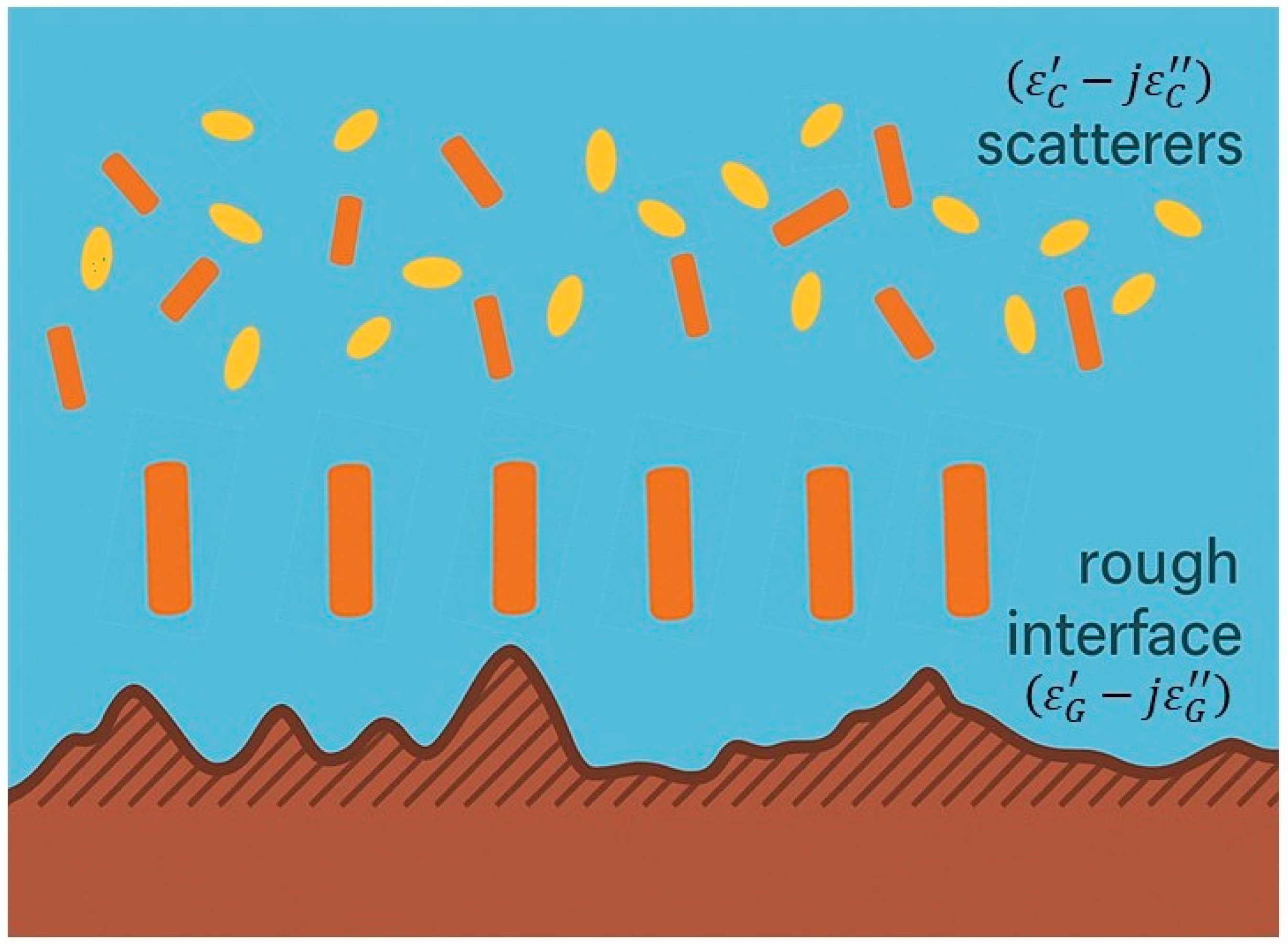

| IEEE Radar Band | Frequency Interval (GHz) | Remote Sensing Applications |
|---|---|---|
| P | 0.3–0.5 | Soil moisture estimation also under forests |
| Snow water equivalent | ||
| Forest biomass and height | ||
| L | 1–2 | Soil moisture estimation also under forests |
| Hydrology | ||
| Vegetation and crop monitoring | ||
| Vegetation biomass estimation | ||
| Snow and ice monitoring | ||
| Sea ice concentration and ice sheet volume | ||
| Ocean surface salinity and temperature | ||
| S | 2–4 | Snow and ice monitoring |
| Soil moisture estimation | ||
| Atmospheric sensing of clouds and precipitation | ||
| Sea surface temperature | ||
| Wind speed over ocean | ||
| C | 4–8 | Soil moisture estimation |
| Vegetation and crop monitoring | ||
| Snowpack analysis | ||
| Rainfall estimation | ||
| X | 8–12 | Snow and frost detection |
| Liquid water content of clouds | ||
| Atmospheric temperature profiles | ||
| Ku | 12–18 | Snow and ice properties |
| Rainfall estimation | ||
| Ocean wind speed | ||
| K | 18–26.5 | Snow thickness |
| Soil moisture estimation | ||
| Rainfall estimation | ||
| Atmospheric vertical temperature and humidity profiles | ||
| Ka | 26.5–40 | High-resolution snow, ice properties |
| Precipitation, fog and cloud properties | ||
| V | 40–75 | Atmospheric temperature profiles |
| W | 75–110 | Liquid and frozen precipitation |
| mm 1 | 110–300 | Snowfall and ice particles |
| Water vapor profiles |
| Mission Name | Space Agency/Partnership | Operating Bands (Frequency GHz) | Launch Year | Operational Status | Primary Applications |
|---|---|---|---|---|---|
| SMOS (Soil Moisture and Ocean Salinity) | European Space Agency (ESA) | L-band (1.4) | 2009 | Operational (extended) | Soil Moisture, Sea Surface Salinity |
| SMAP (Soil Moisture Active Passive) | National Aeronautics and Space Administration (NASA) | L-band (1.4) | 2015 | Operational (extended) | Soil Moisture, Freeze/Thaw State |
| Aquarius | NASA/Comisión Nacional de Actividades Espaciales (CONAE) | L-band (1.4) | 2011 | Ended 2015 | Soil Moisture, Sea Surface Salinity |
| AMSR (Advanced Microwave Scanning Radiometer) | Japan Aerospace Exploration Agency (JAXA) | C (6.9 and 7.3), X (10.7), K (18.7 and 23.8), Ka (36.5), V (50.0), W (89.0) | 2002 | Ended 2011 | Soil Moisture, Sea Surface Temperature, Polar Region Monitoring, Fire Severity, Cryosphere, Ocean Wind Speeds, Drought |
| AMSR-E (Advanced Microwave Scanning Radiometer for EOS) | JAXA/NASA | C (6.925), X (10.65), K (18.7 and 23.8), Ka (36.5), W (89.0) | 2002 | Ended 2011 | Soil Moisture, Sea Surface Temperature, Polar Region Monitoring, Fire Severity, Cryosphere, Ocean Wind Speeds, Drought |
| AMSR2 (Advanced Microwave Scanning Radiometer 2) | JAXA | C (6.925 and 7.3), X (10.7), K (18.7 and 23.8), Ka (36.5), W (89.0) | 2012 | Operational | Hurricane Intensity, Global Precipitation, Snowfall, Cryosphere, Ocean Wind Speeds, Sea Surface Temperature, Soil Moisture, Drought |
| TRMM Microwave Imager (TMI) | NASA/JAXA | X (10.7), K (19.0 and 22.0), Ka (37.0), W (85.5) | 1997 | Decommissioned 2015 | Rain Structure, Hurricane Intensity, Precipitation, Flood Forecasting, Soil Moisture, Ocean Wind Speeds, Sea Surface Temperature |
| GMI (GPM Microwave Imager) | NASA/JAXA | X (10.65), K (18.7), K (23.8), Ka (36.5), W (89.0), mm (166.0, 183 ± 3 and 183 ± 7) | 2014 | Operational (extended) | Tropical Cyclone Forecasting, Global Precipitation, Hurricane Forecasts, Ocean Wind Speeds, Sea Surface Temperature, Soil Moisture |
| SSM/I (Special Sensor Microwave/Imager) | U.S. Defense Meteorological Satellite Program (DMSP) | K (19.3), Ka (36.5 and 37.0), W (85.5) | 1987 (first unit F8) | Data archive continually updated (various units decommissioned over time) | Hurricane Intensity, Flood Detection, Soil Moisture, Ocean Wind Speeds, Sea Ice |
| SSMIS (Special Sensor Microwave Imager/Sounder) | U.S. DMSP | Ka (37.0), W (91.7) | 2003 (first unit F16) | Operational (some units still active, data flow until at least 2025/2026) | Tropical Cyclone Precipitation, Flood Detection, Snowfall, Ocean Wind Speeds, Sea Ice, Soil Moisture |
| SMMR (Scanning Multichannel Microwave Radiometer) | NASA | C (6.6), X (10.7), Ku (18.0), K (21.0), Ka (37.0) | 1978 | Ended 1987 (Nimbus 7 SMMR) | Sea Surface Temperature, Ocean Wind Speeds, Flood Detection, Soil Moisture, Sea Ice |
| Coriolis WindSat | U.S. Department of Defense (DoD) | C (6.8), X (10.7), Ku (18.7), K (23.8), Ka (37.0) | 2003 | Ended 2020 | Ocean Surface Wind Speed, NWP Improvement, Soil Moisture |
| MHS instrument (on MetOp-A) | European Organisation for the Exploitation of Meteorological Satellites (EUMETSAT)/National Oceanic and Atmospheric Administration (NOAA) | W (89), mm (157.0, 183.31 ± 1, 183.31 ± 3 and 190.311) | 2006 | Ended 2021 | Surface Temperature, Atmospheric Humidity Profiles, Precipitation Rate, Emissivity, Low Altitude Cloud Detection |
| MHS instrument (on MetOp-B) | 2012 | Operational (until 2027) | |||
| MHS instrument (on MetOp-C) | 2019 | Operational (until 2027) | |||
| MHS instrument (on NOAA-18) | 2005 | 2017 | |||
| MHS instrument (on NOAA-19) | 2009 | Operational (until 2025) | |||
| Microwave Imager (MWRI) on Fengyun-3 (FY-3) satellite series | 10.65, 18.7, 23.8, 36.5, and 89.0 (GHz), each with dual polarization (Horizontal and Vertical) | 2008 (FY-3A) 2010 (FY-3B), 2013 (FY-3C), 2017 (FY-3D), 2023 (FY-3F) | Operational Operational Operational | Soil Moisture, Snow Cover, Precipitation (rain rate), Cloud Liquid Water, Total Precipitable Water, Sea Surface Temperature, Sea Ice Concentration |
| Medium | Primary Scatterers | Dielectric Properties | Dominant Processes | Typical Frequency Range | Main Modeling Approaches | Key Challenges |
|---|---|---|---|---|---|---|
| Vegetation (Forests, Crops) | Leaves, stems, trunks, branches | Moderate permittivity (~2–15, moisture-dependent) | Attenuation, volume scattering, double-bounce (trunks) | 0.5–10 GHz (MIMICS, Tor Vergata model); L-band for SMOS/SMAP | τ–ω model, first-order RT, matrix doubling | Complex canopy geometry, orientation statistics, seasonal variation in water content |
| Snow (Seasonal Snowpacks) | Ice grains (spherical/ellipsoidal), air inclusions | Low permittivity (~1.2–1.9 dry snow; ↑ with liquid water) | Volume scattering (Mie), absorption (wet snow), ground emission transmission | 1.4–37 GHz | MEMLS, DMRT, layered RT models | Accurate grain size/density profiles, liquid water fraction, stratigraphy |
| Glacial Ice/Polar Ice Sheets | Ice crystals, air bubbles, brine pockets | Higher permittivity (~3.15 for pure ice; varies with salinity) | Volume scattering, anisotropic propagation, absorption in wet layers | 0.5–37 GHz (active & passive), radar altimetry | DMRT, anisotropic RT, layered ice models | Large-scale heterogeneity, anisotropy, coherent effects, melt layer detection |
| Mission | ubRMSE/RMSE | R | Representative Validation Notes and Source |
|---|---|---|---|
| SMAP (L-band only passive) | ≈0.04–0.05 m3/m3 (radiometer SM product) | R ≈ 0.7–0.81 | Validation vs. airborne and in situ (SMAPEx) found radiometer SM RMSE ≈ 0.05 m3/m3 and TB RMSE ≈ 3 K; global/core-site comparisons report ubRMSE ≈ 0.041 and R ≈ 0.81 [165,180] |
| SMOS (L-band) | ubRMSE ≈ 0.039–0.10 m3/m3 (product/version dependent) | R ≈ 0.4–0.80 | SMOS IC product and later reprocessing approach reach ubRMSE ≈ 0.039 with R ≈ 0.80 on core validation sites; some SMOS Level-3 regional ubRMSE up to ≈0.10 where vegetation increases [165,174] |
| AMSR-E/AMSR2 (C/X/K- bands) | bias-corrected RMSE improvements reported; regional ubRMSE often >0.05 and can exceed 0.10 | generally lower R and larger biases vs. L-band | Algorithm refinements (dynamic scattering/albedo) reduced bias-corrected RMSE by ~25–38% and increased R2 in test regions, but AMSR products still show large systematic biases over vegetated areas in several evaluations [176,179] |
| Mission | Retrieval Approach | Reported Accuracy (Typical Metric) |
|---|---|---|
| SMOS (L-band) | Iterative RTM inversion | Artic surface temperature: Median R = 0.60 (ERA5 shows R = 0.51 for sites with water fraction < 0.04) Median bias ~0.2 °C (between retrieved and in situ temperature) [213] |
| SMAP (L-band only passive) | Assimilation of TB in land surface model | The global land average RMSE versus in situ measurements of daily maximum temperature (T2mmax) is reduced by 0.04 K for LADAS compared to ADAS estimates. Regionally, the RMSE of LADAS T2mmax is improved by up to 0.3 K [214]. |
| 37 GHz simulated | Single-channel linear | Theoretical bias within 1 K for ~70% vegetated areas; precision < 2.5 K (forests) and <3.5 K (low vegetation) [202] |
| AMSR2 | Deep dynamic neural network | Mean error ≈ 1.4 K, std ≈ 1.9 K; comparison to ground stations ≈ 1.8 K accuracy [203] |
| Multifrequency simulated database | Coupled LST–SM retrieval | LST accuracy ≈ 1.63 K (simulation validation) [204] |
| AMSR-E | Two-stage parameterized algorithm | Simulated RMSE 1.45 K; cross-validation daily accuracy ≈ 3.04 K, bi-monthly ≈ 4.43 K [207] |
| AMSR2 | Physically based algorithm | Overall RMSE ≈ 5.42 K and bias ≈ 2.99 K (reported overestimation with respect to MODIS nighttime acquisitions) [205] |
| SSM/I | Pre-computed emissivity method | Bias ≈ 0.5 K vs. IR products, overall RMSE ≈ 5 K; well-controlled vegetated stations down to RMSE ≈ 2.5 K [208] |
| 6–18 GHz simulations | Iterative RTM inversion | Surface temperature accuracy ≈ 2 °C achievable (except bare soils) [206] |
| Mission | Reference Validation Data | Reported Accuracy (Typical Metric) |
|---|---|---|
| SMOS and SMAP (L-band) | Ground-based in situ plant water, NDWI, crop model | Bias: 0.02–0.09 Np over agriculture crops [236] |
| SMOS (L-Band) | Destructive VWC (Corn) | R ≈ 0.80 (between satellite VOD and VWC) [237] |
| Satellite VOD (Multi-freq) | LFMC | R ≈ 0.70 to 0.85 (VOD vs. LFMC temporal dynamics) [238] |
| AMSR-E (multifrequency) | GNSS Normalized Microwave Reflection Index (NMRI) | R2 (≈0.73) and RMSE (36.8 days) for start-of-season [235] |
| Mission | Reference Validation Data | Reported Accuracy (Typical Metric) |
|---|---|---|
| SMOS (L-band) | AGB and tree canopy height | R = 0.80–0.94 (AGB at global scale with saturation at ~360 Mg/h) [81,92,242] R = 0.87–0.90 (tree canopy height with saturation at ~30 m) [166,242] |
| AMSR (C/X/Ku-band) | AGB and tree canopy height | R lower than results with L-band for canopy height and AGB RMSD = 27.3 Mg·ha−1 [261] |
| SMOS (L-band) | GEDI and ICESat-2 RH100 and PAI | R = 0.65–0.94 (RH100 lower correlation on boreal forest, higher correlation on tropical forests) [226] R = 0.83–0.93 (PAI lower correlation on temperate forest, higher correlation on tropical forests; boreal forest not covered) [227] |
| SMOS (L-band) | Ecosystem functional properties | R2 ~ 0.93 (Africa), R2 ~ 0.87 (S. America) [249] |
| AMSR-2 (C/X/Ku-band) | fAPAR (Absorbed PAR) | R = 0.57 (short vegetation), 0.49 (broadleaf) [238] |
| AMSR-2 (C/X/Ku-band) | Leaf Area Index (LAI) | R = 0.49–0.57 [237,238] |
| AMSR (X-band) | VWC | R ≈ 0.43 (over grassland and crops) [262] |
| Mission | Reference Validation Data | Reported Accuracy (Typical Metric) |
|---|---|---|
| AMSR-2 (C/X/Ku-band) | 93 meteorological stations in Northeast China | R = 0.39 and RMSE = 26.15 cm for snow depth at native resolution; R = 0.53 and RMSE = 7.58 cm for snow depth with ML downscaling [286] |
| AMSR-2 (C/X/Ku-band) | In situ site validation with RT model LUT over Greenland Ice Sheet (during spring) | RMSE = 0.43 m, bias 0.01 m and R = 0.89 for snow depth [288] |
| SMOS (L-band) | Operation IceBridge airborne (during spring 2012) over the Arctic | RMSE = 5.5 cm (up to 35 cm snow), bias = 0.1 cm (mean difference) and R2 = 0.58 for snow thickness [284] |
| SMOS (L-band) | 43 ground stations over Quebec (Canada) | RMSE = 8.3 kg/m3, bias = 9.4 kg/m3 for Snow density [290] |
| Mission | Reference Validation Data | Reported Accuracy (Typical Metric) |
|---|---|---|
| SSM/I (37 GHz V-pol) | Global validation vs. in situ data, multi-decadal (20 years) | classification accuracy = 92.2 ± 0.8% (PM/evening) classification accuracy = 85.0 ± 0.7% (AM/moring) [231] |
| SMAP (L-band) | Global validation vs. in situ data | Global mean annual classification accuracy ~78% (descending/AM) Global mean annual classification accuracy ~90% (ascending/PM) [233] |
| SMOS (L-band) | Validation vs. in situ data over Canada | Classification accuracy = ~87.8% [234] |
| AMSR-E/AMSR-2 (C/X/Ku-band) | Validation vs. in situ data over the Tibetan Plateau | Overall accuracy = ~82.0% [235] |
| AMSR-2 + SMAP (L/C/X/Ku-band) | Comparison vs. ERA5 over the Northern Hemisphere | Mean Percent Accuracy = 92.7% [236] |
| Mission | Reference Validation Data | Reported Accuracy (Typical Metric) |
|---|---|---|
| AMSR-2 (C/X/Ku-band) | Optical flood maps (MODIS 500 m), in situ discharge, modelled inundation fractions | 65–95% agreement; mean bias ≈ −0.04 ± 0.28 (flood fraction vs. MODIS, over Bangladesh) [347] |
| SMOS (L-band) | River gauge water levels (Amazon, Orinoco, Congo); GloFAS model assimilation | R = 0.8–0.94 (water level correlation) [348,349] |
| SMAP (L-band) | In situ flood extent maps, optical water indices | Producer accuracy up to ~85–90% for flood mapping (threshold ≈ 0.04 m3/m3) [350] |
| Method | Key Characteristics | Representative Applications | Strengths | Limitations | Computational Cost | Representative Performance |
|---|---|---|---|---|---|---|
| EnKF/LETKF | Ensemble-based, flow-dependent covariance | SMAP Tb assimilation in GEOS-5; SMOS in AWRA-L [351,353,356,357] | Captures dynamic error structures; operational maturity | Gaussian assumptions; ensemble size sensitivity | Moderate–High | RMSE ≈ 0.034 m3·m−3; correlation +0.23 gain |
| EKF | Linearized update around state estimate | SMOS Tb in ECMWF H-TESSEL [358] | Computational efficiency; operational simplicity | Linearization errors in nonlinear regimes | Moderate | Improved soil moisture in data-sparse regions |
| Particle Filter/Smoother | Sequential Monte Carlo; non-Gaussian posterior | AMSR-2 Tb → Crocus SWE; RT parameter estimation [356,359,360] | Handles strong nonlinearities; joint state/parameter estimation | High computational demand; particle degeneracy | Very High | SWE bias ↓ 68%; error ↓ 5% (relative) |
| Hybrid/Dual-Cycle | Joint state-bias estimation; adaptive correction | SMAP Tb bias correction [352] | Dynamic bias adaptation; improved consistency | Complex implementation; tuning requirements | Moderate–High | Enhanced retrieval stability |
| Machine Learning–Integrated DA | ML for downscaling, operator emulation, fusion | SMAP–SMOS–AMSR-2 merged DA [361,362] | Improves resolution; accelerates forward modeling | Requires large training datasets; generalization risk | Low–Moderate | RMSE < 0.06 m3·m−3 (high-resolution SM) |
| Institution | Model | Assimilated Satellite Data | DA Method | Variables Updated | Key Performance Gains |
|---|---|---|---|---|---|
| NASA/GMAO | GEOS-5 Catchment LSM (L4_SM) [351,352,357] | SMAP, SMOS Tb | EnKF | Surface and root-zone soil moisture | Corr. +0.26; RMSE ↓ 0.008 m3·m−3 |
| ECMWF | H-TESSEL [359] | SMOS Tb | EKF | Soil moisture, surface fluxes | Improved soil moisture and surface flux realism |
| NOAA/NASA | LIS (Noah, Noah-MP, VIC) [363] | SMOS, SMAP retrievals | EnKF | Soil moisture | Hydrological forecast accuracy ↑ |
| BoM (Australia) | AWRA-L [358,364] | SMAP, SMOS Tb | EnKF | Soil moisture, water balance | Improved drought/flood prediction |
| CMA (China) | CLDAS [354] | SSM/I, AMSR-2 Tb | EnKF | Soil moisture, freeze/thaw | Enhanced regional soil moisture consistency |
| Météo-France | Crocus [356] | AMSR-2 Tb | Particle Filter | SWE | SWE bias ↓ 68%; RPE ↓ 19→14.1% |
| AWI | AWI Climate Model [365] | AMSR-2, SSM/I Tb | Coupled DA | Sea ice concentration/thickness | Improved sea ice prediction skill |
| NASA | GEOS-LADAS [363] | GEOS-5 coupled model | Weakly coupled DA | Soil moisture, T2M (Temperature at 2 m above the ground), Q2m (Specific humidity at 2 m above the ground), heat fluxes | RMSE ↓ 0.04 K (T2M var.), ↓ 0.05 g·kg−1 (Q2M var.) |
Disclaimer/Publisher’s Note: The statements, opinions and data contained in all publications are solely those of the individual author(s) and contributor(s) and not of MDPI and/or the editor(s). MDPI and/or the editor(s) disclaim responsibility for any injury to people or property resulting from any ideas, methods, instructions or products referred to in the content. |
© 2026 by the authors. Licensee MDPI, Basel, Switzerland. This article is an open access article distributed under the terms and conditions of the Creative Commons Attribution (CC BY) license.
Share and Cite
Vittucci, C.; Picchiani, M. Satellite Microwave Radiometry for the Observation of Land Surfaces: A General Review. Sensors 2026, 26, 1638. https://doi.org/10.3390/s26051638
Vittucci C, Picchiani M. Satellite Microwave Radiometry for the Observation of Land Surfaces: A General Review. Sensors. 2026; 26(5):1638. https://doi.org/10.3390/s26051638
Chicago/Turabian StyleVittucci, Cristina, and Matteo Picchiani. 2026. "Satellite Microwave Radiometry for the Observation of Land Surfaces: A General Review" Sensors 26, no. 5: 1638. https://doi.org/10.3390/s26051638
APA StyleVittucci, C., & Picchiani, M. (2026). Satellite Microwave Radiometry for the Observation of Land Surfaces: A General Review. Sensors, 26(5), 1638. https://doi.org/10.3390/s26051638