


Abstract
This study aimed to predict potentially suitable areas for Cistanche deserticola in China and to provide a scientific basis for its cultivation layout and production planning. Based on the MaxEnt algorithm and ArcGIS spatial analysis, two independent ecological niche models were constructed, one for each host–parasite system, to predict the ecologically suitable areas for C. deserticola hosted by Haloxylon ammodendron and Atriplex canescens, respectively. The suitable areas for H. ammodendron–C. deserticola were mainly distributed in central and northwestern Xinjiang, north-central Inner Mongolia, north-central Gansu and Ningxia. The highly, moderately and lowly suitable areas accounted for 20.74%, 30.63% and 30.92% of the total area of the seven provinces (Xinjiang, Inner Mongolia, Gansu, Ningxia, Qinghai, Shaanxi, and Shanxi), respectively. The suitable areas for A. canescens–C. deserticola were mainly distributed in central and western Xinjiang, west-central Inner Mongolia, central Gansu Province, north-central Ningxia, northeastern Qinghai Province and western Shaanxi Province, with highly, moderately, and lowly suitable areas accounting for 10.80%, 24.73% and 32.45% of the total area of the seven provinces, respectively. Response curve analysis revealed that annual precipitation (optimal range approximately 150–400 mm) and elevation (optimal range approximately 150–2000 m for H. ammodendron–C. deserticola and 270–1000 m for A. canescens–C. deserticola) were key factors constraining the cultivation pattern. The unimodal shape of the response curves indicated that both insufficient and excessive values of these variables reduced habitat suitability. For areas adjacent to lakes or equipped with irrigation facilities, sites with annual precipitation exceeding 150 mm should be prioritized for cultivation. It should be noted that the predicted areas represent environmental suitability derived from the correlation between occurrence records and abiotic predictors, rather than confirmed cultivation areas; field validation and consideration of biotic (host availability) and anthropogenic (land use, management) factors are required before large-scale planting. This study provides a scientific basis for the introduction and cultivation of C. deserticola in different regions and large-scale cultivation planning.
1. Introduction
Cistanche deserticola Ma (C. deserticola) is a perennial parasitic herb, which is one of the primitive plants of C. deserticola in the Chinese Pharmacopoeia (2025 Edition) [1]. C. deserticola can treat impotence, infertility and intestinal dryness constipation, and it is one of the most used and precious Chinese medicinal materials [2]. The production of C. deserticola requires the cultivation of its host plant. These host plants also have a better ability to prevent wind and fix sand, as well as saline–alkali tolerance [3]. The hosts of C. deserticola are Haloxylon ammodendron (C. A. Mey.) Bunge (H. ammodendron) or Atriplex canescens (Pursh) Nutt (A. canescens). Compared with H. ammodendron–C. deserticola, A. canescens–C. deserticola demonstrates higher yield and superior bioactive compound content, leading to its widespread introduction in recent years [4]. However, cultivated C. deserticola production is influenced by host species and the environment of the production area, showing significant yield variations across different regions, even with the same host plant [5]. At present, there is a lack of standardized evaluation methods for A. canescens–C. deserticola, which frequently leads to introduction failures and significantly increased cultivation costs. Optimal host plant selection criteria across different production regions remain to be established. Because the yield and quality of C. deserticola are strongly modulated by the match between local environmental conditions and the ecological requirements of both the host and the parasite, a spatially explicit assessment of environmental suitability, rather than simple agroclimatic zoning, can identify sites where the host–parasite complex is most likely to establish and produce high-quality medicinal material. Therefore, the scientific selection of suitable planting areas and host species, which can not only improve the planting success rate of C. deserticola but also ensure the yield and quality of its derived medicinal materials, has become an urgent scientific issue that requires immediate resolution.
The spatial distribution and prediction of food crops and cash crops have been studied and applied in cultivation and land selection, and the technology is relatively mature [6,7]. Medicinal plants occupy a distinct niche within the plant kingdom, with their biogeographical distributions exhibiting strong anthropogenic correlations. In recent years, relevant techniques have also been applied to the prediction of the ecological distribution of traditional Chinese medicine [8]. Species distribution models (SDMs)—a general class of methods including CLIMEX, GARP, and MaxEnt—were often used to predict species distribution, and the output results of these models could be combined with ArcGIS software for visual analysis of results [9,10]. Among them, MaxEnt has been widely applied to medicinal plant distribution prediction [11,12,13,14] and generally performs well when provided with adequate occurrence records and ecologically relevant predictors; however, its accuracy depends on sample quality, predictor selection, background definition, and the specific modeling task, and no single algorithm is universally optimal. Li et al. used the MaxEnt model to predict the change in the suitable area of Gymnadenia orchidis in the Tibetan Plateau under the condition of climate change [15]. Zhang et al. conducted a comparative analysis of multiple models and demonstrated that the MaxEnt model exhibited optimal performance [16]. The MaxEnt model demonstrates strong computational performance in predicting plant ecoregions under climate change scenarios, as well as identifying potential ecoregions in the current period. Li et al. explored the patterns of climate change and speculated the current potential distribution areas and future suitable areas of three Coptis herbs in China [17].
Unlike most model species, C. deserticola is an obligate parasite whose realized niche is jointly determined by its own abiotic requirements and the distribution of its hosts. Comparing two host–parasite systems within the same SDM framework can disentangle how host identity shifts the environmental envelope of the parasite, a question that cannot be answered by conventional agroclimatic zoning alone. The central scientific question of this study is as follows: how does host identity (H. ammodendron vs. A. canescens) reshape the environmental suitability envelope and potential cultivation range of C. deserticola, and which abiotic factors drive the divergence? Answering this question requires not only mapping suitable areas but also quantifying the relative contribution and response shape of each environmental predictor for each host–parasite system. In recent years, numerous studies have investigated the selection of C. deserticola cultivation and ecologically suitable areas. For example, Shao et al. [18] and He et al. [19] explored the geographical distribution of C. deserticola-parasitizing H. ammodendron under climate change using the MaxEnt model. However, most existing studies lack field-based empirical validation of model prediction accuracy. Furthermore, no previous research has conducted suitability zoning for C. deserticola-parasitizing A. canescens, and few comparative analyses have been performed for C. deserticola growing on two different host plants.
Against this research background, this study clearly defines the following four core objectives: (1) to construct MaxEnt ecological suitability models for two parasitic systems (H. ammodendron–C. deserticola and A. canescens–C. deserticola) based on species occurrence records and multi-dimensional environmental variables; (2) to identify the key climatic, topographic, and soil factors restricting the ecological suitability of the two host–parasite combinations; (3) to visualize and compare the potential suitable cultivation areas across China by integrating ArcGIS and MaxEnt analysis; and (4) to delineate priority planting regions and identify current cultivation gaps, so as to provide practical support for host selection, regional introduction, and industrial layout optimization for C. deserticola. Overall, this study aims to clarify the optimal planting ranges and critical environmental thresholds for C. deserticola under different host conditions. The findings provide a scientific basis for the rational layout, introduction, large-scale cultivation, and resource conservation of C. deserticola, while offering a valuable reference for the regional planting planning of other multi-host medicinal and economic crops.
2. Materials and Methods
2.1. Investigation and Records of Species Distribution Information
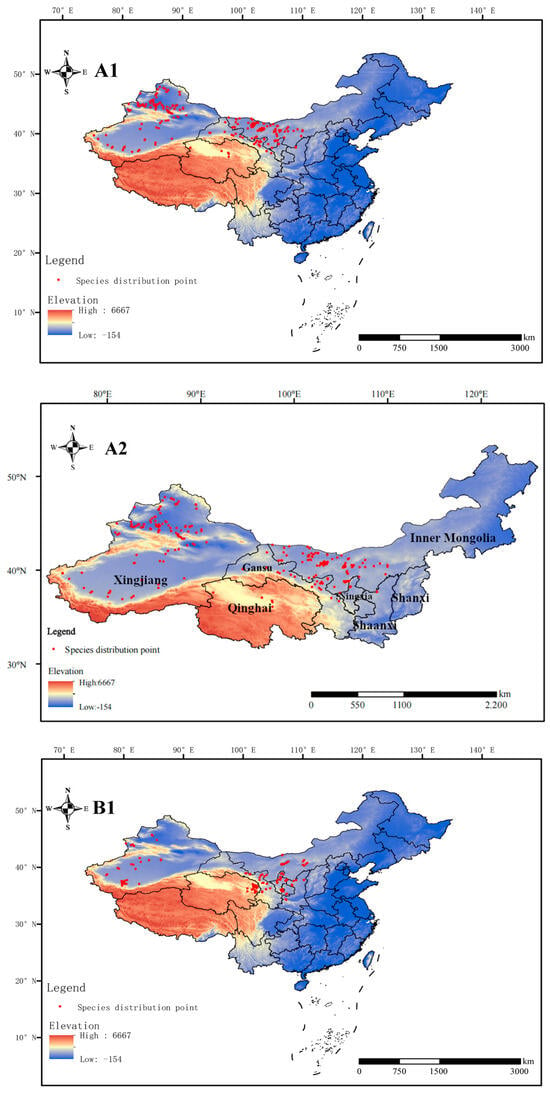
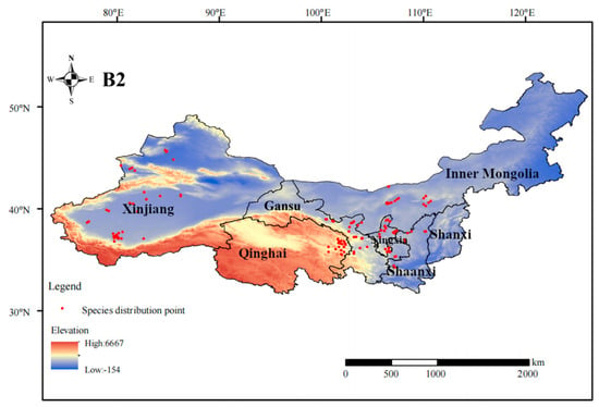
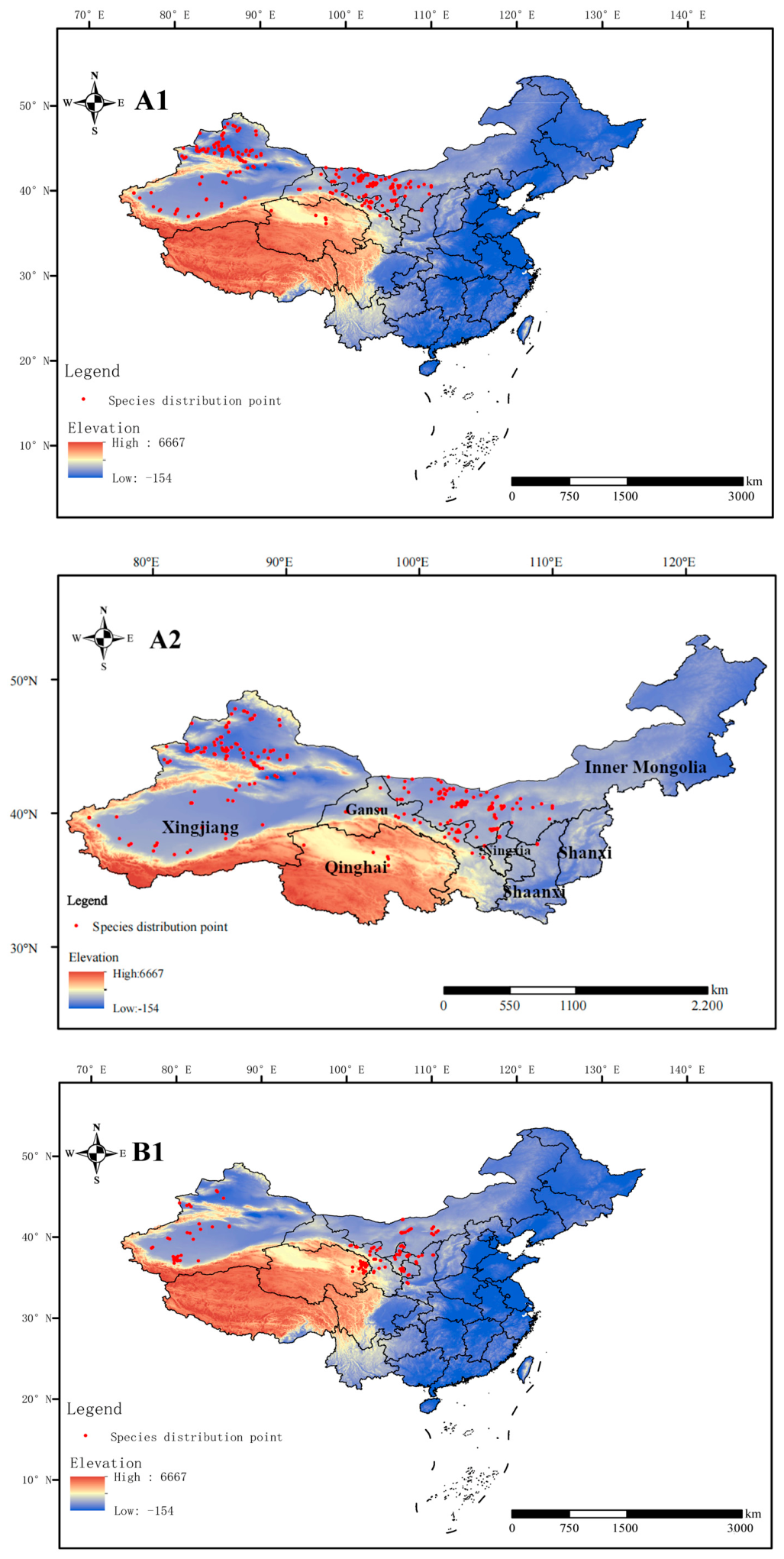
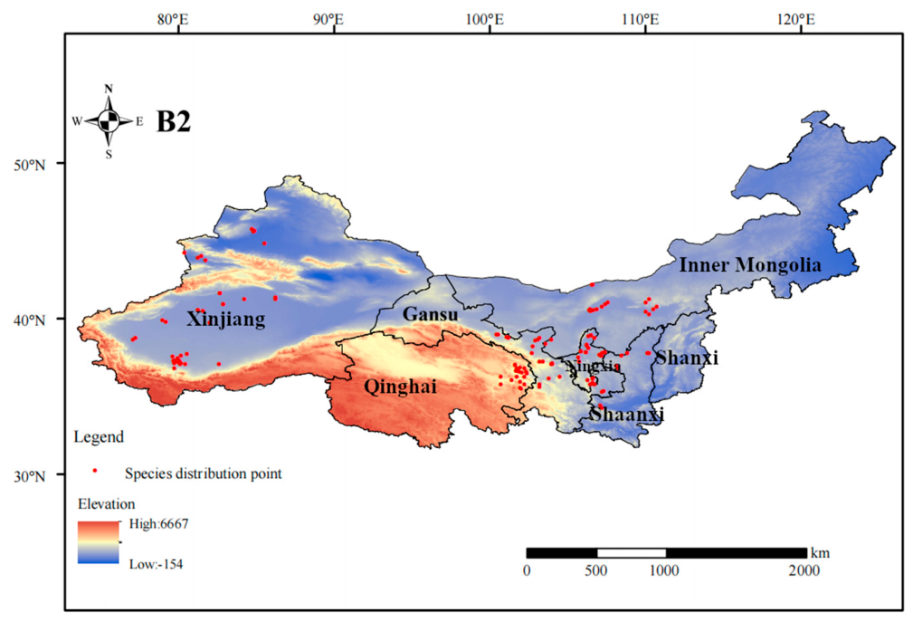
The distribution data of H. ammodendron–C. deserticola mainly came from field investigation records, literature review and Internet information retrieval [20,21,22,23,24,25]. Among them, the Internet information retrieval websites mainly included the Global Biodiversity Information Facility (GBIF occurrence download. Available online: https://www.gbif.org, accessed on 29 August 2026) and the National Plant Specimen Resource Center (CVH occurrence download. Available online: https://www.cvh.ac.cn, accessed on 29 August 2026). In order to ensure the accuracy of species distribution information, only the information with clear latitude and longitude data was selected in GBIF. Only location information down to the county administrative level was selected in the CVH. After screening, a total of 282 records of H. ammodendron–C. deserticola were available for analysis (Figure 1(A1,A2) and Figure 2). The information was saved in CSV format for the subsequent establishment of mathematical models.
Figure 1.
Distribution of C. deserticola ((A1) (China)-(A2) (Partial): H. ammodendron–C. deserticola; (B1) (China)-(B2) (Partial): A. canescens–C. deserticola. Map review number: GS (2024) 0650).
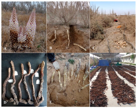
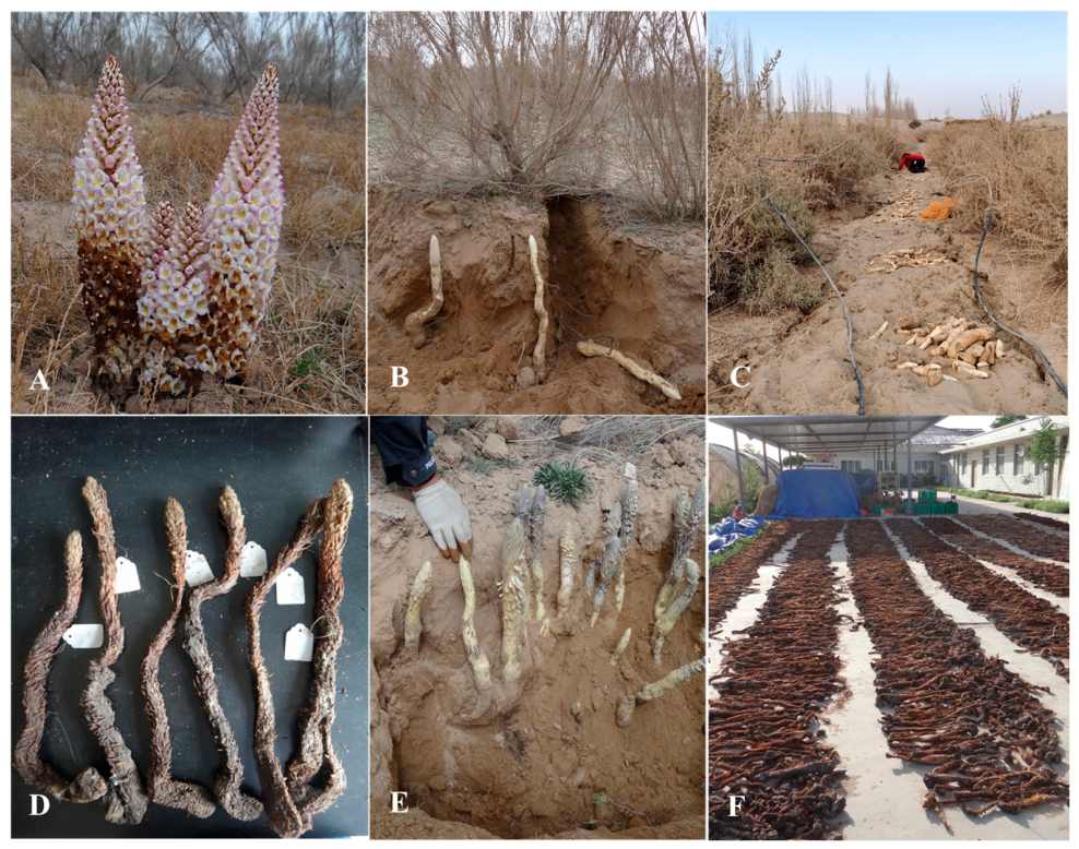
Figure 2.
Pictures of C. deserticola specimens and samples ((A): planted on the soil surface; (B,C,E): buried; (D): sun dried; (F): freshly harvested).
The distribution data of A. canescens–C. deserticola mainly came from field investigation records, literature review and Internet information retrieval. Among them, the Internet information retrieval websites mainly included the Global Biodiversity Information Facility (GBIF occurrence download. Available online: https://www.gbif.org, accessed on 29 August 2026) and the National Plant Specimen Resource Center (CVH occurrence download. Available online: https://www.cvh.ac.cn, accessed on 29 August 2026). In order to ensure the accuracy of species distribution information, only the information with clear latitude and longitude data was selected in GBIF. Only location information down to the county administrative level was selected in the CVH. After screening, a total of 137 records of A. canescens–C. deserticola were available for analysis (Figure 1(B1,B2)). The information was saved in CSV format for the subsequent establishment of mathematical models.
2.2. Collecting Environmental Factor Data
Considering the types of environmental factors, three types of climate factors, terrain factors and soil factors were selected for mathematical model analysis. Among them, 19 climate factors and terrain factors were taken from WorldClim (WorldClim occurrence download. Available online: https://www.worldclim.org, accessed on 29 August 2026). The data had a spatial resolution of 2.5 arcminutes (approximately 4.5 km at the equator). Soil factors were derived from HWSD (Harmonized World Soil Database, https://iiasa.ac.at, accessed on 29 August 2026), an elevation dataset jointly developed by the Food and Agriculture Organization of the United Nations and the International Soil Reference and Information Centre. These variables capture both the annual averages and the seasonal extremes of temperature and precipitation, which are closely linked to the dormancy, germination, and parasitic establishment of C. deserticola. The three topographic factors—elevation (elev), slope (slop), and aspect (aspe)—were extracted from the SRTM digital elevation model and reflect the microclimatic heterogeneity created by relief, including solar radiation receipt, water drainage, and cold-air pooling. The 36 soil factors retrieved from HWSD encompass physical properties (sand/silt/clay fractions, bulk density, available water capacity, coarse fragments, drainage), chemical properties (pH, organic carbon, CEC, base saturation, CaCO3, gypsum), taxonomic/categorical attributes (USDA texture class, soil order, FAO-74/85 classification, hydrologic group), and taxonomic classification. These soil attributes govern water-holding capacity, aeration, and nutrient availability, all of which influence host root development and subsequent haustorial connection by C. deserticola. A note on predictor scope follows: The present model includes only abiotic predictors (climate, topography, soil). Biotic interactions, most critically the distribution and abundance of host plants, and anthropogenic factors (land use, grazing intensity, cultivation history, irrigation infrastructure) are not included as predictors. This choice was made because consistent, spatially explicit layers for host plant biomass and anthropogenic variables were not available at the study scale.
2.3. Layer Preprocessing
Following the BAM (Biotic–Abiotic–Movement) framework, the background region was defined as the seven west-central provinces and autonomous regions that encompass the known and potential cultivation range. This extent was chosen because it represents the area that the species could plausibly reach via natural dispersal or human-mediated introduction, and it avoids including environmentally irrelevant regions that would inflate AUC through geographical contrast. Mask extraction was carried out on the downloaded environmental factor data to obtain the layer data for the territory of China. The topographic map layers and soil factors were split and data extracted to obtain 3 terrain factors (elevation, slope and slope direction) and 36 soil factors, which were converted into ASC format for the establishment of subsequent mathematical models. All environmental data were put into MaxEnt v3.4.4 software for pilot run, and factors with contribution rate greater than 0 were selected to participate in model construction [26]. This method helped to reduce the error caused by overfitting.
2.4. Mathematical Model Construction and Verification
Steps included the following: Load the species distribution records (in CSV format) into the Samples module of MaxEnt software. Import the environmental factor files (in ASC format) through the “Environmental Layers” module. The continuous variable was selected as “continuous” and the non-continuous variable was selected as “categorical”. The selection of output files included drawing response curves, prediction graphs, jackknife methods to replace important values and contribution rates. In detail, the MaxEnt model estimates the probability distribution of maximum entropy over the study area, subject to constraints imposed by the environmental conditions at species occurrence localities. Model verification was performed using a replicated cross-validation scheme: 75% of occurrence records were randomly assigned to the training set and 25% to the test set, the mean and standard deviation of the area under the receiver operating characteristic curve (AUC) across the 10 replicates were reported, and the final result was averaged [27]. In addition to AUC, the true skill statistic (TSS) was calculated as TSS = sensitivity + specificity − 1, with TSS > 0.7 indicating good model performance. The omission rate at the 10% training presence threshold was also monitored to assess overfitting [28].
2.5. Ecological Suitability Zoning
The predicted ecological suitability of C. deserticola was classified by the ArcGIS reclassification tool. It should be noted that these classes represent model-predicted environmental suitability rather than confirmed ecologically suitable areas. According to the literature investigation and field investigation, the suitability values were divided into four levels: non-suitable areas (0–0.1), lowly ecologically suitable areas (0.1–0.2), moderately ecologically suitable areas (0.2–0.4) and highly ecologically suitable areas (0.4–1) [29].
2.6. Multicollinearity Analysis and Data Processing
MaxEnt v3.4.4 was used for ecological suitability prediction analysis. ArcGIS v10.4.1 was used for layer preprocessing and graphics rendering. All statistical analyses were implemented in IBM SPSS v25 and R v4.2.3. Pearson correlation coefficients were computed using the environmental values extracted at the 282 and 137 occurrence localities, respectively; each occurrence record was treated as one observation. The significance of each coefficient was assessed with a two-tailed t-test (p < 0.05). To assess multicollinearity among environmental variables, Spearman’s rank correlation coefficients were calculated for the C. deserticola populations separately. Variables with |r| ≥ 0.8 were considered highly correlated, and one collinear pair was removed from subsequent MaxEnt modeling based on its biological relevance to C. deserticola habitat. All eliminated variables were determined according to the threshold of |r| ≥ 0.8 while retaining variables with stronger ecological significance; 18 variables were selected for H. ammodendron and 19 for A. canescens. For the H. ammodendron–C. deserticola model, six highly collinear variables (bio-5, bio-10, bio-13, bio-18, bio-19, and t_usda_tex_class) were removed. For the A. canescens–C. deserticola model, seven highly collinear variables (bio-1, bio-8, bio-9, bio-10, bio-14, bio-15, and bio-17) were excluded. Correlation heatmaps were generated to visualize pairwise correlations among the environmental factors. The correlation structures between the two populations were compared using differential heatmaps.
3. Results
3.1. High Reliability of the Mathematical Model
The prediction accuracy of the MaxEnt model was usually judged by the area under the ROC curve (AUC). The value of AUC ranged from 0 to 1. When 0 < AUC < 0.5, the model prediction failed. When 0.6 < AUC < 0.7, it indicated that the prediction effect of the model needed to be optimized. When 0.7 < AUC < 0.8, the prediction effect of the model was average. When 0.8 < AUC < 0.9, it indicated that the model had a good prediction effect. When AUC > 0.9, it indicated that the prediction effect of the model was excellent. In the present period, the maximum entropy model operation was carried out for C. deserticola, which was hosted by H. ammodendron and A. canescens. Figure S1A showed that the AUC value and standard deviation of the mathematical model of H. ammodendron–C. deserticola were 0.945 and 0.007. Figure S1B showed that the AUC value and standard deviation of the mathematical model of A. canescens–C. deserticola were 0.930 and 0.02. This showed that the results of the two mathematical models were excellent and could be analyzed in the next step. Because background points were restricted to the seven-province accessible area rather than the entire territory of China, the AUC values reflect the model’s ability to distinguish occurrence environments from the ecologically relevant background. Nevertheless, AUC alone does not confirm ecological validity; the response curves and jackknife results should be interpreted jointly.
3.2. Model Construction Based on Environmental Factor Screening
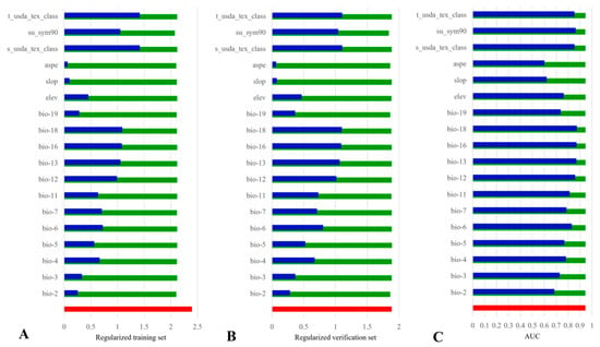
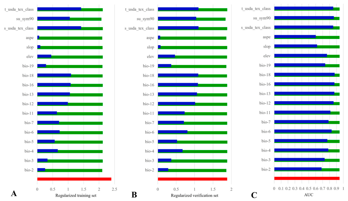
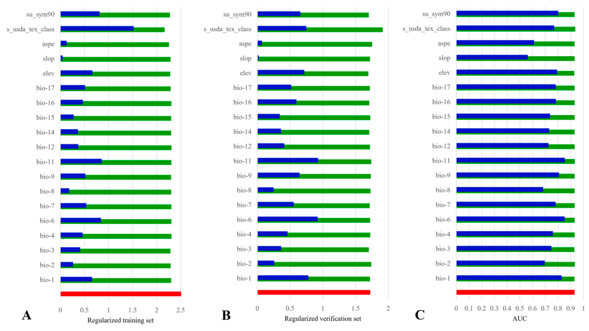
Model construction for H. ammodendron–C. deserticola was as follows: A total of 58 environmental factors (19 climate factors, 3 topographic factors, and 36 soil factors) were used for preliminary modeling. After mathematical model operation and environmental factor screening, 18 environmental factors were finally selected for mathematical model construction, including 12 climate factors, 3 terrain factors and 3 soil factors. MaxEnt’s calculation results showed that bio-18 contributed the most (40.1%) to the modeling process, which was followed by su_sym90 (14.1%), elev (13.7%), s_usda_tex_class (7.9%), bio-2 (4.5%), bio-12 (3.0%), t_usda_tex_class (3.0%), bio-7 (2.4%), bio-3 (2.1%), bio-16 (1.7%), bio-5 (1.7%), bio-6 (1.6%), bio-4 (1.0%), bio-13 (1.0%), bio-11 (0.8%), aspe (0.8%), bio-19 (0.7%), slop (0.2%). The important value of replacement is shown in Table 1. Figure 3 analyzes the gain values of the training set, verification set and AUC based on the jackknife method. The change trend of the gain value of each modeling factor was basically consistent with the contribution rate trend (Table 1).
Table 1.
Permutation importance of environmental factor replacement for the two models.
Figure 3.
Jackknife diagrams of 18 environmental factors affecting the distribution of H. ammodendron–C. deserticola ((A): regularized training set jackknife diagram; (B): regularization verification set jackknife diagram; (C): AUC jackknife diagram). Full definitions are provided in Supplementary Material. When only one factor was used for modeling, the gain values were blue strips. When modeling with variables other than this factor, the gain value was a green strip. When modeling with all factors, the gain value was a red strip.
Model construction for A. canescens–C. deserticola was as follows: After mathematical model operation and environmental factor screening, 19 environmental factors were finally selected for mathematical model construction, including 14 climate factors, 3 terrain factors and 2 soil factors. MaxEnt’s calculation results showed that elev contributed the most in the modeling process (20.4%), which was followed by s_usda_tex_class (15.1%), su_sym90 (14.7%), bio-14 (11.0%), bio-11 (8.9%), bio-7 (8.5%), bio-17 (4.6%) and bio-2 (3.4%), aspe (2.9%), bio-9 (2.7%), bio-15 (2.0%), bio-3 (1.9%), bio-12 (1.4%), slop (1.1%), bio-6 (0.7%), bio-1 (0.2%), bio-4 (0.2%), bio-8 (0.2%), bio-16 (0.2%). The important value of replacement is shown in Table 1. The change trend of the gain value of each modeling factor was basically consistent with the contribution rate trend (Figure 4). The meanings represented by each environmental factor are shown in Table S1. The results showed that precipitation and elevation were important factors affecting the two species of host C. deserticola, and the soil type was closely related to the water retention capacity of the soil. Therefore, soil type was also a key environmental factor affecting the growth and development of C. deserticola. However, compared with A. canescens–C. deserticola, H. ammodendron–C. deserticola was more demanding on the highest temperature in the warmest month, precipitation in the wettest month, precipitation in the warmest quarter and precipitation in the coldest quarter. This was also an important difficulty, limiting its artificial planting and cultivation.
Figure 4.
Jackknife diagrams of 19 environmental factors affecting the distribution of A. canescens–C. deserticola ((A): regularized training set jackknife diagram; (B): regularization verification set jackknife diagram; (C): AUC jackknife diagram). When only one factor was used for modeling, the gain values were blue strips. When modeling with variables other than this factor, the gain value was a green strip. When modeling with all factors, the gain value was a red strip.
3.3. Predicting Contemporary Ecologically Suitable Areas Using MaxEnt Modeling
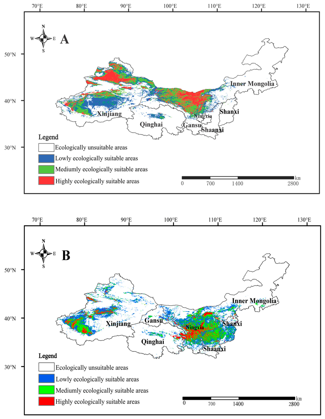
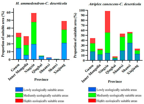
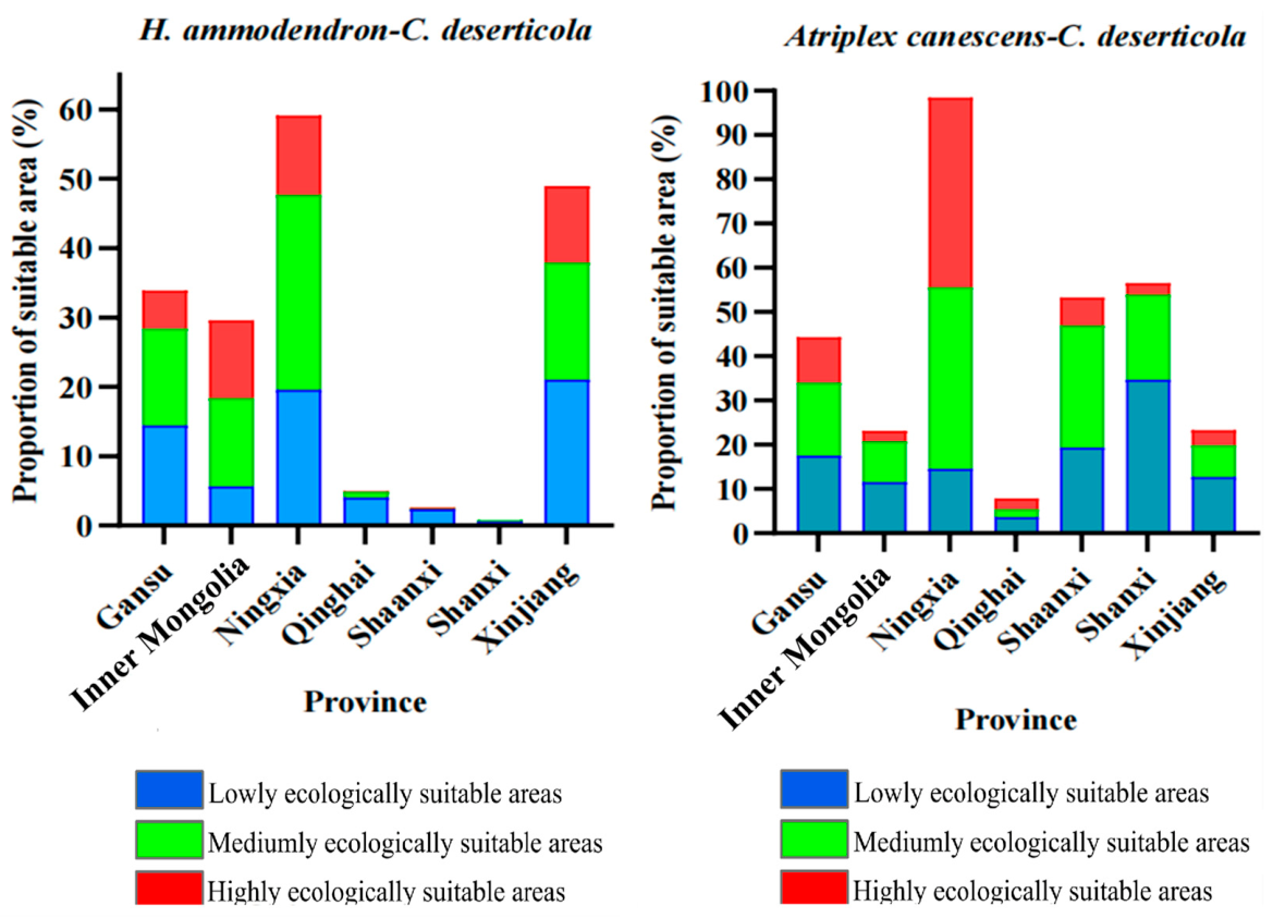
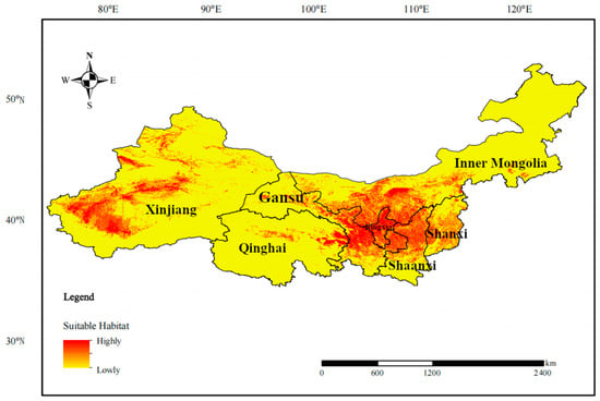
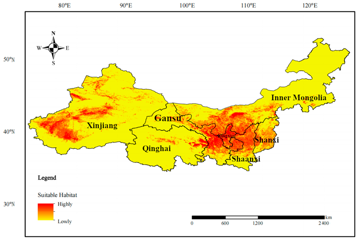
Predicting potential ecologically suitable areas for H. ammodendron–C. deserticola included the following: The results showed that the potential ecologically suitable areas of C. deserticola were distributed in northwestern China. The highly ecologically suitable areas of H. ammodendron–C. deserticola were distributed in central and northwestern Xinjiang (northern Tianshan Mountains, Tarim Basin and Turpan Basin), north-central Inner Mongolia (Alashan region), north-central Gansu Province and north-central Ningxia Autonomous Region (northwest of Loess Plateau) (Figure 5A). Its moderately ecologically suitable areas were distributed in most parts of Xinjiang (south of Altai Mountains), central and western Inner Mongolia (around Alxa), northern Gansu Province and central and northern Ningxia Autonomous Region (Qilian Mountains). The lowly ecologically suitable areas were distributed in the southern part of Xinjiang (Kunlun Mountains region), the northern part of Gansu Province, the northern part of Shaanxi Province, the central part of Qinghai Province and the central part of Ningxia Autonomous Region (Qilian Mountains region). The potential distribution of suitable areas at each level is shown in Table S2. In general, the total ecologically suitable areas of H. ammodendron–C. deserticola accounted for 82.29% of the seven provinces, indicating that the ecologically suitable areas were good. Among them, the highly, moderately and lowly suitable areas accounted for 20.74%, 30.63% and 30.92%, respectively. Figure 6 shows the distribution area ratio of H. ammodendron–C. deserticola in seven provinces. Among them, Ningxia and Xinjiang had the greatest potential for suitable life, and more than half of the areas could plant H. ammodedron–C. deserticola. But suitable areas in Shanxi Province were the most limited. Although administrative boundaries are not ecologically meaningful per se, the provincial-level area breakdown is provided because cultivation planning, land use permitting, and agricultural extension services in China are administered at the provincial level. This disaggregation, therefore, translates model predictions into a format directly usable by regional agricultural authorities.
Figure 5.
Predicted ecological suitability of C. deserticola ((A): H. ammodendron–C. deserticola; (B): A. canescens–C. deserticola). Suitability classes: ecologically unsuitable areas (0–0.1), lowly ecologically suitable areas (0.1–0.2), moderately ecologically suitable areas (0.2–0.4), highly ecologically suitable areas (0.4–1). Map review number: GS (2024) 0650).
Figure 6.
Area proportion of the suitable area of the two C. deserticola samples.
Predicting potential ecologically suitable areas for A. canescens–C. deserticola included the following: The highly ecologically suitable areas of A. canescens–C. deserticola were distributed in central and western Xinjiang (Junger Basin area connected with Tianshan Mountains and Kunlun Mountains area), central and western Inner Mongolia (north of Yinshan Mountains area), central Gansu Province and central and northern Ningxia Autonomous Region (northwest of Loess Plateau), northeastern Qinghai Province (Xining City, Haidong City, central Hainan Tibetan Autonomous Prefecture), Shaanxi Province (Weinan City north) (Figure 5B). Its moderately ecologically suitable areas were distributed in western Xinjiang (Qaidam Basin), southwestern Inner Mongolia, northeastern Qinghai Province and south-central Gansu Province (Helan Mountains), central Ningxia Autonomous region and northern Shaanxi Province (most of the Loess Plateau), central Shanxi Province (Taihang Mountains). Low-suitability areas were distributed in western Xinjiang (Tarim Basin), central Inner Mongolia (Ordos and its northern regions), northern Gansu Province (southern Hexi Corridor), southern Ningxia Autonomous Region, central Shaanxi Province and north-central Qinghai Province (Loess Plateau region), and central and eastern Shanxi Province (Haihe River basin region). The potential distribution locations of suitable areas at all levels are shown in Table S3.
Overall, the total ecologically suitable areas of A. canescens–C. deserticola accounted for 85.69% of the seven provinces, indicating that the ecologically suitable areas in this area were good. Among them, the highly, moderately and lowly ecologically suitable areas accounted for 10.80%, 24.73% and 32.45%, respectively. Figure 6 shows the distribution area ratio of A. canescens–C. deserticola in seven provinces. Among them, Ningxia, Shaanxi and Gansu Provinces had the greatest potential for living. In Shanxi Province, although the proportion of suitable areas was more than 50%, the proportion of highly and moderately suitable areas was relatively small, so the suitable areas also had great limitations.
3.4. Correlation Analysis of Environmental Factors of H. ammodendron–C. deserticola and A. canescens–C. deserticola
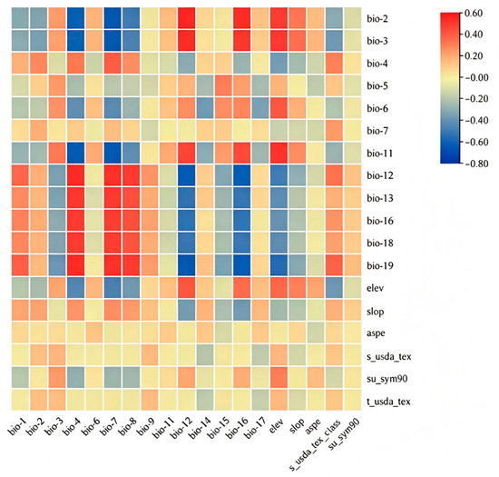
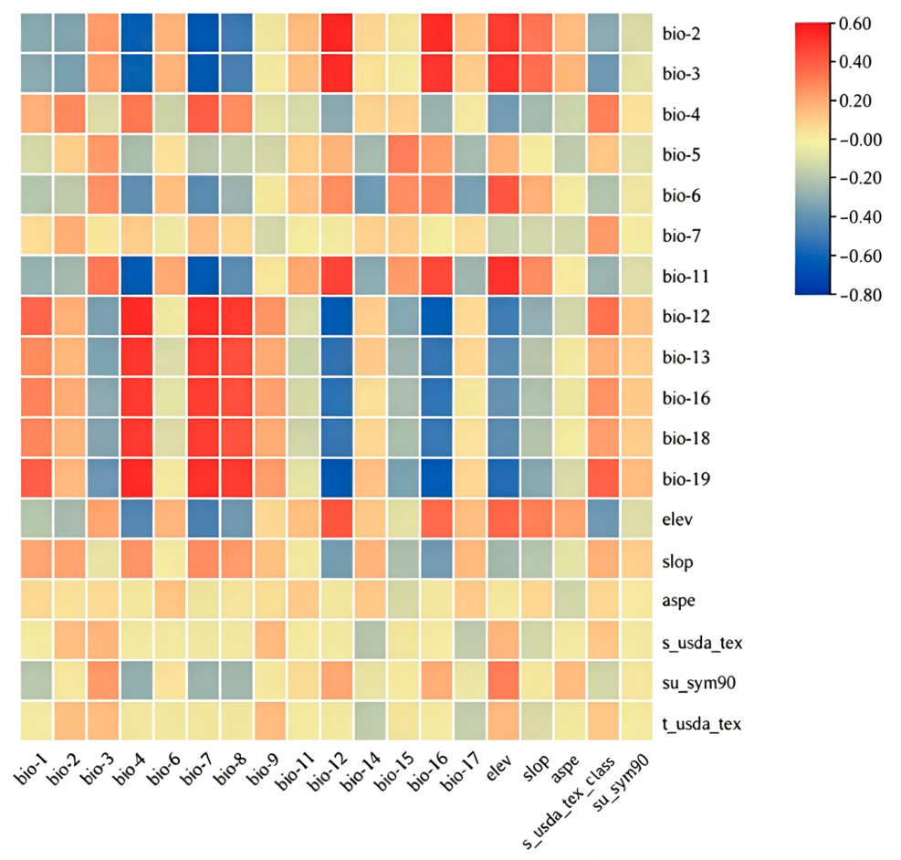
The correlation analysis results of environmental factors in the growth area of the two C. deserticola samples are shown in Figure 7. The deeper the red or blue color, the stronger the positive or negative correlation. The results showed that A. canescens–C. deserticola seasonal variation in temperature, the range of annual average temperature and the average temperature in the wettest quarter were significantly positively correlated with annual precipitation, precipitation in the wettest month, precipitation in the wettest quarter, precipitation in the warmest quarter and precipitation in the coldest quarter, and significantly negatively correlated with the monthly mean value and isotherm of diurnal temperature difference. The average annual precipitation and the precipitation in the wettest quarter of A. canescens–C. deserticola were negatively correlated with the annual precipitation, the precipitation in the wettest month, the precipitation in the wettest quarter, the precipitation in the warmest quarter and the precipitation in the coldest quarter, and were positively correlated with the monthly mean and isotherm of diurnal temperature difference. The altitude of A. canescens–C. deserticola was positively correlated with the average temperature of the coldest quarter and negatively correlated with the precipitation of the coldest quarter. In conclusion, the correlation between precipitation factor and temperature factor was obvious. It should be noted that Pearson correlation captures linear associations and does not describe the unimodal ecological response curves that are characteristic of species–environment relationships; accordingly, the correlation heatmap is used here solely to identify collinearity and covariation among predictors, not to infer ecological optima.
Figure 7.
Correlation heatmaps of environmental factors of two C. deserticola samples (horizontal coordinate: environmental factors of A. canescens–C. deserticola; ordinate: environmental factors of H. ammodendron–C. deserticola).
3.5. Vacancy Analysis of C. deserticola Suitable Cultivation Area
Vacancy analysis of C. deserticola suitable cultivation area included the following: According to the predicted results, the most suitable growth area for H. ammodendron–C. deserticola was mainly distributed in northern Xinjiang and central Inner Mongolia, which was also consistent with the actual distribution. An analysis of the environment in its suitable growing areas found that the precipitation in the warmest quarter, the average temperature in the coldest quarter, the altitude, the monthly mean temperature difference between day and night, and the average annual precipitation were 5.05–131.05 mm, −32.97–6.22 °C, −152.58–4663.94 m, 3.81–16.22 °C, and 26.51–346.98 mm, respectively. When the precipitation in the warmest quarter, the average temperature in the coldest quarter, the altitude, the monthly mean temperature difference between day and night and the average annual precipitation were 5.05 mm, −8.62 °C, −152.58 m, 3.81 °C and 188.72 mm, respectively, the optimum values of H. ammodendron–C. deserticola were 0.83, 0.66, 0.71, 0.68, 0.68, respectively.
The prediction results of the suitable growing areas of A. canescens–C. deserticola showed that the most suitable growing areas were mainly distributed in western Xinjiang, central Inner Mongolia, most of Ningxia, northern Gansu Province and eastern Qinghai Province. It was found that the altitude, driest monthly precipitation, coldest quarterly mean temperature and average annual temperature ranged from 273.30 to 6839.00 m, 5.06 to 54.39 mm, −14.43 to 14.42 °C and 23.19 to 66.80 °C, respectively. When the maximum altitude, driest monthly precipitation, coldest quarterly mean temperature and average annual temperature were 1026.49 m, 5.06 mm, −0.09 °C and 62.11 °C, respectively, the maximum health values of A. canescens–C. deserticola were 0.89, 0.83, 0.93 and 0.89, respectively.
3.6. Prediction of Potential Distribution for C. deserticola
Although all the subjects in this study were C. deserticola, there were some differences in its ecological distribution due to different hosts. Therefore, in order to show the ecological distribution of C. deserticola in a more comprehensive and systematic way, Figure 5A,B were superimposed to obtain Figure 8. C. deserticola was most suitable for cultivation in Tarim Basin, Ili River basin, Xilinhot area, Yellow River basin, Ningxia Autonomous Region, Yellow River basin of Gansu Province, Weihe River basin of Shaanxi Province and Wudinghe River basin. The average annual precipitation in these areas was between 200 and 400 mm, and they were close to the river, which could meet the growth requirements of H. ammodendron and A. canescens but not make the environment too humid for the growth of C. deserticola. Figure 8 represents the suitable growth areas of C. deserticola with both host species, and it could be found that the total range of the suitable areas was different from the simple addition of H. ammodendron–C. deserticola and A. canescens–C. deserticola but somewhat reduced. For example, H. ammodendron–C. deserticola had the potential to be planted in a large area in the Junger Basin, but the suitability values of A. canescens–C. deserticola and the general C. deserticola were not high in this area. The ecological distribution map of C. deserticola and its two host species showed that the area of highly suitable area increased in southern Ningxia, southeast Gansu, northern Shaanxi and central Shanxi Provinces.
Figure 8.
Ecological spatial distribution of C. deserticola. Map review number: GS (2024) 0650.
4. Discussion
4.1. Differential Environmental Responses in Two C. deserticola Species
H. ammodendron–C. deserticola and A. canescens–C. deserticola exhibited significant differences in ecologically suitable areas across seven provinces. The former may be because of the Taihang and Qinling Mountains in the southeastern Ningxia Autonomous Region, which block the precipitation of the southeast monsoon climate, so that its annual precipitation was 200 to 400 mm [30]. Xinjiang is located in mainland Asia and blocked by the Tianshan and the Qilian Mountains. The annual precipitation is less than 200 mm, which is suitable for the precipitation requirements of H. ammodendron–C. deserticola. However, there are no extended mountains in the southeastern Shanxi Province, and the southeast monsoon wind climate and ocean currents could carry rainfall clouds to this area, so the cold and warm air currents could converge to form more precipitation. The annual precipitation is 400–800 mm, far exceeding the precipitation suitable for the growth of H. ammodendron–C. deserticola. The latter may be because A. canescens–C. deserticola had a higher demand for precipitation and a wider range of adaptation to water. Therefore, some areas suitable for the growth of H. ammodendron–C. deserticola could also grow A. canescens–C. deserticola. In addition, the annual precipitation in the area of about 400 mm also had the distribution of A. canescens–C. deserticola.
The effect of precipitation on the growth and development of C. deserticola is much stronger than other factors, which is the key limiting factor of C. deserticola. The correlation between the same environmental factors of the two C. deserticola samples was not obvious, which also proved that the suitable area of C. deserticola was greatly affected by the growth habits of the host, and there were significant differences in their growth environmental conditions. In actual planting production, we should pay attention to the regional temperature and precipitation, according to local conditions and reasonable planning.
4.2. Distribution Divergence of Two C. deserticola Species
According to the field investigation and literature research about H. ammodendron–C. deserticola, Karamay District of Xinjiang and Alashan League of Inner Mongolia are the main planting areas of H. ammodendron–C. deserticola. These areas are located in the desert edge of the basin or the plateau area, with elevation between 500 and 1500 m and annual precipitation below 250 mm. The soil texture is mostly gray-brown desert soil, desert wind sand soil, brown calcium soil, etc. The climate is arid, the surface soil water evaporation is large, and the temperature difference between day and night in the region is large, which are suitable for the growth of H. ammodendron–C. deserticola and conducive to its parasitism. The results of comparison of prediction maps showed that although there are no large-scale planting areas in Wensu County, Wushi County, Baiyang City and Xinxing City in Xinjiang, Siwangzi County and Wuyuan County in Inner Mongolia, Jingtai County in Gansu Province, etc., the environmental conditions were in line with the best growing conditions of H. ammodendron–C. deserticola, and they were potential planting areas.
According to the field investigation and literature research about A. canescens–C. deserticola by the members of the research team, pilot planting areas of A. canescens–C. deserticola were found in Kashi, Hetan, Kekedara and Karamay of Weili County, Bayannaoer of Inner Mongolia, Yinchuan, Wuzhong and Zhongwei of Ningxia, Wuwei and Baiyin of Gansu Province and Hainan Tibetan Autonomous Prefecture of Qinghai Province. These areas are located around lakes, between mountains and plains and at the edge of basins. Their annual precipitation is less than 400 mm, the temperature difference between day and night is large, and the soil texture is mostly a saline–alkali arid zone, dominated by brown desert and desert wind sand. The growth conditions of A. canescens–C. deserticola are more extensive than those of H. ammodendron–C. deserticola, and the range suitable for growth is also wider. Therefore, the range of the suitable area of A. canescens–C. deserticola is mainly restricted by the parasitic conditions of C. deserticola rather than A. canescens’s ecologically suitable area restrictions. The results of comparative prediction maps showed that although there are no large-scale planting areas in Wusu City, Changji City, Tiemenguan City, Keping County and Yutian County of Xinjiang, Sunite Right Banner, Xinghe County and Dalat Banner of Inner Mongolia, Lanzhou City and Qingyang City of Gansu Province, Yan’an City of Shanxi Province, Linfen City of Shanxi Province, etc., the environmental conditions are in line with the optimal growth conditions of A. canescens–C. deserticola, which is a potential planting area.
By integrating the distribution patterns of two C. deserticola species, this study developed predictive distribution models, revealing significant spatial variations in the Junggar Basin region. This may be because the Tianshan Mountains meander to the southern Jungar Basin. Although the temperate monsoon climate from the southeast can bring precipitation and wet monsoons, it is blocked by the Tianshan Mountains, and the Altai Mountains are located in the north of the basin, making the basin an isolated environment; the temperate continental climate means it is difficult for cold and hot air convection to form precipitation. For these reasons, the annual precipitation on the dark side of the Tianshan Mountains, the sunny side of the Altai Mountains and the basin is about 150 mm. Because H. ammodendron is more drought-tolerant than A. canescens, it can grow [31]. However, A. canescens can only survive in areas where lakes provide water and annual precipitation is higher than 200 mm. The ecological distribution map of C. deserticola and its two host species showed that the area of highly suitable area increased in southern Ningxia, southeast Gansu, northern Shaanxi and central Shanxi Provinces. On the one hand, this may be because there is no high mountain to block the monsoon climate and atmospheric circulation caused by ocean current activities, and the precipitation meets the growth conditions of H. ammodendron and A. canescens. On the other hand, it may be due to the limitation of the MaxEnt model algorithm. Its principle is to extract the environmental information of this region based on the distribution information of imported species and make comparisons with the environment of other regions, so as to infer the potential suitable area for this species. However, the planting industry of A. canescens–C. deserticola has just started and has not yet formed large-scale development in the whole country. Therefore, the distribution of such species is relatively rare, which may result in a difference between the suitable health value and the actual suitable health situation in this area.
4.3. Planting Vacancy and Cultivation Promotion of C. deserticola
The analysis of the planting vacancy of C. deserticola is of great significance to its planting popularization. In this study, the distribution data of C. deserticola in China were systematically organized through field investigation and literature investigation, and the planting vacancy was predicted. The MaxEnt prediction results of C. deserticola have been verified for 3 years, which can ensure the accuracy of the model results. For example, both the BenCao CongRong cultivation base in Yongning County, Yinchuan City, Ningxia, and the Xinjiang XianCaoRong Technology Co., Ltd. plantation in Shaya County, Aksu Prefecture, Xinjiang cultivate H. ammodendron–C. deserticola and A. canescens–C. deserticola. The results indicate the best and potentially suitable areas of C. deserticola, which has theoretical significance for large-scale cultivation.
The quality of C. deserticola is closely related to its host and growing environment. Therefore, attention should be paid to fine cultivation and production during the promotion of C. deserticola. The biggest factor limiting the growth of C. deserticola is precipitation and altitude. For areas adjacent to lakes or equipped with irrigation facilities, sites with annual precipitation exceeding 150 mm should be prioritized for cultivation. If there is no such condition, an area with annual precipitation of 200 mm or more should be selected. Soil texture is related to the evaporation of water and soil water content, so gray-brown desert soil, desert wind sand soil, brown calcium soil and other soil should be selected where possible. As far as possible, areas where the sunshine time is longer and the average annual temperature is between 5 °C and 30 °C should be chosen [31]. In addition, during the growth process of C. deserticola, the accumulated nutrients will be consumed by respiration at night, and the area with a large temperature difference between day and night should be selected. Lower night temperature can reduce the consumption of night respiration, which is conducive to the accumulation of substances, promoting the formation of good-quality C. deserticola.
4.4. Prospects for Research on Protection Area of C. deserticola
In recent years, with the continuous upgrading of machine learning algorithms, a research direction for protection area prediction has been gradually derived in the intersection of medicinal plant resource regionalization and resource protection. C. deserticola, as a rare and endangered medicinal plant resource in China, has high medicinal value both in wild and planted herbs. Therefore, it is necessary to predict and analyze the protected areas. The identification and division of priority protection areas are important means to protect medicinal plant resources. It can apply limited biological conservation resources to the areas most in need of protection to achieve the best conservation results. The Marxan model is the most common method for the prediction of protected areas, which is able to plan units based on the ecological distribution of species and land human resources to establish conservation schemes with minimal grids. At the same time, MaxEnt and Marxan results can be mutually verified, and in addition to identifying the distribution and change in medicinal plant resources, natural and human factors are combined to accurately determine the areas in which the Marxan protection zone is most urgently needed. The Marxan model has been used in Chionanthus retusus [32], Coffea arabica [33] and other studies, and its application range and effect have been verified. Therefore, the prediction model of the protected area can be introduced for the conservation of C. deserticola in the future, which will make conservation work more scientific and feasible.
In addition, the introduction of A. canescens–C. deserticola began as early as about 1990. But there has been no large-scale planting. At present, the host of C. deserticola is mainly H. ammodendron. A. canescens–C. deserticola. It was found that the total amount of echinoside and verbascoside exceeded the “Pharmacopoeia of Peoples Republic of China” standard by 9-times and that of H. ammodendron–C. deserticola by 4-times. In Inner Mongolia, Xinjiang and Gansu Province, the sucrose content of A. canescens–C. deserticola was generally higher than that of H. ammodendron–C. deserticola from the same origin [4]. It can be seen that the quality of A. canescens–C. deserticola is good, and it is expected to be comparable with H. ammodendron–C. deserticola. Members of the research group went to Cangzhou City, Hebei Province, and found that C. deserticola has been successfully introduced into the area. After 5 years of investigating the climate and soil of various counties in Hebei Province, selecting hosts and improving field cultivation techniques, the experts successfully planted A. canescens–C. deserticola. The annual precipitation in Cangzhou City of Hebei Province is 400–600 mm. The successful introduction of C. deserticola showed that the limit of precipitation can be broken through by adjusting the cultivation mode and field management measures to a certain extent. However, due to the strict management of field measures during the cultivation of C. deserticola in this base, the cultivation cost is relatively high, and large-scale production cannot be formed. The results of this survey indicate that although C. deserticola can only grow in arid areas, the potential range of suitable areas may be further expanded, but the input costs and benefits should also be considered in the actual planting guidance. The MaxEnt model in this study only considered natural environmental factors and did not involve the impact of human activities on species distribution, which may include the greenhouse effect and urbanization effect. Therefore, the distribution range of potentially suitable areas needs to be further investigated according to the actual situation. The results of previous studies may also be subject to sample limitations. Before large-scale promotion of A. canescens–C. deserticola, a small area of pilot planting should be carried out for verification and investigation. To sum up, as a big data prediction model, the MaxEnt model helps researchers to quickly analyze the distribution and ecologically suitable areas of species to a large extent and provides an important reference for guiding agricultural planting. However, due to the limitations of the algorithm, the prediction results are greatly affected by the modeling data, and the larger the base number, the closer the model effect is to the true value. Therefore, the research in this field still has great potential for development.
4.5. Limitations of This Study and Recommendations for Future Research
Several limitations of this study should be acknowledged. First, the MaxEnt model relies solely on natural environmental variables (climate, topography, soil) and does not incorporate anthropogenic factors such as grazing intensity, agricultural management practices, or the greenhouse effect, all of which can substantially alter the actual distribution of cultivated C. deserticola [34,35]. Second, the occurrence records for A. canescens–C. deserticola are relatively sparse (137 records) because its large-scale cultivation has only recently begun, which may reduce model robustness and increase uncertainty in under-sampled regions. Third, the spatial resolution may obscure fine-scale microhabitat variation (e.g., local soil texture patches, microtopographic water accumulation) that is critical for parasitic plant establishment. Based on these limitations, we offer the following recommendations: (i) integrate land use and human footprint layers into future models to refine cultivation-suitability predictions; (ii) expand field surveys to increase occurrence records, particularly for A. canescens–C. deserticola, and apply spatially structured cross-validation to reduce sampling bias; (iii) incorporate dynamic climate projections to forecast suitable-area shifts under future climate change; (iv) use higher-resolution environmental layers (e.g., 30 arc-seconds or 1 km) and field-measured soil data for local-scale cultivation planning; and (v) conduct long-term field transplantation experiments to validate model-predicted suitable areas.
5. Conclusions
The potential cultivation areas for H. ammodendron–C. deserticola are primarily located in northern Xinjiang, Inner Mongolia, Ningxia, and northern Gansu, while the ecologically suitable areas for A. canescens–C. deserticola are mainly concentrated in the central parts of these regions and northeastern Qinghai Province. Altitude and precipitation are the dominant factors affecting the growth of C. deserticola. For areas adjacent to lakes or equipped with irrigation facilities, sites with annual precipitation exceeding 150–200 mm should be prioritized for cultivation. If there is no such condition, an area with annual precipitation of 200 mm or higher should be selected. Low-lying areas prone to waterlogging from sustained rainfall should be excluded from site selection. Therefore, artificial cultivation should prioritize altitude, precipitation and the distribution of nearby rivers and lakes in planting areas. This study provides a scientific basis for introduction, large-scale cultivation, yield improvement, and conservation of C. deserticola in different production regions.
Supplementary Materials
The following supporting information can be downloaded at: https://www.mdpi.com/article/10.3390/d18090539/s1, Figure S1: (A) AUC value of mathematical model of H. ammodendron–C. deserticola; (B): AUC value of mathematical model of A. canescens–C. deserticola. Table S1: Information on environmental factors; Table S2: Potential ecologically suitable areas of H. ammodendron–C. deserticola; Table S3: Potential ecologically suitable areas of A. canescens–C. deserticola.
Author Contributions
Conceptualization, L.S. and Y.G.; methodology, Y.G., Z.Z. and Q.P.; software, Y.G. and Q.P.; validation, L.S. and Z.Z.; formal analysis, Y.G. and Q.M.; investigation, Y.G., L.S., Z.Z. and R.X.; resources, Y.G., L.S., R.X. and Q.M.; data curation, L.S. and Y.G.; writing—original draft preparation, Y.G., L.S., Z.Z. and R.X.; writing—review and editing, L.S. and Y.G.; project administration, L.S.; funding acquisition, L.S. All authors have read and agreed to the published version of the manuscript.
Funding
This research was funded by the Beijing Municipal Financial Project: Forest Biodiversity Resources Surrounding Beijing and Their Important Value for the Capital’s Ecological Construction, grant number 11000026T000003774585, and General Program of the National Natural Science Foundation of China: Parasitic resistance mechanism of different host plants under stress of Cistanche deserticola parasitism, grant number 82274051.
Institutional Review Board Statement
Not applicable for studies not involving humans or animals.
Data Availability Statement
The raw data supporting the conclusions of this article will be made available by the authors on request.
Acknowledgments
We extend our gratitude to the Atriplex canescens Cultivation Base and Seedling Propagation Base for providing the sample site information.
Conflicts of Interest
The authors declare no conflicts of interest.
References
- National Pharmacopoeia Committee. Pharmacopoeia of Peoples Republic of China; China Medical Science Press: Beijing, China, 2025; pp. 144–145. [Google Scholar]
- Cheng, N.; Wang, H.; Hao, H.; Rahman, F.U.; Zhang, Y. Research progress on polysaccharide components of Cistanche deserticola as potential pharmaceutical agents. Eur. J. Med. Chem. 2023, 245, 114892. [Google Scholar] [CrossRef] [Scilit] [PubMed]
- Shen, L.; Xu, R.; Liu, S.; Xu, C.Q.; Peng, F.; Li, X.J.; Zhu, G.Q.; Xie, C.X.; Zhu, J.; Liu, T.N.; et al. Parasitic relationship of Cistanche deserticola and host-plant Haloxylon ammodendron based on genetic variation of host. Chin. Herb. Med. 2019, 11, 267–274. [Google Scholar] [CrossRef] [Scilit]
- Wang, F.; Zhuo, B.; Wang, S.; Lou, J.; Zhang, Y.; Chen, Q.L.; Shi, Z.; Song, Y.L.; Tu, P.F. Atriplex canescens: A new host for Cistanche deserticola. Heliyon 2021, 7, e07368. [Google Scholar] [CrossRef] [Scilit] [PubMed]
- Sun, X.; Pei, J.; Zhao, L.; Ahmad, B.; Huang, L.F. Fighting climate change, soil bacteria communities and topography play a role in plant colonization of desert areas. Environ. Microbiol. 2021, 23, 6876–6894. [Google Scholar] [CrossRef] [Scilit] [PubMed]
- Li, X.; Wu, K.; Hao, S.; Zhang, Y.; Zhao, R.; Ma, J. Mapping cropland suitability in China using optimized MaxEnt model. Field Crops Res. 2023, 302, 109064. [Google Scholar] [CrossRef] [Scilit]
- Wang, Y.; Zhao, J.; Zhao, M.; Gao, Z.; Shi, X.; Lu, J.; Hao, J.; Chu, Q. Response of the cultivation suitability of Pu’er tea (Camellia sinensis var. assamica) to climate conditions and change in China. Environ. Monit. Assess. 2024, 196, 371. [Google Scholar] [CrossRef] [Scilit] [PubMed]
- Guo, Y.; Zhang, S.; Ren, L.; Tian, X.; Tang, S.; Xian, Y.; Wu, X.; Zhang, Z. Prediction of Chinese suitable habitats of Panax notoginseng under climate change based on MaxEnt and chemometric methods. Sci. Rep. 2024, 14, 16434. [Google Scholar] [CrossRef] [Scilit] [PubMed]
- Kim, H.J.; Bae, M.; Jin, D. On a robust MaxEnt process regression model with sample-selection. Entropy 2018, 20, 262. [Google Scholar] [CrossRef] [Scilit] [PubMed]
- Su, H.; Bista, M.; Li, M. Mapping habitat suitability for Asiatic black bear and red panda in Makalu Barun National Park of Nepal from Maxent and GARP models. Sci. Rep. 2021, 11, 14135. [Google Scholar] [CrossRef] [Scilit] [PubMed]
- Guo, Y.; Zhang, S.; Tang, S.; Pan, J.; Ren, L.; Tian, X.; Sun, Z.; Zhang, Z. Analysis of the prediction of the suitable distribution of Polygonatum kingianum under different climatic conditions based on the MaxEnt model. Front. Earth Sci. 2023, 11, 1111878. [Google Scholar] [CrossRef] [Scilit]
- Wang, M.; Hu, Z.; Wang, Y.; Zhao, W. Spatial distribution characteristics of suitable planting areas for Pyrus species under climate change in China. Plants 2023, 12, 1559. [Google Scholar] [CrossRef] [Scilit] [PubMed]
- Zhang, K.; Yao, L.; Meng, J.; Tao, J. Maxent modeling for predicting the potential geographical distribution of two peony species under climate change. Sci. Total Environ. 2018, 634, 1326–1334. [Google Scholar] [CrossRef] [Scilit] [PubMed]
- Bao, X.; Zhou, P.; Zhang, M.; Fang, Y.; Zhang, Q. MaxEnt-Based Habitat Suitability Assessment for Vaccinium mandarinorum: Exploring Industrial Cultivation Opportunities. Forests 2024, 15, 2254. [Google Scholar] [CrossRef] [Scilit]
- Li, M.; Zhang, Y.; Yang, Y.; Wang, T.; Wu, C.; Zhang, X. Prediction of historical, current, and future configuration of Tibetan medicinal herb Gymnadenia orchidis based on the optimized MaxEnt in the Qinghai–Tibet plateau. Plants 2024, 13, 645. [Google Scholar] [CrossRef] [Scilit] [PubMed]
- Zhang, L.; Huettmann, F.; Liu, S.R.; Sun, P.S.; Yu, Z.; Zhang, X.D.; Mi, C.R. Classification and regression with random forests as a standard method for presence-only data SDMs: A future conservation example using China tree species. Ecol. Inform. 2019, 52, 46–56. [Google Scholar] [CrossRef] [Scilit]
- Li, J.; Fan, G.; He, Y. Predicting the current and future distribution of three Coptis herbs in China under climate change conditions, using the MaxEnt model and chemical analysis. Sci. Total Environ. 2020, 698, 134141. [Google Scholar] [CrossRef] [Scilit] [PubMed]
- Shao, M.; Wang, L.; Li, B.; Li, S.; Fan, J.; Li, C. Maxent modeling for identifying the nature reserve of Cistanche deserticola Ma under effects of the host (Haloxylon Bunge) forest and climate changes in Xinjiang, China. Forests 2022, 13, 189. [Google Scholar] [CrossRef] [Scilit]
- He, P.; Li, Y.; Xu, N.; Peng, C.; Meng, F. Predicting the suitable habitats of parasitic desert species based on a niche model with Haloxylon ammodendron and Cistanche deserticola as examples. Ecol. Evol. 2021, 11, 17817–17834. [Google Scholar] [CrossRef] [Scilit] [PubMed]
- Lu, X.; Jiang, R.; Zhang, G. Predicting the potential distribution of four endangered holoparasites and their primary hosts in China under climate change. Front. Plant Sci. 2022, 13, 942448. [Google Scholar] [CrossRef] [Scilit] [PubMed]
- Li, L. The Use of an Integrated Chemical, Genetic and Ecological-Based Approach for the Quality Variation of Traditional Chinese Medicine: A Case Study of Cistanche deserticola and Artemisia annua. Ph.D. Thesis, Chinese Academy of Medical Sciences & Peking Union Medical College, Beijing, China, 2018. [Google Scholar]
- Wang, Y.; Zhang, L.; Du, Z.; Pei, J.; Huang, L. Chemical diversity and prediction of potential cultivation areas of Cistanche herba. Sci. Rep. 2019, 9, 19737. [Google Scholar] [CrossRef] [Scilit] [PubMed]
- Song, Y.; Zeng, K.W.; Jiang, Y.; Tu, P.F. Cistanches Herba, from an endangered species to big brand of Chinese medicine. Med. Res. Rev. 2021, 41, 1539–1577. [Google Scholar] [CrossRef] [Scilit] [PubMed]
- Tu, G.; Guo, X.; Xi, S.; Ma, X.; Jin, L. Predicting potential suitable habitat of Cistanche deserticola by integrating parasitic constraints and land use data into MaxEnt modeling. Front. Plant Sci. 2025, 16, 1635595. [Google Scholar] [CrossRef] [Scilit] [PubMed]
- Jiang, L.; Zhou, B.; Wang, X.; Bi, Y.; Guo, W.; Wang, J.; Yao, R.; Li, M. The quality monitoring of Cistanches Herba (Cistanche deserticola Ma): A value chain perspective. Front. Pharmacol. 2021, 12, 782962. [Google Scholar] [CrossRef] [Scilit] [PubMed]
- Haesen, S.; Lenoir, J.; Gril, E.; De Frenne, P.; Lembrechts, J.J.; Kopecky, M.; Macek, M.; Man, M.; Wild, J.; Van, M.K. Microclimate reveals the true thermal niche of forest plant species. Ecol. Lett. 2023, 26, 2043–2055. [Google Scholar] [CrossRef] [Scilit] [PubMed]
- Xu, W.; Zhu, S.; Yang, T.; Cheng, J.; Jin, J. Maximum entropy niche-based modeling for predicting the potential suitable habitats of a traditional medicinal plant (Rheum nanum) in Asia under climate change conditions. Agriculture 2022, 12, 610. [Google Scholar] [CrossRef] [Scilit]
- Phillips, S.J.; Anderson, R.P.; Schapire, R.E. Maximum entropy modeling of species geographic distributions. Ecol. Model. 2006, 190, 231–259. [Google Scholar] [CrossRef] [Scilit]
- Li, Y. Study on Climate Suitability for Introduction of Atriplex canescens in China. Master’s Thesis, Northwest Agriculture and Forestry University, Xianyang, China, 2023. [Google Scholar]
- Qing, M.; Hongying, B.; Ranjan, S.; Guobin, F.; Wenhao, J.; Chenhua, Z. Annual and seasonal precipitation trends and their attributions in the Qinling Mountains, a climate transitional zone in China. Theor. Appl. Clim. 2021, 144, 401–413. [Google Scholar] [CrossRef] [Scilit]
- Shen, L.; Xu, R.; Liu, S.; Chen, J.; Xu, C.Q.; Xie, C.X.; Liu, T.N. Phenotypic variation of seed traits of and its affecting factors. Biochem. Syst. Ecol. 2015, 60, 81–87. [Google Scholar] [CrossRef] [Scilit]
- Wang, Y.; Wu, K.; Zhao, R.; Xie, L.; Li, Y.; Zhao, G.; Zhang, F.G. Prediction of potential suitable habitats in the 21st century and GAP analysis of priority conservation areas of Chionanthus retusus based on the MaxEnt and Marxan models. Front. Plant Sci. 2024, 15, 1304121. [Google Scholar] [CrossRef] [Scilit] [PubMed]
- Li, X.; Wang, Z.; Wang, S.; Qian, Z. MaxEnt and Marxan modeling to predict the potential habitat and priority planting areas of Coffea arabica in Yunnan, China under climate change scenario. Front. Plant Sci. 2024, 15, 1471653. [Google Scholar] [CrossRef] [Scilit] [PubMed]
- Montaldi, A.; Stanisci, A.; Varricchione, M.; de Francesco, M.C.; Paura, B.; Santoianni, L.; Carranza, M.L.; Capotorti, G.; Del Vico, E.; D Angeli, C. Mapping potential natural vegetation through a quantitative and multivariate approach. The case study of Campobasso Functional Urban Area (Italy). Glob. Ecol. Conserv. 2026, 67, e04162. [Google Scholar] [CrossRef] [Scilit]
- Montaldi, A.; Pica, A.; Delchiaro, M.; Del Monte, M.; Reame, F.; Del Vico, E.; Iamonico, D.; Valeri, S.; Iacopino, A.; Frank, C. How far from naturalness: Effects of anthropogenic landforms on spontaneous woodland vegetation in an urban ecosystem (Capital City of Rome, Italy). Urban For. Urban Green. 2026, 121, 129480. [Google Scholar] [CrossRef] [Scilit]

Disclaimer/Publisher’s Note: The statements, opinions and data contained in all publications are solely those of the individual author(s) and contributor(s) and not of MDPI and/or the editor(s). MDPI and/or the editor(s) disclaim responsibility for any injury to people or property resulting from any ideas, methods, instructions or products referred to in the content. |
© 2026 by the authors. Licensee MDPI, Basel, Switzerland. This article is an open access article distributed under the terms and conditions of the Creative Commons Attribution (CC BY) license.