


Abstract
Biological invasions driven by climate change and human activities pose a serious threat to biodiversity and ecosystem stability in global biodiversity hotspot regions. Lantana camara is a globally recognized aggressive invasive plant that has rapidly spread in southwest China and caused significant ecological risks. To clarify its potential geographic distribution, key driving factors, and future invasion dynamics under climate change, this study applied an MaxEnt model with feature-class optimization, integrating occurrence points, bioclimatic variables, topographic data, and the human footprint index to simulate habitat suitability in southwest China for the current period (1970–2000) and the future (2050s and 2070s) under three shared socioeconomic pathways (SSP1-2.6, SSP2-4.5, SSP5-8.5). The results show that the current high-suitability area for L. camara is 1.21 × 10⁴ km2, mainly distributed in central Yunnan and the Chengdu Plain. Human activity (human footprint index, 52.3%) is the dominant driver, and the mean temperature of the coldest month (28.5%) is the primary natural limiting factor. Future suitable areas exhibit a remarkable scenario-dependent nonlinear response. By the 2070s, the high-suitability area expands most sharply under SSP2-4.5 (3.27 × 10⁴ km2, an increase of about 170%), revealing that moderate warming facilitates northward expansion. Under SSP5-8.5, the high-suitability area contracts compared with the 2050s, indicating that extreme high temperatures restrain optimal habitats. Spatially, L. camara displays a “retreat south, advance north” pattern under high-emission scenarios, with its distribution centroid continuously shifting northeast, reflecting climate-driven niche changes. This study verifies that the invasion risk of L. camara does not rise linearly with climate warming. Moderate warming boosts its spread, whereas extreme warming reshapes its distribution, offering a scientific basis for risk assessment, early warning, and targeted control strategies against L. camara invasion in southwest China and worldwide.
1. Introduction
With the rapid development of global trade and international exchanges, an increasing number of organisms are being introduced, deliberately or unintentionally, into wide areas around the world [1]. When these species spread beyond their natural ranges, undergo explosive population growth, and cause damage to local ecosystems or socioeconomics, they are defined as alien invasive species [2]. Many of the world’s important and highly ecologically valuable ecosystems have been profoundly altered by invasive species [3]. Plant invasions, a key component of this process, refer to the phenomenon of non-native plants rapidly spreading and establishing stable populations in areas outside their native ranges, often causing significant negative impacts on native biodiversity and ecosystem functioning [4]. Once invasive plants become established, they are often extremely difficult to eradicate, and the changes they cause to ecosystems are frequently irreversible [5]. Studies have shown that invasive species reduce agricultural productivity, increase ecosystem vulnerability, pose a serious threat to biodiversity in particular, and have caused enormous economic losses and widespread social impacts globally [6].
Lantana camara L. is an upright or sprawling shrub in the verbena family (Verbenaceae), native to tropical America and now found throughout the world’s tropical regions; it has been introduced to multiple countries as an ornamental plant [7]. L. camara is currently considered one of the 100 worst invasive species in the world and poses a significant threat to native plant floras globally [8]. Southwest China is a global biodiversity hotspot with unique ecosystems and abundant rare species, but under climate warming and intensified human activities, this region is highly vulnerable to invasion by alien plants, which can compress the survival space of native species, simplify community structure, and even impair ecosystem functions [9,10]. The successful establishment of L. camara in China and elsewhere is mainly driven by intense interspecific competition, becoming a primary driver of local species extinctions [11,12]. Related studies indicate that Lantana camara’s suite of ecological traits together facilitate its invasion across different land-use types [13]. Lantana camara L. comprises six subspecies, whose distributions vary around the world [14]. It is widely distributed across a variety of ecosystems including urban areas, farmland, forests, and wetlands; it grows rapidly, has a high fruit set, and reproduces vegetatively, allowing it to form high-density monodominant stands in diverse habitats and exhibit strong environmental adaptability. This species can exclude native plants through intense resource competition and allelopathic effects, significantly reducing community species richness and ecosystem stability, posing a serious threat to regional biodiversity, and is a pernicious invasive weed that causes severe harm to natural ecosystems [10,15]. The study area (southwestern China), as one of the core suitable ranges for L. camara in China’s urban ecosystems, is currently experiencing a continuously intensifying trend of invasion and spread [16]. To prevent further damage by this invasive plant to the ecosystems of southwestern China and beyond, it is necessary to conduct an in-depth investigation into the spread and risks of L. camara.
Southwest China is one of the most biodiverse regions in the world, home to a large number of endemic and rare species and sustaining complex yet fragile ecosystems [17]. However, because the region features complex terrain, diverse climate types, frequent human activity, and long borders with neighboring countries, it has also become a high-risk area for invasive plants [18]. Invasive plants such as L. camara have become a key threat to the region’s ecological security—they not only displace native species and reduce biodiversity, but also disrupt material cycles and energy flows in ecosystems, and can even trigger secondary ecological risks such as habitat degradation and declines in soil quality [19]. Existing studies have confirmed that invasive plant incursions in the southwest have intensified in recent years; their damage to biodiversity and ecological security has become increasingly prominent and has attracted widespread attention from the academic community [9,20].
Species distribution models (SDMs) are currently an important technical means for studying the effects of climate change on the geographic distribution and potential expansion of invasive species [21,22]. Among them, MaxEnt, which is based on the principle of maximum entropy, is widely recognized in academia for its predictive accuracy, operational stability, and relatively high computational efficiency [23]. Other widely used approaches include CLIMEX, which models species responses to climatic conditions and physiological tolerances, GARP, which employs a genetic algorithm, and biomod2, a platform that implements and facilitates the comparison and combination of multiple species distribution modeling algorithms. Among many models, MaxEnt is particularly good at handling sparse distribution data [24]. It can predict the potential impacts of future climate change on species distributions and identify key climatic driving factors (such as temperature and precipitation) [25,26]. Its core principle is to use known species occurrence sites and associated environmental variables to infer species ecological requirements through algorithms, and then project the results onto different geographic scenarios or future climate scenarios to simulate species’ actual and potential distribution areas [27]. With its predictive accuracy, operational stability, and ability to handle small sample data, MaxEnt has become one of the most commonly used algorithms in SDMs [28]. The model is computationally efficient and can still generate reliable predictions even when species distribution records are limited [29]. MaxEnt has been widely applied in areas such as predicting suitable habitats for invasive species, conservation biology, and assessing the ecological effects of climate change. For example, Yuhan Liu and colleagues successfully used the MaxEnt model to predict the potential geographic distributions of four toxic weeds in the Qinghai–Tibet Plateau region [30]; Haoyuan Xu and colleagues used the MaxEnt model to predict and assess giant panda habitats, thereby providing a scientific basis for revising giant panda conservation policies and proactively responding to the impacts of climate change [31].
Research shows that global climate change can create more favorable conditions for the growth and reproduction of invasive plants, thereby exacerbating the threat they pose [32]. Consequently, introductions, establishments, and spread caused by factors such as climate change and human activities have become important issues [33]. Suitable climatic conditions are the basis for healthy plant growth and completion of life cycles, while human activities (such as horticultural introductions and tourism) significantly enhance the dispersal and colonization abilities of invasive plants [34]. Therefore, climatic factors and human disturbances are commonly regarded as two key driving forces behind the successful establishment of populations of alien invasive plants. Currently, research on L. camara based on the MaxEnt model has largely focused on allelopathic effects and molecular mechanisms [7,35]; however, the key drivers of its potential geographic distribution remain unclear, and spatial prediction studies are relatively scarce in study regions such as Yunnan, Guizhou, Sichuan, and Chongqing. To systematically elucidate the distribution patterns and response mechanisms of L. camara under current and future climate change scenarios, this study combined an MaxEnt model with feature-class optimization with the ArcGIS 10.8 platform to simulate and predict the species’ potential geographic distribution in the study area for the present (1970–2000) and two future periods, 2041–2060 (the 2050s) and 2061–2080 (the 2070s). The main objectives of this study are (i) to reveal the potential geographic distribution pattern of L. camara under current climatic conditions, classify suitability levels, and analyze the relationship between distribution area and major environmental factors; (ii) to compare the future distribution change trends of L. camara for the two periods under the BCC-CSM2-MR climate scenario; and (iii) to identify the migration trajectory of the species’ distribution centroid under future climatic conditions. This study aims to provide a scientific basis for invasion risk assessment and the development of prevention and control strategies for L. camara in southwest China, with important theoretical significance and practical value.
2. Materials and Methods
2.1. Data Sources
Distribution point data for L. camara were mainly obtained from the Chinese Virtual Herbarium (www.cvh.ac.cn) and the China Museum of Natural History (https://www.nnhm.org.cn/). By examining specimen images on these platforms, the distribution sites of L. camara in Yunnan Province, Guizhou Province, Sichuan Province, and Chongqing Municipality were determined, and their geographic coordinates were identified using GIS (10.8) software. In addition, based on data obtained from the Global Biodiversity Information Facility (GBIF, https://doi.org/10.15468/dl.e3qa3m, accessed 16 October 2025), the distribution coordinates of L. camara in the above regions were statistically analyzed. A total of 80 L. camara data points were collected: 19 from the Chinese Virtual Herbarium, 8 from the China Museum of Natural History, and 53 from GBIF.
Bioclimatic variables play a crucial role in shaping species’ suitable habitats. Therefore, this study used 19 bioclimatic variables (Bio1–Bio19), all sourced from the WorldClim database (https://www.worldclim.org, accessed 16 October 2025), which provides historical climate data (1970–2000) and future climate scenario data at an approximately 30S (≈1 km × 1 km) resolution. To build the MaxEnt model and assess the impacts of future climate change, we extracted historical climate data and future climate data for the 2050s (mean of 2040–2060) and the 2070s (mean of 2060–2080). The future climate data are based on the BCC–CSM2–MR model developed by the China Meteorological Administration within the Sixth Phase of the Coupled Model Intercomparison Project (CMIP6) and cover three Shared Socioeconomic Pathways (SSPs): SSP1-2.6 (sustainable development pathway), SSP2-4.5 (intermediate pathway), and SSP5-8.5 (high-emission pathway) [36]. This model was selected for its strong performance in simulating temperature and precipitation over China [37].
In addition, this study also used elevation, slope, and aspect data at an approximately 1 km resolution from WorldClim 2.1. As an important factor in predicting species’ potential geographic distributions, human footprint was also included in our experiments. The human footprint data were provided by the Urban Environmental Monitoring Team of China Agricultural University (https://www.x-mol.com/groups/li_xuecao, accessed 21 October 2025). Based on the methods proposed by Venter and Kennedy et al., an annual dynamic global human footprint dataset for the period 2000–2020 was constructed [38]. This dataset contains eight representative variables: built environment, population density, nighttime lights, cropland, pasture, roads, railways, and navigable waterways. In all future projections, this Human Footprint Index layer was held constant at its contemporary level; the future projections therefore represent climate-change scenarios conditional on present-day anthropogenic pressure, rather than fully dynamic SSP-based socio-economic scenarios.
2.2. Data Processing
2.2.1. Analysis and Processing of Species Data Points
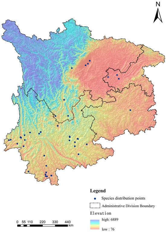
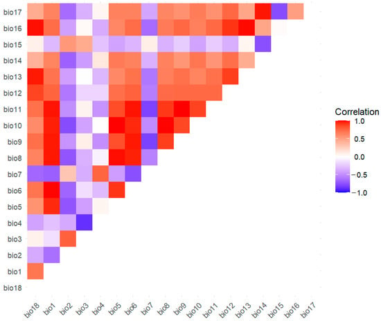
For the L. camara occurrence data, this study used the environmental niche modeling tool ENMTools 5.26 to screen the 80 collected species occurrence records [39]. Specifically, the preprocessed occurrence coordinates, together with the environmental variable layers, were imported into ENMTools. To reduce the spatial clustering and accessibility-related sampling bias typical of herbarium and online-database records [40], ENMTools standardizes the raster resolution of the environmental variables and retains only one occurrence record per grid cell when the spatial distance between records is less than or equal to 1 km, thereby reducing spatial autocorrelation among records and mitigating overfitting when using the MaxEnt model to predict habitat suitability [41]. After processing with ENMTools, 47 valid L. camara occurrence records were retained (Figure 1) and converted to CSV format for subsequent modeling analyses. Although the resulting sample size is modest, MaxEnt has been shown to produce reliable predictions from small occurrence samples, outperforming most alternative algorithms under such conditions [42], and is therefore well suited to this dataset.
Figure 1.
Distribution map of Lantana camara L. in Southwest China (Yunnan Province, Sichuan Province, Guizhou Province, Chongqing Municipality).
2.2.2. Analysis and Treatment of Environmental Factors
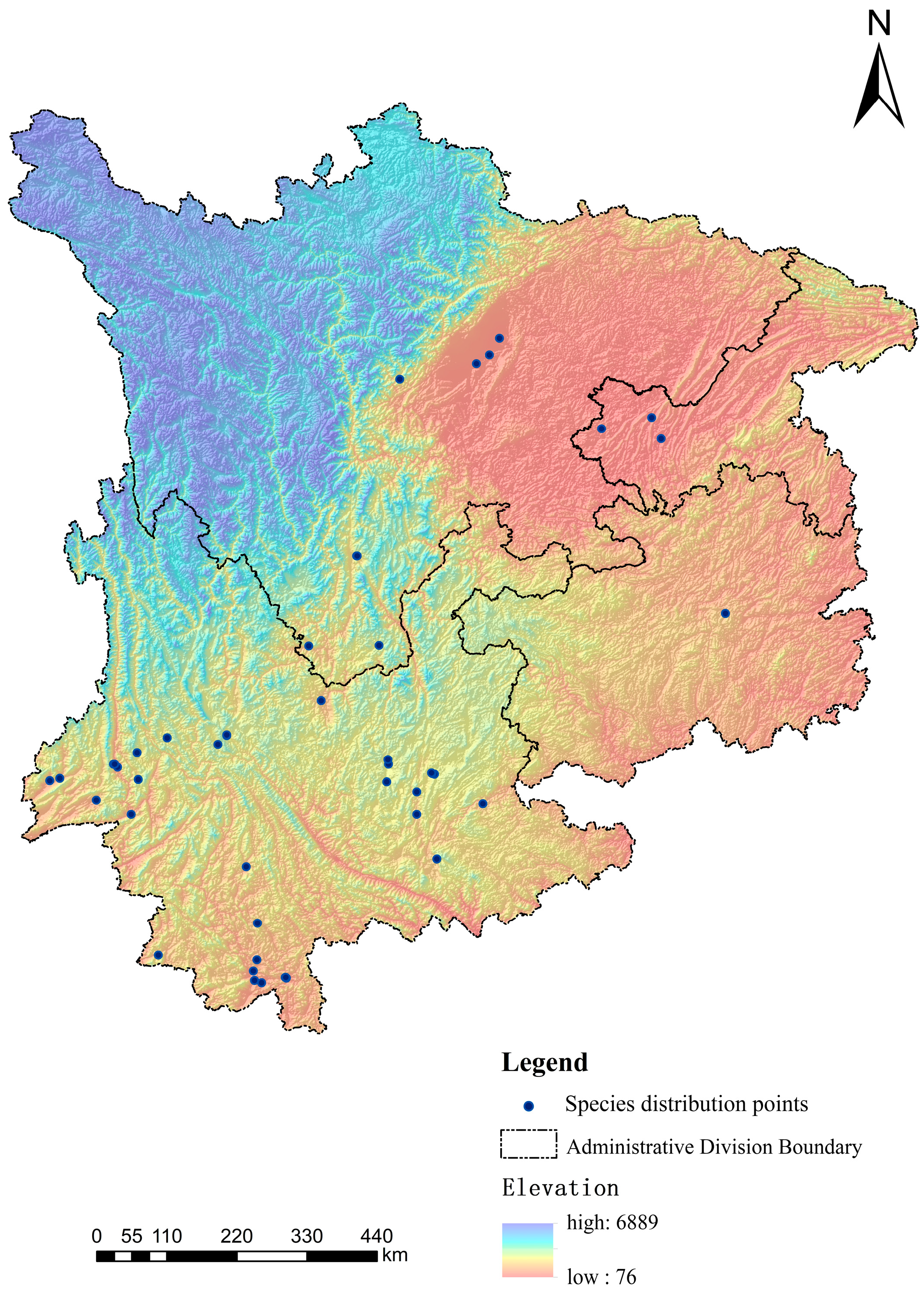
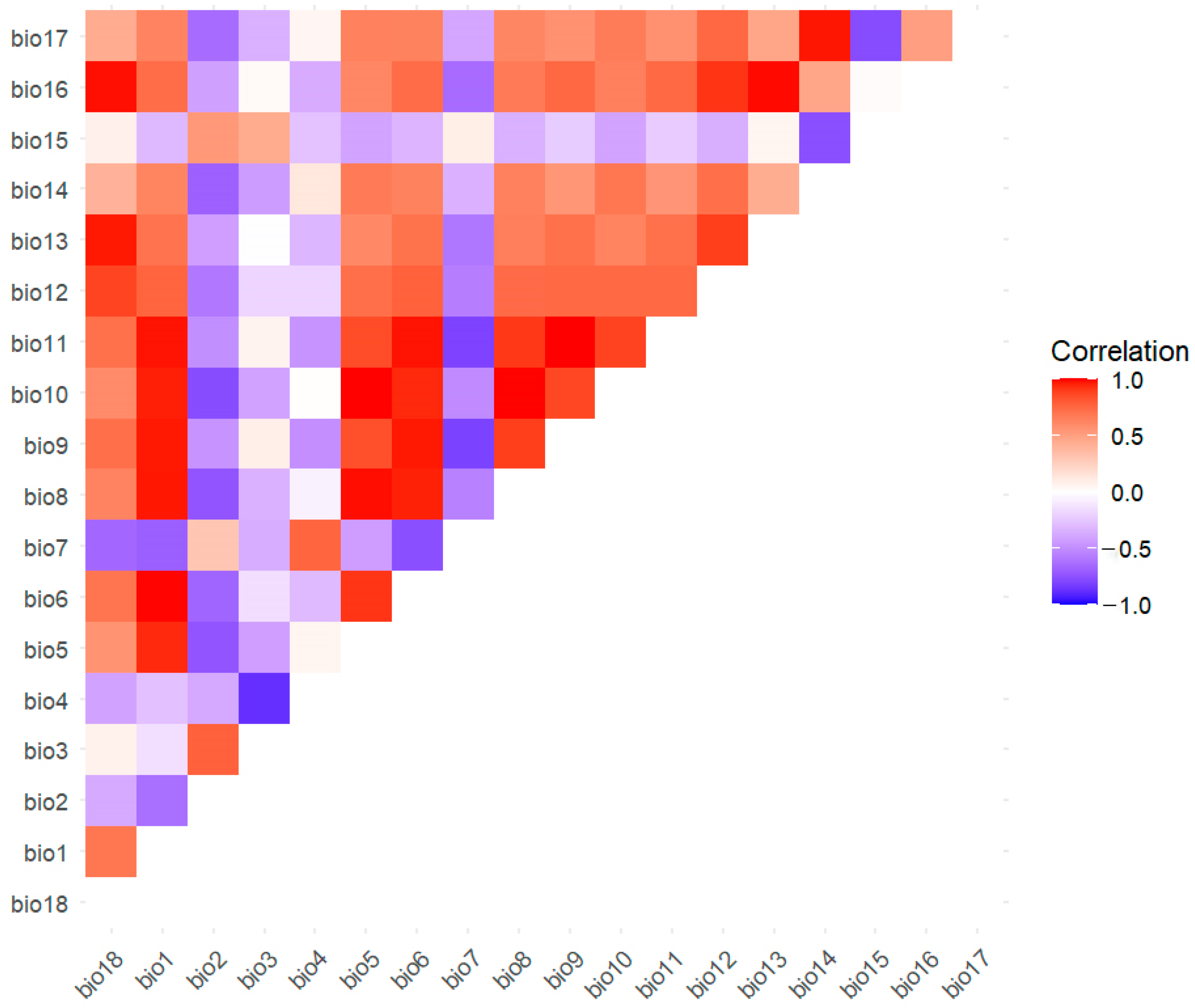
Before modeling, because we considered potential correlations among the selected variables, we imported the 23 preselected environmental factors into the MaxEnt model for preliminary runs and removed variables with a contribution of zero. Next, we used ENMtools to perform correlation analysis on the retained variables. For variable pairs with correlation coefficients |R| ≥ 0.8, we eliminated variables based on lower contribution, retaining only those factors that have a direct ecological interpretability for the distribution of L. camara and a relatively high contribution. We imported the above sample point data and the 23 environmental factor layers into ArcGIS for resampling to obtain values for the corresponding 23 environmental factors, and used Origin 2024 to conduct Pearson correlation analysis on the climatic factors. The results indicate that the bioclimatic variables are mainly positively correlated and exhibit significant inter-variable coupling characteristics (Figure 2).
Figure 2.
The heatmap shows the Pearson correlations between the climate variables used in the MaxEnt modeling.
After experimental screening, 12 variables were retained for model construction: 8 climatic variables; 3 topographic factors (elevation, slope, and aspect); and 1 human activity variable—the Human Footprint Index (see Table 1). Finally, all variables were converted to ASCII grid format (asc) on the ArcGIS 10.8 platform for subsequent model use and analysis.
Table 1.
Final Selection of Representative Factors.
2.3. Model Feature Combination Optimization and Parameter Settings
Although the Maxent model has become one of the most widely used niche models because of its ease of use, the model’s default parameter settings often fail to achieve optimal predictive performance [43]. To enhance the model’s predictive ability, this study optimized the model by adjusting feature combinations. Maxent offers five basic feature types: Linear (L), Quadratic (Q), Product (P), Threshold (T), and Hinge (H). Different combinations of feature types form the model’s set of feature functions. To systematically assess the impact of feature combinations on model performance, this study set six feature combination schemes: L, LQ, H, LQH, LQHP, and LQHPT. Whether a feature is enabled in each combination is determined by the letters present in the combination string, corresponding in the Maxent parameters to enabling linear, quadratic, product, threshold, and hinge features, respectively. This study focused on selecting the best feature combination by comparing the models’ training and test AUCs under different combinations. The selection criterion was defined a priori as the combination achieving the highest test AUC together with the smallest difference between training and test AUC, which indicates the best balance between goodness of fit and generalization. To isolate the effect of feature-class selection, the regularization multiplier was retained at its default value of 1; our optimization was therefore restricted to feature classes rather than the full complexity space of MaxEnt [43]. MaxEnt’s clamping option was set to on; predictions in areas whose environmental conditions exceed the range of the calibration data therefore follow MaxEnt’s standard clamping behavior, i.e., suitability estimates are constrained by the values observed at the edge of the calibration range [44].
3. Results
3.1. Model Tuning and Evaluation
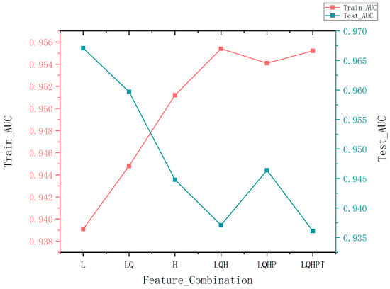
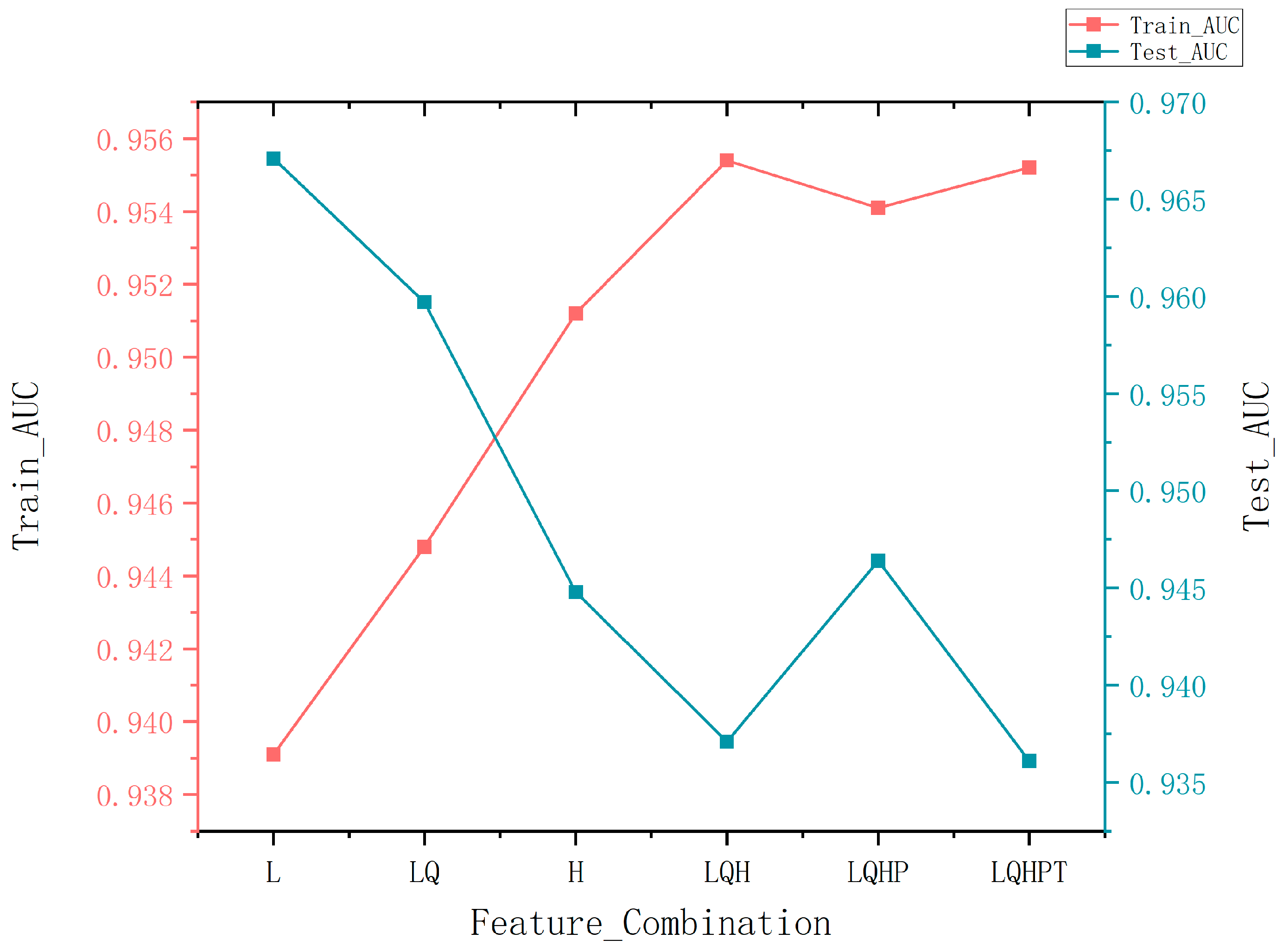
The six candidate feature combinations differed in performance, although the differences in AUC among them were small (training AUC: 0.938–0.945; test AUC: 0.935–0.967; Figure 3). According to the predefined selection criterion, the L (linear-only) combination achieved the highest test AUC (0.9671) while showing the smallest gap between training (0.9391) and test AUC among the top-performing combinations, indicating the best balance between goodness of fit and generalization. We note that the L configuration is also the least complex among the candidates: with linear features only and the default regularization multiplier, the effective number of fitted parameters is minimized, which reduces the risk of overfitting given the limited number of occurrence records (n = 47). Therefore, L was chosen as the feature combination setting for the final model.
Figure 3.
Feature combinations are ordered by descending test AUC.
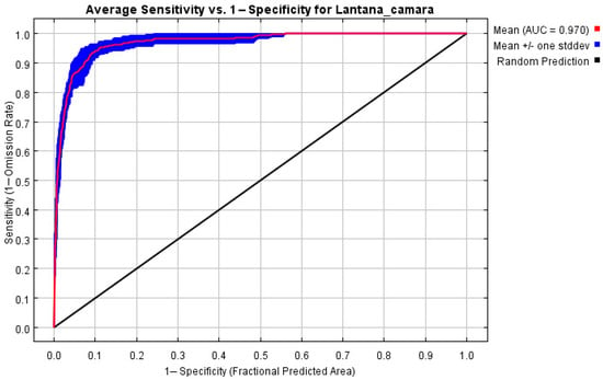
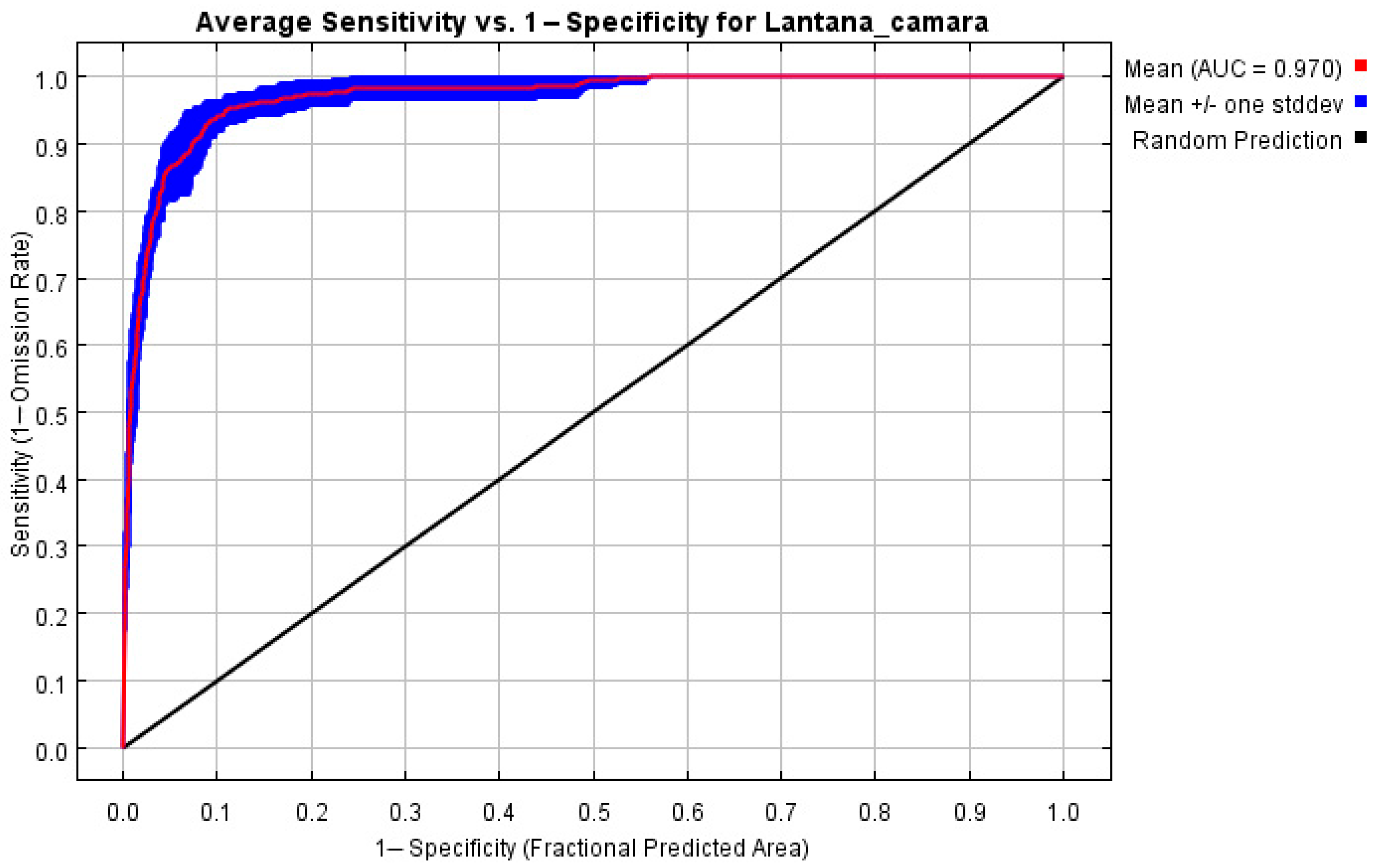
To assess the accuracy of the MaxEnt model predictions, this study used AUC-ROC as the primary evaluation metric. Based on 10 bootstrap replicate runs, with out-of-bag records used as test data, the model’s mean training AUC was 0.970 with a standard deviation of ±0.008, well above the random expectation; the very small standard deviation indicates stable performance across replicates. The mean test AUC across replicates was 0.950 ± 0.030, only 0.02 lower than the training AUC, indicating limited overfitting. At the 10-percentile training presence threshold, the mean training omission rate (OR10) was 0.081, below the nominal expectation of 0.10, indicating that the model does not omit occurrence records beyond expectation. We note, however, that in presence–background models AUC measures internal discriminative ability under the current data rather than transferability to novel conditions (see Section 4.6). The model was therefore considered suitable for subsequent analysis and discussion (see Figure 4).
Figure 4.
AUC-ROC schematic. During validation, the model’s classification accuracy was evaluated using metrics obtained from multiple training iterations. In 10 computational trials, the algorithm achieved an average AUC of 0.970 ± 0.008, indicating robust and reliable performance.
3.2. Key Environmental Factors Affecting the Distribution of Lantana camara
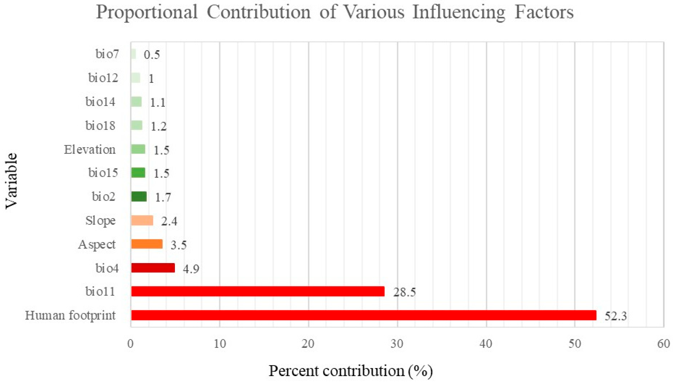
This study used variable importance analysis from a MaxEnt model to quantify the key drivers of Lantana camara’s current distribution in the southwestern region (see Figure 5). The results show that human activity (Human Footprint Index, contribution 52.3%) is the primary determinant of its distribution pattern, with its spread highly dependent on habitats and dispersal pathways created by human disturbance. Among climatic factors, the mean temperature of the coldest quarter (bio 11, contribution 28.5%) contributed the most, indicating that low winter temperatures are a key natural constraint on its expansion to higher latitudes and elevations.
Figure 5.
Proportion chart of each influencing factor.
A comparison of contribution rates and permutation importance further revealed the mechanisms by which each factor operates: the human footprint index and bio11 both rank at the top, confirming their robustness as core variables. The permutation importance of the mean diurnal range (bio 2) and precipitation of the driest month (bio 14) is higher than their contribution rates, suggesting that these two act as key regulatory factors and may influence distribution patterns at local scales.
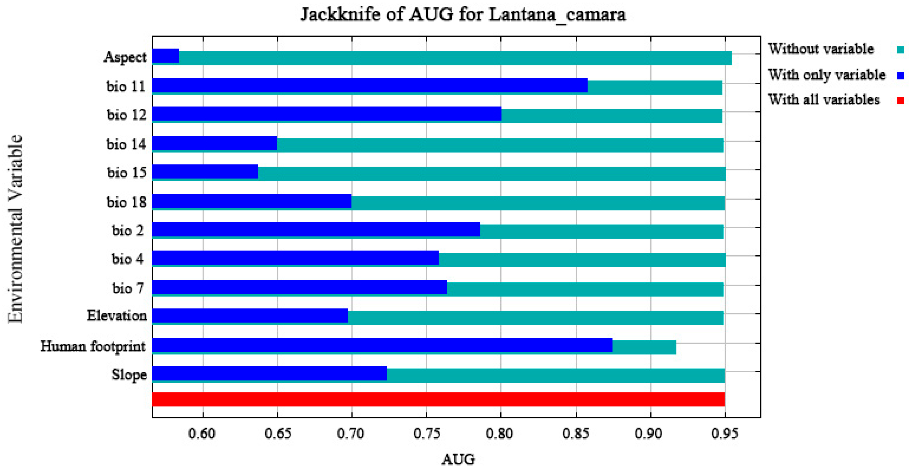
The jackknife test results further reinforced the significance of these variables (see Figure 6). When each variable was used individually, the human footprint index, mean temperature of the coldest quarter (bio 11), and elevation showed markedly higher regularized training gain than the other variables, clearly confirming that these three are the primary determinants of the model’s predictive ability and explaining Lantana camara’s distribution far better than the other environmental factors.
Figure 6.
Schematic diagram of the knife-cut method results for influencing factors.
3.3. Current Potential Geographic Distribution of Lantana camara in the Southwestern Region Under Present Climate Conditions
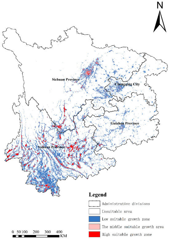
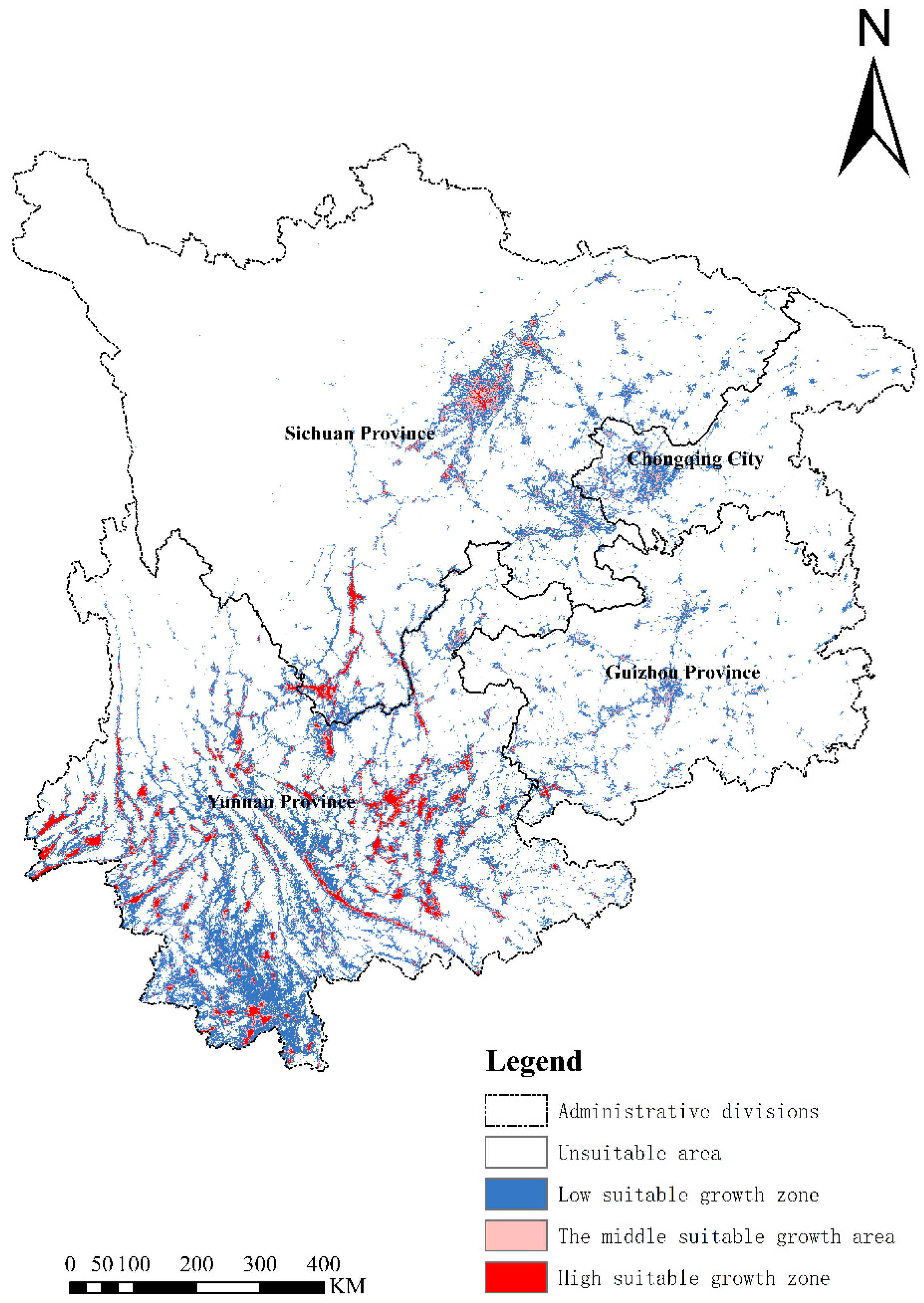
Based on the MaxEnt model results, we used ArcGIS to map the potential geographic distribution of L. camara under current climate conditions in the southwest region (see Figure 7). The map shows that, under current climate conditions, the potential distribution of L. camara in the southwest exhibits an obvious spatial differentiation. The total area of high suitability is about 1.21 × 10⁴ km2, accounting for 1.17% of the study area, mainly distributed in central, southern, and southwestern Yunnan Province, and in Sichuan Province concentrated in Chengdu and Deyang; most areas of Chongqing Municipality and Guizhou Province lack contiguous high-suitability zones, with only sporadic distributions in southwestern Guizhou. The total area of medium suitability is about 2.14 × 10⁴ km2, accounting for 2.07%; it is widespread and dispersed in Yunnan Province, mainly concentrated in Chengdu and Deyang in Sichuan Province, while contiguous medium-suitability areas occur in western Chongqing where it borders Sichuan. The low-suitability area is about 10.52 × 10⁴ km2, accounting for 10.18%, concentrated in southern and southwestern Yunnan, Chengdu in Sichuan, and the main urban and eastern areas of Chongqing, and centered on Guiyang in Guizhou, with scattered distributions elsewhere. The unsuitable areas are mainly distributed in the high-altitude plateau regions in the northwest of the study area, including northwestern Yunnan and Sichuan, characterized by high latitude and high elevation.
Figure 7.
Potential geographic distribution map of Lantana camara L. under current climatic conditions.
3.4. Potential Geographic Distribution Patterns and Dynamic Changes of L. camara in the Southwestern Region Under Different Future Climate Scenarios
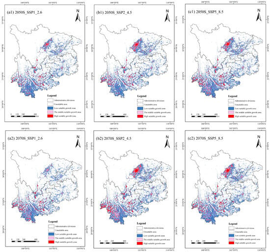
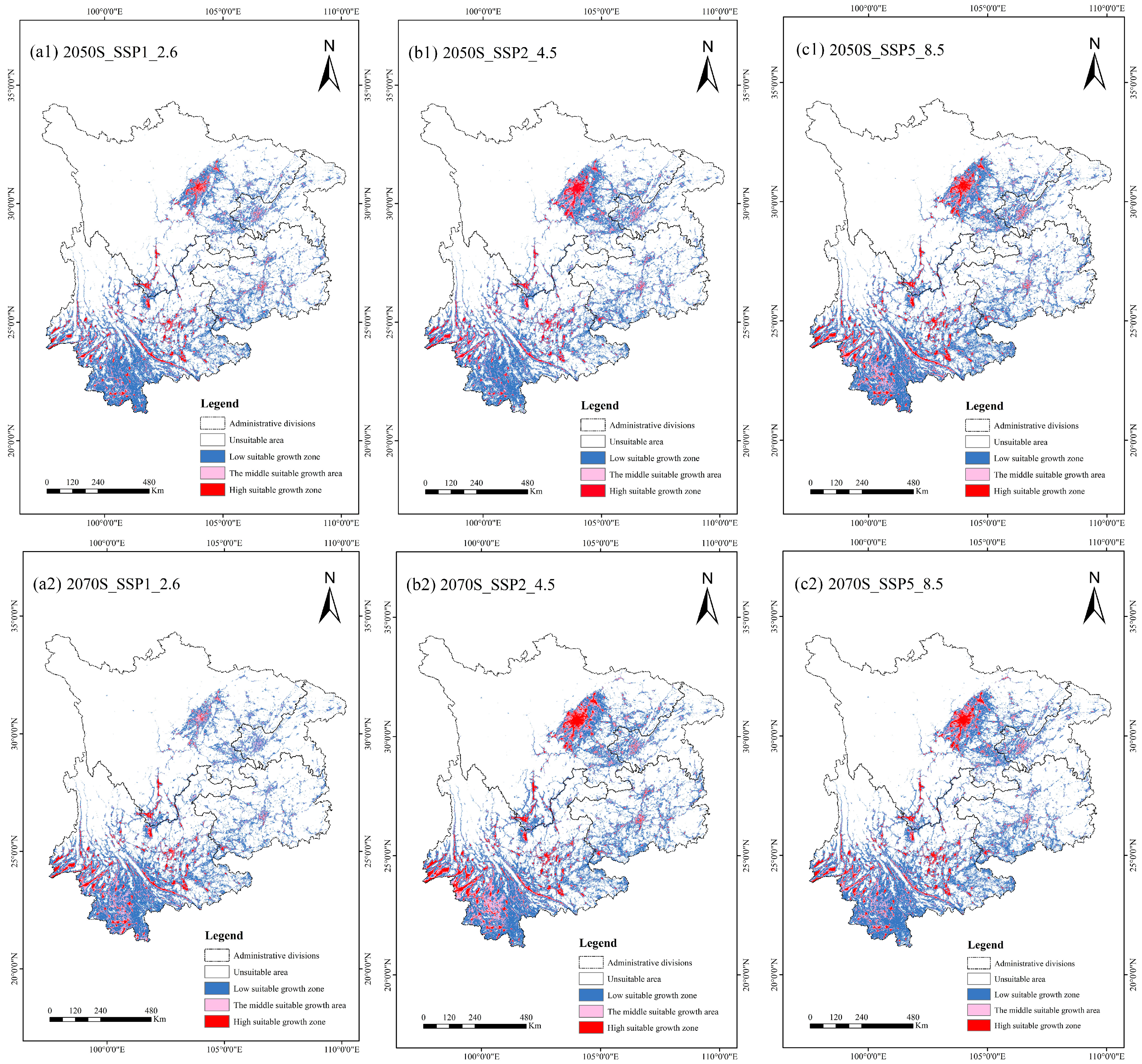
Under future climate scenarios (with the Human Footprint Index held at its present-day level), the potential suitable habitat of L. camara in China’s southwest shows distinct spatiotemporal differentiation (see Figure 8). In the 2050s, the area of suitable habitat continues to expand as emission intensity increases. Under SSP1-2.6, the highly suitable area is 1.87 × 10⁴ km2, accounting for 1.81% of the study area, mainly distributed in central, southern, and southwestern Yunnan, central-southern Sichuan, Chongqing’s main urban area; and southwestern Guizhou. The moderately suitable area is 3.56 × 10⁴ km2, accounting for 3.45%, and the marginally suitable area is 15.38 × 10⁴ km2, accounting for 14.89%, mostly concentrated in low-elevation, densely human-occupied regions, southern Yunnan, and east-central Sichuan. Unsuitable areas are primarily located in the high-altitude regions of Sichuan and Yunnan. Under SSP2-4.5, the areas of all the suitability classes expand; the highly suitable area increases to 2.35 × 10⁴ km2, accounting for 2.28%, concentrated in central-southern Sichuan and central-western Yunnan, with notable distributions in Chongqing and central and southwestern Guizhou. The moderately suitable area is 3.79 × 10⁴ km2, accounting for 3.67%, and the marginally suitable area is 15.77 × 10⁴ km2, accounting for 15.26%; the unsuitable area contracts toward plateau regions. Under SSP5-8.5, the suitable area reaches its 2050s peak: the highly suitable area is 2.82 × 10⁴ km2, accounting for 2.72%, forming contiguous core zones in the Chengdu Plain and Panxi region of Sichuan and in central-western and southern Yunnan. The moderately suitable area is 4.89 × 10⁴ km2, accounting for 4.73%, and the marginally suitable area is 17.12 × 10⁴ km2, accounting for 16.57%, becoming the most widespread suitability class, while unsuitable areas shrink significantly.
Figure 8.
Schematic diagram of changes in the potential geographic distribution of Lantana camara L. under future climate conditions, comparing and analyzing its distribution under three different climate pathways in the 2050s and 2070s. (a1) Geographical distribution of L. camara under the SSP1_2.6 climate scenario in the 2050s. (a2) Geographical distribution of L. camara under the SSP1_2.6 climate scenario in the 2070s. (b1) Geographical distribution of L. camara under the SSP2_4.5 climate scenario in the 2050s; (b2) Geographical distribution of L. camara under the SSP2_4.5 climate scenario in the 2070s. (c1) Geographical distribution of L. camara under the SSP5_8.5 climate scenario in the 2050s; (c2) Geographical distribution of L. camara under the SSP5_8.5 climate scenario in the 2070s.
In the 2070s, the distribution pattern of L. camara diverges under different scenarios. Under the SSP1-2.6 and SSP2-4.5 scenarios, the distribution characteristics are similar: the high-suitability area is 1.91 × 10⁴ km2, accounting for 1.85%, widely distributed in Yunnan and extending outward from the Chengdu Plain in Sichuan; significant distributions also occur in the main urban area of Chongqing and in central and southwestern Guizhou. The medium-suitability area is 3.93 × 10⁴ km2, accounting for 3.81%, forming a continuous gradient around the periphery of the high-suitability area. The low-suitability area is 14.47 × 10⁴ km2, accounting for 14.01%, concentrated in southern Yunnan and central Sichuan. The non-suitable area further contracts toward the western Sichuan Plateau and northwest Yunnan. Under the SSP5-8.5 scenario, a pattern of “contraction of high-suitability areas and expansion of medium- and low-suitability areas” appears: the high-suitability area declines to 1.91 × 10⁴ km2, accounting for 1.85%; the area and spatial pattern of the medium- and low-suitability areas are basically consistent with those of SSP1-2.6 and SSP2-4.5 for the same period, while the non-suitable area is further compressed.
Overall comparisons indicate that, under the SSP1-2.6 and SSP2-4.5 scenarios, from the 2050s through the 2070s, the areas of highly suitable and moderately suitable habitat for L. camara continuously increase while unsuitable areas steadily shrink, meaning that climate warming progressively enhances its habitat suitability; under the high-emission SSP5-8.5 scenario, however, highly suitable areas in the 2070s are noticeably reduced compared with the 2050s, with only moderate- and low-suitability zones continuing to expand, suggesting that extreme high temperatures may exceed its growth thresholds. Over the same period, the total suitable area increases overall with higher emission intensity, with more pronounced expansion in the 2050s. Spatially, highly suitable areas remain concentrated in low-elevation regions with intensive human activity, while high-elevation cold regions such as the western Sichuan Plateau and northwest Yunnan persistently serve as major unsuitable areas, constituting key constraints on its spread.
3.5. Contraction and Expansion of Suitable Habitat Areas for Lantana camara Under Future Climate Conditions
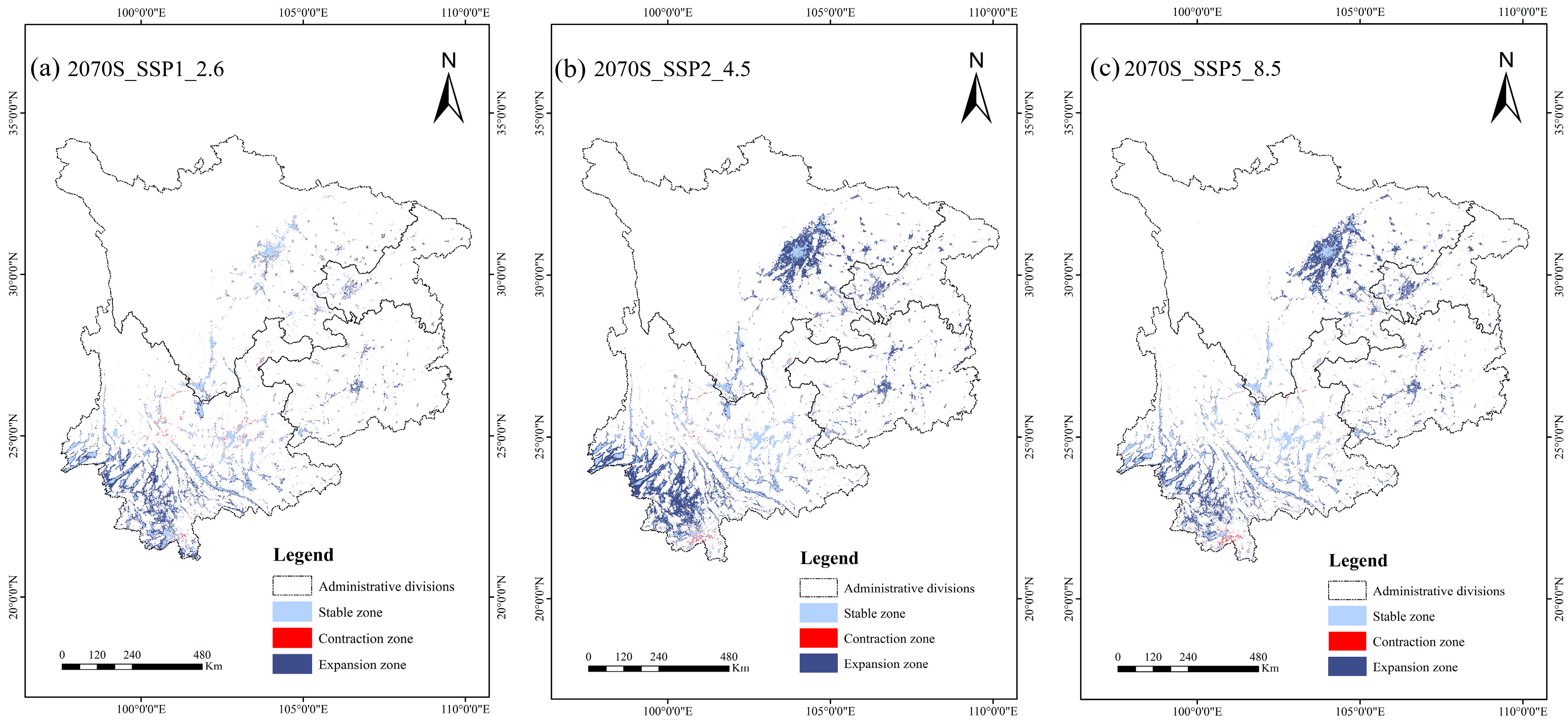
By the 2070s, the spatiotemporal dynamics of suitable colonization areas for L. camara evolve differently according to the climate scenario’s emissions intensity. Overall expansion dominates, but the patterns and intensities differ markedly (see Figure 9). Under the low-emission SSP1-2.6 scenario, changes in suitable areas are mainly expansion and stability, with localized contractions: expansion zones concentrate on the western and southern margins of Yunnan and around Guiyang; stable zones are the core suitable areas in central-eastern Yunnan and south-central Sichuan; contraction zones are scattered along the edges of the suitable areas. Under the medium-emission SSP2-4.5 scenario, the expansion trend is more pronounced, showing a continuous northward spread: a contiguous expansion belt forms from western to northeastern Yunnan; the edges of the southern Sichuan basin, the Panxi region, central Chongqing, and western Guizhou all show clear expansion; stable areas remain in central Yunnan, the Chengdu Plain, and around Guiyang; contraction areas appear only sporadically along the southwestern edge of Yunnan. Under the high-emission SSP5-8.5 scenario, the pattern becomes more complex, with the largest expansion extent, the reshaping of the stable-area structure, and a notable increase in contraction zones: expansion areas advance to higher latitudes and mid-elevations, with new contiguous expansion zones emerging in southern Sichuan and central Chongqing; the stability of some core suitable areas is challenged, showing interwoven expansion and contraction at their margins and interiors; the number of contraction zones increases, and they form contiguous distributions, concentrated at the northern edges of suitable areas, at high elevations, and in ecologically vulnerable regions.
Figure 9.
Schematic diagram of the contraction and expansion of suitable establishment areas for Lantana camara L. under future climate conditions.
3.6. Centroid Shifts of Suitable Colonization Areas for Lantana camara in Southwest China Under Climate Change Conditions
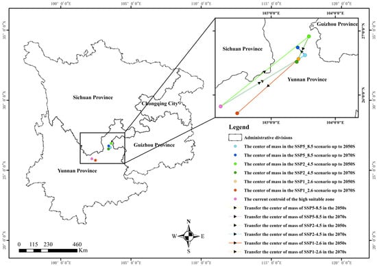
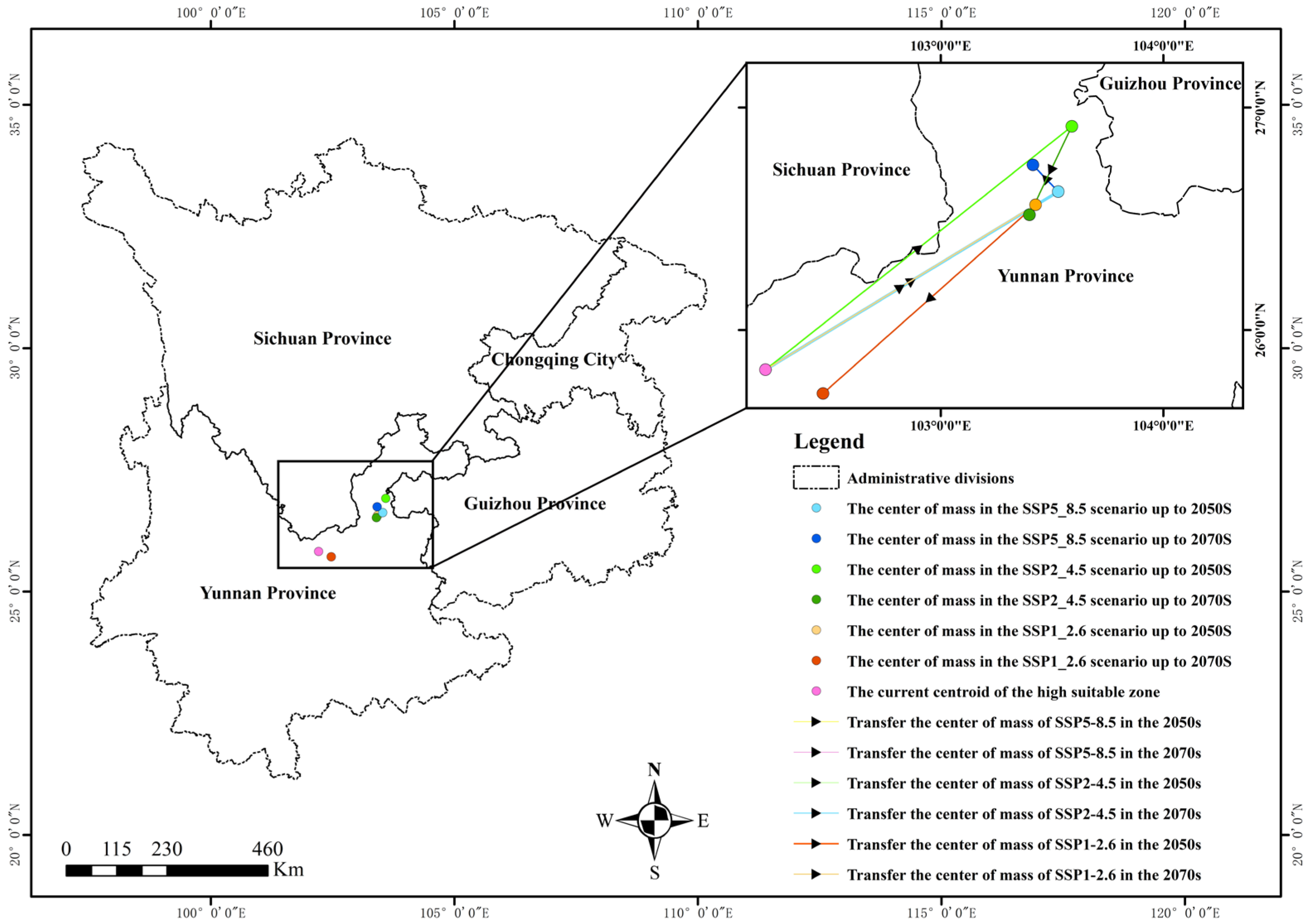
As shown in Figure 10, under current climatic conditions, the potential geographic distribution centroid of L. camara within the study area is located in Chuxiong Yi Autonomous Prefecture, Yunnan Province. By the 2050s, under all three climate scenarios (SSP1-2.6, SSP2-4.5, SSP5-8.5), the distribution centroid shows a northeastward migration trend, eventually locating in Qujing City, Yunnan Province. By the 2070s, the centroid migration directions diverge under different climate scenarios: under SSP1-2.6, the centroid does not continue the northeastward trend but shifts southwest into Kunming; under SSP2-4.5, the centroid also moves southwest but remains within Qujing, while under SSP5-8.5, the centroid continues migrating northeast and stays within Qujing.
Figure 10.
Schematic diagram of centroid shifts of suitable colonization areas of Lantana camara L. in southwest China under climate change conditions.
4. Discussion
The results of this study are broadly consistent with the current mainstream understanding of the invasion ecology of L. camara: human activities, temperature conditions, and topographic factors are the leading predictors associated with its spread and establishment. However, this study also observed nonlinear responses that differ from traditional expectations: under the high-emission SSP5-8.5 scenario, highly suitable areas contract in the 2070s, contradicting the linear expectation that continued climate warming will promote the expansion of suitable areas. This pattern is consistent with the hypothesis that extreme warming may exceed the species’ optimal thermal range in its core suitable habitats—a mechanism that remains to be tested (see Section 4.2). At the same time, its distribution centroid shows nondirectional, nonlinear migration characteristics across different periods and scenarios, especially a persistent northeastward shift under the high-emission pathway—a feature that has been less revealed in previous single-scenario or short-term studies. Overall, through multi-scenario, long-term simulations, this study systematically revealed the complex dynamics of the distribution of L. camara under climate change, providing new evidence for elucidating the spatial response patterns of invasive plants to climate change and offering scientific support for the precision management and control of regional invasive species. We emphasize that MaxEnt variable contributions, permutation importance, and jackknife results identify variables that contribute strongly to model predictions; they do not by themselves establish ecological causation, and the mechanistic interpretations below should be read as hypotheses consistent with the modeled associations.
4.1. Key Factors and Distribution Characteristics of the Potential Distribution of Lantana camara Under Current Climatic Conditions
This study shows that human activities, low winter temperatures, and topography are the leading predictors of the current distribution pattern of L. camara in southwestern China. The Human Footprint Index has the highest contribution rate (52.3%), indicating that its distribution is strongly associated with human-mediated dispersal pathways. This modeled association is consistent with independent, non-modeling evidence: the documented invasion history of the species began with ornamental introduction in cities and proceeded along transportation routes (see Section 4.4), so a strong overlap between suitable habitat and areas of intensive human activity is exactly the pattern that this invasion history predicts. High-suitability areas are concentrated in central Yunnan and surrounding regions with intensive human activity, further supporting the prominent role of human disturbance in its spread.
Among climate factors, the mean temperature of the coldest quarter (bio11, contribution 28.5%) is the primary natural predictor; low winter temperatures appear to prevent L. camara from safely overwintering in high-altitude, high-latitude cold areas, which is consistent with the species’ tropical origin and frost sensitivity, and therefore northwestern Yunnan and the western Sichuan Plateau have long remained unsuitable. Topographic factors (elevation, slope, aspect) affect local water and heat redistribution, influencing its colonization success and causing the suitable areas in the southwestern mountains to be markedly fragmented and spatially heterogeneous [45]. Overall, the current distribution of L. camara is characterized by “human-driven spread, boundaries defined by low temperature, and local modulation by topography”.
4.2. Factors Influencing the Climate Change-Driven Dynamics of Lantana camara, Its Spread Trends, and Invasion Risk Under Future Climate Conditions
Under future climate scenarios, changes in the suitable habitat of L. camara show pronounced scenario dependence and nonlinear responses. In the 2050s, suitable areas expand overall under all emission pathways and increase with greater radiative forcing; by the 2070s, the scenarios diverge markedly: under SSP1-2.6 and SSP2-4.5, high-suitability areas continue to expand, with SSP2-4.5 exhibiting the largest expansion—about a 170% increase over the present—indicating that moderate warming is most conducive to its large-scale spread and northward migration.
Notably, the dominant climatic predictor in our model is bio11 (mean temperature of the coldest quarter), which characterizes cold limitation and is consistent with the species’ tropical origin and frost sensitivity. The projected contraction of highly suitable habitat in the 2070s under SSP5-8.5 is therefore unlikely to reflect a relaxation of cold limits; we hypothesize that it may instead be associated with warming in the low-latitude core range exceeding the species’ optimal thermal range. This interpretation is offered as a hypothesis consistent with the modeled associations rather than a demonstrated mechanism, and it requires validation with response-curve analyses and physiological evidence (see Section 4.6). Meanwhile, new suitable areas appear in the northern region as low-temperature constraints are relieved [46]. Overall, a spatial reconfiguration of “retreat to the south and advance to the north” is projected, suggesting that the invasion risk of L. camara does not increase linearly with climate warming: moderate warming promotes spread, whereas extreme warming may trigger local degradation of original suitable areas and shift suitability toward higher latitudes [47]. We caution, however, that future projections inevitably involve some degree of extrapolation into non-analog climates, and the projected contraction should be interpreted with this uncertainty in mind (see Section 4.6). As these projections rely on a single GCM, the projected contraction may vary across climate models (see Section 4.6).
From an ecological risk perspective, L. camara is predicted to further expand into key biodiversity areas in the southwest. For example, southwestern and southern Yunnan are among the most biodiverse regions and contain multiple reserves and their critical ecosystems; the suitable habitat distribution of L. camara has clearly already expanded extensively across these parts. At the same time, L. camara has very strong interspecific competitive ability and can suppress the regeneration of native plants through allelopathy, reducing community diversity and posing a long-term threat to the stability of nature reserves, forest, and wetland ecosystems.
4.3. Centroid Migration Patterns and Driving Factors of Lantana camara Distribution
The migration trajectory of the centroid of L. camara distribution intuitively reflects the synergistic driving effects of climate change and human activities. The current centroid is located in Chuxiong Prefecture, Yunnan Province, and under all three scenarios for the 2050s, it shifts toward the northeast; this is a typical manifestation of northward plant migration driven by climate warming [48]. Warming alleviates low-temperature constraints in the north, making high-latitude areas more suitable for its survival and establishment. At the same time, higher urbanization and human activity intensity in northeastern Yunnan, western Guizhou, and southern Sichuan further accelerate its spread and establishment.
By the 2070s, centroid migration shows scenario divergence: under SSP1-2.6 and SSP2-4.5, the centroid shifts slightly back to the southwest, mainly constrained by topography and local land-use patterns; under SSP5-8.5, the centroid continues to migrate northeast, indicating that extreme warming further intensifies the northward trend and drives it to seek suitable habitats at higher latitudes. The overall migration trend indicates that the invasion core of L. camara is gradually shifting northward, and future control efforts must focus on the northern expansion front.
4.4. Interpretation of the Spread of Lantana camara from Urban Areas to Nonurbanized Regions
The invasion history of L. camara exhibits the typical “ornamental horticulture introduction–escape from artificial environments–invasion of natural ecosystems” pattern, with its dispersal pathways showing high consistency on a global scale [49]. Existing studies indicate that the earliest records of L. camara in China can be traced back to the late Ming Dynasty (1368–1644), when it was first introduced to Taiwan as an ornamental flower [50]. With its brightly colored flowers, strong adaptability, and ease of reproduction, the species was rapidly promoted in urban landscaping and courtyard cultivation, gradually escaping from cultivation and spreading on a large scale through a combination of transportation networks, human activities, and natural dispersal.
Previous studies have shown that, after its introduction into China, L. camara followed the classic pathway of “ornamental introduction–urban establishment–suburban spread–natural invasion”. Initially cultivated for horticultural ornamentation, it was widely planted in parks, road green belts, and residential green spaces in major southwestern cities such as Kunming, Chengdu, and Chongqing [51]. The warm, humid climate of the southwest is suitable for its growth, and with the long-term promotion of urban greening, it became a common landscape plant. Subsequently, due to escape and spread, invasive populations formed in southwestern urban, rural, and natural habitats, posing a threat to biodiversity.
After establishing populations in cities, L. camara begins to penetrate suburban and natural areas along transportation routes, tourist corridors, field edges, and mountain forest margins. In this stage, human activities (tourism, nursery plant transport, soil disturbance) combined with natural dispersal (wind, water flow, animal vectors) drive its spread from cultivated landscapes into wastelands, slopes, secondary forests, and shrublands [52]. As dispersal continues, L. camara gradually breaks free from urban landscape constraints, enters semi-natural ecosystems, and eventually invades primary or near-natural systems such as forests, wetlands, river valleys, and nature reserves, completing the full invasion process from urbanized landscapes into nonurban natural ecosystems.
In the southwestern China region covered by this study, the spread of L. camara follows the same pattern: urban cores serve as invasion sources, suburban and low hilly areas as diffusion transition zones, and nature reserves and mountain ecosystems as ultimate invasion targets. This urban-to-nonurban diffusion pathway not only explains the current spatial pattern of high overlap between its suitable habitats and areas of intensive human activity, but also confirms the dominant role of human activities throughout the entire invasion process.
4.5. Comprehensive Analysis of the Utilitarian Value and Invasive Harm of Lantana camara
On the positive side, L. camara has certain utilizable potential in specific contexts. First: it has notable ornamental value—its flowers are richly colored and bloom for a long time, and it has a compact habit, so it has been widely used in urban landscaping, hedges, and garden ornamentation. Second, it has ecological restoration potential—its roots are well developed and it is drought- and poor-soil-tolerant, so it can play a role in soil and water conservation and vegetation recovery in degraded wastelands and quarry sites [53]. Third, it has high resource-utilization value—its branches and leaves contain various secondary metabolites, offering potential for development in medicine, antioxidants, and antibacterial applications [35,54,55].
The negative aspects include the following. First: Lantana camara’s strong competitiveness and exclusivity—fast growth, high fruit production, and vegetative reproduction—enable it to rapidly form single-species-dominant stands that, through resource competition and allelopathic effects, strongly inhibit the regeneration of native plants, squeezing the living space of local species and even causing local decline and disappearance [56]. Second, it can cause significant ecosystem damage: after invasion, it alters the community structure, reduces biodiversity, affects soil microorganisms and nutrient cycles, and lowers the ecosystem’s stability and resilience to disturbance [57]. Third, it carries production and health risks: the whole plant is toxic and can harm livestock and poultry, and it invades farmland, orchards, and commercial forests, affecting crop yields and quality [58]. Fourth, it is extremely difficult to control: once established, it is hard to eradicate completely and requires long-term continuous management, incurring high economic and ecological costs [59].
In summary, although L. camara has some ornamental and resource potential, its invasive harm is long-term, widespread, and irreversible; it poses a serious threat to regional biodiversity, ecological security, and agricultural production, and is a typical invasive plant whose harms far outweigh its benefits, requiring strict control and source-level prevention.
4.6. Limitations
Although this study systematically modeled the potential geographic distribution of L. camara, several limitations should be acknowledged. First, the model was calibrated with only 47 spatially thinned occurrence records, and herbarium and GBIF records are subject to accessibility-related sampling bias; although 1-km thinning mitigates spatial clustering [40] and MaxEnt performs relatively robustly with small samples [42], residual bias may partly inflate the apparent contribution of the Human Footprint Index. Second, only feature classes were tuned, with the regularization multiplier retained at its default value of 1, and model evaluation relied primarily on AUC from replicated bootstrap resampling, which assigns spatially structured records to training and test sets at random and may therefore inflate apparent performance; joint tuning of feature classes and the multiplier (e.g., using ENMeval or kuenm, with selection based on AICc or omission rates), spatially structured (block) cross-validation, and complementary metrics such as partial ROC and AICc are recommended. Third, the Human Footprint Index was held constant and projections rely on a single GCM (BCC-CSM2-MR, which performs well over China) [37]; the projections therefore represent climate scenarios conditional on present-day anthropogenic pressure, and inter-model uncertainty remains unquantified. Fourth, the model was calibrated on invaded-range records of a still-expanding species, so the fitted niche may truncate its true tolerances, and projections involve some extrapolation into non-analog climates; although clamping was enabled [44], the SSP5-8.5 contraction should be interpreted cautiously, and novelty diagnostics (e.g., MESS) are warranted. Finally, the environmental variable suite could be further expanded (e.g., nighttime lights, higher-resolution GDP), and the mechanisms of niche replacement and community succession in areas of future habitat contraction remain unclear, warranting community surveys combined with species competition models. None of these limitations alters the qualitative conclusion that human activity and winter cold jointly shape the present distribution of L. camara, but they bound the strength of mechanistic inferences from the future projections.
5. Conclusions
Systematic MaxEnt modeling reveals that human activities (52.3%) and low winter temperatures (28.5%) jointly govern the current distribution of L. camara in southwest China, with highly suitable habitats concentrated in human-intensive areas, such as central Yunnan and the Chengdu periphery, following an urban-origin, urban–rural diffusion pattern. Climate warming drives a scenario-dependent nonlinear response: under SSP2-4.5, highly suitable habitat increases by ~170% by the 2070s, whereas SSP5-8.5 triggers the contraction of core southern ranges accompanied by local degradation, resulting in a “retreat southward and advance northward” restructuring with a continuously northeastward-shifting centroid. As a horticultural escapee, L. camara completes a full invasion pathway from urban establishment to ecosystem incursion, exerting long-term, irreversible impacts that severely threaten native flora and biodiversity hotspots, particularly in Yunnan. We advocate integrating cross-regional coordinated prevention and control into territorial spatial planning and ecological red-line management, including removal operations in biodiversity hotspots, three-dimensional monitoring of dispersal corridors, strict regulation of ornamental introductions, native species substitution, and whole-society enforcement and outreach, to safeguard regional ecological security and provide a global reference.
Author Contributions
T.T. and Z.H. conceived and supervised the research. Y.Z., M.C. and S.S. collected all plant specimens. M.C. performed the taxonomic identification of all plant samples. Y.Z. and S.S. conducted the relevant experiments and analyzed the data. Y.Z. and M.C. drafted the manuscript. T.T. and Z.H. revised the manuscript. Y.Z. and M.C. have made equal contributions to this work. All authors have read and agreed to the published version of the manuscript.
Funding
This study was supported by the 2023 Central Government Financial Forestry and Grassland Ecological Protection and Restoration Fund Program, which received funding from the Shangri-La National Park Establishment Project (Grant No. 2507-533400-04-05-476224).
Data Availability Statement
The original contributions presented in this study are included in the article. Further inquiries can be directed to the corresponding authors.
Acknowledgments
This study was funded by two key laboratories of Southwest Forestry University. We thank the Shangri-La Potatso National Park Bita Lake Wetland Observation Station for field data support. We sincerely appreciate the anonymous reviewers and editors for their constructive comments. Gratitude is also given to our research team for data processing, model optimization and academic discussion. Finally, we thank our families and friends for their consistent support.
Conflicts of Interest
The authors declare no conflicts of interest.
References
- Hulme, P.E. Unwelcome Exchange: International Trade as a Direct and Indirect Driver of Biological Invasions Worldwide. One Earth 2021, 4, 666–679. [Google Scholar] [CrossRef] [Scilit]
- Li, X.; Yu, M.; Li, J. Research Progress on Plant Invasion Mechanism. Bull. Biol. 2020, 55, 5–9. [Google Scholar]
- Simberloff, D.; Rejmanek, M. (Eds.) Encyclopedia of Biological Invasions; University of California Press: Oakland, CA, USA, 2011; Volume 3. [Google Scholar]
- Foxcroft, L.C.; Pickett, S.T.A.; Cadenasso, M.L. Expanding the Conceptual Frameworks of Plant Invasion Ecology. Perspect. Plant Ecol. Evol. Syst. 2011, 13, 89–100. [Google Scholar] [CrossRef] [Scilit]
- Tsiftsis, S.; Merou, T.; Doroftei, M.; Kvach, Y.; Karakoç, F.T.; Mikeladze, I.; Covaliov, S.; Damianidis, C.; Ene, L.; Erüz, C.; et al. Invasive Alien Plant Species in Black Sea Delta Protected Areas: Patterns, Impacts, and Management Recommendations. Diversity 2026, 18, 350. [Google Scholar] [CrossRef] [Scilit]
- Edrisi, S.A.; El-Keblawy, A.; Abhilash, P.C. Sustainability Analysis of Prosopis juliflora (Sw.) DC Based Restoration of Degraded Land in North India. Land 2020, 9, 59. [Google Scholar] [CrossRef] [Scilit]
- Kato-Noguchi, H.; Kurniadie, D. Allelopathy of Lantana camara as an Invasive Plant. Plants 2021, 10, 1028. [Google Scholar] [CrossRef] [Scilit]
- Lowe, S.; Browne, M.; Boudjelas, S. 100 of the World’s Worst Invasive Alien Species: A Selection from The Global Invasive Species Database. In Encyclopedia of Biological Invasions; Simberloff, D., Rejmanek, M., Eds.; University of California Press: Oakland, CA, USA, 2019; pp. 715–716. [Google Scholar]
- Yang, Y.; Bian, Z.; Ren, W.; Wu, J.; Liu, J.; Shrestha, N. Spatial Patterns and Hotspots of Plant Invasion in China. Glob. Ecol. Conserv. 2023, 43, e02424. [Google Scholar] [CrossRef] [Scilit]
- Ndagurwa, H.G.T.; Dlodlo, A.B.; Maponga, T.S.; Muvengwi, J. Lantana camara Reduces Grass Species and Functional Diversity in a Semi-Arid Southern African Savanna. Ecol. Front. 2026, 46, 1582–1589. [Google Scholar] [CrossRef] [Scilit]
- Yan, Y.; Xian, X.; Jiang, M.; Wan, F. Biological Invasion and Its Research in China: An Overview. In Biological Invasions and Its Management in China; Invading Nature—Springer Series in Invasion Ecology; Springer, 2017; Volume 11. [Google Scholar]
- Johnson, B.A.; Mader, A.D.; Dasgupta, R.; Kumar, P. Citizen Science and Invasive Alien Species: An Analysis of Citizen Science Initiatives Using Information and Communications Technology (ICT) to Collect Invasive Alien Species Observations. Glob. Ecol. Conserv. 2020, 21, e00812. [Google Scholar] [CrossRef] [Scilit]
- Joshi, V.C.; Chandra, N.; Sundriyal, R.C.; Arya, D.; Mishra, A.P.; Abdo, H.G. Ecological Status and Spatial Extent of Non-Native Shrubs Lantana camara L. and Ageratina adenophora Sprengel in the Forest Communities of Western Himalaya. Trees For. People 2024, 15, 100494. [Google Scholar] [CrossRef] [Scilit]
- Sanders, R.W. Taxonomy of Lantana Sect. Lantana (Verbenaceae): II. Taxonomic Revision. J. Bot. Res. Inst. Tex. 2012, 6, 403–441. [Google Scholar]
- Sharma, O.P.; Makkar, H.P.S.; Dawra, R.K. A Review of the Noxious Plant Lantana camara. Toxicon 1988, 26, 975–987. [Google Scholar] [CrossRef] [Scilit]
- Wang, C.-J.; Wan, J.-Z. Assessing the Habitat Suitability of 10 Serious Weed Species in Global Croplands. Glob. Ecol. Conserv. 2020, 23, e01142. [Google Scholar] [CrossRef] [Scilit]
- Shi, N.; Wang, C.; Wang, J.; Wu, N.; Naudiyal, N.; Zhang, L.; Wang, L.; Sun, J.; Du, W.; Wei, Y.; et al. Biogeographic Patterns and Richness of the Meconopsis Species and Their Influence Factors across the Pan-Himalaya and Adjacent Regions. Diversity 2022, 14, 661. [Google Scholar] [CrossRef] [Scilit]
- Zhang, X.; Wang, G.; Peng, P.; Zhou, Y.; Chen, Z.; Feng, Y.; Wang, Y.; Shi, S.; Li, J. Influences of Environment, Human Activity, and Climate on the Invasion of Ageratina adenophora (Spreng.) in Southwest China. PeerJ 2023, 11, e14902. [Google Scholar] [CrossRef] [Scilit]
- Taylor, S.; Kumar, L.; Reid, N.; Kriticos, D.J. Climate Change and the Potential Distribution of an Invasive Shrub, Lantana camara L. PLoS ONE 2012, 7, e35565. [Google Scholar] [CrossRef] [Scilit]
- Liu, B.; Lin, M.; Liu, S.; Ye, X.; Chen, S. National-Scale Conservation Gaps and Priority Areas for Invasive Plant Control in China: An Integrated MaxEnt-InVEST Framework. Plants 2026, 15, 898. [Google Scholar] [CrossRef] [Scilit]
- Ahmad, R.; Khuroo, A.A.; Hamid, M.; Charles, B.; Rashid, I. Predicting Invasion Potential and Niche Dynamics of Parthenium hysterophorus (Congress Grass) in India under Projected Climate Change. Biodivers. Conserv. 2019, 28, 2319–2344. [Google Scholar] [CrossRef] [Scilit]
- Adhikari, P.; Lee, Y.-H.; Park, Y.-S.; Hong, S.-H. Assessment of the Spatial Invasion Risk of Intentionally Introduced Alien Plant Species (IIAPS) under Environmental Change in South Korea. Biology 2021, 10, 1169. [Google Scholar] [CrossRef] [Scilit]
- Phillips, S.J.; Dudík, M.; Schapire, R.E. A Maximum Entropy Approach to Species Distribution Modeling. In Proceedings of the Twenty-First International Conference on Machine Learning—ICML ’04, Banff, AB, Canada; ACM Press: New York, NY, USA, 2004; p. 83. [Google Scholar]
- Wisz, M.S.; Hijmans, R.J.; Li, J.; Peterson, A.T.; Graham, C.H.; Guisan, A. NCEAS Predicting Species Distributions Working Group. Effects of Sample Size on the Performance of Species Distribution Models. Divers. Distrib. 2008, 14, 763–773. [Google Scholar] [CrossRef] [Scilit]
- Zhang, K.; Yao, L.; Meng, J.; Tao, J. Maxent Modeling for Predicting the Potential Geographical Distribution of Two Peony Species under Climate Change. Sci. Total Environ. 2018, 634, 1326–1334. [Google Scholar] [CrossRef] [Scilit]
- Li, Y.; Li, M.; Li, C.; Liu, Z. Optimized Maxent Model Predictions of Climate Change Impacts on the Suitable Distribution of Cunninghamia lanceolata in China. Forests 2020, 11, 302. [Google Scholar] [CrossRef] [Scilit]
- Zhu, G.; Liu, Q.; Gao, Y. Improving Ecological Niche Model Transferability to Predict the Potential Distribution of Invasive Exotic Species. Biodivers. Sci. 2014, 22, 223. [Google Scholar] [CrossRef] [Scilit]
- Elith, J.; Phillips, S.J.; Hastie, T.; Dudík, M.; Chee, Y.E.; Yates, C.J. A Statistical Explanation of MaxEnt for Ecologists: Statistical Explanation of MaxEnt. Divers. Distrib. 2011, 17, 43–57. [Google Scholar] [CrossRef] [Scilit]
- Zhong, W.; Wei, X.; Yu, Y.; Tang, X.; Zhang, Y.; Huang, X.; Li, X.; Liu, Y.; Li, D. Predicting Potential Suitable Areas of Orchidaceae Plants with National Key Reserve from Heilongjiang Province in MaxEnt Models. Ecol. Front. 2025, 46, 18–28. [Google Scholar] [CrossRef] [Scilit]
- Liu, Y.; Zeng, B.; Han, W.; Su, X.; Chen, L.; Zhang, M.; Li, C.; Shi, S.; Liu, G. Predicting Distributions of Toxic Weed Species in Alpine Grasslands under Climate Change Using MaxEnt Model. Ecol. Front. 2025, 45, 1823–1833. [Google Scholar] [CrossRef] [Scilit]
- Xu, H.; Jiang, C.; Li, X.; Fan, H.; Wang, J.; Li, J. Optimized MaxEnt Modeling Reveals Major Decline and Shift of Giant Panda Habitat under CMIP6 Ensemble Projections. Ecol. Indic. 2025, 179, 114150. [Google Scholar] [CrossRef] [Scilit]
- Diez, J.M.; D’Antonio, C.M.; Dukes, J.S.; Grosholz, E.D.; Olden, J.D.; Sorte, C.J.; Blumenthal, D.M.; Bradley, B.A.; Early, R.; Ibáñez, I.; et al. Will Extreme Climatic Events Facilitate Biological Invasions? Front. Ecol. Environ. 2012, 10, 249–257. [Google Scholar] [CrossRef] [Scilit]
- Williams, M.; Zalasiewicz, J.; Haff, P.; Schwägerl, C.; Barnosky, A.D.; Ellis, E.C. The Anthropocene Biosphere. Anthr. Rev. 2015, 2, 196–219. [Google Scholar] [CrossRef] [Scilit]
- Korpelainen, H.; Pietiläinen, M. What Makes a Good Plant Invader? Life 2023, 13, 1596. [Google Scholar] [CrossRef] [Scilit]
- Firdaus, A.; Izhar, S.K.; Qamar, S.; Siddiqui, A.; Afaq, U. Phytochemical Analysis and Antimicrobial Potential of Parthenium hysterophorous and Lantana camara. Recent Pat. Biotechnol. 2024, 19, 251–259. [Google Scholar] [CrossRef] [Scilit]
- Ma, Q.; Yan, J.; Wei, M.; Xin, X.; Zhang, L.; Zhang, F.; Wu, T. Implementation and application of BCC CMIP6 Experimental Data Sharing Platform. J. Appl. Meteor Sci. 2022, 33, 617–627. [Google Scholar] [CrossRef]
- Wu, T.; Lu, Y.; Fang, Y.; Xin, X.; Li, L.; Li, W.; Jie, W.; Zhang, J.; Liu, Y.; Zhang, L.; et al. The Beijing Climate Center Climate System Model (BCC-CSM): The Main Progress from CMIP5 to CMIP6. Geosci. Model Dev. 2019, 12, 1573–1600. [Google Scholar] [CrossRef] [Scilit]
- Mu, H.; Li, X.; Wen, Y.; Huang, J.; Du, P.; Su, W.; Miao, S.; Geng, M. A Global Record of Annual Terrestrial Human Footprint Dataset from 2000 to 2018. Sci. Data 2022, 9, 176. [Google Scholar] [CrossRef] [Scilit]
- Li, F.; Lv, L.; Bao, S.; Cai, Z.; Fu, S.; Shi, J. Evaluation and Application of the MaxEnt Model to Quantify L. nanum Habitat Distribution Under Current and Future Climate Conditions. Agronomy 2025, 15, 1869. [Google Scholar] [CrossRef] [Scilit]
- Phillips, S.J.; Dudík, M.; Elith, J.; Graham, C.H.; Lehmann, A.; Leathwick, J.; Ferrier, S. Sample Selection Bias and Presence-only Distribution Models: Implications for Background and Pseudo-absence Data. Ecol. Appl. 2009, 19, 181–197. [Google Scholar] [CrossRef] [Scilit]
- Wang, H.; Ma, W.; Jing, Z.; Jiang, D.; Peng, Z.; Xu, Y.; Zhang, Y.; Kang, C. Ecological Suitability and Quality Regionalization of Atractylodes lancea Based on MaxEnt and GIS. World Tradit. Chin. Med. 2023, 10, 1847–1856. [Google Scholar] [CrossRef]
- Pearson, R.G.; Raxworthy, C.J.; Nakamura, M.; Townsend Peterson, A. Predicting Species Distributions from Small Numbers of Occurrence Records: A Test Case Using Cryptic Geckos in Madagascar. J. Biogeogr. 2007, 34, 102–117. [Google Scholar] [CrossRef] [Scilit]
- Radosavljevic, A.; Anderson, R.P. Making Better M axent Models of Species Distributions: Complexity, Overfitting and Evaluation. J. Biogeogr. 2014, 41, 629–643. [Google Scholar] [CrossRef] [Scilit]
- Elith, J.; Kearney, M.; Phillips, S. The Art of Modelling Range-Shifting Species: The Art of Modelling Range-Shifting Species. Methods Ecol. Evol. 2010, 1, 330–342. [Google Scholar] [CrossRef] [Scilit]
- Jiang, S.; Chen, X.; Smettem, K.; Wang, T. Climate and Land Use Influences on Changing Spatiotemporal Patterns of Mountain Vegetation Cover in Southwest China. Ecol. Indic. 2021, 121, 107193. [Google Scholar] [CrossRef] [Scilit]
- Zhang, Q.; Zhang, Y.; Peng, S.; Zobel, K. Climate Warming May Facilitate Invasion of the Exotic Shrub Lantana camara. PLoS ONE 2014, 9, e105500. [Google Scholar] [CrossRef] [Scilit]
- Bush, A.; Catullo, R.A.; Mokany, K.; Thornhill, A.H.; Miller, J.T.; Ferrier, S. Truncation of Thermal Tolerance Niches among Australian Plants. Glob. Ecol. Biogeogr. 2018, 27, 22–31. [Google Scholar] [CrossRef] [Scilit]
- Clements, D.R.; Graves, A.M. Invasive Plants and Climate Change. In Indicators of Climate Change; Elsevier: Amsterdam, The Netherlands, 2026; pp. 373–393. [Google Scholar]
- Mridula; Rana, M.; Sharma, G.; Anshumali; Rana, S.; Sharma, S. Lantana camara: A Review on Ecology, Invasion and Management Strategies. Int. J. Res. Agron. 2025, 8, 141–147. [Google Scholar] [CrossRef] [Scilit]
- Lu, J.; Li, S.; Wu, Y.; Jiang, L. Are Hong Kong and Taiwan Stepping-stones for Invasive Species to the Mainland of China? Ecol. Evol. 2018, 8, 1966–1973. [Google Scholar] [CrossRef] [Scilit]
- Peng, L.; Wang, Q.; Zhang, H.; Zheng, C.; Wang, N.; Pan, Q. PENG Lindi Ecological Risk Assessment of Exotic Plant Species in the Wetland Park on the West Bank of Dianchi Lake. J. Zhejiang A F Univ. 2023, 40, 217-–226. [Google Scholar] [CrossRef]
- Shiri, K.; Mlambo, D.; Mutungwazi, L. Effects of Road and Woodland Type on the Invasibility of Woodlands Invaded by Lantana camara in Southern Africa. Acta Oecol. 2023, 119, 103912. [Google Scholar] [CrossRef] [Scilit]
- George, G.; Xavier, D.; Jose, A.; Kennedy, A.P.; Shivamurthy, B. Repurposing Invasive Plants: A Sustainable Solution for Environmental Restoration. Renew. Sustain. Energy Rev. 2026, 235, 116961. [Google Scholar] [CrossRef] [Scilit]
- Lekshmi, A.A.; Vaishnav, C.M.; Chandran, S.S.; Prasad, K. Exploring the Utilitarian Aspects of a Noxious Exotic Weed, Lantana camara: From Green Synthesized Nanoparticles to a New Frontier in Biomedical Innovation. Mater. Chem. Phys. 2024, 324, 129693. [Google Scholar] [CrossRef] [Scilit]
- Cardullo, N.; Maccarronello, A.E.; Melilli, B.; Vitiello, L.; Scamporrino, A.A.; Silva, A.M.; Sciacca, C.; Bącler, A.; Rodrigues, F.; Muccilli, V. Recovery of Verbascoside from Lantana camara Pruning Waste for Development of Phytosomes with Antioxidant and Hypoglycemic Properties. Ind. Crop. Prod. 2025, 236, 121829. [Google Scholar] [CrossRef] [Scilit]
- Gooden, B.; French, K.; Turner, P.J.; Downey, P.O. Impact Threshold for an Alien Plant Invader, Lantana camara L., on Native Plant Communities. Biol. Conserv. 2009, 142, 2631–2641. [Google Scholar] [CrossRef] [Scilit]
- Sharma, G.P.; Raghubanshi, A.S. Lantana Invasion Alters Soil Nitrogen Pools and Processes in the Tropical Dry Deciduous Forest of India. Appl. Soil Ecol. 2009, 42, 134–140. [Google Scholar] [CrossRef] [Scilit]
- Machado, M.; Oliveira, L.G.S.; Schild, C.O.; Boabaid, F.; Lucas, M.; Buroni, F.; Castro, M.B.; Riet-Correa, F. Lantana camara Poisoning in Cattle That Took Refuge during a Storm in a Forest Invaded by This Plant. Toxicon 2023, 229, 107124. [Google Scholar] [CrossRef] [Scilit]
- Choksi, P.; Kotian, M.; Burivalova, Z.; DeFries, R. Social and Ecological Outcomes of Tropical Dry Forest Restoration through Invasive Species Removal in Central India. Ecol. Indic. 2023, 155, 111054. [Google Scholar] [CrossRef] [Scilit]

Disclaimer/Publisher’s Note: The statements, opinions and data contained in all publications are solely those of the individual author(s) and contributor(s) and not of MDPI and/or the editor(s). MDPI and/or the editor(s) disclaim responsibility for any injury to people or property resulting from any ideas, methods, instructions or products referred to in the content. |
© 2026 by the authors. Licensee MDPI, Basel, Switzerland. This article is an open access article distributed under the terms and conditions of the Creative Commons Attribution (CC BY) license.