Skip to Content

Journal of Parks

Journal of Parks is an international, peer-reviewed, open access journal that publishes theoretical and practical papers about science, design, planning, usage, and impacts in parks.
This journal is published quarterly online by MDPI.

Get Alerted

Add your email address to receive forthcoming issues of this journal.

All Articles (11)

Urban public parks are vital for recreation, public health, environmental quality, and sustainable urban growth. Yet access to these parks remains uneven across many cities, disproportionately affecting low-income, marginalised, and spatially segregated communities. This study systematically examines socio-spatial disparities in park access and their implications for spatial justice. Using the PRISMA 2020 framework, 108 peer-reviewed articles published between 2000 and 2025 were analysed through thematic narrative synthesis. The results identify key factors shaping accessibility disparities, including socio-economic status, residential location, race and ethnicity, transport infrastructure, urban form, governance, and demographic vulnerability. The most common determinants were socio-economic status (24%), residential location and spatial distribution (20%), race and ethnicity (18%), and urban form and transport systems (17%). Limited park access exacerbates socio-economic inequality, worsens environmental injustice, contributes to health gaps, reinforces spatial segregation, hampers urban sustainability, and marginalises vulnerable populations. The review integrates Spatial Justice Theory, Environmental Justice Theory, and Urban Political Ecology into a comprehensive analytical framework and introduces a conceptual model linking accessibility factors to spatial justice outcomes. These findings underscore the importance of equitable green infrastructure planning, inclusive governance, and improved access in underserved urban areas.

14 July 2026

PRISMA-based systematic review strategy. Source: Adapted from Page et al. [42].

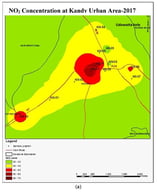
Urban Park vegetation plays a crucial role in mitigating air pollution by serving as a natural sink for gaseous and particulate pollutants, thereby enhancing the ecological sustainability of cities. Identifying tree species with high tolerance to air pollution is therefore essential for effective urban park planning and management in highly polluted urban environments. This study evaluated the air pollution tolerance of selected tree species commonly found in urban parks of Kandy City, Sri Lanka, using the Air Pollution Tolerance Index (APTI). Five tree species—Terminalia catappa (Indian almond), Cassia fistula (golden shower tree), Pongamia pinnata (Indian beech), Madhuca longifolia (butter tree), and Tabebuia rosea (pink poui)—were assessed at two urban park locations representing contrasting pollution levels, identified based on ambient SO2, NO2, and PM2.5 concentrations. APTI was calculated using four leaf biochemical parameters: pH, ascorbic acid content, relative water content, and total chlorophyll content. Leaf samples were collected from ten replicates of each species at both sites. Madhuca longifolia exhibited the highest APTI values (17.06 at the HP site and 25.17 at the LP site), followed by Cassia fistula, Terminalia catappa, Tabebuia rosea, and Pongamia pinnata. These findings suggest that the identified species, particularly Madhuca longifolia and Cassia fistula, are well-suited for urban greening and can contribute to mitigating air pollution impacts. However, these findings are constrained by a single cross-sectional sampling term, limited species screening, sequential data collection variances, and fixed mathematical equations. Consequently, future research should implement continuous multi-station monitoring arrays, expand species diversity, establish localized biochemical weightings, and initiate long-term multi-seasonal tracking to resolve temporal dynamics in tropical urban ecosystems.

18 June 2026

(a) NO2 concentration map of Kandy Urban Area, (b) SO2 concentration map of Kandy Urban Area, (c) Portable Air Quality Monitoring Device (DM72B, Dienmern, Shenzhen, China).

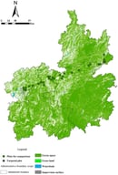
The switch in land use of abandoned tailings can precondition their reuse as newly built parks. This study investigated the feasibility of reusing a remediated mercury (Hg) retorting site in Wanshan, Guizhou Province, China, as a functional urban park by assessing residual heavy metal risks and associated vegetation responses. Field investigations were conducted across 31 park sites distributed along an east–west geographical gradient from the former mining area to urban parks, using replicated plots to sample the surface soils and dominant plant species. The concentrations of arsenic (As), cadmium (Cd), mercury (Hg), manganese (Mn), and lead (Pb) in soil and plant tissues were quantified using inductively coupled plasma–mass spectrometry, and vegetation structure and diversity were evaluated using standard community indices. The results showed significant spatial variability in soil and plant metal concentrations, with higher levels generally observed near historically impacted areas of the mine. However, all soil metal concentrations were below the national safety thresholds. Plant tissues exhibit controlled metal accumulation within normal or regulated ranges, reflecting the effective screening of tolerant and hyperaccumulating species. Increasing heavy metal concentrations were associated with reduced vegetation coverage, height, and diversity along the gradient. Overall, the findings indicate that the reclaimed Hg retorting site almost met ecological safety requirements, but more data on deep soils, groundwater, and long-term observations are needed to draw more conclusive conclusions.

10 June 2026

The study area and sampling plots were distributed along an east–west gradient from the eastern tailings to western Guiyang city.

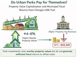
Investments in urban parks are frequently justified not only in terms of their environmental and recreational amenities but also in terms of their potential to fuel appreciation in neighborhoods and corresponding increases in local fiscal revenues. There is a substantial body of literature indicating that proximity to parks and other forms of urban open spaces can be capitalized into surrounding residential property values; however, there is relatively limited research examining whether these effects plausibly translate into fiscal revenues that could offset the costs of urban park projects. This study seeks to address this question in the context of Chicago’s 606 Trail, a 2.7-mile elevated rail-to-trail conversion completed and opened on 6 June 2015, after a publicly disclosed investment of $95 million in the project at the time of opening. Using property transaction data and a difference-in-differences event-study approach, this study estimates the impact of park completion on surrounding residential property values and converts these amenity capitalization effects into corresponding municipal fiscal revenues. The main contribution of this paper is to demonstrate that amenity capitalization and fiscal self-financing are analytically separate outcomes, even though park completion may be associated with corresponding increases in surrounding residential property values. The study contributes a framework for evaluating substantial urban park investments by drawing on both urban amenity studies and municipal finance studies.

16 April 2026

Event-study estimates of the 606 trail’s capitalization effect on residential assessed values, by distance band. Each panel plots DiD coefficients relative to the omitted reference year (2014, k = −1), with 95% confidence intervals. Upper left: 0–250 m; upper right: 250–500 m; lower left: 500–1000 m; lower right: 1000–2000 m (control).

News & Conferences

Volumes

Latest Issues

Open for Submission

Editor's Choice

XFacebookLinkedIn
J. Parks - ISSN 3042-5689