

Recent Advances in Geospatial Data Management and Analytics
A special issue of Applied Sciences (ISSN 2076-3417). This special issue belongs to the section "Earth Sciences".
Deadline for manuscript submissions: 20 July 2026 | Viewed by 117
Special Issue Editors

Interests: GIS; digital terrain modelling; remote sensing

Interests: GIS; precision agriculture; multicriteria analysis; farming and cropping systems; inventory of natural resources ords 3
Special Issues, Collections and Topics in MDPI journals

Interests: urban geography; spatial data modeling; quality of life
Special Issues, Collections and Topics in MDPI journals
Special Issue Information
Dear Colleagues,
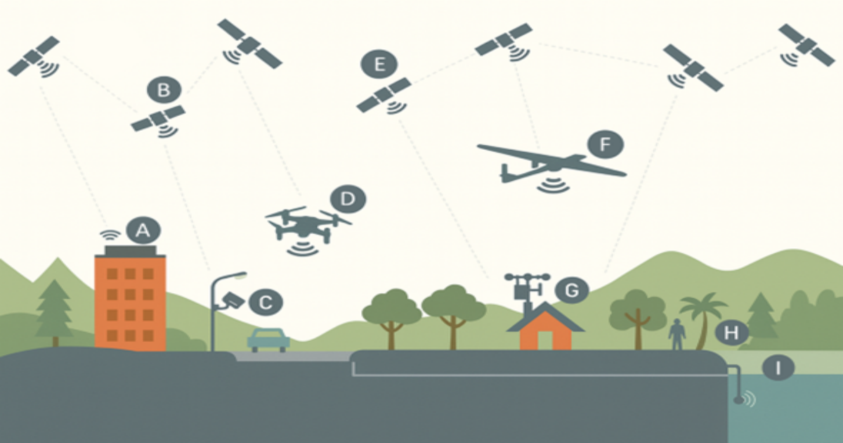
In recent years, geospatial science has experienced pronounced development driven by advances in remote sensing, unmanned aerial systems, LiDAR technologies, radar measurements, and increasingly dense networks of in situ sensors. These developments have substantially expanded both the volume and diversity of available spatial data, opening new avenues for observing environmental and urban systems at high spatial and temporal resolutions. At the same time, progress in geospatial artificial intelligence (GeoAI), machine learning, multimodal data integration, and cloud-based computation has strengthened the analytical capacity of the field, enabling more sophisticated modelling of natural processes and human–environment interactions.
Despite this progress, the integration and interpretation of heterogeneous geospatial datasets remain major challenges. Differences in spatial scale, sensor characteristics, temporal frequency, and semantic structure complicate the development of unified analytical frameworks, while domain shift continues to limit the transferability of predictive algorithms. The lack of benchmark datasets and standardized validation protocols further restricts reproducibility, particularly in research related to climate change, natural hazards, environmental degradation, water-resource management, and complex urban systems.
This Special Issue brings together contributions that directly address these challenges and propose conceptually and methodologically advanced solutions. The collected papers span varied topics, such as GeoAI and machine-learning approaches, multimodal data fusion, real-time geospatial big-data management, ecological and geomorphological modelling, hydrological risk analysis, and urban analytics.
Recent trends particularly highlight the growing importance of multisensory approaches, which enable more comprehensive observation of environmental and urban processes, ranging from geomorphological change and coastal dynamics to ecosystem conditions, flood-risk assessment, and applications in precision agriculture. The integration of UAV photogrammetry, LiDAR, multispectral and hyperspectral imagery, radar-based water-level measurements, GNSS observations, and field data supports the development of detailed terrain and surface-process models, thereby increasing the reliability of simulations and the effectiveness of early-warning systems. Building on these sensing frameworks, multimodal AI models integrate heterogeneous data sources within unified analytical structures, enabling deeper interpretation of climate-induced changes and the development of more robust predictive analyses.
By presenting these interconnected perspectives, this Special Issue will highlight the most recent advances in geospatial data management and analytics and promote the development of robust, scalable, and transparent methodologies essential for addressing environmental and societal challenges in the decades ahead.
Prof. Dr. Ante Šiljeg
Prof. Dr. Mladen Jurišić
Dr. Silvija Šiljeg
Guest Editors
Manuscript Submission Information
Manuscripts should be submitted online at www.mdpi.com by registering and logging in to this website. Once you are registered, click here to go to the submission form. Manuscripts can be submitted until the deadline. All submissions that pass pre-check are peer-reviewed. Accepted papers will be published continuously in the journal (as soon as accepted) and will be listed together on the special issue website. Research articles, review articles as well as short communications are invited. For planned papers, a title and short abstract (about 250 words) can be sent to the Editorial Office for assessment.
Submitted manuscripts should not have been published previously, nor be under consideration for publication elsewhere (except conference proceedings papers). All manuscripts are thoroughly refereed through a single-blind peer-review process. A guide for authors and other relevant information for submission of manuscripts is available on the Instructions for Authors page. Applied Sciences is an international peer-reviewed open access semimonthly journal published by MDPI.
Please visit the Instructions for Authors page before submitting a manuscript. The Article Processing Charge (APC) for publication in this open access journal is 2400 CHF (Swiss Francs). Submitted papers should be well formatted and use good English. Authors may use MDPI's English editing service prior to publication or during author revisions.
Keywords
- geospatial data management
- multimodal data integration
- geospatial artificial intelligence (GeoAI)
- remote sensing
- UAV photogrammetry
- LiDAR
- flood risk modelling
- urban analytics
Benefits of Publishing in a Special Issue
- Ease of navigation: Grouping papers by topic helps scholars navigate broad scope journals more efficiently.
- Greater discoverability: Special Issues support the reach and impact of scientific research. Articles in Special Issues are more discoverable and cited more frequently.
- Expansion of research network: Special Issues facilitate connections among authors, fostering scientific collaborations.
- External promotion: Articles in Special Issues are often promoted through the journal's social media, increasing their visibility.
- Reprint: MDPI Books provides the opportunity to republish successful Special Issues in book format, both online and in print.
Further information on MDPI's Special Issue policies can be found here.