


Abstract
Numerous landslides occurred in the region of Atsuma (Hokkaido, Japan) as a result of the 2018 Hokkaido Eastern Iburi Earthquake. Despite their devastating consequences, the emergence of mass movements has provided a unique opportunity to gain insight into specific chapters of Earth’s history by exposing new natural outcrops and revealing rock strata, including the Middle Miocene Kawabata Formation. The formation primarily comprises sedimentary rocks that reflect various deep-sea environments, especially the continental slope and basin plain of a foreland basin. For this reason, an exposed bedding plane consisting of polygonal features, recently (September 2022) discovered in an outcrop formed at the scarp of a landslide, has aroused interest. Mud cracks or desiccation marks often form in the tidal zone due to exposure to the subaerial environment but not in the aforementioned deep-sea facies. An additional series of evidence of subaerial exposure, with potential wet and dry cycles in a near-shore/coastal environment, was revealed, such as limonite grain coatings and hypocoatings, as well as biotite exfoliation. Based on this evidence, a putative new Middle Miocene facies and a potential new stratigraphic member was proposed in the Kawabata Formation.
1. Introduction
To understand the importance of the findings (potential desiccation marks, or mud cracks) exposed on a randomly discovered bedding plane surface in a Miocene sediment sequence, it is crucial to briefly summarize the evolution of Hokkaido, the northernmost of the main islands of Japan.
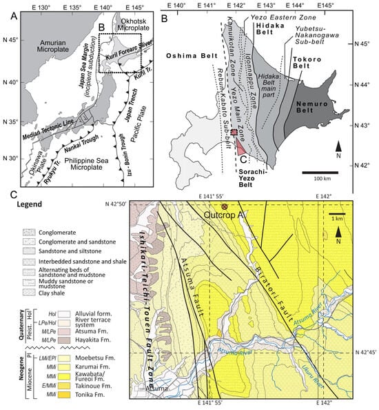
In present-day plate tectonic settings, Hokkaido Island lies on the North American plate (specifically the Okhotsk plate) and faces the Eurasian plate (Amur plate) (Figure 1A). This tectonic setting, consisting of a plate boundary running at the eastern margin of the Sea of Japan, became active from the Quaternary period onward. However, prior to reaching the present-day plate tectonic setting, the complex structural, geological, and paleoenvironmental evolution of the region should be introduced.
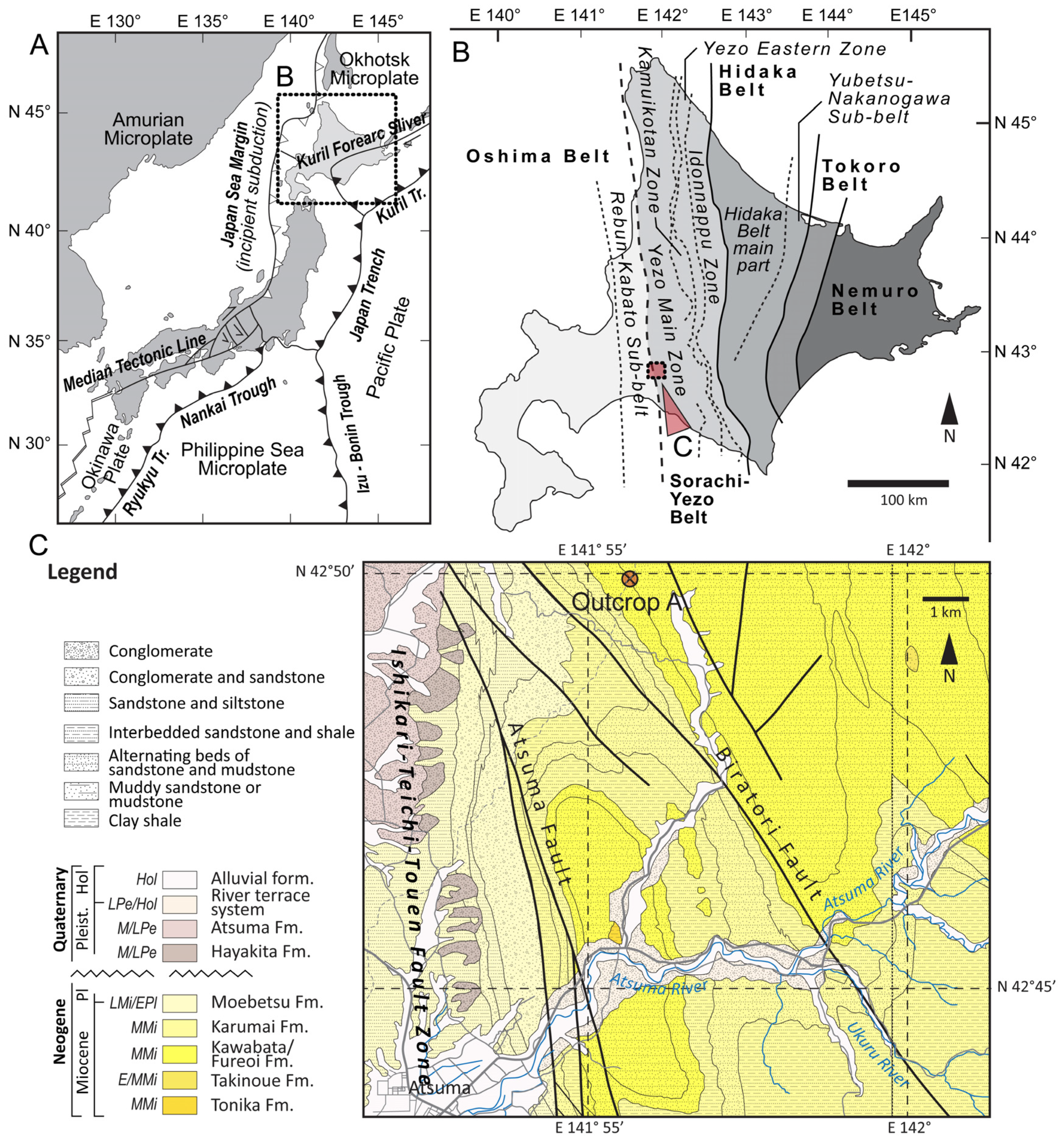
Figure 1.
Main tectonic units and boundaries around the Japanese archipelago (A), the tectonic units and tectonostratigraphic zonation of Hokkaido (B), and the geology in the neighborhood of the studied profile (Outcrop A) (C). The figures are based on the studies by Iwasaki et al. [1], Taira [2], and Takahashi et al. [3], as well as the GeomapNavi database [4]. In the abbreviation of the geochronological units, E, M, and L stand for early, middle, and late, respectively; abbreviations such as Mi, Pl, Pe, and Hol represent Miocene, Pliocene, Pleistocene, and Holocene units.
The oldest pre-Neogene basement formations in the region date back to the Late Paleozoic (Carboniferous and Permian) and belong to the Oshima belt, one of the region’s tectonostratigraphic belts. The Oshima belt is part of the mainly north–south-aligned belt system in the region, consisting of the Oshima, Sorachi–Yezo, Hidaka, Tokoro, and Nemuro belts, forming a complex accretionary system with progressively younger structural geological units eastward (Jurassic, Cretaceous, and Paleogene accretionary complexes). The Oshima and Sorachi–Yezo belts belong to the Honshu (NE Japan) arch–trench system, while the latter two, the Tokoro and Nemuro belts, are attributed to the Kuril arc. The Hidaka belt stands “in between”, with parts connecting to the Honshu arch–trench system, and others to the Kuril arc [5,6]. Such a setting defines the tectonic division of Hokkaido Island, namely the so-called Honshu and Kuril terranes [5,6] (Figure 1A,B).
The initial pre-Neogene plate tectonic setting changed during the Miocene when the major tectonic boundary moved through present-day Central Hokkaido, resulting in the formation of a collision zone between the Kuril and Honshu (NE Japan) arcs, accompanied by tectonic processes, such as the rotation of Eastern Hokkaido; a fold-and-thrust belt formation in Central Hokkaido, along with thrust faults; and dextral share zones that triggered the metamorphism and exhumation of various blocks (e.g., foreland basin deposits and Miocene granulites) [5].
Considering the main sedimentary facies types, the frontal parts of the collision zone comprise a foreland sedimentary basin or foredeep. The sediments of the basin can be found incorporated, e.g., in the fold-and-thrust belt of Central Hokkaido. The sediments of the foredeep, dating from the Late Oligocene (Erimo Fm.) to the Pliocene (e.g., Moebetsu Fm. and Nibudani Fm.), and the Miocene formations (e.g., Kawabata Fm. and Karumai Fm.) are mainly characterized by deep-sea sediments, especially various turbidite-related types (e.g., sheet-flow and slope-apron turbidites), and are fed by uplift and extensive erosion in the region [5,6,7,8,9,10,11,12] (Figure 1C).
As was suggested above, the Miocene formations mainly consist of turbidites, and for this reason, finding polygonal features, namely desiccation marks (mud cracks), which generally appear in near-shore or coastal environments (e.g., tidal facies, delta plains, coastal flats, and so on) indicates subaerial exposure in deep-sea sediments (whether they are deep sea or not) and has thus raised attention (Figure 2).
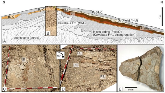
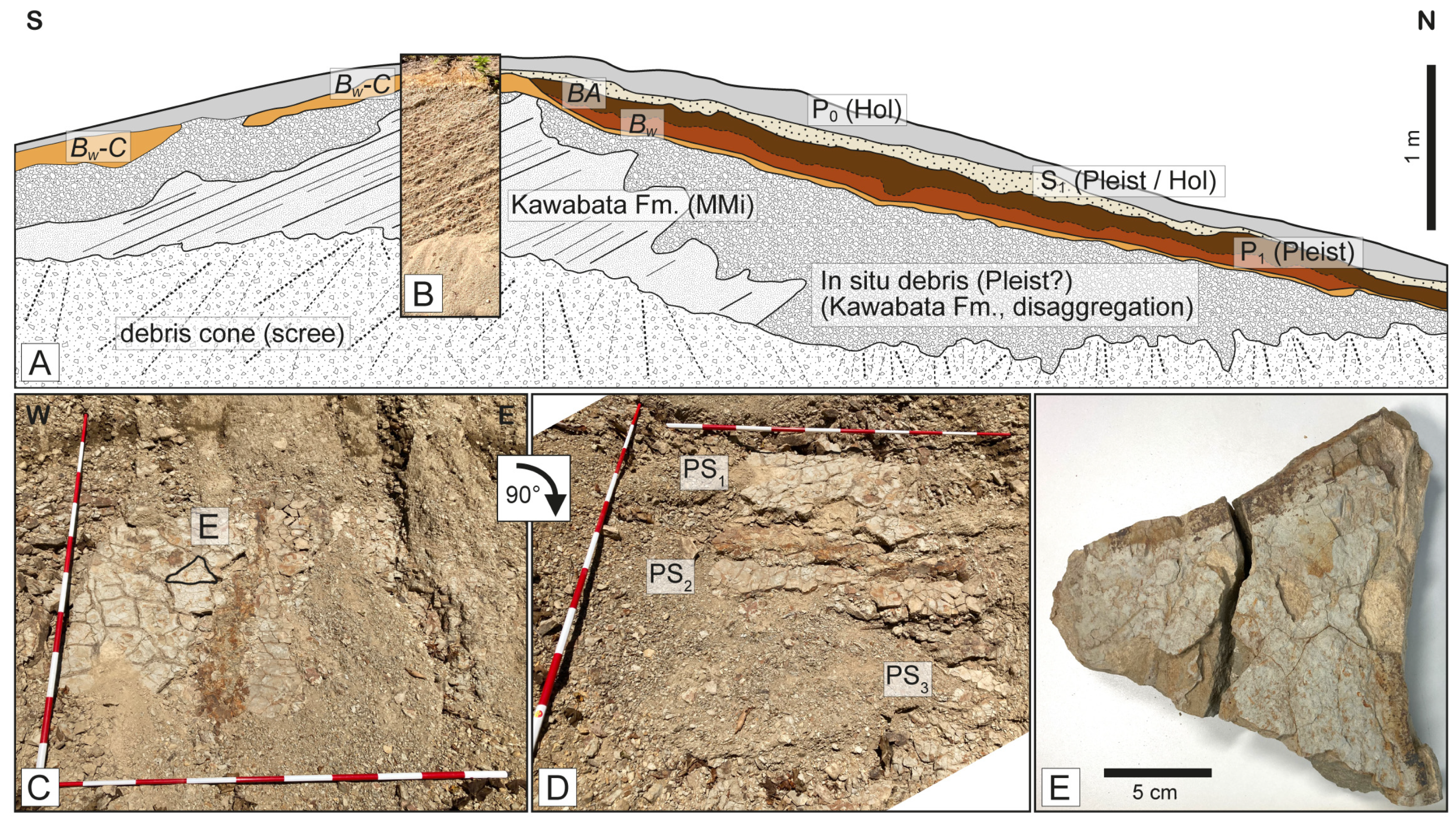
Figure 2.
Regular appearance of Kawabata Fm. in the neighborhood of the studied outcrop. Schematic cross-section with putative chronostratigraphy of the appearing units (A), with a field image of the layers (B). The bedding plane of consolidated sediments consisting of polygonal structures (mud cracks or desiccation cracks) is exposed by the scarp of a landslide (C). The exposed bedding surface consists of the potential polygonal surface (PS1, PS2, and PS3), with generations revealed by a field study (D), and the polygonal unit taken for further laboratory analysis (E). Abbreviations: P0—recent soil, P1—(Late) Pleistocene (Pleist) cambisol-like paleosol, S1—Pleistocene (Pleist)/Holocene (Hol) sediment unit, BA—transitional soil horizon, Bw—weathered subsoil layer, Bw-C—transition horizon between Bw and C, and MMi—Middle Miocene. The red and white sections in the scale indicate 10 cm (C,D).
The goal of this study is to introduce the recently (September 2022) discovered polygonal features, present preliminary results from scanning electron microscopy, and discuss the importance of this finding for the future reconstruction of Miocene sedimentary environments that appeared around the Japanese archipelago.
2. Site and Sampling
The sampled profile is located near Atsuma city (Hokkaido, Japan), southeast of the Mizuho Dam, at coordinates 42.83206° N, 141.92766° E (Figure 1, Outcrop A). Among the Miocene sediments, Kawabata Fm. (also called Fureoi Fm.) is among the most commonly appearing ones, indicating two characteristic facies possibly related to submarine fan, continental slope, and the deep-sea foreland basin environments: (i) channel levee facies and (ii) sheet-flow turbidite [12]. The former (channel levee) facies comprise thick sandstone units, and the alternation of mudstone members and sandstone horizons represents the Tc zone of a Bouma sequence. The latter (sheet-flow turbidite) facies consist of sand and mudstone members in rhythmic alternation [12].
Near the studied profile, several outcrops, mainly roadcuts, have appeared, consisting of the Kawabata Fm. (Figure 2A,B). The profiles exposed along the roadcuts in the neighborhood of the sampled site uniformly show a 40–45° S dip angle with a strike of 90° E (azimuth). The entire profile consists of consolidated sediments, with alternating layers of sand and mudstone, while the upper section of the Kawabata Fm. (Middle Miocene) often consists of disaggregated (physically weathered), debris-like units with barely visible stratification, all covered by a discordant cambisol-like paleosol (P1) horizon with recognizable AB, Bw, and C pedogenic sub-horizons. Depending on the paleotopographical position, the paleosol, or some of its sub-horizons, may be eroded or covered by loose sediments (S1) and the recent P0 topsoil (Figure 2A). The extensively weathered parts, the buried paleosol horizon, and the loose sediments may represent surface processes that appeared during cold and dry glacial (physical weathering and terrestrial clastic sedimentation) and more humid and mild interglacial periods (pedogenesis) of the (Late) Pleistocene and the Holocene.
The studied and sampled profile has been exposed by a landslide, located at the landslide head or main scarp. Despite its poor condition (i.e., partly covered by debris), the mass movement, with its slide surface quasi-parallel to the dipping bedding plane of the sediment units of the Kawabata Fm., exposed at least three generations of polygonal features (potential mud cracks or desiccation marks) (Figure 2C,D). In other words, the dipping plane of the Kawabata Fm. provided a perfect slip or shear surface for the landslide mass/debris, helping expose the polygonal layers by removing the overlying layers during the mass movement.
The size of the irregular-shaped polygons ranged between ~10 and 20 cm in diameter, with no characteristic orientation or alignment shown. The depth of the cracks between polygonal blocks was approximately 3 and 4 cm, and no sediment fills could be observed (Figure 2C–E). No downward narrowing was observed within the cracks either.
Polygonal features are common in various environments, e.g., in near-shore and coastal facies, where subaerial exposure and repeated wetting and drying can occur. Finding such features in a sediment sequence originally defined as turbidite/deep-sea facies may indicate additional facies/paleoenvironment information about the Middle Miocene in the region and point toward a potential redefinition of the main characteristics of the units of Kawabata Fm. [13,14,15]. A further field study has revealed additional polygonal surfaces lying below the initially discovered bedding plane (Figure 2D). The appearance of generations of polygonal structures suggests that such “subaerial exposure events” might appear periodically. The red limonite coloring observed in the field may suggest longer subaerial exposure, weathering, regolith formation, and even early pedogenesis. The periodically appearing polygonal surfaces were covered by sediment units that were unaffected by cracks and polygonal network formation, suggesting that all subaerial events occurred subsequently in the Middle Miocene rather than during a much later polygon-forming event, e.g., in the Pleistocene.
These assumptions led us to sample the paleosurface and collect a polygonal block for further laboratory study (Figure 2E).
As shown in Figure 2, the subsurface layers, namely a paleosol horizon and clastic unconsolidated sediment units, connect with an angular unconformity to the in situ (physically) weathered debris of Kawabata Fm. These sediments and paleosol layers most likely developed during the colder and drier glacial/stadial (debris and loose sediments) and more humid and warmer interglacial/interstadial periods (paleosol horizon) of the Pleistocene.
3. Methods
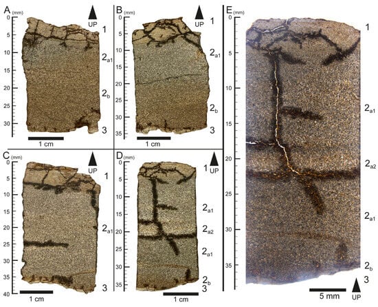
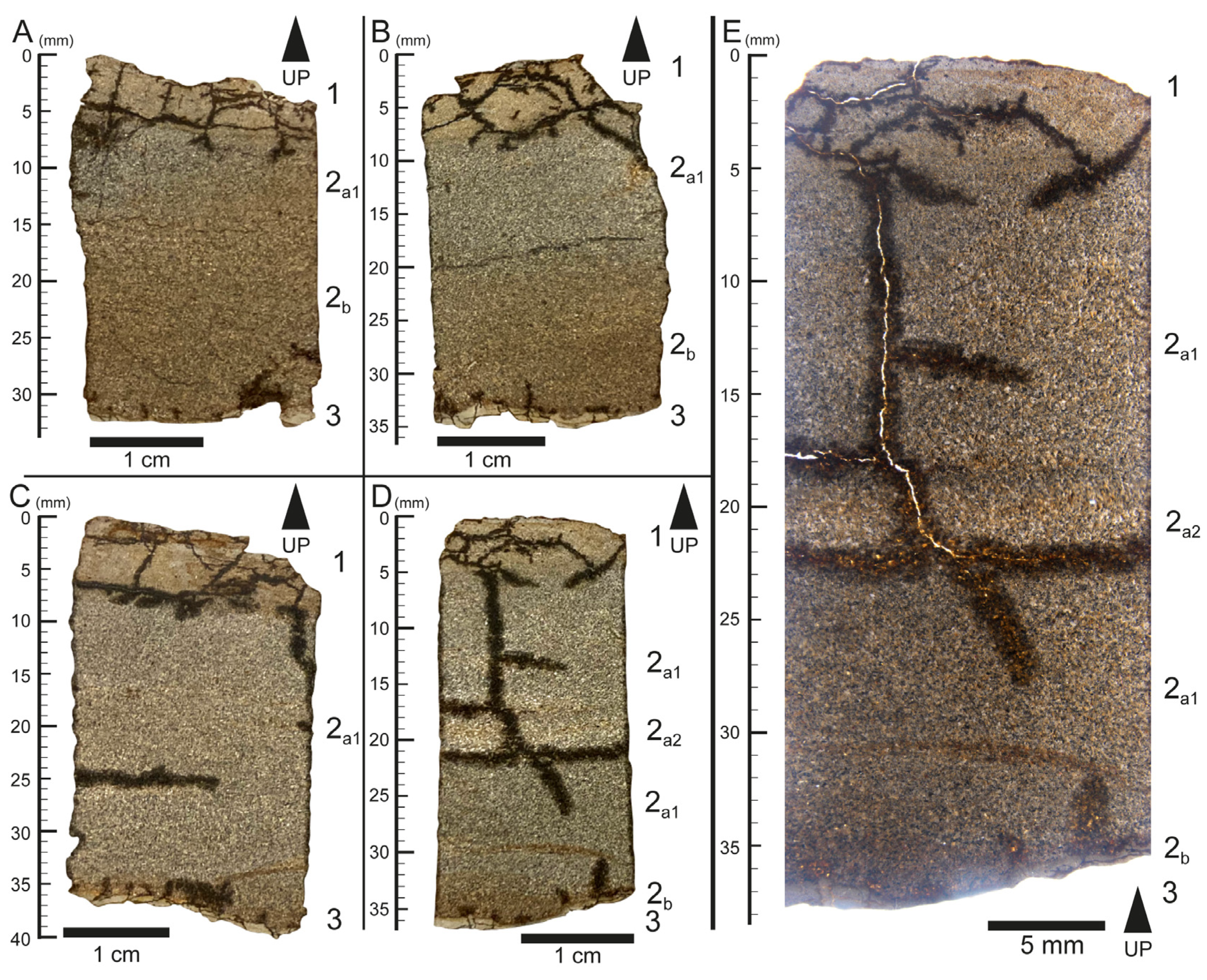
Four vertically oriented thin sections were prepared from the polygonal block taken from the field (Figure 2E and Figure 3A–D) for preliminary analysis.
Figure 3.
Vertically oriented thin sections prepared for binocular microscopy and SEM analysis (A–D), and a higher-resolution binocular microscopic image of the thin section introduced in Figure 3D (E). Please note that during the preliminary studies, the thin sections were not polished to the standard 30 µm, as SEM analysis does not require such a thickness.
During the general description and (surface) mesomorphological study of the specimens (which examines features between microscopic and macroscopic scales), a stereomicroscope (Kenis, Osaka, Japan) equipped with a Raku-01 microscope camera (Kenis, Osaka, Japan) was used.
Subsequently, the carbon-coated samples with a well-polished surface were studied using a JEOL JSM-6480LAII scanning electron microscope (SEM) (JEOL Co, Tokyo, Japan) equipped with an energy-dispersive X-ray spectroscope (EDS) (JEOL Co, Tokyo, Japan) for chemical analyses at the Department of Planetology, Kobe University (Japan). EDS measurements were obtained at 15 kV and 0.4 nA, with a working distance of 10 mm. The collection time for the spectra was 100 s. Data corrections were made using the ZAF method routine, embedded in the software package of Analysis Station 3.91 developed by JEOL Co. (Tokyo, Japan), with well-established natural/synthesized materials distributed by JEOL Co. (Tokyo, Japan) as chemical standards.
4. Results
4.1. Mesomorphology—Binocular Microscopy
The mesomorphological description of the sampled section revealed microstratification in the studied samples, comprising five characteristic layers (named 1, 2a1, 2a2, 2b, and 3).
The uppermost microlayer (Layer 1; Figure 3) is a ~5 mm thick fine-grained, light (grayish) orange–yellow (Munsell color; wet: 7.5YR6/6, and dry: 10YR8/6) silty clay horizon, a possible remnant of a mudstone member with alternating mudstone–sandstone layers. A network of smaller cracks is visible in this unit.
The underlying 2.5–3 cm thick layer (Layer 2; Figure 3) is a coarser sandy unit, representing the sandstone member of the characteristic sandstone–mudrock heterolithic sequence. Based on its physical characteristics (color and texture), it can be separated into upper gray (2a1 and 2a2; Figure 3) and lower (reddish) brown–light brown (wet: 7.5YR4/3 and dry: 7.5YR6/3) sandstone units (2b; Figure 3). The upper gray microunit (2a) can be separated further into two subsections: an upper ~1 cm thick, middle gray unit (wet: 10YR5/1 and dry: 2.5Y6-7/1; 2a1; Figure 3) and a lower, thinner (~0.5 cm), lighter colored one (wet: 10YR6/1, and dry: 2.5Y8/1; 2a2; Figure 3D). This subunit only appeared in one thin section (Figure 3D), which may suggest it is a phenomenon that appears scattered throughout the sediment (e.g., lenticular bedding). Layers 2a1 and 2a2 can form micro laminae that build up the 2a unit.
The underlying unit is a red (wet: 7.5YR4/3, and dry: 7.5YR6/3), sandy microlayer that connects to the 2a unit with a gradual boundary (Layer 2b; Figure 3A,B,D).
The lowermost unit only appears as millimeter-thick fragments, consisting of a fine, light-colored (wet: 10YR8/3, and dry: 10YR8/1) silty clay unit (Layer 3; Figure 3).
There are two types of commonly appearing mesomorphological features in the studied thin sections: (i) a network of quasi-horizontal and vertical cracks and (ii) the appearance of various limonite (goethite) precipitation features.
The formation of the former, i.e., the network of horizontal and vertical cracks, seems to be strongly related to material differences and sedimentary structure/boundaries observed in the studied thin sections. A few longer cracks appear in the lower, coarser sediment section of the samples, with the horizontal ones seemingly following the boundaries between various sedimentary microunits (Figure 3D,E). The uppermost finer sediment unit of the sample consists of a well-developed network of shorter, finer cracks, connecting the top of the underlying coarser sediment to the supposed polygonal paleosurface (Figure 3).
The latter, i.e., the limonite precipitation features, appears in various forms, such as colorings (Figure 3A,B,D, 2b subunit), precipitation fronts (Figure 3C–E), and hypocoatings along the cracks (Figure 3).
Microlamination with sub-millimeter-thick laminae might also appear in some thin sections, e.g., in the thin section A (Figure 3A, between 15 and 20 mm depth). Such a feature is unique among the studied samples.
A characteristic vertically and horizontally oriented network of cracks can be observed in all the studied samples, especially in the samples shown in Figure 3D,E, where the network crosses the full microlayer structure.
4.2. Scanning Electron Microscopy and Energy-Dispersive X-Ray Spectroscopy
Along with the basic description of the samples, the preliminary SEM and EDS studies primarily focused on observing index minerals and features that may indicate changes in the sedimentary environment related to the development of the polygonal structure.
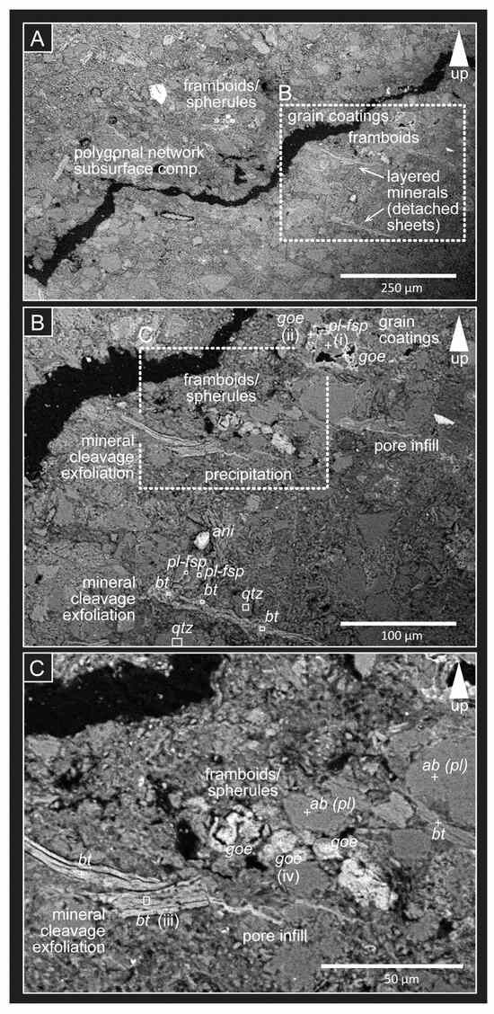
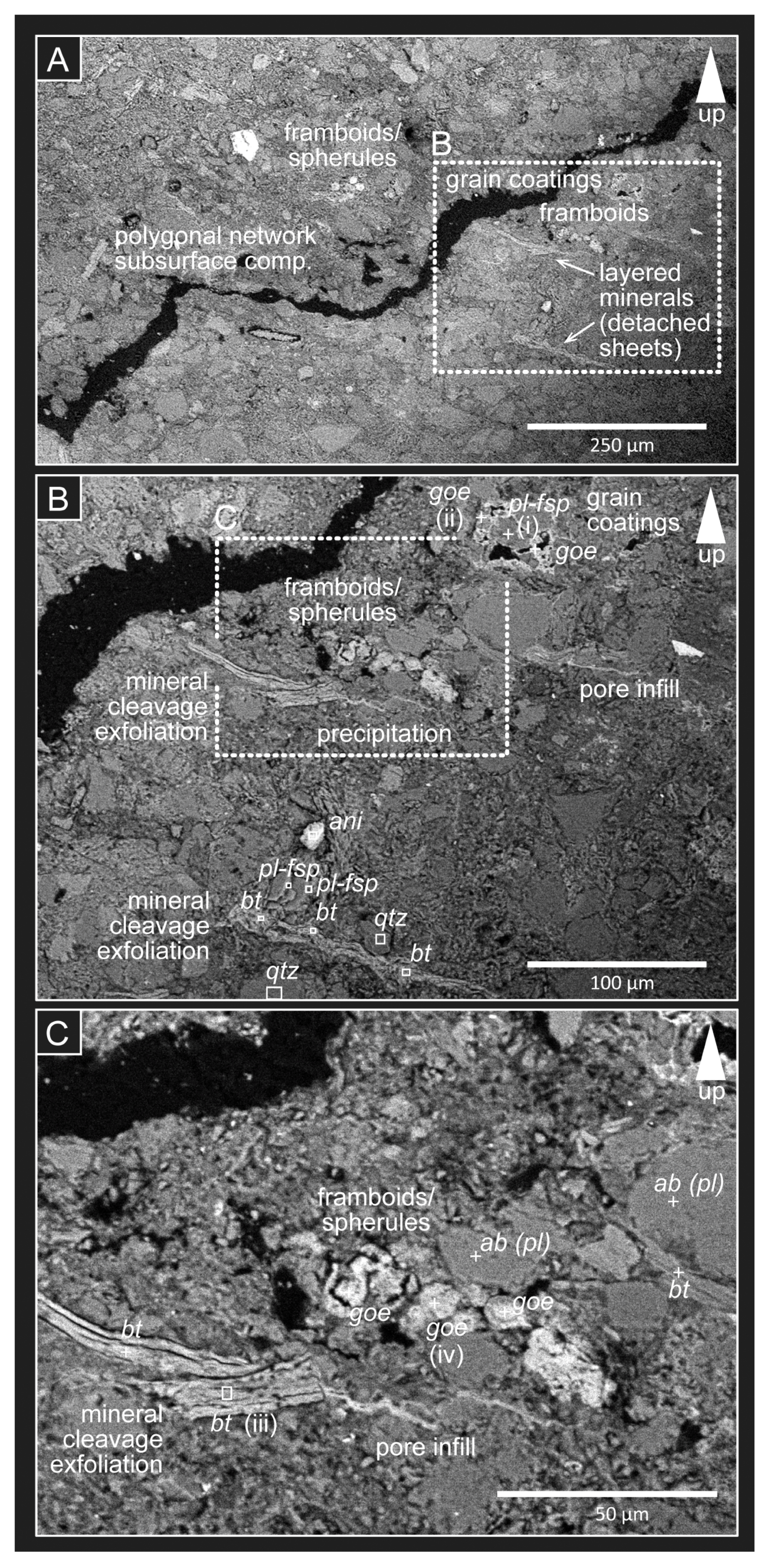
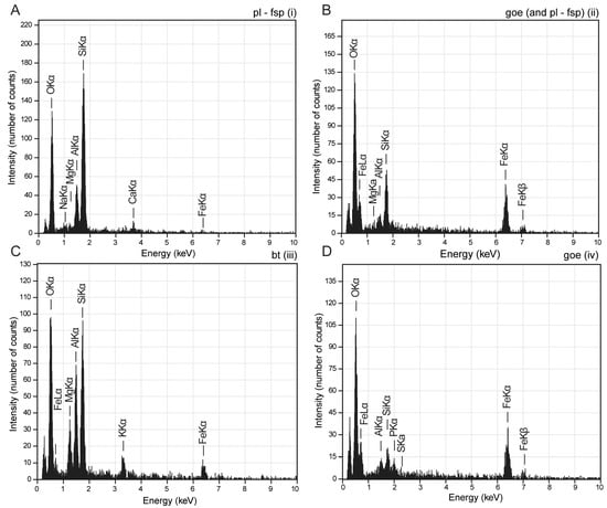
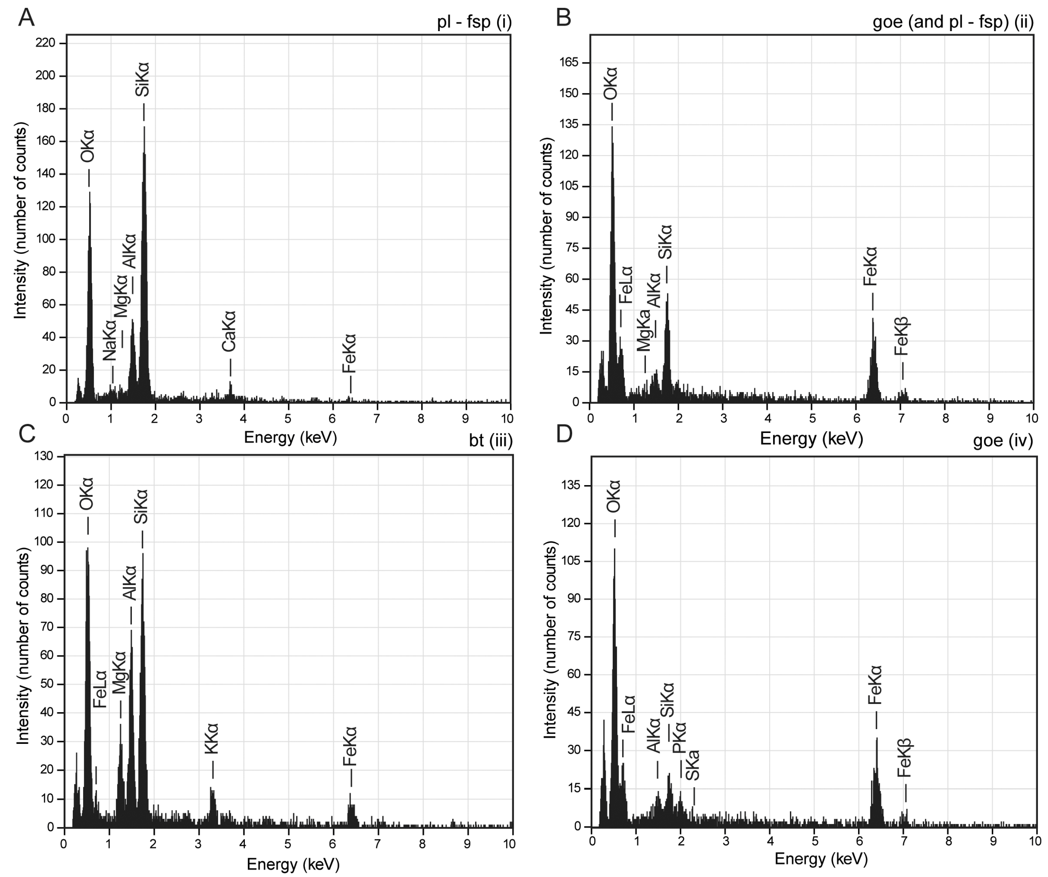
The most common minerals observed in the studied location are quartz, plagioclase feldspar (e.g., albite), biotite, and goethite (limonite) (Figure 4 and Figure 5).
Figure 4.
Micrograph of various features observed in the pilot sample of the preliminary SEM study (backscattered electron images). The images show increasing-magnification views of the general structure of a polygon vertical cross section (A). The chosen location contains various features indicating mineral alteration, weathering, and subaerial exposure (B), including mineral cleavage exfoliation and framboids/spherules (C). For detailed information please see the text. Abbreviations: ab—albite, bt—biotite, fsp—feldspar, goe—goethite (limonite), pl—plagioclase, and qtz—quartz. The images also include the putative interpretation of various features, such as mineral cleavage exfoliation, pore infill, grain coatings, polygonal network subsurface comp., and framboids/spherules. Detailed information is provided in the Discussion Section.
Figure 5.
EDS spectra of some of the observed minerals (mineral association) in the micrograph marked by i, ii, iii, and iv, as introduced in Figure 4: plagioclase feldspar grain (A), goethite (limonite) grain coating with plagioclase (B), biotite grain (C), and goethite (limonite) pseudomorph of pyrite framboids/goethite spherules (D). Abbreviations: bt—biotite, fsp—feldspar, goe—goethite (limonite), and pl—plagioclase. (Elemental distribution data are available upon request.).
The roundness of the observed (quartz) grains varies between sub-angular and very angular, with various sphericity (Figure 4).
Regarding secondary mineral formation, the SEM micrographs support the observations of limonite’s appearance. Goethite (limonite) grain coatings appeared commonly in the petrofabric (Figure 4 and Figure 5A,B), along with pore and crack infills (Figure 4).
Considering mineral alteration processes, exfoliation of the mineral cleavage and deformation of the sheets was observed in almost all the biotite fragments found in the samples (Figure 4 and Figure 5C).
Features resembling pyrite framboids appeared as well (Figure 4B,C); however, based on the EDS analysis, they turned out to be goethite/limonite pseudomorphs of pyrite after considering their chemical composition (Figure 5D). The concentric (weathering) structure and detachment of the outer and inner sections were also recognized inside the putative framboids (Figure 4A,B).
5. Discussion
5.1. Indicators of Various Facies and Environment Components
The alternating sandstone and mudrock units observed and characterized during the mesomorphological examination (Figure 3) are identified as characteristic sediments of the deep-sea, sheet-flow turbidite members of the Kawabata Fm [7,8,11,12]. These alternating layers appear almost uniformly in the outcrop shown in Figure 2A, in the in situ layers with polygonal surfaces exposed by mass movement (Figure 2B,C), and in many other profiles in the region.
Polygonal structures. The identification of the polygonal structures as putative mud cracks or desiccation marks observed in the field, which are primary indicators of exposure to a subaerial environment, may be supported by various microscopic features that provide further information on changes in the sedimentary environment.
Please note that several processes may contribute to the formation of polygonal features [16,17,18]: volcanic cooling, periglacial thermal contraction, desiccation contraction, mechanical jointing, and sheet jointing. Among these, volcanic cooling can undoubtedly be excluded considering the sedimentary nature of the studied rocks.
Mechanical jointing and sheet jointing (as well as any tectonic-process-related polygon formation). Such processes may result from exposure to changing stress fields, producing parallel fracture systems from different directions. The networks of various fracture systems can create a polygon-like pattern. The ten-centimeter polygon sizes and shallow crack depths are more characteristic of desiccation or mud cracks [19] and do not support theories of polygon-like fracture formation on a regional tectonic scale. In addition, the studied section and surrounding outcrops show uniform strikes and dips, indicating a uniform stress field rather than a changing stress field or a system with stress fields oriented in multiple directions, which allows us to exclude tectonic processes as the main cause of polygon formation.
Permafrost/periglacial-process-related polygon formation. Given the supposed (deep-sea) environment of sedimentation and diagenesis, as well as the formation time (Middle Miocene), permafrost and periglacial processes can be excluded. As post-sedimentary alterations, these may be listed if the layers were exposed to a Pleistocene environment and were not consolidated enough to prevent alteration triggered by various processes occurring in a periglacial environment. Along with the lack of other permafrost features in the profile (e.g., cryoturbation, sediment wedges, and so on), the Miocene sections in the neighborhood showed well-preserved layers, similar to those containing polygonal features that were covered by debris related to the very recent landslide. For this reason, we believe that the exposed layers represent the original, non-eroded sedimentary section. The surrounding laminae show no deformation along the cracks, a characteristic feature of permafrost polygonal features, which also supports a non-permafrost/periglacial origin for the features of the Kawabata Fm.
Pedogenic processes. Various pedogenic processes can also produce polygonal features. Such features often appear in (paleo) soils, some consisting of various pedogenic horizons, some with significant fine-grained content (clay), or some material capable of volume change in various ways (e.g., mineral growth). The studied material shows no evidence of pedogenesis or the development of pedogenic structures and horizons [20] For this reason, we also excluded pedogenic processes from the formation of the polygonal features.
Microscopic network of cracks. The network of quasi-vertical and horizontal cracks observed at the meso- and microscopic levels indicates that both the fine-grained upper and coarser lower sandy units were influenced by subaerial exposure and desiccation processes (Figure 3 and Figure 4). The development of a horizontal (micro-scale) crack system, following (or along) the development of the main vertical network, is characteristic of, e.g., systems with wetting–drying cycles. Differences in crack micromorphology may indicate differences in shrinkage potential, i.e., in the case of the Kawabata Fm. sedimentary units, differences in the material of the layers [20,21] (Blokhuis et al. 1990; Yin et al. 2022).
Goethite/limonite. The high variety of goethite (limonite) appearance and its meso- and micromorphology, including colorings, precipitation fronts (bands), grain coatings, hypocoatings, and infills (pores and fractures) (Figure 3 and Figure 4), indicate an oxidative environment with a migration of iron-(super)saturated solutions that follow the pore structure and crack network toward the surface. This migration and oxidative environment might have developed due to periodic or permanent subaerial exposure and intensified evaporation (i.e., redox fluctuation—wetting and drying phases) [22]. In summary, the appearance of hypocoatings and dissolution fronts indicates increasing evaporation and upward migration rather than the downward movement of some solutions. This agrees with the formation environment of desiccation marks. Please note that at this stage of research, it is difficult to clearly define the formation of the limonite features, but given the repeating nature of the polygonal surfaces with similar characteristics, they may have formed along the polygonal network instead of during a much later post-sedimentation/polygon-formation period (e.g., Quaternary and modern times). Grain coatings may also have functioned as cementation during diagenesis of the sediment layers.
Biotite. The observed biotite grains show the initial phase of weathering, characterized by hydration, delamination, and exfoliation of the biotite sheets, which often occur during wet–dry sedimentary or pedogenic cycles in a subaerial environment (Figure 4) [23], although these are less characteristic, e.g., of deep-sea facies.
Goethite/limonite pseudomorph of pyrite framboids. Authigenic pyrite formation is common in anoxic sedimentary environments, such as deep-sea facies, as represented by the Kawabata Fm., and produces various mineral morphologies [24], including pyrite framboids, which reflect an early stage of anoxic diagenesis [25]. This anoxic environment changed as the sediment sequence evolved, altering pyrite to goethite in a more oxidative environment—for example, near-shore and/or coastal facies.
Goethite spherules. Given the internal structure of the putative framboids observed through SEM (Figure 4C), the formation of goethite spherules may be a possible alternative to the pyrite alteration hypothesis introduced above. The formation of these spherules may also be explained by surface (wave and current agitation—e.g., goethite ooids) and subsurface (goethite concretions) processes; that is, mixing reduced, iron-rich, and oxygenated water induces chemical precipitation from supersaturated (warm) water (concretion formation), while mechanical (rolling) accretion helps goethite ooid formation in a shallow marine environment [26]. During this process, apatite may also be adsorbed (chemical processes on the goethite ooid’s surface—ligand exchange [27]). This would also explain the appearance of phosphate in the EDS plot (Figure 5D).
Please note that the mechanical accretion and development of concretions are just a few among many processes that may result in the formation of goethite spherules (e.g., [26]), but the detailed observation of the ooids/spherules appearing in the studied sequence is out of the focus of this preliminary study.
5.2. Implications of the Polygonal Structure Discovery
All preliminary findings point to sedimentary facies in which wet and dry periods repeatedly formed the paleoenvironment, with cycles of water-covered and subaerial exposure phases. Such sedimentary environments may occur in fluvial facies (e.g., alluvial plains), delta facies (e.g., delta plains), coastal facies (e.g., coastal marshes), and tidal flats [28].
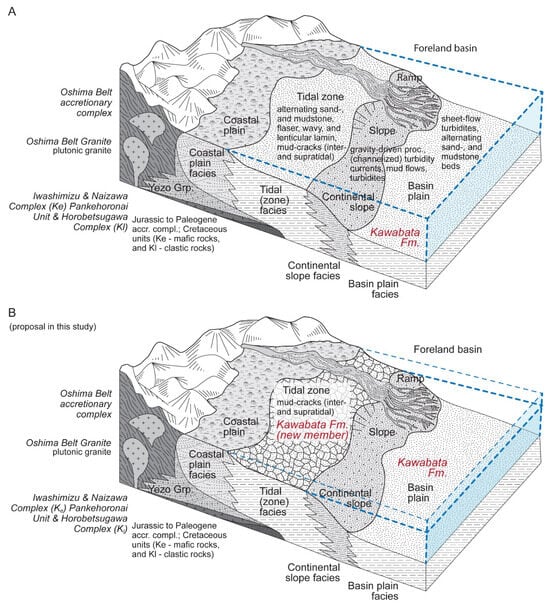
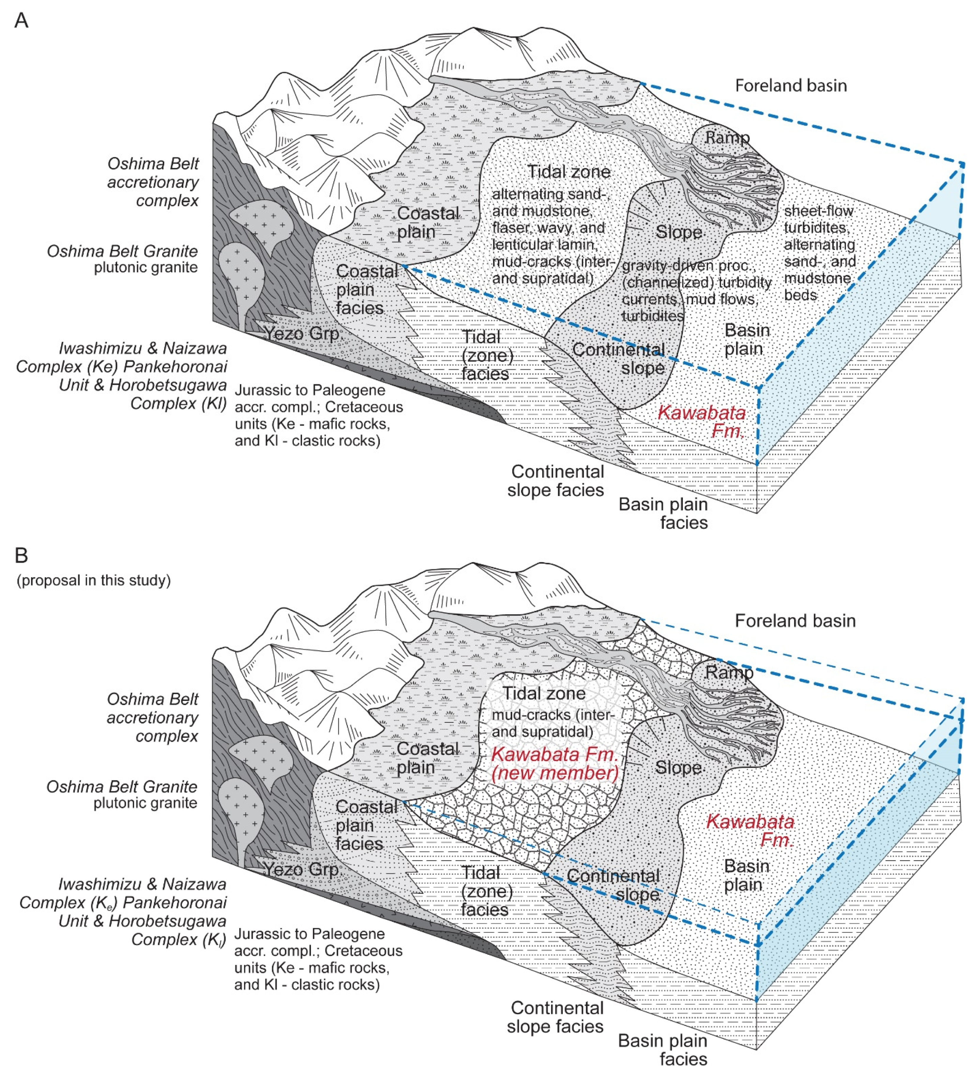
The indicators of a near-shore/coastal facies seem to contradict common knowledge about the Kawabata Formation, namely that the formation represents a deep-sea foreland basin environment (even reaching a depth of 1000 m [7,8]) characterized by sheet-flow turbidites (Figure 6). In addition, the observation of a series of polygonal paleosurfaces (PS1, PS2, and PS3; Figure 2D) suggests that the subaerial exposure was not a singular event but a repeated series of events during the Middle Miocene.
Figure 6.
The possible implication of the recently (September 2022) discovered polygonal structures—a hypothesis about a new member of Kawabata Fm. (A,B) Combined general facies characteristics with a known formation from the studied region in Hokkaido. The generally accepted facies and sedimentary paleoenvironment reconstruction, which identifies the Kawabata Fm. as a sheet-flow turbidite deposited in Basin Plain, is depicted in Figure 6A [5,6,12]. The proposed new member of the Kawabata Fm., following the very recent discovery of the polygonal structures (mud cracks) is described in Figure 6B. Please note that (Figure 6A,B) both provide information on the similarities and differences between the general facies characteristics of the various paleoenvironments potentially present in a Middle Miocene coastal–near-shore–deep-sea generalized facies complex around Hokkaido; however, in the initial description of the Kawabata Fm. (Figure 6A), the existence of the polygonal features/mud cracks in these sections was unknown.
6. Conclusions
We may ask whether we need to re-evaluate the commonly accepted view about the Kawabata Formation, i.e., whether it represents channel levee and sheet-flow turbidite facies that developed in a deep-sea environment [7,8,11,12]. Confusion might occur between some sections of alternating sandstone and mudstone layers of the sheet-flow turbidites, as well as the alternating sand- and mudstone layers of, e.g., tidal sediments, when the studied facies types do not carry many of the key diagnostic features of turbidites or when features are not clearly recognizable (e.g., due to the condition of the studied outcrops or the lack of exposure of the depositional/sedimentation bed).
Along with the observed indicators of subaerial exposure and near-shore or coastal paleoenvironment, additional evidence from the literature may support our findings. Plant fragment-rich horizons have been observed and were interpreted to be the result of long-distance transportation from a terrestrial environment through density flows and deposition in a deep-sea environment [29]. The existence of a recently discovered facies type in Kawabata Fm. may provide an alternative explanation, suggesting that the deposition of plants happened in, e.g., a shore or near-shore environment (e.g., a lagoon), instead of a deep-sea environment following a series of re-depositions (which may have prevented the development of tens of centimeter/meter-thick fossil plant-rich layers), as was suggested by a previous study [29]. Unfortunately, without reinvestigation of the profiles that consist of plant fossil-rich layers, this is merely speculation and far from being clear evidence.
Despite the series of evidence indicating subaerial exposure, it may be possible that the whole Kawabata Fm. (especially the Amagiri Sandstone and Mudstone Member; [8]) needs to be reinterpreted; however, without clear and additional evidence, only a proposal for a new facies and a new potential lithostratigraphic member can be introduced in this study. This new member of the Kawabata Fm. must be taken into account in, e.g., future geological mapping and Miocene paleoenvironment reconstructions from the Hokkaido region (Figure 6).
Author Contributions
Conceptualization, B.B.; methodology, B.B.; formal analysis, B.B., C.G. and T.K.; investigation, B.B. and R.N.; writing—original draft preparation, B.B.; writing—review and editing, B.B. and C.G.; visualization, B.B. All authors have read and agreed to the published version of the manuscript.
Funding
This research received no external funding.
Data Availability Statement
Research data are available upon request from the corresponding author.
Acknowledgments
We thank the anonymous reviewer for their constructive comments.
Conflicts of Interest
The authors declare no conflicts of interest.
Abbreviations
The following abbreviations are used in this manuscript:
| SEM | Scanning electron microscope |
| EDS | Energy-dispersive X-ray spectroscope |
| Fm. | Formation (as a stratigraphic unit) |
| EMi | Early Miocene |
| E/MMi | Early/Middle Miocene |
| MMi | Middle Miocene |
| LMi/EPl | Late Miocene/Early Pliocene |
| M/LPe | Middle/Late Pleistocene |
| LPe/Hol | Late Pleistocene/Holocene |
| Hol | Holocene |
| PS1, PS2, PS3 | Polygonal surface (generations 1 to 3) |
| P0 | Recent (surface) soil |
| P1 | Pleistocene (cambisol-like) paleosol |
| S1 | Pleistocene/Holocene sediment unit |
| BA | Transitional soil horizon |
| Bw | Weathered subsoil layer |
| Bw-C | Transition horizon between Bw and C (parent material of soil) |
| ab | Albite |
| ani | Anilite |
| bt | Biotite |
| fsp | Feldspar |
| goe | Goethite |
| pl | Plagioclase |
| qtz | Quartz |
References
- Iwasaki, T.; Ozel, O.; Moriya, T.; Sakai, S.I.; Suzuki, S.; Aoki, G.; Maeda, T.; Iidaka, T. Lateral structural variation across a collision zone in central Hokkaido, Japan, as revealed by wide-angle seismic experiments. Geophys. J. Int. 1998, 132, 435–457. [Google Scholar] [CrossRef] [Scilit]
- Taira, A. Tectonic evolution of the Japanese island arc system. Annu. Rev. Earth Planet. Sci. 2001, 29, 109–134. [Google Scholar] [CrossRef] [Scilit]
- Takahashi, Y.; Shimura, T.; Kato, S. Plutonic and metamorphic rocks in the southern Hidaka metamorphic belt, Hokkaido. J. Geol. Soc. Jpn. 2018, 124, 399–411. [Google Scholar] [CrossRef] [Scilit]
- GeomapNavi, Geological Survey of Japan & AIST (National Institute of Advanced Industrial Science and Technology). GeomapNavi (Geological Map Display System). Available online: https://gbank.gsj.jp/geonavi/geonavi.php#6,38.247,137.000 (accessed on 11 March 2026).
- Ueda, H. Hokkaido. In The Geology of Japan; Moreno, T., Wallis, S., Kojima, T., Gibbons, W., Eds.; The Geological Society: London, UK, 2016; pp. 201–221. [Google Scholar]
- Ueda, H. Accretion and exhumation structures formed by deeply subducted seamounts in the Kamuikotan high-pressure/temperature zone, Hokkaido, Japan. Tectonics 2005, 24, TC2007. [Google Scholar] [CrossRef] [Scilit]
- Kawakami, G.; Yoshida, K.; Usuki, T. Preliminary study for the Middle Miocene Kawabata Formation, Hobetsu district, central Hokkaido, Japan; special reference to the sedimentary system and the provenance. J. Geol. Soc. Jpn. 1999, 105, 673–686, (In Japanese with English abstract). [Google Scholar] [CrossRef] [Scilit]
- Kawakami, G.; Shiono, M.; Kawamura, M.; Urabe, A.; Koizumi, I. Stratigraphy and depositional age of the Miocene Kawabata Formation, Yubari Mountains, central Hokkaido, Japan. J. Geol. Soc. Jpn. 2002, 108, 186–200, (In Japanese with English abstract). [Google Scholar] [CrossRef] [Scilit]
- Kawakami, G.; Arita, K.; Okada, T.; Itaya, T. Early exhumation of the collisional orogen and concurrent infill of foredeep basins in the Miocene Eurasian–Okhotsk Plate boundary, central Hokkaido, Japan: Inferences from K–Ar dating of granitoid clasts. Isl. Arc 2004, 13, 359–369. [Google Scholar] [CrossRef] [Scilit]
- Kawakami, G.; Ohira, H.; Arita, K.; Itaya, T.; Kawamura, M. Uplift history of the Hidaka Mountains, Hokkaido, Japan: A thermochronologic view. J. Geol. Soc. Jpn. 2006, 112, 684–698. [Google Scholar] [CrossRef] [Scilit]
- Kawakami, G. Foreland basins at the Miocene arc-arc junction, central Hokkaido, northern Japan. In Mechanism of Sedimentary Basin Formation-Multidisciplinary Approach on Active Plate Margins; Itoh, Y., Ed.; InTech: London, UK, 2013; pp. 131–152. [Google Scholar] [CrossRef] [Scilit]
- Itoh, Y.; Tamaki, M.; Takano, O. Rock Magnetic Properties of Sedimentary Rocks in Central Hokkaido—Insights into Sedimentary and Tectonic Processes on an Active Margin. In Mechanism of Sedimentary Basin Formation: Multidisciplinary Approach on Active Plate Margins; Itoh, Y., Ed.; InTech: London, UK, 2013; pp. 233–253. [Google Scholar] [CrossRef] [Scilit]
- Plummer, P.S.; Gostin, V.A. Shrinkage cracks; desiccation or synaeresis? J. Sediment. Res. 1981, 51, 1147–1156. [Google Scholar] [CrossRef] [Scilit]
- Goehring, L.; Conroy, R.; Akhter, A.; Clegg, W.J.; Routh, A.F. Evolution of mud-crack patterns during repeated drying cycles. Soft Matter 2010, 6, 3562–3567. [Google Scholar] [CrossRef] [Scilit]
- Zhao, Z.; Guo, Y.; Wang, Y.; Liu, H.; Zhang, Q. Growth patterns and dynamics of mud cracks at different diagenetic stages and its geological significance. Int. J. Sediment Res. 2014, 29, 82–98. [Google Scholar] [CrossRef] [Scilit]
- Krantz, W.B. Self-organization manifest as patterned ground in recurrently frozen soils. Earth-Sci. Rev. 1990, 29, 117–130. [Google Scholar] [CrossRef] [Scilit]
- Berman, D.A.; Mellon, M.T. Morphometrics of polygonal ground on Earth and Mars: Assessing formation mechanisms from orbit. Icarus 2025, 435, 116558. [Google Scholar] [CrossRef] [Scilit]
- Shur, Y.; Jones, B.M.; Jorgenson, M.T.; Kanevskiy, M.Z.; Liljedahl, A.; Walker, D.A.; Ward Jones, M.K.; Fortier, D.; Vasiliev, A. Formation of low-centered ice-wedge polygons and their orthogonal systems: A review. Geosciences 2025, 15, 249. [Google Scholar] [CrossRef] [Scilit]
- Nichols, G. Sedimentology and Stratigraphy; Wiley-Blackwell: Hoboken, NJ, USA, 2009; 419p. [Google Scholar]
- Blokhuis, W.A.; Kooistra, M.J.; Wilding, L.P. Micromorphology of cracking clayey soils (Vertisols). In Developments in Soil Science; Elsevier: Amsterdam, The Netherlands, 1990; Volume 19, pp. 123–148. [Google Scholar] [CrossRef] [Scilit]
- Yin, P.; Vanapalli, S.K.; Yu, S. Morphological characteristics of desiccation-induced cracks in cohesive soils: A critical review. Bull. Eng. Geol. Environ. 2022, 81, 503. [Google Scholar] [CrossRef] [Scilit]
- Stoops, G.; Marcelino, V.; Mees, F. (Eds.) Interpretation of Micromorphological Features of Soils and Regoliths; Elsevier: Amsterdam, The Netherlands, 2018; 720p. [Google Scholar]
- Fitzpatrick, E.A. Properties of minerals in thin sections. In Micromorphology of Soils; Springer: Dordrecht, The Netherlands, 1984; pp. 66–101. [Google Scholar] [CrossRef] [Scilit]
- Chang, J.; Li, Y.; Lu, H. The Morphological Characteristics of Authigenic Pyrite Formed in Marine Sediments. J. Mar. Sci. Eng. 2022, 10, 1533. [Google Scholar] [CrossRef] [Scilit]
- Wilkin, R.T.; Barnes, H.L.; Brantley, S.L. The size distribution of framboidal pyrite in modern sediments: An indicator of redox conditions. Geochim. Cosmochim. Acta 1996, 60, 3897–3912. [Google Scholar] [CrossRef] [Scilit]
- Kearsley, A.T. Iron-rich ooids, their mineralogy and microfabric: Clues to their origin and evolution. Geol. Soc. Lond. Spec. Publ. 1989, 46, 141–164. [Google Scholar] [CrossRef] [Scilit]
- Gehring, A.U. The formation of goethitic ooids in condensed Jurassic deposits in northern Switzerland. Geol. Soc. Lond. Spec. Publ. 1989, 46, 133–139. [Google Scholar] [CrossRef] [Scilit]
- Reading, H.G. (Ed.) Sedimentary Environments: Processes, Facies and Stratigraphy; John Wiley & Sons: Hoboken, NJ, USA, 2009; 669p. [Google Scholar]
- Furota, S.; Sawada, K.; Kawakami, G. Depositional processes of plant fragment-concentrated sandstones in turbiditic sequences recorded by plant biomarkers (Miocene Kawabata Formation, Japan). Int. J. Coal Geol. 2021, 233, 103643. [Google Scholar] [CrossRef] [Scilit]
Disclaimer/Publisher’s Note: The statements, opinions and data contained in all publications are solely those of the individual author(s) and contributor(s) and not of MDPI and/or the editor(s). MDPI and/or the editor(s) disclaim responsibility for any injury to people or property resulting from any ideas, methods, instructions or products referred to in the content. |
© 2026 by the authors. Licensee MDPI, Basel, Switzerland. This article is an open access article distributed under the terms and conditions of the Creative Commons Attribution (CC BY) license.