


Abstract
With the increasing demand for perception in complex road environments in intelligent driving, rapid and accurate identification of paved-road obstacles has become a critical prerequisite for driving safety and comfort. Various types of road obstacles can significantly affect vehicle stability and ride quality. To address this challenge, a lightweight and efficient vision-based obstacle detection framework, termed GroupScale-YOLO, is proposed, in which detection accuracy and computational efficiency are jointly enhanced through the collaborative design of multiple novel modules. First, a dedicated dataset targeting common paved-road obstacles is constructed, and six data augmentation strategies are employed to mitigate the adverse effects of road surface undulations and illumination variations on visual perception. Second, to overcome the limitations of YOLOv11n in paved-road obstacle detection tasks, targeted optimizations are introduced to the backbone network, convolutional blocks, and detection head. Experimental results indicate that GroupScale-YOLO achieves a 29.95% reduction in model parameters while simultaneously increasing mAP@0.5 by 0.6% on the self-built dataset, demonstrating its suitability for deployment in resource-constrained scenarios. Furthermore, real-vehicle road tests confirm that the proposed method maintains stable and accurate obstacle detection performance under practical driving conditions, offering a reliable solution for intelligent vehicle environmental perception.
1. Introduction
As autonomous driving and intelligent transportation systems continue to advance, object detection has emerged as a core enabling technology, with an increasing demand for real-time and efficient detection frameworks [1]. As an important factor affecting driving safety, ride comfort, and vehicle energy efficiency, the capability to perceive road surface obstacles has attracted growing research attention in intelligent driving applications.
During actual driving on paved roads, potholes may cause damage to vehicle suspension systems, while the presence of speed bumps requires vehicles to decelerate in advance. Variations in manhole cover height can adversely affect tire grip, and lightweight road debris such as plastic bottles may induce instantaneous tire skidding when crushed at high speed. In response to these road surface conditions, two major research directions have gradually emerged in perception system development. The first direction focuses on LiDAR-based perception systems, which detect the surrounding environment by emitting laser beams to acquire high-precision three-dimensional spatial information [2]. The second direction emphasizes pure vision-based perception systems, which rely on cameras to capture image data and utilize computer vision algorithms to analyze and recognize road surface obstacles and road condition information. However, due to the high cost of LiDAR sensors, large-scale deployment in commercial vehicles remains challenging. Consequently, vision-based technologies, owing to their cost-effectiveness and ease of integration, have become one of the most promising solutions for road surface obstacle detection [3].
Existing detection networks generally suffer from large parameter scales, high computational complexity, and limited suitability for embedded deployment. Achieving model lightweighting while maintaining detection accuracy has thus become a key challenge in current research. To address these challenges, extensive studies have been conducted on two-stage detectors, Transformer-based frameworks, and YOLO-series real-time detection networks [4]. Guofa Li et al. [5] integrated atrous spatial pyramid pooling (ASPP) into CenterNet by reconstructing the backbone and introducing space-to-depth modules, enhancing feature representation while preserving a lightweight architecture. Yan Zhou et al. [6] incorporated deformable convolution and spatial attention modules within Faster R-CNN, proposing AD-Faster R-CNN to improve small-object feature extraction through refinement of the feature pyramid structure. Huaqi Zhao et al. [7] designed a position-sensitive attention mechanism and a group axial attention Transformer encoder based on DETR, improving multi-scale object detection performance while reducing inference computation. However, two-stage and Transformer-based approaches generally exhibit complex structures and high inference latency, making them less suitable for real-time deployment in on-board vehicle systems.
YOLO-based methods, characterized by an end-to-end detection paradigm and high inference efficiency, are widely used in autonomous driving perception tasks. Yan Zhou et al. [8] proposed MobileYOLO, which adopts MobileNetV2 as the backbone and introduces an SSH context module in the small-object detection branch, enhancing detection performance while reducing parameter scale. Lingzhi Xu et al. [9] optimized the hyperparameter search of YOLOv5 by integrating an improved Grey Wolf Optimizer with the Whale Optimization Algorithm, thereby improving model stability and global search capability. Minhong Jin et al. [10] proposed AVD-YOLO, which incorporates an active vision-driven multi-scale feature strategy together with position-adjusted attention, improving robustness under complex lighting and weather conditions, albeit at the cost of increased computational overhead. In recent years, research focus has gradually shifted toward lightweight YOLO variants for embedded deployment. Jie Cao et al. [11] introduced the SPD-CBS downsampling module and a lightweight DyHead stacking structure based on YOLOv8n, achieving improved accuracy while maintaining high frame rates, albeit with an increase in parameter count to 1.66 times that of the original model. Liye Jiang et al. [12] integrated a defogging module (DHMD) into YOLOv8 to enhance robustness under adverse weather conditions, but introduced additional computational overhead. H. Ren et al. [13] incorporated coordinate attention into the SPPF module of YOLOv8 to strengthen positional information during feature fusion; however, the relatively large model size still constrains deployment on in-vehicle embedded platforms.
With the introduction of YOLOv11, researchers have begun exploring lightweight and scenario-adaptive improvements. Peng Ji et al. [14] proposed SDOS-YOLO, which adopts an SC-HGNetv2-based backbone together with LSKA attention and the RepGFPN fusion strategy, resulting in a notable reduction in parameter scale while simultaneously improving detection performance. Enqiang Liang et al. [15] constructed C3CTA and DFPN structures based on YOLOv11 by integrating spatial–frequency attention and channel transposition attention mechanisms, achieving excellent detection performance under complex road conditions such as occlusion and small-object scenarios with only 2.51 M parameters, demonstrating strong real-time performance and embedded deployment potential. However, most existing studies primarily focus on vehicle–road coordination or general object detection scenarios and have not been specifically optimized for sudden road elevation change detection in autonomous driving applications. Further improvements are still needed in terms of scenario specificity, structural lightweighting, and coordination with height measurement tasks.
Herein, this study constructs a dedicated dataset encompassing four types of typical road surface obstacles and proposes a lightweight road surface information detection framework, termed GroupScale-YOLO. To clearly delineate the core contributions and technical boundaries of this work, the proposed approach is explicitly divided into two aspects: methodological innovations and system-level integration optimizations. The methodological innovations primarily consist of two newly designed modules, namely C3k2-GMSC (Grouped Multi-Scale Convolution) and C3k2-GMSB (Grouped Multi-Scale Block). By performing structured group-wise multi-scale feature modeling and channel-wise feature reorganization, these modules enhance the representation of scale-aware and geometrically consistent features, which are particularly relevant for structured road scenes. In contrast, the system-level integration optimizations focus on improving deployment efficiency rather than introducing new modeling concepts. Specifically, a lightweight HGNetV2 backbone, depthwise separable convolutions (DWConv), and Detect-DSB (Dynamic Shared-BN Detect) are incorporated to reduce parameter redundancy and computational cost, thereby facilitating embedded deployment.
Owing to the above designs, GroupScale-YOLO demonstrates strong overall performance in terms of accuracy, compactness, and deployment efficiency, fulfilling the requirements of practical vehicle-mounted applications.
2. System Design
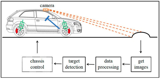
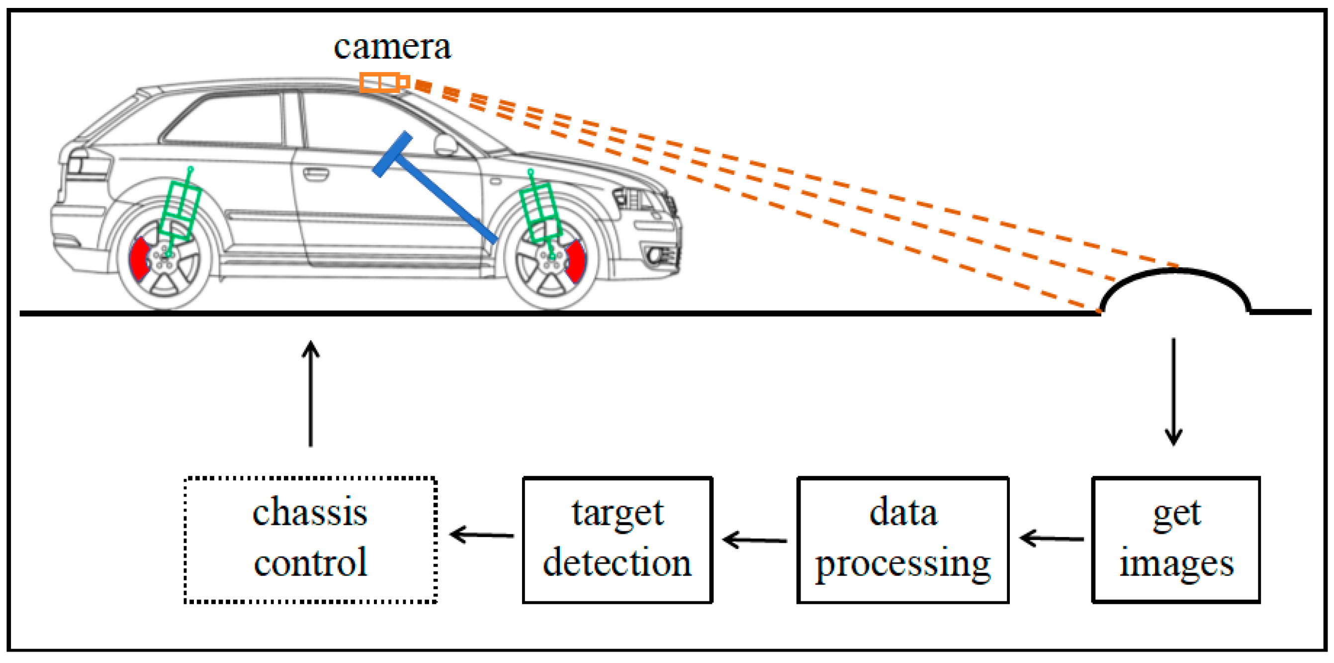
This study presents a road obstacle preview system for intelligent vehicles, as illustrated in Figure 1.
Figure 1.
Overview of the proposed road obstacle preview framework.
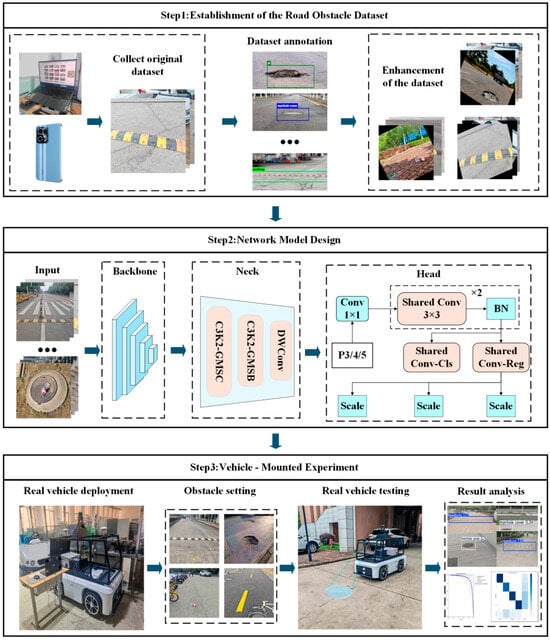
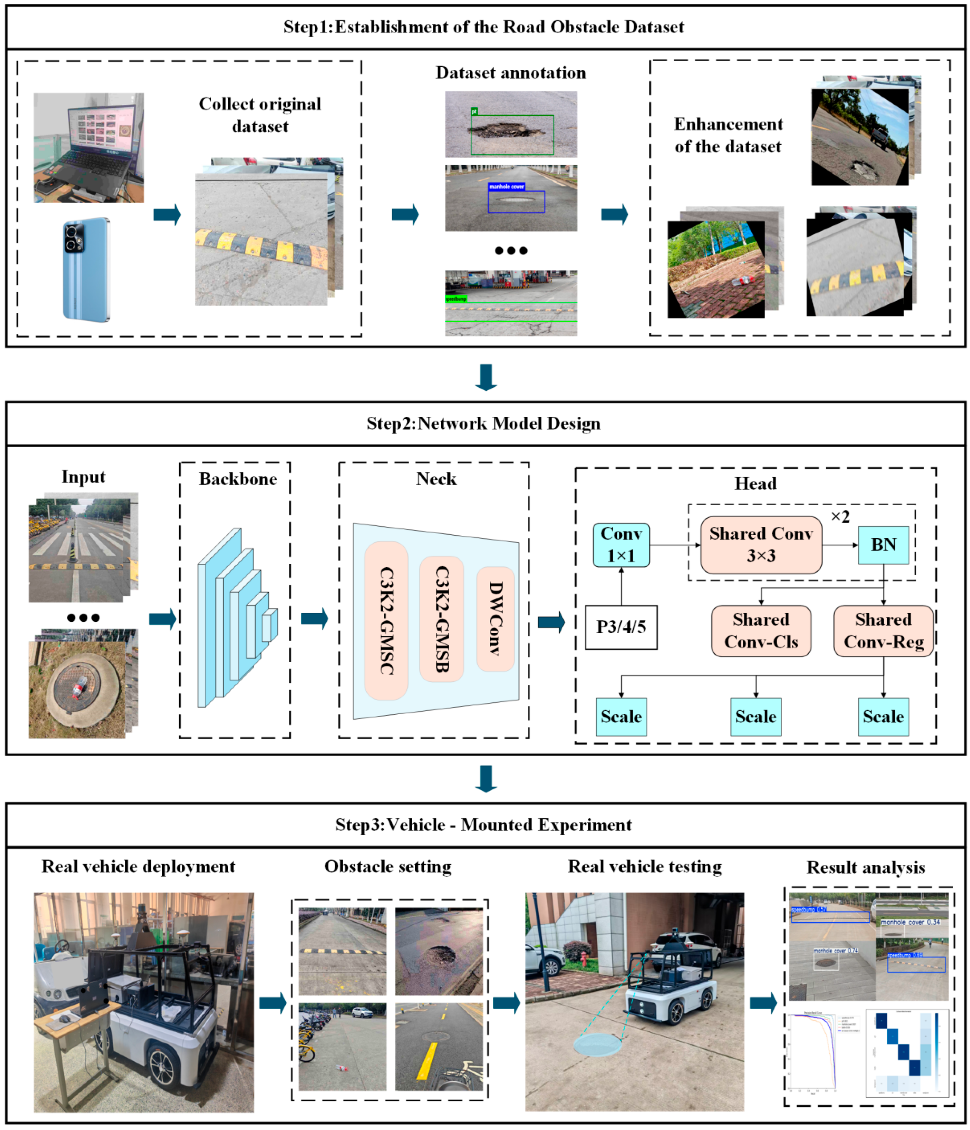
The proposed framework employs a roof-mounted camera to detect road surface obstacles and integrates deep learning with machine vision techniques to perform data processing and target detection, thereby providing preview information for subsequent chassis control systems [16]. The overall structure of the road obstacle preview system is shown in Figure 2.
Figure 2.
Framework of road obstacle preview system.
The proposed research framework consists of three core modules. (1) Dataset establishment module: Image data are collected through two primary approaches, including on-site acquisition using a handheld camera on paved roads such as national highways and campus roads, as well as supplementary data collected from the Internet. The constructed dataset covers several typical road surface obstacles, including potholes, speed bumps, manhole covers, and plastic bottles. (2) Target detection module: A lightweight and efficient detection network, termed GroupScale-YOLO, is proposed based on grouped multi-scale convolution. Specifically, the C3k2-GMSC (Grouped Multi-Scale Convolution) and C3k2-GMSB (Grouped Multi-Scale Block) modules are designed to enhance multi-scale feature representation through structured group-wise fusion and dynamic channel reorganization, achieving an effective balance between representational capability and computational cost. In addition, a Detect-DSB (Dynamic Shared-BN Detect) shared convolutional detection head is introduced to further improve detection performance through architectural optimization. Depthwise separable convolution (DWConv) is incorporated into the neck to replace standard convolutional blocks, and an HGNetV2 backbone is adopted, resulting in a substantial reduction in model parameters. (3) Real-vehicle deployment and testing module: Both offline simulations and real-vehicle experiments are conducted. Extensive ablation studies are first performed to identify the optimal algorithmic configurations, followed by real-vehicle tests to validate the proposed method in terms of real-time responsiveness and detection accuracy.
3. Dataset Establishment and Processing
This study focuses on the visual perception requirements of an intelligent vehicle road obstacle preview system and explicitly defines the research scope of road obstacles. In this work, road obstacles are defined as road-related targets that may affect normal vehicle driving conditions and therefore need to be detected in advance by onboard perception systems. According to their formation mechanisms and impacts on vehicle motion, road obstacles are categorized into three types: fixed road facilities, road surface damage, and external road obstacles.
Fixed road facilities include speed bumps and manhole covers. These targets are inherent components of road infrastructure, commonly distributed on urban roads, campus roads, and gas station entrances or exits, and they directly affect vehicle ride comfort and suspension system response. Road surface damage is represented by potholes, which result from road surface deterioration and may threaten driving safety while imposing significant impacts on the vehicle chassis. External road obstacles are represented by plastic bottles, which are randomly occurring road debris with inherent uncertainty and potential risks.
Based on the above classification, four representative targets—speed bumps, manhole covers, potholes, and plastic bottles—are selected as detection objects in this study. Accordingly, a dedicated road obstacle dataset is constructed, and object detection experiments are conducted to provide data support for the perception module of road obstacle preview systems.
The constructed dataset contains a total of 7597 images covering the four aforementioned road obstacle categories. Data acquisition was primarily conducted using a handheld commercial smartphone (Honor 90 GT). The rear main camera is equipped with a 50-megapixel Sony IMX906 sensor featuring a 1/1.56-inch format and an f/1.95 aperture, which enables effective capture of visual information under real-world road environments.
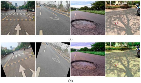
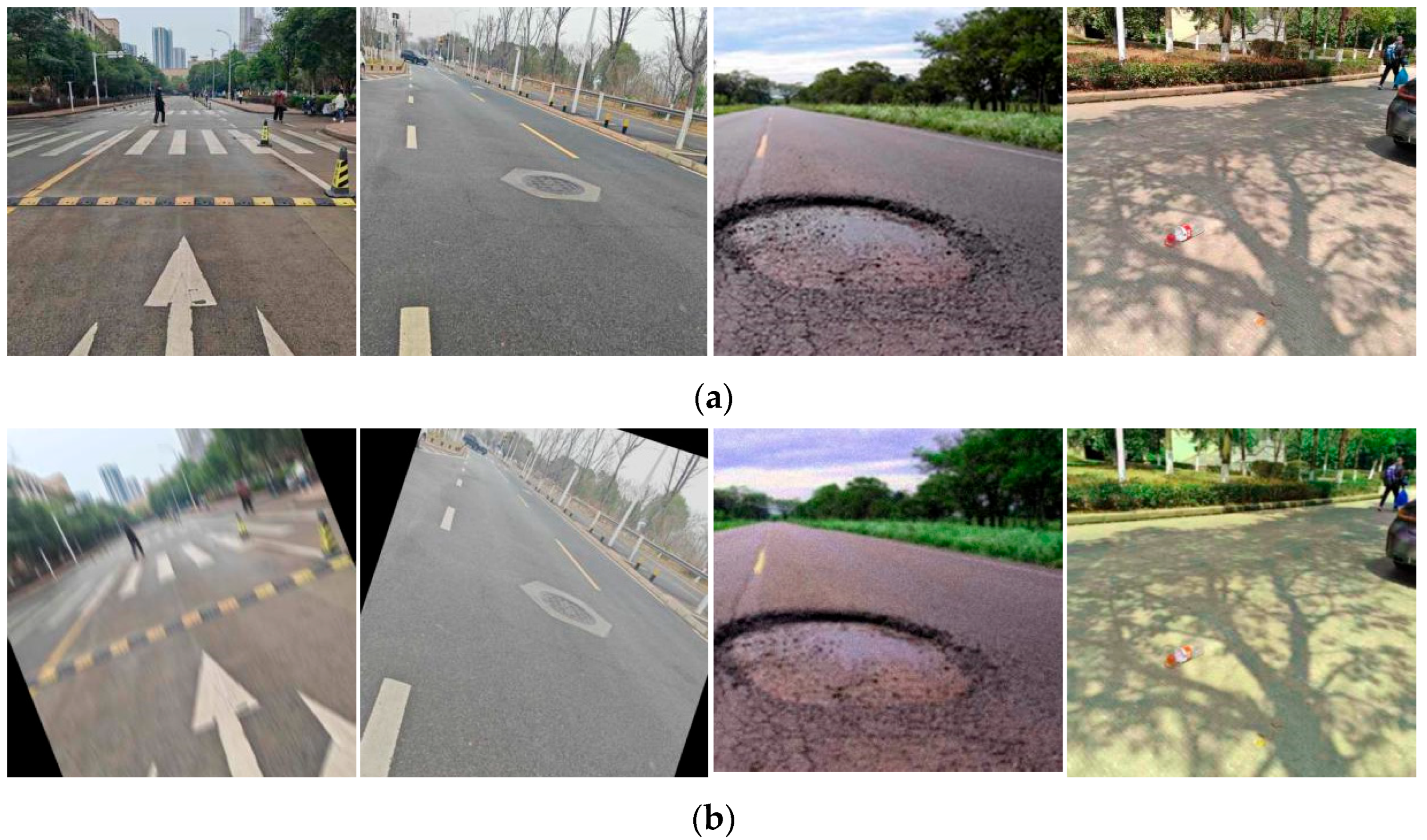
The data sources for each category are summarized as follows. The speed bump category includes 2100 images, mainly collected at national highway gas station entrances or exits and campus roads, covering typical conditions such as faded markings, structural variations, and scenarios where multiple speed bumps appear simultaneously. The manhole cover category consists of 2021 images collected from residential roads, campus roads, and urban arterial roads, encompassing diverse materials, shapes, and surface conditions. The pothole category contains 1703 images, mainly obtained from publicly available online sources, most of which were captured at close range using smartphones and focus on ground surface damage. The plastic bottle category includes 1773 images, primarily comprising common mineral water and beverage bottles, collected from campus roads and grass-covered areas to simulate typical temporary foreign obstacles encountered in real traffic scenarios. Overall, the dataset covers diverse viewing angles, illumination conditions, and background environments, as illustrated in Figure 3a [17].
Figure 3.
Comparison chart before and after data augmentation. (a) Original images (b) Augmented images.
In terms of shooting distance, most road obstacle images were captured within a range of 2–3 m, while a smaller portion falls within 3–10 m, and only a few samples extend to 10–50 m. Near-field samples dominate the dataset, which is consistent with the practical requirements of near-range road obstacle preview perception for intelligent vehicles. The shooting viewpoints are mainly front-facing or slightly downward-looking, closely matching the typical installation angle of vehicle-mounted forward-facing cameras.
Since some original images were captured at relatively high resolutions, all images were uniformly rescaled to 0.25× of their original spatial resolution to reduce storage consumption and improve training efficiency. Under the premise of maintaining consistency across all categories, this preprocessing step effectively preserves the key semantic and structural information of the targets. After preprocessing, most images in the dataset have resolutions of 640 × 640 pixels and 640 × 480 pixels, which are commonly adopted in object detection tasks.
During the image augmentation stage, multiple data augmentation strategies were applied to enhance dataset diversity and improve model generalization capability, as shown in Figure 3b. These strategies include: geometric transformations, such as small-angle random rotations (±10° to ±30°) to avoid unrealistic object inversion, and random translations to simulate camera shake or viewpoint shifts; illumination and color adjustments, including slight perturbations of brightness, contrast, saturation, and hue to simulate different lighting and weather conditions (e.g., sunny, cloudy, and post-rain scenarios); and noise and blur processing, in which Gaussian noise and salt-and-pepper noise are injected to simulate sensor interference, while Gaussian blur and motion blur are applied to emulate defocus and motion-induced degradation during vehicle movement [18]. To control the training scale, augmented images randomly replace original samples while keeping the total dataset size unchanged.
Following data preprocessing, all images were manually annotated in YOLO format by trained personnel in accordance with unified annotation guidelines. Specifically, tight axis-aligned bounding boxes were assigned to each road obstacle to accurately delineate object boundaries and avoid missing or incorrect annotations. After annotation, two rounds of manual quality inspection were conducted to correct potential labeling errors and ensure annotation quality. A portion of the finalized dataset has been publicly released to facilitate reproducibility and further validation.
The dataset was randomly partitioned into training, validation, and test subsets using an 8:1:1 split, comprising 6085, 757, and 755 images, respectively, as summarized in Table 1. This partitioning strategy supports stable training and reliable performance evaluation.
Table 1.
Dataset partitioning information.
4. Algorithm Introduction
4.1. YOLOv11
YOLO-based detectors, as a representative single-stage detection paradigm, have been widely adopted due to their high computational efficiency and fast inference speed [19]. As a member of this series, YOLOv11 inherits and further develops these advantages, making it well suited for road obstacle detection tasks in intelligent driving scenarios. Compared with earlier YOLO versions, YOLOv11 improves both localization and classification accuracy for various road obstacles, including speed bumps, manhole covers, potholes, and plastic bottles, through optimized network architecture design and enhanced feature fusion strategies.
As a single-stage detector, YOLOv11 achieves significantly faster inference speed than two-stage approaches such as Faster R-CNN, thereby enabling timely perception and response in real-time driving environments. In addition, the YOLOv11 model features a relatively simple architecture and moderate computational requirements. When deployed on resource-constrained platforms, such as industrial control computers, it can effectively utilize limited computing resources to support real-time obstacle detection. In contrast, many complex visual detection algorithms impose high demands on computational power and memory, which restricts their applicability under practical hardware constraints. Consequently, YOLOv11 provides a favorable balance between detection performance and deployment efficiency [20].
4.2. Network Model Optimization
Despite continuous innovations in network architecture, feature extraction, and bounding box regression, YOLOv11 achieves improved detection accuracy and a more compact model design while maintaining high inference efficiency. However, several limitations still exist when applying YOLOv11 to lightweight road obstacle detection tasks:
- Computational redundancy in the C3k2 module.
The C3k2 module typically consists of multiple convolutional layers and residual connections. Although residual structures help alleviate gradient vanishing and improve feature representation, the accumulation of convolutional operations introduces considerable computational overhead. Under lightweight design constraints, this redundancy becomes a bottleneck, reducing inference efficiency on resource-limited devices.
- 2.
- Parameter redundancy and insufficient contextual modeling in detection heads.
Feature maps at different scales are usually equipped with independent detection heads to handle targets of varying sizes. While this design provides a degree of flexibility, it also leads to parameter duplication and inefficient resource utilization. Moreover, conventional detection heads mainly focus on local feature information and tend to overlook surrounding contextual cues. In complex road environments, contextual information plays a critical role in accurately identifying obstacle categories and spatial locations. Insufficient context modeling may therefore result in false positives or missed detections.
- 3.
- High computational burden in the backbone and neck structures.
The backbone and neck components contain a large number of conventional convolutional layers. When processing high-resolution images, the computational cost increases substantially, leading to slower inference speed, which is unfavorable for intelligent driving applications with strict real-time requirements. In addition, the relatively large number of parameters increases storage demands and may cause overfitting during training, especially when the available dataset size is limited, thereby constraining the model’s generalization capability.
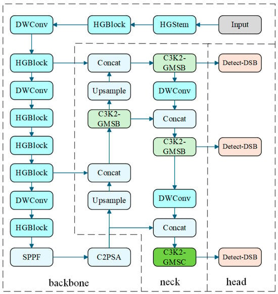
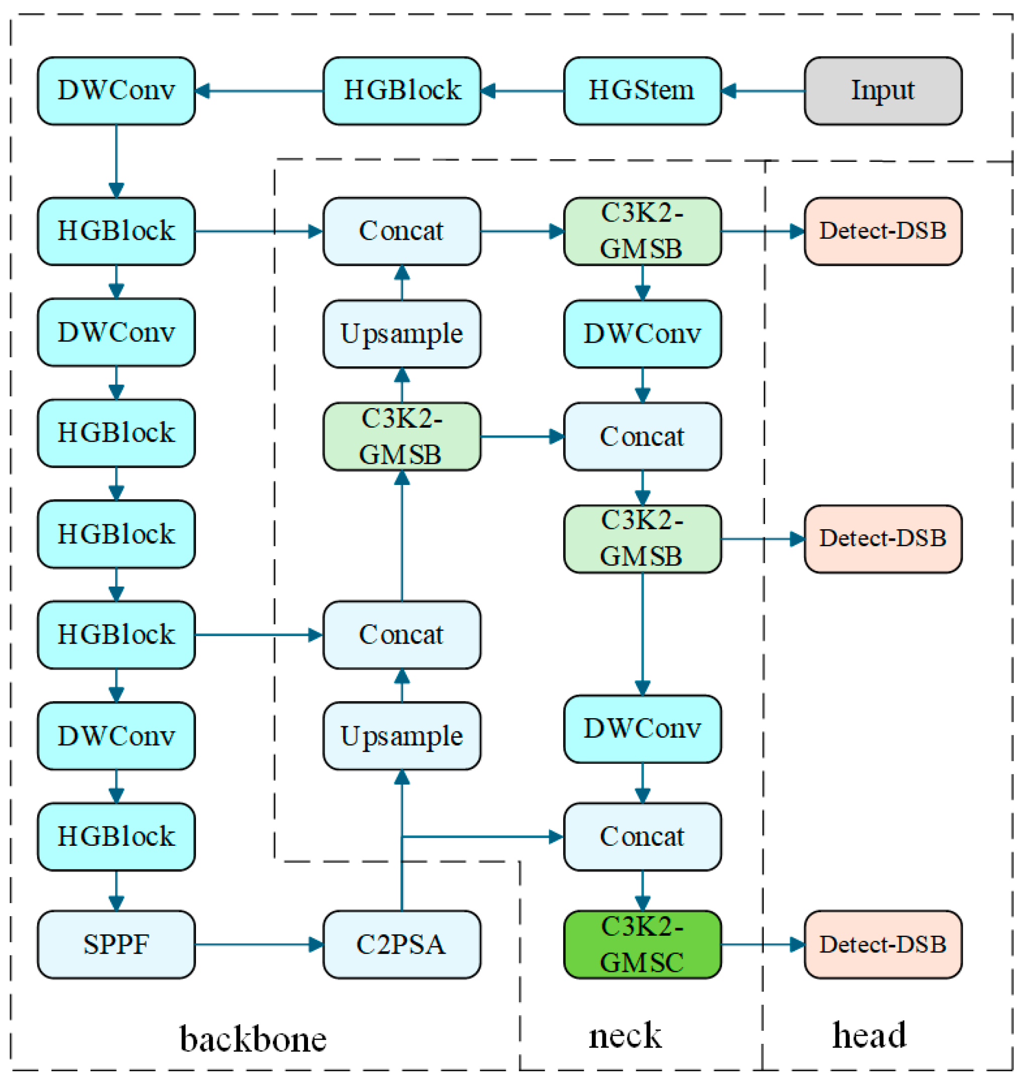
In response to the above limitations, an improved YOLOv11-based model is developed. The overall network architecture of the proposed method is illustrated in Figure 4.
Figure 4.
GroupScale-YOLO structure diagram.
4.2.1. C3k2-GMSC and C3k2-GMSB
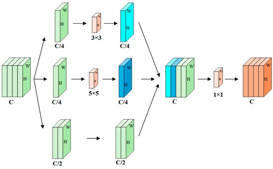
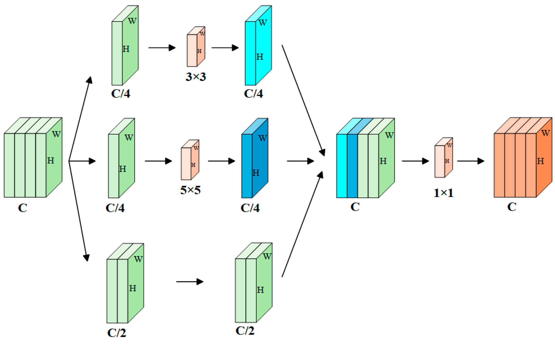
The proposed C3k2-GMSC (Grouped Multi-Scale Convolution) module, as illustrated in Figure 5, is designed to achieve an effective balance between computational efficiency and feature representation capability by integrating multi-scale feature fusion with dynamic channel reorganization. Specifically, the module introduces a channel-adaptive reorganization mechanism that divides the input feature map into two parallel paths: an information-preserving path that retains the original features and a feature-enhancement path that performs grouped convolution-based rearrangement. This dual-path design enables efficient cross-scale feature interaction while maintaining adaptive channel-wise weighting.
Figure 5.
Block diagram of C3k2-GMSC.
When the module receives the input feature map :
Divide along the channel direction to obtain a group of feature maps with the number of channels being C/2:
This portion of features is directly retained without further processing to preserve stable and original semantic information. Meanwhile, the remaining channels are further divided into two groups with C/4 channels each:
Convolution operations are then applied to these two feature groups using different kernel sizes, reflecting the advantages of collaborative multi-scale feature perception. By parallelly deploying convolution kernels of sizes 3 × 3 and 5 × 5, the module is able to simultaneously capture fine-grained local details of small-scale targets and broader contextual information associated with medium-scale targets.
The resulting feature maps, denoted as , possess distinct receptive fields. These multi-scale features are subsequently concatenated with the retained features to form an aggregated feature map :
This “divide–process–reorganize” strategy effectively expands the receptive field while avoiding the parameter explosion commonly observed in traditional multi-scale modules. By overcoming the limitations of single-scale convolutional kernels, the proposed design provides differentiated feature encoding for targets of varying sizes. Moreover, the dual-path structure, which combines feature preservation and multi-scale enhancement, contributes to more stable gradient propagation in deep networks.
Finally, a 1 × 1 pointwise convolution is employed to facilitate inter-channel information interaction and to fuse the spatial features extracted at different scales, generating the final output feature map. Compared with standard convolutional operations, this design significantly reduces model complexity while maintaining high detection accuracy.
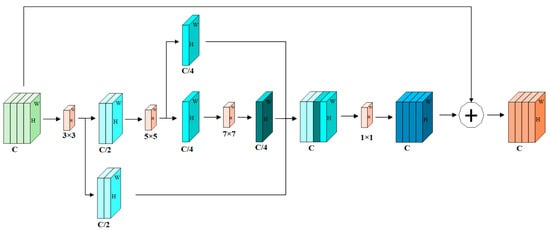
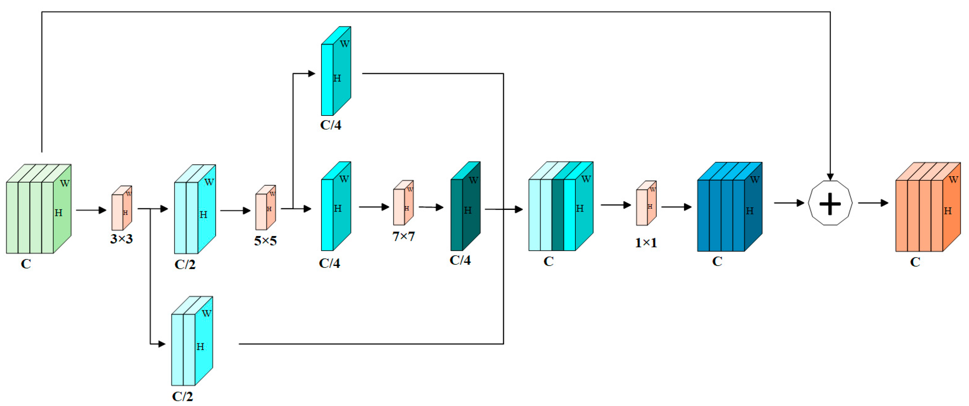
Due to channel partitioning constraints, the effectiveness of C3k2-GMSC becomes more pronounced in high-channel feature maps (e.g., 1024 channels). For feature maps with fewer channels, a complementary structure, termed C3k2-GMSB (Grouped Multi-Scale Block), as illustrated in Figure 6, is introduced. In this variant, the preprocessed feature map is divided into multiple sub-channel groups, and convolution kernels with different sizes are applied to extract diverse spatial features, thereby enhancing the model’s capability to handle scale variations.
Figure 6.
Block diagram of C3k2-GMSB.
Furthermore, a cascaded multi-scale integration strategy is adopted in C3k2-GMSB. Specifically, features processed by the 3 × 3 convolution are split into two parts: one part is retained for subsequent fusion, while the other is forwarded to a 5 × 5 convolution. The output of the 5 × 5 convolution is again divided, with one branch entering a 7 × 7 convolution and the other directly participating in the final feature aggregation. This progressive, layer-wise refinement strategy enables effective multi-scale feature integration while mitigating information loss.
The extracted features are concatenated along the channel dimension and compressed using a 1 × 1 pointwise convolution. Finally, a residual connection is applied to add the fused features back to the original input, which stabilizes gradient propagation and accelerates network convergence.
4.2.2. Detect-DSB
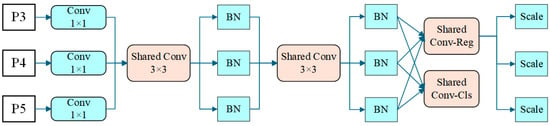
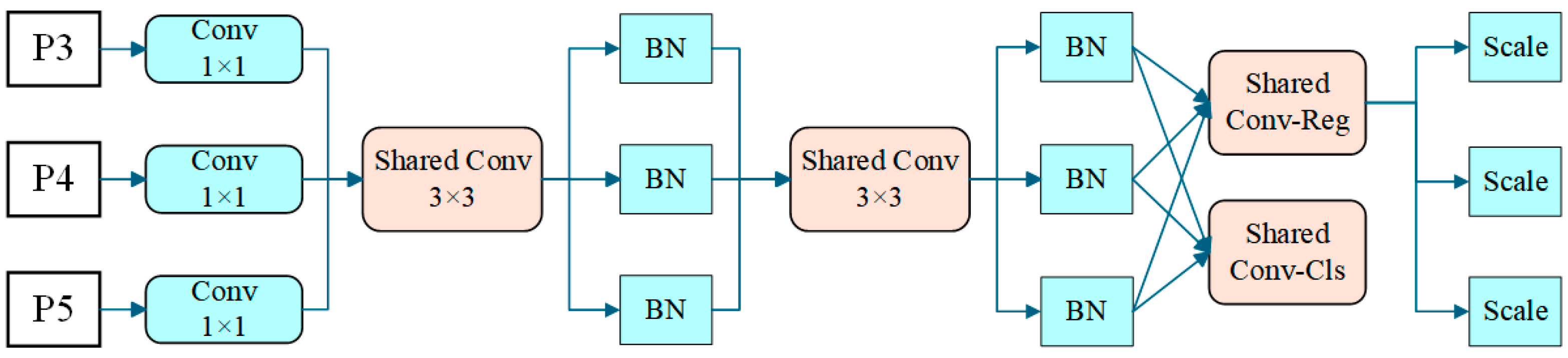
To improve parameter efficiency while maintaining stable inference across multi-scale features, a dynamic shared-normalization detection head, termed Detect-DSB, is introduced, as illustrated in Figure 7. In this design, the convolutional layers of the detection head are shared across different feature scales to reduce parameter redundancy and enhance semantic consistency, whereas normalization layers are independently maintained for each scale. This strategy effectively avoids the statistical bias that may arise from directly sharing Batch Normalization parameters across heterogeneous feature distributions, thereby improving both training stability and inference robustness without introducing additional computational overhead.
Figure 7.
Block diagram of the Detect-DSB detection head.
From a structural perspective, Detect-DSB first performs scale-specific feature adaptation through independent input branches. The adapted features are then processed by shared convolutional layers to achieve unified semantic representation across scales. This shared-convolution strategy significantly compresses the model size and facilitates faster convergence, while the scale-wise independent normalization layers preserve the statistical characteristics of features at different resolutions.
In addition, bounding box localization is further optimized by adopting Distribution Focal Loss (DFL). By modeling bounding box coordinates as discrete probability distributions, DFL enables higher regression precision without increasing architectural complexity. During inference, the regression and classification outputs from different scales are concatenated and jointly decoded, resulting in improved detection accuracy and robustness.
Overall, the proposed Detect-DSB detection head achieves a favorable balance between accuracy, computational efficiency, and deployment compatibility, making it well suited for lightweight YOLOv11-based models operating under embedded and real-time constraints.
4.2.3. DWConv
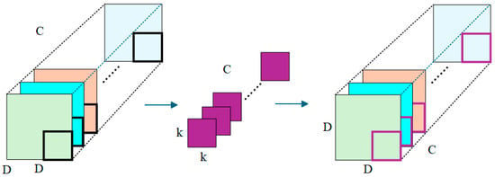
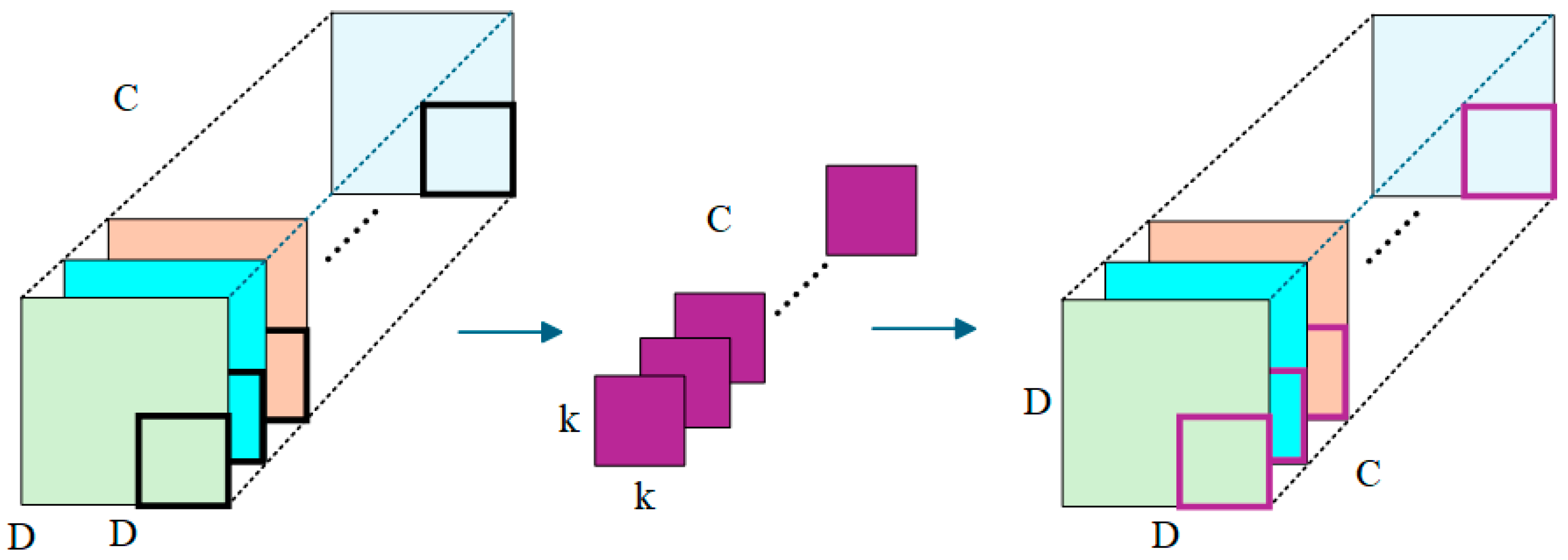
Depthwise convolution (DWConv), as illustrated in Figure 8, is an efficient convolutional operation that significantly reduces computational complexity by performing spatial convolution independently on each input channel. Unlike standard convolution, DWConv does not perform cross-channel information mixing; instead, it focuses on extracting spatial features within individual channels, thereby greatly decreasing the number of parameters and floating-point operations.
Figure 8.
Schematic diagram of DWConv.
In this study, the two standard convolutional layers in the neck module are replaced with depthwise convolutions. This modification effectively compresses the overall model size while preserving essential feature representation capability. At the same time, it improves inference efficiency, which is particularly beneficial for real-time deployment on resource-constrained embedded platforms.
4.2.4. HGNetV2
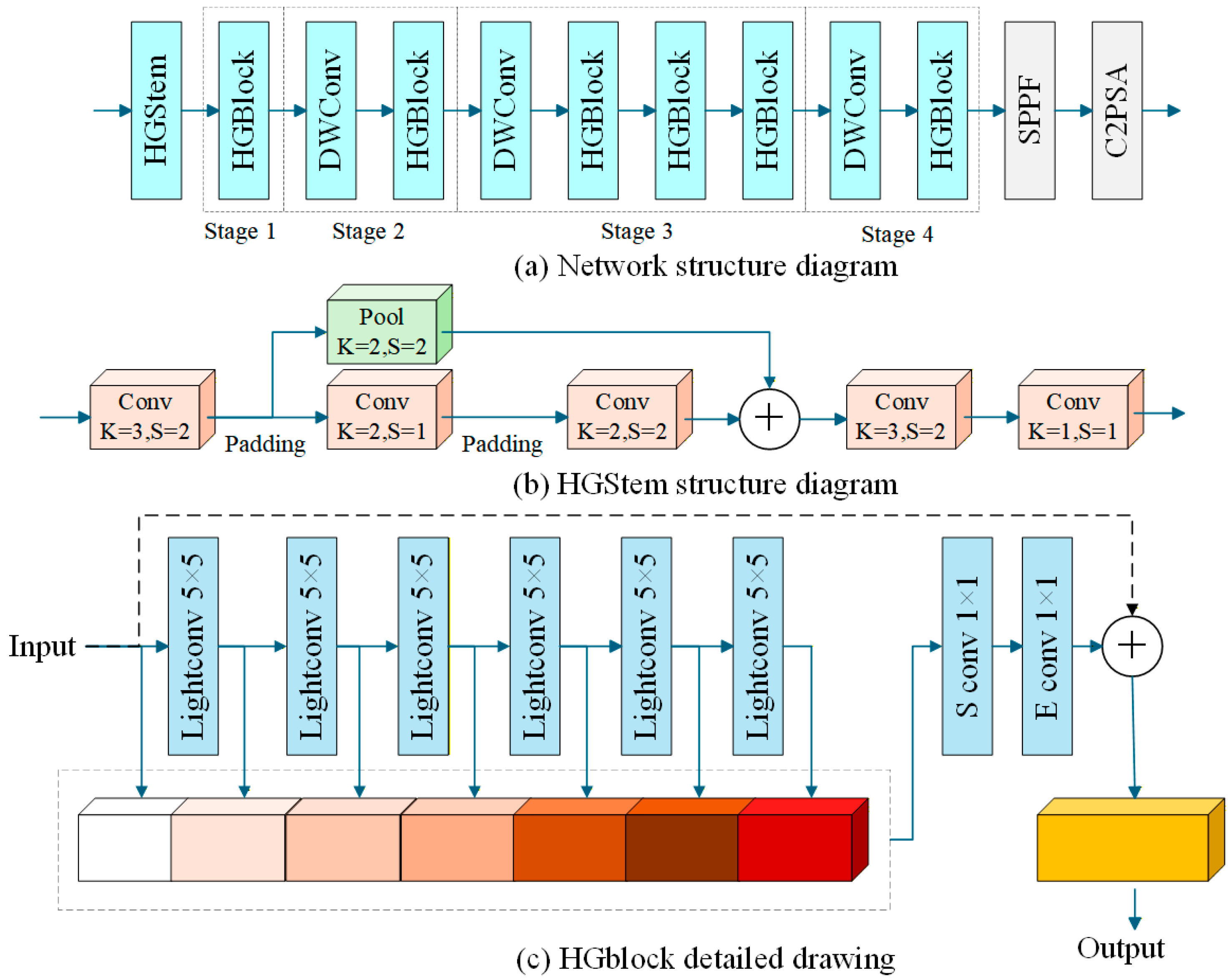
To further enhance feature representation capability under resource-constrained conditions, the original YOLOv11 backbone is replaced with the lightweight HGNetV2 architecture. Although efficient convolutional modules and a shared detection head are incorporated in the preceding design, the backbone network remains critical for modeling fine-grained details and multi-scale contextual information. HGNetV2 addresses this requirement through hierarchical residual connections and multi-scale feature aggregation, enabling more effective utilization of receptive fields with limited computational cost [21].
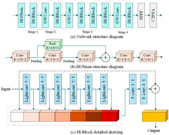
As illustrated in Figure 9, HGNetV2 is composed of a lightweight stem module followed by a sequence of HGBlocks. The stem module performs fast downsampling and preliminary feature encoding using a compact convolution–pooling structure, which reduces early-stage computational overhead while preserving essential low-level texture information [22]. The HGBlock serves as the fundamental building unit of the backbone and enhances multi-scale feature interaction via grid-based partitioning and cross-scale feature fusion, thereby mitigating the information loss of small targets during successive downsampling operations.
Figure 9.
Framework architecture of HGNetV2.
In addition, channel compression and feature refinement are achieved through squeeze-and-excitation convolutions, which reduce intermediate channel dimensions and selectively emphasize informative features using lightweight linear projections. Overall, the integration of HGNetV2 improves feature extraction efficiency and detection robustness while maintaining favorable characteristics for deployment on embedded vehicle-mounted platforms.
5. Experiments and Result Analysis
5.1. Evaluation Indicators and Experimental Environment
To evaluate the proposed detection model from multiple perspectives, a set of quantitative metrics is adopted, covering detection accuracy, computational complexity, and deployment-related resource consumption.
Detection performance is evaluated using Precision (P), Recall (R), and Mean Average Precision (mAP), which jointly characterize the model’s capability to correctly identify and localize target objects. Model complexity is assessed by the number of parameters (Params) and floating-point operations (FLOPs). The parameter count reflects storage requirements and hardware resource consumption, while FLOPs provide an indication of the computational load during inference. Models with larger values generally impose higher demands on computing platforms. In addition, model size is reported to describe the storage footprint of the trained network, which is closely related to deployment convenience in practical applications.
Together, these metrics enable a comprehensive evaluation of detection accuracy, efficiency, and resource consumption. The corresponding calculation formulas are defined as follows:
where TP, FP, and FN denote true positives, false positives, and false negatives, respectively.
In the evaluation framework, N represents the number of object categories. mAP@0.5 denotes the mean average precision computed at an Intersection-over-Union (IoU) threshold of 0.5, while mAP@0.5:0.95 represents the averaged mAP over IoU thresholds ranging from 0.5 to 0.95. AP (Average Precision) evaluates the detection performance of a single category, whereas mAP (Mean Average Precision) provides an overall quantitative assessment by aggregating AP values across all categories, and is therefore regarded as a core indicator for object detection performance.
All experiments were conducted under an identical hardware and software configuration to ensure fair comparison and reproducibility. The experimental environment is summarized in Table 2. The proposed GroupScale-YOLO and all baseline models were implemented based on the Ultralytics YOLOv11 framework and trained using the same training strategy unless otherwise specified.
Table 2.
Environment and parameter configuration.
For model training, all input images were resized to a spatial resolution of 640 × 640 pixels. The training process was conducted for 120 epochs with a batch size of 16 using stochastic gradient descent (SGD). The initial learning rate was set to 0.01, with momentum and weight decay values of 0.937 and 5 × 10⁻⁴, respectively. In addition, a linear warm-up strategy was employed during the first three epochs to facilitate stable convergence.
Pretrained weights were utilized for all models to accelerate training convergence. Mixed-precision training (AMP) was enabled to improve computational efficiency. To reduce randomness and enhance reproducibility, the random seed was fixed to 0 and deterministic training was adopted.
The training pipeline incorporated several data augmentation techniques provided by YOLOv11, including Mosaic image fusion, color-space perturbation, and random flipping. All ablation and comparative experiments were conducted under identical training configurations, and no additional hyperparameter tuning was performed for individual models.
5.2. Comparison Experiment of Backbone Networks
With the objective of reducing computational overhead without compromising detection accuracy, the original YOLOv11 backbone is replaced with several lightweight backbone networks for comparative evaluation. A set of representative lightweight architectures from mainstream networks, including StartNet [23], MobileNetV2 [24], MobileNetV4 [25], EfficientNetV2 [26], ShuffleNetV2 [27], LSKNet [28], and HGNetV2, are evaluated under a unified experimental configuration. The corresponding comparison results are summarized in Table 3.
Table 3.
Evaluation of backbone architectures.
The experimental results reveal a clear relationship between backbone complexity and detection performance. Among all evaluated models, HGNetV2 achieves the highest mAP@0.5 value of 0.834, outperforming EfficientNetV2 by 0.4%. This result indicates that, under an IoU threshold of 0.5, HGNetV2 provides the most accurate detection performance among the tested backbone networks. Moreover, HGNetV2 also attains the highest mAP@0.5:0.95 value of 0.420, demonstrating its superior robustness across varying IoU thresholds and its ability to maintain stable detection accuracy under stricter localization requirements.
In terms of computational complexity and storage cost, HGNetV2 exhibits relatively low FLOPs and model size, ranking second only to LSKNet in these aspects. Among the backbones that achieve comparatively high detection accuracy, namely EfficientNetV2, LSKNet, and HGNetV2, HGNetV2 demonstrates the fastest training speed while requiring fewer storage and computational resources. This balance between efficiency and accuracy makes it particularly suitable for practical deployment in real-world embedded scenarios.
Considering both detection performance and model efficiency, HGNetV2 maintains high accuracy while exhibiting favorable characteristics in terms of parameter scale, computational cost, and storage footprint. Consequently, HGNetV2 is selected as the backbone network to improve the overall performance of the YOLOv11-based detection framework.
5.3. Comparative Experiment of Target Detection Algorithms
A comparative evaluation is conducted between the proposed GroupScale-YOLO and four representative baseline models, namely YOLOv8n, YOLOv10n, YOLOv11n, and YOLOv12n, to comprehensively assess their performance in road obstacle detection tasks. The quantitative comparison results are reported in Table 4.
Table 4.
Comparative experimental results.
As shown in Table 4, GroupScale-YOLO achieves superior performance in Precision, mAP@0.5, and mAP@0.5:0.95 compared with the baseline models, indicating enhanced robustness in target recognition under different IoU thresholds. Although the Recall values of the compared methods remain close, GroupScale-YOLO exhibits a more favorable trade-off between detection accuracy and computational efficiency.
In addition, GroupScale-YOLO demonstrates clear advantages in lightweight deployment, maintaining competitive Recall performance while achieving improved overall efficiency. These results indicate that the proposed method effectively balances detection accuracy and model compactness, making it well suited for practical application scenarios with constrained computational and storage resources.
5.4. Ablation Experiments
A series of ablation experiments are conducted based on the YOLOv11n baseline to investigate the individual and combined effects of the proposed components. All experiments are performed under identical training settings, and only the corresponding architectural components are modified to ensure a fair comparison.
The proposed improvements can be categorized into three groups:
- (1)
- Group-scale feature modeling modules, including C3k2-GMSC and C3k2-GMSB, designed to enhance multi-scale geometric feature representation for road elevation-related objects;
- (2)
- Lightweight architectural modifications, consisting of the HGNetV2 backbone and depthwise convolution (DWConv), aiming to reduce model complexity and computational cost;
- (3)
- Detection head optimization, namely the Detect-DSB module, intended to improve parameter sharing efficiency during the prediction stage.
Each component is individually integrated into the baseline model to evaluate its influence on detection accuracy and model efficiency. The corresponding results are summarized in Table 5.
Table 5.
Results of ablation experiment.
As shown in Table 5, the baseline YOLOv11n model achieves an mAP@0.5 of 0.940 and an mAP@0.5:0.95 of 0.534, with 2.58 M parameters and 6.3 G FLOPs.
After introducing the C3k2-GMSC module, the parameter count and FLOPs are slightly reduced to 2.49 M and 6.2 G, respectively, while the mAP@0.5 remains unchanged at 0.940. A marginal decrease of 0.1% is observed in mAP@0.5:0.95. These results indicate that the proposed group-scale feature modeling can effectively suppress redundant channel responses and enhance feature compactness without degrading overall detection performance.
When the C3k2-GMSB module is independently integrated, the model achieves a comparable mAP@0.5 of 0.938 and a slight improvement in mAP@0.5:0.95 to 0.535, while maintaining parameter count and FLOPs close to the baseline. This suggests that GMSB contributes to fine-grained boundary feature representation, although its standalone impact on overall detection accuracy remains limited.
Replacing the original detection head with the Detect-DSB structure yields a 0.5% improvement in mAP@0.5 (from 0.940 to 0.945), while simultaneously reducing the number of parameters. This result demonstrates that enhanced parameter sharing in the detection head can improve object presence discrimination, particularly for road obstacles with distinctive geometric patterns, although its effect on high-IoU localization accuracy is relatively modest.
When the backbone is replaced with the lightweight HGNetV2 architecture, the parameter count and FLOPs are significantly reduced to 2.14 M and 5.7 G, respectively, while maintaining a comparable mAP@0.5 of 0.941. This confirms that HGNetV2 is capable of extracting discriminative features for road obstacle detection with improved computational efficiency.
Further introducing DWConv leads to a substantial reduction in parameters (1.92 M) and FLOPs (4.7 G). However, a noticeable decrease in mAP@0.5 to 0.931 is observed. This performance degradation indicates that applying depthwise separable convolution in isolation may limit the model’s ability to handle complex road textures and subtle elevation variations.
Overall, the single-module ablation results show that most proposed components contribute effectively to model lightweighting, whereas their individual improvements in detection accuracy are relatively limited. This observation motivates further analysis of the complementary effects among different modules.
To investigate the synergistic effects of the proposed components, a series of incremental combination experiments are conducted by progressively integrating multiple modules into the baseline architecture. When C3k2-GMSC and C3k2-GMSB are jointly introduced, the mAP@0.5 increases to 0.942 and the mAP@0.5:0.95 reaches 0.539, indicating complementary behavior in enhancing multi-scale geometric feature representation. Further integrating the Detect-DSB module maintains competitive detection accuracy while reducing the parameter count to 2.43 M, demonstrating improved efficiency in the detection stage.
Incorporating the HGNetV2 backbone provides a favorable balance between accuracy and efficiency, resulting in 1.99 M parameters, 5.7 G FLOPs, and an mAP@0.5 of 0.937. Finally, by integrating all proposed components, including DWConv, the complete GroupScale-YOLO model achieves the best overall performance, with an mAP@0.5 of 0.946 and an mAP@0.5:0.95 of 0.538, while maintaining a compact design of 1.81 M parameters, 5.5 G FLOPs, and a model size of 4.0 MB.
Compared with the baseline YOLOv11n, the final GroupScale-YOLO achieves approximately 29.95%, 12.70%, and 27.27% reductions in parameter count, FLOPs, and model size, respectively, along with improvements of 0.6% in mAP@0.5 and 0.4% in mAP@0.5:0.95. Although the absolute accuracy gains are modest, these results demonstrate that the proposed modules exhibit clear synergistic effects when combined, enabling efficient lightweight deployment without sacrificing detection performance.
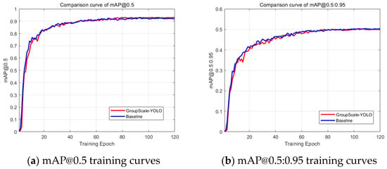
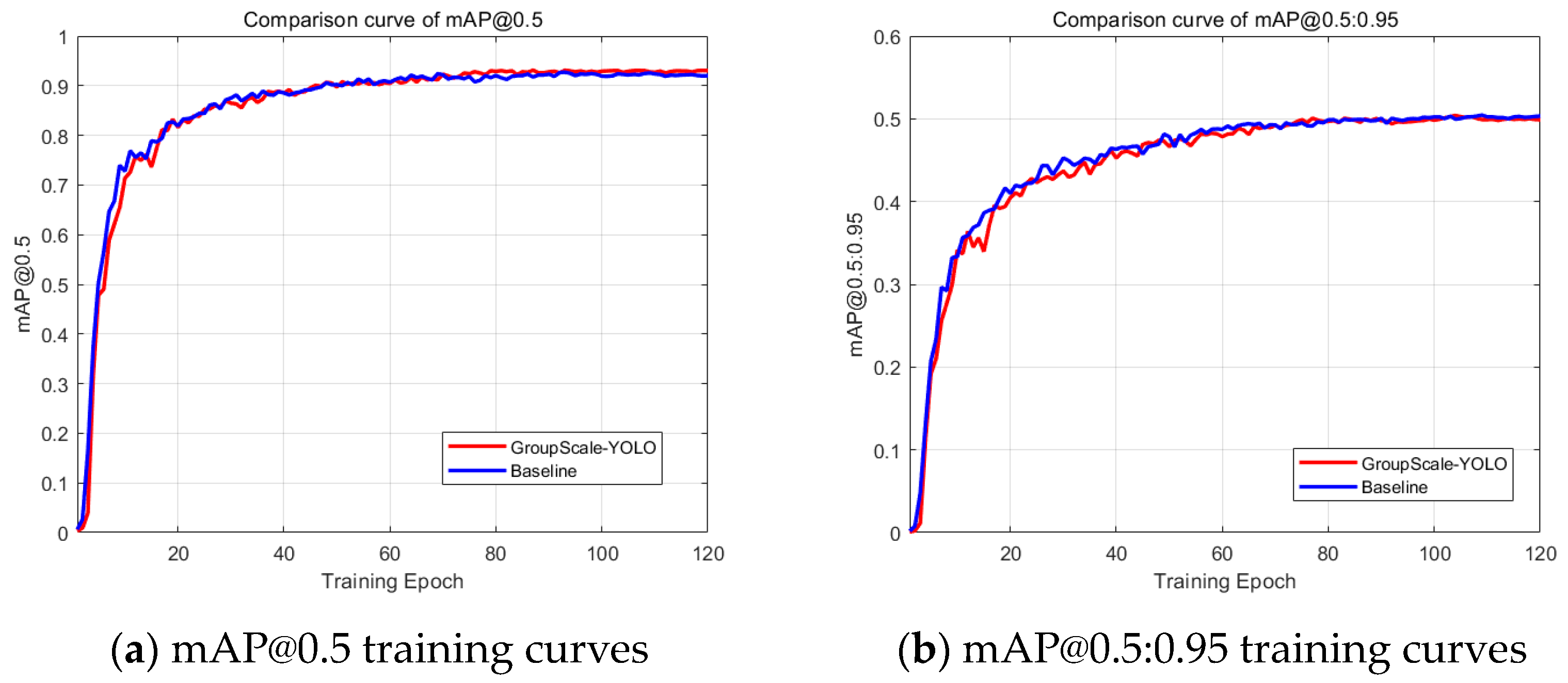
Figure 10 illustrates the training curves of mAP@0.5 and mAP@0.5:0.95 for both the baseline and the proposed model. The improved model exhibits slightly higher and more stable mAP@0.5 values during training, while maintaining a comparable mAP@0.5:0.95 level, indicating stable convergence behavior.
Figure 10.
mAP@0.5 and mAP@0.5:0.95 training curves.
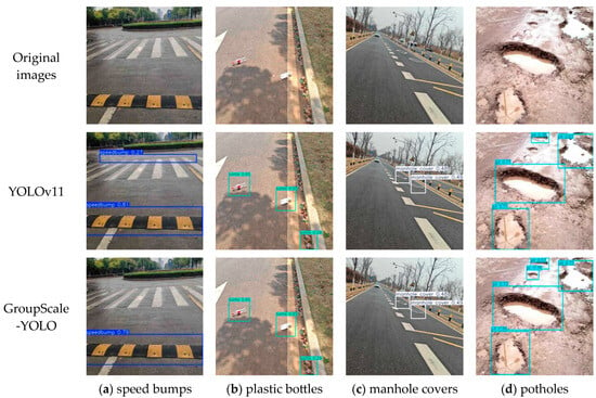
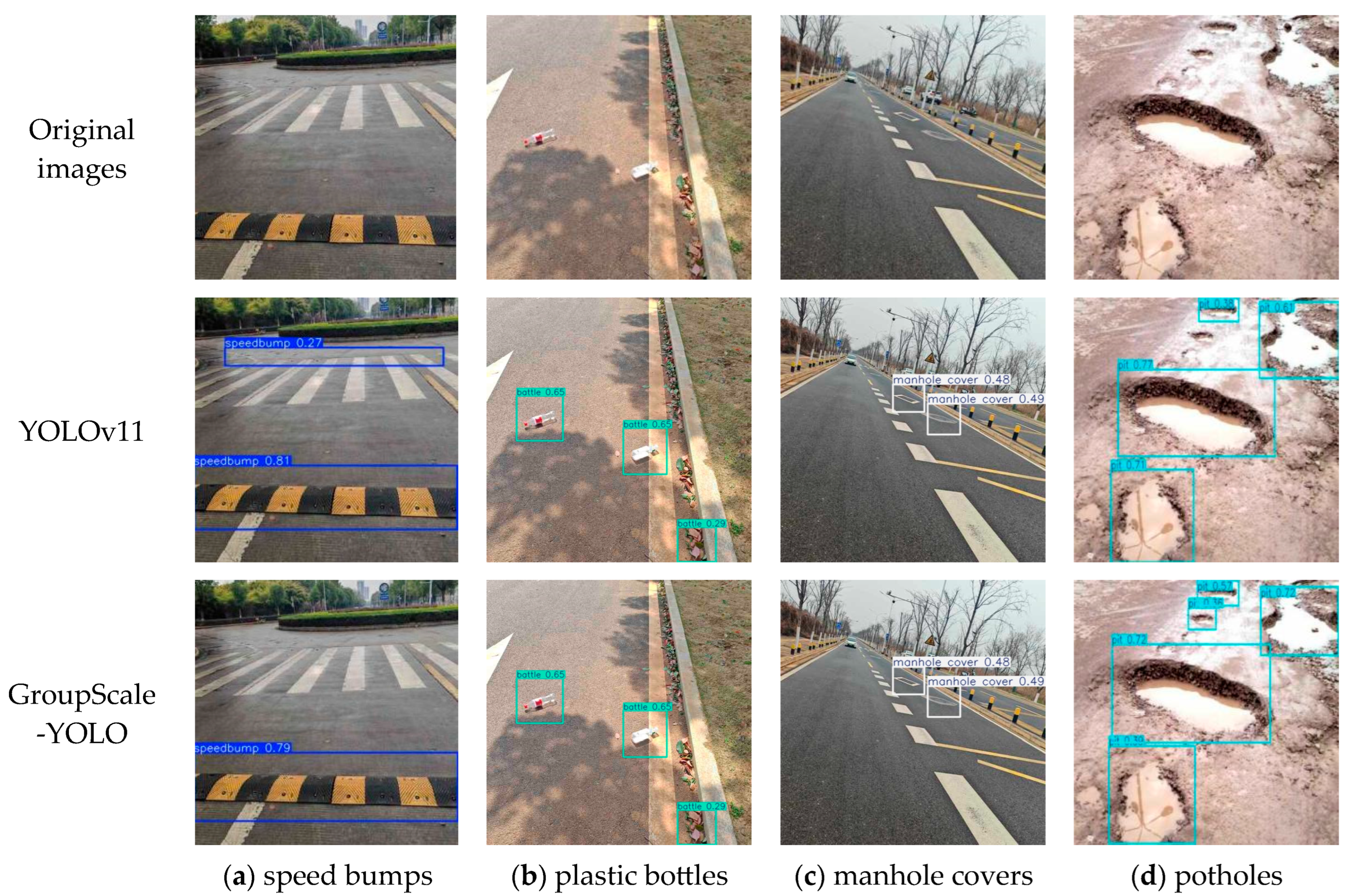
For qualitative evaluation, Figure 11 presents visual comparison results for four representative road obstacle categories, including manhole covers, speed bumps, plastic bottles, and potholes, under complex paved-road scenes. The first row shows the original images, followed by detection results from the baseline YOLOv11n and the proposed GroupScale-YOLO in the second and third rows, respectively. The baseline model exhibits several misdetections, such as confusing cement cracks near zebra crossings with speed bumps, roadside leaves with plastic bottles, and traffic signs with manhole covers, as well as missing small potholes with weak visual cues.
Figure 11.
Comparison charts of road obstacle detection effect.
In contrast, GroupScale-YOLO demonstrates improved robustness when handling complex ground textures and cluttered backgrounds while maintaining a lightweight structure. These visual results further confirm the effectiveness of the proposed group-scale feature modeling strategy for road obstacle detection.
5.5. External Dataset Validation
To further evaluate the robustness and generalization capability of GroupScale-YOLO across different data distributions, comparative experiments were conducted on the publicly available pothole–speed bump dataset, which is closely related to road elevation perception tasks [29]. This dataset consists of two representative categories of road surface irregularities, namely potholes and speed bumps, and exhibits scene characteristics highly consistent with the application background considered in this study.
Under identical training configurations, the performance of GroupScale-YOLO on the external dataset was compared with that of the YOLOv11n baseline. As reported in Table 6, GroupScale-YOLO achieves a 0.6% improvement in mAP@0.5 while maintaining a recall level comparable to the baseline. This result indicates that the proposed group-scale feature modeling mechanism contributes to more stable and consistent detection of road surface anomalies across different datasets.
Table 6.
Cross-dataset evaluation results on the pothole–speed bump dataset.
A slight decrease is observed in mAP@0.5:0.95, which reflects the stricter localization accuracy requirements imposed by this metric. In practical onboard road perception and preview applications, reliable target presence detection is often of higher priority than extremely precise bounding box regression. Therefore, despite the minor performance fluctuation at higher IoU thresholds, the experimental results still demonstrate the effectiveness and applicability of GroupScale-YOLO on external road elevation–related datasets.
5.6. Vehicle-Mounted Verification
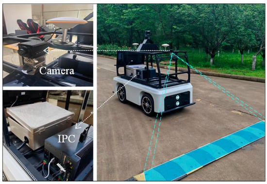
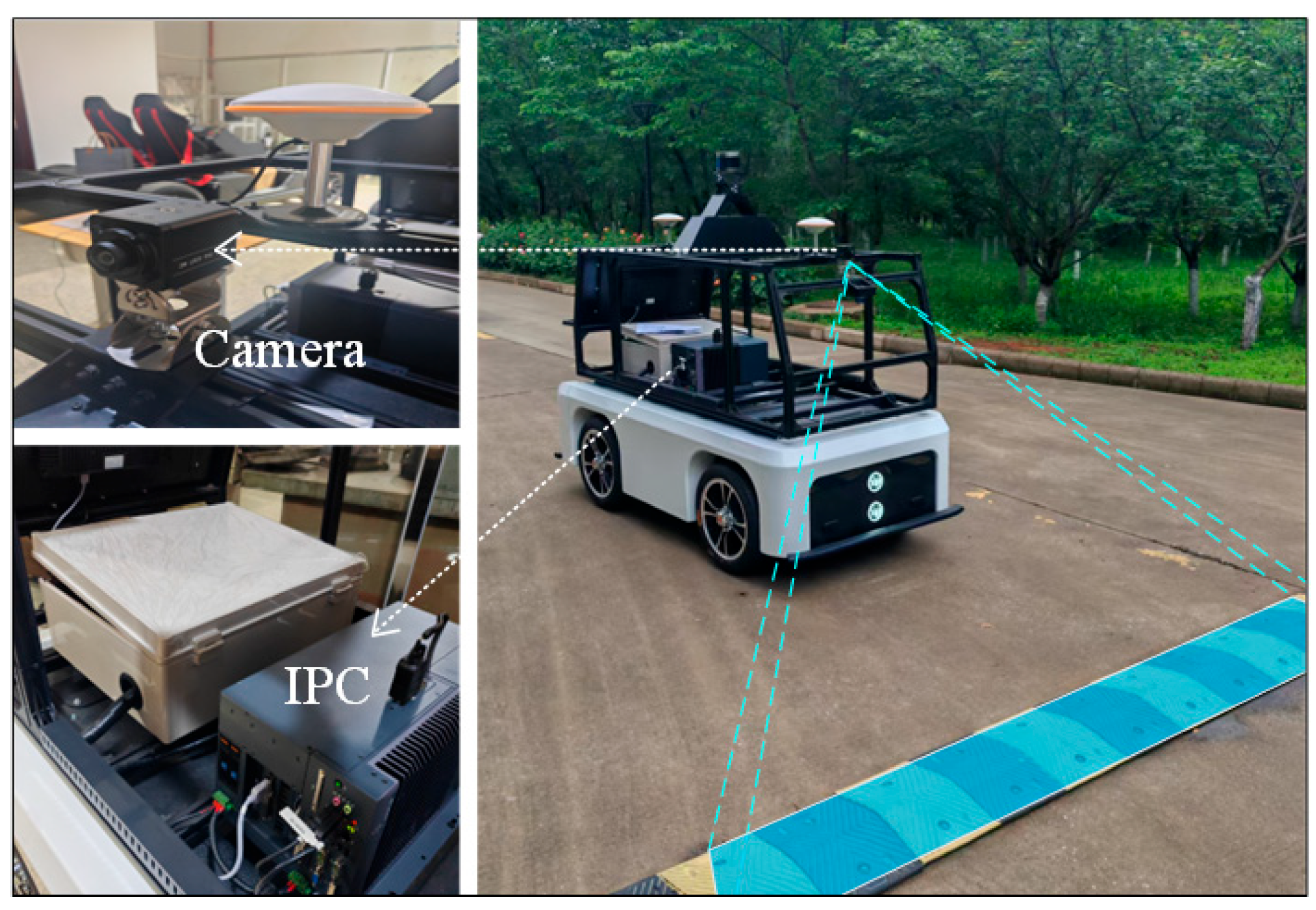
To further validate the practical deployability of GroupScale-YOLO, the proposed model was implemented on an experimental vehicle and evaluated under real driving conditions. The overall vehicle setup is illustrated in Figure 12.
Figure 12.
Experimental vehicle.
The experimental platform is equipped with an integrated computing module (NVIDIA Jetson Orin 32 GB, NVIDIA Corporation, Santa Clara, CA, USA), which serves as the core processing unit for perception-related tasks. The onboard computing system includes an 8-core Arm® Cortex®-A78AE v8.2 64-bit CPU and an integrated GPU provided by the Jetson Orin module, supported by 32 GB of system memory and a 1 TB SATA SSD. This hardware configuration offers sufficient computational capability for real-time visual inference under power- and resource-constrained embedded environments.
An industrial camera based on the Sony (Atsugi, Kanagawa, Japan) IMX291 CMOS image sensor was adopted as the vision sensor. The camera provides an effective resolution of 1920 × 1080 (approximately 2 MP) and a wide field of view of 140°. It is connected to the onboard computing unit via a USB interface and maintains stable operation over a temperature range of −20 °C to 70 °C, making it suitable for outdoor vehicle-mounted applications.
In the vehicle-level experiments, the trained GroupScale-YOLO model was deployed directly on the embedded platform under a Linux-based runtime environment, without applying additional model pruning, quantization, or hardware-specific operator optimization. This deployment strategy was intentionally adopted to evaluate the native inference capability and runtime stability of the proposed model on an embedded system.
The primary objective of the vehicle-mounted experiments is to assess the real-time inference performance, system stability, and deployability of GroupScale-YOLO on an embedded platform, rather than to establish a large-scale benchmark for vehicle-level detection performance.
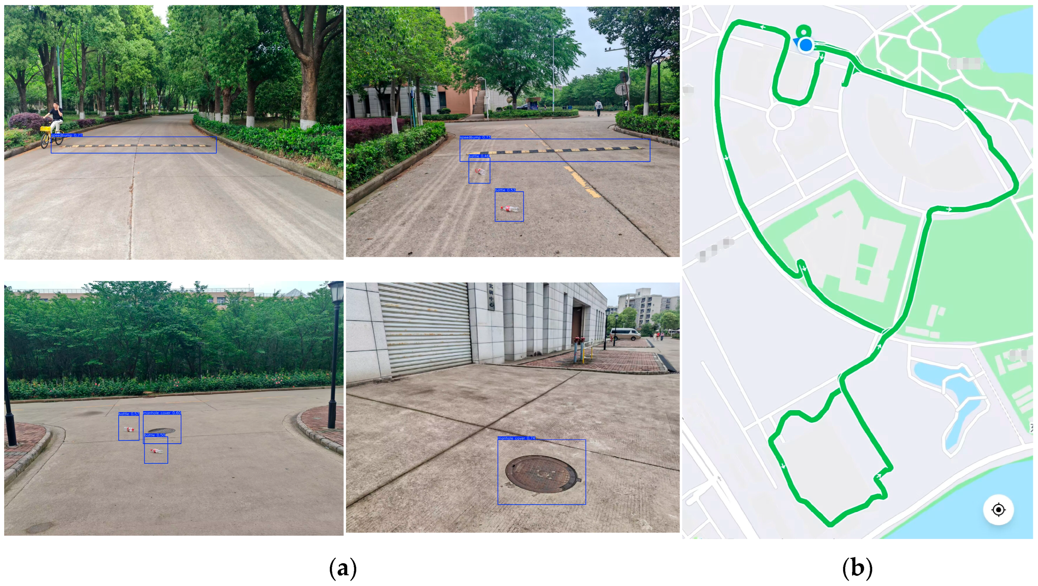
During the experiments, the vehicle was driven along paved campus roads at a maximum speed of 20 km/h, covering a total distance of 2.46 km. The detection targets included speed bumps, manhole covers, and plastic bottles. The detailed experimental parameters and workflow are summarized in Table 7 and Figure 13, respectively.
Table 7.
Experimental parameters.
Figure 13.
Vehicle-mounted experiment. (a) test effect (b) Experimental route.
The quantitative results of the vehicle-mounted detection experiments are presented in Table 8. The reported detection distance represents the average distance between the vehicle and an obstacle at the moment of initial detection and should be interpreted as an approximate reference value rather than an exact measurement.
Table 8.
Experimental results.
FPS (Frames Per Second) is commonly used to evaluate the inference efficiency of object detection models, indicating the number of frames processed per second. In the vehicle-mounted experiments, GroupScale-YOLO achieved an inference speed of 69 FPS, while the onboard video stream was recorded at 30 FPS, demonstrating that the proposed system fully satisfies real-time perception requirements for low-speed vehicle operation.
The test route included 17 speed bumps, 48 manhole covers, and 80 plastic bottles. All speed bumps and manhole covers were successfully detected, while seven plastic bottles were not recognized, resulting in an overall detection accuracy of 95.17%. Further analysis indicates that the missed detections mainly occurred when plastic bottles were located at relatively long distances from the vehicle or when the bottom surfaces of empty bottles faced the camera. In such cases, the bottles exhibited weak texture information and partial transparency, which reduced their visual saliency and made reliable recognition more challenging.
During the experiments, noticeable variations were observed in the initial detection distance for different obstacle categories. Speed bumps were typically detected at distances of approximately 15 m, manhole covers at around 10 m, and plastic bottles at approximately 7 m. Stable and consistent detection performance was achieved when the distance to the target was within 7 m. This phenomenon is closely related to the data distribution of the training dataset, in which the majority of samples were collected within a 7 m range. As a result, the model demonstrates higher robustness and accuracy at closer distances, while detection performance gradually degrades for targets located beyond this range due to limited long-distance samples.
In addition to missed detections, several types of false detections were observed during real-world vehicle operation. Specifically, certain road surface textures were occasionally misclassified as speed bumps, circular water accumulations were sometimes recognized as manhole covers, and manhole covers partially covered by water were occasionally detected as potholes. Moreover, plastic bottles exhibited the highest false detection frequency, with visually similar objects such as white road debris, roadside flowers, and pedestrians’ shoes being incorrectly identified. These errors are primarily attributed to visual appearance similarities under complex outdoor conditions, as well as the limited color and texture cues available for small or low-contrast objects in compressed training samples.
Despite these challenges, the vehicle-mounted experiments demonstrate that GroupScale-YOLO is capable of providing stable and real-time obstacle detection under realistic driving conditions. The observed false detections highlight inherent difficulties in road-scene perception caused by environmental complexity and appearance ambiguity, rather than fundamental limitations of the proposed model. Future work will focus on expanding dataset diversity, particularly for long-distance and visually ambiguous targets, to further enhance robustness and reduce false detections in complex real-world scenarios.
6. Conclusions
To enhance the perception capability of intelligent vehicles in complex road environments, this paper proposes a lightweight and efficient road obstacle detection framework named GroupScale-YOLO, which is built upon grouped multi-scale convolution. A dedicated obstacle detection dataset for urban paved roads was constructed, covering four typical road surface objects—speed bumps, manhole covers, potholes, and plastic bottles—under diverse background conditions.
From the perspective of network architecture design, group-scale feature modeling was introduced to improve multi-scale geometric representation while controlling computational cost. Specifically, the proposed C3k2-GMSC and C3k2-GMSB modules leverage grouped convolution and parallel multi-kernel operations to capture fine-grained spatial features at different scales. This design effectively enhances feature compactness and representation efficiency without increasing model complexity.
To address parameter redundancy in multi-scale prediction, a Detect-DSB shared convolutional detection head was adopted. By sharing convolutional layers across feature scales while preserving independent normalization statistics, the detection head improves parameter utilization efficiency and maintains training stability. In addition, lightweight architectural optimizations, including the integration of DWConv in the neck and the adoption of the HGNetV2 backbone, further reduce model parameters and computational overhead while preserving detection capability.
Experimental results demonstrate that the optimized GroupScale-YOLO model achieves a 29.95% reduction in parameters, accompanied by consistent performance improvements, including increases of 0.2% in precision, 0.3% in recall, 0.6% in mAP@0.5, and 0.4% in mAP@0.5:0.95. Extensive ablation studies, cross-dataset validation, and vehicle-mounted experiments collectively verify the effectiveness, robustness, and real-time deployability of the proposed method under resource-constrained embedded conditions.
Despite these improvements, the model still exhibits occasional false detections and missed detections, particularly in long-range scenarios with weak visual cues. Future work will focus on enhancing long-distance perception capability and further improving robustness under challenging environmental conditions.
Author Contributions
Conceptualization, W.H. and J.Z.; methodology, W.H.; software, W.H. and K.W.; validation, W.H., K.W. and Z.S.; formal analysis, W.H.; investigation, F.W.; resources, W.H.; data curation, J.Z. and F.W.; writing—original draft preparation, W.H.; writing—review and editing, Z.S. and K.W.; visualization, J.Z.; supervision, J.Z. and F.W.; project administration, W.H.; funding acquisition, J.Z. All authors have read and agreed to the published version of the manuscript.
Funding
This research was funded by the Project of National Natural Science Foundation of China (52202480) and the Project of Natural Science Foundation of Hubei Province (2022CFB732).
Data Availability Statement
Since the research project described in this article is ongoing, the experimental datasets generated during the study are temporarily unavailable. However, some of the used datasets have been made publicly available for sharing. Interested researchers may contact the corresponding author via institutional email for inquiries regarding specific technical implementations, including model architecture details or critical layer configurations.
Acknowledgments
We sincerely thank our advisor and fellow lab members for their tremendous support and guidance throughout the writing of this paper and the experimental validation. Finally, we are deeply grateful to the anonymous reviewers for their insightful comments and constructive suggestions.
Conflicts of Interest
The authors declare that they have no known competing financial interests or personal relationships that could have appeared to influence the work reported in this paper.
References
- Yang, M.; Fan, X. YOLOv8-Lite: A lightweight object detection model for real-time autonomous driving systems. ICCK Trans. Emerg. Top. Artif. Intell. 2024, 1, 1–16. [Google Scholar] [CrossRef] [Scilit]
- Eggen, K.; Fan, H. Speed Bump Detection Using Point Cloud Data. J. Geovisualization Spat. Anal. 2025, 9, 32. [Google Scholar] [CrossRef] [Scilit]
- Safyari, Y.; Mahdianpari, M.; Shiri, H. A Review of Vision-Based Pothole Detection Methods Using Computer Vision and Machine Learning. Sensors 2024, 24, 5652. [Google Scholar] [CrossRef] [Scilit] [PubMed]
- Ma, L.; Chen, M. Road damage detection based on improved YOLO algorithm. Sci. Rep. 2025, 15, 28506. [Google Scholar] [CrossRef] [Scilit] [PubMed]
- Li, G.; Xie, H.; Yan, W.; Chang, Y.; Qu, X. Detection of Road Objects With Small Appearance in Images for Autonomous Driving in Various Traffic Situations Using a Deep Learning Based Approach. IEEE Access 2020, 8, 211164–211172. [Google Scholar] [CrossRef] [Scilit]
- Zhou, Y.; Wen, S.; Wang, D.; Mu, J.; Richard, I. Object Detection in Autonomous Driving Scenarios Based on an Improved Faster-RCNN. Appl. Sci. 2021, 11, 11630. [Google Scholar] [CrossRef] [Scilit]
- Zhao, H.; Zhang, S.; Peng, X.; Lu, Z.; Li, G. Improved object detection method for autonomous driving based on DETR. Front. Neurorobotics 2025, 18, 1484276. [Google Scholar] [CrossRef] [Scilit]
- Zhou, Y.; Wen, S.; Wang, D.; Meng, J.; Mu, J.; Irampaye, R. MobileYOLO: Real-Time Object Detection Algorithm in Autonomous Driving Scenarios. Sensors 2022, 22, 3349. [Google Scholar] [CrossRef] [Scilit]
- Xu, L.; Yan, W.; Ji, J. The research of a novel WOG-YOLO algorithm for autonomous driving object detection. Sci. Rep. 2023, 13, 3699. [Google Scholar] [CrossRef] [Scilit]
- Jin, M.; Zhu, Z.; Tu, R.; Lv, A.; Yu, Z. AVD-YOLO: Active Vision-Driven Multi-Scale Feature Extraction for Enhanced Road Anomaly Detection. Information 2025, 16, 1064. [Google Scholar] [CrossRef] [Scilit]
- Cao, J.; Zhang, T.; Hou, L.; Nan, N. An improved YOLOv8 algorithm for small object detection in autonomous driving. J. Real-Time Image Process. 2024, 21, 138. [Google Scholar] [CrossRef] [Scilit]
- Jiang, L.; Ma, G.; Guo, W.; Sun, Y. YOLO-DH: Robust Object Detection for Autonomous Vehicles in Adverse Weather. Electronics 2025, 14, 4476. [Google Scholar] [CrossRef] [Scilit]
- Ren, H.; Jing, F.; Li, S. DCW-YOLO: Road Object Detection Algorithms for Autonomous Driving. IEEE Access 2025, 13, 125676–125688. [Google Scholar] [CrossRef] [Scilit]
- Ji, P.; Jiang, Z. SDO-YOLO: A Lightweight and Efficient Road Object Detection Algorithm Based on Improved YOLOv11. Appl. Sci. 2025, 15, 11344. [Google Scholar] [CrossRef] [Scilit]
- Liang, E.; Wei, D.; Li, F.; Lv, H.; Li, S. Object detection model of vehicle-road cooperative autonomous driving based on improved YOLO11 algorithm. Sci. Rep. 2025, 15, 32348. [Google Scholar] [CrossRef] [Scilit]
- Shi, S.; Ni, J.; Kong, X.; Zhu, H.; Zhan, J.; Sun, Q.; Xu, Y. An Obstacle Detection Method Based on Longitudinal Active Vision. Sensors 2024, 24, 4407. [Google Scholar] [CrossRef] [Scilit]
- El-Shair, Z.A.; Abu-raddaha, A.; Cofield, A.; Alawneh, H.; Aladem, M.; Hamzeh, Y.; Rawashdeh, S.A. SID: Stereo Image Dataset for Autonomous Driving in Adverse Conditions. In Proceedings of the NAECON 2024 IEEE National Aerospace and Electronics Conference, Dayton, OH, USA, 15–18 July 2024; pp. 403–408. [Google Scholar] [CrossRef] [Scilit]
- Shorten, C.; Khoshgoftaar, T.M. A survey on Image Data Augmentation for Deep Learning. J. Big Data 2019, 6, 60. [Google Scholar] [CrossRef] [Scilit]
- Redmon, J.; Divvala, S.; Girshick, R.; Farhadi, A. You Only Look Once: Unified, Real-Time Object Detection. In Proceedings of the 2016 IEEE Conference on Computer Vision and Pattern Recognition (CVPR), Las Vegas, NV, USA, 27–30 June 2016; pp. 779–788. [Google Scholar] [CrossRef] [Scilit]
- Wei, J.; As’arry, A.; Rezali, K.A.M.; Yusoff, M.Z.M.; Ma, H.; Zhang, K. A Review of YOLO Algorithm and Its Applications in Autonomous Driving Object Detection. IEEE Access 2025, 13, 93688–93711. [Google Scholar] [CrossRef] [Scilit]
- Wang, H.; Zhang, J.; Cheng, H. HRA-YOLO: An Effective Detection Model for Underwater Fish. Electronics 2024, 13, 3547. [Google Scholar] [CrossRef] [Scilit]
- Zhang, L.; Yu, S.; Yang, B.; Zhao, S.; Huang, Z.; Yang, Z.; Yu, H. YOLOv8 forestry pest recognition based on improved re-parametric convolution. Front. Plant Sci. 2025, 16, 1552853. [Google Scholar] [CrossRef] [Scilit]
- Gao, M.; Xu, M.; Davis, L.; Socher, R.; Xiong, C. StartNet: Online Detection of Action Start in Untrimmed Videos. In Proceedings of the 2019 IEEE/CVF International Conference on Computer Vision (ICCV), Seoul, Republic of Korea, 27 October–2 November 2019; pp. 5541–5550. [Google Scholar] [CrossRef] [Scilit]
- Yuan, P.; Chen, Z.; Jin, Q.; Xu, Y.; Xu, H. Lightweight lotus phenotype recognition based on MobileNetV2-SE with reliable pseudo-labels. Comput. Electron. Agric. 2025, 232, 110080. [Google Scholar] [CrossRef] [Scilit]
- Wu, Y. A Lightweight Modulation Recognition Network Based on MobileNetV4. Appl. Comput. Eng. 2025, 146, 43–50. [Google Scholar] [CrossRef] [Scilit]
- Feng, K.; He, S.; Wu, X.; Jiang, P.; Huang, S. Enhanced YOLOv5 for micro-defect detection on KDP crystal surfaces: A fusion of EfficientNetV2 and normalized Wasserstein distance. J. Real-Time Image Process. 2025, 22, 72. [Google Scholar] [CrossRef] [Scilit]
- Ning, S.; Wang, Y.; Cai, W.; Zhang, Z.; Wu, Y.; Ren, Y.; Du, K. Research on Intelligent Fault Diagnosis of Rolling Bearing Based on Improved ShufflenetV2-LSTM. J. Sens. 2022, 2022, 8522206. [Google Scholar] [CrossRef] [Scilit]
- Li, Y.; Li, X.; Dai, Y.; Hou, Q.; Liu, L.; Liu, Y.; Cheng, M.-M.; Yang, J. LSKNet: A Foundation Lightweight Backbone for Remote Sensing. Int. J. Comput. Vis. 2024, 133, 1410–1431. [Google Scholar] [CrossRef] [Scilit]
- External Dataset. Available online: https://www.kaggle.com/datasets/belmanasoufyane/pothole-speedbumps (accessed on 22 December 2025).

Disclaimer/Publisher’s Note: The statements, opinions and data contained in all publications are solely those of the individual author(s) and contributor(s) and not of MDPI and/or the editor(s). MDPI and/or the editor(s) disclaim responsibility for any injury to people or property resulting from any ideas, methods, instructions or products referred to in the content. |
© 2026 by the authors. Licensee MDPI, Basel, Switzerland. This article is an open access article distributed under the terms and conditions of the Creative Commons Attribution (CC BY) license.