


Highlights
What are the main findings?
- The paper develops a unified modelling framework that links mission tasks, forms of artificial intelligence use, and system-level performance for Unmanned Aerial Vehicles operating in difficult civil missions.
- The modelling results show that the quality of perception and tracking at the early stage of a mission influences the overall probability of mission success under degraded environmental and communication conditions.
What are the implications of the main findings?
- The framework provides a methodological basis for the design and analysis of AI-enabled UAV systems for safety-critical civil missions by offering a structured way to connect subsystem-level AI performance with mission-level outcomes.
- The proposed methodology can support requirement analysis and design-space exploration, including reasoning about AI quality characteristics, assignment of autonomous and automatic modes, comparison of UAV architectures and mission scenarios, and experimental validation.
Abstract
Unmanned Aerial Vehicles (UAVs) are increasingly used in complex civil missions that require reliable operation under uncertainty, creating a need for formal methods to assess how artificial intelligence (AI) contributes to mission performance. This study develops and evaluates a unified modelling framework for AI-enabled UAV systems operating in autonomous and automatic modes on small- and medium-class platforms across different operational configurations, including both single-UAV and multi-UAV deployments. The framework combines a structured decomposition of mission tasks—Environmental Sensing and Monitoring, Situational Awareness, Communication and Sensing Interference Resilience, Hazard and Restricted-Zone Avoidance, and Mission Execution and Intervention—with binary set descriptions, Bayesian Networks (BN), and Reliability Block Diagrams (RBD). This integration enables consistent mapping between mission tasks, AI utilisation approaches, and system-level performance characteristics while accounting for environmental disturbances, communication degradation, and mission constraints. The results show that the framework supports scenario-based analytical evaluation of UAV effectiveness and enables assessment of how AI-enabled perception-stage performance influences mission-level success in a civil Chemical, Biological, Radiological, Nuclear, and Explosive (CBRNe) environment. The proposed framework provides a methodological basis for the design, analysis, and future experimental validation of AI-enabled UAV systems for safety-critical civil missions.
1. Introduction
Unmanned Aerial Vehicles (UAVs) are increasingly deployed in complex civil missions that require rapid data acquisition, adaptive decision support, and reliable operation under uncertainty [1]. Recent advances in artificial intelligence (AI), onboard sensing, and autonomous control have significantly expanded UAV capabilities in applications such as disaster response, critical infrastructure monitoring, Chemical, Biological, Radiological, Nuclear, and Explosive (CBRNe) incident assessment, search-and-rescue, environmental surveillance, and emergency logistics. In these contexts, UAVs can improve the speed and quality of operational decision-making while reducing human personnel’s exposure to hazardous environments [2,3].
The growing complexity of such missions creates demand for new approaches to the design and use of AI-enabled UAVs. Incomplete information, degraded communications, time-critical decisions, environmental interference, and dynamic hazards often characterise civil operational environments. Under such conditions, conventional pre-programmed control may be insufficient, and additional AI functionality may be required to support sensing, interpretation, prioritisation, navigation, coordination, and mission execution. At the same time, the usefulness of AI components should be justified not only conceptually but also through formal modelling of UAV operation in autonomous and automatic modes.
This study addresses that need by developing and analysing mathematical models for UAVs equipped with AI components. The focus is on two functional modes of UAV operation, namely autonomous and automatic, and on their suitability for different categories of civil mission tasks. In particular, the paper considers tasks related to environmental sensing and monitoring, situational awareness, resilience to communication and sensing interference, hazard and restricted-zone avoidance, and mission execution and intervention in complex civil scenarios.
The purpose of the study is to assess different usage scenarios for AI components deployed on board UAVs, accounting for the major functional modes of UAV operation and the requirements of challenging civil missions. To achieve this goal, the paper develops AI quality-based task models, set-theoretical and binary-relational models, a hierarchical UAV model, and scenario-oriented effectiveness models.
The paper is organised as follows. Section 2 reviews related work on UAV development, AI-enabled control, resilience, and mission-oriented applications relevant to civil emergency and infrastructure domains. Section 3 presents the proposed methodology based on AI quality models and binary set descriptions. Section 4 introduces the hierarchical UAV model and the architecture of the guidance and recognition system. Section 5 develops the mathematical models for scenario-based effectiveness assessment and presents the simulation results. Section 6 discusses the results obtained and their implications for the design and deployment of AI-enabled UAVs for complex civil missions. Section 7 concludes the paper and outlines directions for future work.
2. State of the Art
The rapid evolution of UAVs and AI technologies is driving major trends in their application to complex civil tasks. UAVs are increasingly being deployed for a wide range of roles, including disaster response, environmental monitoring, search-and-rescue (SAR), smart agriculture, and critical infrastructure inspection [4]. These domains demand adaptation to emerging trends in uncertain, dynamic conditions: degraded communications, limited situational awareness, environmental hazards, and strict safety constraints. Consequently, there is a growing trend toward modelling approaches that reflect both UAV functional potential and the influence of the operational environment on performance.
Fundamental research on UAV systems has addressed their design, architecture, and deployment. Comprehensive studies such as [3,5] provide detailed insights into system components, including sensing subsystems, control mechanisms, navigation strategies, and mission planning architectures. These works show that integrating advanced computational techniques, such as AI-based methods, into UAV platforms enhances autonomy and operational flexibility. The shift from operator-controlled systems to embedded AI-enabled systems lets UAVs perform complex tasks, including perception, classification, and adaptive decision-making, with less human intervention.
A significant body of research has focused on UAVs for monitoring and inspecting critical infrastructure [6,7,8]. Path planning for search-and-rescue under quality-of-service constraints demonstrates the need for robust navigation in civil UAV missions [9]. Navigation resilience, autonomous networking, and operational trust remain important for real-world deployment. GNSS-independent navigation is increasingly studied for degraded or denied environments [10], while autonomous multi-UAV networking supports resilient multi-agent coordination [11]. At the same time, the widespread use of commercial UAV platforms has raised practical questions about market dominance, telemetry, and potential exposure of user location [12,13].
In safety-critical environments such as nuclear power plants, UAVs provide continuous monitoring capabilities while reducing risks to human operators [14,15]. In [16], the authors develop reliability and availability models for UAV fleets equipped with battery recharging mechanisms, enabling long-duration monitoring operations. Complementary external work on autonomous UAV coverage path planning combines experimentation and simulation, including real 3D models, synthetic data, and comparison with commercial planning approaches [17]. These studies show how stochastic modelling, routing logic, and path-planning techniques can support evaluation of UAV system performance under realistic operational constraints. Such approaches are particularly relevant in scenarios requiring uninterrupted monitoring, where system failures may have severe consequences in safety-critical civil environments.
UAVs have also been widely investigated in logistics and service systems, particularly for emergency response and humanitarian operations. In [18], a swarm-based UAV system is modelled using queueing theory to analyse the delivery of essential resources such as food and medical supplies. Reliable wireless communication is a key enabler of such scenarios, and UAV wireless network design has been systematically analysed in terms of applications, communication challenges, deployment models, energy constraints, and open research problems [19]. Stochastic and communication-aware modelling enables the evaluation of system performance in terms of service availability, response time, connectivity, and scalability. These characteristics are critical in disaster scenarios, where rapid and reliable delivery of supplies can significantly affect the outcome of emergency operations.
The coordination of multiple UAVs, including swarm-based systems, represents another important area of research. Multi-UAV systems enable the distribution of tasks among multiple agents, improving both efficiency and robustness. In [20], control strategies for multiple quadcopters are analysed, accounting for communication topology and coordination mechanisms. Key findings indicate that distributed control and leader–follower architectures allow UAV groups to perform coordinated actions even in complex environments.
In agriculture, UAVs have been successfully deployed for data acquisition and precision monitoring. In [21], UAVs collect environmental and crop data in smart farming. Integrating optimisation techniques, such as the modified Dijkstra algorithm and genetic algorithms, enables efficient route planning and resource utilisation. Further studies [11,22,23] explore UAV-based pest management and environmental monitoring. These works highlight UAVs’ ability to improve productivity while minimising resource use. These applications show the versatility of UAV platforms and their ability to support data-driven decision-making in complex environments [24].
Another important research direction concerns the resilience and dependability of AI-enabled UAV systems. In complex operational environments, UAVs may encounter degraded communication links, sensor inaccuracies, or environmental interference. These factors can significantly affect system performance and must be considered during system design and evaluation. The work presented in [25] addresses AI system resilience by analysing vulnerabilities and proposing methods to improve robustness. This is particularly relevant for UAV systems operating in hazardous environments, such as CBRNe scenarios, where both environmental conditions and system reliability are critical.
Artificial intelligence is a key enabler for enhancing UAV capabilities in these applications. Modern UAV systems increasingly rely on AI techniques such as deep learning, reinforcement learning, and supervised learning to perform tasks that require perception and adaptive behaviour. In [26,27,28], neural network-based approaches are employed to support autonomous navigation and control, enabling UAVs to operate in environments with incomplete or uncertain information. These methods enable UAV systems to learn from data and improve performance over time, particularly in dynamic, unpredictable environments.
To evaluate the performance and reliability of UAV systems, researchers have employed a range of formal modelling techniques. These include Markov and Semi-Markov processes, stochastic Petri nets, and Reliability Block Diagrams (RBDs) [29,30,31,32,33,34,35]. These methods are widely used in the analysis of distributed and safety-critical systems, including cloud infrastructures and Internet of Things (IoT) platforms. Their application to UAV systems enables the assessment of key performance indicators such as availability, reliability, and resilience under varying operational conditions [36]. Related quantitative work has also evaluated resilience for UAV-based mobile-edge-computing (MEC) service chains [37].
Communication reliability is a critical factor in multi-UAV operations. In [38,39], the authors investigate the challenges of maintaining reliable communication in UAV swarms and propose using wireless technologies such as LoRa to improve system performance. These approaches are particularly relevant in scenarios where traditional communication infrastructure is unavailable or unreliable, such as disaster-affected areas.
Integrating UAVs into IoT-based, cloud-supported environments further extends their capabilities. UAVs can act as mobile nodes in distributed systems, enabling real-time data collection, processing, and communication. In [29], a methodology is proposed for evaluating cloud infrastructure availability and energy efficiency, which can be extended to UAV-based systems. Recent studies further highlight the importance of energy optimisation in UAV-based cellular networks [40] and of resource allocation and task offloading in UAV-assisted LEO satellite edge computing [41] for maintaining efficient aerial communication and edge computing services. Similarly, UAV-based IoT platforms in [42,43] show how UAVs integrate with advanced communication frameworks. These approaches support distributed sensing and data analysis and are especially relevant for large-scale monitoring and smart infrastructure.
Robust AI perception under perturbations and challenging sensing conditions is a key concern for UAV-enabled systems. In [44], neural network-based image classification is studied with respect to its resilience to destructive perturbations. Deep learning techniques, particularly Convolutional Neural Networks (CNNs), have been widely used in object detection, anomaly detection, and environmental monitoring. For example, ref. [45] applies CNN-based models to wildfire detection, demonstrating UAV systems’ ability to identify hazardous conditions in real time. Such capabilities are essential for environmental monitoring and disaster response, where timely anomaly detection significantly enhances the effectiveness of interventions.
At the coordination level, swarm control, architecture, and communication protocols have been studied for multi-UAV systems [46]. Broader reviews have synthesised the main trends and challenges of AI-enabled UAV development [47]. Alternative networking concepts include UAV-swarm-based Light Fidelity (LiFi) deployment in obstacle-filled environments [48]. In the CBRNe domain, UAV-mounted radiation surveillance equipment has been tested in field and flight conditions, including count-rate measurement and airborne radioactive particle sampling [49]. This confirms the relevance of unmanned aerial platforms for hazardous environmental assessment, especially where human exposure to radiological or other hazardous conditions should be reduced.
Recent UAV and AI research increasingly highlights the fragmentation of sensing, control, communication, and AI integration. Most studies lack a unified framework that systematically links emerging AI capabilities to mission-level effectiveness. Notably, few studies examine how evolving AI qualities align with UAV operational modes (autonomous and automatic) or address structured task decomposition in a single formal modelling approach.
Furthermore, existing approaches rarely incorporate set-theoretic representations and binary relations to describe interactions among UAV tasks, AI capabilities, and system components. At the same time, probabilistic models such as Bayesian Networks and reliability-based methods are often used independently, without being integrated into a hierarchical structure that reflects the multi-level nature of UAV systems and their missions.
As a result, there remains a need for methodologies that simultaneously combine (i) formal task decomposition, (ii) modelling of AI capabilities and operational modes, and (iii) probabilistic assessment of mission effectiveness in scenario-based multi-UAV operations under degraded environmental and communication conditions. Addressing this gap requires an integrated approach that captures both the structural and functional aspects of UAV systems while enabling quantitative evaluation of their performance in complex civil missions.
The novelty of this paper is not the isolated use of Bayesian Networks, Reliability Block Diagrams, set theory, or AI quality taxonomies, since these methods are already known in the literature. The contribution lies in combining them into a traceable mission-oriented modelling framework for AI-enabled UAVs. Compared with existing UAV modelling studies, the proposed approach adds four specific elements: (i) a task-oriented mapping between civil UAV mission stages, UAV operation modes, and AI utilisation approaches; (ii) a taxonomy-based representation of AI quality characteristics for each mission task; (iii) a binary-relation layer that translates mission tasks and AI quality characteristics into structured requirement mappings; and (iv) a hierarchical probabilistic model that propagates AI-enabled subsystem performance to mission-level success probability. This combination advances the state of the art by connecting AI quality, UAV functional architecture, and mission-effectiveness assessment within one analytical workflow. The proposed framework enables systematic evaluation of UAV effectiveness across different mission tasks and operational modes, providing a foundation for the design and deployment of AI-enabled UAV systems in disaster response, infrastructure monitoring, and CBRNe scenarios.
3. AI Quality Model-Based Methodology
3.1. Operational Modes of UAVs and AI Use Cases in Civil Missions
Effective UAV deployment in complex civil scenarios requires understanding how AI impacts mission performance. Unlike traditional UAVs, which depend on predefined control logic and supervision, modern UAVs use AI for adaptive behaviour, perception, and decision-making under uncertainty.
In civil applications such as disaster response, environmental monitoring, search-and-rescue operations, and critical infrastructure inspection, UAVs must operate in environments characterised by incomplete information, dynamic hazards, and degraded communication. These conditions necessitate AI methods that support both autonomous and semi-structured decision-making processes. Therefore, the modelling of AI utilisation in UAV systems must account for both the functional roles of AI components and the operational modes in which UAVs are deployed.
To address these modelling requirements and following the methodological perspective outlined in [3], two principal approaches to AI utilisation can be distinguished. The first approach, referred to as the bottom-up approach, is data-driven and primarily implemented using neural networks (NNs) and other machine learning models. In this approach, UAV behaviour emerges from the processing of sensory data, allowing the system to adapt to changing environmental conditions. This is particularly relevant for perception-oriented tasks such as object detection, anomaly recognition, and environmental monitoring, where predefined rules may be insufficient to capture the complexity of real-world scenarios.
The second approach, the top-down approach, is based on algorithmic representations of knowledge and decision-making processes. This approach typically involves rule-based systems, optimisation algorithms, and structured decision models that emulate expert reasoning. In contrast to the bottom-up approach, top-down methods provide greater transparency and predictability, which are important in safety-critical applications that require explainability and control.
Both approaches are complementary and can be integrated within a single UAV system. For example, a UAV may use neural networks for perception (bottom-up) while relying on rule-based algorithms for navigation and mission planning (top-down). The choice of approach depends on the nature of the task, the level of environmental uncertainty, and the requirements for reliability and explainability.
In addition to AI approaches, UAV operation can be characterised by two primary functional modes: autonomous and automatic. In autonomous mode, UAVs can make decisions independently using onboard AI components and real-time environmental inputs. This mode is particularly suitable for tasks that require rapid adaptation to changing conditions, such as hazard detection or dynamic path planning. In automatic mode, UAVs execute predefined action sequences with limited adaptability. This mode is appropriate for structured tasks in relatively predictable environments.
The interplay between these AI approaches and UAV operational modes forms the basis for defining mission tasks in civil UAV applications. Based on the analysis of existing UAV applications and modelling requirements, five fundamental mission task categories are identified:
- Environmental Sensing and Monitoring (ESM): This task involves detecting, classifying, localising, and tracking objects, anomalies, or environmental conditions of interest. It is essential in applications such as wildfire detection, radiation monitoring, infrastructure inspection, and environmental surveillance. ESM requires high accuracy, robust perception, and real-time data processing.
- Building on the foundation of ESM, the next key task is Situational Awareness (SA). Situational awareness refers to the integration and interpretation of data from multiple sources to provide a comprehensive understanding of the operational environment. In civil UAV missions, SA supports decision-making by combining sensor data, mission objectives, and environmental information. This task is essential in disaster response and emergency management, where timely and accurate information is critical.
- With strong situational awareness established, maintaining robust operations becomes critical. Communication and Sensing Interference Resilience (CSIR) ensures UAV systems function effectively even when interference, obstacles, or environmental factors degrade communication links or sensor signals. CSIR focuses on maintaining system functionality under such conditions. This involves detecting communication degradation, adapting system behaviour, and ensuring reliable data transmission.
- As resilience to interference is established, attention shifts to safe navigation. Hazard and Restricted-Zone Avoidance (HRZA) involves finding and avoiding dangerous or restricted areas. These may include regions with radiation, toxic substances, physical obstacles, or restricted airspace. HRZA needs accurate environmental perception, predictive modelling, and safe navigation.
- After safe navigation, the next step is mission execution. The Mission Execution and Intervention (MEI) task covers actions such as payload delivery, infrastructure inspection, sensor deployment, and emergency support. This task uses outputs from previous tasks and needs coordination between UAV components and mission objectives.
Together, these task categories provide a structured representation of civil UAV missions and form the basis for modelling AI utilisation. The mapping in Table 1 should not be interpreted as an exclusive assignment of one operational mode or one AI approach to each task. Instead, it identifies the dominant and supporting roles of UAV modes and AI approaches for each task. This is particularly important for HRZA and MEI. HRZA may require autonomous perception, prediction, and adaptation when hazards are dynamic, while also using top-down constraints such as no-fly zones, exposure limits, or safe-route rules. Similarly, MEI may rely on automatic execution for payload delivery or intervention actions, while AI supports mission object identification, prioritisation, and decision support. The “primary” and “supporting” modes indicate the modelling emphasis adopted in this paper. They do not exclude hybrid implementations in which bottom-up and top-down AI components operate together within the same UAV system.
Table 1.
Operation modes of UAVs and AI use cases for civil mission tasks.
The authors have presented these interconnections in the form of relevant taxonomies of AI quality characteristics. The basic models are built on the non-functional AI-characteristic model introduced in [50] and the extended AI quality models developed in [51]. These interconnections are represented through task-specific AI quality characteristics that support the solution of the mission tasks listed in Table 1.
3.2. Taxonomy Schemes of AI Quality Characteristics
To ensure the effective execution of mission tasks defined in Table 1, UAV systems equipped with AI components must satisfy a set of quality characteristics that reflect their operational capabilities under varying environmental conditions.
In this work, taxonomies of AI quality characteristics are constructed using the methodology presented in [52], which provides a structured representation of AI properties relevant to system performance, dependability, and decision-making. However, unlike generic AI systems, the taxonomy proposed here is task-oriented and mission-driven, meaning that each AI quality characteristic is explicitly linked to a specific UAV mission task.
This task-oriented formulation is particularly important in civil applications, where UAV systems must operate under strict safety constraints, environmental uncertainty, and mission-critical conditions, such as disaster response or infrastructure monitoring.
The Environmental Sensing and Monitoring (ESM) task represents the foundational capability of UAV systems to acquire, process, and interpret data from the operational environment. It includes subtasks such as:
- Detection of objects, anomalies, or environmental changes;
- Tracking of detected entities over time;
- Localisation of objects or hazard sources;
- Reporting and transmission of processed information.
The taxonomy of AI quality characteristics for ESM is illustrated in Figure 1. The remaining tasks are similarly resolved. Taxonomic schemes for AI quality characteristics that affect solutions to these tasks are presented in Figure 2, Figure 3, Figure 4 and Figure 5.
The ESM task includes four subtasks: Identification and Classification of Objects or Anomalies (ICOA), Selection and Filtering of Selectable Data (SD), Tracking of Detected Objects or Environmental Changes (TD), and Localisation Information (LI) with Accurate Position Reporting (APR). Together, these subtasks define how UAV systems acquire, process, and interpret environmental information in real time, forming the basis for decision-making. The authors note that solving the ESM task effectively relies on applying AI quality characteristics described in [51], such as accuracy, robustness, and timeliness, which are crucial for reliable perception and data processing in complex operational environments.
Figure 1.
Taxonomy of AI quality characteristics that affect the solution of the ESM task for UAVs.
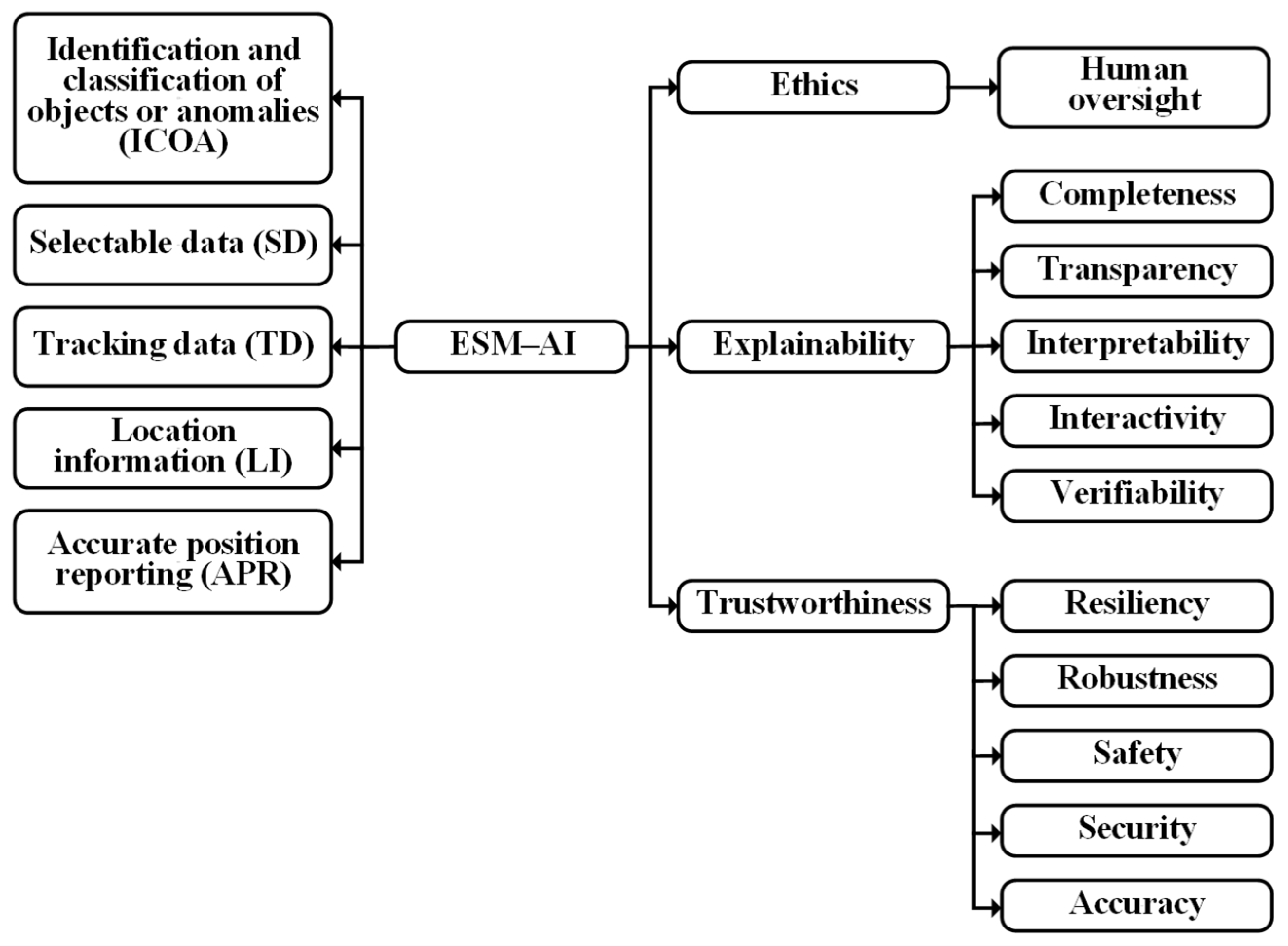
The key AI quality characteristics associated with the ESM task include:
- Accuracy, reflecting the correctness of detection and classification;
- Robustness, indicating the ability to operate under noise and uncertainty;
- Timeliness, representing the ability to process data in real time;
- Reliability, ensuring consistent performance over time.
These characteristics are essential for applications such as wildfire detection, radiation monitoring, and structural inspection, where incorrect or delayed information may lead to critical consequences.
The Situational Awareness (SA) task extends ESM’s capabilities by integrating data from multiple sources to form a coherent understanding of the operational environment. The taxonomy for SA is shown in Figure 2. This task includes:
- Monitoring of environmental conditions;
- Identification of hazards and changes in system state;
- Integration of data from multiple UAVs and sensors;
- Interpretation of operational context.
In particular, the SA task is decomposed into four subtasks, including Monitoring and Coordination of Field CBRNe Teams and mission Assets (MCFTA), Timely Informing about Hazards and Incidents (TIHI), Monitoring of the Overall Situation in the Operational environment (MOSO), and Situational Understanding of the Operational Environment (SUOE). These subtasks collectively define the capability of UAV systems to integrate heterogeneous data sources and support informed decision-making in complex civil missions. According to the authors of this study, the effective solution of the SA task depends on the ability to utilise a set of AI quality characteristics described in [51], which include properties related to explainability, trustworthiness, and ethical compliance of AI-enabled systems.
Figure 2.
Taxonomy of AI quality characteristics that affect the solution of the SA task for UAVs.
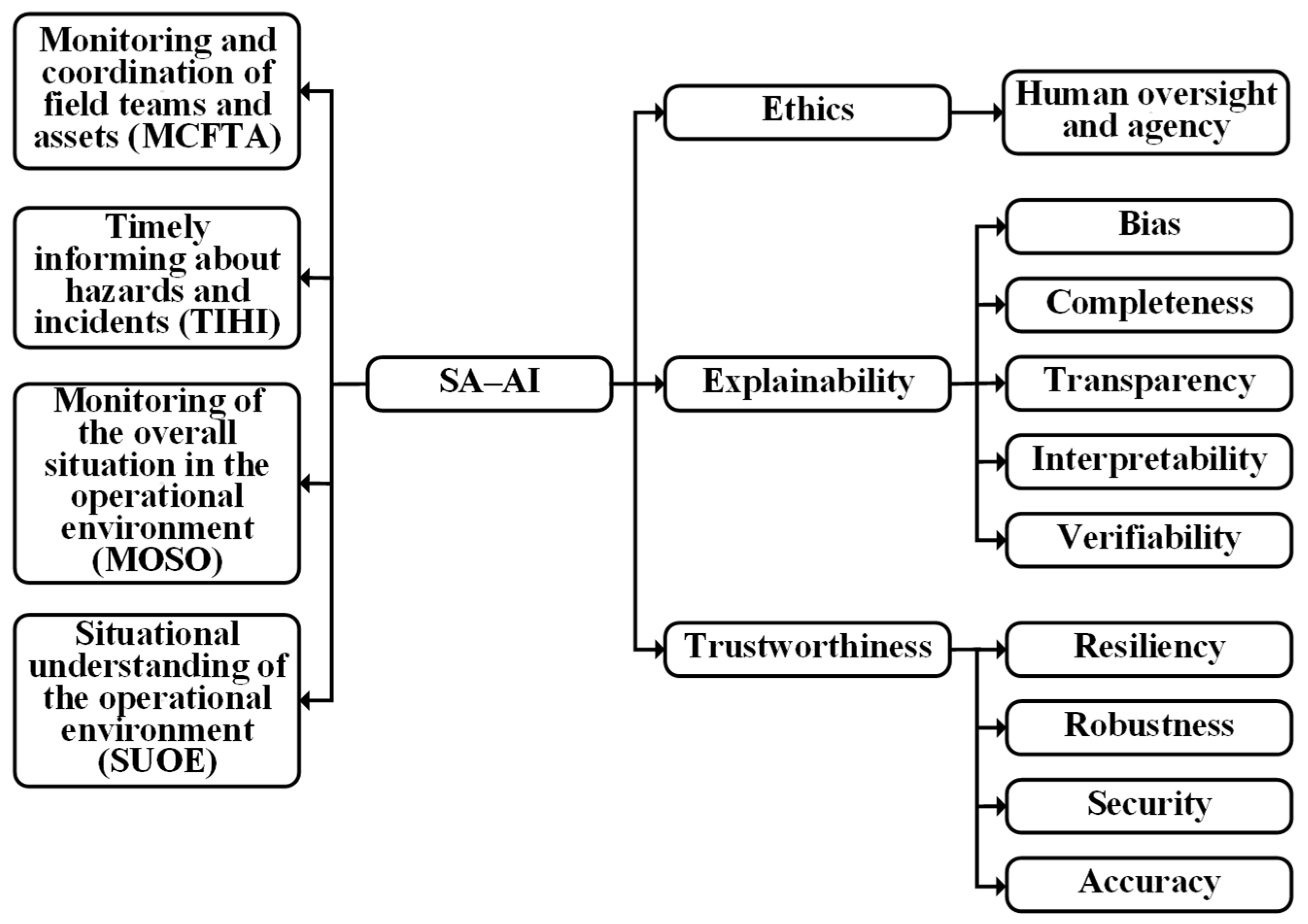
The primary AI quality characteristics for SA include:
- Consistency, ensuring agreement between multiple data sources;
- Interpretability, allowing human operators to understand system outputs;
- Adaptability, enabling response to changing conditions;
- Completeness, ensuring sufficient information coverage.
In civil scenarios, SA is critical for decision support, particularly in emergency response, where multiple UAVs must coordinate to provide a comprehensive view of the situation.
The Communication and Sensing Interference Resilience (CSIR) task assesses UAV systems’ ability to maintain operational functionality under degraded conditions. The taxonomy for CSIR is shown in Figure 3.
These conditions may arise due to:
- Communication signal loss or degradation;
- Environmental interference (e.g., smoke, radiation, and weather);
- Sensor noise or malfunction;
- Navigation uncertainty (e.g., GNSS denial).
In particular, the CSIR task is decomposed into four subtasks, including Evaluation of the Spatial Characteristics of interference-affected areas (ESC-IA), Evaluation of Directional Characteristics of interference propagation (EDC-IA), Evaluation and Control of Interference Intensity affecting navigation systems such as GNSS (ECII-GNSS), and Evaluation and Control of Interference Intensity affecting communication and telemetry links (ECII-TLC). These subtasks collectively define the capability of UAV systems to maintain stable operation under degraded communication and sensing conditions. According to the authors of this study, the effective solution to the CSIR task depends on the utilisation of AI quality characteristics described in [51], particularly resilience, fault tolerance, and robustness, which are essential for ensuring continuous operation in uncertain and interference-prone environments.
Figure 3.
Taxonomy of AI quality characteristics that affect the solution of the CSIR task for UAVs.
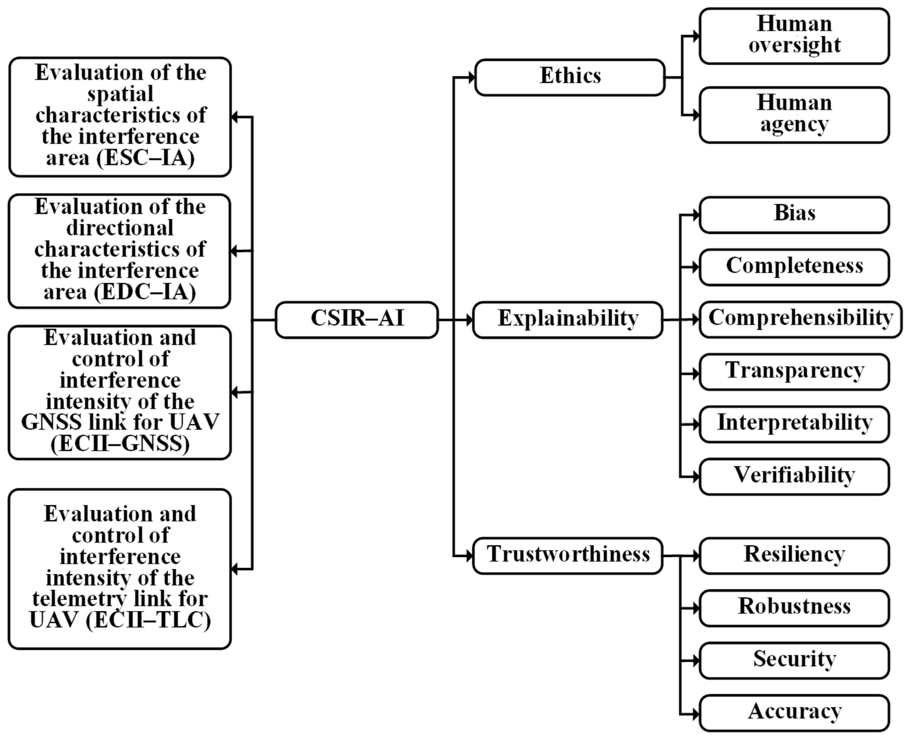
The primary AI quality characteristics for CSIR include:
- Resilience, reflecting the ability to continue operation under degraded conditions;
- Fault tolerance, enabling recovery from failures;
- Redundancy management, ensuring alternative pathways for communication or sensing;
- Stability, maintaining consistent system behaviour.
These properties are essential for UAV operation in disaster zones or industrial environments where infrastructure may be damaged.
The Hazard and Restricted-Zone Avoidance (HRZA) task focuses on safe navigation and mission planning in environments containing hazards or constraints. The taxonomy is presented in Figure 4.
This task includes:
- Identification of hazardous zones;
- Prediction of risk regions;
- Route planning under constraints;
- Avoidance of restricted or unsafe areas.
The HRZA task is decomposed into five subtasks: Simultaneous Coordination of Multiple UAVs in Constrained Airspace (SCMUA), Management of Intensive Environmental and Electromagnetic Disturbances (MIEED), Creation of a Shared Environmental Representation through Cooperative Sensing (CSER), Identification and Avoidance of Hazardous or Restricted Areas (IAHRA), and Planning and Calculation of Safe Flight Paths (PCSFP). Together, these subtasks define how UAV systems can ensure safe navigation and mission success in environments with spatial constraints and dynamic hazards. The authors state that effectively solving the HRZA task relies on AI quality traits from [51]: predictive accuracy, safety assurance, constraint handling, and decision reliability. These traits support safe, reliable navigation under complex operational conditions.
Figure 4.
Taxonomy of AI quality characteristics that affect the solution of the HRZA task for UAVs.
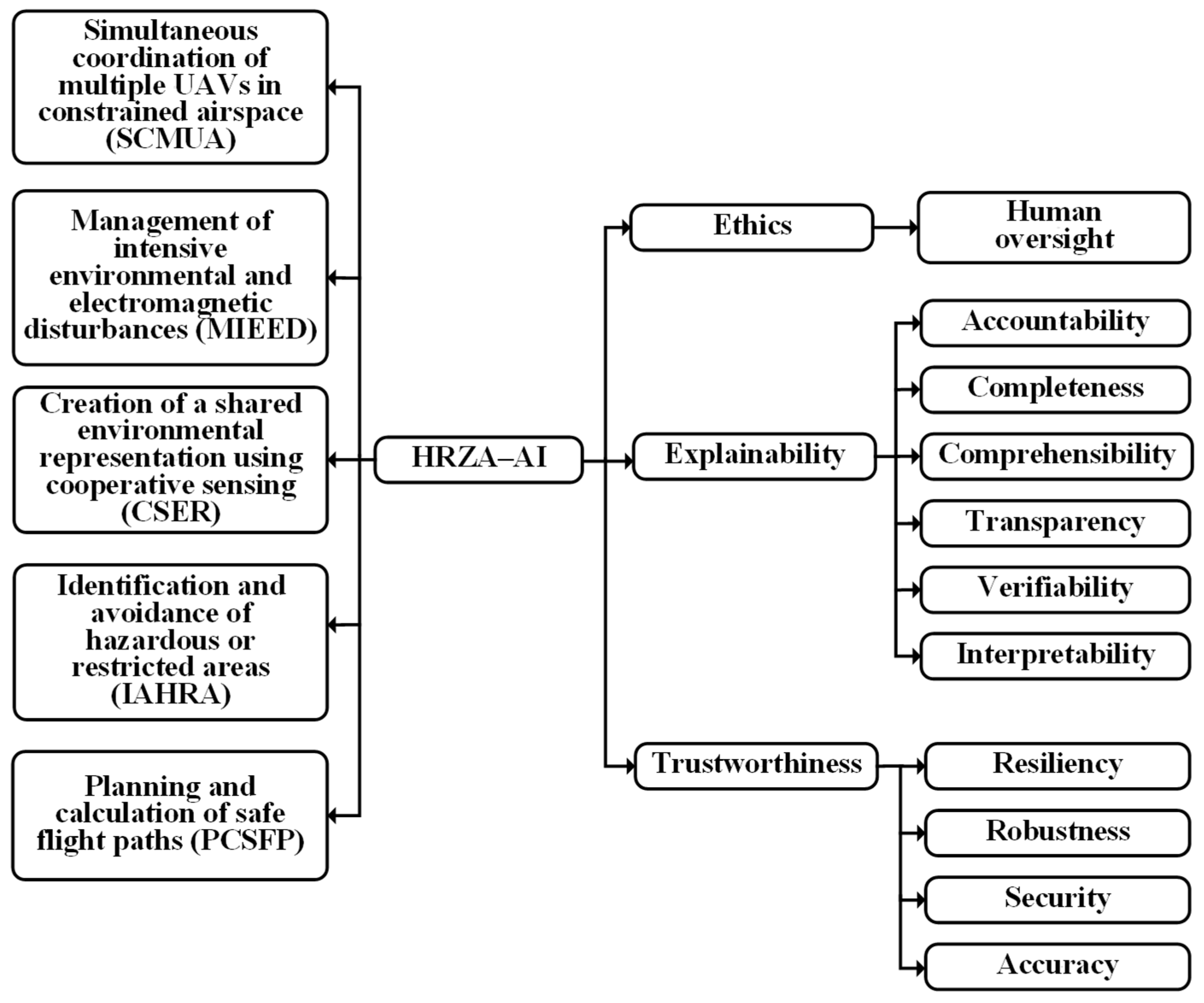
The primary AI quality characteristics for HRZA include:
- Predictive accuracy that affects the reliability of route planning by ensuring that predicted risk areas correspond to actual environmental conditions and constraints;
- Safety assurance that involves enforcing safety constraints through continuous monitoring and validation of planned and executed trajectories;
- Constraint handling refers to dynamic adaptation to no-fly zones, altitude restrictions, and mission-specific safety requirements;
- Decision reliability refers to the ability of the UAV to produce stable and repeatable actions under uncertainty or partial information.
These characteristics are critical for ensuring safe UAV operation in environments such as urban areas, industrial zones, or disaster-affected regions.
The Mission Execution and Intervention (MEI) task is the final stage of UAV operation, in which actions are performed based on the results of previous tasks. The taxonomy is shown in Figure 5.
This includes:
- Payload delivery (medical supplies, sensors, communication devices);
- Infrastructure inspection actions;
- Deployment of monitoring equipment;
- Support of emergency operations.
In particular, the MEI task is decomposed into five subtasks, including Receipt and Processing of Mission Designations (RPMD), Ensuring Accurate Delivery or Execution within Operational Constraints (EDEOC), Identification of Mission Objects or Intervention Points (IMOIP), Selection and Prioritisation of Mission Objectives (SPMO), and Execution of Intervention Actions or Payload Delivery (EIAPD). These subtasks collectively define the capability of UAV systems to perform mission-specific actions based on the outputs of preceding tasks. The MEI task is supported by AI components primarily at the stages of mission planning, mission object identification, and decision support. In contrast, the execution of mission actions is realised through conventional UAV control mechanisms. This interpretation is consistent with the modelling assumptions adopted for mission execution tasks, where AI components support decision-making and coordination processes. In contrast, the execution phase is modelled at the system level without explicit dependence on AI components.
Figure 5.
Taxonomy of AI quality characteristics that affect the solution of the MEI task for UAVs.
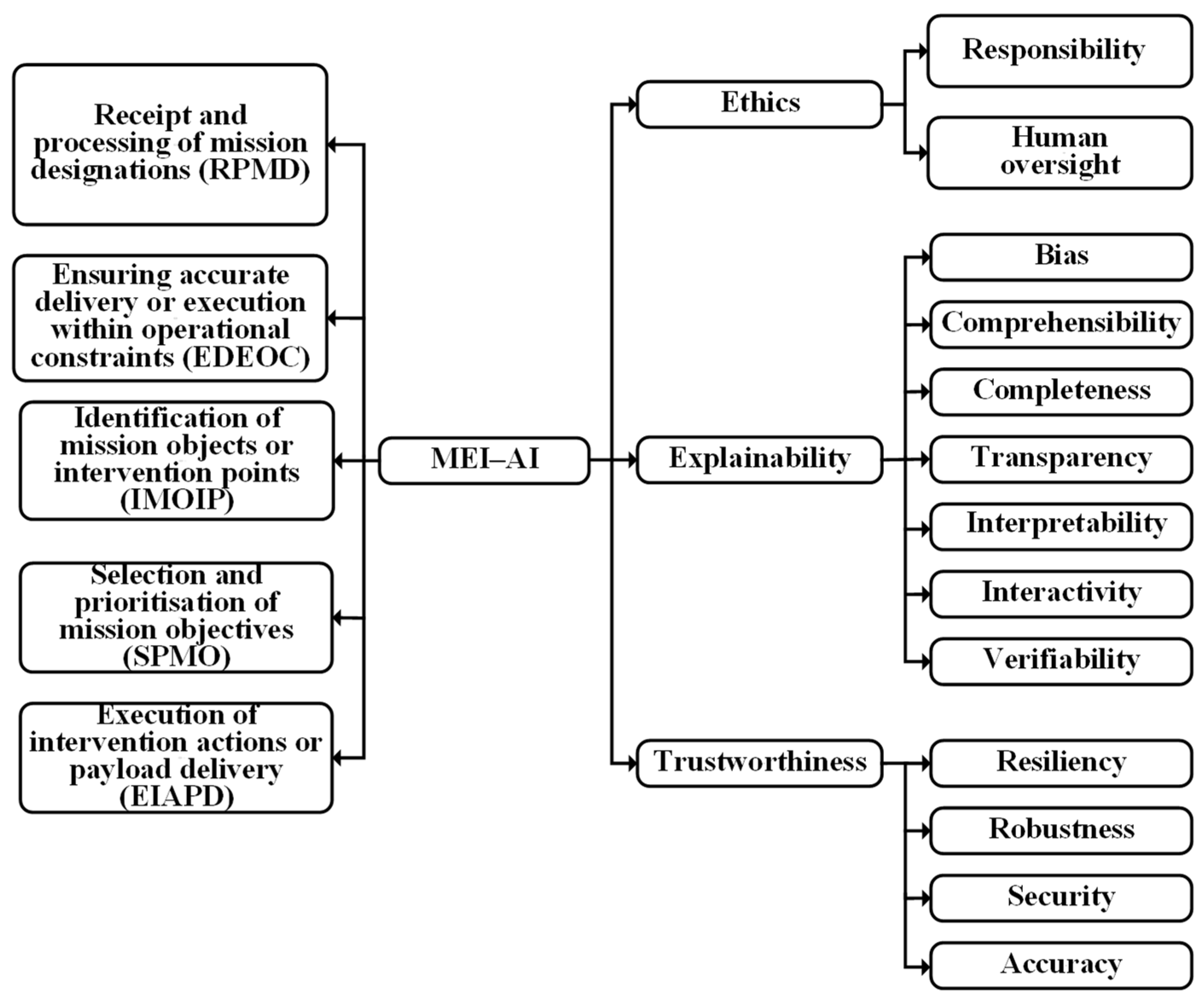
The key AI quality characteristics for MEI include:
- Execution reliability that reflects the robustness of control, coordination, and actuation processes required to achieve mission objectives under operational constraints;
- Coordination efficiency that directly impacts mission performance by reducing delays, conflicts, and redundant actions in multi-UAV scenarios;
- Timeliness, which is particularly critical in emergency scenarios where delays in intervention may significantly reduce mission effectiveness;
- Goal satisfaction provides a quantitative indicator of mission success, integrating both task completion and quality of execution.
3.3. Binary Set Description of UAV Mission Tasks and AI Components
Referring to Figure 1, Figure 2, Figure 3, Figure 4 and Figure 5, it should be noted that all components depicted in these taxonomy schemes are not independent but are interconnected through functional and logical relationships. These relationships reflect dependencies between mission subtasks, AI quality characteristics, and UAV operational modes. To formally represent and analyse these interactions, the proposed methodology uses the well-known theory of binary relations and sets [52], which enables the structured modelling of dependencies between system components and provides a mathematical basis for subsequent analysis of UAV mission effectiveness. This formalisation enables the consistent mapping between mission tasks and AI capabilities, which is essential for constructing hierarchical and probabilistic models presented in subsequent sections.
In the context of this work, several fundamental sets are introduced to represent the key elements of the UAV system. These include:
- Ai—sets of subtasks corresponding to mission tasks, where i = 1, …, 5 represents the following task categories: Environmental Sensing and Monitoring (ESM), Situational Awareness (SA), Communication and Sensing Interference Resilience (CSIR), Hazard and Restricted-Zone Avoidance (HRZA), and Mission Execution and Intervention (MEI);
- B—the set of AI utilisation approaches, including bottom-up and top-down approaches;
- F—the set of UAV operational modes, including autonomous and automatic modes;
- C, D, E—sets of AI quality characteristics grouped according to the taxonomy introduced in Section 3.2 (e.g., ethical properties, explainability, and trustworthiness).
Each mission task is decomposed into a set of subtasks, as described in Section 3.2. For example, the set A1, corresponding to the ESM task, includes subtasks such as detection, tracking, localisation, and reporting, while the set A5, corresponding to the MEI task, includes subtasks related to mission execution, coordination, and payload delivery. The complete definition of these sets, including their elements and corresponding labels, is summarised in Table 2.
Table 2.
Binary datasets for describing the operation modes of UAVs considering AI quality characteristics.
The symbolic elements in Table 2 should be interpreted as follows. The set A1 corresponds to ESM subfunctions: a11 = ICOA, a12 = SD, a13 = TD, a14 = LI, and a15 = APR. The set A2 corresponds to SA subfunctions: a21 = MCFTA, a22 = TIHI, a23 = MOSO, and a24 = SUOE. The set A3 corresponds to CSIR subfunctions: a31 = ESC-IA, a32 = EDC-IA, a33 = ECII-GNSS, and a34 = ECII-TLC. The set A4 corresponds to HRZA subfunctions: a41 = SCMUA, a42 = MIEED, a43 = CSER, a44 = IAHRA, and a45 = PCSFPa. The set A5 corresponds to MEI subfunctions: a51 = RPMD, a52 = EDEOC, a53 = IMOIP, a54 = SPMO, and a55 = EIAPD. The symbols b1 and b2 denote bottom-up and top-down AI utilisation approaches, respectively, while f1 and f2 denote autonomous and automatic UAV operation modes, respectively. The sets Ci, Di, and Ei denote ethics-related, explainability-related, and trustworthiness-related AI quality characteristics.
Based on these definitions, set-theoretical models are constructed to describe the relations among mission subtasks, UAV operational modes, AI utilisation approaches, and AI quality characteristics. E.g., the ESM subfunctions shown in Figure 1 are represented as A1 = {a11,a12,a13,a14,a15}, where a11 = ICOA, a12 = SD, a13 = TD, a14 = LI, and a15 = APR. According to Table 2, b1 denotes the bottom-up AI approach and b2 denotes the top-down AI approach, while f1 and f2 denote autonomous and automatic UAV operation modes, respectively. The remaining datasets Ci, Di, and Ei correspond to the AI quality characteristic groups shown in Figure 1, Figure 2, Figure 3, Figure 4 and Figure 5. The purpose of these binary relations is to generate ordered-pair mappings that can be used as structured requirements for AI-enabled UAV components in civil mission scenarios.
Following [50], two relations can be written for the first task (Figure 1). The first relation connects ESM subfunctions with the UAV operational mode: A1ρ1F1, where ρ1 = {(a11,f1),(a12,f1),(a13,f1),(a14,f1),(a15,f1)}. The second relation connects the UAV operational mode with the AI utilisation approach: F1σ1B1, where σ1 = {(f1,b1)}.
Next, consider the following definition.
Definition 1.
The composition of relations ρ and σ is called the relation σ1 ͦ ρ1, which is written as a set of ordered pairs a, c, such that a ∈ A, c ∈ C, and there exists an element b ∈ B, such that aσb ^ bσc.
In other words, the composition of these relations establishes the relation between ESM subfunctions and the AI utilisation approach in the following way:
Then, according to expression (1), the composition σ1 ͦ ρ1 establishes relations between ρ1 and σ1. This composition takes the form σ1 ͦ ρ1 = {(a11,b1),(a12,b1),(a13,b1),(a14,b1),(a15,b1)}. Let us write the obtained composition as ξ1 = σ1 ͦ ρ1. Simultaneously, consider a new relation δ1 among the datasets B1, C1, D1, E1 (Table 2), which researchers can write in the form of definite ordered pairs of data, given by the following expression δ1 = {(b1,c1),(b1,d1),(b1,d2),(b1,d3),(b1,d4),(b1,d5),(b1,e1),(b1,e2),(b1,e3),(b1,e4),(b1,e5)}.
Furthermore, they can find the next composition of the form ε1 = δ1 ͦ ξ1. The result of this combination of relations can be recorded in the form of 55 ordered pairs, which are presented in Table 3. With regard to the second task (Figure 2), researchers can consider two relations ρ2 and σ2. It means that they can write the relation A2ρ2F2, where ρ2 = {(a21,f2),(a22,f2),(a23,f2),(a24,f2)}, and the relation F2σ2B2, where σ2 = {(f2,b2)}. Next composition σ2 ͦ ρ2 establishes relations between ρ2 and σ2. This composition is written as ξ2 = σ2 ͦ ρ2, that is ξ2 = {(a21,b2),(a22,b2),(a23,b2),(a24,b2)}. The second relation might be written by researchers as δ2 = {(b2,c2),(b2,d1),(b2,d2),(b2,d3),(b2,d5),(b2,d6),(b2,e1),(b2,e2),(b2,e4),(b2,e5)}.
Table 3.
Binary computing results in the form of corresponding ordered pairs.
In the next step of binary computations, the composition of relations ε2 = δ2 ͦ ξ2 has been realised by researchers in the form of 40 ordered pairs, which are presented in Table 3. Accordingly, for the third task (Figure 3), the authors considered two relations ρ3 and σ3. Then, the relation can be expressed as the relations A3ρ3F3, where ρ3 = {(a31,f2),(a32,f2),(a33,f2),(a34,f2)}, and F3σ3B3, where σ3 = {(f2,b2)}. The subsequent binary computation steps for the third UAV task are performed analogously to those for the two previous tasks.
The overall results for all five tasks are presented in Table 3 as corresponding ordered pairs. In fact, the 268 combinations of ordered pairs of binary calculations (Table 3) can be used by researchers to formulate comprehensive requirements for AI components in a matrix form.
Table 3 presents a traceability matrix linking mission subtasks to AI quality requirements. Each ordered pair indicates that a given UAV subtask should be analysed, designed, or verified with respect to the corresponding AI quality characteristic, e.g., the ordered pair (a11,d1) means that the object identification and classification subtask must be considered against the corresponding explainability-related characteristic. Similarly, (a44,e4) links hazardous-area avoidance to the relevant trustworthiness characteristic. In engineering terms, the binary-relation layer can therefore be used to derive requirement checklists, verification criteria, and design constraints for AI-enabled UAV components. It is not introduced as an abstract mathematical exercise but as an intermediate representation that connects the task taxonomy in Figure 1, Figure 2, Figure 3, Figure 4 and Figure 5 with the hierarchical probabilistic model in Section 5.1. Thus, Figure 1, Figure 2, Figure 3, Figure 4 and Figure 5 should be interpreted as the graphical starting point of the formal modelling workflow. The task taxonomies shown in these figures define the mission-task elements that are subsequently encoded as the sets A, while the associated AI utilisation approaches, operational modes, and quality characteristics are encoded through the sets B, F, C, D, and E. Table 2 and Table 3 then convert the graphical taxonomies into formal binary-relation structures. These structures provide the requirement-level input for the architecture given in Section 4.1 and for the hierarchical modelling framework in Section 5.1.
4. Architecture and Hierarchical Modelling of the AI-Enabled UAV Systems
4.1. System Architecture for Perception, Recognition, and Guidance
The requirements derived in Section 3, and in particular the structured relationships between mission tasks, AI utilisation approaches, and AI quality characteristics formalised in Table 3, provide the basis for defining a functional architecture of an AI-enabled UAV system. This architecture is intended to support the execution of complex civil missions, including environmental monitoring, disaster response, infrastructure inspection, and operations in hazardous environments such as CBRNe scenarios. In these applications, UAVs must operate under uncertainty, limited situational awareness, and degraded communication conditions, necessitating the integration of adaptive AI components into both the perception and control loops.
Bearing these requirements in mind, Figure 6 presents the architecture of the perception, object-of-interest recognition, and mission-oriented guidance system [53]. In the proposed workflow, this architecture acts as the bridge between the task and quality models developed in Section 3 and the hierarchical modelling framework introduced in Section 4.2. Its components implement the main functional roles identified earlier: sensing and perception support ESM-related tasks; decision and prioritisation support SA; and mission management, guidance, and control support CSIR, HRZA, and MEI-related functions. The architecture is centred on heterogeneous sensor-data processing. A Modular Sensor Unit (MSU) integrates optical, thermal, radar-based, inertial, range, and environmental sensor inputs and transforms raw signals into digital data suitable for AI-enabled perception and subsequent control functions.
Figure 6.
Architecture of an AI-enabled UAV system for perception, object-of-interest recognition, and mission-oriented guidance in complex CBRNe operational environments.
The processed data are provided to two neural network estimator units (NNE-1 and NNE-2), which implement AI-based perception and recognition functions. These units are responsible for detecting and classifying objects or anomalies, extracting relevant features, and supporting higher-level decision-making processes. The use of neural network-based models, particularly Convolutional Neural Networks, is consistent with the approaches described in [26,27,28,45], in which deep learning techniques have demonstrated high effectiveness for tasks such as object detection and environmental monitoring. The separation into two estimator units reflects the distinction between real-time perception and knowledge-based interpretation. NNE-1 processes current sensor data streams, enabling immediate detection and classification of objects or environmental conditions. In contrast, NNE-2 operates on data retrieved from an onboard repository, the Mission Knowledge Base (MKB), which contains historical data, environmental models, and mission-specific constraints. This separation enables the integration of data-driven and knowledge-driven AI approaches, corresponding to the bottom-up and top-down paradigms introduced in Section 3.1.
The outputs of the estimator units are provided to a Selector Unit, which integrates and prioritises the information. The Selector Unit determines the relevance of detected objects or events based on both real-time observations and knowledge-base information. The decision-making logic implemented in the Selector Unit reflects the mapping between mission tasks and AI characteristics established in Section 3.3 and summarised in Table 3, particularly those related to accuracy, reliability, and interpretability.
The output of the Selector Unit feeds into the UAV system’s control loop. This loop includes the Navigation and Tracking Unit, the Flight Control Unit (FCU), the Sensor Unit (SU), the State Estimator (SE), the Electronic Stability Control (ESC) unit, and the propulsion subsystem. The State Estimator integrates information from multiple sources, including inertial measurement units, odometry cameras, and range sensors, enabling accurate estimation of the UAV state even in environments where GNSS signals are unreliable or unavailable. Visual-inertial odometry methods, as described in [54,55], play a key role in this process.
It should be noted that the architecture presented in Figure 6 is intended to illustrate the integration of AI components into UAV systems rather than to provide a complete implementation. It captures the essential interactions among perception, decision-making, and control components and provides a foundation for developing formal models of UAV behaviour. The authors use the proposed architecture to explain the principles of object-of-interest recognition and AI-enabled UAV operation. The improvement and technical implementation of the presented system are currently ongoing.
To improve the clarity of functional responsibilities and to ensure consistency between the architectural representation and the formal modelling framework introduced in Section 3, the proposed system is organised into a set of hierarchical functional layers. Such a layered architecture allows for distinguishing between the system’s conceptual functions and the heterogeneous software and hardware development. This layered decomposition reflects the separation of concerns between sensing, perception, decision-making, mission-level coordination, control execution, and physical actuation. The introduction of layers serves two primary purposes. First, it provides a structured interpretation of the interactions between system components depicted in Figure 6. Second, it establishes a direct correspondence between architectural elements and the modelling constructs defined earlier, including the task decomposition Ai, operational modes F, and AI utilisation approaches B.
The architecture is organised into six layers, described as follows:
- Layer 0: Input and sensing: This layer represents the external information sources and multi-modal sensor inputs, including optical, thermal, radar, inertial, range, and environmental sensors. It provides the raw data foundation for ESM-related tasks.
- Layer 1: Perception: This layer includes the Modular Sensor Unit and the neural network estimators NNE-1 and NNE-2. It transforms sensor data into object, anomaly, feature, and context information used by higher-level functions.
- Layer 2: Information fusion and decision: This layer includes the DPU, MKB, and UAV State Estimator. It combines perception outputs, contextual knowledge, and state information to support prioritisation, situational awareness, and degraded-information handling.
- Layer 3: Mission control: This layer is represented by the Mission Manager. It performs task sequencing, operational-mode selection, and coordination of mission constraints derived from the binary relations in Section 3.
- Layer 4: Guidance and control: This layer includes the Navigation and Task-Oriented Guidance Unit, FCU, and ESC. It translates mission-level decisions into navigation, trajectory, stabilisation, and control actions. This layer is closely associated with the Hazard and Restricted-Zone Avoidance (HRZA) task and aspects of CSIR, as it must maintain stable operation under uncertain, dynamically changing conditions.
- Layer 5: Actuation: This layer represents the physical execution of control commands and consists of the UAV propulsion system (motors). This layer converts electrical control signals into mechanical motion, enabling the UAV to realise the trajectories and actions defined by the control system. The separation of this layer from the control logic is essential for maintaining a clear distinction between computational processes and physical system behaviour. It provides the final stage in the control loop and directly influences the effectiveness of mission execution.
4.2. Hierarchical Modelling Framework
This subsection builds on the architecture in Figure 6 and introduces the hierarchical modelling framework used to analyse UAV performance at component, system, and mission levels. The framework is informed by hierarchical stochastic modelling for cloud systems [56], hierarchical reliability and availability modelling for cloud data-centre networks [32] and UAV path-planning research, which emphasises the need to model constrained and dynamically changing operational environments [57]. In the present paper, these ideas are adapted to AI-enabled UAV missions by combining component-level probabilistic dependencies, UAV-level logical dependencies, and mission-level execution constraints into a single analytical workflow.
The first layer represents AI-enabled components and is modelled using Bayesian Networks (BNs). In the proposed UAV context, BNs describe probabilistic dependencies among sensor inputs, neural network outputs, state estimation, object selection, guidance, and tracking. This use is consistent with prior work on probabilistic inference and causal modelling under uncertainty [58,59,60], as well as recent UAV-specific studies on accident-risk assessment and reliability-critical computation offloading [61,62]. When cyclic behaviour, availability, or degradation processes must be represented explicitly, complementary stochastic techniques such as Markov models, Semi-Markov models, and Stochastic Petri Nets may also be used [30,37].
The second layer represents the UAV as an integrated system of interacting subsystems. At this level, Fault Tree (FT) structures are used to capture logical dependencies and failure propagation among the functional elements abstracted from Figure 6 [30]. This layer links component-level probabilistic estimates with UAV-level system behaviour.
The third layer represents the mission or scenario level. It describes the operation of a coordinated group of UAVs in civil scenarios such as disaster response, infrastructure monitoring, or CBRNe assessment. At this level, mission-stage dependencies, resource constraints, environmental degradation, and communication limitations are represented using logical-probabilistic structures and Reliability Block Diagrams (RBDs) [30,31]. This allows lower-level components and UAV-level results to be propagated to the probability of mission completion. For example, MEI cannot be assessed independently of preceding ESM and SA stages, because intervention depends on prior sensing, localisation, and situational interpretation.
An important feature of the hierarchical framework is the explicit representation of dependencies between mission tasks. For example, mission execution and intervention tasks cannot be performed until environmental sensing and situational awareness tasks are completed. These dependencies are consistent with the task decomposition in Section 3 and are formally represented in the hierarchical model.
4.3. Theoretical-Set Description of Hierarchical Structure
To provide a formal representation of the hierarchical model, a set-theoretical description is introduced. This description extends the binary set framework presented in Section 3 and allows the integration of structural and probabilistic models within a unified mathematical formulation. The researchers can define a set of states for each obtained model, given the sequence of tasks solved by UAVs during the implementation of a specific scenario.
The following notation, which allows component-level AI performance, UAV-level system logic, and mission-level scenario execution to be represented within one hierarchical framework, is further used:
- Superscript (1) refers to the component level;
- Superscript (2) refers to the UAV system level;
- Superscript (3) refers to the scenario or mission level.
The sets S(1), L(1), and G(1) describe component-level system elements, tasks, and acyclic probabilistic graph structures.
The sets V(2), Y(2), and W(2) describe UAV-level entities, UAV-level tasks, and tree-like logical structures.
The function f(3) describes the mission-level logical-probabilistic structure.
The first layer of models will be defined on a subset of component parts of UAVs Sc ⊂ S(1), which solve a subset of tasks Lt ⊂ L(1). In a formalised manner, the proposed models can be represented as a subset of acyclic graphs Ga ⊂ G(1), where G(1) = M(1) × E(1), M(1) is the set of nodes of acyclic graphs, E(1) is the set of edges of acyclic graphs.
This results in the following equations:
Per Equations (2)–(4), different parts of UAVs can solve the same tasks, each described by the same acyclic graph. At the same time, the second layer of models is defined on a subset of separately taken UAVs Vu ⊂ V(2), which solve a subset of tasks Yt ⊂ Y(2), formally represented as a subset of tree-like structures Wi ⊂ W(2), where W(2) = N(2) × B(2), N(2) is the set of logical elements of tree-like structures, B(2) is the set of inputs and outputs of logical elements of tree-like structures.
As a result, this gives the following:
The authors of this paper analogously describe the third layer of models, which forms the top level of the hierarchical structure and is implemented for a specific scenario of a group (or swarm) of UAVs. In particular, the authors represent the third layer as a logical and probabilistic model of implementing a specific scenario and the corresponding structural scheme:
where r(3) are the elements of the scheme, d(3) are the connections between the elements of the scheme.
f(3) = r(3) × d(3),
The set-theoretical description can now be represented in tuple form. Given the relationships (Equations (2)–(7)), the proposed hierarchical model (HM) can be represented in the following form:
HM = {{S(1)}, {L(1)}, {G(1)}, {V(2)}, {Y(2)}, {W(2)}, f(3)}.
This formulation provides a unified representation of UAV system behaviour, integrating component-level probabilistic models, system-level logical models, and scenario-level structural models. The developed hierarchical model establishes the foundation for the quantitative assessment of UAV effectiveness, which is addressed in the next section through scenario-based mathematical modelling.
Further analysis will be conducted for a specific scenario involving UAVs operating in a group (or swarm). The proposed scenario will be developed through the stages of UAV application, assuming that ESM (Figure 1) tasks are solved using NNs as a key component of AI.
5. Assessment of the Effectiveness of AI-Enabled UAV Systems
In this section, the hierarchical framework developed in Section 4 is used to obtain a quantitative assessment of the effectiveness of AI-enabled UAV systems operating in a representative complex civil mission. The purpose of the analysis is to evaluate how the integration of AI components, operational modes, and mission task decomposition influences the overall probability of successful mission completion.
5.1. Development of Scenario-Based Models
The mathematical formulation is developed for a staged multi-UAV mission scenario and is based on the five mission task categories previously introduced, namely Environmental Sensing and Monitoring (ESM), Situational Awareness (SA), Communication and Sensing Interference Resilience (CSIR), Hazard and Restricted-Zone Avoidance (HRZA), and Mission Execution and Intervention (MEI). These task categories are treated as logically dependent mission stages, with successful execution determining the probability of mission completion. The mathematical modelling is performed using components of AI on board the UAV and under the following system of requirements and constraints that define admissible mission execution in terms of minimum acceptable success probability, mission time, resource allocation, and cost limits:
where is the minimum permissible probability of task completion by the group (or swarm) of UAVs;
T is the time of application of the UAVs according to their designation;
is the number of UAVs used at the ESM task;
is the number of UAVs used at the SA task;
is the number of UAVs used at the CSIR task;
is the number of UAVs used at the HRZA task;
is the number of UAVs used at the MEI task;
and are the minimum and maximum costs of completing the task by the group (or swarm) of UAVs.
To analyse mission effectiveness under these constraints, a representative civil scenario is introduced. The scenario is intended to reflect applications such as disaster response, critical infrastructure inspection, or CBRNe assessment, where UAVs must operate in a coordinated manner and where the sequence of mission stages is constrained by the logical dependencies between sensing, interpretation, resilience, safe navigation, and intervention.
The proposed scenario should be interpreted as a CBRNe-oriented mission-effectiveness model rather than as a physical hazard-dispersion or toxicological exposure model. The framework does not directly solve plume dispersion, dose accumulation, decontamination scheduling, or sensor-contamination physics. Instead, these factors are represented as scenario constraints and degradation drivers that influence the probabilities assigned to ESM, SA, CSIR, HRZA, and MEI. This modelling choice is appropriate for the present paper because the objective is to evaluate how AI-enabled UAV task performance propagates to mission-level success, not to replace specialised CBRNe dispersion or consequence-analysis tools. The CBRNe-specific factors considered at the scenario level are summarised in Table 4.
Table 4.
CBRNe-specific constraints and their representation in the proposed mission-effectiveness model.
The use of a CBRNe-oriented civil scenario is also consistent with recent UAV literature on emergency and disaster-response applications. UAVs have been discussed as tools for real-time monitoring, medical logistics, hazardous-zone assessment, and support in CBRNe threat scenarios, where reducing human exposure is a key operational objective [63].
Thus, the proposed model can use outputs from specialised CBRNe hazard-assessment tools as input parameters, but it does not attempt to reproduce those tools internally.
Figure 7 shows the proposed scenario for UAV actions. According to the given scenario, it is proposed that during the upcoming mission, the UAVs will solve a common task in four stages. Specifically, at the first stage, one UAV performs the ESM task. This includes sensing, detection, localisation, and tracking of mission-relevant objects, anomalies, or hazardous environmental features. The scenario in Figure 7 is used as an analytical case study. It represents a coordinated UAV response to a CBRNe-relevant civil incident in which an affected area must first be sensed and localised, then interpreted at the situational-awareness level, then assessed under degraded sensing or communication conditions, and finally supported through intervention or payload delivery. Its purpose is to demonstrate how the proposed modelling workflow connects task decomposition, AI-enabled perception, mission-stage dependencies, and mission-completion probability. This staged interpretation is consistent with recent multi-UAV mission-planning research, where mission execution is formulated as a constrained planning problem involving task assignment, temporal dependencies, UAV capability matching, and coordination among multiple aerial platforms [64].
Figure 7.
Proposed scenario for a coordinated CBRNe UAV mission involving ESM, SA, CSIR, and MEI stages.
At the second stage, one UAV, or an equivalent logical subsystem operating within the same platform, performs the SA task by integrating the acquired data into a coherent operational picture. (Figure 2). If necessary, during the SA stage, the same specialised UAV is used to control several units on the mission. In addition, it is expected that the UAV could operate under harsh conditions, such as high radiation or Electromagnetic Interference (EMI).
At the third stage, a group of UAVs equipped with relevant sensing and communication capabilities evaluates the degree of degradation affecting sensing and communication, thereby supporting the CSIR task (Figure 3). These three UAVs, operating from different directions and altitudes, will enable assessment of the size of the CSIR zone and the possibilities for overcoming it. At the fourth and final stage, four UAVs execute the MEI task (Figure 5), which may include payload delivery, sensor deployment, relay support, or mission-specific intervention. The importance of this stage is reinforced by recent research on UAV communications. Studies on 5G-and-beyond UAV networks show that aerial connectivity, deployment scenarios, regulatory constraints, and emerging communication technologies are central to scalable UAV operation [65]. Under degraded or adversarial communication conditions, hybrid approaches combining deep neural networks and machine-learning algorithms have been proposed for reliable jamming identification in UAV communications [66]. In addition, UAV swarm communication reliability has been modelled using comprehensive signal-to-interference-and-noise ratio formulations that account for fading, line-of-sight probability, physical environment, and interference from UAVs and ground control stations [67].
The scenario shown in Figure 7 is treated as a sequential mission chain at the level of mission stages. Therefore, mission completion requires the successful execution of the critical ESM, SA, CSIR, and MEI stages within the admissible limits defined by criterion (8). Under this interpretation, mission non-completion occurs if at least one critical mission stage fails. Hence, the event of mission non-completion is represented as the union of stage-level failure events, not as the intersection of all individual failures. Intersections are used only inside redundant UAV groups, where a stage fails only if all UAVs assigned to that redundant stage fail.
The scenario presented in Figure 7 corresponds to a logical and probabilistic model that the authors developed, based on the analysis of a specific sequence of events and the causal relationships between them. Therefore, according to criterion (8), the probability of task completion by the group (or swarm) of UAVs can be determined as follows:
where P{Φ(X) = 0} is the probability of mission non-completion by the UAV group or swarm.
is the probability of non-completion of the ESM task by the UAV equipped with AI components.
is the probability of non-completion of the SA task with AI components.
is the probability of non-completion of the CSIR task by the i-th UAV involved in resilience support and equipped with AI components, where i = 1, 2, 3.
is the probability of non-completion of MEI task by the j-th UAV assigned to task execution without AI components, where j = 1, 2, 3, 4.
The transition from the graphical mission scenario to the formal model is performed by treating each mission stage in Figure 7 as a logical event whose successful or unsuccessful completion contributes to the mission-level probability model. Figure 8 shows the hierarchical representation corresponding to Equations (8) and (9). Each of the three layers of the hierarchical model considered (Figure 8) corresponds to a formalised description and its mathematical representation in the form of Equations (2)–(7), which are presented in Section 4.3.
Figure 8.
Hierarchical modelling framework for AI-enabled UAV systems (BN–FT–RBD), aligned with the functional architecture (Figure 6) and mission tasks ESM, SA, CSIR, HRZA, and MEI.
In this representation, the first layer corresponds to component-level probabilistic models, the second to system-level logical dependencies, and the third to scenario-level mission execution. The hierarchical model, therefore, provides the structural basis for propagating subsystem-level performance estimates to the mission level.
At the same time, the authors recognise that a full-scale simultaneous modelling of all three layers of the developed scenario shown in Figure 7 constitutes a non-trivial task that requires a comprehensive and systematic treatment. The complexity arises from the need to combine, within a single analytical framework, component-level probabilistic dependencies, UAV-level structural logic, and mission-level scenario execution under external operational constraints. For this reason, the proposed analysis is carried out in stages, preserving the coherence of the hierarchical model while keeping the resulting quantitative assessment analytically tractable.
Accordingly, the authors adopt the following assumptions for the first stage of the analysis:
- It is assumed that the timely and correct execution of the ESM task shown in Figure 1 has a decisive influence on the success of the mission as a whole. This assumption is justified because the subsequent stages depend on reliable sensing, localisation, and tracking results from the entry stage. Therefore, the ESM task is evaluated explicitly on the basis of mathematical modelling.
- It is further assumed that the probability indicators associated with the successful execution of the remaining mission tasks are introduced in the form of expert estimates, that is, as fixed quantitative assessments used at this stage of the study as input parameters for the higher layers of the hierarchical model. Such an assumption does not eliminate the possibility of future refinement; rather, it enables the present work to focus on the structured propagation of subsystem-level performance toward mission-level effectiveness without requiring full experimental calibration of all task stages.
Because of these assumptions, the first layer of the hierarchical model is analysed by obtaining a probabilistic assessment of the localisation and tracking processes associated with the ESM task. In this way, the proposed step-by-step approach preserves the integrity of the overall hierarchical formulation while providing a clear analytical entry point for quantitatively evaluating AI-enabled UAV performance in complex civil missions.
To ensure consistency between the functional architecture and the analytical modelling framework, a direct correspondence is established between the six layers of the UAV system architecture presented in Figure 6 and the three layers of the hierarchical model shown in Figure 8. The two representations describe the same system at different levels of abstraction: Figure 6 provides a detailed functional decomposition, whereas Figure 8 provides an analytical representation suitable for probabilistic and structural modelling. The correspondence between these layers is defined as follows:
- Layers 0–1 of Figure 6 → Layer 1 of Figure 8. The sensing/input and perception layers, including multi-modal sensors, the MSU, NNE-1, NNE-2, and initial state-estimation inputs, are represented at the component level using Bayesian Networks. At this level, sensing quality, neural network recognition, contextual interpretation, and state estimation are treated as probabilistic variables that influence ESM-stage success.
- Layers 2–4 of Figure 6 → Layer 2 of Figure 8. The information-fusion, decision, mission-control, guidance, and control layers, including the DPU, MKB, Mission Manager, Navigation and Task-Oriented Guidance Unit, FCU, and ESC, are abstracted into UAV-level logical dependencies. These dependencies describe how perception and decision outputs are transformed into guidance, control, and stability functions.
- Layer 5 of Figure 6 and the integrated UAV system → Layer 3 of Figure 8. The actuation layer and the UAV as an integrated operational unit contribute to mission-level scenario execution. At this level, RBD-based and logical-probabilistic structures represent the success or failure of mission stages such as ESM, SA, CSIR, HRZA, and MEI.
- The complete UAV system, including all layers of Figure 6, is represented in Figure 8 at the highest level by the mission execution Layer 3. This layer is typically modelled using Reliability Block Diagrams (RBDs) or scenario-based structures. At this level, the system is analysed in terms of mission-stage success probabilities, including ESM, SA, CSIR, HRZA, and MEI. Thus, the entire architecture of Figure 6 is abstracted into a mission-level probabilistic model in Figure 8.
Based on the assumptions introduced above, the first stage of the hierarchical model is evaluated by obtaining probabilistic assessments of the localisation and tracking processes for the Environmental Sensing and Monitoring (ESM) task. At this level, the main analytical objective is to determine how the perception subsystem’s performance affects the probability of successfully executing the mission’s entry stage. In the proposed framework, this is achieved with a Bayesian Network (BN). The BN captures probabilistic dependencies among neural network-based recognition, state estimation, object-of-interest selection, guidance, and tracking.
At the first layer of the hierarchical model, the ESM-related part of Figure 6 is formalised as a BN. In this transformation, NNE-1, NNE-2, the State Estimator, object selection, guidance, and tracking functions become random variables or conditional events in the BN structure. Figure 9 shows the directed acyclic graph (DAG) of this BN model. It is supplemented with a list of conditional probability tables (CPTs). The graph formalises the causal structure of the ESM-stage perception subsystem and provides the basis for computing the probability of successful localisation and tracking. In this representation, the BN does not model a target chain. Instead, it models the perception and decision logic needed to detect, interpret, and track an object, anomaly, or mission-relevant environmental feature under uncertain sensing conditions.
Figure 9.
A directed acyclic graph for the BN that is used to describe the processes of object localisation and tracking.
Before obtaining the required probabilistic assessment, it is appropriate to restate the general definition of the BN in a form consistent with the present modelling context.
Definition 2.
A BN is a probabilistic model represented as a directed acyclic graph (DAG) in which each node corresponds to a random variable associated with the analysed process.
The edges of the graph represent conditional dependencies between the nodes and enable the factorisation of the joint probability distribution according to parent–child relationships. In the present study, the BN is used to model dependencies between neural estimators, state estimation, object selection, guidance, and tracking during the ESM stage. This interpretation is fully consistent with the use of Bayesian methods for probabilistic reasoning in uncertain systems discussed in [57,58,59]:
Following Equation (10), and considering the DAG shown in Figure 9 together with the CPTs and marginal distributions, the joint probability distribution of the variables involved in the ESM-stage localisation and tracking process can be written in the following form:
where p(nn1) = P{NNE-1 = nn1} denotes the probability that the first neural network estimator correctly detects or classifies an object of interest based on current sensory inputs S1, S2, S3.
p(nn2) = P{NNE-2 = nn2} denotes the probability that the second neural network estimator performs correct contextual interpretation or recognition using data retrieved from the Mission Knowledge Base.
p(sest) = P{State Estimation} denotes the probability that the UAV state is correctly estimated based on inputs from the odometry camera, laser rangefinder, and inertial measurement unit.
p(trk|gdn) represents the probability of successful tracking given successful guidance/localisation.
p(trg|slc, sest) represents the probability of successful guidance given the selection of the mission-relevant object and correct state estimation.
p(slc|nn1,nn2) represents the probability of successful object selection and prioritisation given the outputs of the two neural estimators.
Using Equations (10) and (11), the marginal probability of successful object-of-interest tracking can be obtained. In the present framework, this marginal probability quantifies the ESM-AI subsystem’s capacity to autonomously solve the perception and localisation task under uncertain sensing conditions.
Below are the expressions, the sequential use of which allows researchers to determine the value of the desired probability, namely
where
The sequential use of Equations (12)–(16) enables the determination of the desired probability of successful localisation and tracking at the ESM stage. In analytical terms, these expressions represent the propagation of uncertainty from sensor-driven neural estimation and contextual interpretation through the state-estimation and guidance chain toward the final tracking event. This probabilistic result serves as the first-layer input to the remaining levels of the hierarchical model.
The BN in Figure 9 represents the perception-to-guidance chain for one analytical decision cycle. It accounts for the effect of perception quality on object selection, guidance/localisation, and tracking through the dependencies NNE-1, NNE-2, Sest, slc, gdn, and trk. However, the present static BN does not explicitly represent a recursive feedback loop in which poor perception leads to a hazardous navigation command, changes the UAV pose or trajectory, and consequently degrades subsequent sensor observations. Such a feedback mechanism would introduce temporal and cyclic dependencies that are outside the scope of the acyclic BN used in this paper. For this reason, the current model should be interpreted as a first-stage probabilistic propagation model, not as a full closed-loop control model. A more detailed implementation could extend Figure 9 into a dynamic Bayesian Network or a hybrid BN–Markov model with time-indexed variables St, Sestt, gdnt, trkt, and St+k, where the next sensing state depends on the previously executed guidance action.
To support reproducibility, the computational procedure used for the scenario-based assessment is specified as follows:
- First, the BN structure in Figure 9 defines the dependencies among NNE-1, NNE-2, Sest, slc, gdn, and trk;
- Second, the marginal input probabilities P(NNE-1), P(NNE-2), and P(Sest) are varied according to the values reported in Table 5;Table 5. The generalised modelling results for assessing the probability of successful localisation and tracking at the ESM stage.
- Third, Equations (10)–(16) are used to compute the ESM-stage probability of successful localisation and tracking;
- Fourth, the resulting ESM probabilities are propagated to the mission-level model using Equation (17), together with the degradation-dependent CSIR and MEI intervals reported in Section 5.3;
- Fifth, lower and upper mission-completion probabilities are obtained by evaluating Equation (17) at the lower and upper bounds of the corresponding intervals.
The full numerical conditional probability tables used for the BN calculations, together with the scenario-generation rules and a script for reproducing, are described further.
The scenario-generation and probability-propagation algorithm is the following:
- Define the mission scenario as a sequence of ESM, SA, CSIR, and MEI stages according to Figure 7;
- Select P(NNE-1), P(NNE-2), and P(Sest) from the interval 0.90–0.95;
- Use the BN structure in Figure 9 and Equations (10)–(16) to compute the ESM-stage localisation and tracking probability;
- Assign PESMP and PSA according to the ESM baseline used in the scenario;
- Select the degradation level: low or moderate;
- Assign and from the degradation-dependent intervals defined for the selected mission-level scenario;
- Compute the mission-completion probability using Equation (17);
- Repeat Steps 2–7 for the lower and upper bounds of the selected intervals to obtain the sensitivity ranges used in the mission-level analysis.
This procedure establishes the complete traceability chain from the graphical models to the numerical results: Figure 1, Figure 2, Figure 3, Figure 4 and Figure 5 define the task and quality structures, Figure 6 provides the functional architecture, Figure 8 defines the hierarchical abstraction, Figure 9 provides the BN structure for ESM-stage calculation, and Figure 7 defines the mission-stage sequence used for mission-level probability propagation.
5.2. Laboratory-Scale Experimental Support for ESM-Stage Sensor-Data Processing
To experimentally support the proposed modelling framework of UAVs with AI, a laboratory-scale experiment was conducted for the ESM-stage sensor-data processing chain. The experiment focused on heading data acquisition and processing using a QMC5883L three-axis anisotropic magnetoresistive (AMR) sensor. In the proposed architecture, this sensor is interpreted as part of the Modular Sensor Unit (MSU) shown in Figure 6 and provides heading-related input data for state estimation and localisation under GNSS-degraded or GNSS-denied conditions. The QMC5883L 3-axis magnetoresistive sensors in the Land Grid Array package (LGA 3 × 3 × 0.9 mm3) operate over the temperature range −40 to +85 °C, in a wide magnetic field range (±8 Gauss), with an operating voltage from 2.16 V to 3.6 V, and at low power consumption (75 µA). These sensors are integrated into the MSU to determine the projection of the full vector of the Earth’s magnetic field onto a horizontal surface; i.e., they serve as an electronic magnetic compass, keeping the UAV on course in the absence of GNSS operation. Naturally, when using the AMP sensor as part of the MSU, its orientation is tied to the inertial geocentric coordinate system (the X axis is directed to the vernal equinox point, the Z axis is directed along the Earth’s rotation axis, and the Y axis creates a right coordinate trihedron with the X and Z axes). This choice is consistent with the role of the MSU in Figure 6, since heading stabilisation and state-estimation inputs are essential for maintaining perception, localisation, and tracking functions during the ESM stage.
The QMC5883L sensor was selected because it can operate as an electronic magnetic compass and provide heading measurements relevant to UAV navigation and state estimation. The experiment was conducted under a fixed commanded heading, while raw sensor outputs were recorded after 5, 20, and 35 min of operation. The purpose of the experiment was not to reproduce a complete CBRNe mission, but to evaluate whether the sensor-data processing chain associated with the ESM-stage Bayesian Network in Figure 9 can reduce heading-data degradation caused by sensor drift and external magnetic-field effects.
Figure 10a–c shows the raw heading-data behaviour of the QMC5883L sensor after 5, 20, and 35 min of operation. The experimental curves indicate that the raw heading output becomes less stable after approximately 15–20 min of operation. This behaviour is consistent with the expected influence of external magnetic fields on AMR sensors, even when temperature compensation and Wheatstone-bridge-based sensing elements are used. Such degradation is relevant to the proposed UAV model because corrupted heading information can reduce the quality of state estimation, object localisation, guidance, and tracking during the ESM stage.
Figure 10.
(a) Raw heading outputs from the QMC5883L AMR sensor after 5 min of operation under a fixed commanded heading. (b) Raw heading outputs from the QMC5883L AMR sensor after 20 min of operation under a fixed commanded heading. (c) Raw heading outputs from the QMC5883L AMR sensor after 35 min of operation under a fixed commanded heading.
The same sensor output data were then processed using the BN-based estimation logic shown in Figure 9. The processing aimed to obtain probabilistic estimates of localisation and tracking and to filter inconsistent heading data. Figure 11 shows the heading-output behaviour after BN-based processing for the 35 min case. The processed output remains close to the commanded heading and, in the conducted laboratory experiment, the heading error did not exceed 1°. This result provides laboratory-scale support for the use of BN-based processing in the ESM-stage perception and state-estimation chain.
Figure 11.
Heading data from the QMC5883L AMR sensor after 35 min of operation, after BN-based processing associated with the ESM-stage localisation and tracking model.
The experiment was conducted as a part of component-level laboratory validation rather than full UAV flight validation. It confirms that the proposed BN-based ESM-stage processing can improve the robustness of heading-related sensor data used by the MSU and state-estimation chain. However, it does not validate the complete multi-UAV mission scenario, the CBRNe mission assumptions, or the mission-level probabilities used in Equation (17). These aspects require future integrated UAV experiments and mission-level flight trials.
5.3. Simulation Results
Using Equations (10)–(16), the first-layer mathematical modelling was performed by varying the marginal probabilities P(Sest), P(NNE-1), and P(NNE-2) within the interval 0.90–0.95. This interval should be interpreted as a parametric design-space assumption for a high-performance AI-enabled perception subsystem.
MATLAB (v2024) was used as the modelling environment. This is because the specified software platform significantly expands research capabilities through a highly developed, user-friendly, and powerful toolkit for object-oriented modelling, convenient tools for graphical visualisation of results, and versatile libraries for implementing and analysing simulated processes. In accordance with [45], a CNN was used for NNE-1 and NNE-2 detection and primary classification based on data obtained from UAV sensors. Therefore, the YOLOv5s CNN was employed to provide high-speed, high-quality processing of sensor data in real time.
The laboratory-scale experiment reported in Section 5.2 provides component-level support for the ESM-stage sensor-data processing chain, showing that BN-based processing can reduce heading-data degradation in AMR sensor outputs. However, the interval 0.90–0.95 is still not claimed as a fully calibrated probability range for all UAV sensors or all CBRNe mission conditions. Full calibration of these probabilities requires broader sensor-specific error models, environmental test data, and integrated UAV flight validation. The quantitative results of this modelling stage are shown in Figure 12, Figure 13 and Figure 14 and summarised in Table 5.
Figure 12.
(a) Mathematical modelling results for P(Sest) = P(NNE-1) = P(NNE-2) = 0.9. (b) Mathematical modelling results for P(Sest) = P(NNE-1) = P(NNE-2) = 0.91.
Figure 13.
(a) Mathematical modelling results for P(Sest) = P(NNE-1) = P(NNE-2) = 0.92. (b) Mathematical modelling results for P(Sest) = P(NNE-1) = P(NNE-2) = 0.93.
Figure 14.
(a) Mathematical modelling results for P(Sest) = P(NNE-1) = P(NNE-2) = 0.94. (b) Mathematical modelling results for P(Sest) = P(NNE-1) = P(NNE-2) = 0.95.
In accordance with Figure 8, the overall probability of successful completion of the ESM stage may be interpreted as the product of the probabilities associated with four constituent functional processes:
- (a)
- Object localisation and tracking;
- (b)
- Flight control;
- (c)
- Electronic stability control;
- (d)
- Movement execution.
At the same time, it should be emphasised that the effectiveness of the ESM stage is determined not only by these subsystem-level probabilities, but also by the AI quality characteristics [49] identified in Figure 1 and discussed in Section 3.2, especially accuracy, robustness, timeliness, and reliability.
The results from Table 5 are then used as input to model the second and third layers of the hierarchical structure shown in Figure 8. For this purpose, the following assumptions are introduced:
- (i)
- It is assumed that the probability values associated with the Flight Control Unit, Sensor Unit, State Estimator, and Electronic Stability Control subsystem are not lower than the probability obtained for the object localisation and tracking process at the ESM stage;
- (ii)
- The probabilities of successful completion of the SA-AI, CSIR-AI, HRZA-AI, and MEI-AI stages are introduced as fixed values or expert-defined estimates;
- (iii)
- The probabilities associated with the CSIR and MEI stages are analysed under different levels of environmental and communication degradation (low, moderate, and high intensity), since these stages are most directly affected by external operational conditions.
The operational capability of the CSIR and MEI UAV groups should therefore be analysed with respect to low, moderate, and high levels of environmental and communication degradation. Table 6 shows the analysis of the capabilities of CSIR and MEI UAV groups. Under low degradation, UAVs can perform their intended roles without substantial restrictions. Under moderate degradation, operation remains feasible, but with reduced effectiveness and a narrower feasible set of trajectories or communication channels. Under high degradation, sustained mission execution may become infeasible.
Table 6.
Analysis of the capabilities of CSIR and MEI UAV groups under different levels of environmental and communication degradation.
Using the assumptions formulated above, mission-level modelling was performed for the scenario shown in Figure 7 under low- and moderate-degradation conditions.
The probability of successful mission completion for the UAV (or swarm) can then be determined using the logical-probabilistic model (9) corresponding to criterion (8) and the scenario logic in Figure 7 as follows:
where is the probability of ESM task completion by the UAV with AI components.
is the probability of SA task completion by the UAV with AI components.
is the probability of CSIR task completion by the UAV with AI components, where i = 1, 2, 3.
is the probability of MEI task completion by the UAV without AI components, where j = 1, 2, 3, 4.
Equation (17) represents a conservative logical-probabilistic abstraction of a small and coordinated UAV group. It assumes that the UAVs assigned to CSIR and MEI contribute through parallel mission-stage success terms and that their failures can be treated as conditionally independent within the selected degradation level. This is acceptable for the illustrative scenario in Figure 7, where UAVs operate from different directions or altitudes and perform separable sensing, resilience support, or intervention roles. However, larger UAV swarms may exhibit non-linear failure propagation. Examples include communication-topology collapse, consensus instability, collision or deconfliction constraints, shared localisation errors, correlated environmental exposure, and resource contention. In such cases, adding more UAVs may not produce a proportional increase in mission success; it may even introduce cascading dependencies. For true swarm intelligence scenarios, the CSIR and MEI terms in Equation (17) should therefore be replaced with swarm-level effectiveness functions that explicitly account for topology, task allocation, inter-UAV communication, correlated failures, and coordination overhead.
To improve the transparency of the mission-level parameters used in Equation (17), the expert-defined probabilities for the later mission stages are interpreted as interval estimates rather than as exact validated performance values. The purpose of these estimates is not to claim experimentally measured performance but to provide admissible input ranges for scenario-level propagation. The estimates are assigned according to the operational role of each mission stage, the expected degradation level, the dependence on earlier sensing outputs, and the feasibility of task execution under CBRNe-related environmental and communication constraints. Table 7 summarises the criteria used for assigning these values.
Table 7.
Criteria used for expert-defined mission-stage probability estimates.
This future extension should also explicitly consider collision avoidance and collaborative intelligence. Recent work on UAV swarm collision avoidance emphasises that scalable swarm deployment in mission-critical domains requires learning-enabled coordination, real-time decision-making, communication-aware interaction, and safety assurance mechanisms [68].
The interpretation limitation of the HRZA mission stage in Table 7 is particularly important, as HRZA is closely related to UAV path planning in complex, constrained environments. Recent path-planning surveys show that UAV navigation requires integrating sampling-based, potential-field, bio-inspired, mathematical, and artificial intelligence-based methods, depending on mission constraints, obstacle structure, and environmental uncertainty [69].
The corresponding initial data are provided in Table 8. The ESM-stage values are taken from the BN-based localisation and tracking results in Table 5, while the CSIR and MEI intervals reflect the degradation-dependent assumptions justified in Table 6 and Table 7. In this way, the model captures both the internal structural quality of the ESM subsystem and the external operational disturbances affecting later mission stages.
Table 8.
Initial data for mission-level modelling under low and moderate environmental and communication degradation.
The modelling results obtained from Equation (17) for the initial data of Table 8 are presented in Figure 15, Figure 16 and Figure 17. These results show how the mission-level success probability varies across three ESM/SA performance baselines derived from Table 5 and two levels of environmental and communication degradation that affect later mission stages.
Figure 15.
(a) Mathematical modelling results for under low degradation for the lower ESM-performance level. (b) Mathematical modelling results for , under moderate degradation for the lower ESM-performance level.
Figure 16.
(a) Mathematical modelling results for under low degradation for the intermediate ESM-performance level. (b) Mathematical modelling results for under moderate degradation for the intermediate ESM-performance level.
Figure 17.
(a) Mathematical modelling results for under low degradation for the upper ESM-performance level. (b) Mathematical modelling results for under moderate degradation for the upper ESM-performance level.
A basic interval sensitivity analysis was then performed using the lower and upper bounds of the CSIR and MEI probability intervals in Table 8. For each ESM/SA baseline, Equation (17) was evaluated using the minimum and maximum values in these intervals. Table 9 summarises the resulting lower and upper mission-completion probabilities. This analysis confirms that the mission-level probability is sensitive not only to the ESM/SA baseline but also to the assumed degradation-dependent performance of the CSIR and MEI UAV groups. The interval form is therefore more informative than a single expert-defined value because it reveals how uncertainty in later mission stages propagates to the overall probability of mission completion.
Table 9.
Sensitivity of mission-completion probability to expert-defined CSIR and MEI probability intervals.
The sensitivity results also clarify the role of the ESM stage. A higher ESM/SA baseline shifts the mission-completion probability upward, while the width of the resulting interval is mainly governed by the assumed CSIR and MEI performance under degraded conditions. Thus, the ESM stage determines the mission-quality baseline, whereas later-stage expert estimates determine the uncertainty band around the mission-level result.
Table 10 summarises the calibration status of the main probability parameters used in the model. The table distinguishes between parameters obtained through the BN calculation, parameters introduced as scenario assumptions, and parameters requiring future experimental calibration.
Table 10.
Calibration and interpretation of probability parameters used in the quantitative model.
6. Discussions
The simulation results shown in Figure 15, Figure 16 and Figure 17 indicate that, for the proposed CBRNe mission scenario of Figure 7, the probability of successful mission completion by the group (or swarm) of UAVs remains high under both low and moderate levels of environmental and communication degradation. In the numerical results retained from the original analysis, the maximum probability of successful mission completion reaches = 0.9363 under low degradation conditions and = 0.9283 under moderate degradation conditions. Although the difference between these two values is not large, it is nevertheless meaningful for mission-critical CBRNe operations, as it reflects the impact of degraded external conditions on the mission chain’s later stages. In particular, the decrease is primarily associated with the CSIR and MEI stages, while the ESM stage determines the baseline quality that is propagated through the hierarchical model.
The numerical results support the paper’s central argument: integrating AI components into UAV architectures can substantially enhance the effectiveness of complex civil missions. In the proposed framework, this contribution is not expressed through a single algorithmic improvement, but through the structured interaction of several components:
- AI task decomposition;
- Taxonomy-based quality modelling;
- Binary set representation;
- Hierarchical modelling;
- Probabilistic scenario analysis.
The significance of the results, therefore, lies in integrating these elements into a coherent methodology rather than in a single, isolated technical mechanism.
Compared with single-level reliability or availability models, the proposed framework provides stronger traceability from AI component assumptions to mission-level outcomes. Compared with UAV path-planning or control-focused methods, it does not optimise one trajectory or control law, but it evaluates how the quality of AI-enabled perception and mission-stage execution affects the probability of completing a structured civil mission. Compared with generic AI quality taxonomies, it assigns quality characteristics to concrete UAV mission tasks and then propagates the resulting assumptions through a hierarchical model. The comparison is therefore methodological rather than benchmark-based: the paper demonstrates how established modelling tools can be integrated into a UAV-specific assessment workflow to support early-stage design and requirements analysis.
The proposed methodology proceeds through a traceable sequence: mission-task definition, AI quality taxonomy construction, binary-relation modelling, functional architecture development, hierarchical modelling, and scenario-based probability assessment. Figure 1, Figure 2, Figure 3, Figure 4 and Figure 5 define the task-specific AI quality structures, Table 2 and Table 3 translate them into formal binary relations, Figure 6 provides the functional architecture, Figure 8 and Figure 9 formalise the hierarchical and BN-based models, and Figure 7 provides the mission scenario used for probability propagation. This sequence is the main methodological contribution of the paper because it links AI quality assumptions and UAV subsystem behaviour to mission-level effectiveness in a single analytical workflow.
An important strength of the proposed approach is that it allows the analytical evaluation of UAV mission effectiveness even in the absence of complete experimental data. This is particularly relevant for safety-critical and hazardous civil missions, where experimental validation may be difficult, expensive, or unsafe to perform at an early stage of system development. At the same time, this strength is also a limitation: the probabilities for later mission stages are partly based on expert estimates. Therefore, the present results should be interpreted as a structured analytical assessment rather than an experimentally calibrated performance prediction. This limitation, however, is explicitly recognised in the scope of the paper and does not invalidate the usefulness of the framework as a methodological basis for future implementation and validation.
A further limitation concerns quantitative calibration. The paper includes laboratory-scale experimental support for one component of the ESM-stage sensor-data processing chain, namely AMR-based heading-data processing using the QMC5883L sensor and BN-based estimation. This supports the feasibility of the proposed perception and state-estimation logic at the component level. However, the probability intervals used in the mission-level simulations remain scenario parameters rather than empirical confidence intervals. The laboratory experiment does not calibrate all BN conditional probabilities, does not validate the complete UAV control loop, and does not cover the full multi-UAV CBRNe mission scenario. Future validation should therefore replace the assumed probability intervals with calibrated probability distributions obtained from controlled perception tests, state-estimation experiments, communication-degradation trials, and integrated UAV flight exercises in representative civil emergency or CBRNe-related environments.
In practical terms, the proposed methodology can be useful for developers and researchers in several ways:
- It can help identify which AI quality characteristics are most critical for different mission tasks;
- It can support structured reasoning about how autonomous and automatic operational modes should be assigned;
- It can provide a basis for comparing alternative UAV architectures and mission scenarios;
- Most importantly, it enables a quantitative assessment of how internal subsystem quality and external CBRNe mission conditions combine to influence the probability of mission success.
7. Conclusions
The paper proposes a unified modelling framework to assess the effectiveness of AI-enabled UAV systems in complex civil missions. The framework integrates a structured decomposition of mission tasks, taxonomy schemes of AI quality characteristics, binary set descriptions, Bayesian Networks, and Reliability Block Diagrams into a coherent analytical methodology. In doing so, it addresses the need identified in Section 2 for formal approaches that explicitly connect AI capabilities, operational modes, and mission-level effectiveness.
The developed methodology supports the analysis of five mission task categories: Environmental Sensing and Monitoring (ESM), Situational Awareness (SA), Communication and Sensing Interference Resilience (CSIR), Hazard and Restricted-Zone Avoidance (HRZA), and Mission Execution and Intervention (MEI). For these tasks, the paper has established formal assessment criteria, specific AI capability requirements, and structured evaluation procedures to measure system effectiveness across each category:
- A structured mapping between operational modes and AI utilisation approaches;
- A task-specific taxonomy of AI quality characteristics;
- A binary set representation of system dependencies;
- A hierarchical modelling framework linking component-level performance to mission-level effectiveness.
The architecture introduced in Figure 6 and the scenario-based models developed in Section 5 together demonstrate how these analytical elements can be used consistently and traceably.
The simulation results indicate that the proposed framework can support high mission-success probabilities under both low and moderate levels of environmental and communication degradation. More importantly, the results show that variations in the AI-enabled perception subsystem’s performance propagate through higher levels of the hierarchical model and influence the probability of mission completion. This makes the framework useful not only for performance estimation, but also for design-space exploration and requirement analysis.
At the same time, the present study primarily focused on formal modelling and analytical representation. The laboratory-scale experiment provides initial component-level support for the ESM-stage sensor-data processing chain, but it does not yet constitute full UAV flight validation or complete mission-level experimental calibration. For this reason, the results should be interpreted as establishing a methodological foundation supported by preliminary laboratory-scale evidence rather than as a final validated operational model. Future work will focus on three directions:
- Extending the laboratory-scale sensor validation to integrated UAV platform tests, including flight experiments under GNSS-degraded, magnetically disturbed, and communication-degraded conditions;
- Refining the probabilistic parameters used in the later mission stages using experimental data from CBRNe-relevant UAV group or swarm deployments;
- Extending the proposed architecture toward more explicit implementation of mission management, task allocation, multi-UAV coordination logic, HRZA parameterisation, collision avoidance, and UAV swarm intelligence, including communication-aware and learning-enabled mechanisms for scalable and safe operation;
- Validating the framework for specific application domains, including disaster response, infrastructure inspection, and CBRNe monitoring, where the interaction between sensing, resilience, and intervention can be studied under real operational constraints.
In summary, the proposed framework provides a rigorous analytical basis for the design and assessment of advanced AI-enabled UAV systems intended for safety-critical civil CBRNe missions. Its value lies in integrating formal task representation, AI quality modelling, hierarchical system analysis, and scenario-based probabilistic assessment into a single methodological approach.
Author Contributions
Conceptualization, O.I. (Oleg Ivanchenko) and V.K.; methodology, O.I. (Oleg Ivanchenko), O.I. (Oleg Illiashenko) and V.K.; software, O.I. (Oleg Ivanchenko); validation, O.I. (Oleg Illiashenko), D.K., P.T. and H.F.; formal analysis, O.I. (Oleg Illiashenko) and V.K.; investigation, O.I. (Oleg Ivanchenko) and O.I. (Oleg Illiashenko); resources, O.I. (Oleg Ivanchenko), O.I. (Oleg Illiashenko) and B.B.; data curation, O.I. (Oleg Ivanchenko); writing—original draft preparation, O.I. (Oleg Ivanchenko) and O.I. (Oleg Illiashenko); writing—review and editing, O.I. (Oleg Illiashenko); visualisation, O.I. (Oleg Ivanchenko) and D.K.; supervision, V.K. and O.I. (Oleg Illiashenko); project administration, O.I. (Oleg Ivanchenko); funding acquisition, O.I. (Oleg Illiashenko). All authors have read and agreed to the published version of the manuscript.
Funding
This research received no external funding.
Data Availability Statement
The numerical parameters used in the analytical simulations are reported in the manuscript. The conditional probability tables, scenario-generation rules, and scripts used for the probability calculations can be made available by the corresponding author upon reasonable request.
Acknowledgments
The authors appreciate the scientific and research departments of Computer Systems Software of Dnipro University of Technology, Cybersecurity and Intelligent Information Technologies (503) of the National Aerospace University “Kharkiv Aviation Institute”, and Computing Subject Group of the School of Built Environment, Engineering and Computing of Leeds Beckett University for invaluable inspiration and creative analysis during the preparation of this article.
Conflicts of Interest
The authors declare no conflicts of interest.
Abbreviations
The following abbreviations and acronyms are reported alphabetically in the manuscript:
| AI | Artificial Intelligence |
| APR | Accurate Position Reporting |
| BN | Bayesian Network |
| CBRNe | Chemical, Biological, Radiological, Nuclear, and Explosive |
| CNN | Convolutional Neural Network |
| CSER | Creation of Shared Environmental Representation |
| CSIR | Communication and Sensing Interference Resilience |
| DPU | Decision and Prioritisation Unit |
| ECII–GNSS | Evaluation and Control of Interference Intensity affecting GNSS |
| ECII–TLC | Evaluation and Control of Interference Intensity affecting Telemetry Links |
| EDC–IA | Evaluation of Directional Characteristics of Interference |
| EDEOC | Ensuring Delivery or Execution within Operational Constraints |
| EIAPD | Execution of Intervention Actions or Payload Delivery |
| EMI | Electromagnetic Interference |
| ESC | Electronic Stability Control |
| ESC–IA | Evaluation of Spatial Characteristics of Interference-Affected Areas |
| ESM | Environmental Sensing and Monitoring |
| FCU | Flight Control Unit |
| FT | Fault Tree |
| GCS | Ground Control Station |
| GNSS | Global Navigation Satellite System |
| HRZA | Hazard and Restricted-Zone Avoidance |
| IAHRA | Identification and Avoidance of Hazardous or Restricted Areas |
| ICOA | Identification and Classification of Objects or Anomalies |
| IMOIP | Identification of Mission Objects or Intervention Points |
| IMU | Inertial Measurement Unit |
| IoT | Internet of Things |
| LI | Localisation Information |
| LiFi | Light Fidelity |
| MCFTA | Monitoring and Coordination of Field Teams and Assets |
| MIEED | Management of Intensive Environmental and Electromagnetic Disturbances |
| MEC | Mobile-Edge-Computing |
| MEI | Mission Execution and Intervention |
| MKB | Mission Knowledge Base |
| MOSO | Monitoring of the Overall Situation |
| MSU | Modular Sensor Unit |
| NN | Neural Network |
| NNE | Neural Network Estimator |
| PCSFP | Planning and Calculation of Safe Flight Paths |
| RBD | Reliability Block Diagram |
| RPMD | Receipt and Processing of Mission Designations |
| SA | Situational Awareness |
| SAR | Search and Rescue |
| SCMUA | Simultaneous Coordination of Multiple UAVs in Airspace |
| SD | Selectable Data |
| SE | State Estimator |
| SU | Sensor Unit |
| SUOE | Situational Understanding of Operational Environment |
| TD | Tracking of Detected Objects |
| TIHI | Timely Informing about Hazards and Incidents |
| UAV | Unmanned Aerial Vehicle |
References
- Shakhatreh, H.; Sawalmeh, A.H.; Al-Fuqaha, A.; Dou, Z.; Almaita, E.; Khalil, I.; Othman, N.S.; Khreishah, A.; Guizani, M. Unmanned Aerial Vehicles (UAVs): A Survey on Civil Applications and Key Research Challenges. IEEE Access 2019, 7, 48572–48634. [Google Scholar] [CrossRef] [Scilit]
- Hassanalian, M.; Abdelkefi, A. Classifications, Applications, and Design Challenges of Drones: A Review. Prog. Aerosp. Sci. 2017, 91, 99–131. [Google Scholar] [CrossRef] [Scilit]
- Austin, R. Unmanned Aircraft Systems: UAVS Design, Development and Deployment; John Wiley & Sons: Hoboken, NJ, USA, 2011. [Google Scholar]
- Colomina, I.; Molina, P. Unmanned Aerial Systems for Photogrammetry and Remote Sensing: A Review. ISPRS J. Photogramm. Remote Sens. 2014, 92, 79–97. [Google Scholar] [CrossRef] [Scilit]
- Valavanis, K.P.; Vachtsevanos, G.J. Handbook of Unmanned Aerial Vehicles; Springer: Berlin/Heidelberg, Germany, 2014. [Google Scholar]
- Greenwood, W.W.; Lynch, J.P.; Zekkos, D. Applications of UAVs in Civil Infrastructure. J. Infrastruct. Syst. 2019, 25, 04019002. [Google Scholar] [CrossRef] [Scilit]
- Giordan, D.; Adams, M.S.; Aicardi, I.; Alicandro, M.; Allasia, P.; Baldo, M.; De Berardinis, P.; Dominici, D.; Godone, D.; Hobbs, P.; et al. The Use of Unmanned Aerial Vehicles (UAVs) for Engineering Geology Applications. Bull. Eng. Geol. Environ. 2020, 79, 3437–3481. [Google Scholar] [CrossRef] [Scilit]
- Outay, F.; Mengash, H.A.; Adnan, M. Applications of Unmanned Aerial Vehicle (UAV) in Road Safety, Traffic and Highway Infrastructure Management: Recent Advances and Challenges. Transp. Res. Part A Policy Pract. 2020, 141, 116–129. [Google Scholar] [CrossRef] [Scilit]
- Hayat, S.; Yanmaz, E.; Bettstetter, C.; Brown, T.X. Multi-Objective Drone Path Planning for Search and Rescue with Quality-of-Service Requirements. Auton. Robot. 2020, 44, 1183–1198. [Google Scholar] [CrossRef] [Scilit]
- Gyagenda, N.; Hatilima, J.V.; Roth, H.; Zhmud, V. A Review of GNSS-Independent UAV Navigation Techniques. Robot. Auton. Syst. 2022, 152, 104069. [Google Scholar] [CrossRef] [Scilit]
- Bai, Y.; Zhao, H.; Zhang, X.; Chang, Z.; Jäntti, R.; Yang, K. Toward Autonomous Multi-UAV Wireless Network: A Survey of Reinforcement Learning-Based Approaches. IEEE Commun. Surv. Tutor. 2023, 25, 3038–3067. [Google Scholar] [CrossRef] [Scilit]
- Why DJI Is So Successful in the Drone Market? Available online: https://www.quora.com/Why-DJI-is-so-successful-in-the-drone-market (accessed on 27 April 2026).
- Will DJI UAV Expose the User’s Position Through Some Communication Mechanism? Or Can They Know When and Where You Used This Drone? Available online: https://www.quora.com/unanswered/Will-dji-UAV-expose-the-users-position-through-some-communication-mechanism-Or-can-they-know-when-and-where-you-used-this-drone (accessed on 20 April 2026).
- Kim, S.Y.; Kwon, D.Y.; Jang, A.; Ju, Y.K.; Lee, J.-S.; Hong, S. A Review of UAV Integration in Forensic Civil Engineering: From Sensor Technologies to Geotechnical, Structural and Water Infrastructure Applications. Measurement 2024, 224, 113886. [Google Scholar] [CrossRef] [Scilit]
- Aela, P.; Chi, H.-L.; Fares, A.; Zayed, T.; Kim, M. UAV-Based Studies in Railway Infrastructure Monitoring. Autom. Constr. 2024, 167, 105714. [Google Scholar] [CrossRef] [Scilit]
- Kliushnikov, I.; Kharchenko, V.; Fesenko, H.; Leontiiev, K.; Illiashenko, O. UAV Fleet with Battery Recharging for NPP Monitoring: Queuing System and Routing Based Reliability Models. In Proceedings of the International Conference on Dependability and Complex Systems; Springer: Berlin/Heidelberg, Germany, 2022; pp. 109–119. [Google Scholar] [CrossRef] [Scilit]
- Biundini, I.Z.; Melo, A.G.; Coelho, F.O.; Honório, L.M.; Marcato, A.L.M.; Pinto, M.F. Experimentation and Simulation with Autonomous Coverage Path Planning for UAVs. J. Intell. Robot. Syst. 2022, 105, 46. [Google Scholar] [CrossRef] [Scilit]
- Kliushnikov, I.; Fesenko, H.; Fedorenro, G.; Rudakov, S.; Mikhalevskyi, V.; Kompaniiets, O. Swarm of unmanned aerial vehicles as a multi-state queueing system with non-controlled and controlled degradation. In Proceedings of the 2022 12th International Conference on Dependable Systems, Services and Technologies (DESSERT); IEEE: New York, NY, USA, 2022; pp. 1–7. [Google Scholar] [CrossRef] [Scilit]
- Mozaffari, M.; Saad, W.; Bennis, M.; Nam, Y.-H.; Debbah, M. A Tutorial on UAVs for Wireless Networks: Applications, Challenges, and Open Problems. IEEE Commun. Surv. Tutor. 2019, 21, 2334–2360. [Google Scholar] [CrossRef] [Scilit]
- Hou, Z.; Lu, P. Event-triggered integral sliding mode formation control for multiple quadrotor UAVs with unknown disturbances. Frankl. Open 2022, 1, 17–29. [Google Scholar] [CrossRef] [Scilit]
- Qayyum, T.; Trabelsi, Z.; Malik, A.; Hayawi, K. Trajectory design for uav-based data collection using clustering model in smart farming. Sensors 2021, 22, 37. [Google Scholar] [CrossRef] [Scilit] [PubMed]
- Cheng, Y.F.; Shao, W.; Zhang, S.J.; Li, Y.P. An improved multi-objective genetic algorithm for large planar array thinning. IEEE Trans. Magn. 2015, 52, 9400304. [Google Scholar] [CrossRef] [Scilit]
- Iost Filho, F.H.; Heldens, W.B.; Kong, Z.; de Lange, E.S. Drones: Innovative technology for use in precision pest management. J. Econ. Entomol. 2020, 113, 1–25. [Google Scholar] [CrossRef] [Scilit] [PubMed]
- Lyu, C.; Lin, S.; Lynch, A.; Zou, Y.; Liarokapis, M. UAV-Based Deep Learning Applications for Automated Inspection of Civil Infrastructure. Autom. Constr. 2025, 177, 106285. [Google Scholar] [CrossRef] [Scilit]
- Moskalenko, V.; Kharchenko, V.; Moskalenko, A.; Kuzikov, B. Resilience and resilient systems of artificial intelligence: Taxonomy, models and methods. Algorithms 2023, 16, 165. [Google Scholar] [CrossRef] [Scilit]
- Loquercio, A.; Maqueda, A.I.; Del-Blanco, C.R.; Scaramuzza, D. Dronet: Learning to fly by driving. IEEE Robot. Autom. Lett. 2018, 3, 1088–1095. [Google Scholar] [CrossRef] [Scilit]
- Zhu, Y.; Mottaghi, R.; Kolve, E.; Lim, J.J.; Gupta, A.; Fei-Fei, L.; Farhadi, A. Target-driven visual navigation in indoor scenes using deep reinforcement learning. In Proceedings of the 2017 IEEE International Conference on Robotics and Automation (ICRA); IEEE: New York, NY, USA, 2017; pp. 3357–3364. [Google Scholar] [CrossRef] [Scilit]
- Kahn, G.; Zhang, T.; Levine, S.; Abbeel, P. Plato: Policy learning using adaptive trajectory optimization. In Proceedings of the 2017 IEEE International Conference on Robotics and Automation (ICRA); IEEE: New York, NY, USA, 2017; pp. 3342–3349. [Google Scholar] [CrossRef] [Scilit]
- Kharchenko, V.; Ponochovnyi, Y.; Ivanchenko, O.; Fesenko, H.; Illiashenko, O. Combining Markov and Semi-Markov modelling for assessing availability and cybersecurity of cloud and IoT systems. Cryptography 2022, 6, 44. [Google Scholar] [CrossRef] [Scilit]
- Trivedi, S.K.; Bobbio, A. Reliability and Availability Engineering: Modeling, Analysis, and Applications. Available online: https://www.cambridge.org/ua/universitypress/subjects/engineering/engineering-general-interest/reliability-and-availability-engineering-modeling-analysis-and-applications?format=HB (accessed on 17 April 2026).
- Grabski, F. Semi-Markov Processes: Applications in System Reliability and Maintenance; Elsevier: Amsterdam, The Netherlands, 2014. [Google Scholar]
- Nguyen, T.A.; Min, D.; Choi, E.; Tran, T.D. Reliability and availability evaluation for cloud data center networks using hierarchical models. IEEE Access 2019, 7, 9273–9313. [Google Scholar] [CrossRef] [Scilit]
- Bai, J.; Chang, X.; Rodríguez, R.J.; Trivedi, K.S.; Li, S. Towards uav-based mec service chain resilience evaluation: A quantitative modeling approach. IEEE Trans. Veh. Technol. 2023, 72, 5181–5194. [Google Scholar] [CrossRef] [Scilit]
- Xie, Y.; Wang, Y.; Wei, J.; Wang, J. Research on Radar Wave Avoidance for UAV Swarm Based on Improved Artificial Potential Field. In Proceedings of the 2022 10th International Conference on Intelligent Computing and Wireless Optical Communications (ICWOC); IEEE: New York, NY, USA, 2022; pp. 1–5. [Google Scholar] [CrossRef] [Scilit]
- Ruz, J.J.; Arévalo, O.; Pajares, G.; de la Cruz, J.M. Decision making among alternative routes for UAVs in dynamic environments. In Proceedings of the 2007 IEEE Conference on Emerging Technologies and Factory Automation (EFTA 2007); IEEE: New York, NY, USA, 2007; pp. 997–1004. [Google Scholar] [CrossRef] [Scilit]
- Ruz, J.J.; Pajares, G.; de la Cruz, J.M.; Arevalo, O. UAV trajectory planning for static and dynamic environments. In Aerial Vehicles; IntechOpen: London, UK, 2009. [Google Scholar] [CrossRef] [Scilit]
- Berg, B.A. Markov Chain Monte Carlo Simulations and Their Statistical Analysis: With Web-Based Fortran Code; World Scientific Publishing Company: Singapore, 2004. [Google Scholar]
- Yuan, Z.; Jin, J.; Sun, L.; Chin, K.W.; Muntean, G.M. Ultra-reliable IoT communications with UAVs: A swarm use case. IEEE Commun. Mag. 2018, 56, 90–96. [Google Scholar] [CrossRef] [Scilit]
- Serkov, A.; Kasilov, O.; Lazurenko, B.; Pevnev, V.; Trubchaninova, K. Strategy of building a wireless mobile communication system in the conditions of electronic counteraction. Radioelectron. Comput. Syst. 2023, 2, 160–170. [Google Scholar] [CrossRef] [Scilit]
- Abubakar, A.I.; Ahmad, I.; Omeke, K.G.; Ozturk, M.; Ozturk, C.; Abdel-Salam, A.M.; Mollel, M.S.; Abbasi, Q.H.; Hussain, S.; Imran, M.A. A Survey on Energy Optimization Techniques in UAV-Based Cellular Networks: From Conventional to Machine Learning Approaches. Drones 2023, 7, 214. [Google Scholar] [CrossRef] [Scilit]
- Zhang, H.; Xi, S.; Jiang, H.; Shen, Q.; Shang, B.; Wang, J. Resource Allocation and Offloading Strategy for UAV-Assisted LEO Satellite Edge Computing. Drones 2023, 7, 383. [Google Scholar] [CrossRef] [Scilit]
- Motlagh, N.H.; Bagaa, M.; Taleb, T. UAV-based IoT platform: A crowd surveillance use case. IEEE Commun. Mag. 2017, 55, 128–134. [Google Scholar] [CrossRef] [Scilit]
- Poma, A.; Sojo, A.; Maza, I.; Ollero, A. Ground Control Station for Multi-UAV Systems in Infrastructure Inspection and Environmental Monitoring Applications. J. Intell. Robot. Syst. 2025, 111, 109. [Google Scholar] [CrossRef] [Scilit]
- Moskalenko, V.; Moskalenko, A. Neural network based image classifier resilient to destructive perturbation influences—Architecture and training method. Radioelectron. Comput. Syst. 2022, 3, 95–109. [Google Scholar] [CrossRef] [Scilit]
- Aral, R.A.; Zalluhoğlu, C.; Sezer, E.A. Wildfire Classification Using Infrared Unmanned Aerial Vehicle Data with Convolutional Neural Networks. In Proceedings of the 2023 International Conference on Smart Applications, Communications and Networking (SmartNets); IEEE: New York, NY, USA, 2023; pp. 1–6. [Google Scholar] [CrossRef] [Scilit]
- Ganesan, T.; Jayarajan, N.; Shri Varun, B. Dynamic Control, Architecture, and Communication Protocol for Swarm Unmanned Aerial Vehicles. In Computing in Intelligent Transportation Systems; Springer: Berlin/Heidelberg, Germany, 2023; pp. 31–49. [Google Scholar] [CrossRef] [Scilit]
- Pal, O.K.; Shovon, M.S.H.; Mridha, M.F.; Shin, J. In-Depth Review of AI-Enabled Unmanned Aerial Vehicles: Trends, Vision, and Challenges. Discov. Artif. Intell. 2024, 4, 84. [Google Scholar] [CrossRef] [Scilit]
- Leichenko, K.; Fesenko, H.; Kharchenko, V.; Illiashenko, O. Deployment of a UAV swarm-based LiFi network in the obstacle-ridden environment: Algorithms of finding the path for UAV placement. Radioelectron. Comput. Syst. 2024, 2024, 176–195. [Google Scholar] [CrossRef] [Scilit]
- Pöllänen, R.; Toivonen, H.; Peräjärvi, K.; Karhunen, T.; Ilander, T.; Lehtinen, J.; Rintala, K.; Katajainen, T.; Niemelä, J.; Juusela, M. Radiation Surveillance Using an Unmanned Aerial Vehicle. Appl. Radiat. Isot. 2009, 67, 340–344. [Google Scholar] [CrossRef] [Scilit]
- Kharchenko, V.; Fesenko, H.; Illiashenko, O. Basic model of non-functional characteristics for assessment of artificial intelligence quality. Radioelectron. Comput. Syst. 2022, 2, 131–144. [Google Scholar] [CrossRef] [Scilit]
- Kharchenko, V.; Fesenko, H.; Illiashenko, O. Quality models for artificial intelligence systems: Characteristic-based approach, development and application. Sensors 2022, 22, 4865. [Google Scholar] [CrossRef] [Scilit]
- Binary Relations. Available online: https://web.stanford.edu/class/archive/cs/cs103/cs103.1142/lectures/07/Small07.pdf (accessed on 24 April 2026).
- Wei, P. Data-Driven Modeling and High- Performance Control of Multirotor Unmanned Aerial Vehicles in Challenging Environments. Available online: https://escholarship.org/uc/item/7qf3r2f3 (accessed on 28 April 2026).
- Qin, T.; Li, P.; Shen, S. Vins-mono: A robust and versatile monocular visual-inertial state estimator. IEEE Trans. Robot. 2018, 34, 1004–1020. [Google Scholar] [CrossRef] [Scilit]
- Geneva, P.; Eckenhoff, K.; Lee, W.; Yang, Y.; Huang, G. Openvins: A research platform for visual-inertial estimation. In Proceedings of the 2020 IEEE International Conference on Robotics and Automation (ICRA); IEEE: New York, NY, USA, 2020; pp. 4666–4672. [Google Scholar] [CrossRef] [Scilit]
- Ataie, E.; Entezari-Maleki, R.; Rashidi, L.; Trivedi, K.S.; Ardagna, D.; Movaghar, A. Hierarchical stochastic models for performance, availability, and power consumption analysis of IaaS clouds. IEEE Trans. Cloud Comput. 2017, 7, 1039–1056. [Google Scholar] [CrossRef] [Scilit]
- Jones, M.R.; Djahel, S.; Welsh, K. Path-Planning for Unmanned Aerial Vehicles with Environment Complexity Considerations: A Survey. ACM Comput. Surv. 2023, 55, 1–39. [Google Scholar] [CrossRef] [Scilit]
- Neapolitan, R.E. Learning Bayesian Networks; Pearson Prentice Hall: Upper Saddle River, NJ, USA, 2004; Volume 38. [Google Scholar]
- Nguyen, L. Overview of Bayesian Network. Sci. J. Math. Stat. 2013, 2013, 1–99. [Google Scholar]
- 291K Machine Learning. Lecture 9. Bayesian Networks. Available online: https://sites.cs.ucsb.edu/~lilei/course/ml22fa/lectures/09_bayesian_network.pdf (accessed on 22 April 2026).
- Sun, X.; Hu, Y.; Qin, Y.; Zhang, Y. Risk Assessment of Unmanned Aerial Vehicle Accidents Based on Data-Driven Bayesian Networks. Reliab. Eng. Syst. Saf. 2024, 248, 110185. [Google Scholar] [CrossRef] [Scilit]
- Rahbari, D.; Ahmed, F.; Jenihhin, M.; Alam, M.M.; Le Moullec, Y. Reliability-Critical Computation Offloading in UAV Swarms. IEEE Syst. J. 2024, 18, 1871–1882. [Google Scholar] [CrossRef] [Scilit]
- Pandey, G.; Manimaran, P.; Mishra, A.; Sapra, A. Unmanned Aerial Vehicles: An Inevitable Armamentarium in Armed Forces Medical Services. Med. J. Armed Forces India 2026, 82, 137–144. [Google Scholar] [CrossRef] [Scilit] [PubMed]
- Ayvaz, E.; Atay, Y.; Babaoğlu, İ. A Cutting-Edge Approach to Multi-UAV Mission Planning Using Enhanced Constraint Satisfaction. J. Intell. Robot. Syst. 2025, 111, 95. [Google Scholar] [CrossRef] [Scilit]
- Banafaa, M.K.; Pepeoğlu, Ö.; Shayea, I.; Alhammadi, A.; Shamsan, Z.A.; Razaz, M.A.; Alsagabi, M.; Al-Sowayan, S. A Comprehensive Survey on 5G-and-Beyond Networks with UAVs: Applications, Emerging Technologies, Regulatory Aspects, Research Trends and Challenges. IEEE Access 2024, 12, 7786–7826. [Google Scholar] [CrossRef] [Scilit]
- Farkhari, H.; Viana, J.; Kahvazadeh, S.; Sebastião, P.; Jimenez, V.P.G.; Dinis, R. A Hybrid Approach to Reliable Jamming Identification in UAV Communications Using Combined DNNs and ML Algorithms. IEEE Access 2024, 12, 178898–178908. [Google Scholar] [CrossRef] [Scilit]
- Lim, R.Y.H.; Lim, J.M.Y.; Lan, B.L.; Ho, P.W.C.; Ho, N.S.; Ooi, T.W.M. UAV Swarm Communication Reliability Based on a Comprehensive SINR Model. Veh. Commun. 2024, 47, 100781. [Google Scholar] [CrossRef] [Scilit]
- Khargharia, H.S.; Ouali, A.; Shakya, S.; Ahmad, S. Collision Avoidance in UAV Swarms: A Learning-Centric Perspective on Collaborative Intelligence. Neurocomputing 2026, 663, 132020. [Google Scholar] [CrossRef] [Scilit]
- Kumar, P.; Pal, K.; Govil, M.C. Comprehensive Review of Path Planning Techniques for Unmanned Aerial Vehicles (UAVs). ACM Comput. Surv. 2025, 58, 73. [Google Scholar] [CrossRef] [Scilit]
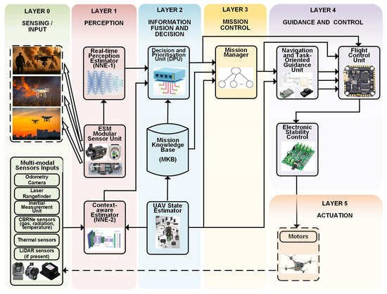
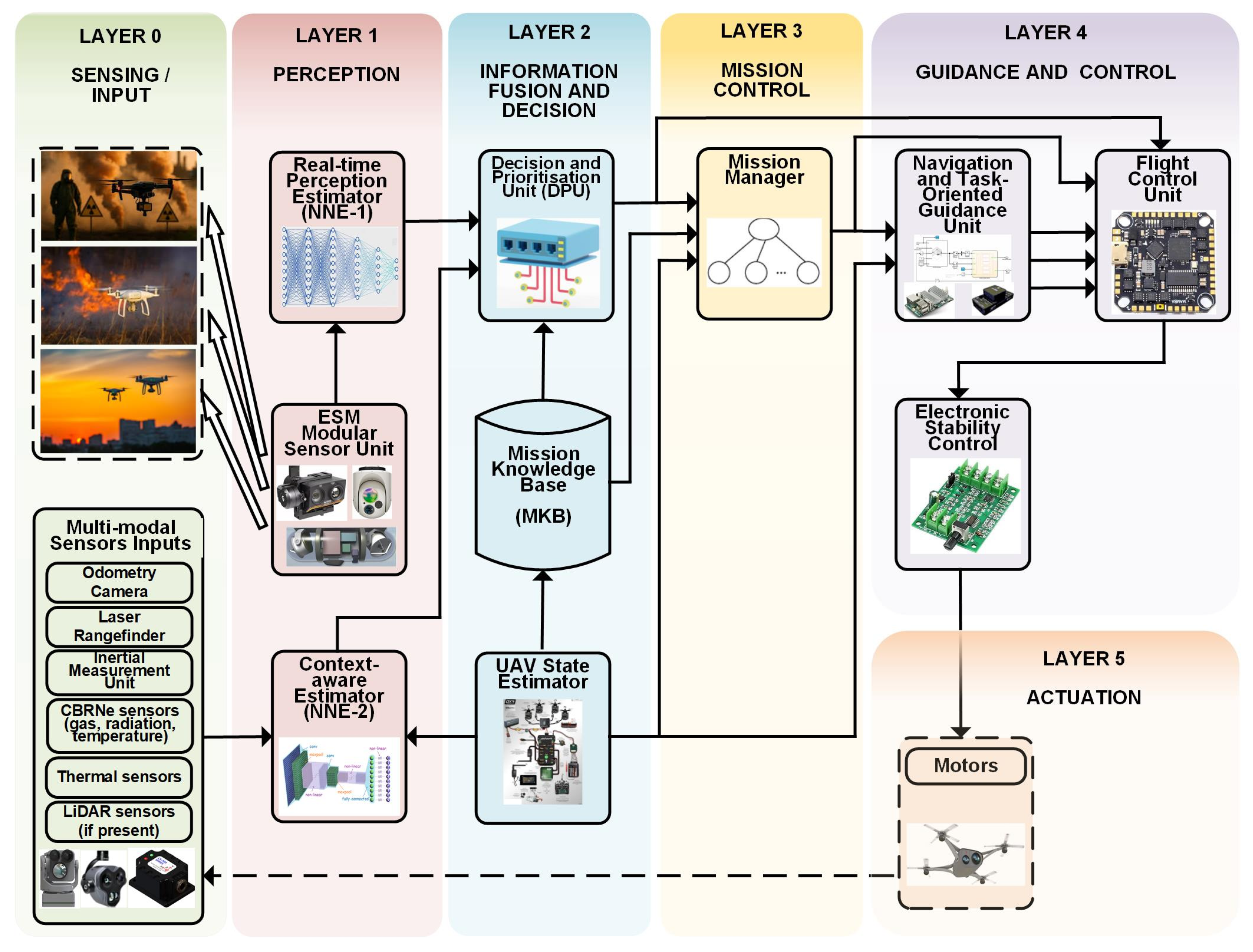
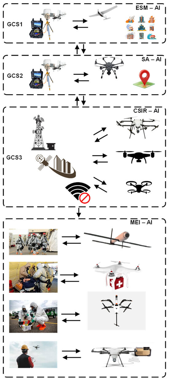
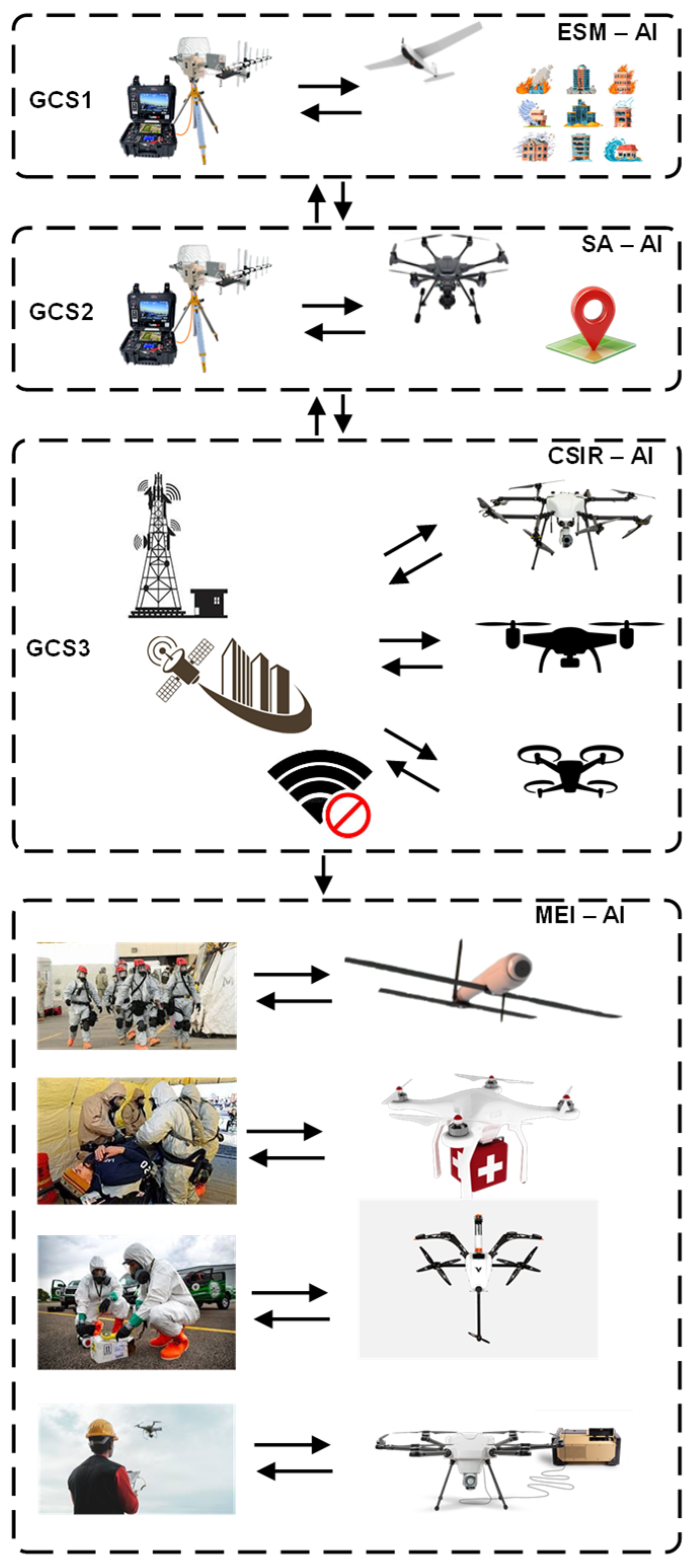
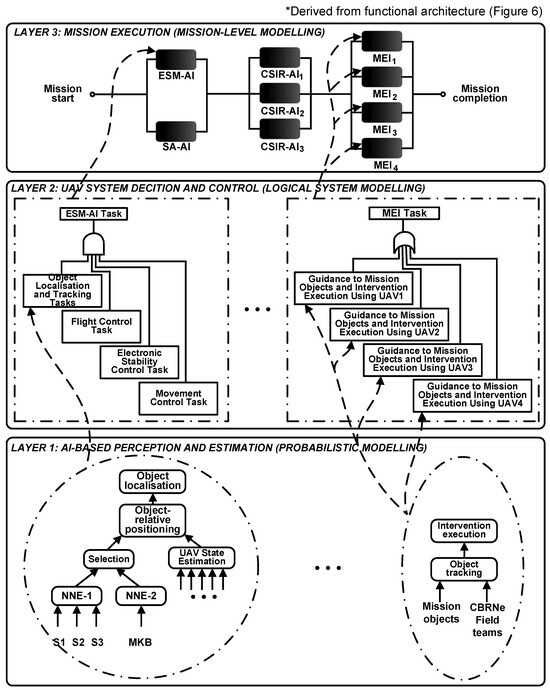
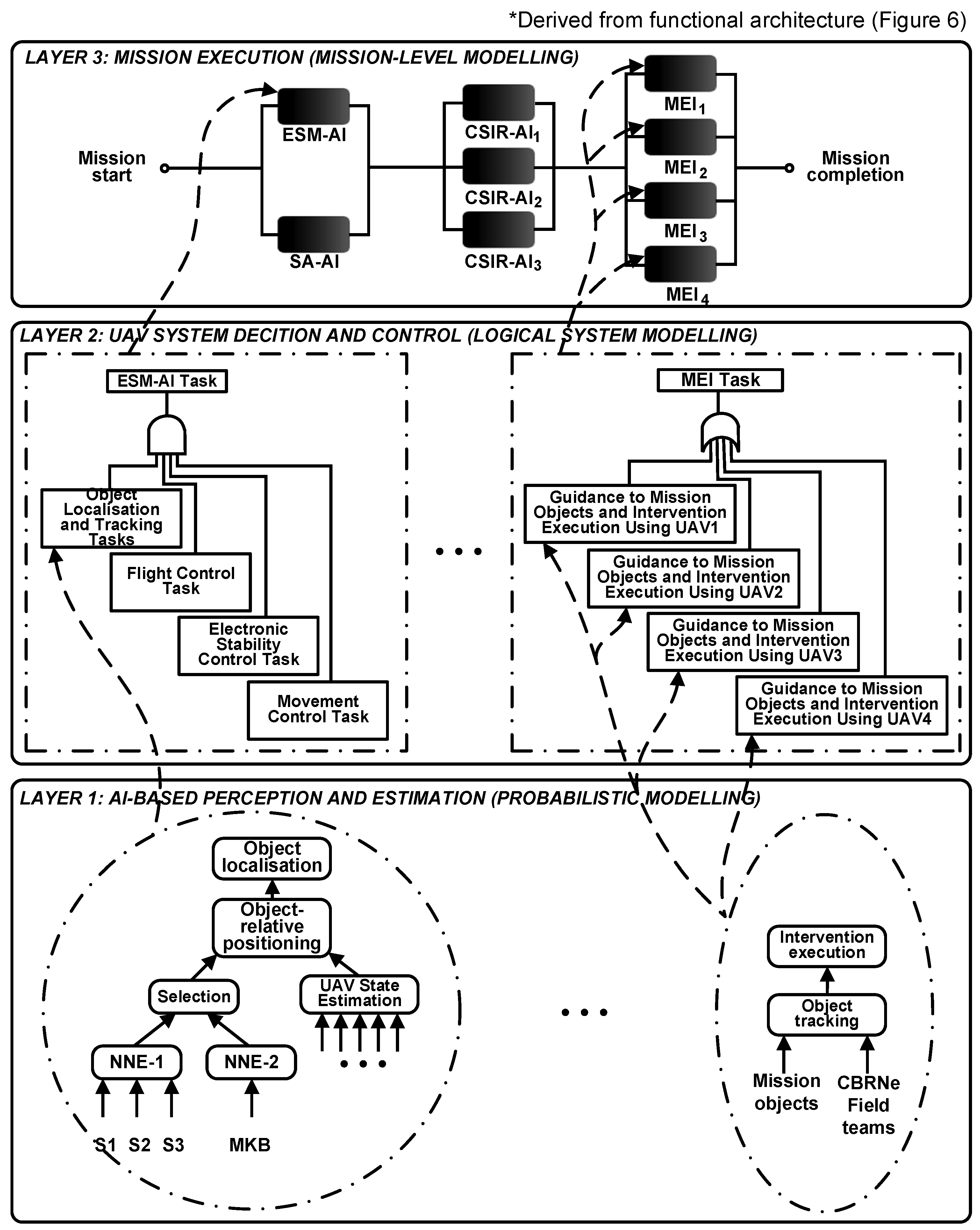
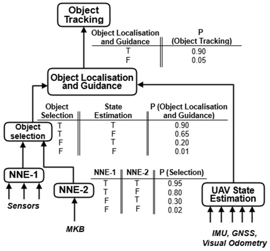
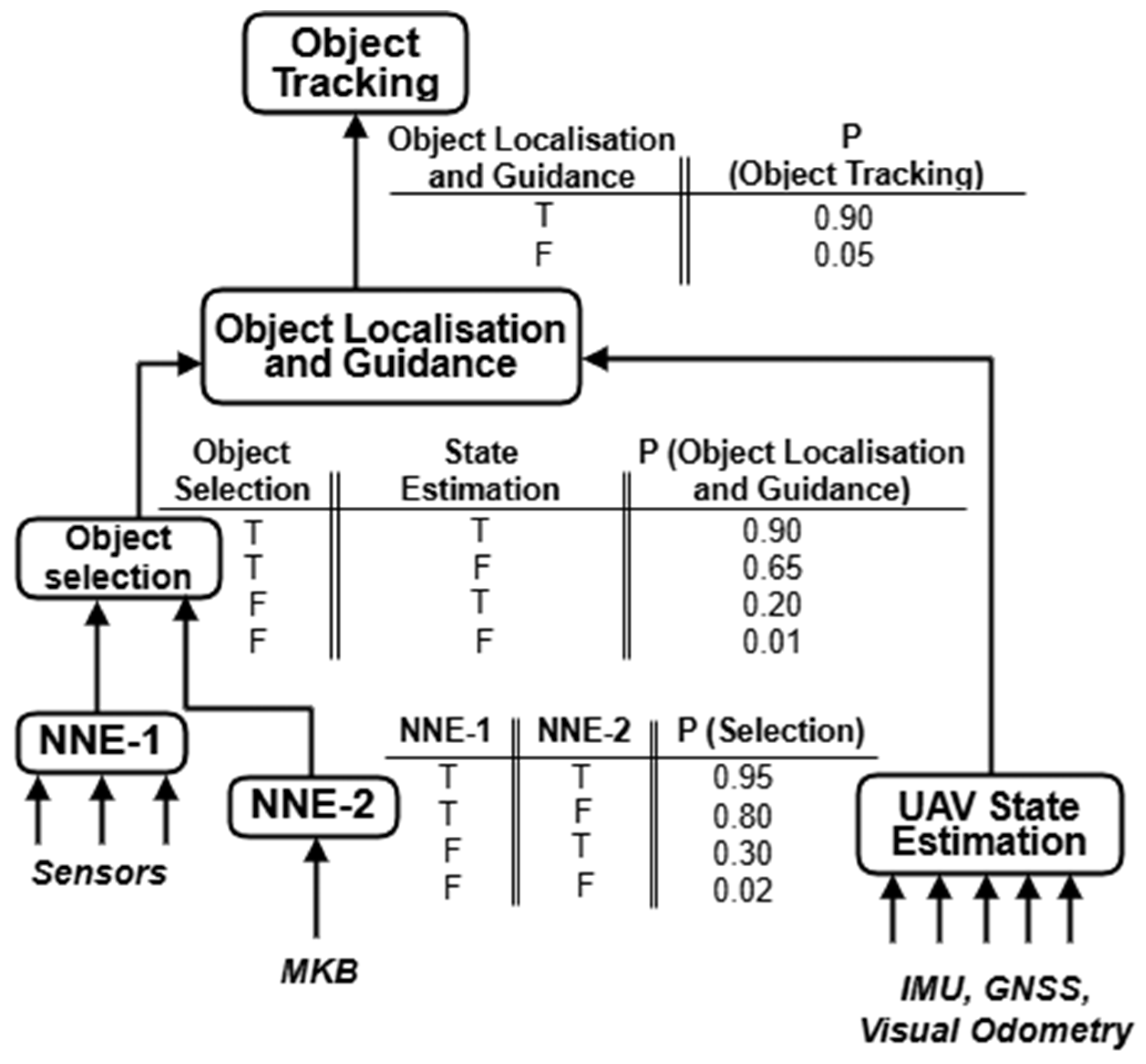
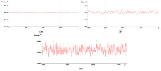
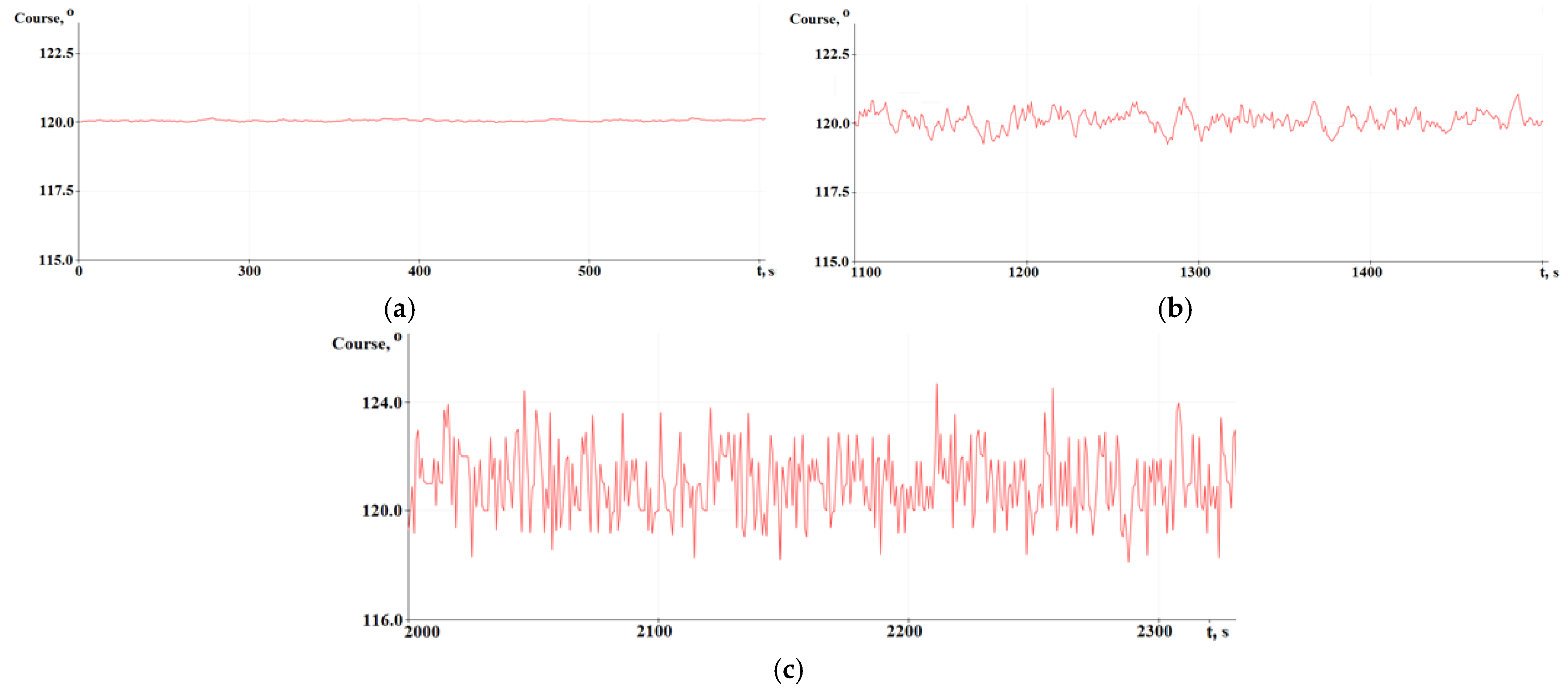
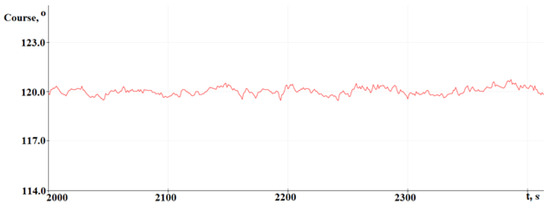
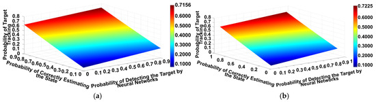
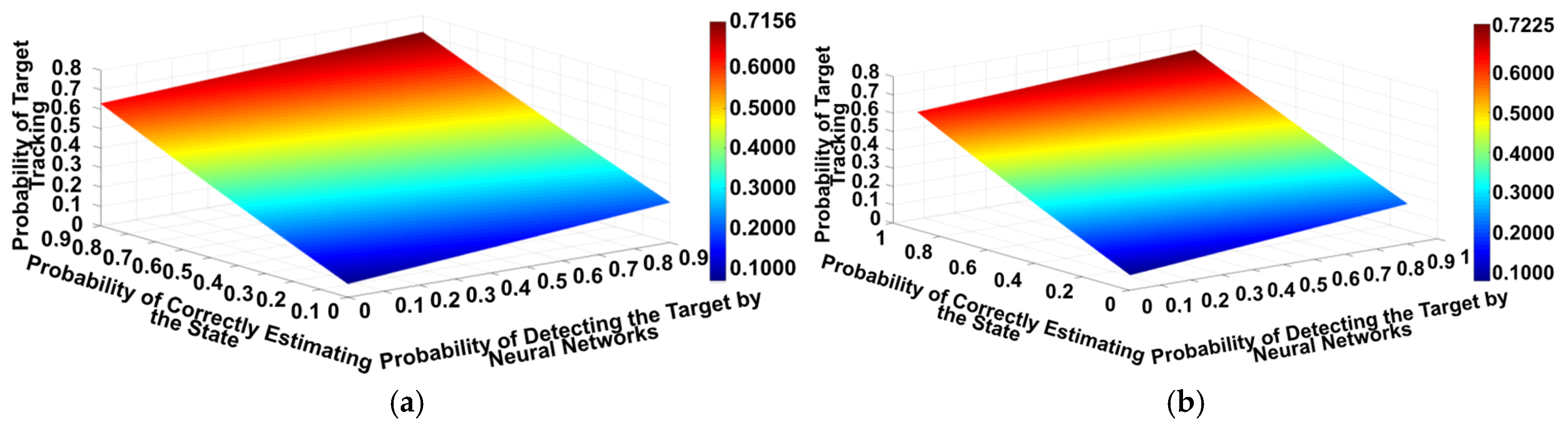
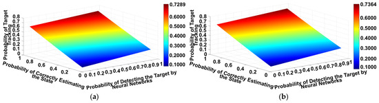
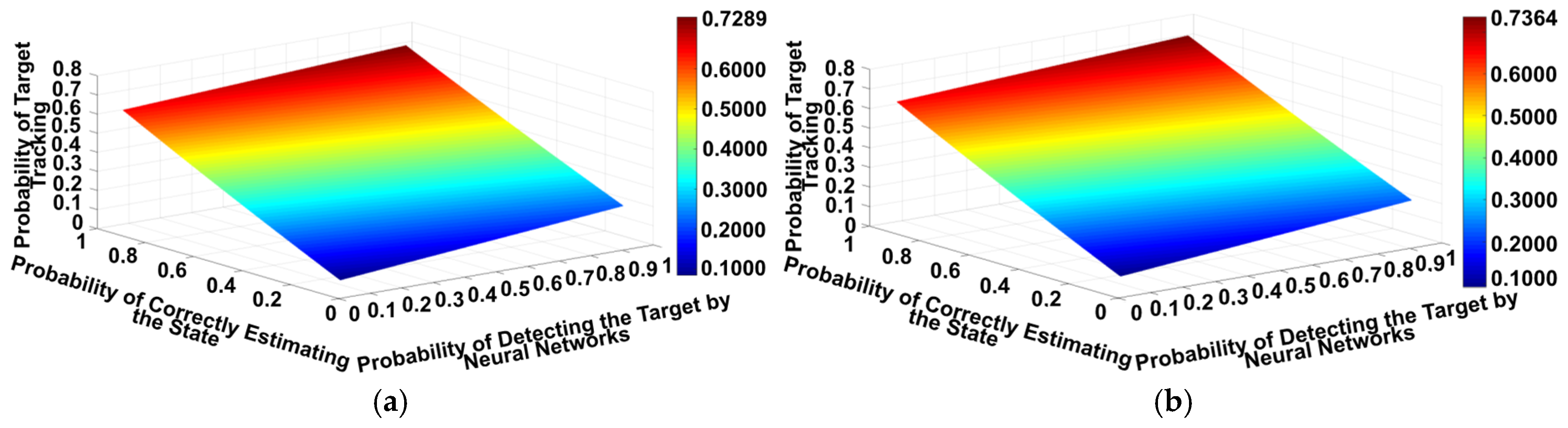
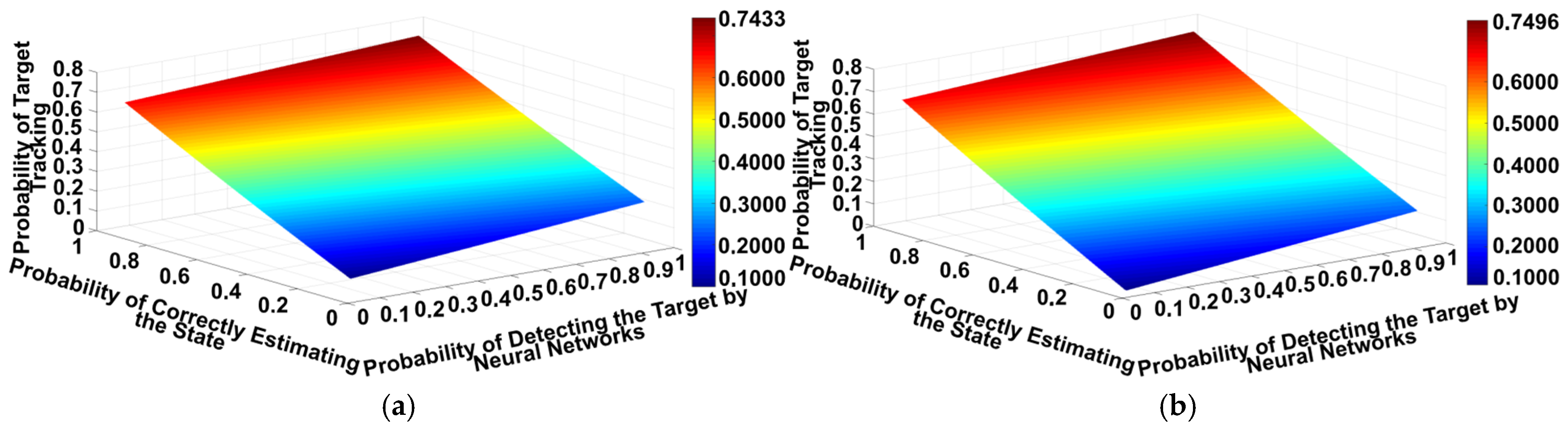
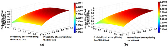
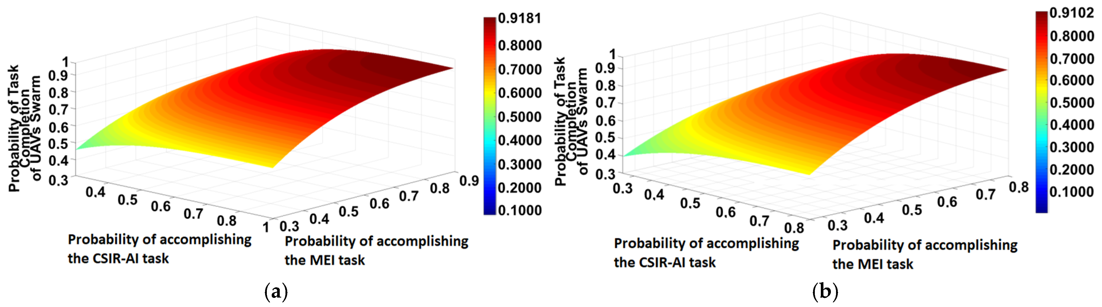
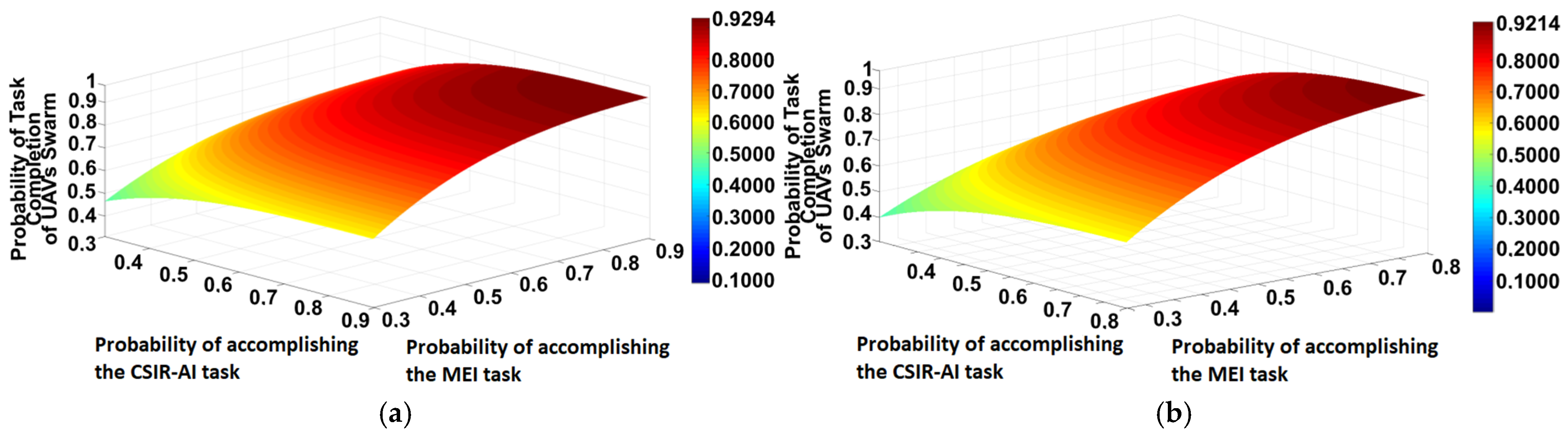
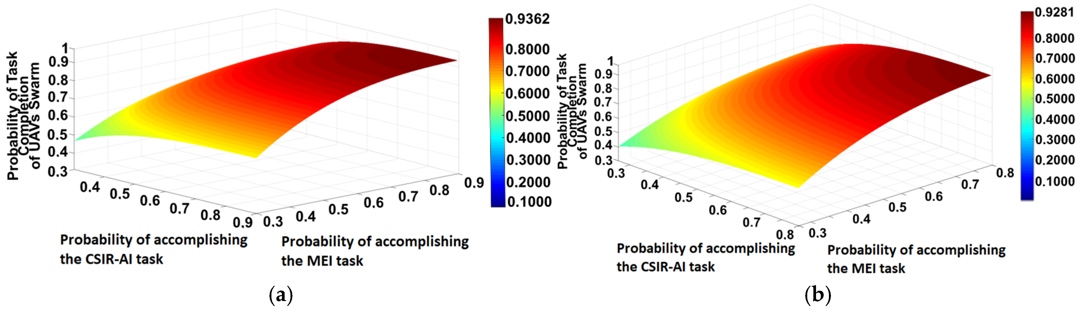

Disclaimer/Publisher’s Note: The statements, opinions and data contained in all publications are solely those of the individual author(s) and contributor(s) and not of MDPI and/or the editor(s). MDPI and/or the editor(s) disclaim responsibility for any injury to people or property resulting from any ideas, methods, instructions or products referred to in the content. |
© 2026 by the authors. Licensee MDPI, Basel, Switzerland. This article is an open access article distributed under the terms and conditions of the Creative Commons Attribution (CC BY) license.