


Highlights
What are the main findings?
- A novel ground vehicle–drone collaborative routing problem with multi-type target reconnaissance (GVD-MTR), which integrates point, line, and area targets within a unified framework, is proposed, moving beyond conventional drone-only or single-type reconnaissance paradigms.
- A knowledge-driven two-stage hybrid algorithm (KDHA) is developed to solve the problem, in which problem-specific search operators are designed by incorporating domain knowledge of target types to enhance search capability.
What are the implications of the main findings?
- The algorithm enables decision-makers to achieve comprehensive reconnaissance coverage of multi-type targets by adopting GV–drone collaborative modes rather than being limited to drone-only operations, better aligning with real-world reconnaissance scenarios.
- The algorithm also provides practical guidance for drone endurance configurations based on target type distributions, particularly as area target proportions increase, allowing practitioners to balance reconnaissance efficiency with resource utilization while preventing mission failures.
Abstract
The collaboration of ground vehicles (GVs) and drones offers a powerful approach for enhancing drone capabilities. Current research focuses on drone-only or single-type target reconnaissance, failing to adequately account for practical scenarios. This paper introduces a GV–drone collaboration routing problem with multi-type target reconnaissance (GVD-MTR), which explicitly integrates GV–drone collaboration with simultaneous reconnoitering of point, line, and area targets. To address this problem, we propose a knowledge-driven two-stage hybrid algorithm (KDHA). In the first stage, K-means clustering combined with heuristic operators is applied to generate and refine routes for the GV. In the second stage, an improved Adaptive Large Neighborhood Search (IALNS) method is implemented to produce optimized drone routes. KDHA leverages hybrid search strategies, such as a population-based initialization strategy and a multi-level acceptance strategy, to efficiently generate high-quality solutions. Regarding recognizing the impacts of different target types on the total travel distance, we incorporate the related domain knowledge to design problem-specific search operators. Extensive simulation experiments demonstrate that KDHA consistently outperforms several state-of-the-art heuristics in terms of solution quality and runtime. Sensitivity analyses further confirm the robustness of the proposed approach across a range of parameter settings and problem instances.
1. Introduction
In recent years, drones, also known as unmanned aerial vehicles (UAVs), have emerged as powerful tools in reconnaissance, offering rapid deployment, high maneuverability, and the capability to operate in complex, hazardous environments. Equipped with advanced sensors, drones can capture real-time data, including images, videos, and thermal readings, that are critical for applications such as disaster response [1], infrastructure inspection [2], and environmental monitoring [3]. However, some operations, such as disaster response, usually need to reconnoiter numerous targets in a large area, while current civil drones typically have a limited flight endurance [4]. Drones have to return to their bases frequently for recharging, which seriously prolongs the completion time of tasks and reduces operational efficiency.
To address the flight duration limitation of civil drones, the collaboration of ground vehicles (GVs) and drones appears to be a promising solution [5]. In this collaboration mode, GVs can serve as mobile bases for drones, which could carry the drones close to the targets and then launch the drones for executing tasks. This significantly extends the task range of drones, enabling them to conduct more tasks. Additionally, GVs could provide battery swapping or charging services to drones while they are moving to the next take-off point, thereby reducing the time for completing tasks. In addition to energy support, GVs can also serve as mobile wireless relays for drones [6]. Considering these advantages, industrial companies like DJI and the BYD Company have been investigating search and rescue modes based on GV–drone collaboration modes [7].
The collaboration of GVs and drones yields complex path planning challenges, which are crucial for operational efficiency. Numerous studies on the GV–drone collaboration routing problem have been carried out [5,8]. However, the major studies focused exclusively on logistics distribution scenarios, in which all service locations can be regarded as point targets [9,10]. A handful of studies on target reconnaissance consider only a single type of target, such as line targets [11] or area targets [12], while no existing studies fully account for the diversity of real-world reconnaissance target types. In practice, typical civil operations like emergency response missions demand simultaneous reconnaissance of point targets (such as damaged buildings), line targets (such as roads and bridges), and area targets (such as search zones for survivors). To bridge this gap, we investigate a GV–drone collaborative routing problem with multi-type target reconnaissance (GVD-MTR) for the first time. In this problem, a fleet of drones deployed from a GV is used to reconnoiter targets of different types, and the target types include point, line, and area targets.
The proposed GVD-MTR presents challenges beyond those encountered in the GV–drone collaboration routing problems for logistics distribution. Specifically, line targets require the drone flight direction to be considered, and area targets allow entry at any boundary point and allow infinite scanning paths. Determining the shortest scanning path for an area target, which is also connected to the drone’s endurance, further increases the complexity of the problem. The GV–drone collaboration routing problem has been proven to be NP-hard [13], making it difficult to solve in an acceptable time. To solve these kinds of problems, metaheuristic algorithms and emerging learning-based solvers (e.g., Deep Reinforcement Learning) are promising choices [14]. However, most of these traditional heuristic methods often struggle to guarantee high solution quality for complex combinatorial problems like the proposed GVD-MTR and could be computationally expensive. Meanwhile, DRL-based approaches typically impose heavy training overheads and can be sensitive to changes in constraint structure. To address these shortcomings, we develop a knowledge-driven two-stage hybrid algorithm (KDHA). It integrates domain expertise to guide the search and leverages hybrid search strategies to enhance both solution quality and efficiency.
The main contributions of this paper are as follows.
- We propose a GVD-MTR. To our knowledge, this study is the first to consider multi-type targets in the routing problem for GV–drone collaborative reconnaissance. Meanwhile, compared with the conventional method that only uses drones, the assistance of GVs can help drones achieve full-coverage reconnaissance of multi-type targets more efficiently.
- We propose a KDHA for GVD-MTR. The KDHA decomposes the GVD-MTR problem into GV routing and drone path planning subproblems and solves each subproblem using tailored techniques. The two subproblems are solved sequentially. K-means clustering combined with heuristic operators is adopted to solve the GV routing problem. Based on the GV routing results, we design an improved Adaptive Large Neighborhood Search (IALNS) algorithm for the drone path planning problem. Key enhancements of IALNS include a population-based initialization strategy for generating a high-quality initial solution and a multi-level acceptance strategy to keep the balance between intensification and diversification. Furthermore, recognizing that the different target types have different impacts on the total travel distance, we incorporate this domain knowledge into designing problem-specific search operators to further improve convergence.
- We conduct comprehensive computational experiments to verify the effectiveness of KDHA for solving GVD-MTR. KDHA is superior to the other four heuristic algorithms in terms of solution quality and time consumption, especially for instances with a larger number of targets. The effectiveness of the strategies for improving KDHA is also verified in sensitivity experiments. Additionally, managerial insights are provided based on sensitivity analyses.
2. Related Work
The drone reconnaissance routing problem has been studied for a long time. It has been analogous to VRPs with specific constraints and mathematically proven to be an NP-hard combinatorial optimization problem [15]. In 2018, Zhu et al. [16] considered the heterogeneity of targets for the first time, constructed a multi-drone mission assignment model, and developed an opposition-based genetic algorithm with double-chromosome encoding and multiple mutation operators to optimize the mission sequences of drones. Later, Chen et al. [17] developed a time-window-constrained reconnaissance mission assignment model for heterogeneous targets, employing multiple drones with distinct sensor capacities. They used an improved multi-objective symbiotic organism search algorithm to solve the problem. To solve the heterogeneous target allocation problem, Li et al. [18] simplified the complex problem with a matching matrix and used an improved particle swarm optimization algorithm and a gradient projection-based time allocation algorithm to determine the task sequence and time allocation, respectively. Gao et al. [19] divided targets into point, line, and area targets to enhance model fidelity and introduced a new heuristic algorithm named the grouped ant colony optimization algorithm. Zhang et al. [20] proposed an adaptive crowding distance method for multi-objective drone task assignment for heterogeneous targets, which ensures maximum diversity in the selection process by adaptively calculating the crowding distance based on the relative spatial distribution of feasible parent solutions in the Pareto space. Tian et al. [21] presented an extended heterogeneous-target reconnaissance task allocation model that introduced cuboid targets for 3D urban environments to improve the fidelity of the model. Xiong et al. [22] categorized the heterogeneous targets into point, line, and area targets. Considering the constraints of the UAV flight path and remaining resources, a multi-objective optimization model was constructed with fuel cost and total task time cost as the optimization objectives. Wu et al. [23] investigated the problem of maximizing mission allocation benefits for a heterogeneous drone swarm, considering critical time and multi-drone task requirements in dynamic disaster area inspection scenarios. Güven et al. [24] proposed a multi-agent reinforcement learning method based on PPO to coordinate drone teams for search and rescue operations, where targets are categorized according to different connectivity priorities.
The studies that consider GV–drone collaboration modes mainly focus on logistics distribution scenarios. Murray and Chu [25] first proposed two mathematical models for the optimized routing and scheduling of drones and delivery trucks in the new paradigm of parcel delivery in 2015. Later, Murray and Raj [26] systematically validated a truck–drone cooperative system for last-mile delivery, where drones deployed from trucks enable deliveries to remote customers, with explicit queuing strategies for drones during drone launch and recovery phases. Wu et al. [9] introduced a new truck–drone cooperative delivery model, considering the practical need for a drone to deliver multiple parcels in a single flight. Zhai et al. [27] proposed a memetic algorithm to address the truck–drone collaborative traveling salesman problem, demonstrating significantly improved delivery efficiency in complex scenarios through innovative solution representation and search operators. Luo et al. [28] proposed a mathematical model considering truck-carried heterogeneous multi-visit drones and developed a heuristic algorithm that effectively solves the drone routing problem under payload and energy constraints by integrating multiple optimization strategies. Wu et al. [29] investigated a collaborative truck–drone routing problem for contactless parcel delivery which allows multiple trucks and multiple drones to deliver parcels cooperatively in epidemic areas. Luo et al. [30] proposed an objective space decomposition-based multi-objective evolutionary algorithm with adaptive resource allocation for the multi-objective truck–drone collaborative routing problem with delivery and pick-up services. To solve the truck-and-drone coordinated routing problem for contactless delivery, Wu et al. [9] proposed an encoder–decoder framework with reinforcement learning, which requires no manually designed heuristics. Bogyrbayeva et al. [31] formulated the VRP with drones as a Markov decision process. Based on this formulation, they proposed a reinforcement learning solution with an attention encoder and a recurrent neural network decoder.
Except for the logistics distribution scenario, several studies have been investigating the application of GV–drone collaboration in reconnaissance task scenarios. For example, Tian et al. [32] addressed the endurance challenges of drones in large-scale point-target surveillance by proposing a truck–drone cooperation framework with an adaptive simulated annealing algorithm with large-scale neighborhoods for route optimization. Momeni et al. [33] developed a multi-objective mathematical programming model for cooperative forest monitoring using trucks and drones, employing the augmented epsilon-constraint method and Benders decomposition algorithm to evaluate the model’s performance in large-scale problems. Xia et al. [12] proposed a novel two-layer path planning method for cooperative GV–drone systems, where the GV acts as a mobile deployment platform to enable the drone to perform multiple area coverage tasks, with the joint optimization problem formulated as a 0–1 integer programming model and solved via an Adaptive Large Neighborhood Search (ALNS) algorithm. Xu et al. [11] innovatively proposed to coordinate GVs and drones to monitor urban road networks more efficiently and developed a hybrid optimization algorithm combining randomized variable neighborhood descent search with the simulated annealing algorithm to solve the model. To tackle the coordinated arc routing scheduling in Truck–Drone Collaborative Traffic Patrolling, Cheng et al. [34] formulated the Truck–Drone Arc Routing Problem and proposed a divide-and-conquer-based framework, achieving significant efficiency improvements through collaborative scheduling. Liu et al. [35] proposed a cooperative GV–drone system for high-voltage powerline inspection and solved the involved path planning problem using a two-layer optimization algorithm. Jayaweera et al. [36] proposed the enhanced dynamic artificial potential field technique, which formulates the path planning for GV–drone collaboration under non-gimbal sensors as a dual-objective follow-and-cover problem, enabling real-time reconnaissance of the environment ahead of the mobile ground vehicle and dynamic obstacle detection. Savkin et al. [37] designed a model predictive control-based multi-UAV path planning algorithm for a trajectory planning problem, in which a fleet of drones follows several ground vehicles on uneven terrain for video surveillance.
While significant progress has been made in the research on GV–drone collaboration routing problems, existing studies focus primarily on single-type targets. To the best of our knowledge, no work has addressed the challenges posed by multi-type reconnaissance targets in GV–drone collaboration routing problems. However, in real-world operations, tasks frequently involve a mix of point, line, and area targets. To bridge this gap, we propose a new problem named GVD-MTR. To solve such complex routing problems, exact solvers such as Gurobi may not scale well for large instances, while heuristic-based and RL-based methods have recently emerged as state-of-the-art trends. However, the proposed GVD-MTR involves multiple tightly coupled constraints and instance-specific details. For RL-based solvers, their training data requirements, reward design complexity, and sensitivity to changing constraint structures make them less suitable for GVD-MTR. Accordingly, the heuristic-based solver could be a transparent and deployment-friendly alternative. Therefore, we propose a novel knowledge-driven two-stage hybrid algorithm.
3. Problem Formulation and Models
3.1. Problem Description
In the proposed GVD-MTR, a GV carries a fleet of drones to perform reconnaissance of heterogeneous targets. The GV and drones depart from a common base and return to the base after all targets have been reconnoitered. Different from most previous studies in which the GV must launch the drones from task points [5], we allow drones to be deployed from a set of virtual launch points that need not coincide with point targets. This relaxation is justified for two reasons. First, line and area targets do not naturally yield discrete launch locations, so it is difficult and unnecessary to define a launch point at line targets and area targets. Defining a virtual point that is close to multiple targets for launching drones could improve operational efficiency and reduce costs [38]. It should be noted that the virtual points are geometric constructs determined by the spatial distribution of task locations and are not intended to represent exact physical deployment coordinates. In practical scenarios, GVs are subject to terrain and accessibility constraints and can only stop at traversable and operationally feasible locations, such as road network nodes or open areas suitable for drone deployment. To bridge this gap, each virtual launch point could be associated with a nearby feasible stopping location selected from a predefined set of accessible nodes. Drone launch and recovery operations can be performed at the accessible node rather than at the virtual point itself. As the primary objective of this study is to optimize the vehicle visiting sequence and GV–drone coordination decisions, we treat the virtual launch points as abstract representatives of accessible locations of the GV [39,40], while detailed terrain-aware feasibility can be incorporated as a post-processing step in further applications. During the reconnaissance process, upon the GV reaching a virtual point, each drone sequentially launches from the GV and visits nearby targets along an optimized coverage route that ensures full reconnaissance of each target exactly once. When a drone completes all tasks within its endurance range, it will be retrieved and recharged by the GV waiting at the same virtual point. Each drone route encompasses inter-target routes and inner-target routes.
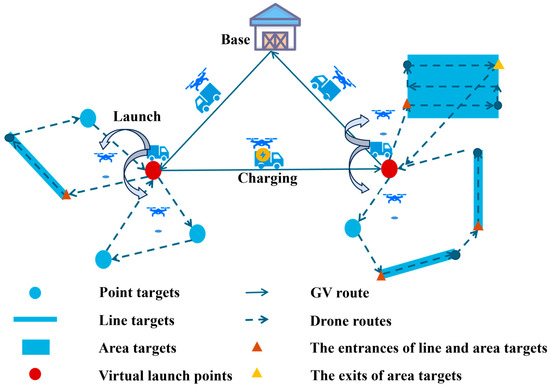
An illustration of GVD-MTR is shown in Figure 1, where targets are categorized into point targets, line targets, and area targets. The blue dots denote point targets, which the drones leave immediately after a single visit. The blue lines represent line targets, requiring the drones to traverse from one endpoint (marked by a brown triangle) to the other to complete the coverage. The blue rectangles indicate area targets, where the drones must enter through the entrance marked by a brown triangle, perform a full area scan, and then exit via the exit denoted by a yellow triangle. Red dots represent virtual points, solid lines represent the GV route, and dashed lines indicate the drone routes.
Figure 1.
Illustration of GVD-MTR.
To facilitate the modeling, some reasonable assumptions are made as follows:
- Drones are homogeneous and equipped with identical sensors.
- Drones fly at a constant speed, and the energy consumption during takeoff and landing is negligible.
- The GV travels at a constant speed and has sufficient endurance to support the operational scale.
- Mid-air collisions among drones are negligible when the GV launches or retrieves multiple drones simultaneously.
3.2. Reconnaissance Strategies for Multi-Type Targets
Considering the characteristics of point, line, and area targets, we detail the specific reconnaissance strategies for these targets for efficient operation before constructing the mathematical model.
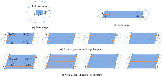
(1) Point Target. As shown in Figure 2a, when a drone hovers over the center point of a target and the entire target can be covered by the field of view (FOV) of the drone sensor, we define it as a point target. For a point target, we assume that a drone can finish the reconnaissance once it reaches the top of the target.
Figure 2.
Reconnaissance strategies for different types of targets.
(2) Line Target. As shown in Figure 2b, if the length of the target exceeds the FOV while the width is within the FOV, the target is defined as a line target. This requires the drone to fly along the longer side from the center point of one short side to the center point of the opposite short side. Therefore, the center points of the short sides are designated as the two feature points of the line target, and the length of the longer side (i.e., the distance between these two feature points) represents the reconnaissance travel distance. In addition, since the line target allows two possible entry directions, the drone should explicitly account for the selected entry and exit points, which also determine the reconnaissance direction of the line target.
(3) Area Target. When both the length and width of a target are not within the FOV of the drone sensor, we define it as an area target, as shown in Figure 2c. To facilitate the calculation of the reconnaissance route, the area target could be approximated as a rectangle. To minimize energy consumption caused by frequent turns, a back-and-forth trajectory along the longer edge of the rectangular area is adopted for area target reconnaissance, where s denotes the drone entry point and e represents the exit point, with the length of the dashed line indicating the coverage travel distance for the area target. Based on the variation in short-edge lengths, we can derive two types of entry–exit point pairs, i.e., same-side pairs, as shown in Figure 2c, and diagonal pairs, as shown in Figure 2d. Given the four vertices of an area target, four distinct coverage schemes (i.e., four entry–exit point pairs) can be derived. While these schemes share identical coverage paths, they yield varying inter-target travel distances between consecutive targets, thereby affecting the total travel distance of vehicles. Therefore, for area targets, it is necessary to determine a reasonable drone entry point, which could also define the corresponding exit point.
More formally, a target, , could be represented by a tuple , where , representing point, line, and area targets (i.e., 0 for point targets, 1 for line targets, and 2 for area targets, respectively), and represents the set of feature points of the target. For a point target, the feature point is represented by its center point . For a line target, the two center points (i.e., and ) of the two short sides are taken as the feature points. For an area target, four feature points are defined as the points located on the short edges at a distance equal to the FOV radius from each vertex (i.e., ).
Therefore, could be written as
Then, the coverage travel distance, , of an area target can be calculated by
where is the FOV radius of the drone sensor, is the length of the longer side of the area target, and is the length of the shorter side of the area target. denotes the ceiling function, returning the smallest integer greater than or equal to .
3.3. Mathematical Model
All notations used in the model are described in Table 1. Note that, to facilitate the modeling, we represent all types of targets by feature points. Meanwhile, a single drone may be assigned to target reconnaissance across multiple distinct subareas, such that multiple drone routes in the final feasible solution are executed by the same drone. To facilitate model formulation, we define a set of drone trips, to represent all available drone trips existing in any particular solution (i.e., the solution set of all drone routes obtained by solving the drone path planning subproblem), as in [41]. Each drone that belongs to the drone trip may visit multiple targets in a flight within its flight endurance.
Table 1.
Notation description.
The mathematical formulations of GVD-MTR are presented as follows:
Equation (3) aims to minimize the total travel distance of the vehicles, which includes three components: the travel distance of the GV route, the travel distance of the drones between feature points (i.e., the sum of the inter-target distance and the coverage distance over line targets), and the coverage distance of the drones over area targets. The first component and the latter two components are optimized in the GV routing stage and the drone routing stage, respectively. Therefore, there is no direct trade-off between them, and we did not introduce a weighting coefficient for these components.
Constraint (4) limits the flight distance of each drone to its maximum range. Constraint (5) requires the GV to visit each virtual point exactly once. Constraint (6) enforces that each feature point is visited by a drone exactly once. Constraint (7) mandates that each target be visited by a drone exactly once. Constraints (8) and (9) specify that the GV must both start and end its route at the base. Constraints (10) and (11) require each drone route to begin and end at virtual points. Constraint (12) maintains flow balance for each drone at every virtual point. Constraint (13) prohibits drones from flying directly between the entry and exit points of an area target, preventing a direct connection. Finally, Constraint (14) enforces that each drone route includes the connecting segment between the two feature points of a line target. Constraint (15) eliminates subtours in GV routing by preventing the formation of disconnected cycles among subsets of virtual points. Constraint (16) eliminates subtours in each drone trip by prohibiting the existence of isolated cycles within the set of feature points assigned to a drone route.
4. Solution Approach
In this section, we detail the proposed KDHA and elaborate on its key components.
4.1. Solution Method Framework
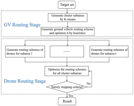
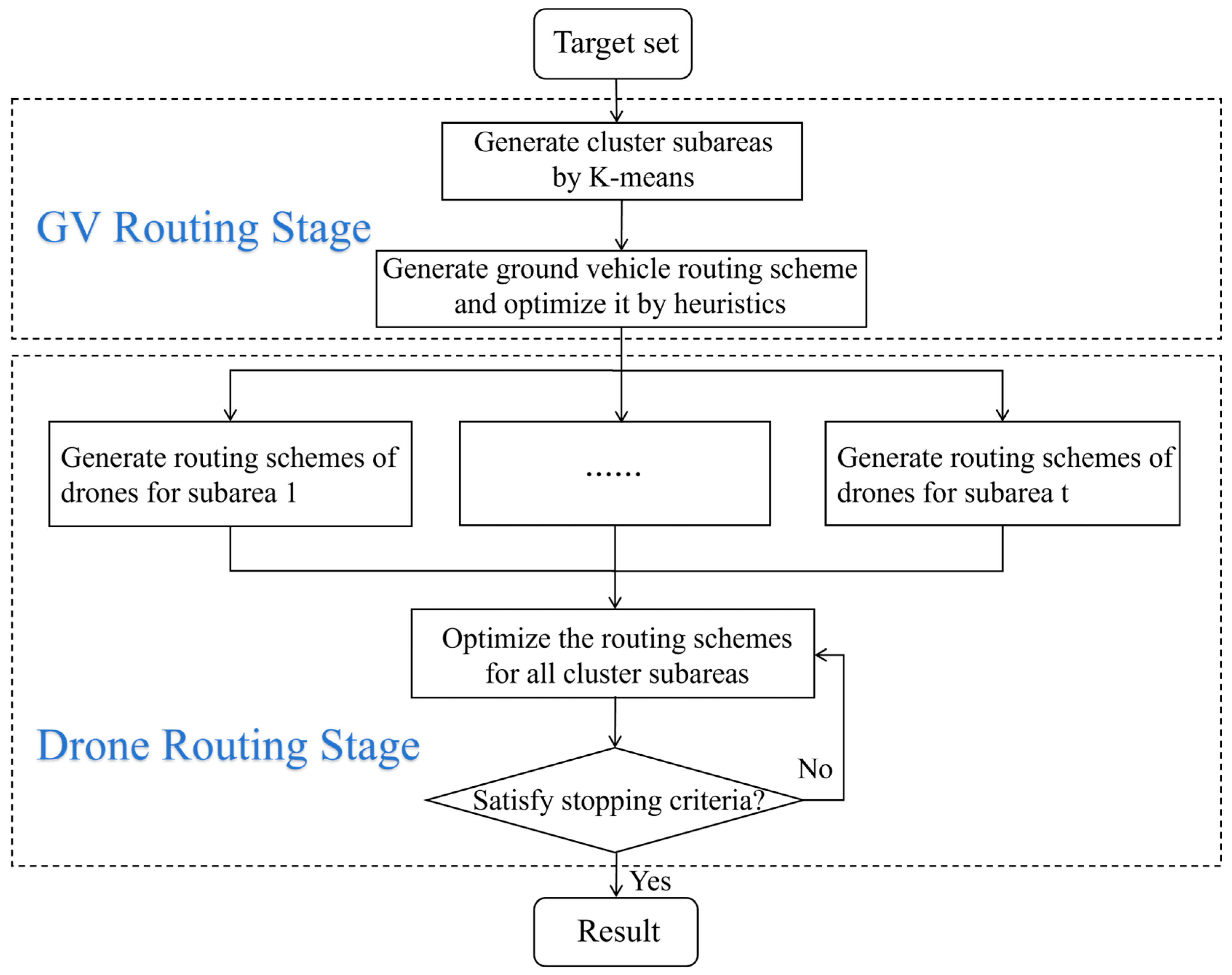
The flowchart of the proposed KDHA is depicted in Figure 3. The KDHA consists of two stages: the GV routing stage and the drone routing stage.
Figure 3.
Flowchart of KDHA.
In the GV routing stage, the algorithm begins by identifying virtual points for launching drones and then calculates an optimized GV route that visits these virtual points and the base. Virtual points are obtained via K-means clustering, using two key parameters, i.e., the distance from targets to the base and the drones’ maximum flight range, where the centroid of each line and area target is taken as its representative point during clustering to reduce spatial complexity. The resulting cluster centers serve as virtual points. Since multiple target types are considered in GVD-MTR and we aim to find virtual points that are relatively close to all targets, K-means is an ideal choice for this task. By using centroids to represent line and area targets, it can efficiently compute geographically proximate compromise points for targets, which serve as virtual points where the GV deploys drones. Next, we generate an initial GV route by randomly permuting the order of virtual points. This route is then refined through heuristic operators such as 2-opt and 3-opt, which have been demonstrated to have good performance in addressing vehicle routing problems [42]. The detailed workflow for this stage is given in Algorithm 1 in Section 4.2.
In the drone routing stage, we aim to obtain cooperative multi-drone routes within each subarea defined by the virtual points. We propose an IALNS for this stage, as described in Algorithm 2. Key enhancements include a population-based initialization strategy, problem-specific destroy and repair operators, and a multi-level acceptance strategy. Further details of the IALNS components are provided in Section 4.3.
In KDHA, the two stages are executed sequentially. The drone path planning takes the clustering results and the GV route as inputs. Specifically, the cluster process assigns the targets to each subarea that consists of all targets in a cluster. The visit sequence of cluster centers (i.e., virtual points) is determined by GV route planning. Then, the drone path planning will be performed to determine the visit sequence of all targets in each cluster. Each drone route starts and terminates at the virtual points. After the drone path planning, the GV and drone routes are integrated into a complete solution for GVD-MTR.
4.2. Heuristics for GV Routing Stage
The GV routing problem can be regarded as a traveling salesman problem. To address this problem, we design a heuristic method based on 2-opt [43] and 3-opt [44] operators, as shown in Algorithm 1. In the 2-opt operator, two points are selected at random, and the subtour between them is reversed. The change caused by the operator is accepted only if it reduces the total route length, otherwise the original sequence is retained. Similarly, the 3-opt operator removes three edges at non-adjacent points, evaluates all possible reconnection patterns, and adopts the one with the smallest cost. Both operators are triggered at random during the search to help avoid premature convergence to a local minimum, as described in lines 4–14 of Algorithm 1.
| Algorithm 1 Heuristics for GV routing stage |
| Input: the information of all targets and the base. Output: the targets and virtual points of subareas, optimized GV routing scheme.
|
4.3. IALNS for Drone Routing Stage
We develop IALNS to generate drone routes, with the virtual points serving as both the starting and ending points of drone routes, as described in Algorithm 2.
| Algorithm 2 IALNS |
| Input: result of K-means clustering, target information, parameters of IALNS. Output: drone routing schemes.
|
At the outset, we adopt a population-based initialization strategy to generate an initial solution set, , and then the best solution selected from is regarded as the initial solution and the global best solution (lines 1–3). The solution is then optimized using an adaptive local search process to find the optimized solution (lines 4–30). In each iteration, a new solution is generated by destroying and repairing operators (lines 4–7), followed by a multi-level acceptance strategy to decide whether to accept the new solution or perform an additional search (lines 8–28). To prevent the over-favoring of certain operators, we update their selection weights at regular intervals based on recent performance (lines 29). Finally, the algorithm outputs the optimized drone routing scheme.
(1) Population-Based Initialization Strategy. The quality of the initial solution has a major impact on convergence speed, making its generation method critical. Typical approaches fall into two categories: constructive and iterative. Constructive methods can produce solutions quickly but may sacrifice quality, whereas iterative methods improve solution quality through repeated refinements at the cost of increased computation time. To strike an effective balance, we employ a population-based initialization strategy. We use a problem-specific constructive algorithm to generate each candidate solution of the population efficiently, without requiring many iterations, yet still achieving acceptable quality. In addition, different from the conventional constructive methods that yield the same solution each time, our approach integrates random factors. Moreover, although random initialization may increase the optimization time, the computational overhead remains manageable due to the reduced number of targets in each subarea after clustering while simultaneously enabling the generation of a more diverse set of initial solutions. Then, we select the best solution from this population to serve as the initial solution. This strategy maintains high solution quality while mitigating the drawbacks of limited iterative refinement.
When generating an initial solution, we sequentially construct a sub-initial solution for each cluster subarea and then combine these sub-initial solutions. Specifically, in each cluster subarea, we first randomly generate an ordered sequence containing all targets of the subarea. Since the targets are represented by feature points, we connect the feature points of the targets to construct the drone routes. Similar to the nearest neighbor algorithm, we select feature points one by one according to their distances. For line and area targets, the entry point is the feature point closest to the assigned feature point in the current step. The exit point of the area targets is selected from the other three feature points according to the shortest area coverage path planning result starting from the entry point. Upon a complete route connecting all feature points being constructed, the route is partitioned into several drone routes starting from and returning to the same virtual point according to the operation constraints, e.g., the endurance limitation of the drones.
An example of an initial solution within a subarea is displayed in Figure 4, in which three drone routes are constructed within the subarea.
Figure 4.
An example of an initial solution within a subarea.
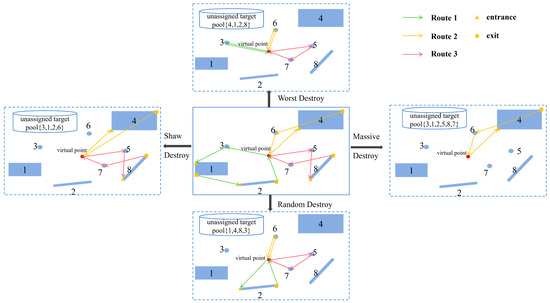
(2) Destroy Operators. Destroy and repair operators are key components of the IALNS. In each iteration, several targets will be removed from the current solution using a destroy operator, and then the removed targets will be inserted into the solution based on a repair operator. To obtain high-quality solutions, we design four destroy operators and four repair operators based on problem knowledge. The destroy operators include massive destroy, random destroy, shaw destroy, and worst destroy operators, as described in the following.
- Massive Destroy: Randomly select two drone routes and delete all the targets in them.
- Random Destroy: Traverse all drone routes and randomly remove one target each time until the specified number of targets have been removed.
- Shaw Destroy: Remove the targets with a high degree of correlation with the previously removed target. Specifically, first remove a randomly selected target. Then, the remaining targets in the current solution are sorted according to their correlation degree with respect to the removed target. The targets with a high correlation degree are removed from the solution one by one until a specified number is reached. In this study, the correlation degree is represented by the distance between targets. The center points of the line and area targets are used for calculating the distance.
- Worst Destroy: Remove the targets that have the greatest impact on total travel distance. Specifically, the targets in the current solution are sorted according to their impacts on the total travel distance, and the targets with a high impact are removed from the solution one by one until a specified number of targets has been removed. Impact means a reduction in the total travel distance after the removal of the target.
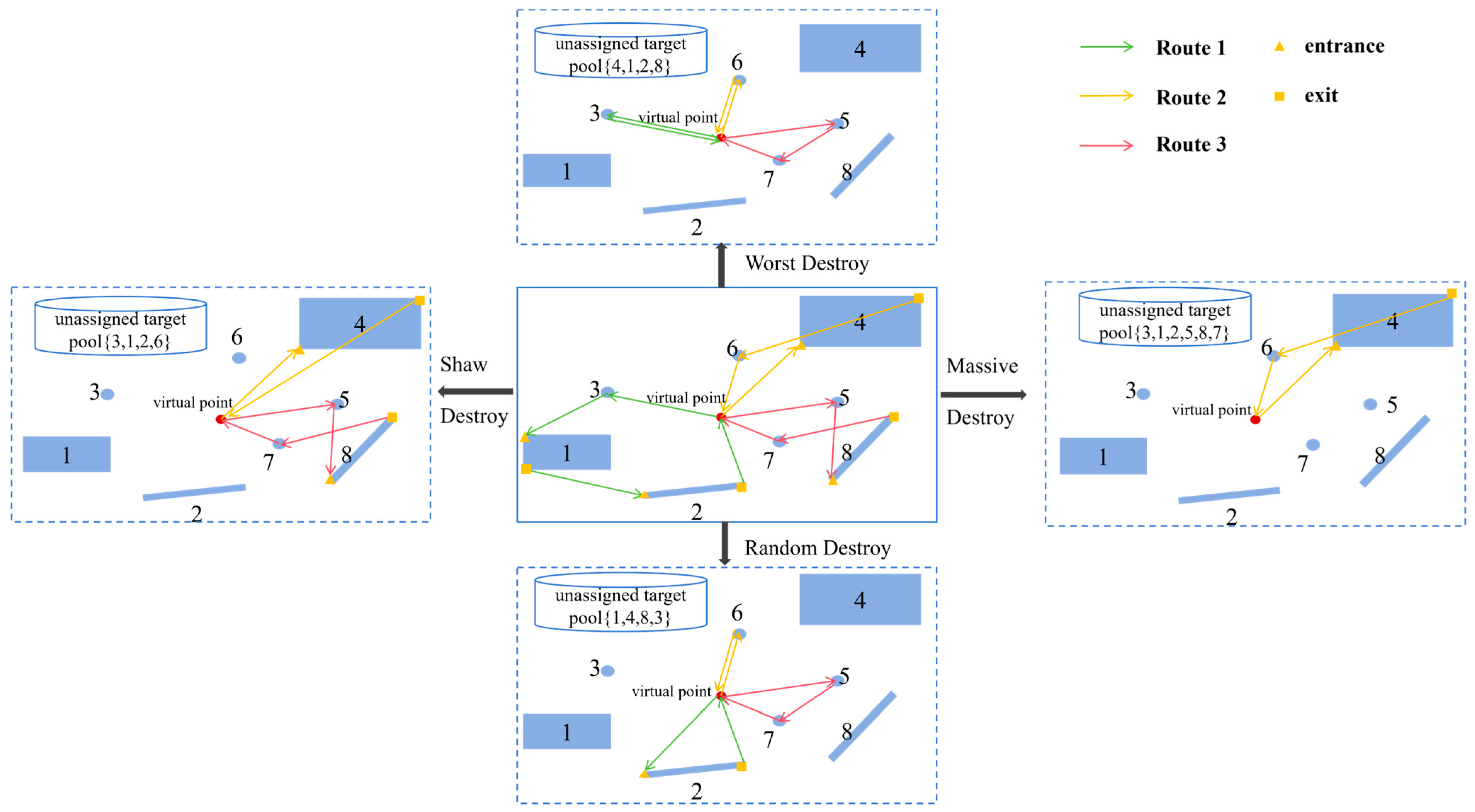
Assuming that the removal of four targets is specified for the latter three operators, an example of the four destroy operators is presented in Figure 5.
Figure 5.
An example of destroy operators disrupting drone routes within a subarea.
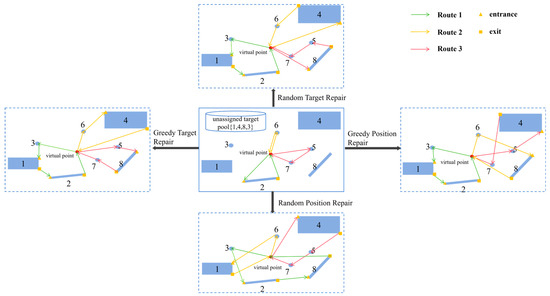
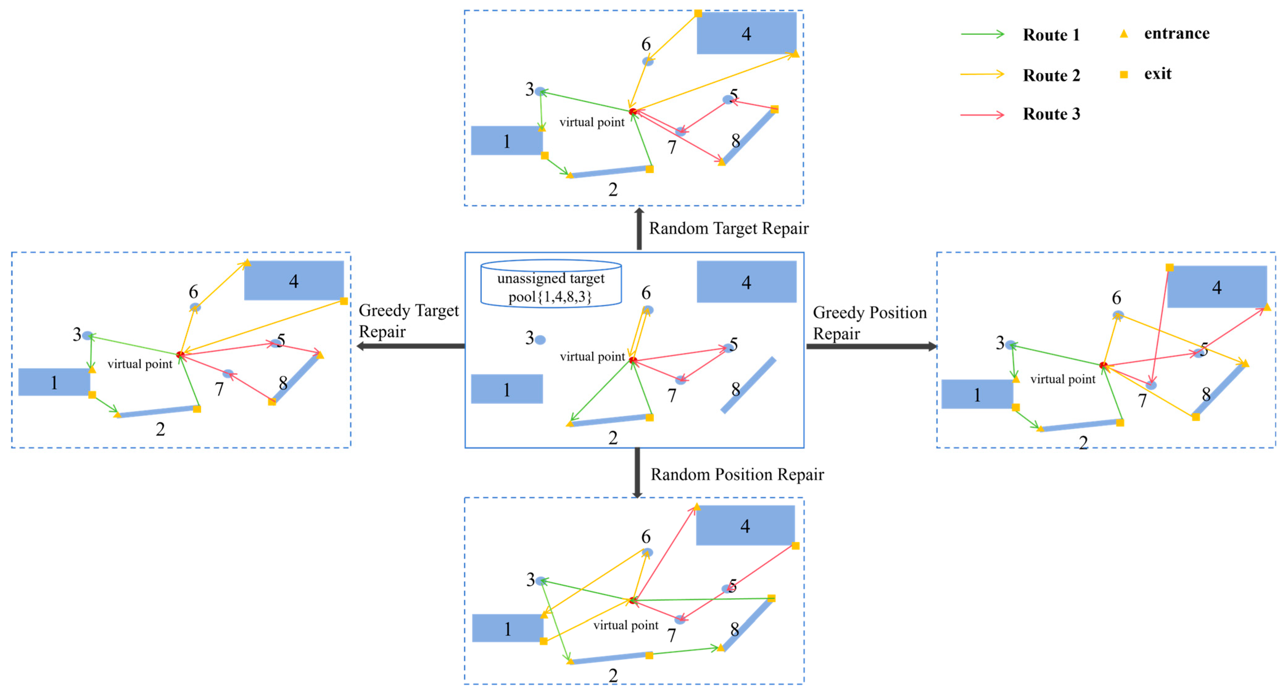
(3) Repair Operators. The repair operators include greedy position repair, greedy target repair, random position repair, and random target repair operators, as described in the following.
- Greedy Position Repair: Insert targets into the position where the increase in the total travel distance is minimal.
- Greedy Target Repair: Different from the greedy position repair operator, this operator will consider the impacts of target type on the increase in the total travel distance. Specifically, area targets require the drone to scan the entire region and therefore entail a greater distance than line and point targets. Line targets require the drone to traverse the entire line and thus incur greater distances than point targets. Considering this knowledge, the operator will assign area targets first, then line targets, and finally point targets. Meanwhile, to determine the assignment order within the area and line categories, targets are sorted in descending order by the travel distance needed to cover them. For point targets, they are sorted in descending order by their distance from the subarea virtual point. Then, each target is inserted into the position that yields the smallest increase in total travel distance sequentially. The underlying purpose is to offer more expensive targets more insertion options so that better solutions can be found.
- Random Position Repair: Insert each target into a randomly selected feasible position in a randomly selected route that satisfies the constraints. This operator is designed to enhance the diversification capability of search.
- Random Target Repair: Similar to the greedy target repair operator, the impacts of target type on the total travel distance are also considered by this operator. This operator sorts targets in the same manner as the greedy target repair operator. Then, each target is inserted into the randomly selected feasible position in a randomly selected route that satisfies the constraints. Compared with the random position repair operator, this operator could reduce computational overhead while preserving a degree of search diversification.
Examples of the four repair operators are shown in Figure 6. Note that when inserting an area or line target into a route, we connect its feature points to other targets using the same procedure employed during the initial solution generation, thereby ensuring the minimum increase in total distance.
Figure 6.
Drone routes restored by the four repair operators within a subarea.
(4) Adaptive Mechanism. In IALNS, the adaptive mechanism periodically updates the weight for the destroy–repair operator pairs. The selection of operator pairs follows a roulette wheel mechanism [45], where the probability of selection is proportional to the current weight of each pair. Since the effectiveness of operator pairs varies across different clustered subareas, weight updates are determined by global solution evaluations rather than local performance. This periodic weight adjustment effectively prevents selection bias that may arise from overemphasizing the superior performance of specific operator pairs in individual subareas. The formula for updating weights in IALNS is as follows:
where is the updated weight, is the current weight, is the current score of the operator pair, is the number of times the operator pair has been used, and is the reaction factor, which controls the update speed of weights. The higher the value of , the faster the update reaction. is the normalization factor, used to adjust the magnitude of rewards and punishments, ensuring that they are within a reasonable range, and it is a global configuration parameter.
(5) Multi-Level Acceptance Strategy. We design a multi-level acceptance strategy for IALNS to strike a balance between intensification and diversification of the search. This criterion determines whether to accept new solutions and assigns distinct scores to destroy–repair operator pairs based on three different levels, where higher scores indicate better performance of the destroy–repair operator pairs. Meanwhile, the infeasible solutions are tackled using an infeasible solution resolution strategy and re-evaluated to fully utilize the search efforts. The details of the multi-level acceptance strategy are described as follows.
- If a new solution obtained is valid and globally optimal: Update the best solution and the current solution and increase the operator-pair score by .
- If a new solution is valid but not globally optimal: If the new solution is better than the current solution, accept it as the current solution and increase the operator-pair score by ; if the new solution is worse than the current solution, increase the operator-pair score by . Meanwhile, if the new solution lies within the tolerance range of the best solution, , the solution can still be accepted.
- If a new solution is invalid: Apply an infeasible solution resolution strategy to obtain a feasible solution and increase the operator-pair score by . The infeasible solution resolution strategy aims to tackle the situation in which some targets cannot be assigned in the repair stage. Specifically, once an infeasible solution is generated, it will perform a 2-opt local search based on the current infeasible solution and then try to insert the unassigned targets based on the greedy repair operator. If a feasible solution is obtained, the first two judgment levels of this multi-level acceptance strategy will be triggered again to determine whether to accept the new solution. This step is designed to fully utilize the search efforts by searching the region near the infeasible solution, thereby further improving the intensification capability of the algorithm.
5. Experiments
This section evaluates the performance of the proposed KDHA based on extensive comparison experiments. Sensitive experiments were conducted on both the key algorithm parameters and problem-specific parameters to verify the robustness of KDHA. All algorithms were coded in Python 3.10.11 and run on a PC with a Core i5-13500H 2.60 GHz CPU, 32 GB of memory, and the Windows 10 operating system.
5.1. Experimental Setup
(1) Benchmark Instances. Given the absence of existing benchmark instances for GVD-MTR, we adapted the CVRP problem’s A-series dataset from the Solomon benchmark [46] to create 30 multi-type target reconnaissance instances, A1–A30. As detailed in Table 2, these instances feature varying spatial distributions and quantities of heterogeneous targets (point/line/area targets), with all randomly generated line and area targets satisfying the single drone maximum flight range constraint (100 units). Each instance involves one ground vehicle and five drones for target reconnaissance.
Table 2.
Information of benchmark instances.
To further investigate the robustness of KDHA, we conducted sensitivity analyses on key algorithm parameters and problem-specific parameters. To analyze the impact of problem-specific parameters, we generated two additional sets of instances (B1–B7 and C1–C7), each containing 100 targets, based on the A-n80-k10 instance from the Solomon dataset (in Table 3). Furthermore, we conducted an ablation experiment based on these instances to further validate the core contribution of domain-specific knowledge to KDHA. Specifically:
Table 3.
Information of the cases of the sensitivity analysis.
- B1–B7: Designed to study the influence of line targets, these instances maintain a fixed number of 15 area targets while varying the proportion of line targets from 10% to 70% in increments of 10%, with the remaining targets being points.
- C1–C7: Designed to analyze the effect of area targets, these instances keep 15 line targets constant while increasing the proportion of area targets from 10% to 70% in 10% increments, with the remaining targets being points.
As to the sensitivity analyses on key algorithm parameters, we investigated the impact of the tolerance threshold, , and the initial solution set size, , on instances A6/A30.
(2) Comparison Algorithms. To verify the effectiveness of the population-based initialization strategy, problem-specific destroy and repair, and multi-level acceptance strategy in KDHA, we modified four heuristic algorithms as comparative algorithms for the drone routing stage according to the characteristics of the problem, including Adaptive Large Neighborhood Search (ALNS) [47], Hybrid Genetic Simulated Annealing (HGSA) [48], Adaptive Hybrid Particle Swarm Optimization with local search (AHPSO) [49], and the Adaptive Differential Evolution Algorithm (DEA) [50]. All four algorithms integrate the Heuristics for GV routing stage to cluster targets and generate GV routes, designated as KH-ALNS, KH-HGSA, KH-AHPSO, and KH-DEA, respectively. Furthermore, all parameters of the comparative algorithms were thoroughly optimized through preliminary experiments.
The tolerance threshold, , of KDHA is 20, and , , , and are set to 8, 5, 2, and 1, respectively. Both the population size of the three algorithms (KH-HGSA, KH-AHPSO, and KH-DEA) and the initial solution set size, , of KDHA are set to 100. For KH-HGSA, the crossover rate and mutation rate are 0.6 and 0.2, respectively. In KH-DEA, a random crossover rate with an average value of 0.75 is adopted, while the mutation rate is adaptively adjusted as a function of the iteration count. For KH-AHPSO, the inertia weight is 0.8, both the cognitive factor and the social factor are 2, and the maximum particle velocity is 2.
5.2. Comparisons with Drone-Only Mode
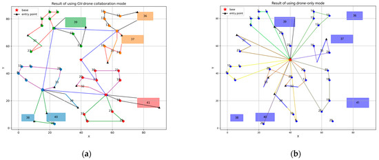
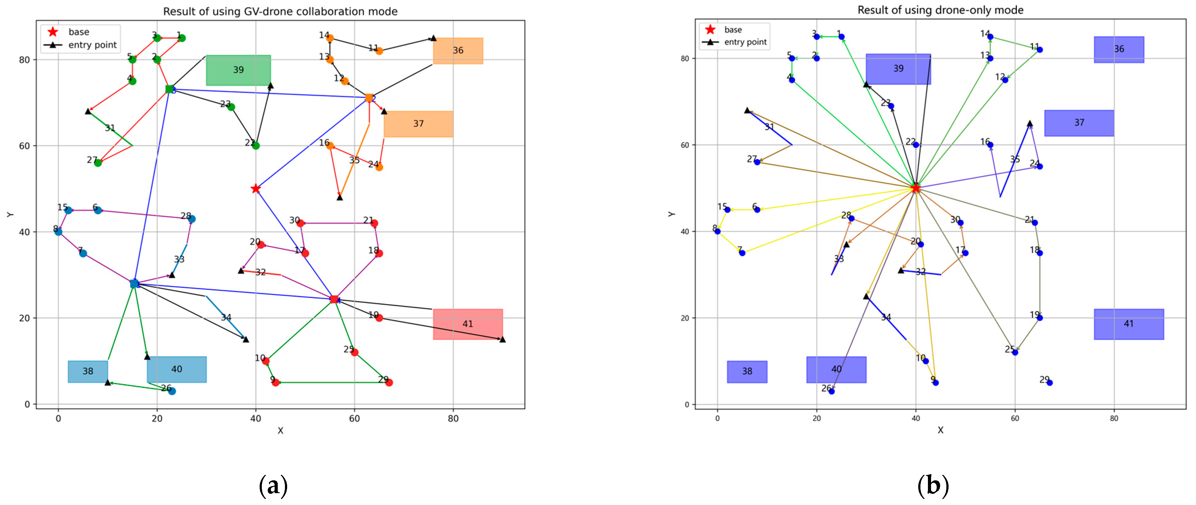
To validate the effectiveness and necessity of the proposed GV–drone collaboration mode, we conducted comparative experiments on instance A8 using the proposed collaboration mode and the drone-only mode. As shown in Figure 7b, the drone-only mode fails to cover some distant targets, and each round trip by a drone can only cover very few targets, resulting in extremely low reconnaissance efficiency. In contrast, as illustrated in Figure 7a, with GV assistance, these issues are effectively addressed, enhancing efficiency while optimizing drone resource utilization.
Figure 7.
Target reconnaissance routes for instance A8. (a) Result of using GV–drone collaboration mode. Each target is marked with its own serial number, and different colors indicate that they belong to different clustering subareas. The closed loop that passes through different targets and is connected by single-arrow line segments represents the route of a single drone. The route that starts from the base, passes through the virtual points (indicated by small squares), and finally returns to the base represents the GV route. (b) Result of using drone-only mode.
5.3. Comparisons with State-of-the-Art Algorithms
In comparison experiments, all algorithms were independently executed 30 times with 200 optimization iterations per run. The comparative analysis considered both the average travel distance (Cost) and computational time (Time (s)) across these trials for each problem instance, with optimal results highlighted in bold in Table 4.
Table 4.
Comparisons Results with state-of-the-art algorithms.
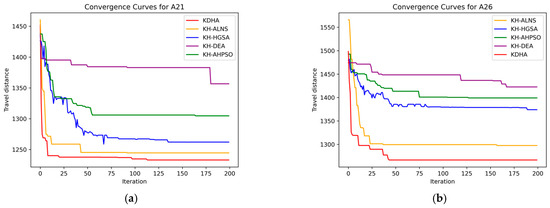
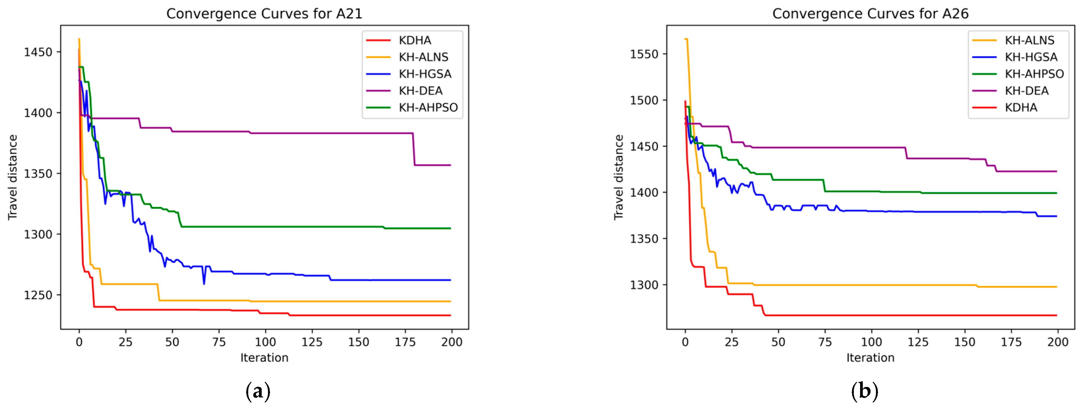
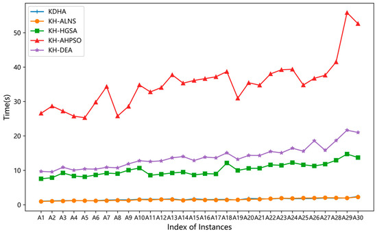
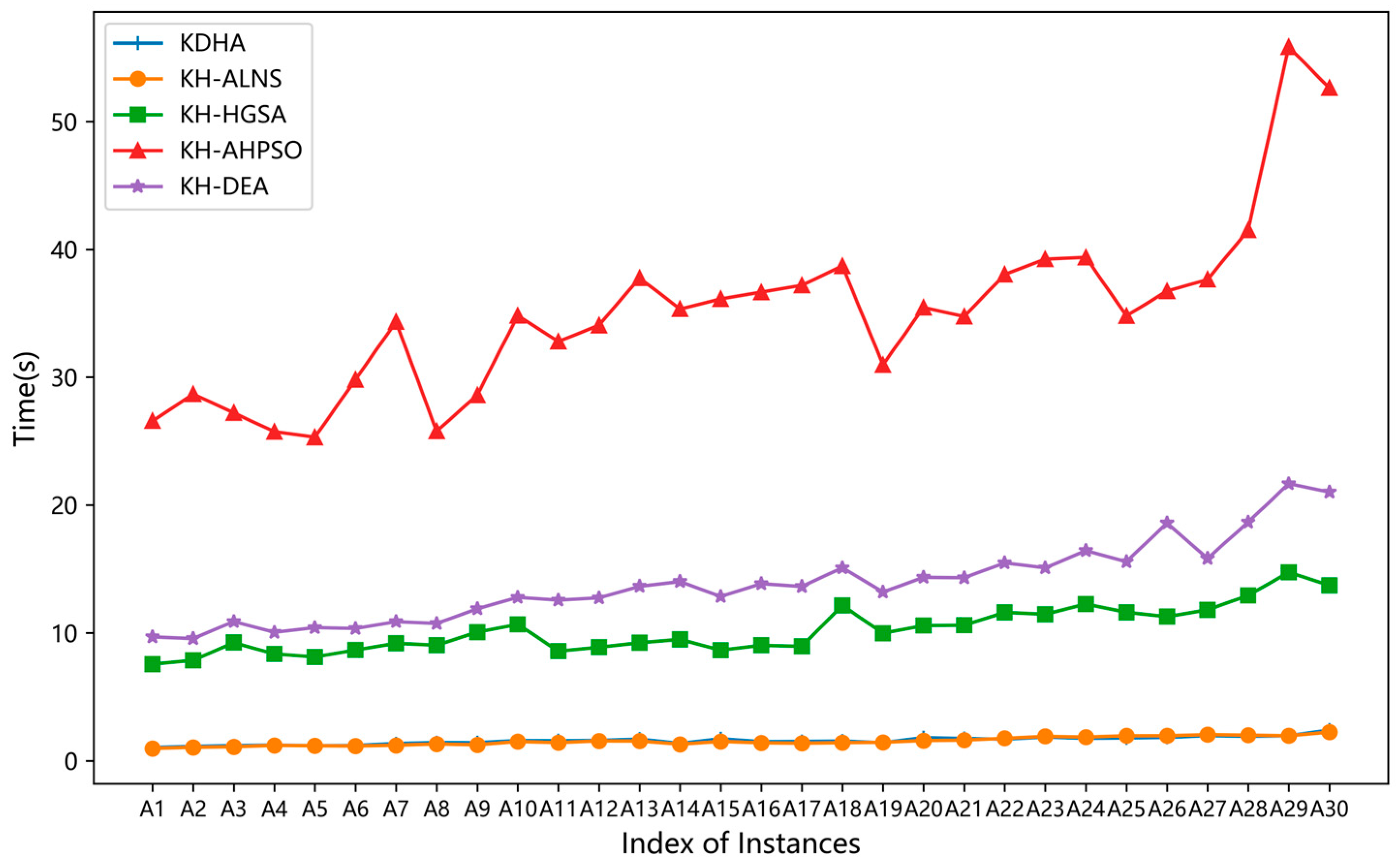
The results in Table 4 demonstrate that KDHA and KH-ALNS require significantly less computation time than the other three algorithms. Notably, KDHA consistently achieves optimal or near-optimal (e.g., A8, A9, A14, A16, and A18) solutions within shorter times, producing optimized travel distance results in 19 problem instances, particularly those involving larger target sets, while KH-HGSA often yields better solutions in other cases. These results can be explained by referring to the convergence curves for some example instances shown in Figure 8 and the runtime of algorithms for instances A1–A30 in Figure 9.
Figure 8.
Convergence curves generated by different algorithms for instances A21 and A26. (a) Convergence curves for instance A21. (b) Convergence curves for instance A26.
Figure 9.
The runtime of algorithms for instances A1–A30.
For scenarios with fewer targets (e.g., A3 and A5), KH-HGSA demonstrates superior performance by rapidly generating diverse solutions through its crossover and mutation operations within the constrained solution space. The incorporated genetic algorithm (SA) enables effective escape from local optima. In these instances, the limited total number of targets leads to significantly reduced target density within each subarea after clustering. This results in fewer generated drone routes during the second stage, thereby preventing adaptive operators that rely on solution space complexity to function effectively. Consequently, the mechanistic advantages of both KDHA and KH-ALNS are substantially diminished. Conversely, in complex scenarios with numerous targets, as shown in the convergence curves of A21 and A26 in Figure 8, KDHA and KH-ALNS leverage their adaptive mechanisms to better utilize search process information. These algorithms dynamically adjust operation probabilities while strategically accepting suboptimal solutions to avoid local optima. The population-based initialization strategy provides KDHA with superior starting solutions compared to KH-ALNS. These observations indicate that the proposed KDHA exhibits increasingly significant advantages as the problem complexity grows, enabling it to obtain higher-quality solutions. Furthermore, the multi-level acceptance strategy and operators incorporating problem-specific knowledge of KDHA jointly enhance its solution space exploration capability, as evidenced by its generally better performance over KH-ALNS in Table 4. This highlights the importance of maintaining a balance between exploration and exploitation in complex routing problems.
From the perspective of algorithm execution time, the adaptive mechanism of KDHA and KH-ALNS reduces the time wasted on invalid or inefficient operations, enabling the algorithms to focus more rapidly on promising search directions, thus shortening execution time. Due to its population-based initialization strategy, KDHA requires a slightly longer time than KH-ALNS to generate more individuals to obtain a higher-quality initial solution. In contrast, KH-HGSA, KH-AHPSO, and KH-DEA require optimization of all population individuals in each iteration, which generally consumes more time. Additionally, from Figure 9, it can be observed that as the number of targets increases and the distribution of targets becomes more complex, the difficulty of solving the problem also increases, leading to a general increase in runtime for all algorithms. However, KDHA maintains a more favorable trade-off between computational overhead and solution quality under increased complexity. It achieves better solution performance with a more moderate increase in runtime compared to other algorithms.
To further compare KDHA with KH-ALNS, KH-HGSA, KH-AHPSO, and KH-DEA, we selected 11 instances (A20–A30) for analysis in terms of both solution gap and coefficient of variation (C.V.). The gap value is used to describe the difference between KDHA and the other algorithms, with KDHA as the baseline algorithm. In addition, the coefficient of variation, which is the ratio of the standard deviation of the travel distance to the average travel distance for each instance, is used to reflect the robustness of the algorithm.
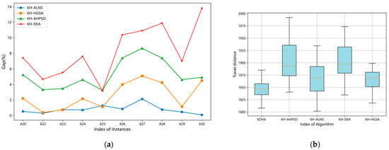
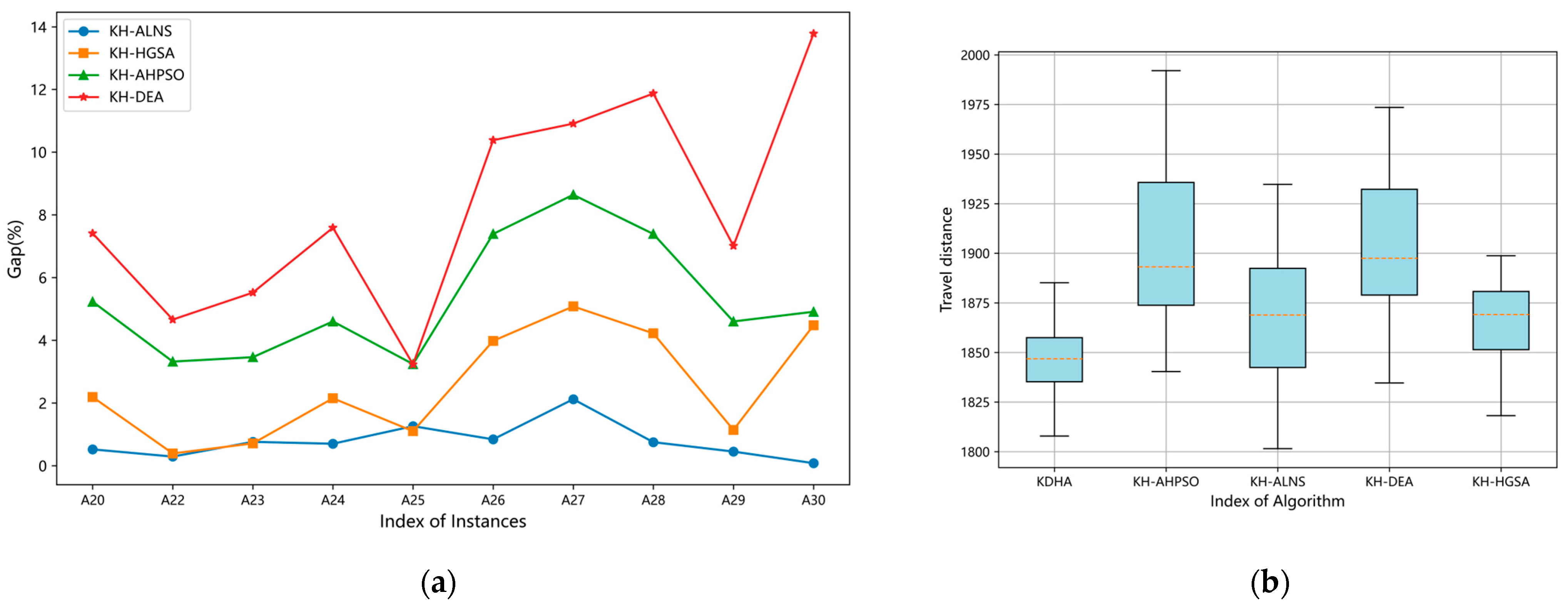
Table 5 and Figure 10a illustrate the performance gap in travel distance between KDHA and the other algorithms. The results clearly show that KDHA produces significantly better solutions than KH-HGSA, KH-AHPSO, and KH-DEA, with KH-ALNS being the only competitor occasionally approaching its performance. This advantage stems from several key factors. Unlike KH-HGSA, KH-AHPSO, and KH-DEA, which depend on multiple parameters that are difficult to optimize for complex multi-target reconnaissance scenarios, KDHA benefits from a more robust and adaptive search mechanism. In addition, the former algorithms exhibit obvious deficiencies in local search capability. KDHA leverages efficient destroy-and-repair operations to fully explore the neighborhood space, thereby obtaining higher-quality solutions. Although KH-ALNS also adopts a similar mechanism, its optimization performance is relatively weaker because it does not incorporate the problem-specific knowledge and multi-level acceptance strategy possessed by KDHA.
Table 5.
Gap and C.V. of algorithms for instances A20–A30.
Figure 10.
Performance variation between algorithms. (a) Gap values of comparison algorithms for instances A20–A30. (b) Results of all algorithms for instance A24.
Table 5 demonstrates that KDHA achieves a significantly lower C.V. in travel distance compared with KH-ALNS, KH-HGSA, KH-AHPSO, and KH-DEA across most instances, highlighting its superior performance in terms of robustness. To provide a more intuitive performance comparison, we examine the results from 30 independent runs using instance A24 as a representative case. Figure 10b reveals that KDHA exhibits the smallest fluctuation range in travel distance while consistently maintaining the shortest travel distance, demonstrating superior algorithm stability. KH-HGSA displays moderate dispersion characteristics, with both its travel distance and fluctuations at an intermediate level, followed closely by KH-ALNS. In contrast, both KH-DEA and KH-AHPSO yield results featuring not only longer travel distances but also more significant fluctuations. This observation can be mainly attributed to the adaptive search mechanism and problem-specific operators of KDHA, which contribute to more stable optimization behavior across different runs.
5.4. Impact Analysis of Target Proportion
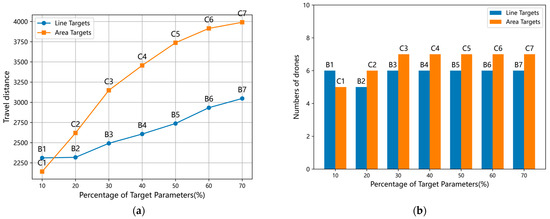
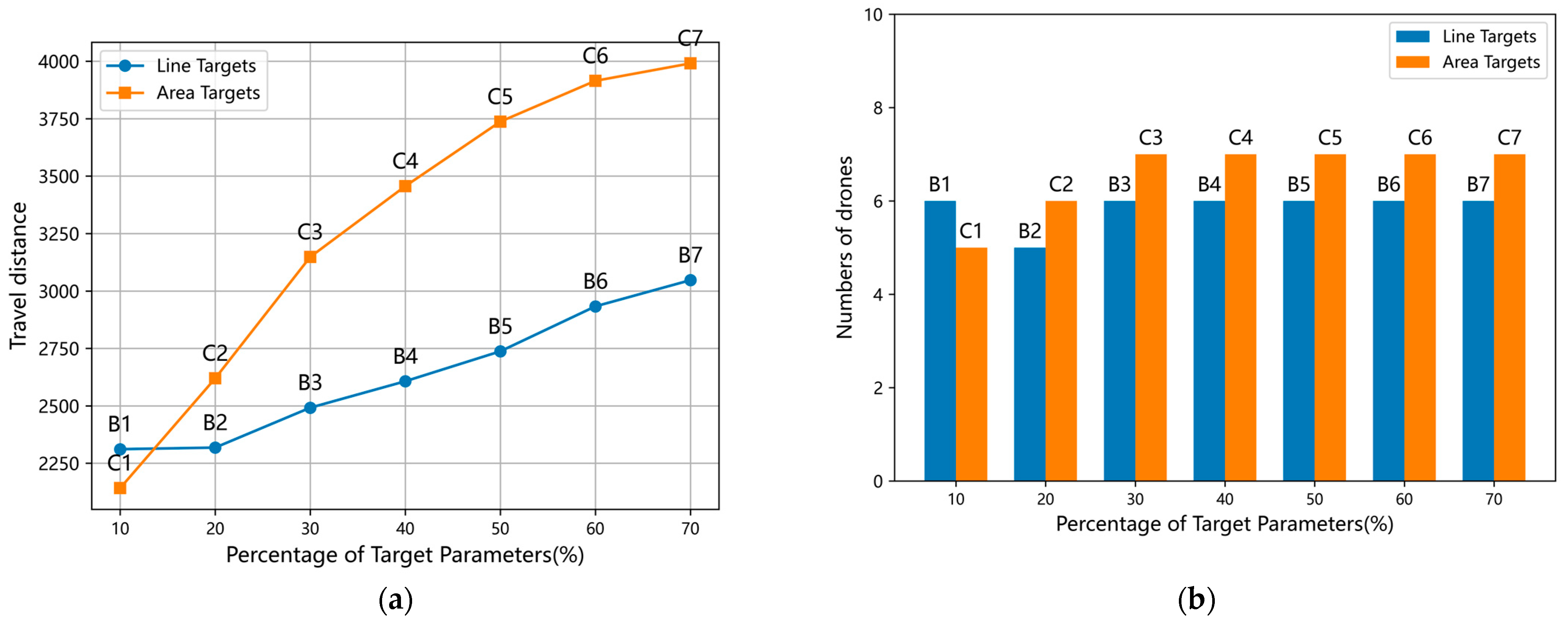
For each problem instance, KDHA is run 30 times, and the maximum number of drones used in each cluster subarea during target reconnaissance is determined as the number of drones required to complete the full coverage for that instance. The changes in travel distance and number of drones are illustrated in Figure 11.
Figure 11.
Impacts of the target radio on cost. (a) Travel distance for instances B1-B7 and C1–C7. (b) Numbers of drones for instances B1–B7 and C1–C7.
From Figure 11, a significant phenomenon can be observed: both the travel distance and drone demand for instances C1–C7 are substantially higher than those for B1–B7 (except for C1 and C6), with a more pronounced cost growth trend compared to B1–B7. This phenomenon is primarily attributed to the higher proportion of area targets in C1–C7, which significantly increases both the travel distance for target coverage and drone requirements. In contrast, the variation in line target proportion in B1–B7 has a relatively minor impact on drone demands, as their coverage travel distance is equivalent to the distance between two-point targets. This distinct difference demonstrates that the geometric characteristics of area targets necessitate greater resource investment to ensure full coverage. Furthermore, we observe that as the proportion of the two types of targets increases, the demand for drones does not increase significantly, demonstrating that the two-stage method effectively optimizes drone resource utilization in practical reconnaissance operations.
5.5. Ablation Study
To further validate the core contribution of domain-specific knowledge to algorithm performance, we design ablation experiments targeting the key repair operator in KDHA. Specifically, we remove the two core components that embed domain knowledge, each in a separate variant. Two variant models are constructed: one variant, obtained by removing the greedy target operator from KDHA, is named NKG-ALNS; the other variant, obtained by removing the random target operator from KDHA, is named NKR-ALNS. The experiments are conducted on the B series and C series datasets. The results are shown in Table 6.
Table 6.
Results of ablation study.
As shown in Table 6, with the increasing proportion of line targets (B1–B7) or area targets (C1–C7), the performance gap in total cost between the two variants and the full KDHA gradually widens. This result strongly validates the significance of domain knowledge. When the number of complex targets with strong geometric constraints increases, the absence of either knowledge-based repair mechanism is more likely to cause suboptimal insertions. This subsequently forces drones to deviate from the backbone routes and make long-distance detours. Additionally, regarding computational overhead, the average runtime of KDHA is slightly longer than that of the variants. This is mainly because the sorting of target types consumes a certain amount of time. The results show that this reasonable time investment effectively limits inefficient searches within massive infeasible solution spaces. Therefore, it achieves better routing quality without imposing a significant computational burden.
Further comparison of the two variants reveals that the performance degradation caused by NKG-ALNS is slightly higher than that of NKR-ALNS in most instances. This phenomenon reasonably reflects the complementary functions of two operators within the heuristic search framework. The greedy target repair operator calculates the physical insertion positions that minimize the total distance increase. This enhances the local exploitation capability of KDHA and guides it to converge quickly toward high-quality solutions. In contrast, the random target repair operator also follows the target processing order determined by domain knowledge. However, it introduces a random mechanism in position selection. Its core purpose is not to directly generate the shortest route but to maintain solution diversity during iterations. This provides the KDHA with the global exploration capability to escape local optima. Ultimately, the coexistence of both operators balances the convergence efficiency and the breadth of solution space exploration of KDHA.
5.6. Impact Analysis of Algorithm Parameters
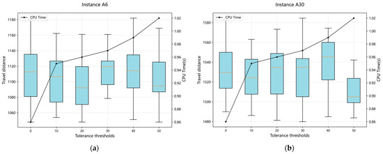
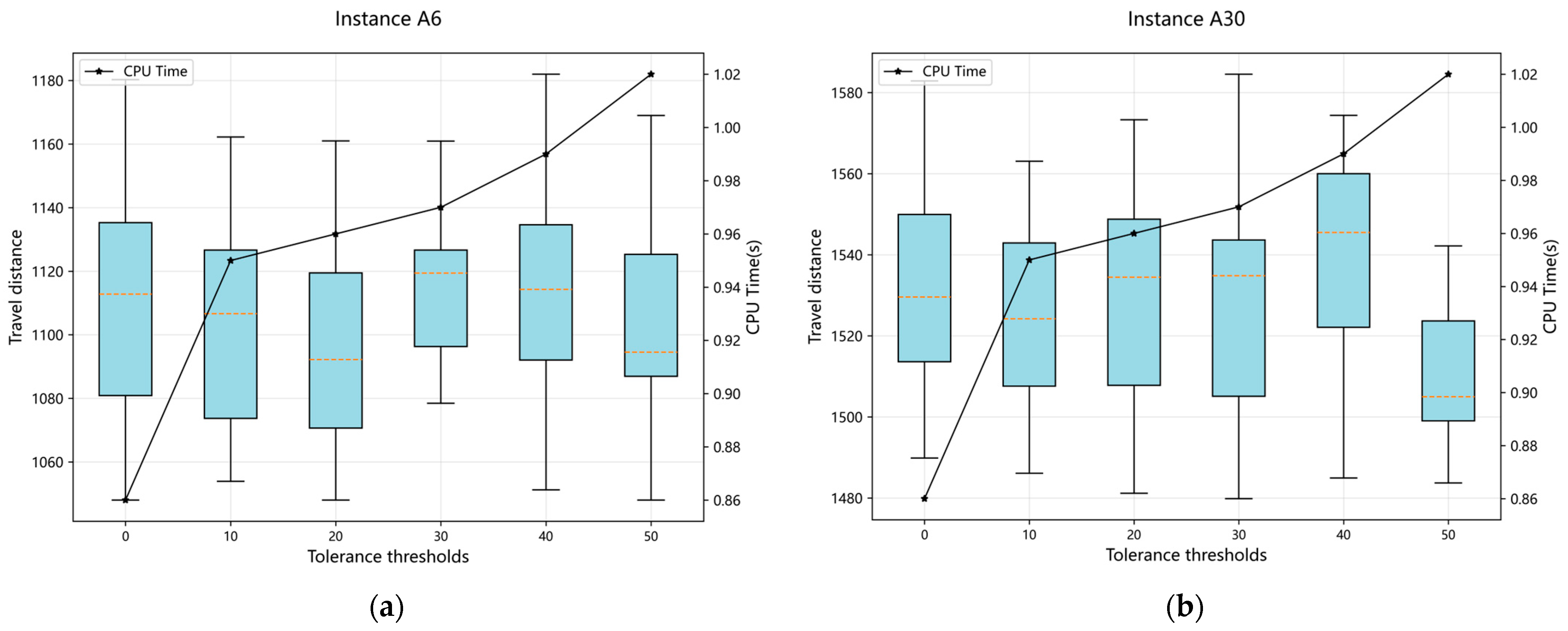
From Figure 12, it can be observed that the impacts of the tolerance threshold, , on KDHA exhibit significantly divergent characteristics depending on the problem scale. When addressing small-scale problems containing fewer targets, a relatively conservative tolerance threshold can optimize solution quality within a certain computing time, while exceeding this threshold leads to obvious efficiency degradation. Conversely, for large-scale problems containing more targets, higher tolerance values improve solution quality but necessitate balancing computing time.
Figure 12.
Impacts of the tolerance threshold, . (a) Results for instance A6. (b) Results for instance A30.
The above phenomenon can be explained from the perspective of algorithm search behavior. For small-scale problems, the search space is relatively small, and KDHA requires high solution accuracy. A smaller enables the algorithm to perform a more fine-grained local search near the target values, which helps to find high-quality solutions. However, when exceeds a certain critical value, KDHA prematurely accepts solutions with large deviations, causing the search direction to diverge and effective computational resources to be wasted in low-quality regions, leading to a significant degradation in solution quality. For large-scale problems, the search space becomes larger and contains numerous local optima. A larger allows the algorithm to accept suboptimal solutions in the early stage, thereby enhancing global exploration capability and avoiding entrapment in local optima, ultimately improving solution quality. However, if is too large, the algorithm performs almost no fine-tuning and converges slowly, thus requiring a trade-off between computational time and solution quality.
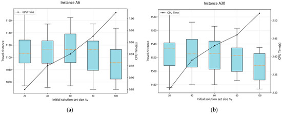
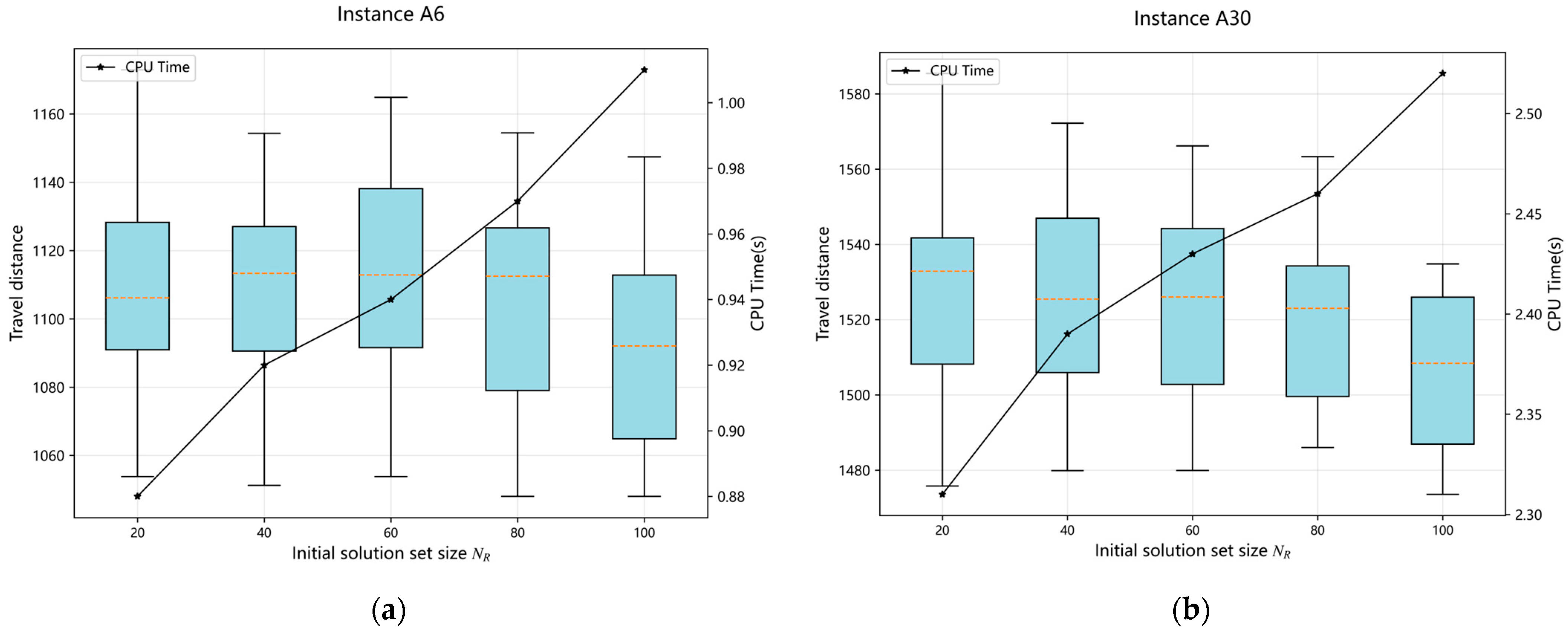
From Figure 13, it can be found that as the initial solution set size, , increases to 100, the travel distance shows modest reductions across different problem instances. This is because a moderate increase in enriches the diversity of initial solutions, helping the KDHA explore more promising regions in the early stage and achieve a slight improvement in solution quality. However, a continuous increase brings only marginal gains in solution performance yet inevitably raises the computational overhead due to the growing number of initial solutions involved in the optimization process. Therefore, an appropriate size for the initial solution set should be selected to balance solution quality and computational efficiency.
Figure 13.
Impacts of the initial solution set size, . (a) Results for instance A6. (b) Results for instance A30.
6. Conclusions
In this paper, we introduce a GVD-MTR. Unlike conventional drone-only or single-type target reconnaissance problems, GVD-MTR explicitly integrates GV–drone collaboration with simultaneous reconnaissance of point, line, and area targets, which better aligns with real-world scenarios. To address GVD-MTR, we propose a KDHA. In the GV routing stage, K-means clustering combined with heuristic operators is applied to generate optimal routes for the GV. In the drone routing stage, an IALNS method is designed to produce optimized drone flight plans. Exquisite strategies, including a population-based initialization strategy, problem-specific destroy and repair, and a multi-level acceptance strategy, are designed to efficiently explore the solution space while keeping the balance between diversification and intensification. Domain knowledge, such as the impact of target type on the total travel distance, is incorporated into the design of search operators to further improve the search capability. The efficiency and robustness of KDHA are validated by extensive experiments, from which we can draw the following conclusions. First, the comparative analysis with drone-only models demonstrates that the GV–drone collaborative mode effectively achieves comprehensive coverage of all targets. Then, when benchmarked against four other heuristic algorithms (KH-ALNS, KH-HGSA, KH-AHPSO, and KH-DEA), KDHA exhibits superior solution quality and computational efficiency across most problem instances. Finally, the parameter sensitivity analyses, including line/area target ratios, the initial solution set size, and tolerance thresholds, further validate KDHA’s robust performance conclusively.
Based on the above research in this paper, we provide two key managerial insights:
- In target reconnaissance scenarios, deciders should not be limited to the drone-only mode but can fully leverage the GV–drone collaborative mode to efficiently achieve comprehensive coverage of multi-type targets.
- As the proportion of line and area targets increases, the total travel distance of drones will significantly increase, particularly for area targets. Therefore, decision-makers should configure drones with appropriate endurance according to the distribution of targets, enhancing reconnaissance efficiency while preventing resource wastage.
However, several issues warrant further research. For instance, we did not take into account the heterogeneity of drones. Meanwhile, due to practical and regulatory limitations, the proposed approach is not verified via real-world deployments. We will establish a simulation environment combining open map datasets like OpenStreetMap and accurate drone models to further verify the proposed approach in future studies. Furthermore, we plan to investigate a double-level RL collaborative architecture or construct an integrated learning-based optimization framework based on RL, which is expected to improve the algorithm performance and adaptability in large-scale dynamic reconnaissance scenarios.
Patents: A patent application has been filed for the invention described in this manuscript.
Author Contributions
Conceptualization, Q.L. and X.L.; methodology, X.L.; validation, X.L.; formal analysis, X.L.; investigation, T.L.; resources, G.W.; writing—original draft preparation, X.L.; writing—review and editing, Q.L. and G.W.; funding acquisition, Q.L. All authors have read and agreed to the published version of the manuscript.
Funding
This work was funded in part by the National Natural Science Foundation of China under grants 62403493 and 62373380, in part by the China Postdoctoral Science Foundation under grants GZC20242042 and 2024M763698, and in part by the Natural Science Foundation of Hunan Province under grant 2025JJ10007.
Data Availability Statement
The raw data supporting the conclusions of this article will be made available by the authors on request.
Conflicts of Interest
The authors declare no conflicts of interest.
References
- Khan, A.; Gupta, S.; Gupta, S.K. Emerging UAV technology for disaster detection, mitigation, response, and preparedness. J. Field Robot. 2022, 39, 905–955. [Google Scholar] [CrossRef] [Scilit]
- Lekidis, A.; Anastasiadis, A.G.; Vokas, G.A. Electricity infrastructure inspection using AI and edge platform-based UAVs. Energy Rep. 2022, 8, 1394–1411. [Google Scholar] [CrossRef] [Scilit]
- Asadzadeh, S.; Oliveira, W.J.D.; Filho, C.R.D.S. UAV-based remote sensing for the petroleum industry and environmental monitoring: State-of-the-art and perspectives. J. Pet. Sci. Eng. 2022, 208, 109633. [Google Scholar] [CrossRef] [Scilit]
- Li, J.; Long, B.; Wu, H.; Hu, X.; Wei, X.; Zhang, Z.; Chai, L.; Xie, J.; Mei, H. Rapid Evaluation Model of Endurance Performance and Its Application for Agricultural UAVs. Drones 2022, 6, 186. [Google Scholar] [CrossRef] [Scilit]
- Liang, Y.-J.; Luo, Z.-X. A survey of truck–drone routing problem: Literature review and research prospects. J. Oper. Res. Soc. China 2022, 10, 343–377. [Google Scholar] [CrossRef] [Scilit]
- Diller, J.; Han, Q. Energy-Aware Drone Path Finding with a Fixed-Trajectory Ground Vehicle. ACM J. Auton. Transp. Syst. 2025, 2, 17. [Google Scholar] [CrossRef] [Scilit]
- CGTN. China’s Tech Frontier: BYD and DJI Launch World’s First Vehicle-Mounted Drone System. Available online: https://news.cgtn.com/news/2025-03-03/VHJhbnNjcmlwdDgzMzU1/index.html (accessed on 3 March 2025).
- Chung, S.H.; Sah, B.; Lee, J. Optimization for drone and drone-truck combined operations: A review of the state of the art and future directions. Comput. Oper. Res. 2020, 123, 105004. [Google Scholar] [CrossRef] [Scilit]
- Wu, G.; Fan, M.; Shi, J.; Feng, Y. Reinforcement Learning Based Truck-and-Drone Coordinated Delivery. IEEE Trans. Artif. Intell. 2023, 4, 754–763. [Google Scholar] [CrossRef] [Scilit]
- Salama, M.; Srinivas, S. Joint optimization of customer location clustering and drone-based routing for last-mile deliveries. Transp. Res. Part C Emerg. Technol. 2020, 114, 620–642. [Google Scholar] [CrossRef] [Scilit]
- Xu, B.; Zhao, K.; Luo, Q.; Wu, G.; Pedrycz, W. A GV-drone arc routing approach for urban traffic patrol by coordinating a ground vehicle and multiple drones. Swarm Evol. Comput. 2023, 77, 101246. [Google Scholar] [CrossRef] [Scilit]
- Xia, Y.; Chen, C.; Liu, Y.; Shi, J.; Liu, Z. Two-layer path planning for multi-area coverage by a cooperative ground vehicle and drone system. Expert Syst. Appl. 2023, 217, 119604. [Google Scholar] [CrossRef] [Scilit]
- Boysen, N.; Briskorn, D.; Fedtke, S.; Schwerdfeger, S. Drone delivery from trucks: Drone scheduling for given truck routes. Networks 2018, 72, 506–527. [Google Scholar] [CrossRef] [Scilit]
- Boccia, M.; Mancuso, A.; Masone, A.; Sterle, C. Exact and heuristic approaches for the truck–drone team logistics problem. Transp. Res. Part C Emerg. Technol. 2024, 165, 104691. [Google Scholar] [CrossRef] [Scilit]
- Shima, T.; Rasmussen, S.J.; Sparks, A.G.; Passino, K.M. Multiple task assignments for cooperating uninhabited aerial vehicles using genetic algorithms. Comput. Oper. Res. 2006, 33, 3252–3269. [Google Scholar] [CrossRef] [Scilit]
- Zhu, W.; Li, L.; Teng, L.; Yonglu, W. Multi-UAV reconnaissance task allocation for heterogeneous targets using an opposition-based genetic algorithm with double-chromosome encoding. Chin. J. Aeronaut. 2018, 31, 339–350. [Google Scholar]
- Chen, H.-X.; Nan, Y.; Yang, Y. Multi-UAV reconnaissance task assignment for heterogeneous targets based on modified symbiotic organisms search algorithm. Sensors 2019, 19, 734. [Google Scholar] [CrossRef] [Scilit] [PubMed]
- Li, X.; Lu, X.; Chen, W.; Ge, D.; Zhu, J. Research on UAVs reconnaissance task allocation method based on communication preservation. IEEE Trans. Consum. Electron. 2024, 70, 684–695. [Google Scholar] [CrossRef] [Scilit]
- Gao, S.; Wu, J.; Ai, J. Multi-UAV reconnaissance task allocation for heterogeneous targets using grouping ant colony optimization algorithm. Soft Comput. 2021, 25, 7155–7167. [Google Scholar] [CrossRef] [Scilit]
- Zhang, H.; Miao, K.; Yu, H.; Niu, Y. Multi-UAV Reconnaissance Task Assignment for Heterogeneous Targets with ACD-NSGA-II Algorithm. Electronics 2024, 13, 3609. [Google Scholar] [CrossRef] [Scilit]
- Tian, X.; Xu, T.; Luo, X.; Jia, Y.; Yin, J. Multi-UAV Reconnaissance Task Allocation in 3D Urban Environments. IEEE Access 2024, 12, 30989–30999. [Google Scholar] [CrossRef] [Scilit]
- Xiong, H.; Yao, C.; Liu, J.; Shi, X. Improved multi-objective gray wolf optimization for task allocation in multi-UAV heterogeneous targets reconnaissance. Clust. Comput. 2025, 28, 397. [Google Scholar] [CrossRef] [Scilit]
- Wu, W.; Xu, J.; Sun, Y. Integrate Assignment of Multiple Heterogeneous Unmanned Aerial Vehicles Performing Dynamic Disaster Inspection and Validation Task With Dubins Path. IEEE Trans. Aerosp. Electron. Syst. 2023, 59, 4018–4032. [Google Scholar] [CrossRef] [Scilit]
- Güven, İ; Yanmaz, E. Adaptive Multi-UAV Coordination for Heterogeneous Target Search and Connect Missions Using Proximal Policy Optimization*. In Proceedings of the 2025 IEEE 101st Vehicular Technology Conference (VTC2025-Spring), Oslo, Norway, 17–20 June 2025; IEEE: Piscataway, NJ, USA, 17–20 June 2025; pp. 1–6. [Google Scholar] [CrossRef] [Scilit]
- Murray, C.C.; Chu, A.G. The flying sidekick traveling salesman problem: Optimization of drone-assisted parcel delivery. Transp. Res. Part C Emerg. Technol. 2015, 54, 86–109. [Google Scholar] [CrossRef] [Scilit]
- Murray, C.C.; Raj, R. The multiple flying sidekicks traveling salesman problem: Parcel delivery with multiple drones. Transp. Res. Part C Emerg. Technol. 2020, 110, 368–398. [Google Scholar] [CrossRef] [Scilit]
- Zhai, R.; Mei, Y.; Guo, T.; Du, W. A Collaborative Drone-Truck Delivery System With Memetic Computing Optimization. IEEE Trans. Syst. Man Cybern. Syst. 2024, 54, 3618–3630. [Google Scholar] [CrossRef] [Scilit]
- Luo, Y.; Deng, X.; Zhang, W.; Ke, Y.; Wan, S.; Qian, Y. Collaborative Intelligent Delivery With One Truck and Multiple Heterogeneous Drones in COVID-19 Pandemic Environment. IEEE Trans. Intell. Transp. Syst. 2024, 25, 7907–7920. [Google Scholar] [CrossRef] [Scilit]
- Wu, G.; Mao, N.; Luo, Q.; Xu, B.; Shi, J.; Suganthan, P.N. Collaborative Truck-Drone Routing for Contactless Parcel Delivery During the Epidemic. IEEE Trans. Intell. Transp. Syst. 2022, 23, 25077–25091. [Google Scholar] [CrossRef] [Scilit]
- Luo, Q.; Wu, G.; Trivedi, A.; Hong, F.; Wang, L.; Srinivasan, D. Multi-objective optimization algorithm with adaptive resource allocation for truck-drone collaborative delivery and pick-up services. IEEE Trans. Intell. Transp. Syst. 2023, 24, 9642–9657. [Google Scholar] [CrossRef] [Scilit]
- Bogyrbayeva, A.; Dauletbayev, B.; Meraliyev, M. Reinforcement Learning for Efficient Drone-Assisted Vehicle Routing. Appl. Sci. 2025, 15, 2007. [Google Scholar] [CrossRef] [Scilit]
- Tian, S.; Wen, X.; Wei, B.; Wu, G. Cooperatively Routing a Truck and Multiple Drones for Target Surveillance. Sensors 2022, 22, 2909. [Google Scholar] [CrossRef] [Scilit]
- Momeni, M.; Soleimani, H.; Shahparvari, S.; Afshar-Nadjafi, B. Coordinated routing system for fire detection by patrolling trucks with drones. Int. J. Disaster Risk Reduct. 2022, 73, 102859. [Google Scholar] [CrossRef] [Scilit]
- Cheng, J.; Liao, T.; Wu, G.; Ma, Z.; Shi, J. Two-Echelon Arc Routing Problem With Drones in Traffic Patrol. IEEE Trans. Autom. Sci. Eng. 2025, 22, 17170–17188. [Google Scholar] [CrossRef] [Scilit]
- Liu, Y.; Shi, J.; Liu, Z.; Huang, J.; Zhou, T. Two-Layer Routing for High-Voltage Powerline Inspection by Cooperated Ground Vehicle and Drone. Energies 2019, 12, 1385. [Google Scholar] [CrossRef] [Scilit]
- Jayaweera, H.M.P.C.; Hanoun, S. UAV Path Planning for Reconnaissance and Look-Ahead Coverage Support for Mobile Ground Vehicles. Sensors 2021, 21, 4595. [Google Scholar] [CrossRef] [Scilit]
- Savkin, A.V.; Huang, H. Multi-UAV Navigation for Optimized Video Surveillance of Ground Vehicles on Uneven Terrains. IEEE Trans. Intell. Transp. Syst. 2023, 24, 10238–10242. [Google Scholar] [CrossRef] [Scilit]
- Miranda-Bront, J.J.; Curcio, B.; Méndez-Díaz, I.; Montero, A.; Pousa, F.; Zabala, P. A cluster-first route-second approach for the swap body vehicle routing problem. Ann. Oper. Res. 2017, 253, 935–956. [Google Scholar] [CrossRef] [Scilit]
- Gedikli, T.; Karaoğlan, İ. Two-Echelon Location Selection and Unmanned Aerial Vehicle Assisted Vehicle Routing Problem. J. Transp. Logist. 2025, 10, 1–17. [Google Scholar] [CrossRef] [Scilit]
- Weng, X.; She, W.; Fan, H.; Zhang, J.; Yun, L. Multi-depot vehicle routing problem with drones in emergency logistics. Clust. Comput. 2025, 28, 64. [Google Scholar] [CrossRef] [Scilit]
- Luo, Z.; Poon, M.; Zhang, Z.; Liu, Z.; Lim, A. The multi-visit traveling salesman problem with multi-drones. Transp. Res. Part C Emerg. Technol. 2021, 128, 103172. [Google Scholar] [CrossRef] [Scilit]
- Muyldermans, L.; Beullens, P.; Cattrysse, D.; Van Oudheusden, D. Exploring variants of 2-opt and 3-opt for the general routing problem. Oper. Res. 2005, 53, 982–995. [Google Scholar] [CrossRef] [Scilit]
- Luo, J.; Heng, H.; Wu, G. Graph attention, learning 2-opt algorithm for the traveling salesman problem. Complex Intell. Syst. 2025, 11, 117. [Google Scholar] [CrossRef] [Scilit]
- Zhang, Z.; Song, X.; Gong, X.; Yin, Y.; Lev, B.; Zhou, X. An effective heuristic based on 3-opt strategy for seru scheduling problems with learning effect. Int. J. Prod. Res. 2023, 61, 1938–1954. [Google Scholar] [CrossRef] [Scilit]
- Goldberg, D.E. Genetic Algorithms in Search, Optimization, and Machine Learning; Addison-Wesley Pub. Co.: Reading, MA, USA, 1989. [Google Scholar]
- Solomon, M.M. Algorithms for the Vehicle Routing and Scheduling Problems with Time Window Constraints. Oper. Res. 1987, 35, 254–265. [Google Scholar] [CrossRef] [Scilit]
- Ropke, S.; Pisinger, D. An Adaptive Large Neighborhood Search Heuristic for the Pickup and Delivery Problem with Time Windows. Transp. Sci. 2006, 40, 455–472. [Google Scholar] [CrossRef] [Scilit]
- Sajid, M.; Jafar, A.; Sharma, S. Hybrid Genetic and Simulated Annealing Algorithm for Capacitated Vehicle Routing Problem. In Proceedings of the 2020 Sixth International Conference on Parallel, Distributed and Grid Computing (PDGC), Solan, India, 6–8 November 2020; IEEE: Piscataway, NJ, USA, 2020; pp. 131–136. [Google Scholar] [CrossRef] [Scilit]
- Zhang, B.; Luo, T.; Zhu, Y.; Chen, Z.; Luo, Y.; Zhou, J.; Xiao, J. A High Efficiency Task Allocation Method Based on Adaptive Hybrid Particle Swarm Optimization for Intelligent Unmanned Wireless Sensor Networks. In Proceedings of the 2024 IEEE 12th International Conference on Information, Communication and Networks (ICICN), Guilin, China, 21–24 August 2024; IEEE: Piscataway, NJ, USA, 2024; pp. 299–305. [Google Scholar] [CrossRef] [Scilit]
- You, X.; Zhang, M.; Yu, Y. Research on Optimization of Traveling Salesman Problem Based on Differential Evolution Algorithm. In Proceedings of the 2022 International Conference on Cloud Computing, Big Data Applications and Software Engineering (CBASE), Suzhou, China, 23–25 September 2022; IEEE: Piscataway, NJ, USA, 2022; pp. 246–249. [Google Scholar] [CrossRef] [Scilit]



Disclaimer/Publisher’s Note: The statements, opinions and data contained in all publications are solely those of the individual author(s) and contributor(s) and not of MDPI and/or the editor(s). MDPI and/or the editor(s) disclaim responsibility for any injury to people or property resulting from any ideas, methods, instructions or products referred to in the content. |
© 2026 by the authors. Licensee MDPI, Basel, Switzerland. This article is an open access article distributed under the terms and conditions of the Creative Commons Attribution (CC BY) license.