You are currently viewing a new version of our website. To view the old version click .

ISPRS International Journal of Geo-Information, Volume 11, Issue 7

July 2022 - 61 articles

Cover Story: 
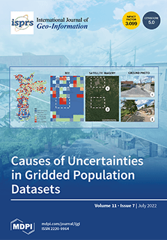
Gridded population datasets (e.g., GHS-POP) show substantial variations in error rates depending on the geographic context. In general, cities in High-Income (HIC) and Upper-Middle-Income Countries (UMIC) have fewer model errors as compared to cities in Low- and Middle-Income Countries (LMIC). According to the global average, 75% of all urban spaces are wrongly estimated. The spatial patterns of errors (i.e., REE) show that in central mixed or non-residential areas, the population is overestimated, while in high-density residential areas (e.g., informal areas or high-rise built-up areas), the population is underestimated. Moreover, high model uncertainties exist in low-density or sparsely populated outskirts of cities. View this paper
  • Issues are regarded as officially published after their release is announced to the table of contents alert mailing list .
  • You may sign up for email alerts to receive table of contents of newly released issues.
  • PDF is the official format for papers published in both, html and pdf forms. To view the papers in pdf format, click on the "PDF Full-text" link, and use the free Adobe Reader to open them.

Articles (61)

  • Article
  • Open Access
15 Citations
4,997 Views
19 Pages

The spatial distribution and accessibility of urban public service facilities affect socioeconomic factors in the lives of residents, especially housing prices. Given that most previous studies focus on the accessibility of a certain, single type of...

  • Article
  • Open Access
4 Citations
3,169 Views
24 Pages

The Reflection of Income Segregation and Accessibility Cleavages in Sydney’s House Prices

  • Matthew Kok Ming Ng,
  • Josephine Roper,
  • Chyi Lin Lee and
  • Christopher Pettit

Cities often show residential income segregation, and the price of housing is generally related to employment accessibility, but how do these factors intersect? We analyse Greater Sydney, Australia, a metropolitan area of 5 million people. Sydney is...

  • Article
  • Open Access
4 Citations
2,663 Views
21 Pages

Similarity Search on Semantic Trajectories Using Text Processing

  • Damião Ribeiro de Almeida,
  • Cláudio de Souza Baptista and
  • Fabio Gomes de Andrade

The use of location-based sensors has increased exponentially. Tracking moving objects has become increasingly common, consolidating a new field of research that focuses on trajectory data management. Such trajectories may be semantically enriched us...

  • Article
  • Open Access
14 Citations
4,506 Views
14 Pages

Parametric and Visual Programming BIM Applied to Museums, Linking Container and Content

  • Massimiliano Lo Turco,
  • Elisabetta Caterina Giovannini and
  • Andrea Tomalini

In recent years we have been experiencing an ever-increasing number of Building Modeling Modeling (BIM) and Visual Programming Language (VPL) approaches in the architectural design field. These experiments have inspired new research strictly focused...

  • Article
  • Open Access
3 Citations
2,722 Views
12 Pages

Where the streets have no name is probably the preferred place for a volunteer OpenStreetMapper. Launched in 2004, the Open Street Map project aimed to share geographical data based on volunteer mapping and led to the collection of geographical data...

  • Article
  • Open Access
10 Citations
3,721 Views
18 Pages

In various applications of blockchain, how to index spatio-temporal data more efficiently has become a subject of continuous attention. The existing spatio-temporal data query in the blockchain is realized by adding additional external storage or fix...

  • Article
  • Open Access
7 Citations
3,569 Views
20 Pages

Human activities can degrade landscape connectivity and disrupt ecological flows, jeopardising the functional integrity of processes. This study presents a quantitative assessment of Asia’s protected areas’ (PAs) structural connectivity u...

  • Article
  • Open Access
33 Citations
5,306 Views
27 Pages

This study aims to extract water surface area and lake surface water temperature (LSWT), and to present long-term spatio-temporal analysis of these variables together with meteorological parameters. Three lakes in Türkiye’s Lakes Region, n...

  • Article
  • Open Access
13 Citations
3,541 Views
15 Pages

The expansion and evolution of urban areas are the most perceptible manifestations of the transformation of the urban spatial form. This study uses remote sensing images of Nanjing from 2001, 2006, 2011, 2016, and 2021, along with socio-economic data...

  • Article
  • Open Access
8 Citations
5,081 Views
15 Pages

The main objective of this research was to develop a web-based geographic information system (GIS) based on a detailed analysis of user preferences from the perspective of forest research, management and education. An anonymous questionnaire was used...

of 7

Get Alerted

Add your email address to receive forthcoming issues of this journal.

XFacebookLinkedIn
ISPRS Int. J. Geo-Inf. - ISSN 2220-9964