
Assessment of Spatio-Temporal Changes in Water Surface Extents and Lake Surface Temperatures Using Google Earth Engine for Lakes Region, Türkiye


Abstract
:1. Introduction
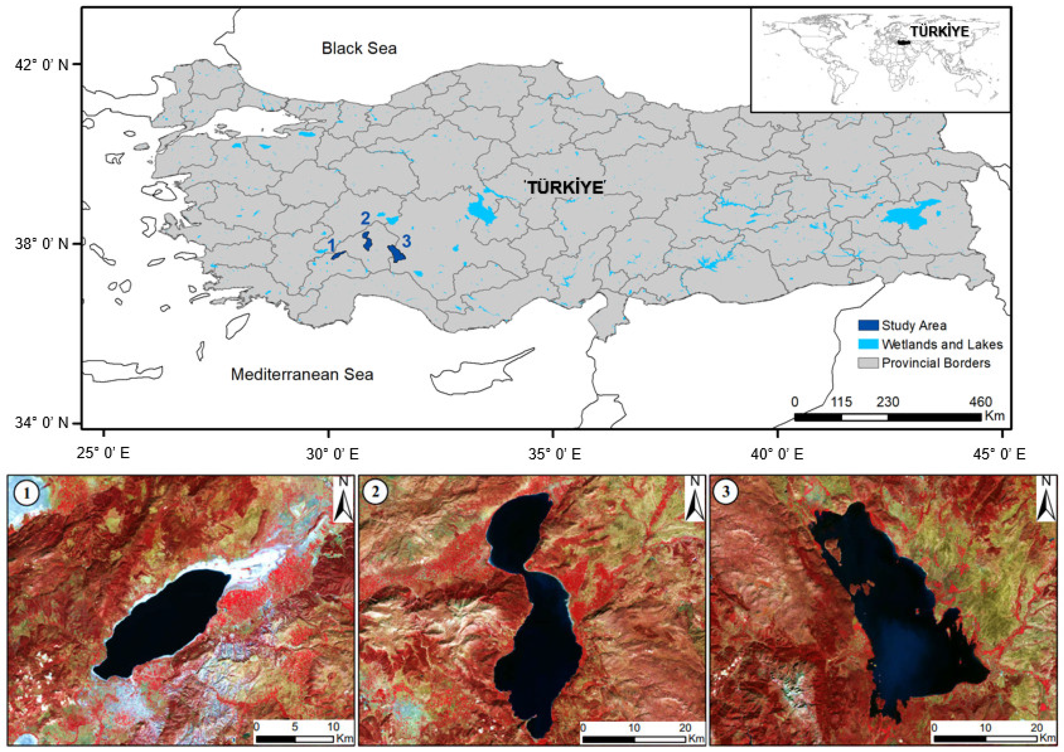
2. Study Area
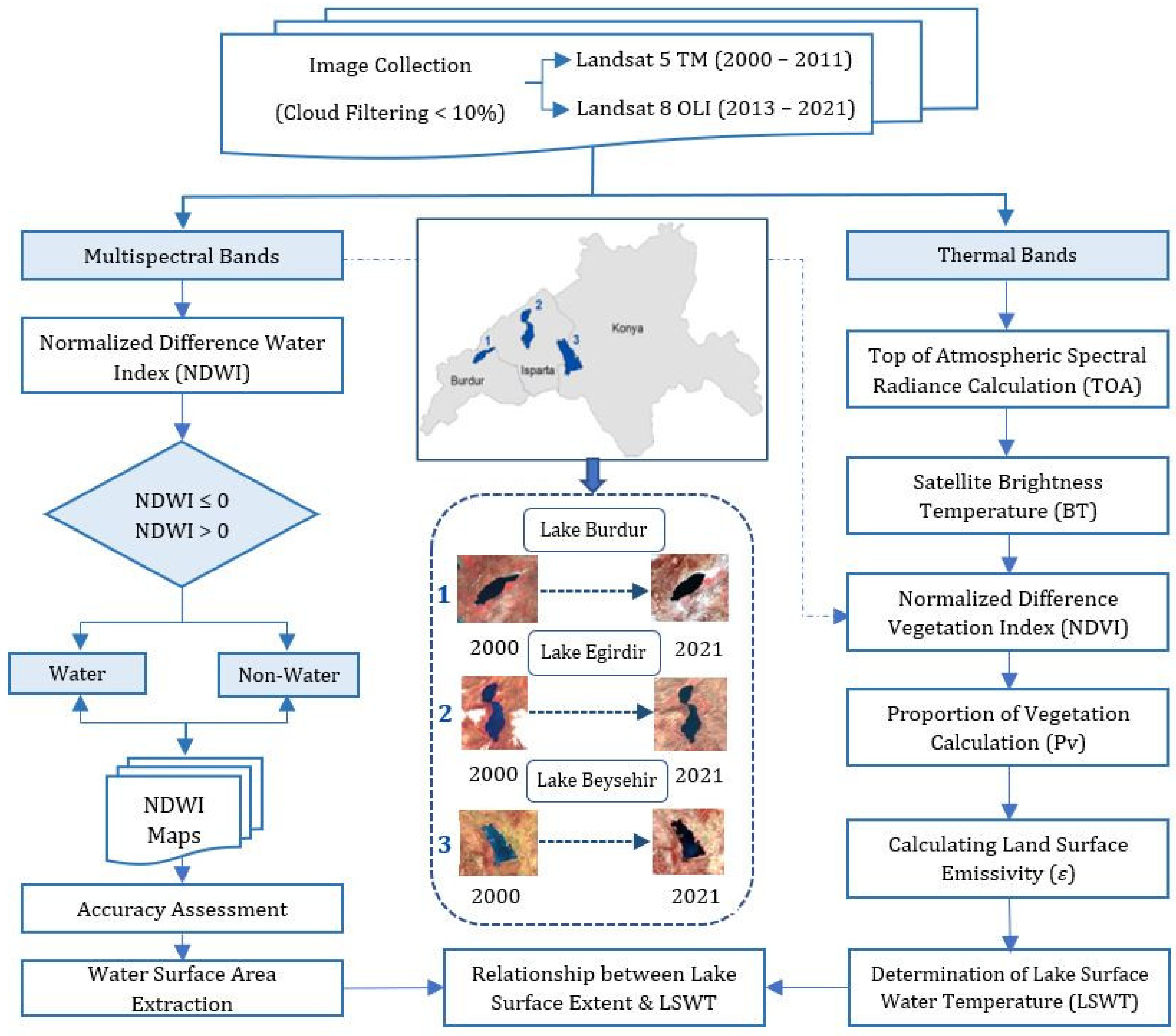
3. Materials and Methods
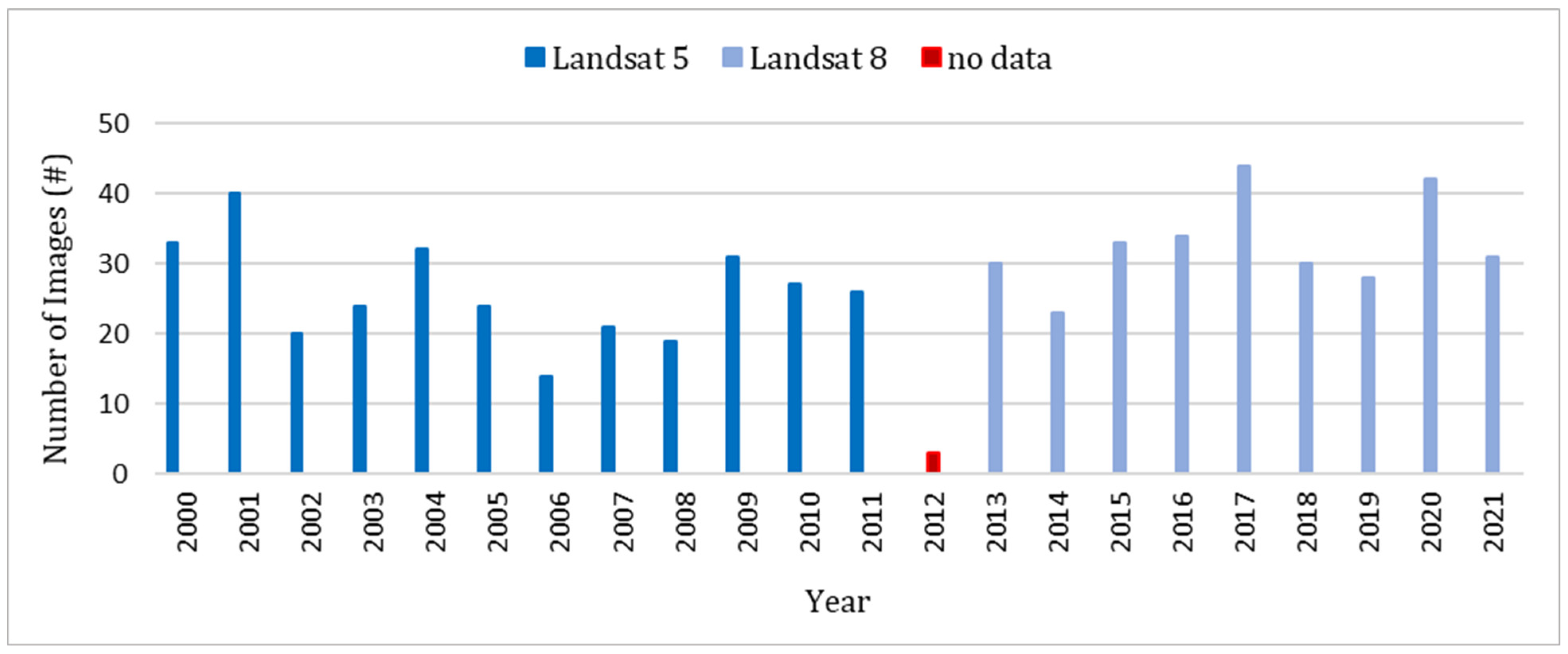
3.1. Materials

| Satellite | Spectral Resolution (µm) | Spatial Resolution (m) | Radiometric Resolution (bit) |
|---|---|---|---|
| Landsat 5 TM (2000–2011) | 6 Optical Bands (0.45–2.35) 1 Thermal Band (10.40-12.50) | Blue, Green, Red, NIR, SWIR1-2: 30 m Thermal Infrared: 120 m | 8 |
| Landsat 8 OLI/TIRS (2013–2021) | 9 Optical Bands (0.43–2.30) 2 Thermal Bands (10.6-12.51) | Cirrus, Coastal/Aerosol, Blue, Green, Red, NIR, SWIR1-2: 30 m Thermal Infrared 1–2: 100 m Panchromatic: 15m | 16 |
3.2. Methods
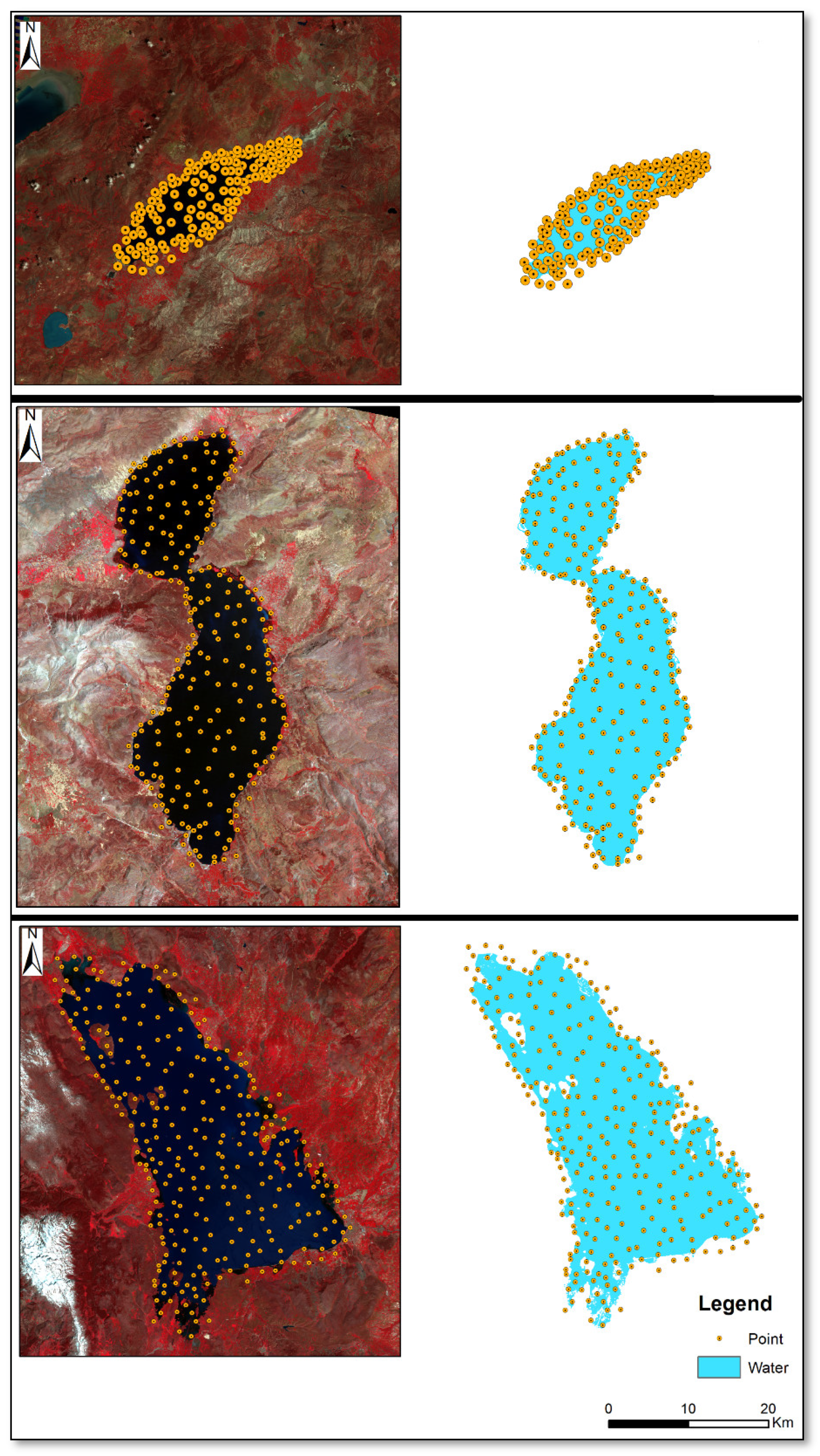
3.2.1. Water Surface Area Extraction
3.2.2. Accuracy Assessment of Extracted Water Surface Area Map
| Category/Class | Reference Data | ||
|---|---|---|---|
| Water | Non-Water | ||
| Classified Data | Water | TP | FP |
| Non-water | FN | TN | |
3.2.3. The Determination of LSWT Variable
4. Results and Discussion
4.1. Accuracy Assessment of Extracted Water Surface Area Map
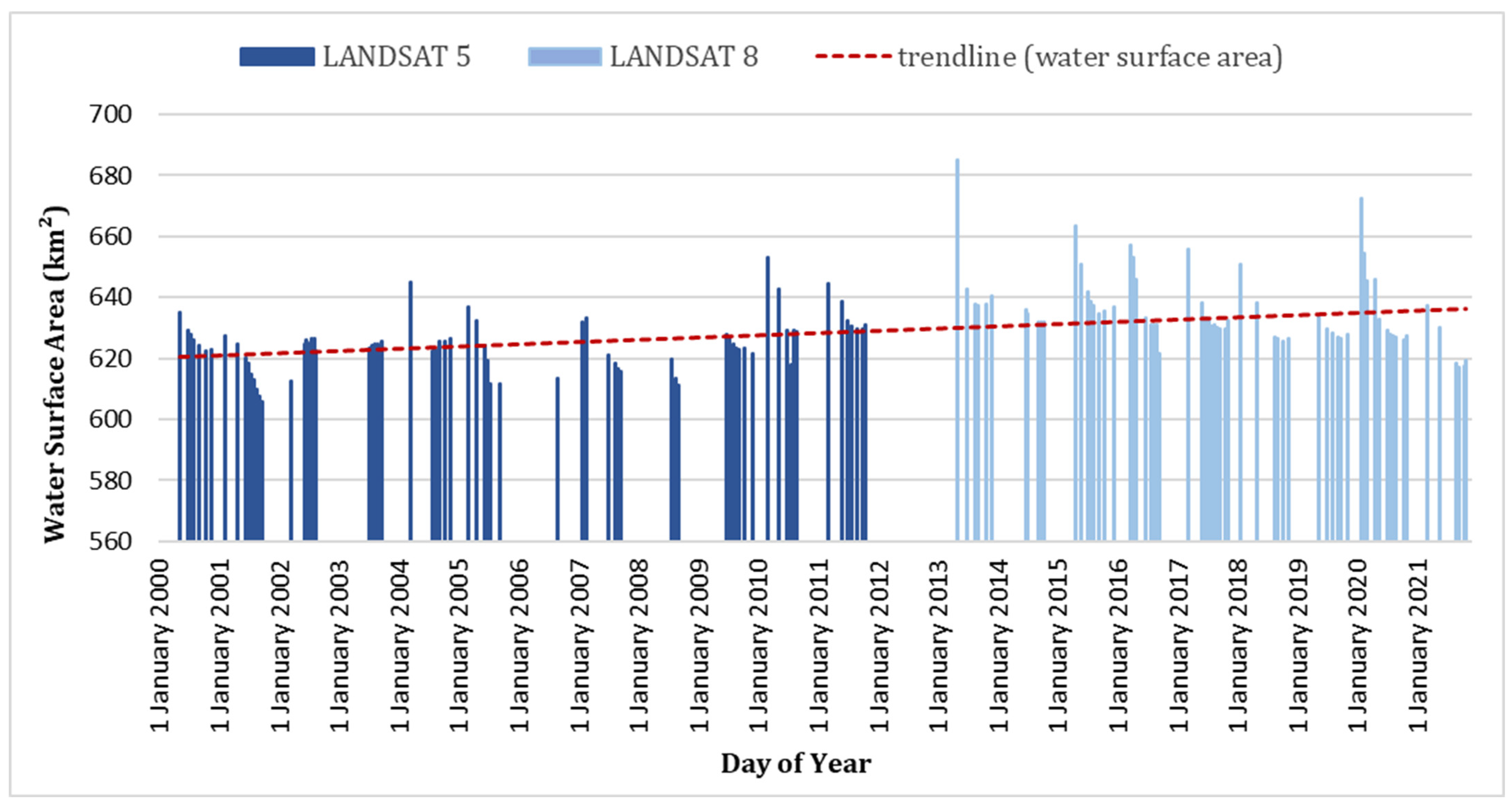
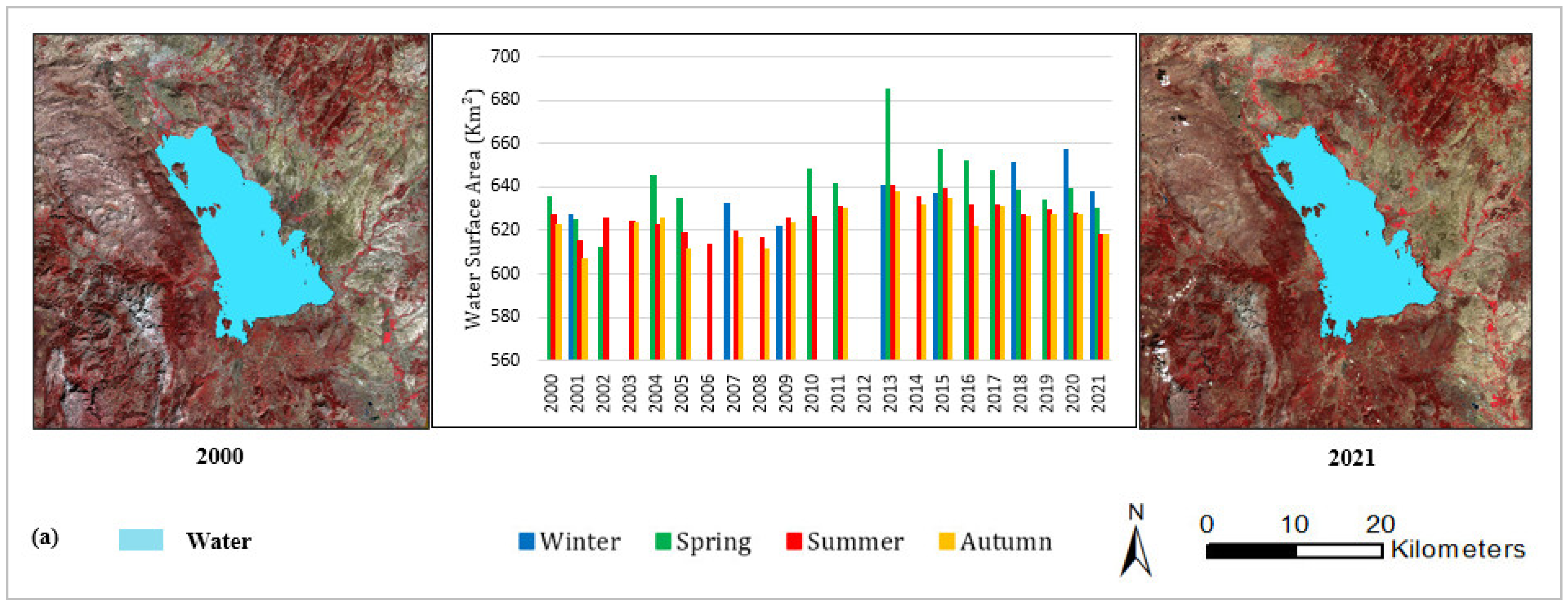
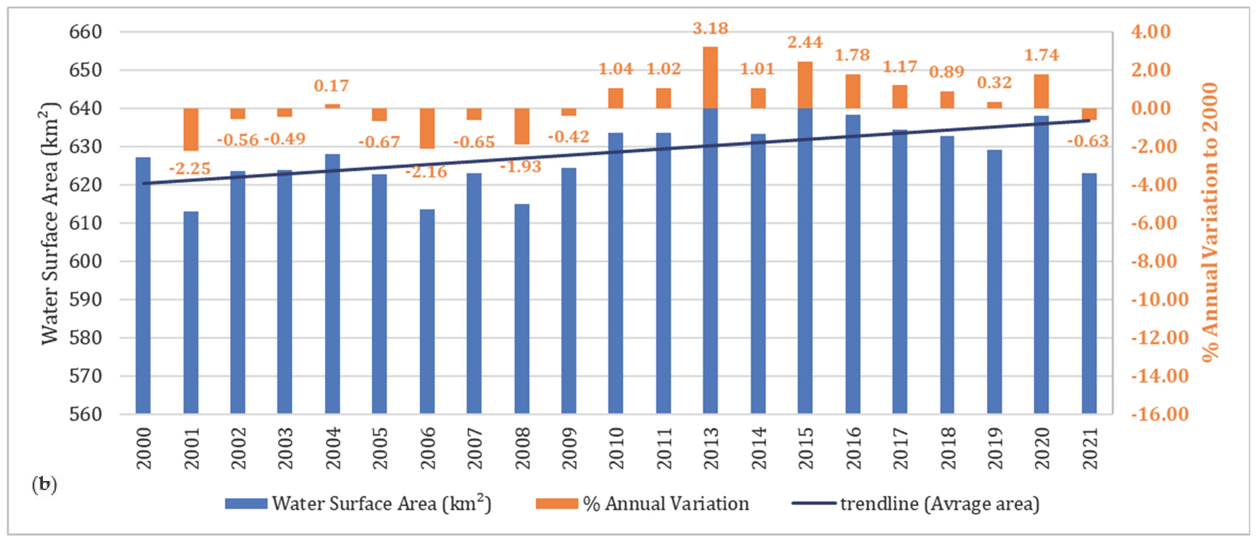
4.2. Spatial and Temporal Changes of Lake Water Extent from 2000 to 2021
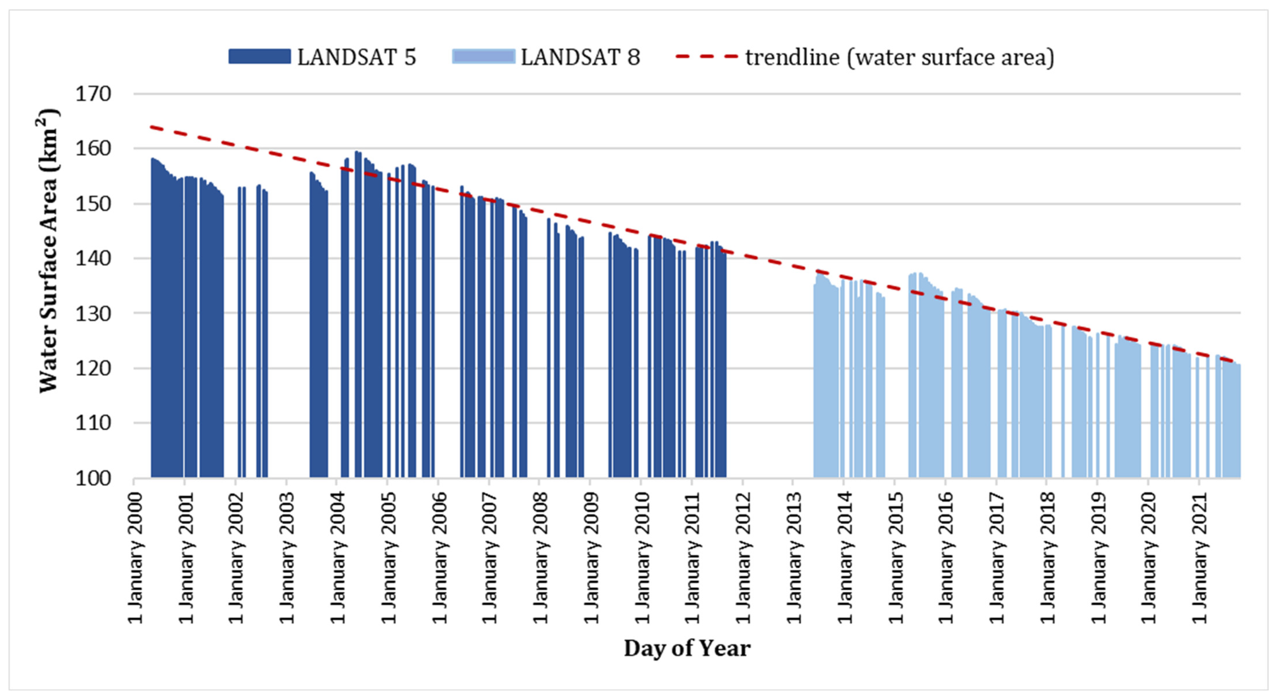
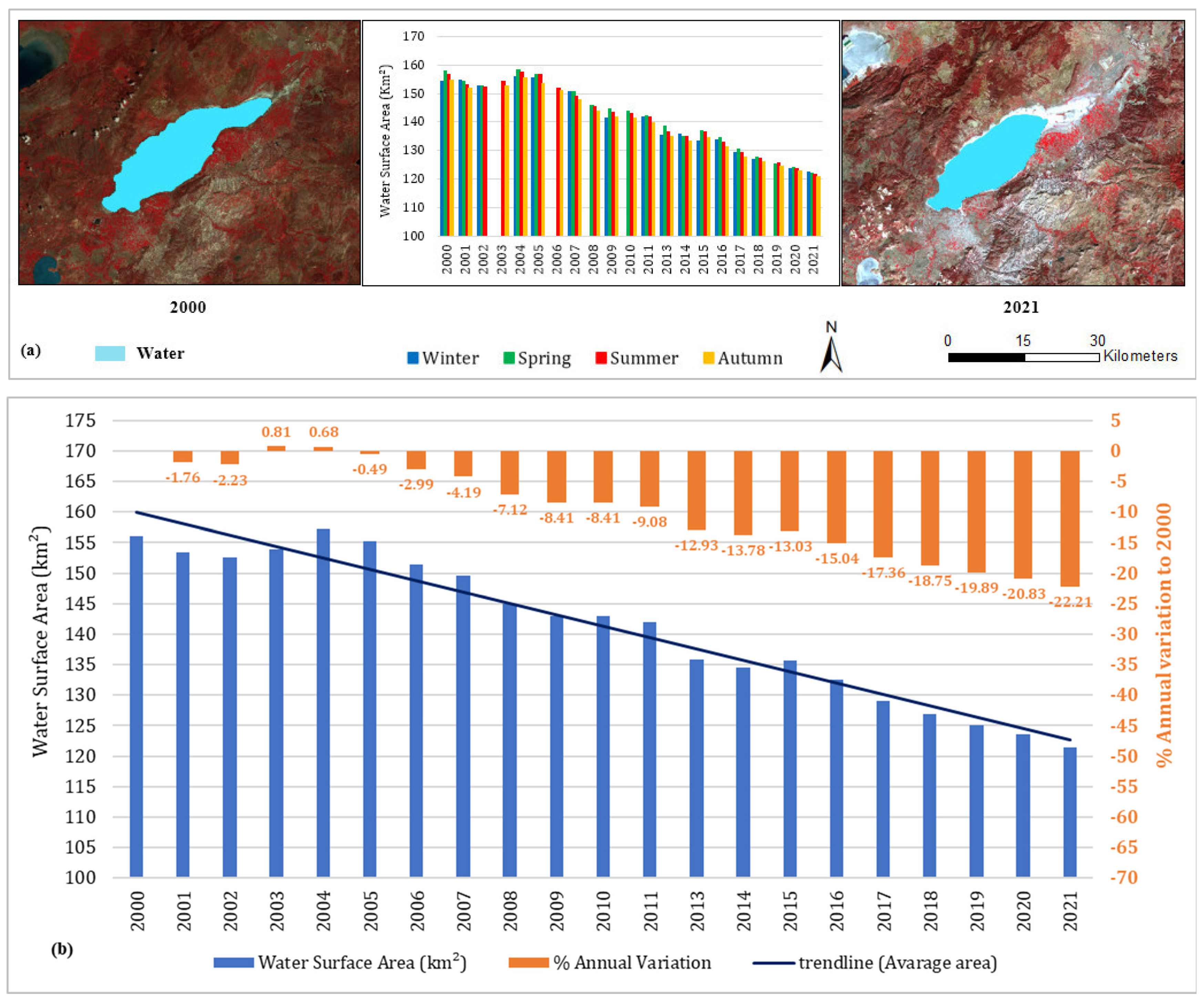
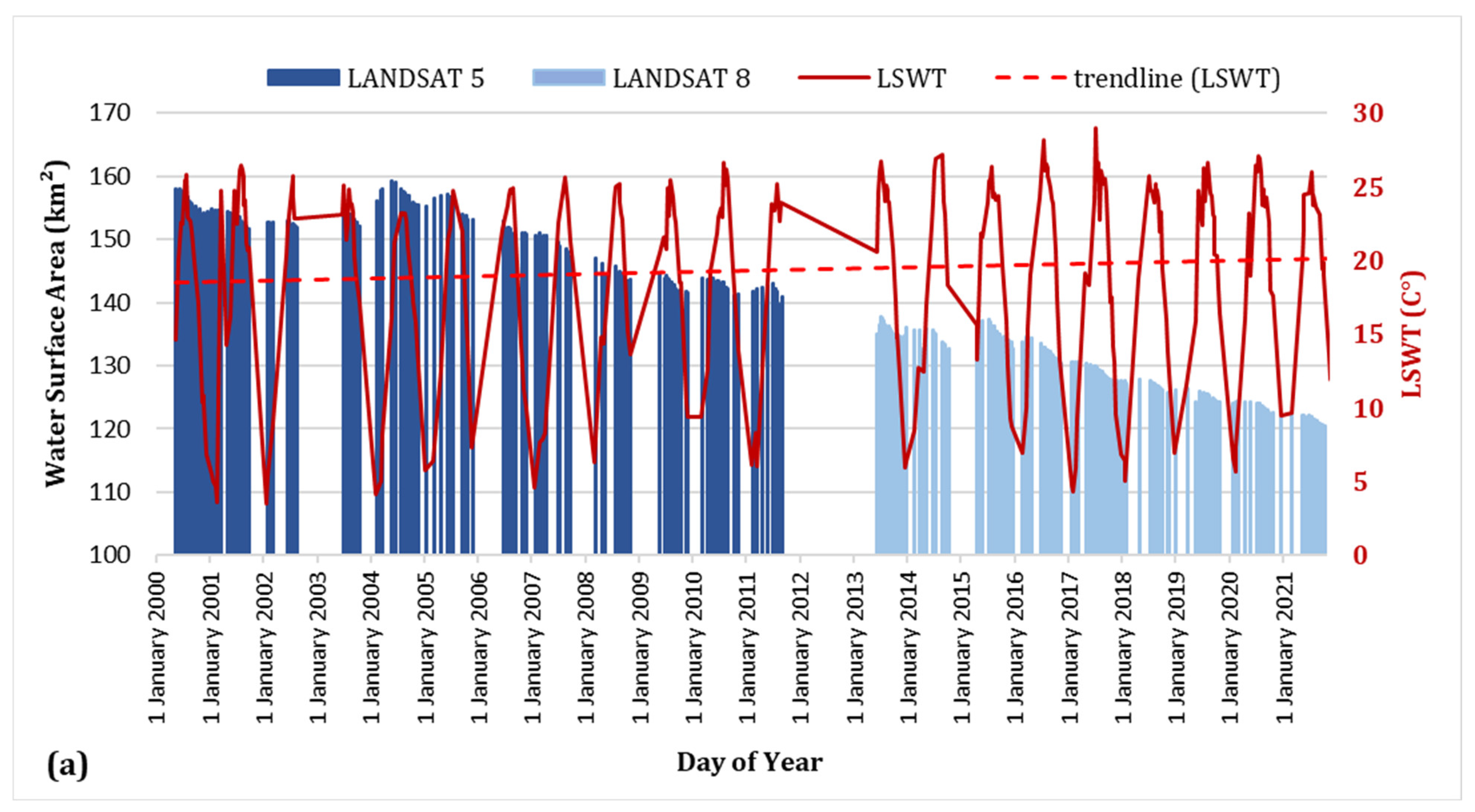
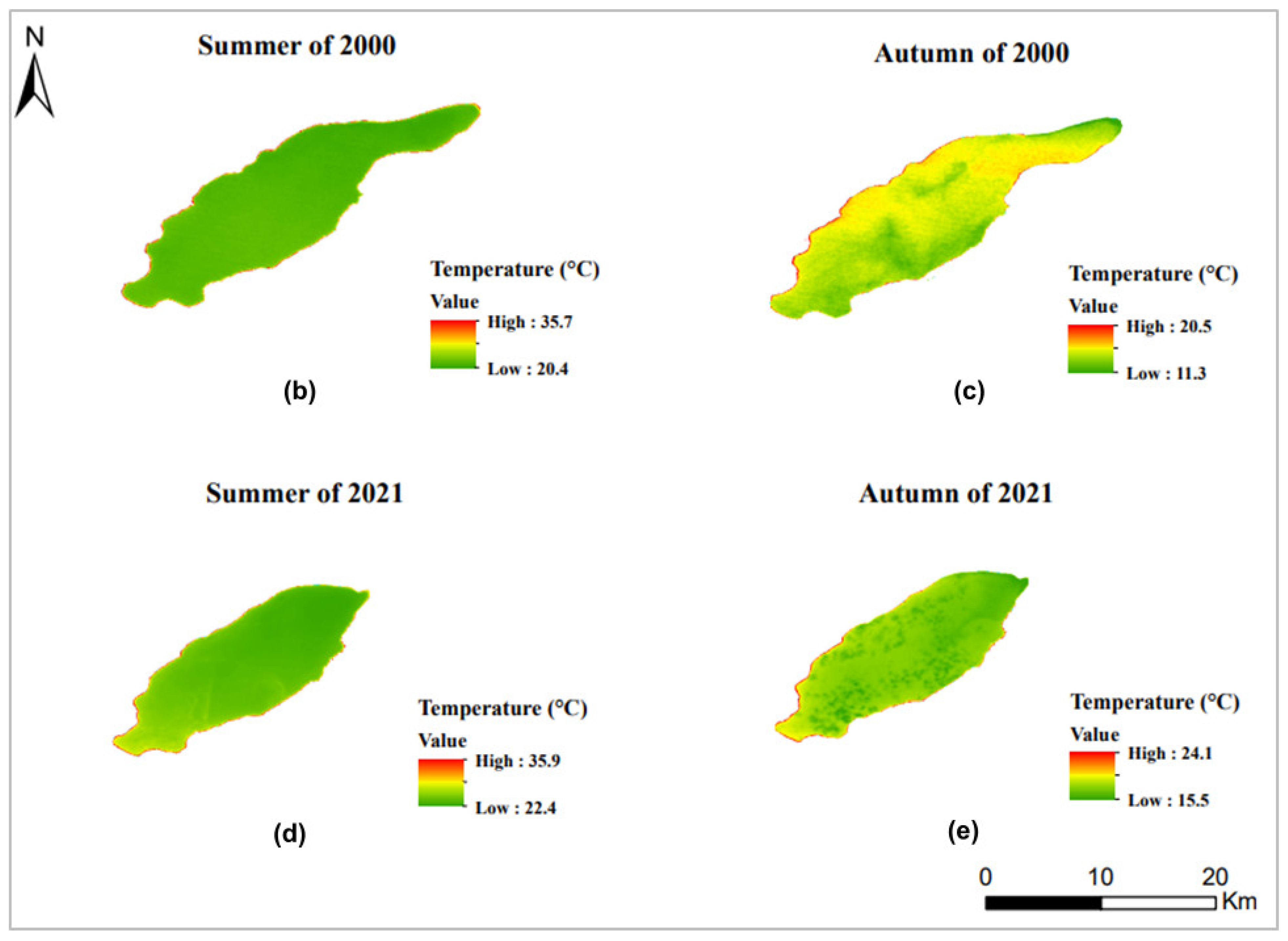
4.2.1. Lake Burdur
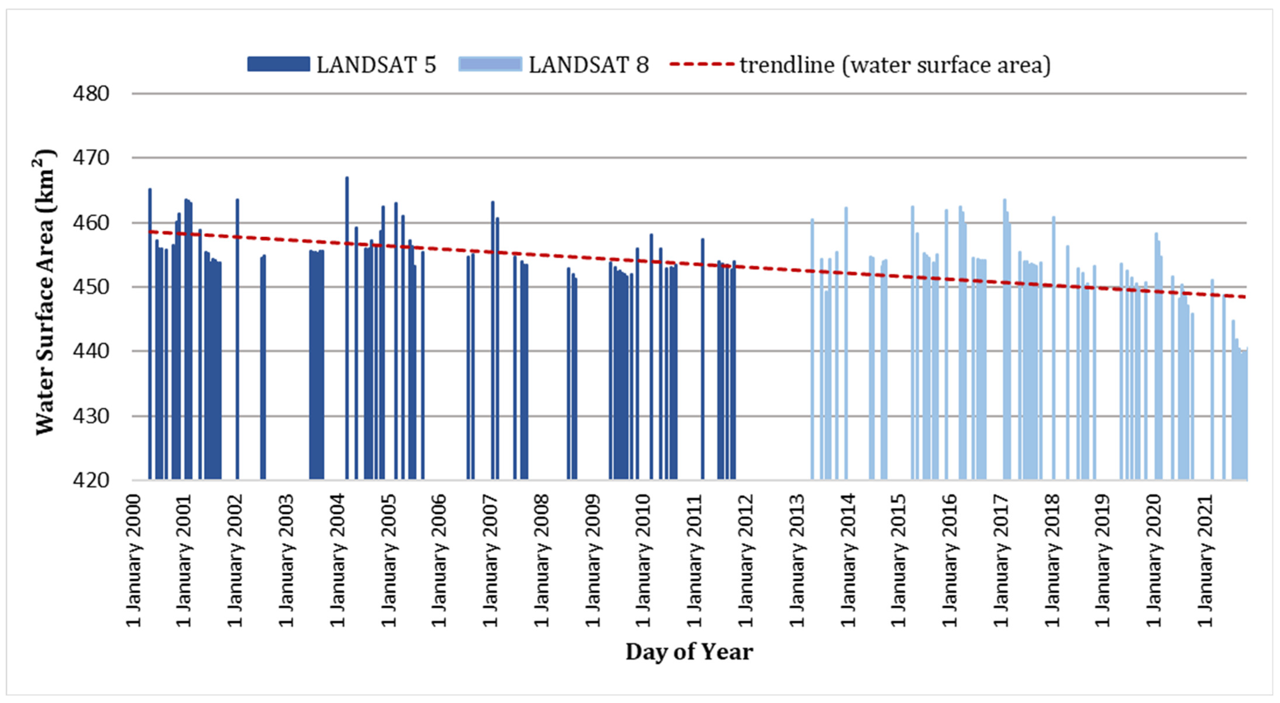
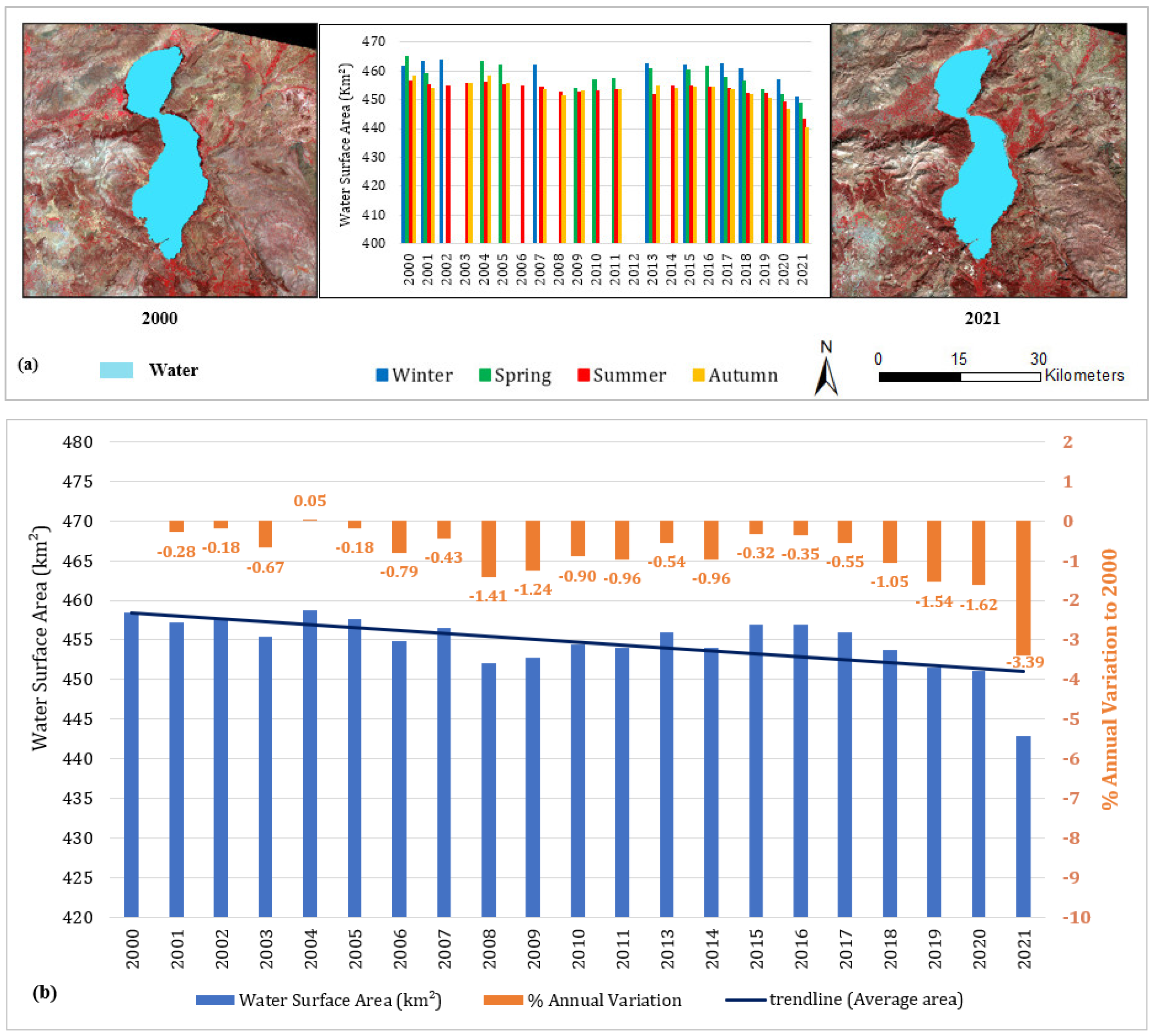
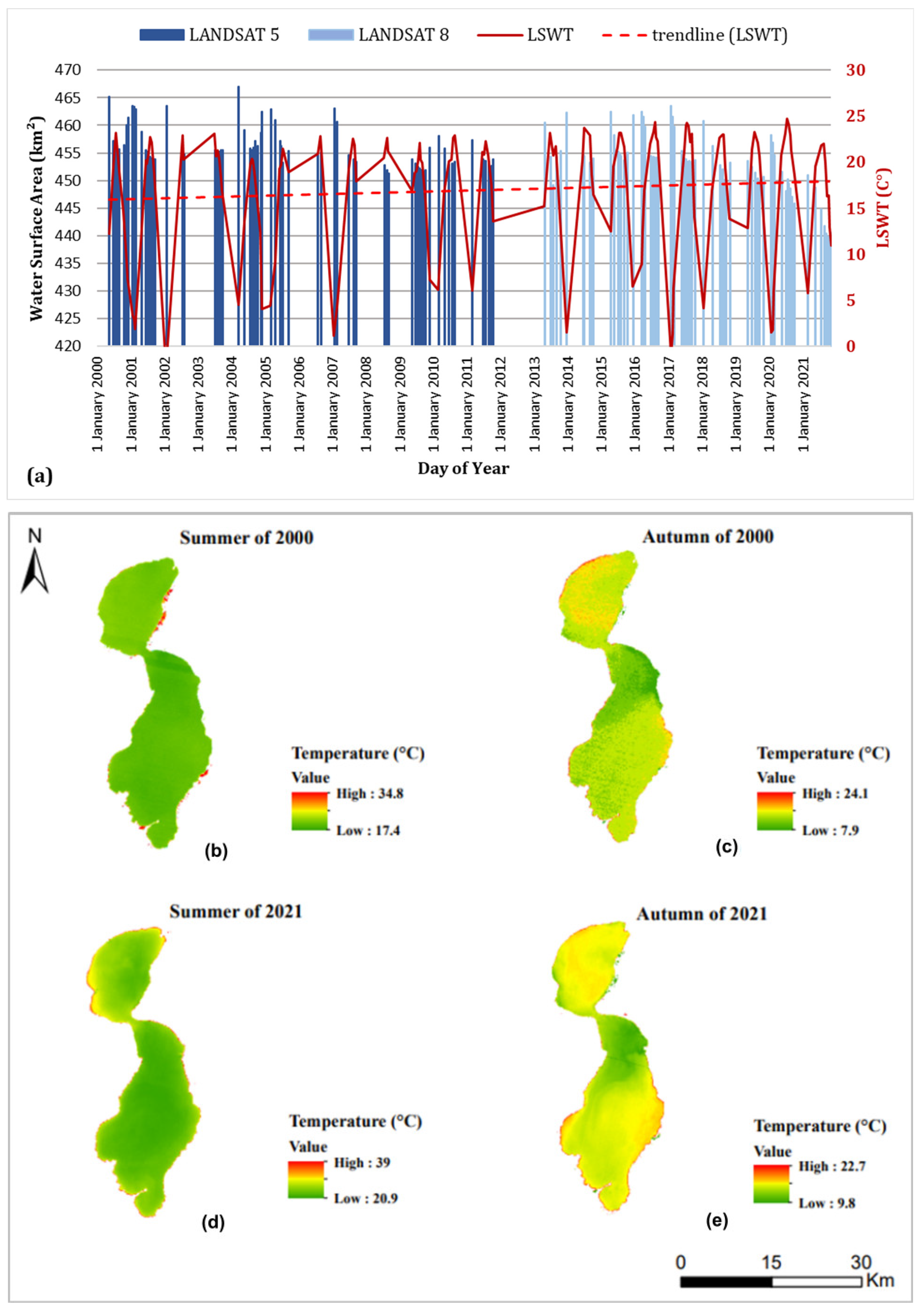
4.2.2. Lake Egirdir
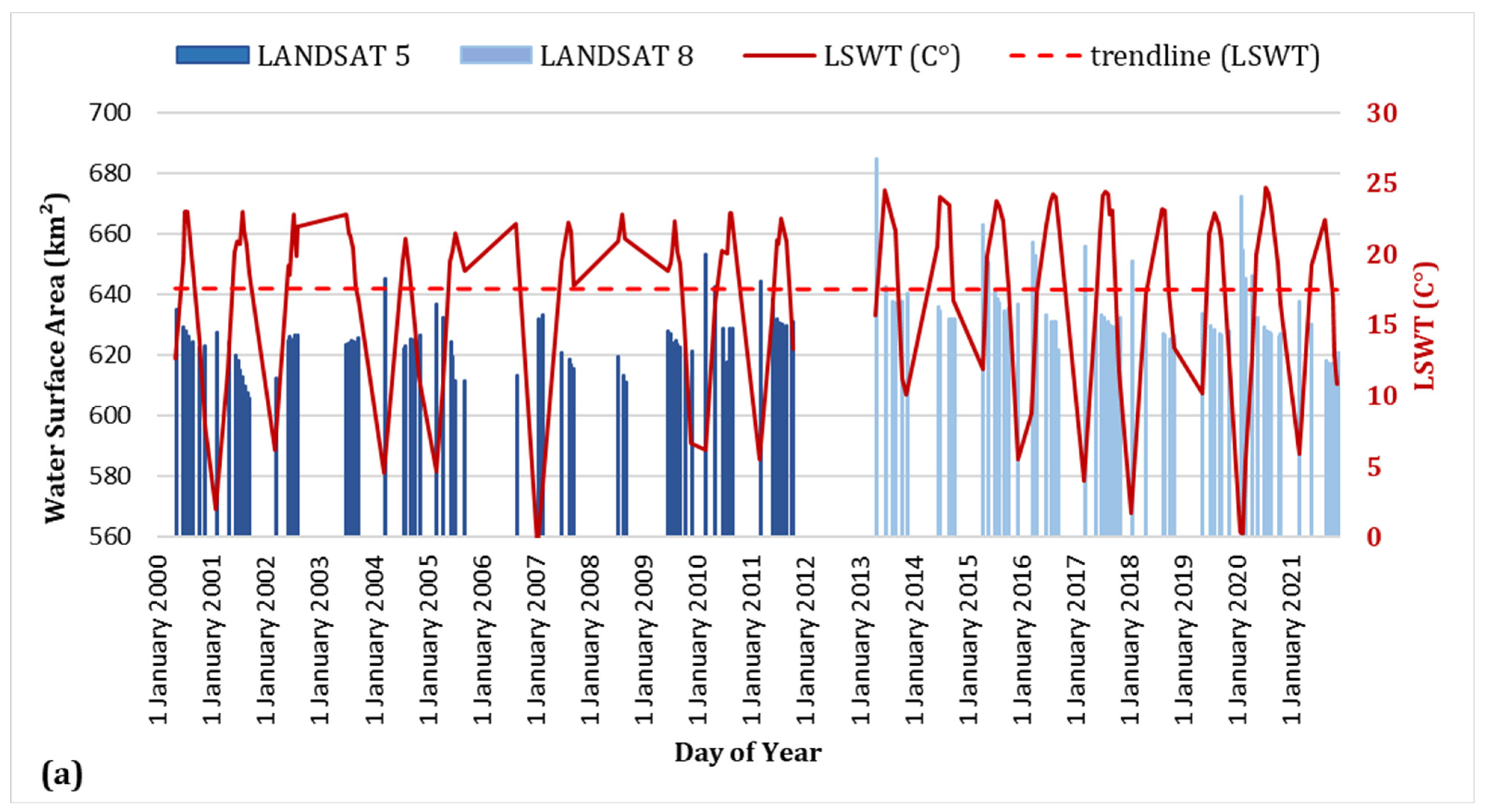
4.2.3. Lake Beysehir
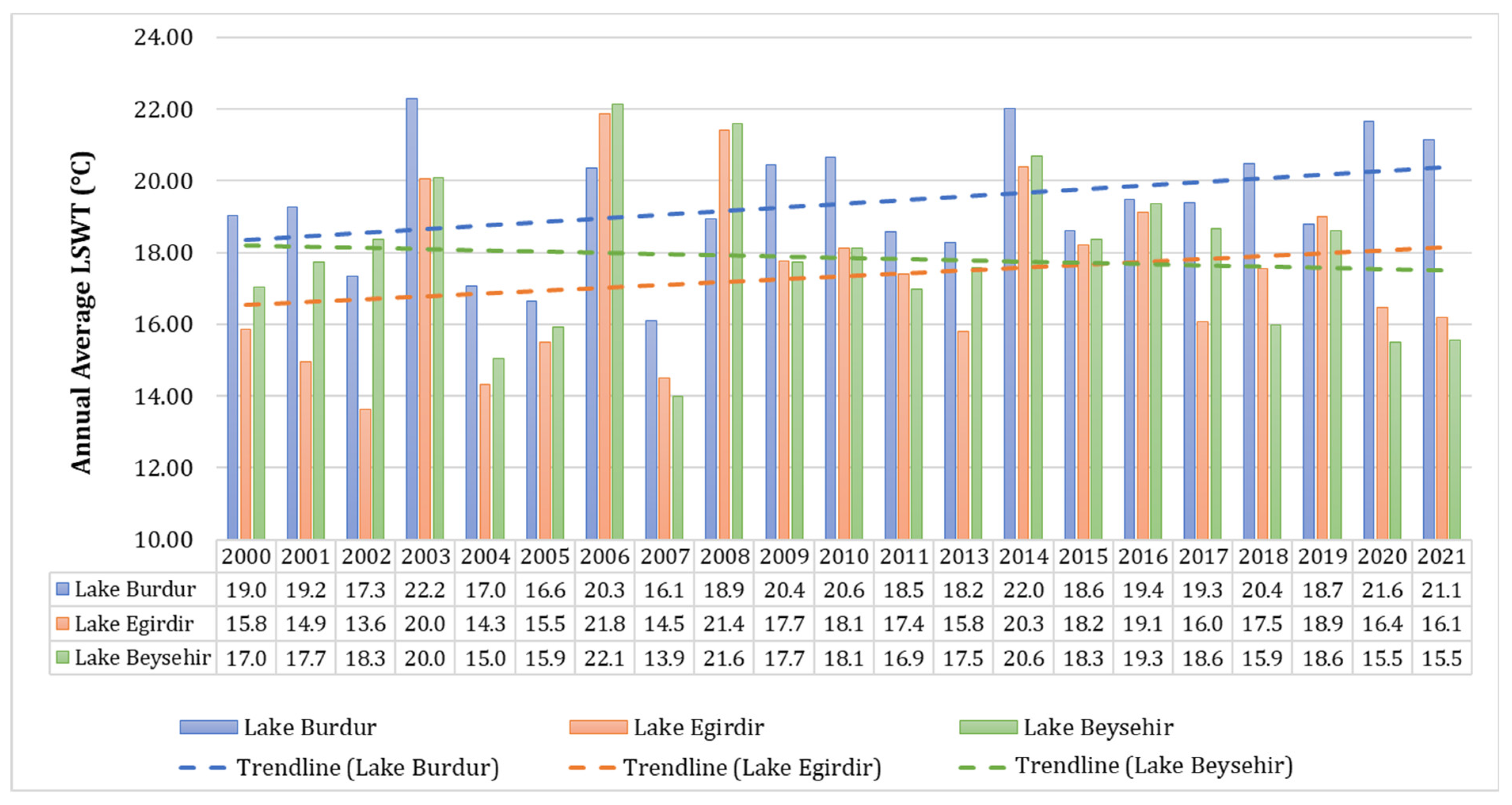
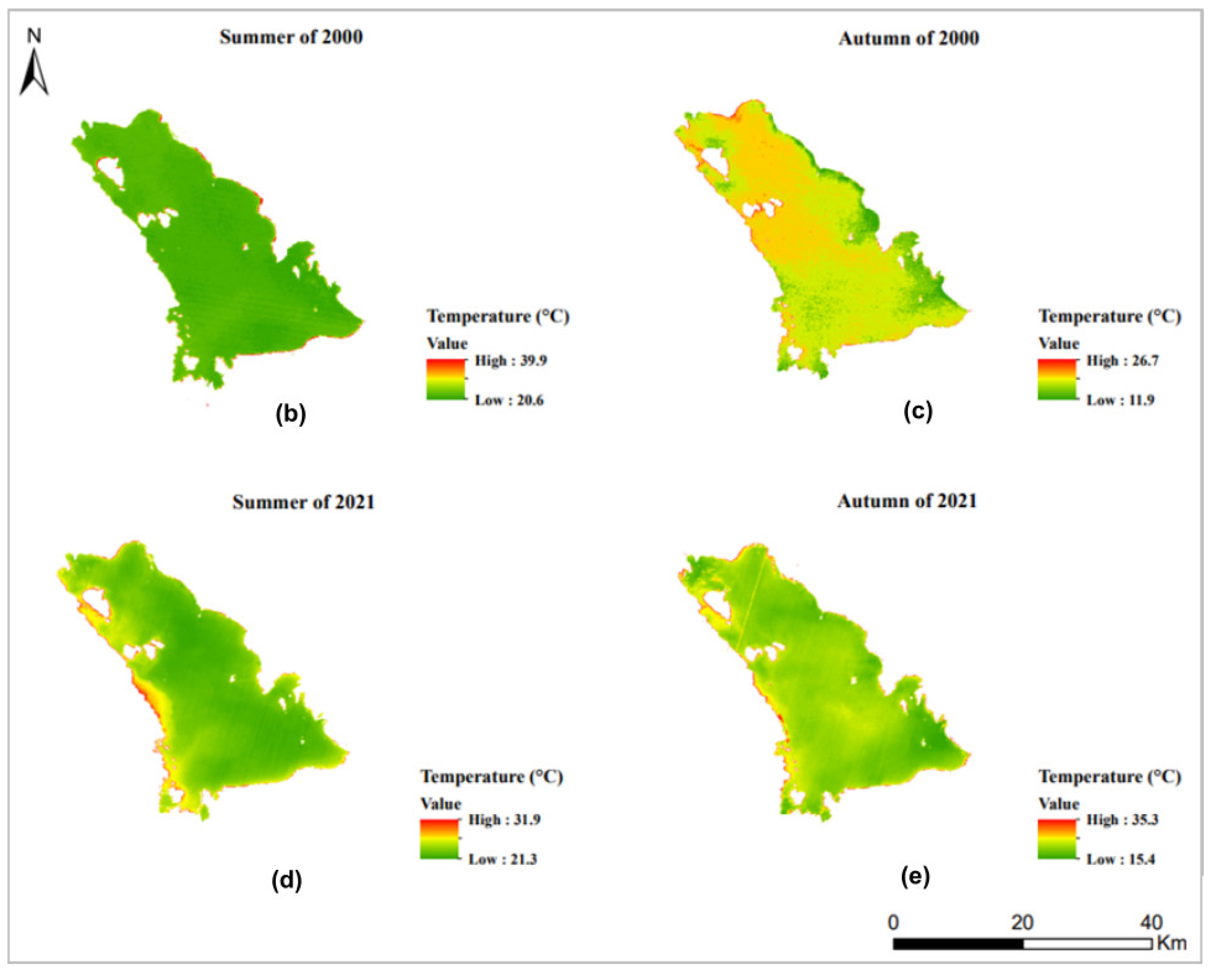
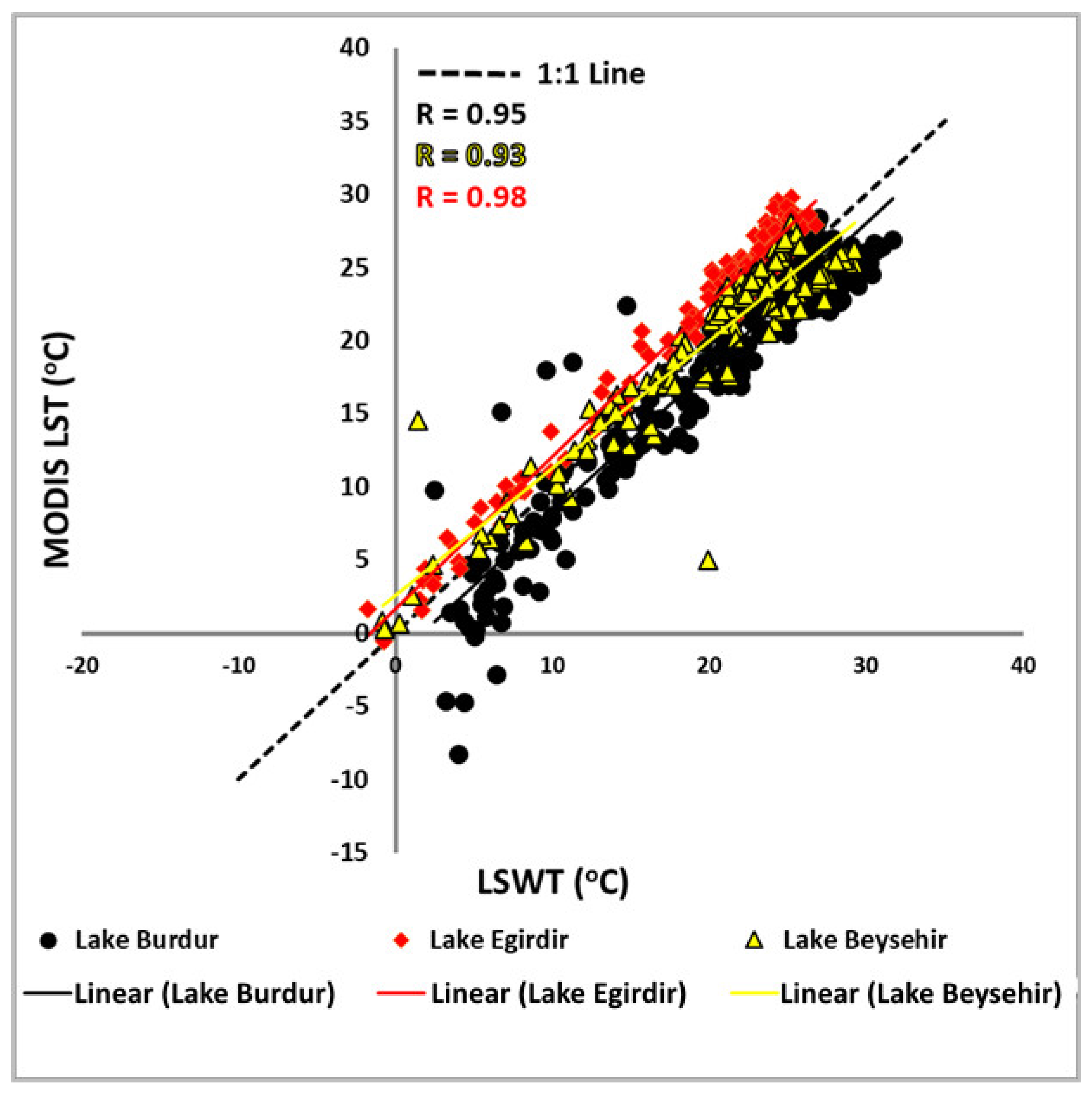
4.3. Relationship between LSWT and Lake Water Extent Changes
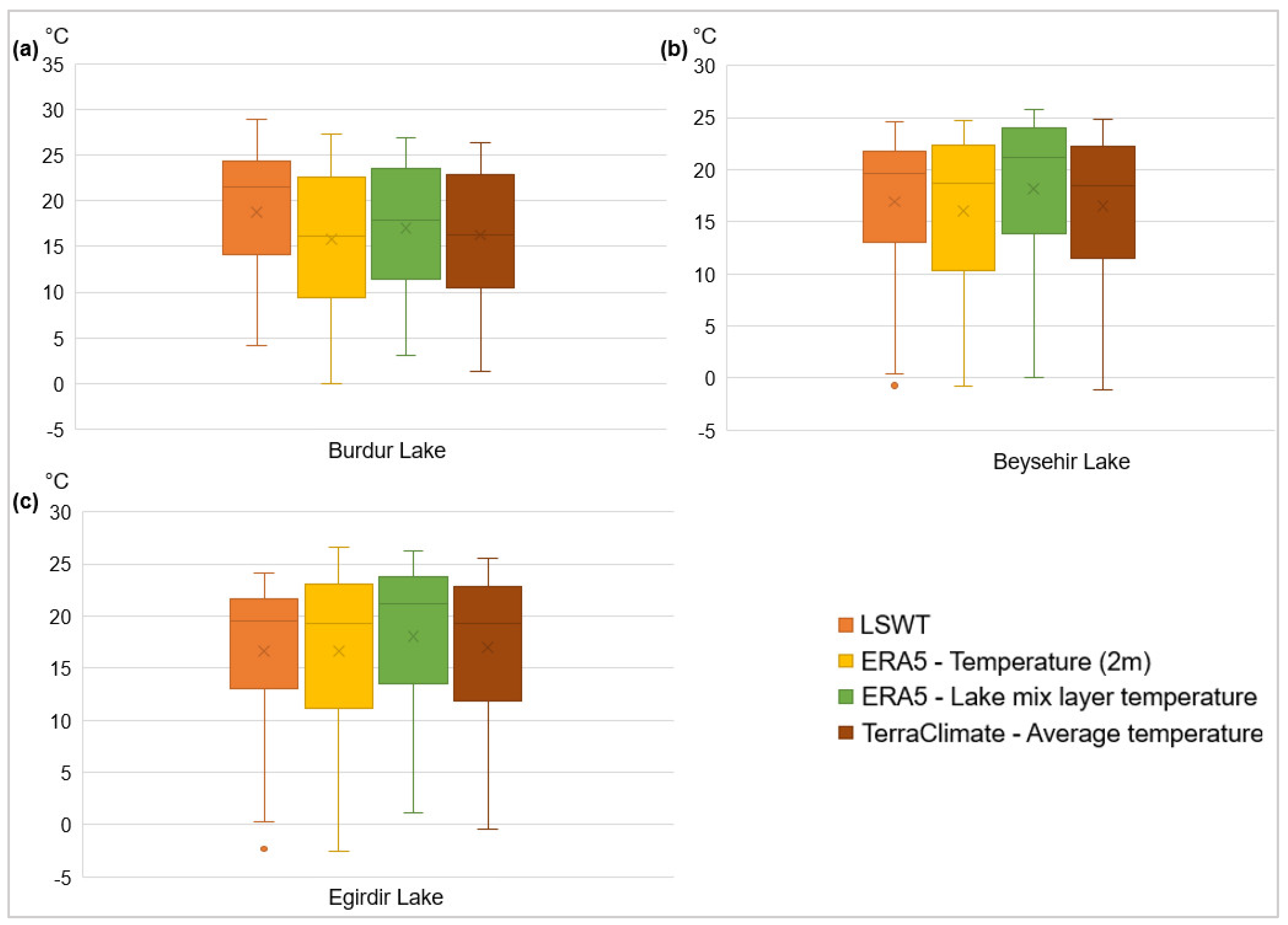
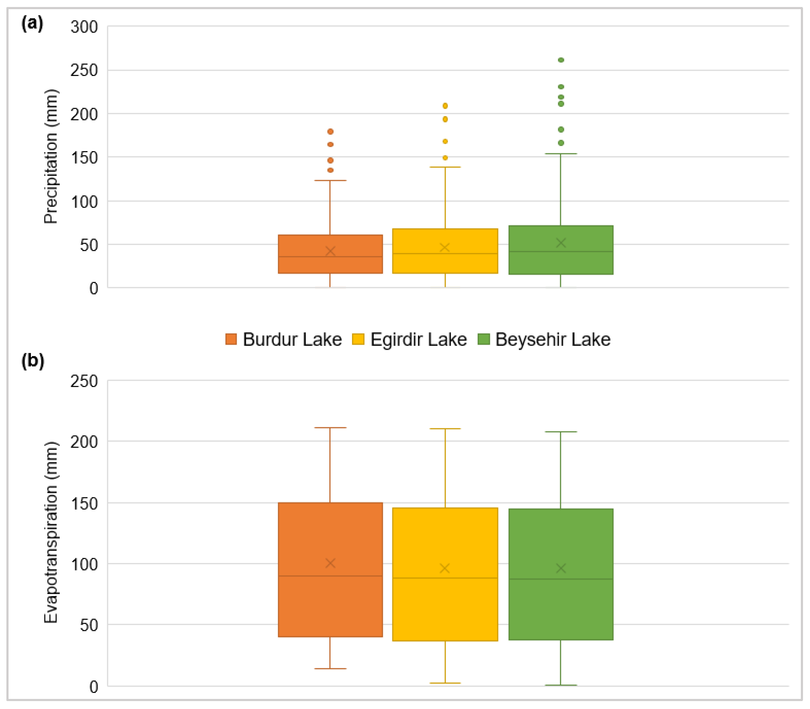
4.4. Meteorological Parameters and Correlation Analysis with LSWT and Lake Water Extent
5. Conclusions
Author Contributions
Funding
Institutional Review Board Statement
Informed Consent Statement
Data Availability Statement
Acknowledgments
Conflicts of Interest
References
- Zhang, F.; Tiyip, T.; Johnson, V.C.; Wang, J.; Nurmemet, I. Improved water extraction using Landsat TM/ETM+ images in Ebinur Lake, Xinjiang, China. Remote Sens. Appl. Soc. Environ. 2016, 4, 109–118. [Google Scholar] [CrossRef]
- Dörnhöfer, K.; Oppelt, N. Remote Sensing for lake research and monitoring—Recent advances. Ecol. Indic. 2016, 64, 105–122. [Google Scholar] [CrossRef]
- Dai, A. Increasing drought under global warming in observations and models. Nat. Clim. Chang. 2013, 3, 52–58. [Google Scholar] [CrossRef]
- Xia, H.; Zhao, J.; Qin, Y.; Yang, J.; Cui, Y.; Song, H.; Ma, L.; Jin, N.; Meng, Q. Changes in water surface area during 1989–2017 in the Huai River Basin using Landsat data and Google Earth Engine. Remote Sens. 2019, 11, 1824. [Google Scholar] [CrossRef] [Green Version]
- RCW—Ramsar Convention on Wetlands. Fact Sheet 3, Wetlands: A Global Disappearing Act. 2015. Available online: https://www.ramsar.org/sites/default/files/documents/library/factsheet3_global_disappearing_act_0.pdf (accessed on 6 April 2022).
- Ozesmi, S.L.; Bauer, M.E. Satellite remote sensing of wetlands. Wetl. Ecol. Manag. 2002, 10, 381–402. [Google Scholar] [CrossRef]
- Asokan, A.; Anitha, J. Change detection techniques for remote sensing applications: A survey. Earth Sci. Inf. 2019, 12, 143–160. [Google Scholar] [CrossRef]
- Zhou, Y.; Dong, J.; Xiao, X.; Xiao, T.; Yang, Z.; Zhao, G.; Zou, Z.; Qin, Y. Open surface water mapping algorithms: A comparison of water-related spectral indices and sensors. Water 2017, 9, 256. [Google Scholar] [CrossRef]
- Holben, B.N. Characteristics of maximum-value composite images from temporal AVHRR data. Int. J. Remote Sens. 1986, 7, 1417–1434. [Google Scholar] [CrossRef]
- Li, S.; Sun, D.; Goldberg, M.; Stefanidis, A. Derivation of 30-m-resolution water maps from TERRA/MODIS and SRTM. Remote Sens. Environ. 2013, 134, 417–430. [Google Scholar] [CrossRef]
- Feng, L.; Hou, X.; Zheng, Y. Monitoring and understanding the water transparency changes of Fifty Large Lakes on the Yangtze Plain based on long-term MODIS observations. Remote Sens. Environ. 2019, 221, 675–686. [Google Scholar] [CrossRef]
- Harvey, K.R.; Hill, G.J. Vegetation mapping of a tropical freshwater swamp in the Northern Territory, Australia: A Comparison of aerial photography, Landsat TM and SPOT satellite imagery. Int. J. Remote Sens. 2010, 1161, 2911–2925. [Google Scholar] [CrossRef]
- Li, S.; Sun, D.; Goldberg, M.D.; Sjoberg, B.; Santek, D.; Ho, J.P.; Deweese, M.; Restrepo, P.; Lindsey, S.; Holloway, E. Automatic near real-time Flood detection using Suomi-NPP/VIIRS Data. Remote Sens. Environ. 2018, 204, 672–689. [Google Scholar] [CrossRef]
- Mueller, N.; Lewis, A.; Roberts, D.; Ring, S.; Melrose, R.; Sixsmith, J.; Lymburner, L.; McIntyre, A.; Tan, P.; Curnow, S.; et al. Water observations from space: Mapping surface water from 25 years of Landsat imagery across Australia. Remote Sens. Environ. 2016, 174, 341–352. [Google Scholar] [CrossRef] [Green Version]
- Chen, B.; Chen, L.; Huang, B.; Michishita, R.; Xu, B. Dynamic monitoring of the Poyang Lake wetland by integrating Landsat and MODIS observations. ISPRS J. Photogram. Remote Sens. 2018, 139, 75–87. [Google Scholar] [CrossRef]
- Wang, X.; Xiao, X.; Zou, Z.; Chen, B.; Ma, J.; Dong, J.; Doughty, R.B.; Zhong, Q.; Qin, Y.; Dai, S.; et al. Tracking annual changes of coastal tidal flats in China during 1986–2016 through analyses of Landsat images with Google Earth Engine. Remote Sens. Environ. 2020, 238, 110987. [Google Scholar] [CrossRef]
- Du, Y.; Zhang, Y.; Ling, F.; Wang, Q.; Li, W.; Li, X. Water bodies’ mapping from Sentinel-2 imagery with modified normalized difference water index at 10-m spatial resolution produced by sharpening the SWIR band. Remote Sens. 2016, 8, 354. [Google Scholar] [CrossRef] [Green Version]
- Yang, X.; Zhao, S.; Qin, X.; Zhao, N.; Liang, L. Mapping of urban surface water bodies from Sentinel-2 MSI imagery at 10 m resolution via NDWI-based image sharpening. Remote Sens. 2017, 9, 596. [Google Scholar] [CrossRef] [Green Version]
- Feyisa, G.L.; Meilby, H.; Fensholt, R.; Proud, S.R. Automated Water Extraction Index: A new technique for surface water mapping using Landsat imagery. Remote Sens. Environ. 2014, 140, 23–35. [Google Scholar] [CrossRef]
- Wang, Y.; Ma, J.; Xiao, X.; Wang, X.; Dai, S.; Zhao, B. Long-term dynamic of Poyang Lake surface water: A mapping work based on the Google Earth Engine cloud platform. Remote Sens. 2019, 11, 313. [Google Scholar] [CrossRef] [Green Version]
- Gorelick, N.; Hancher, M.; Dixon, M.; Ilyushchenko, S.; Thau, D.; Moore, R. Google Earth Engine: Planetary-scale geospatial analysis for everyone. Remote Sens. Environ. 2017, 202, 18–27. [Google Scholar] [CrossRef]
- Buma, W.G.; Lee, S.I.; Seo, J.Y. Recent surface water extent of Lake Chad from multispectral sensors and GRACE. Sensors 2018, 18, 2082. [Google Scholar] [CrossRef] [Green Version]
- Wang, R.; Xia, H.; Qin, Y.; Niu, W.; Pan, L.; Li, R.; Zhao, X.; Bian, X.; Fu, P. Dynamic monitoring of surface water area during 1989–2019 in the Hetao Plain using Landsat data in Google Earth Engine. Water 2020, 12, 3010. [Google Scholar] [CrossRef]
- Bai, J.; Chen, X.; Li, J.; Yang, L.; Fang, H. Changes in the area of inland lakes in arid regions of central Asia during the past 30 years. Environ. Monit. Assess. 2011, 178, 247–256. [Google Scholar] [CrossRef] [PubMed]
- Soltani, K.; Amiri, A.; Zeynoddin, M.; Ebtehaj, I.; Gharabaghi, B.; Bonakdari, H. Forecasting monthly fluctuations of lake surface areas using remote sensing techniques and novel machine learning methods. Theo. Appl. Clim. 2021, 143, 713–735. [Google Scholar] [CrossRef]
- O’Reilly, C.M.; Sharma, S.; Gray, D.K.; Hampton, S.E.; Read, J.; Rowley, R.J.; Schneider, P.; Lenters, J.D.; Mcintyre, P.B.; Kraemer, B.M.; et al. Rapid and highly variable warming of lake surface waters around the globe. Geophys. Res. Lett. 2015, 42, 10773–10781. [Google Scholar] [CrossRef] [Green Version]
- Yamak, B.; Yagci, Z.; Bilgilioglu, B.B.; Comert, R. Investigation of the effect of urbanization on land surface temperature example of Bursa. Int. J. Eng. Geosci. 2021, 6, 1–8. [Google Scholar] [CrossRef]
- Xie, C.; Zhang, X.; Zhuang, L.; Zhu, R.; Guo, J. Analysis of surface temperature variation of lakes in China using MODIS land surface temperature data. Sci. Rep. 2022, 12, 2415. [Google Scholar] [CrossRef]
- WWF—World Wide Fund for Nature. Türkiye’deki Ramsar Alanları Değerlendirme Raporu. 2008. Available online: http://awsassets.wwftr.panda.org/downloads/wwf_turkiye_ramsar_alanlari_degerlendirme_raporu.pdf (accessed on 6 April 2022).
- Dervisoglu, A. Analysis of the temporal changes of inland Ramsar sites in Turkey using Google Earth Engine. ISPRS Int. J. Geo-Inf. 2021, 10, 521. [Google Scholar] [CrossRef]
- Fethi, F.; Ileri, O.; Avci, K.M.; Kocadere, M. Eğirdir ve Beyşehir göllerinin uydu verileri ve topoğrafik harita yardımıyla kıyı çizgisi değişimleri. Doğal Kaynaklar Ekon. Bülteni 2015, 20, 37–45. (In Turkish) [Google Scholar]
- Gozukara, G.; Altunbas, S.; Mustafa, S. Burdur Gölü’ndeki seviye değişimi sonucunda ortaya çıkan lakustrin materyalin zamansal ve mekansal değişimi. Anadolu Tarım Bilimleri Derg. 2019, 34, 386–396. [Google Scholar] [CrossRef] [Green Version]
- Abujayyab, S.K.; Almotairi, K.H.; Alswaitti, M.; Amr, S.S.A.; Alkarkhi, A.F.; Tasoglu, E.; Hussein, A.M. Effects of meteorological parameters on surface water loss in Burdur Lake, Turkey over 34 Years Landsat Google Earth Engine time-series. Land 2021, 10, 1301. [Google Scholar] [CrossRef]
- Aslan, N.; Koc-San, D. Investigation of the changes of lake surface temperatures and areas: Case study of Burdur and Egirdir Lakes, Turkey. Int. Arch. Photogramm. Remote Sens. Spat. Inf. Sci. 2021, 43, 299–304. [Google Scholar] [CrossRef]
- Firatli, E.; Dervisoglu, A.; Yagmur, N.; Musaoglu, N.; Tanik, A. Spatio-temporal assessment of natural lakes in Turkey. Earth Sci. Inf. 2022, 15, 951–964. [Google Scholar] [CrossRef]
- Atalay, I.; Efe, R. Ecoregions of the Mediterranean area and the lakes region of Turkey. In Proceedings of the International Symposium on Geography, Antalya, Turkey, 5–8 June 2007; pp. 3–15. [Google Scholar]
- Turkish State Meteorological Service. Areal Precipitation Report. 2021. Available online: https://www.mgm.gov.tr/veridegerlendirme/yagis-raporu.aspx (accessed on 5 May 2022).
- Ministry of Agriculture and Forestry (MoAF). General Directorate of Nature Conservation and National Parks. Available online: https://saybis.tarimorman.gov.tr/# (accessed on 6 April 2022).
- Google Earth Engine. Available online: https://earthengine.google.com/ (accessed on 7 April 2022).
- NASA. Available online: https://landsat.gsfc.nasa.gov/about/technical-information/ (accessed on 7 April 2022).
- Sarp, G.; Ozcelik, M. Water body extraction and change detection using time series: A case study of Lake Burdur, Turkey. J. Taibah Univ. Sci. 2017, 11, 381–391. [Google Scholar] [CrossRef] [Green Version]
- EPA. Available online: https://19january2017snapshot.epa.gov/climate-impacts/climate-impacts-water-resources_.html (accessed on 5 May 2022).
- Gorguner, M.; Kavvas, M.L. Modeling impacts of future climate change on reservoir storages and irrigation water demands in a Mediterranean basin. Sci. Total Environ. 2020, 748, 141246. [Google Scholar] [CrossRef]
- ERA5-Land. Available online: https://cds.climate.copernicus.eu/cdsapp#!/dataset/reanalysis-era5-land-monthly-means?tab=overview (accessed on 6 May 2022).
- TerraClimate. Available online: https://www.climatologylab.org/terraclimate.html (accessed on 6 May 2022).
- Li, W.; Du, Z.; Ling, F.; Zhou, D.; Wang, H.; Gui, Y.; Sun, B.; Zhang, X. A comparison of land surface water mapping using the normalized difference water index from TM, ETM+ and ALI. Remote Sens. 2013, 5, 5530–5549. [Google Scholar] [CrossRef] [Green Version]
- McFeeters, S.K. The Use of the Normalized Difference Water Index (NDWI) in the delineation of open water features. Int. J. Remote Sens. 1996, 17, 1425–1432. [Google Scholar] [CrossRef]
- Xu, H. Modification of normalised difference water index (NDWI) to enhance open water features in remotely sensed imagery. Int. J. Remote Sens. 2006, 27, 3025–3033. [Google Scholar] [CrossRef]
- Ceyhan, E. Multi-Temporal Water Extent Analysis of a Hypersaline Playa Lake Using Landsat Imagery. Master’s Thesis, Institute of Science and Technology, Middle East Technical University (METU), Ankara, Turkey, 2016. Available online: https://open.metu.edu.tr/handle/11511/25749 (accessed on 6 April 2022).
- Ozelkan, E. Water body detection analysis using NDWI indices derived from Landsat-8 OLI. Pol. J. Environ. Stud. 2020, 29, 1759–1769. [Google Scholar] [CrossRef]
- Acharya, T.D.; Subedi, A.; Lee, D.H. Evaluation of water indices for surface water extraction in a Landsat 8 scene of Nepal. Sensors 2018, 18, 2580. [Google Scholar] [CrossRef] [Green Version]
- Stehman, S.V. Estimating area and map accuracy for stratified random sampling when the strata are different from the map classes. Int. J. Remote Sen. 2014, 35, 4923–4939. [Google Scholar] [CrossRef]
- McHugh, M.L. Lessons in biostatistics interrater reliability: The Kappa statistic. Biochem. Med. 2012, 22, 276–282. [Google Scholar] [CrossRef]
- Isaya Ndossi, M.; Avdan, U. Application of open source coding technologies in the production of land surface temperature (LST) maps from Landsat: A PyQGIS plugin. Remote Sens. 2016, 8, 413. [Google Scholar] [CrossRef] [Green Version]
- Sekertekin, A.; Bonafoni, S. Sensitivity analysis and validation of daytime and nighttime land surface temperature retrievals from Landsat 8 using different algorithms and emissivity models. Remote Sens. 2020, 12, 2776. [Google Scholar] [CrossRef]
- USGS—United States Geological Survey. Using the USGS Landsat Level-1 Data Product. 2019. Available online: https://www.usgs.gov/landsat-missions/using-usgs-landsat-level-1-data-product (accessed on 6 April 2022).
- Valor, E.; Caselles, V. Mapping land surface emissivity from NDVI: Application to European, African, and South American areas. Remote Sens. Environ. 1996, 57, 167–184. [Google Scholar] [CrossRef]
- Weng, Q.; Lu, D.; Schubring, J. Estimation of land surface temperature–vegetation abundance relationship for urban heat island studies. Remote Sens. Environ. 2004, 89, 467–483. [Google Scholar] [CrossRef]
- Sobrino, J.A.; Jiménez-Muñoz, J.C.; Sòria, G.; Romaguera, M.; Guanter, L.; Moreno, J.; Plaza, A.; Martínez, P. Land surface emissivity retrieval from different VNIR and TIR sensors. IEEE Trans. Geosci. Remote Sens. 2008, 46, 316–327. [Google Scholar] [CrossRef]
- Sobrino, J.A.; Jiménez-Muñoz, J.C.; Paolini, L. Land surface temperature retrieval from Landsat TM 5. Remote Sens. Environ. 2004, 90, 434–440. [Google Scholar] [CrossRef]
- Vlassova, L.; Perez-Cabello, F.; Nieto, H.; Martín, P.; Riaño, D.; De La Riva, J. Assessment of methods for land surface temperature retrieval from Landsat-5 TM images applicable to multiscale tree-grass ecosystem modeling. Remote Sens. 2014, 6, 4345–4368. [Google Scholar] [CrossRef] [Green Version]
- Carlson, T.N.; Ripley, D.A. On the relation between NDVI, fractional vegetation cover, and leaf area index. Remote Sens. Environ. 1997, 62, 241–252. [Google Scholar] [CrossRef]
- MoAF—Ministry of Agriculture and Forestry. Burdur Lake Management Plan. 2018. Available online: https://www.tarimorman.gov.tr/Konular/Plan-Program-Ve-Faaliyet-Raporlari?Ziyaretci=Orman (accessed on 6 April 2022).
- Dervisoglu, A.; Yagmur, N.; Firatli, E.; Musaoglu, N.; Tanik, A. Spatio-temporal assessment of the shrinking Lake Burdur, Turkey. Int. J. Environ. Geoinf. 2022, 9, 169–176. [Google Scholar] [CrossRef]
| Lake | Maximum Extent (km2) | Type | Maximum Depth (m) | Elevation (m) | Purpose of Use | Protection Status |
|---|---|---|---|---|---|---|
| Burdur | 195.37 | Brackish | 100 | 857 | - | Ramsar Site |
| Egirdir | 476.92 | Freshwater | 15 | 917 | Irrigation | Natural Protected Area Drinking Water Reservoir |
| Beysehir | 706.46 | Freshwater | 15 | 1124 | Drinking water, Irrigation | Natural Park Wetland Protected Area Drinking Water Reservoir |
| NDVI Threshold | Land Cover Type | Surface Emissivity |
|---|---|---|
| NDVI < 0 | Water | 0.985 |
| 0 ≤ NDVI ≤ 0.1 | Bare Soil | (red reflectance band) |
| 0.1 ≤ NDVI ≤ 07 | Vegetation Mixed with Soil | 0.990 × Pv + 0.984 × (1 − Pv) + 0.04 × Pv × (1 − Pv) |
| NDVI > 0.7 | Vegetation | 0.990 |
| Burdur Lake 10 October 2021 Landsat 8 | Burdur Lake 20 May 2004 Landsat 5 | Egirdir Lake 10 October 2021 Landsat 8 | Egirdir Lake 17 March 2004 Landsat 5 | Beysehir Lake 17 September 2001 Landsat 5 | Beysehir Lake 27 April 2013 Landsat 8 | |
|---|---|---|---|---|---|---|
| Smallest Area | Largest Area | Smallest Area | Largest Area | Smallest Area | Largest Area | |
| Area (km2) | 120.53 | 159.29 | 439.85 | 467.00 | 605.89 | 685.01 |
| User Acc. (Water) | 99% | 99.1% | 98.3% | 98% | 100% | 97.7% |
| Producer Acc. (Water) | 100% | 100% | 100% | 100% | 99% | 100% |
| Overall Acc. | 99.3% | 99.45% | 98.7% | 98.5% | 99.3% | 98.7% |
| Kappa | 0.983 | 0.988 | 0.959 | 0.963 | 0.984 | 0.973 |
| Landsat | ERA5-Land | Terraclimate | |||||||
|---|---|---|---|---|---|---|---|---|---|
| Lake | Monthly Correlation | LSWT | Temperature (2 m) | Lake mix layer temperature (C°) | Total evaporation (m) | Precipitation (mm) | Total Precipitation (mm) | Evapotranspiration (mm) | Average Temp |
| Burdur | Water surface area | −0.207 ** | 0.018 | 0.012 | −0.086 | −0.107 | −0.061 | 0.095 | 0.028 |
| LSWT | 0.507 ** | 0.478 ** | −0.567 ** | −0.224 ** | −0.194 ** | 0.576 ** | 0.524 ** | ||
| Beysehir | Water surface area | −0.418 ** | −0.602 ** | −0.584 ** | 0.529 ** | 0.487 ** | 0.430 ** | −0.332 ** | −0.480 ** |
| LSWT | 0.806 ** | 0.858 ** | −0.929 ** | −0.349 ** | −0.651 ** | 0.857 ** | 0.944 ** | ||
| Egirdir | Water surface area | −0.768 ** | −0.729 ** | −0.734 ** | 0.554 ** | 0.386 ** | 0.346 ** | −0.564 ** | −0.716 ** |
| LSWT | 0.964 ** | 0.972 ** | −0.872 ** | −0.599 ** | −0.530 ** | 0.872 ** | 0.960 ** | ||
| very high | high | moderate | low | very low | |||||
| ** Correlation is significant at the 0.01 level (2-tailed). | |||||||||
Publisher’s Note: MDPI stays neutral with regard to jurisdictional claims in published maps and institutional affiliations. |
© 2022 by the authors. Licensee MDPI, Basel, Switzerland. This article is an open access article distributed under the terms and conditions of the Creative Commons Attribution (CC BY) license (https://creativecommons.org/licenses/by/4.0/).
Share and Cite
Albarqouni, M.M.Y.; Yagmur, N.; Bektas Balcik, F.; Sekertekin, A. Assessment of Spatio-Temporal Changes in Water Surface Extents and Lake Surface Temperatures Using Google Earth Engine for Lakes Region, Türkiye. ISPRS Int. J. Geo-Inf. 2022, 11, 407. https://doi.org/10.3390/ijgi11070407
Albarqouni MMY, Yagmur N, Bektas Balcik F, Sekertekin A. Assessment of Spatio-Temporal Changes in Water Surface Extents and Lake Surface Temperatures Using Google Earth Engine for Lakes Region, Türkiye. ISPRS International Journal of Geo-Information. 2022; 11(7):407. https://doi.org/10.3390/ijgi11070407
Chicago/Turabian StyleAlbarqouni, Mohammed M. Y., Nur Yagmur, Filiz Bektas Balcik, and Aliihsan Sekertekin. 2022. "Assessment of Spatio-Temporal Changes in Water Surface Extents and Lake Surface Temperatures Using Google Earth Engine for Lakes Region, Türkiye" ISPRS International Journal of Geo-Information 11, no. 7: 407. https://doi.org/10.3390/ijgi11070407
APA StyleAlbarqouni, M. M. Y., Yagmur, N., Bektas Balcik, F., & Sekertekin, A. (2022). Assessment of Spatio-Temporal Changes in Water Surface Extents and Lake Surface Temperatures Using Google Earth Engine for Lakes Region, Türkiye. ISPRS International Journal of Geo-Information, 11(7), 407. https://doi.org/10.3390/ijgi11070407