


Abstract
Availability and applications of open-source data for disaster risk reductions are increasing. Flood hazards are a constant threat to local communities and infrastructures (e.g., built-up environment and agricultural areas) in Nepal. Due to its negative consequences on societies and economic aspects, it is critical to monitor and map those risks. This study presents the open access earth observation (EO) data, geospatial products, and different analytical models available for flood risk assessment (FRA) and monitoring in Nepal. The status of flood risk knowledge and open-source data was reviewed through a systematic literature review. Multispectral optical data are widely used, but use of microwave data is extremely low. With the recent developments in this field, especially optical and microwave data, the monitoring, mapping, and modeling of flood hazards and risk have been more rapid and precise and are published in several scientific articles. This study shows that the choice of appropriate measurements and data for a flood risk assessment and management involves an understanding of the flood risk mechanism, flood plain dynamics, and primary parameter that should be addressed in order to minimize the risk. At the catchments, floodplains, and basin level, a variety of open data sources and models may be used under different socioeconomic and environmental limitations. If combined and analyzed further, multi-source data from different models and platforms could produce a new result to better understand the risks and mitigation measures related to various disasters. The finding of this study helps to select and apply appropriate data and models for flood risk assessment and management in the countries like Nepal where the proprietary data and models are not easily accessible.
1. Introduction
Evidence-based decision-making on flood hazards and risk management is possible through factual data and detailed assessment [1,2,3]. The lack of adequate data affects the ability to model, predict, and plan for hazards and risk, which can have obvious negative consequences on human health and socio-economic aspects [4,5]. Natural phenomena become hazards when they have the potential of inflicting damage on people’s lives along with causing economic and social losses [6,7]. All such disasters are challenging to eliminate, but with advancements in science and technology, the hazards’ frequency and intensity can be estimated [5,8,9]. These estimations are backed by data and scientific evidence, which can significantly help alleviate the negative consequences of employing effective risk assessment measures [10,11,12]. The nature and extent of any risk can be determined by evaluating the existing vulnerability conditions that could potentially harm the people at risk, their livelihoods, and the environment [13,14].
Nepal is highly prone to various natural disasters due to its diverse and rugged topography coupled with active tectonic plates [15]. The country’s typical north-south extension is about 140 km, while its east-west extent is around 800 km, nearly parallel to the Himalayan axis. The elevation varies across this short span from 60 m in Terai to 8848.5 m in the High Himalaya, with five separate physiographic zones (Terai, Siwalik, Middle Mountain, High Mountain, and High Himalaya). It is highly flood-prone (mainly Terai) and ranks 20th worldwide in terms of flood-affected populations. For example, in August 2017, floods triggered by heavy rainfall affected up to 1.7 million people across 35 of 75 districts of Nepal [16]. The flooding and inundation displaced approximately 461,000 people and destroyed 65,000 houses. In 2012, 40 people were killed and 32 went missing when water surged down the Seti River due to a landslide [15]. In addition to the natural factors, Nepal’s disaster-induced damages increase due to human activities, such as deforestation, unplanned settlements, and inadequate proactive legislation. Common types of floods in Nepal includes fluvial/inland, flash floods, dam burst floods, and urban floods.
Data deficiencies on disaster risk assessment and planning leads to a massive loss of human lives and economic assets [17,18,19]. The Government of Nepal has been trying its best to strengthen the institutional setup and improve the data system, data availability, and accessibility in its federal structure [20]. A responsible national authority has recently been established to look after overall Disaster Risk Reduction (DRR) measures and management-related issues in Nepal [21]. At provincial and local levels, disaster management committees are responsible for working on these issues. Moreover, these authorities are mandated to continuously work in a complete disaster management cycle to prepare and act in case of any natural disaster; however, these authorities are having difficulty making proper decisions due to the constant lack of evidence and reliable data.
Many studies are available in Nepal on the study of floods using high-resolution remote sensing imagery, Google Earth, and Digital Elevation Model (DEM) to identify the flood susceptible area. For this, hydraulic and hydrological modelling are commonly used approaches. Sharma and others [22] summarized the basin-wide flood hazard studies in Nepal and discussed the remote sensing approaches. Further, they indicated that both the commercial and open data are used but did not extensively consider the potential and extent of the open data and analytical tools.
Open data are unrestricted, freely available data that anyone can access, use, and redistribute, and exist in digital, machine-readable format [23,24]. Such data are accessed by users usually through web-based interfaces called open data portals. For example, (a) USGS provides open access earth observation mission products such as Landsat, Sentinel, and DEMs from different sources; (b) web-portal hosted by the government and international organizations provides disaster incident and magnitude data; and (c) open-source analytical models and tools such as HECRAS, GIS, Integrated Flood Analysis System (IFAS), and machine learning algorithms facilitate the assessment and management of flood risk. The demand for open data is increasing rapidly in developing countries, such as Nepal, where there is a critical knowledge gap regarding the use, potential and challenges associated with the use of data [25]. Open data helps increase data accessibility, enhances community involvement, promotes transparency of research results, increases effectiveness, decreases costs of data, and promotes advancement and innovation [26]. The use of these available data could provide an efficient, cost-effective, and timely assessment of the risk and support in taking preparedness actions. Analytical models are mathematical models with a closed form solution, meaning that a mathematical analytic function may be utilized to define the solution to the equations used to describe changes in a system. Using such models, the mechanisms underlying complex physical processes can be simulated, elucidated, and predictions can be made. These models have been used mainly for predicting system behavior and understanding various hydrological and hydrodynamics processes in terms of assessing floods and landslides.
Studies that examine flood risk analysis and assessment evaluations often focus on methodological and scale-related difficulties, uncertainty, mapping, or economic damage issues; however, the majority of these studies offer a glimpse of the scientific state of the art for risk assessment that is just a partial overview, centered on a small proportion of chosen data sources and methodologies. A comprehensive literature analysis to assess the application of data and models for flood risk assessment and management is lacking in Nepal.
This study aims to exploit recent advances in Earth Observation (EO), open-source data from various sources, and high-performance analytical models to innovate an approach for flood risk and impact assessment through a systematic literature review and analysis. This study also aims at setting a recommendation to develop a risk assessment platform that could be significantly helpful for the Disaster Risk Assessment (DRA) and preparedness strategies at the local government units in Nepal.
2. Materials and Methods
2.1. Data Collection
The existing literature was reviewed for the available open data sources, analytical models, and computational resources including an open-source web-based risk assessment platform, which can be potentially used for flood hazards and risk mapping and assessment, and modelling. The data and information available at different spatial scales (global, regional, federal, and local) were considered for the review with a specific focus on the Nepalese context.
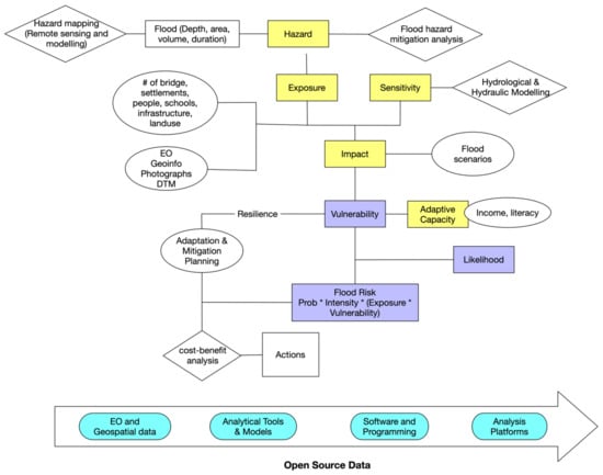
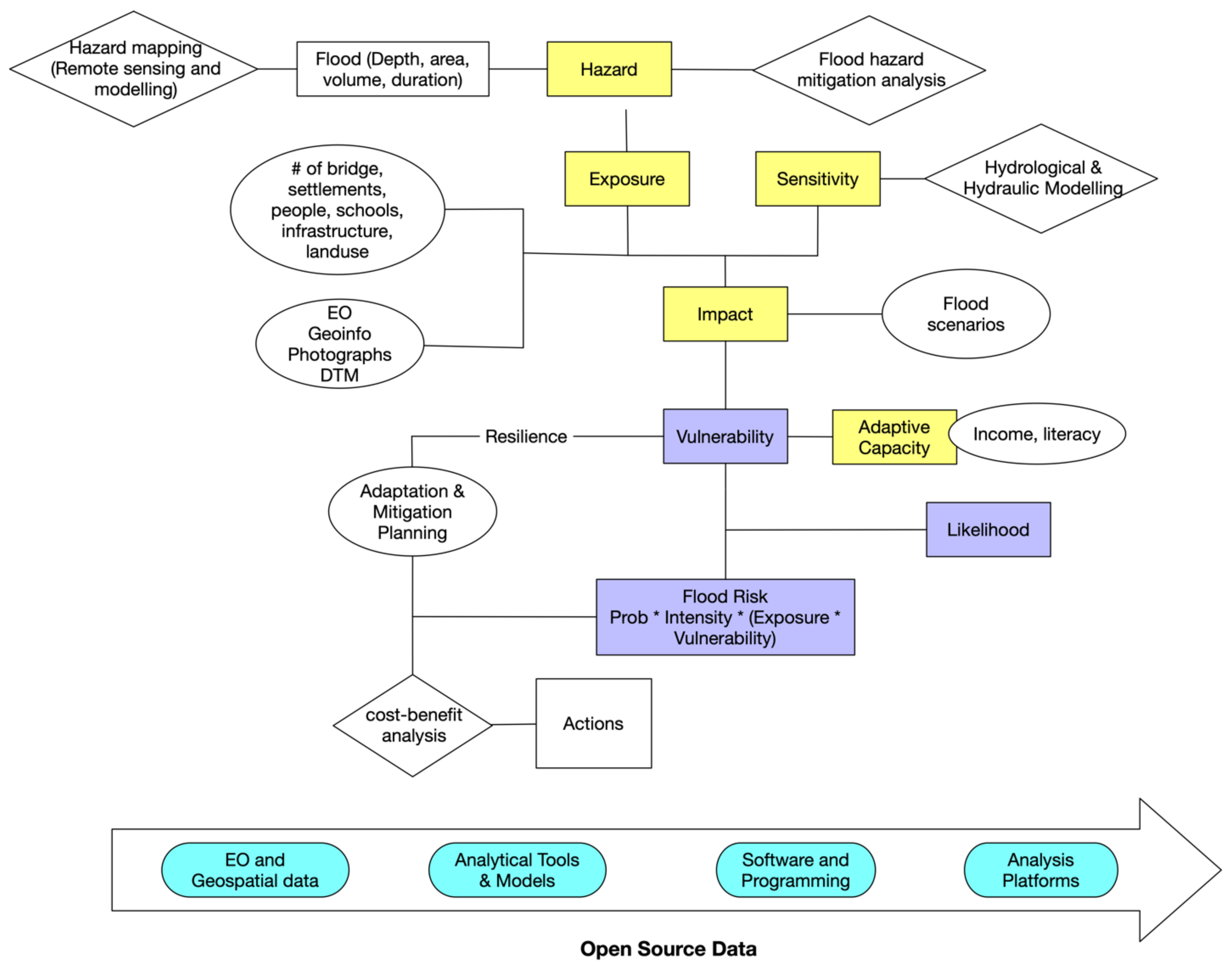
A systematic literature review [27,28,29] was used following the PRISMA Protocol [30] for this study. In this process, the review was completed in two phases. The first phase includes: (a) definition of the scope of the analysis to draw the boundary of the study; (b) locating studies by keywords, time, type of documents, and language; and (c) selection and evaluation of relevant papers. The second phase constitutes the extraction and presentation of relevant information from the screened and selected studies in the first phase. The conceptual framework of the study is presented in Figure 1. As shown in Figure 1, vulnerability to flood hazard is the function of exposure to hazards, sensitivity, and adaptive capacity. Whether it be identifying risk and vulnerabilities or planning for resilience, all require hazard mapping and modeling. Open data alternatives and models would help to perform such tasks with greater efficiency and transparency.
Figure 1.
Flood risk assessment methods and conceptual framework of the study.
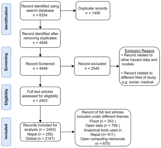
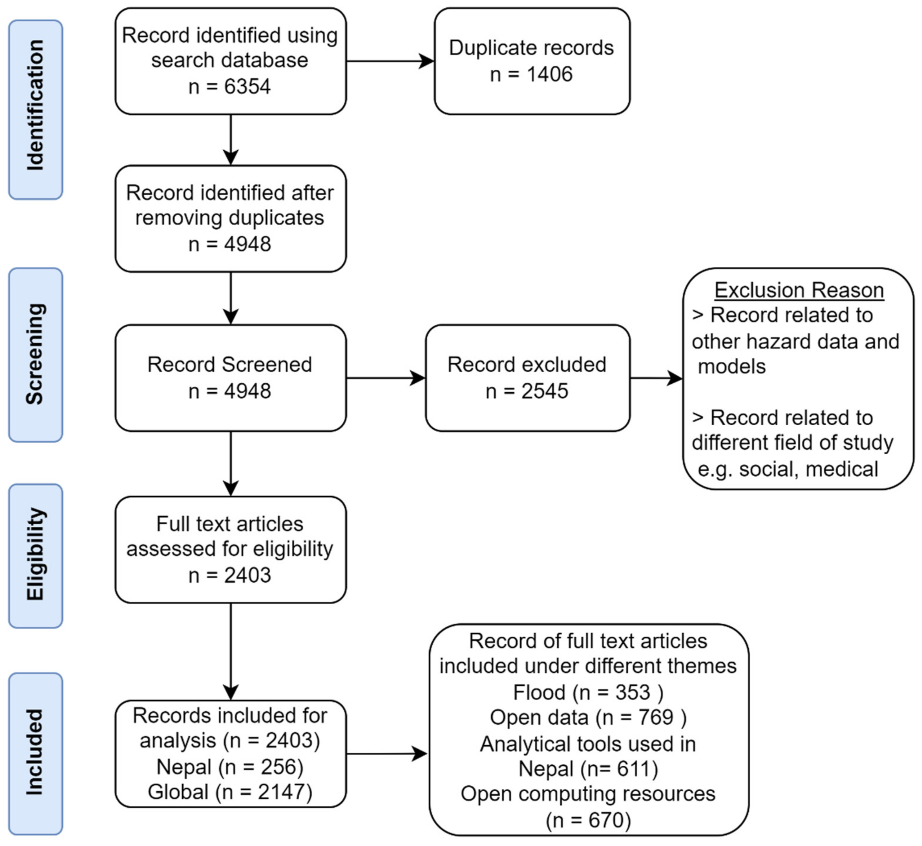
The data for this study were collected from the Web of Science and Scopus database using keywords. In addition, the data for this study were included published official reports of the government and non-government organizations and other documentation. The date range for the selected literature was from 1 January 1983 to 31 December 2021. The review first focused on risk assessment, then narrowed down to open data and most importantly on methods in analyzing the available data in producing meaningful information. The keywords and the number of articles selected for this study are presented in Table 1. Both the citation and keyword network analyses were performed. For example, the number of articles listed using the keywords on the Web of Science was 4948 during the first phase. A total of 2403 relevant articles were identified among which 256 were from Nepal and 2147 from various parts of the globe as illustrated in Figure 2.
Table 1.
Details of the key words and articles screened for the analysis.
Figure 2.
PRISMA flow diagram of the study.
2.2. Data Analysis and Validation
The data are presented in graphical and tabular formats. Both descriptive and quantitative analyses were used. Strengths, weaknesses, and future scope of open-source data and analytical models for flood hazards and risk assessments are discussed.
The review was further refined and validated through an online expert consultation meeting, organized in Kathmandu, Nepal. The participants in the meeting were experts, researchers, practitioners, and planners from various research fields in the DRRM sector. Based on the result of primary review, the participants were consulted on the available data types, data sources, data collection methods, and analytical models and their usefulness and applicability in the context of Nepal.
3. Results and Discussion
3.1. Earth Observation Data
Satellite products are invaluable for flood hazards and risk analysis as they provide the basis for the extraction of different earth feature data [31]. Different GIS layers can be derived from Earth observation data (Optical, LiDAR, and microwave radar data) for a large-scale flood-related functional evaluation [32,33]. These include maps of hydrogeomorphic units, ditches, vegetation, biomass, and wetland boundaries. Mapping of different impacts and functions over large areas can serve as an efficient tool for policymakers and other stakeholders [33]. Specifically, this earth observation satellite has the potential for mapping of flood hazards and their impacts. The open-source satellite products are presented in Table 2.
Table 2.
Some open access earth observation mission and products.
Landsat imagery archive, ESA Sentinel data, and ASTER in 2015 are open access EO products. Declassified historic satellite imagery since the 1960s can provide high-resolution information related to the earth’s surface [44]. Landsat mission began in the early 1970s and it provided its data openly in January 2008 [45]. It now has the longest time-series data on earth observation [46]. Copernicus Sentinel mission was another EO mission to provide high-resolution data open access [47]. Advanced Space-borne Thermal Emission and Reflection Radiometer (ASTER) was initially a commercial product, but in 2015, made all their data publicly available [48]. Unlike, Landsat, data of ASTER are not acquired at a regular time interval for the same location. Data are acquired as per the demand of the authorized personnel. Similarly, data of Corona, Argon and Lanyard were declassified in 1995, and Gambit and Hexagon satellite imagery in 2002. Some of these data sources are older and may not be available for future use, yet they are important to generate and reconstruct historical hazards and disaster events.
Currently, the DEMs that have nearly global coverage and free access are SRTM and ASTER GDEM [49]. In addition, recently, ALOS PALSAR L-band SAR based DEM of 12.5 m resolution was released (Table 3). Various flood and other hazard risk applications have already been implemented using these products [50,51].
Table 3.
List of open Digital Elevation Models (DEMs).
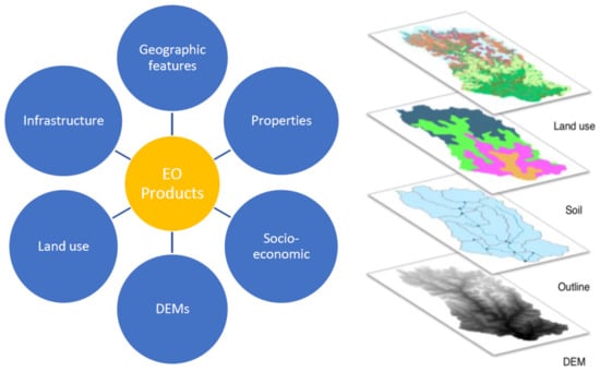
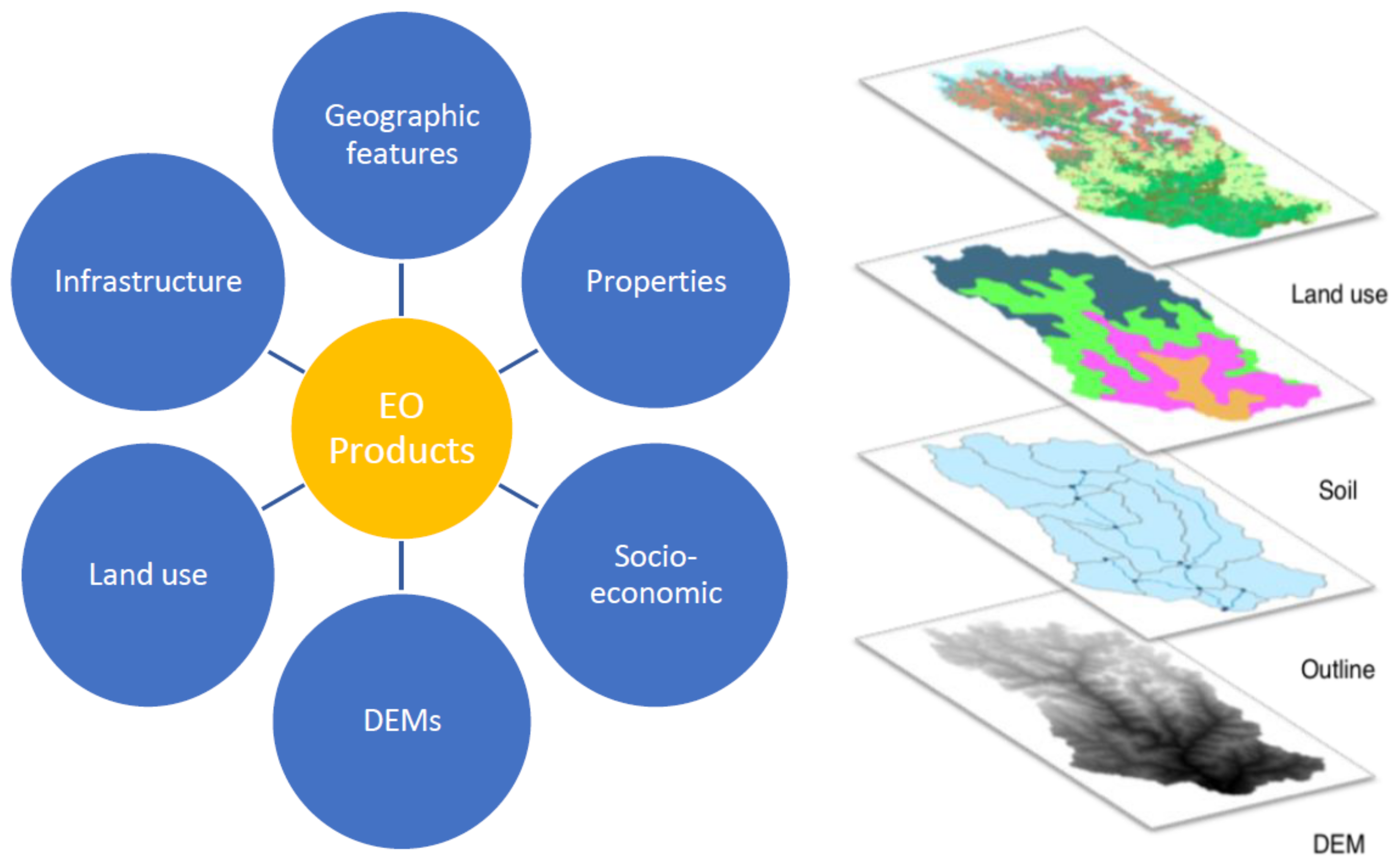
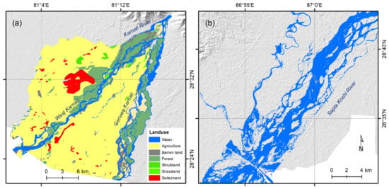
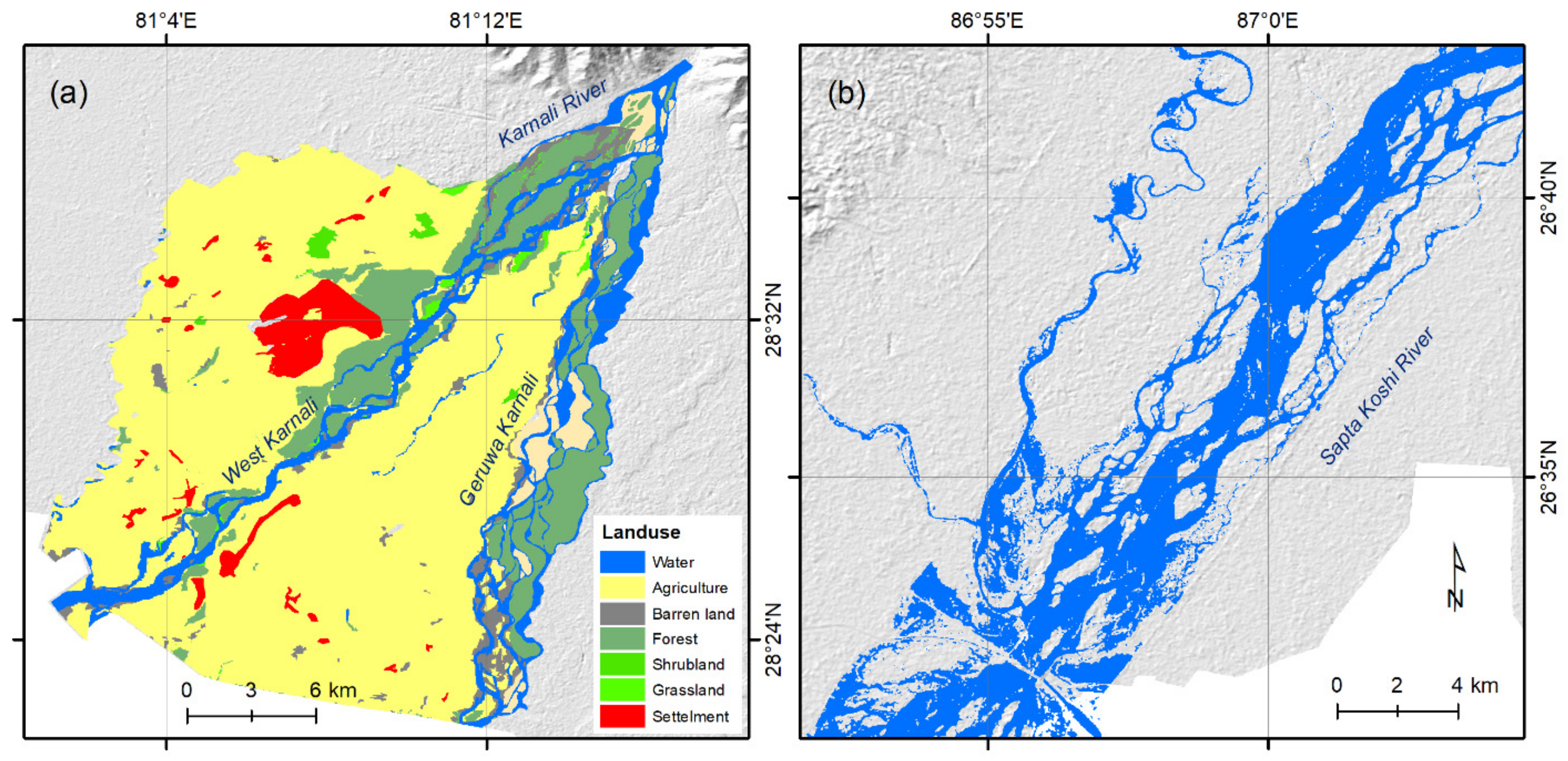
Open-source multi-resolution data from the latest EO technologies (Figure 3) is used for flood risk assessment and simulation of flood hydrodynamics to provide spatial and temporal flood characteristics [57]. A study on flood early warning system in the Karnali shows that the benefit-cost ratio is between 24 and 73% [58]. The benefit-cost ratio of the flood Early Warning System (EWS) can be increased by using open-source data and tools. Microwave data, such as Sentinel-1 SAR, can be very useful data for monitoring the floodwaters [59,60]. These data have a certain benefit over the optical data [61]. Precipitation is one of the key data required for flood hazards assessment. Sun and others [62] reviewed 30 different global precipitation products including regular gridded station-based, satellite-based, and reanalysis precipitation data. Some satellite-derived precipitation products are now available, including the Tropical Rainfall Measuring Mission (TRMM) [63], the Precipitation Estimation from Remotely Sensed Information using Artificial Neural Networks (PERSIANN) [64], and the Climate Prediction Center (CPC) morphing technique (CMORPH) [65] products. These are widely used in flood simulation and forecasting. An example of flood extent mapping using open-source data (Sentinel) is given in Figure 4.
Figure 3.
Different remote sensing data necessary for risk assessment (left) and thematic layers used to store the specific spatial information in the GIS database (e.g., Dudh Koshi River basin in Nepal) (right).
Figure 4.
Mapping of flood extent using open source Optical and Radar data, prepared by Authors as examples in this study: (a) Flood extent and land use mapping of the lower Karnali River using Optical imagery of Sentinel 2A of 12 October 2019 and (b) Flood mapping of the Koshi River of Nepal using Sentinel-1 SAR data of 12 July 2020 (summer monsoon) as an example. Background represents the hillshade from the ASTER GDEM. The optical data during the monsoon are rarely usable as they are affected by the cloud cover; the SAR data can be the best choice to overcome such issues.
3.2. Geospatial Data
Many open data repositories at different scales are available that provide different geographic data, statistics including socio-economic and scientific data, that can potentially be used for understanding the disaster risks in Nepal (Table 4). Detailed information on communities and infrastructure systems can be collected and processed from multiple sources including OpenStreetMap, Google Earth, and global data products to support impact analysis. Usually, the data generated and shared by the public organizations are considered as open-source. Data sharing policy and copyright information does not exist in the data generated by the national institutions/organization; however, over the past five years, there has been progressing in sharing of the government data online [66]. Apart from the national institutions and private sectors, international organizations provide information on different development indicators.
Table 4.
Geographic open and public data sources in Nepal and their characteristics.
3.3. Analytical Models for Flood Hazard and Risk Assessment
Analytical models use advanced statistical techniques and approaches in the modeling of extreme events and making predictions about the mechanisms involved in complex physical processes. These models have mainly been used for predicting system behavior and understanding various hydrological and hydrodynamics processes in terms of assessing hazards and risk.
Hydrological models are developed and used for both river and floodplain modelling to analyze the behavior of flooding and to identify the causes and effects of flooding [99]. These models help to assess the flood frequency for the quantitative assessment of flood problems in the area and prepare flood risk, vulnerability, and hazard maps. Many models are available for flood hazard mapping and assessment and are applied in the Nepalese context [1]. Both one-dimensional (1D) and two-dimensional (2D) dynamic flood models are used [100]. A basic probabilistic model can be used to assess flood risk in addition to complex deterministic models. Depending on the context, these models have their own advantage and shortcomings [101,102]. The integrated assessment of flood hazards in flood-prone locations, the cost-benefit analysis, and the risk-based design of flood protection systems could all benefit from the adoption of such models [102]. The techniques utilized in modeling range from very simple approaches with many simplifying assumptions to quite complex applications that involve a lot of data and computation time for both the hazard and vulnerability components of the risk. Studies have shown that combinations of different models (e.g., 1D/2D) would offer optimum balance between the amount of data needed for the simulation and the accuracy of the result [103]. The detailed list of the flood analytical models with their temporal and spatial scale and outputs are given in Table 5. Some of the common models used in Nepal are described below:
3.3.1. Hydrodynamic Model
HEC-GeoRAS is used for interfacing between the HEC-RAS and GIS used for flood inundation mapping based on the flow rates for different return periods using the HEC-RAS model, and GIS for spatial data processing [104].
3.3.2. Hydraulic Models
HEC-RAS is a commonly used hydraulic modelling software in Nepal that is used for flood hazard mapping [1,105]. HEC-RAS can perform steady and unsteady flow hydraulics, sediment transport/mobile bed computations, and water temperature modelling [99].
3.3.3. Hydrological Models
To evaluate the hydrology of watersheds, spatially dispersed hydrological models are employed, including HEC-HMS [106,107], InVEST [108,109], VIC [110], and SWAT [111,112,113]. The SWAT has been most widely implemented in hydrological studies and is applicable under limited data availability [114,115].
Table 5.
List of analytical models used for flood studies in Nepal.
3.4. Analytical Platforms, GIS Software and Programming Languages
The integration of available data and outputs from the model is supported by a risk assessment platform which helps in interactive risk assessment and further support in decision-making [132]. Some commonly available open-source web-based flood risk assessment platforms along with their main characteristics are given in Table 6.
Table 6.
Open-source online platform for the flood risk assessment.
Several open-source software programs provide support in modelling and analyzing hazard and risk data, and visualizing and exploring the data. Concerning disaster management applications, the most important software is the Geographic Information Systems (GIS) software, which is used to create, manage, store, analyze, and visualize geographic data. Chen and others [158] reviewed and summarized the open-source GIS software intending to apply it in water resource management. Table 7 presents open-source desktop GIS, whose functionalities are comparable to that of proprietary software.
Table 7.
Open-source GIS program/software application for flood risk assessment.
Programming languages are used to develop programs and models. There is an increase in the use of programming languages by scientists because of the ease with which they can derive insights from large and complex datasets [189]. The general purpose of programming languages like Python and R is for data analysis and to develop modelling applications. Table 8 explains the common and useful programming languages and notebook environments used for different computing results.
Notebooks are a computing environment where one can freely combine human-readable narrative with computer-readable code. In this environment, one can document the code, run it, visualize data, and see the results without leaving the environment. This makes it a useful tool for performing end to end data science workflows–data cleaning, statistical modeling, visualizing data, and many other uses.
Table 8.
Programming languages used for computing.
3.5. Machine Learning Models
Artificial neural networks (ANN), support vector machines (SVM), and decision trees (DT) are just a few examples of machine learning techniques that have been used to detect and analyze flood-prone zones in flood hazard assessments [160,197,198]. The machine learning models circumvent the subjective calculation of weights by learning the link between flooding incidence and the explanatory variables from the historical flooding records [199]. Global flood models frequently need many model parameters, frequent model debugging, and lengthy computation times due to the complexities of global floods. For quicker access to worldwide flood risk assessments, machine learning techniques could be a useful option [200].
EO products can be used to map and simulate the flood and provide flood characteristics; however, there is a problem of obtaining cloud-free images during the summer monsoon flooding season through the optical sensors (Sentinel 2a/2b, Landsat). Most optical imagery is full of cloud cover and cannot map the flooding. Even the microwave is absorbed by the water and thus may not be suitable for mapping the monsoon flood. To overcome this issue, the only option is to use the modelling of the flood extents or field survey using high-resolution drone mapping.
Disasters are the key barriers to achieving sustainable development targets with huge economic and societal impacts. The Sendai Framework for Disaster Risk Reduction 2015–2030 has set four main priorities for governments to focus on: (a) understanding disaster risk, (b) strengthening disaster risk governance to manage risks, (c) investing on DRR for resilience building, and (d) enhancing disaster preparedness for effective response and ‘building back better’ in recovery, rehabilitation, and reconstruction [201]. The developing countries are on the frontline to bear such negative impacts due to having the inadequate capacity to mitigate, adapt, and bounce back to normal condition after the crisis. Natural hazards are often hard to control, but with the proper understanding of their underlying risks and required planning to address those risks, losses could be minimized to a great extent; however, any plan for effective intervention to minimize the associated risks should be backed up by data and scientific evidence. Amongst other factors, the lack of data and reliable information sources are major hindrances in effective decision making especially in terms of a development initiative.
Previous works proposed and discussed the models for effective use of the open data [202,203]. Open data policies at various institutional and government levels are much less systematic [204]. Charalabidis and others [23] summarize the benefits of open data. Some previous documents evaluated the availability of open data in Nepal [65]. The lack of official mechanisms for the public sharing of data produced by the government is the major hindrance in open data initiatives. Despite this challenge, civil society organizations and the private sectors are taking steps to share both their data and the data from the government [65].
The review of open-access software packages by the World Bank provides a detailed evaluation of 31 models in disaster applications at the global level [12]. The report facilitates the choice of open access hazard and risk modelling tools in disaster risk management. Validation and application of the open data are undergoing with cases in different countries, e.g., flooding in Bangladesh using recent technologies, such as SAR [5], geographic data for flood disaster [22]. Previous studies also present the limitations of the remote sensing data [205].
4. Conclusions
The literature on the use of EO products, open data, and analytical models in flood hazards and risks, shows a growing interest in the field; however, the main focus of the contemporary literature is on the technology-specific applications for hazard mapping and disaster management.
Despite the availability of the open data, (a) a situation of an extremely low usage of such data are observed for most of the floods in Nepal, and (b) hazard mapping and impact evaluations in the country are limited and the capability of the available data are not explored in the country. Except for the case of study-based approaches, the disintegrated data by the local, provincial, and federal level was not found in Nepal. This might be related to the lack of efficient infrastructure (super computing device for the processing of big data), availability of human resources, and low priority of the country. Cloud computing resources, such as Google Earth Engine, can be the best alternative for filling the gap in the lack of efficient infrastructure in the country. The latest EO products and technologies, open data and analytical tools, have the potential to ensure efficient flood risk assessment, reduce the impacts of flood hazards, and flood risk reduction through the prior mitigation actions.
Producing intermediate data and indicators through the open satellite imagery, online platform (e.g., GoogleEarth Engine), and DEMs will be inputs for flood risk assessment. Multiple sources of data from different models and platforms, if combined and analyzed further, could produce a new result to better understand the risks and mitigation measures related to various kinds of disasters. Such datasets can be organized, managed, and analyzed using a digital, web-based analytical platform, which uses readily available open data sources from different flood models and produces user tailored information. Such outputs could be more understandable and guide evidence-based decision making and planning processes in the target areas.
This study documents the available open data, analytical models, and tools for flood risk assessment and underlines the potential of utilizing open data and tools for disaster risk reduction. Flood risk management requires an understanding of risk mechanism including hazard, impacts, susceptibility, and selection of management interventions. However, this study is focused mostly on the data and model for risk assessment including vulnerability and susceptibility analysis. Other models and data sources for flood control technical designs, cost–benefits analysis, and possible flood management options can be considered in similar future studies.
Author Contributions
Conceptualization, S.T. and B.P.P.; methodology, S.T., B.P.P. and P.S.; writing—original draft preparation, S.T., B.P.P., P.S., P.B. and D.P.; writing—review and editing, S.T. and R.C. All authors have read and agreed to the published version of the manuscript.
Funding
This research received no external funding.
Data Availability Statement
Not applicable.
Conflicts of Interest
The authors declare no conflict of interest.
References
- Aryal, D.; Wang, L.; Adhikari, T.R.; Zhou, J.; Li, X.; Shrestha, M.; Wang, L.; Chen, D. A Model-Based Flood Hazard Mapping on the Southern Slope of Himalaya. Water 2020, 12, 540. [Google Scholar] [CrossRef] [Scilit]
- Cabrera, J.S.; Lee, H.S. Flood risk assessment for Davao Oriental in the Philippines using geographic information system-based multi-criteria analysis and the maximum entropy model. J. Flood Risk Manag. 2020, 13, e12607. [Google Scholar] [CrossRef] [Scilit]
- Borah, S.B.; Sivasankar, T.; Ramya, M.N.S.; Raju, P.L.N. Flood inundation mapping and monitoring in Kaziranga National Park, Assam using Sentinel-1 SAR data. Environ. Monit. Assess. 2018, 190, 520. [Google Scholar] [CrossRef] [Scilit] [PubMed]
- Aksha, S.K.; Resler, L.M.; Juran, L.; Carstensen, L.W., Jr. A geospatial analysis of multi-hazard risk in Dharan, Nepal. Geomat. Nat. Hazards Risk 2020, 11, 88–111. [Google Scholar] [CrossRef] [Scilit]
- Aggarwal, A. Exposure, hazard and risk mapping during a flood event using open source geospatial technology. Geomat. Nat. Hazards Risk 2016, 7, 1426–1441. [Google Scholar] [CrossRef] [Scilit]
- Du, X.; Lin, X. Conceptual model on regional natural disaster risk assessment. Procedia Eng. 2012, 45, 96–100. [Google Scholar] [CrossRef] [Scilit]
- Kappes, M.S.; Keiler, M.; von Elverfeldt, K.; Glade, T. Challenges of analyzing multi-hazard risk: A review. Nat. Hazards 2012, 64, 1925–1958. [Google Scholar] [CrossRef] [Scilit]
- Sekhri, S.; Kumar, P.; Fürst, C.; Pandey, R. Mountain specific multi-hazard risk management framework (MSMRMF): Assessment and mitigation of multi-hazard and climate change risk in the Indian Himalayan Region. Ecol. Indic. 2020, 118, 106700. [Google Scholar] [CrossRef] [Scilit]
- Ahamed, A.; Bolten, J.; Doyle, C.; Fayne, J. Near real-time flood monitoring and impact assessment systems. In Remote Sensing of Hydrological Extremes; Springer: Cham, Switzerland, 2017; pp. 105–118. [Google Scholar]
- Mishra, K.; Sinha, R. Flood risk assessment in the Kosi megafan using multi-criteria decision analysis: A hydro-geomorphic approach. Geomorphology 2020, 350, 106861. [Google Scholar] [CrossRef] [Scilit]
- Towe, R.; Dean, G.; Edwards, L.; Nundloll, V.; Blair, G.; Lamb, R.; Hankin, B.; Manson, S. Rethinking data-driven decision support in flood risk management for a big data age. J. Flood Risk Manag. 2019, 13, e12652. [Google Scholar] [CrossRef] [Scilit]
- GFDRR (Global Facility for Disaster Reduction and Recovery). Understanding Risk: Review of Open Source and Open Access Software Packages Available to Quantify Risk from Natural Hazards; International Bank for Reconstruction and Development/International Development Association or The World Bank: Washington, DC, USA, 2014. [Google Scholar]
- Sudmeier, K.I.; Jaboyedoff, M.; Jaquet, S. Operationalizing “resilience” for disaster risk reduction in mountainous Nepal. Disaster Prev. Manag. 2013, 22, 366–377. [Google Scholar] [CrossRef] [Scilit]
- Sudmeier-Rieux, K.; Gaillard, J.C.; Sharma, S.; Dubois, J.; Jaboyedoff, M. Floods, landslides, and adapting to climate change in Nepal: What role for climate change models? In Climate Change Modeling for Local Adaptation in the Hindu Kush-Himalayan Region; Emerald Group Publishing Limited: Bingley, UK, 2012. [Google Scholar]
- MoHA. National Disaster Report; Disaster Preparedness Network Nepal (DPNet-Nepal); Ministry of Home Affairs (MoHA), Government of Nepal: Kathmandu, Nepal, 2013. [Google Scholar]
- NPC. Nepal Flood 2017: Post Flood Recovery Needs Assessment; Government of Nepal, National Planning Commission: Kathmandu, Nepal, 2017. [Google Scholar]
- Pinos, J.; Orellana, D.; Timbe, L. Assessment of microscale economic flood losses in urban and agricultural areas: Case study of the Santa Bárbara River, Ecuador. Nat. Hazards 2020, 103, 2323–2337. [Google Scholar] [CrossRef] [Scilit]
- Di, L.; Eugene, G.Y.; Kang, L.; Shrestha, R.; Bai, Y.Q. RF-CLASS: A remote-sensing-based flood crop loss assessment cyber-service system for supporting crop statistics and insurance decision-making. J. Integr. Agric. 2017, 16, 408–423. [Google Scholar] [CrossRef] [Scilit]
- Eugene, G.Y.; Di, L.; Rahman, M.S.; Lin, L.; Zhang, C.; Hu, L.; Shrestha, R.; Kang, L.; Tang, J.; Yang, G. Performance improvement on a Web Geospatial service for the remote sensing flood-induced crop loss assessment web application using vector tiling. In Proceedings of the 2017 6th International Conference on Agro-Geoinformatics, Fairfax, VA, USA, 7–10 August 2017; pp. 1–6. [Google Scholar]
- Delalay, M.; Ziegler, A.D.; Shrestha, M.S.; Wasson, R.J.; Sudmeier-Rieux, K.; McAdoo, B.G.; Kochhar, I. Towards improved flood disaster governance in Nepal: A case study in Sindhupalchok District. Int. J. Disaster Risk Reduct. 2018, 31, 354–366. [Google Scholar] [CrossRef] [Scilit]
- Gaire, S.; Delgado, R.C.; González, P.A. Disaster risk profile and existing legal framework of Nepal: Floods and landslides. Risk Manag. Healthc. Policy 2015, 8, 139. [Google Scholar] [CrossRef] [Scilit]
- Sharma, T.P.P.; Zhang, J.; Koju, U.A.; Zhang, S.; Bai, Y.; Suwal, M.K. Review of flood disaster studies in Nepal: A remote sensing perspective. Int. J. Disaster Risk Reduct. 2019, 34, 18–27. [Google Scholar] [CrossRef] [Scilit]
- Charalabidis, Y.; Zuiderwijk, A.; Alexopoulos, C.; Janssen, M.; Lampoltshammer, T.; Ferro, E. The World of Open Data. In Public Administration and Information Technology; Springer International Publishing: Cham, Switzerland, 2018; Volume 10, pp. 978–983. [Google Scholar]
- Great Britain Cabinet Office. Open Data White Paper: Unleashing the Potential; The Stationery Office: London, UK, 2012; Volume 8353. [Google Scholar]
- Ospina, A.V. Big Data for Resilience Storybook: Experiences Integrating Big Data into Resilience Programming; Canada International Institute for Sustainable Development: Winnipeg, MB, Canada, 2018. [Google Scholar]
- Nicoson, C.; Uexkull, N.V. Overlapping Vulnerabilities: The Impacts of Climate Change on Humanitarian Needs; Norwegian Red Cross: Oslo, Norway, 2019. [Google Scholar]
- Kankanamge, N.; Yigitcanlar, T.; Goonetilleke, A.; Kamruzzaman, M. Can volunteer crowdsourcing reduce disaster risk? A systematic review of the literature. Int. J. Disaster Risk Reduct. 2019, 35, 101097. [Google Scholar] [CrossRef] [Scilit]
- Dewey, A.; Drahota, A. Introduction to Systematic Reviews: Online Learning Module Cochrane Training. 2016. Available online: https://training.cochrane.org/interactivelearning/module-1-introduction-conducting-systematic-reviews (accessed on 16 September 2020).
- Gough, D.A.; Gough, D.; Oliver, S.; Thomas, J. An Introduction to Systematic Reviews; SAGE: London, UK, 2012. [Google Scholar]
- Page, M.J.; McKenzie, J.E.; Bossuyt, P.M.; Boutron, I.; Hoffmann, T.C.; Mulrow, C.D.; Shamseer, L.; Tetzlaff, J.M.; Akl, E.A.; Brennan, S.E.; et al. The PRISMA 2020 statement: An updated guideline for reporting systematic reviews. Syst. Rev. 2021, 10, 89. [Google Scholar] [CrossRef] [Scilit]
- Skakun, S.; Kussul, N.; Shelestov, A.; Kussul, O. Flood Hazard and Flood Risk Assessment Using a Time Series of Satellite Images: A Case Study in Namibia. Risk Anal. Off. Publ. Soc. Risk Anal. 2014, 34, 1521–1537. [Google Scholar] [CrossRef] [Scilit]
- Jiang, Y.; Sun, M.; Yang, C. A generic framework for using multi-dimensional earth observation data in GIS. Remote Sens. 2016, 8, 382. [Google Scholar] [CrossRef] [Scilit]
- Rapinel, S.; Hubert-Moy, L.; Clement, B.; Maltby, E. Mapping wetland functions using Earth observation data and multi-criteria analysis. Environ. Monit. Assess. 2016, 188, 641. [Google Scholar] [CrossRef] [Scilit] [PubMed]
- Casana, J. Global-Scale Archaeological Prospection using CORONA Satellite Imagery: Automated, Crowd-Sourced, and Expert-led Approaches. J. Field Archaeol. 2020, 45 (Suppl. 1), S89–S100. [Google Scholar] [CrossRef] [Scilit]
- Galiatsatos, N. Assessment of the CORONA Series of Satellite Imagery for Landscape Archaeology: A Case Study from the Orontes Valley, Syria. Ph.D. Thesis, Durham University, Durham, UK, 2004. [Google Scholar]
- Ye, W.; Qiao, G.; Kong, F.; Ma, X.; Tong, X.; Li, R. Improved Geometric Modeling of 1960s KH-5 ARGON Satellite Images for Regional Antarctica Applications. Photogramm. Eng. Remote Sens. 2017, 83, 477–491. [Google Scholar] [CrossRef] [Scilit]
- Mi, H.; Qiao, G.; Li, T.; Qiao, S. Declassified Historical Satellite Imagery from 1960s and Geometric Positioning Evaluation in Shanghai, China. In International Conference on Geo-Informatics in Resource Management and Sustainable Ecosystem; Springer: Berlin/Heidelberg, Germany, 2014; pp. 283–292. [Google Scholar]
- Fowler, M.J. The application of declassified KH-7 GAMBIT satellite photographs to studies of Cold War material culture: A case study from the former Soviet Union. Antiquity 2008, 82, 714–731. [Google Scholar] [CrossRef] [Scilit]
- Fowler, M.J. The archaeological potential of declassified HEXAGON KH-9 panoramic camera satellite photographs. AARG News 2016, 53, 30–36. [Google Scholar]
- Thapa, S.; Shrestha, A.; Lamichhane, S.; Adhikari, R.; Gautam, D. Catchment-scale flood hazard mapping and flood vulnerability analysis of residential buildings: The case of Khando River in eastern Nepal. J. Hydrol. Reg. Stud. 2020, 30, 100704. [Google Scholar] [CrossRef] [Scilit]
- Tavus, B.; Kocaman, S.; Nefeslioglu, H.A.; Gokceoglu, C. A fusion approach for flood mapping using Sentinel-1 and Sentinel-2 datasets. Int. Arch. Photogramm. Remote Sens. Spat. Inf. Sci. 2020, 43, 641–648. [Google Scholar] [CrossRef] [Scilit]
- Tripathi, G.; Pandey, A.C.; Parida, B.R.; Shakya, A. Comparative Flood Inundation Mapping Utilizing Multi-Temporal Optical and SAR Satellite Data over North Bihar Region: A Case Study of 2019 Flooding Event over North Bihar. In Spatial Information Science for Natural Resource Management; IGI Global: Hershey, PA, USA, 2020; pp. 149–168. [Google Scholar]
- Bhatta, B.; Shrestha, S.; Shrestha, P.K.; Talchabhadel, R. Modelling the impact of past and future climate scenarios on streamflow in a highly mountainous watershed: A case study in the West Seti River Basin, Nepal. Sci. Total Environ. 2020, 740, 140156. [Google Scholar] [CrossRef] [Scilit]
- Ur, J. Spying on the past: Declassified intelligence satellite photographs and near eastern landscapes. Near East. Archaeol. 2013, 76, 28–36. [Google Scholar] [CrossRef] [Scilit]
- Woodcock, C.E.; Allen, R.; Anderson, M.; Belward, A.; Bindschadler, R.; Cohen, W.; Gao, F.; Goward, S.N.; Helder, D.; Helmer, E.; et al. Free access to Landsat imagery. Science 2008, 320, 1011. [Google Scholar] [CrossRef] [Scilit]
- Goward, S.; Arvidson, T.; Williams, D.; Faundeen, J.; Irons, J.; Franks, S. Historical record of Landsat global coverage. Photogramm. Eng. Remote Sens. 2006, 72, 1155–1169. [Google Scholar] [CrossRef] [Scilit]
- Aschbacher, J. ESA’s earth observation strategy and Copernicus. In Satellite Earth Observations and Their Impact on Society and Policy; Springer: Singapore, 2017; pp. 81–86. [Google Scholar]
- Abrams, M.; Tsu, H.; Hulley, G.; Iwao, K.; Pieri, D.; Cudahy, T.; Kargel, J. The advanced spaceborne thermal emission and reflection radiometer (ASTER) after fifteen years: Review of global products. Int. J. Appl. Earth Obs. Geoinf. 2015, 38, 292–301. [Google Scholar] [CrossRef] [Scilit]
- Hu, Z.; Peng, J.; Hou, Y.; Shan, J. Evaluation of recently released open global digital elevation models of Hubei, China. Remote Sens. 2017, 9, 262. [Google Scholar] [CrossRef] [Scilit]
- Toutin, T. ASTER DEMs for geomatic and geoscientific applications: A review. Int. J. Remote Sens. 2008, 29, 1855–1875. [Google Scholar] [CrossRef] [Scilit]
- Akbari, A.; Ramli, N.I.B.; Kong, N.S. Application of public domain satellite-based DEMs in natural hazard modeling. Int. J. Environ. Sci. Dev. 2016, 7, 140. [Google Scholar] [CrossRef] [Scilit]
- NASA. NASA Shuttle Radar Topography Mission Global 1 Arc Second. 2020. Available online: http://cgiarcsi.community/data/srtm-90m-digital-elevation-database-v4-1/ (accessed on 20 July 2020).
- Sampson, C.C.; Smith, A.M.; Bates, P.D.; Neal, J.C.; Trigg, M.A. Perspectives on open access high resolution digital elevation models to produce global flood hazard layers. Front. Earth Sci. 2016, 3, 85. [Google Scholar] [CrossRef] [Scilit]
- Sampson, C.C.; Smith, A.M.; Bates, P.D.; Neal, J.C.; Alfieri, L.; Freer, J.E. A high-resolution global flood hazard model. Water Resour. Res. 2015, 51, 7358–7381. [Google Scholar] [CrossRef] [Scilit]
- Rignot, E. Changes in West Antarctic ice stream dynamics observed with ALOS PALSAR data. Geophys. Res. Lett. 2008, 35, L12505. [Google Scholar] [CrossRef] [Scilit]
- Watson, C.S.; Kargel, J.S.; Tiruwa, B. UAV-derived Himalayan topography: Hazard assessments and comparison with global dem products. Drones 2019, 3, 18. [Google Scholar] [CrossRef] [Scilit]
- Chen, H.; Liang, Q.; Zhao, J.; Xia, X. High-resolution glacial lake outburst flood impact evaluation using high-performance hydrodynamic modelling and open-source data. In EGU General Assembly Conference Abstracts; EGU: Vienna, Austria, 2020; p. 3714. [Google Scholar]
- Rai, R.K.; van den Homberg, M.J.; Ghimire, G.P.; McQuistan, C. Cost-benefit analysis of flood early warning system in the Karnali River Basin of Nepal. Int. J. Disaster Risk Reduct. 2020, 47, 101534. [Google Scholar] [CrossRef] [Scilit]
- Uddin, K.; Matin, M.A.; Meyer, F.J. Operational flood mapping using multi-temporal sentinel-1 SAR images: A case study from Bangladesh. Remote Sens. 2019, 11, 1581. [Google Scholar] [CrossRef] [Scilit]
- Li, Y.; Martinis, S.; Plank, S.; Ludwig, R. An automatic change detection approach for rapid flood mapping in Sentinel-1 SAR data. Int. J. Appl. Earth Obs. Geoinf. 2018, 73, 123–135. [Google Scholar] [CrossRef] [Scilit]
- Shen, X.; Anagnostou, E.N.; Allen, G.H.; Brakenridge, G.R.; Kettner, A.J. Near-real-time non-obstructed flood inundation mapping using synthetic aperture radar. Remote Sens. Environ. 2019, 221, 302–315. [Google Scholar] [CrossRef] [Scilit]
- Sun, Q.; Miao, C.; Duan, Q.; Ashouri, H.; Sorooshian, S.; Hsu, K.L. A review of global precipitation data sets: Data sources, estimation, and intercomparisons. Rev. Geophys. 2018, 56, 79–107. [Google Scholar] [CrossRef] [Scilit]
- Harris, A.; Rahman, S.; Hossain, F.; Yarborough, L.; Bagtzoglou, A.C.; Easson, G. Satellite-based flood modeling using TRMM-based rainfall products. Sensors 2007, 7, 3416–3427. [Google Scholar] [CrossRef] [Scilit]
- Ashouri, H.; Hsu, K.L.; Sorooshian, S.; Braithwaite, D.K.; Knapp, K.R.; Cecil, L.D.; Nelson, B.R.; Prat, O.P. PERSIANN-CDR: Daily precipitation climate data record from multisatellite observations for hydrological and climate studies. Bull. Am. Meteorol. Soc. 2015, 96, 69–83. [Google Scholar] [CrossRef] [Scilit]
- Joyce, R.J.; Janowiak, J.E.; Arkin, P.A.; Xie, P. CMORPH: A method that produces global precipitation estimates from passive microwave and infrared data at high spatial and temporal resolution. J. Hydromet. 2004, 5, 487–503. [Google Scholar] [CrossRef] [Scilit]
- Dennison, L.; Rana, P. Nepal’s Emerging Data Revolution; Background Paper; Development Initiatives: Kathmandu, Nepal, 2017; p. 26. [Google Scholar]
- Basnyat, D.B.; Shrestha, D.; Thapa, S.; Bajimaya, S.; Maharjan, M.; Shrestha, S.; Dhungana, S. Post-Flood Assessment of the 2019 Flooding in the Bagmati River Basin, Nepal. J. Dev. Innov. 2020, 4, 20–47. [Google Scholar]
- MoHA/GoN 2020 Nepal Disaster Risk Reduction Portal. Ministry of Home Affairs, Government of Nepal. Available online: http://www.drrportal.gov.np/ (accessed on 20 October 2021).
- Rimal, B.; Baral, H.; Stork, N.E.; Paudyal, K.; Rijal, S. Growing city and rapid land use transition: Assessing multiple hazards and risks in the Pokhara Valley, Nepal. Land 2015, 4, 957–978. [Google Scholar] [CrossRef] [Scilit]
- Bajracharya, S.R.; Shrestha, M.S.; Shrestha, A.B. Assessment of high-resolution satellite rainfall estimation products in a streamflow model for flood prediction in the Bagmati basin, Nepal. J. Flood Risk Manag. 2017, 10, 5–16. [Google Scholar] [CrossRef] [Scilit]
- Rijal, S.; Rimal, B.; Sloan, S. Flood hazard mapping of a rapidly urbanizing city in the foothills (Birendranagar, Surkhet) of Nepal. Land 2018, 7, 60. [Google Scholar] [CrossRef] [Scilit]
- Currion, P.; Silva, C.D.; Van de Walle, B. Open source software for disaster management. Commun. ACM 2007, 50, 61–65. [Google Scholar] [CrossRef] [Scilit]
- Careem, M.; Bitner, D.; Silva, R. GIS integration in the Sahana disaster management system. In Proceedings of the International Conference on Information Systems for Crisis Response and Management, Delft, The Netherlands, 13–16 May 2007; p. 14. [Google Scholar]
- MoALD. Nepal Agriculture Management Information System. 2020. Available online: www.namis.gov.np (accessed on 26 September 2020).
- Regmi, S.; Shrestha, G.; Baral, B.R.; Rajbhandari, B.P. Adoption of climate smart agricultural technologies: Impact of agriculture management information system on rice production in Banke District, Nepal. J. Nep. Agric. Res. 2018, 17, 141. [Google Scholar]
- Shrestha, R.K.; Shrestha, R. Group segmentation and heterogeneity in the choice of cooking fuels in post-earthquake Nepal. arXiv 2020, arXiv:2005.09616. [Google Scholar]
- Olaniyan, F.A.; Adelekan, I.O.N.; Okocha, E.E. The Role of Local Governments in Reducing Disaster Losses and Vulnerabilities in Ibadan City, Nigeria; Working Paper; Urban Africa Risk Knowledge, UK Department for International Development and the Economic and Social Research Council: London, UK, 2020. [Google Scholar]
- Haklay, M.; Weber, P. Open Street map: User-generated Street maps. IEEE Pervasive Comput. 2008, 7, 12–18. [Google Scholar] [CrossRef] [Scilit]
- Chereni, S.; Sliuzas, R.V.; Flacke, J.; Maarseveen, M.V. The influence of governance rearrangements on flood risk management in Kampala, Uganda. Environ. Policy Gov. 2020, 30, 151–163. [Google Scholar] [CrossRef] [Scilit]
- Tiwari, K.R.; Awasthi, K.D.; Balla, M.K.; Sitaula, B.K. Local People’s Perception on Climate Change, Its Impact and Adaptation Practices in Himalaya to Terai Regions of Nepal; Nepal Study Center, University of New Mexico: Albuquerque, NM, USA, 2010. [Google Scholar]
- Trabucco, A.; Zomer, R.J. Global aridity index and potential evapotranspiration (ET0) climate database v2. CGIAR Consort Spat Inf. 2018, 10, m9. [Google Scholar]
- Kaushik, P.; Ghosh, P. 3D DEM delineation of Chambal River basin from SRTM data using remote sensing and GIS technology. Int. J. Remote Sens. Geosci. 2015, 4, 1–6. [Google Scholar]
- Gorokhovich, Y.; Voustianiouk, A. Accuracy assessment of the processed SRTM-based elevation data by CGIAR using field data from USA and Thailand and its relation to the terrain characteristics. Remote Sens. Environ. 2006, 104, 409–415. [Google Scholar] [CrossRef] [Scilit]
- Peduzzi, P.; Herold, C.; Mouton, F.; Dao, H.; Gregory, G.; Chatenoux, B. Global Human Exposure to Flood Hazard, Preview Global Risk Data Platform; UNEP/GRID-Geneva: Geneva, Switzerland, 2011. [Google Scholar]
- McGlade, J.; Bankoff, G.; Abrahams, J.; Cooper-Knock, S.J.; Cotecchia, F.; Desanker, P.; Erian, W.; Gencer, E.; Gibson, L.; Girgin, S.; et al. Global Assessment Report on Disaster Risk Reduction 2019; UN Office for Disaster Risk Reduction (UNDRR): Geneva, Switzerland, 2019. [Google Scholar]
- Tatem, A.J. WorldPop, open data for spatial demography. Sci. Data 2017, 4, 170004. [Google Scholar] [CrossRef] [Scilit]
- Roser, M.; Ortiz-Ospina, E. Our World in Data: Global Extreme Poverty; University of Oxford Martin School: Oxford, UK, 2013. [Google Scholar]
- Rashid, K. Flood Hazard Mapping for the Humanitarian Sector: An Opinion Piece on Needs and Views. In Global Flood Hazard: Applications in Modeling, Mapping, and Forecasting; Wiley: New York, NY, USA, 2018; pp. 115–130. [Google Scholar]
- Ahmed, B.; Rahman, M.S.; Sammonds, P.; Islam, R.; Uddin, K. Application of geospatial technologies in developing a dynamic landslide early warning system in a humanitarian context: The Rohingya refugee crisis in Cox’s Bazar, Bangladesh. Geomat. Nat. Hazards Risk 2020, 11, 446–468. [Google Scholar] [CrossRef] [Scilit]
- Bajracharya, R.; Khatiwada, A. Standardization of Risk Information Components on BIPAD; Youth Innovation Lab: Kathmandu, Nepal, 2020. [Google Scholar]
- Klaver, J.M.; Fosnight, E.A.; Singh, A. Global Forest Fire Watch: Wildfire Potential, Detection Monitoring and Assessment. In Proceedings of the First International Conference on Geospatial Information in Agriculture and Forestry, Lake Buena Vista, FL, USA, 1–3 June 1997. [Google Scholar]
- Stanojevic, Z.; Lee, P.G.; Gysbers, J.D. Recent Anthropogenic Changes within the Northern Boreal, Southern Taiga, and Hudson Plains Ecozones of Québec: A Global Forest Watch Canada Report; Global Forest Watch Canada: Edmonton, AB, Canada, 2006. [Google Scholar]
- Gaume, E.; Borga, M.; Llassat, M.C.; Maouche, S.; Lang, M.; Diakakis, M. Mediterranean Extreme Floods and Flash Floods. In The Mediterranean Region under Climate Change. A Sciencific Update; IRD Editions: Marseille, France, 2016; pp. 133–144. [Google Scholar]
- Michael, A.W.; Nicholas, C.C.; David, P.R.; Joanne, C.W.; Hermosilla, T. Land cover 2.0. Int. J. Remote Sens. 2018, 39, 4254–4284. [Google Scholar] [CrossRef] [Scilit]
- Brown, J.; Loveland, T.; Ohlen, D. The global land-cover characteristics database: The users’ perspective. Photogramm. Eng. Remote Sens. 1999, 65, 1069–1074. [Google Scholar]
- Nguyen, P.; Shearer, E.J.; Tran, H.; Ombadi, M.; Hayatbini, N.; Palacios, T.; Huynh, P.; Updegraff, G.; Hsu, K.; Kuligowski, B.; et al. The CHRS Data Portal, an easily accessible public repository for PERSIANN global satellite precipitation data. Sci. Data 2019, 6, 180296. [Google Scholar] [CrossRef] [Scilit]
- Kleist, D.; Parrish, D.; Derber, J.; Treadon, R.; Wu, W.; Lord, S. Introduction of the GSI into the NCEP Global Data Assimilation system. Weather Forecast. 2009, 24, 1691–1705. [Google Scholar] [CrossRef] [Scilit]
- Wei, Q.; Chi, Z.; Guangtao, F.; Huicheng, Z. Global Land Data Assimilation System data assessment using a distributed biosphere hydrological model. J. Hydrol. 2015, 528, 652–667. [Google Scholar] [CrossRef] [Scilit]
- Anees, M.T.; Abdullah, K.; Nordin, M.N.M.; Ab Rahman, N.N.N.; Syakir, M.I.; Kadir, M.O.A. One-and Two-Dimensional Hydrological Modelling and Their Uncertainties. Flood Risk Manag. 2017, 11, 221–244. [Google Scholar]
- Costabile, P.; Macchione, F.; Natale, L.; Petaccia, G. Flood mapping using LIDAR DEM. Limitations of the 1-D modeling highlighted by the 2-D approach. Nat. Hazards 2015, 77, 181–204. [Google Scholar] [CrossRef] [Scilit]
- Di Baldassarre, G.; Schumann, G.; Bates, P.D.; Freer, J.E.; Beven, K.J. Flood-Plain Mapping: A Critical Discussion of Deterministic and Probabilistic Approaches. Hydrol. Sci. J. 2010, 55, 364–376. [Google Scholar] [CrossRef] [Scilit]
- Apel, H.; Thieken, A.H.; Merz, B.; Blöschl, G. A Probabilistic Modelling System for Assessing Flood Risks. Nat. Hazards 2006, 38, 79–100. [Google Scholar] [CrossRef] [Scilit]
- Apel, H.; Aronica, G.T.; Kreibich, H.; Thieken, A.H. Flood Risk Analyses—How Detailed Do We Need to Be? Nat. Hazards 2009, 49, 79–98. [Google Scholar] [CrossRef] [Scilit]
- El-Naqa, A.; Jaber, M. Floodplain Analysis using ArcGIS, HEC-GeoRAS and HEC-RAS in Attarat Um Al-Ghudran Oil Shale Concession Area, Jordan. Int. J. Civ. Environ. Eng. 2018, 8, 1–11. [Google Scholar] [CrossRef] [Scilit]
- Pandey, P.; Dugar, S. Flood Hazard mapping in an urban context: A case study of Hanumante stream, Bhaktapur (Nepal). In Proceedings of the IOE Graduate Conference, Kathmandu, Nepal, 24–25 May 2019; Volume 6, pp. 435–444. [Google Scholar]
- Koneti, S.; Sunkara, S.L.; Roy, P.S. Hydrological modeling with respect to impact of land-use and land-cover change on the runoff dynamics in Godavari River Basin using the HEC-HMS model. ISPRS Int. J. Geo-Inform. 2018, 7, 206. [Google Scholar] [CrossRef] [Scilit]
- Younis, S.M.Z.; Ammar, A. Quantification of impact of changes in land use-land cover on hydrology in the upper Indus Basin, Pakistan. Egypt. J. Remote Sens. Space Sci. 2018, 21, 255–263. [Google Scholar] [CrossRef] [Scilit]
- Geng, X.; Wang, X.; Yan, H.; Zhang, Q.; Jin, G. Land Use/Land cover change induced impacts on water supply service in the Upper Reach of Heihe River Basin. Sustainability 2014, 7, 336–383. [Google Scholar] [CrossRef] [Scilit]
- Li, S.; Yang, H.; Lacayo, M.; Liu, J.; Lei, G. Impacts of land-use and land-cover changes on water yield: A case study in Jing-Jin-Ji China. Sustainability 2018, 10, 960. [Google Scholar] [CrossRef] [Scilit]
- Garg, V.; Prasun, S.P.A.; Bhaskar, K.G. Assessment of land use land cover change impact on hydrological regime of a basin. Environ. Earth Sci. 2017, 76, 2233–2240. [Google Scholar] [CrossRef] [Scilit]
- Kumar, L.; Mutanga, O. Google Earth Engine applications since inception: Usage, trends, and potential. Remote Sens. 2018, 10, 1509. [Google Scholar] [CrossRef] [Scilit]
- Li, F.; Zhang, G.; Li, H.; Lu, W. Land use change impacts on hydrology in the Nenjiang River Basin Northeast China. Forest 2019, 10, 476. [Google Scholar] [CrossRef] [Scilit]
- Munoth, P.; Goyal, R. Impacts of land use land cover change on runoff and sediment yield of Upper Tapi River Sub-Basin India. Int. J. River Basin Manag. 2020, 18, 177–189. [Google Scholar] [CrossRef] [Scilit]
- Stehr, A.; Debels, P.; Romero, F.; Stehr, A.; Debels, P.; Romero, F. Hydrological modelling with SWAT under conditions of limited data availability: Evaluation of results from a Chilean case study Hydrological modelling with SWAT under conditions of limited data availability: Evaluation of results from a Chilean case study. Hydrol. Sci. J. 2008, 53, 3588–3601. [Google Scholar] [CrossRef] [Scilit]
- Gassman, P.W.; Reyes, M.R.; Green, C.H.; Arnold, J.G. The soil and water assessment tool: Historical development. Appl. Future Res. Dir. 2007, 50, 1211–1250. [Google Scholar]
- Brunner, G.W. HEC-RAS River Analysis System User’s Manual Version 4.1; USACE Hydrologic Engineering Center: Washington DC, USA, 2010. [Google Scholar]
- Devkota, R.; Bhattarai, U.; Devkota, L.; Maraseni, T.N. Assessing the past and adapting to future floods: A hydro-social analysis. Clim. Chang. 2020, 163, 1065–1082. [Google Scholar] [CrossRef] [Scilit]
- Sheikh, V.; Visser, S.; Stroosnijder, L. A simple model to predict soil moisture: Bridging Event and Continuous Hydrological (BEACH) modelling. Environ. Model. Softw. 2009, 24, 542–556. [Google Scholar] [CrossRef] [Scilit]
- Smith, R.E.; Goodrich, D.C.; Quinton, J.N. Dynamic, distributed simulation of watershed erosion: The KINEROS2 and EUROSEM models. J. Soil Water Conserv. 1995, 50, 517–520. [Google Scholar]
- Aziz, A.; Tanaka, S. Regional parameterization and applicability of Integrated Flood Analysis System (IFAS) for flood forecasting of upper-middle Indus River. Pak. J. Meteorol. 2011, 8, 21–38. [Google Scholar]
- Werner, M.; van Dijk, M.; Schellekens, J. DELFT-FEWS: An open shell flood forecasting system. Hydroinformatics, 2 (with CD-ROM); World Scientific Publishing: Hackensack, NJ, USA, 2004; pp. 1205–1212. [Google Scholar]
- VanDrie, R.; Milevski, P. ANUGA–Free & Open Source 2-D Hydrodynamic Model, with Hydrologic Capability. In H2009: 32nd Hydrology and Water Resources Symposium, Newcastle: Adapting to Change: Adapting to Change; Engineers Australia: Barton, ACT, Australia, 2009; pp. 1138–1149. [Google Scholar]
- Terink, W.; Lutz, A.F.; Simons, G.W.H.; Immerzeel, W.W.; Droogers, P. SPHY v2. 0: Spatial processes in hydrology. Geosci. Model Dev. 2015, 8, 2009–2034. [Google Scholar] [CrossRef] [Scilit]
- Khanal, S.; Lutz, A.F.; Kraaijenbrink, P.D.; van den Hurk, B.; Yao, T.; Immerzeel, W.W. Variable 21st century climate change response for rivers in High Mountain Asia at seasonal to decadal time scales. Water Resour. Res. 2021, 57, e2020WR029266. [Google Scholar] [CrossRef] [Scilit]
- Bhattarai, S.; Zhou, Y.; Shakya, N.M.; Zhao, C. Hydrological modelling and climate change impact assessment using HBV light model: A case study of Narayani River Basin, Nepal. Nat. Environ. Pollut. Technol. 2018, 17, 691–702. [Google Scholar]
- Shiwakoti, S. Hydrological modeling and climate change impact assessment using HBV light model: A case study of Karnali River basin. Iran. J. Energy Environ. 2017, 8, 296–304. [Google Scholar]
- Thapa, B.R.; Ishidaira, H.; Pandey, V.P.; Shakya, N.M. A multi-model approach for analyzing water balance dynamics in Kathmandu Valley, Nepal. J. Hydrol. Reg. Stud. 2017, 9, 149–162. [Google Scholar] [CrossRef] [Scilit]
- Beven, K.; Freer, J. A dynamic topmodel. Hydrol. Process. 2001, 15, 1993–2011. [Google Scholar] [CrossRef] [Scilit]
- Niu, G.Y.; Yang, Z.L.; Dickinson, R.E.; Gulden, L.E. A simple TOPMODEL-based runoff parameterization (SIMTOP) for use in global climate models. J. Geophys. Res. Atmos. 2005, 110. [Google Scholar] [CrossRef] [Scilit]
- Shrestha, S.; Bastola, S.; Babel, M.S.; Dulal, K.N.; Magome, J.; Hapuarachchi, H.A.P.; Takeuchi, K. The assessment of spatial and temporal transferability of a physically based distributed hydrological model parameters in different physiographic regions of Nepal. J. Hydrol. 2007, 347, 153–172. [Google Scholar] [CrossRef] [Scilit]
- Park, D.; Markus, M. Analysis of a changing hydrologic flood regime using the Variable Infiltration Capacity model. J. Hydrol. 2014, 515, 267–280. [Google Scholar] [CrossRef] [Scilit]
- Giuliani, G.; Peduzzi, P. The Preview Global Risk Data Platform: A geoportal to serve and share global data on risk to natural hazards. Nat. Hazards Earth Syst. Sci. 2011, 11, 53–66. [Google Scholar] [CrossRef] [Scilit]
- Carreño, M.L.; Cardona, O.D.; Barbat, A.H. A disaster risk management performance index. Nat. Hazards 2015, 41, 1–20. [Google Scholar] [CrossRef] [Scilit]
- DeGroeve, T.; Poljansek, K.; Vernaccini, L. Index for risk management-INFORM. JRC Sci. Policy Rep.—Eur. Commun. 2007, 96, 636388. [Google Scholar]
- Koudogbo, F.N.; Duro, J.; Rossi, L.; Rudari, R.; Eddy, A. Multi-hazard risk analysis using the FP7 RASOR Platform. In Remote Sensing for Agriculture, Ecosystems, and Hydrology XVI; International Society for Optics and Photonics: Bellingham, WA, USA, 2014; Volume 9239, p. 92390J. [Google Scholar]
- Huber, M.; Wessel, B.; Wendleder, A.; Hoffmann, J.; Roth, A. A framework for an automatical editing of TanDEM-X digital elevation models. In Proceedings of the 2015 IEEE International Geoscience and Remote Sensing Symposium (IGARSS), Milano, Italy, 26–31 July 2015; pp. 3826–3829. [Google Scholar]
- Rudari, R. 2015 RASOR Project: Rapid Analysis and Spatialisation of Risk, from Hazard to Risk Using EO Data; EGUGA: Vienna, Austria, 2015; p. 2538. [Google Scholar]
- Beckers, J.; Buckman, L.; Bachmann, D.; Visser, M.; Tollenaar, D.; Vatvani, D.; Goorden, N. RASOR Flood Modelling; EGUGA: Vienna, Austria, 2015; p. 10082. [Google Scholar]
- Pagani, M.; Monelli, D.; Weatherill, G.; Danciu, L.; Crowley, H.; Silva, V.; Simionato, M. OpenQuake engine: An open hazard (and risk) software for the global earthquake model. Seismol. Res. Lett. 2014, 85, 692–702. [Google Scholar] [CrossRef] [Scilit]
- Silva, V.; Crowley, H.; Pagani, M.; Monelli, D.; Pinho, R. Development of the OpenQuake engine, the Global Earthquake Model’s open-source software for seismic risk assessment. Nat. Hazards 2014, 72, 1409–1427. [Google Scholar] [CrossRef] [Scilit]
- Allen, T.I.; Halchuk, S.; Adams, J.; Weatherill, G.A. Forensic PSHA: Benchmarking Canada’s Fifth Generation seismic hazard model using the OpenQuake-engine. Earthq. Spectra 2020, 36, 91–111. [Google Scholar] [CrossRef] [Scilit]
- Cardona, O.D.; Ordaz Schroder, M.G.; Reinoso, E.; Yamín, L.; Barbat, H.A. Comprehensive approach for probabilistic risk assessment (CAPRA): International initiative for disaster risk management effectiveness. In Proceedings of the 14th European Conference on Earthquake Engineering, Ohrid, Macedonia, 30 August–3 September 2010; pp. 1–10. [Google Scholar]
- Martin, B.; Capra, M.; Van der Heide, G.; Stoneham, M.; Lucas, M. Are disaster management concepts relevant in developing countries? The case of the 1999–2000 Mozambican floods. Aust. J. Emerg. Manag. 2001, 16, 25. [Google Scholar]
- Hossain, M.S.; Gadagamma, C.K.; Bhattacharya, Y.; Numada, M.; Morimura, N.; Meguro, K. Integration of smart watch and Geographic Information System (GIS) to identify post-earthquake critical rescue area part. I. Development of the system. Progress. Disaster Sci. 2020, 7, 100116. [Google Scholar] [CrossRef] [Scilit]
- Wang, J.; Bu, K.; Yang, F.; Yuan, Y.; Wang, Y.; Han, X.; Wei, H. Disaster risk reduction knowledge service: A paradigm shift from disaster data towards knowledge services. Pure Appl. Geophys. 2020, 177, 135–148. [Google Scholar] [CrossRef] [Scilit]
- Karamouz, M.; Fereshtehpour, M.; Ahmadvand, F.; Zahmatkesh, Z. Coastal flood damage estimator: An alternative to FEMA’s HAZUS platform. J. Irrig. Drain. Eng.—ASCE 2016, 142, 04016016. [Google Scholar] [CrossRef] [Scilit]
- Yildirim, E.; Demir, I. An integrated web framework for HAZUS-MH flood loss estimation analysis. Nat. Hazards 2019, 99, 275–286. [Google Scholar] [CrossRef] [Scilit]
- Remo, J.W.; Pinter, N.; Mahgoub, M. Assessing Illinois’s flood vulnerability using Hazus-MH. Nat. Hazards 2016, 81, 265–287. [Google Scholar] [CrossRef] [Scilit]
- Hearn, P.P., Jr.; Longenecker, H.E.; Aguinaldo, J.J.; Rahav, A.N. Delivering integrated HAZUS-MH flood loss analyses and flood inundation maps over the Web. Int. J. Emerg. Manag. 2013, 11, 293–302. [Google Scholar] [CrossRef] [Scilit]
- Carby, B. Integrating disaster risk reduction in national development planning: Experience and challenges of Jamaica. Environ. Hazards 2018, 17, 219–233. [Google Scholar] [CrossRef] [Scilit]
- Faivre, N.; Sgobbi, A.; Happaerts, S.; Raynal, J.; Schmidt, L. Translating the Sendai Framework into action: The EU approach to ecosystem-based disaster risk reduction. Int. J. Disaster Risk Reduct. 2018, 32, 4–10. [Google Scholar] [CrossRef] [Scilit]
- Manley, M.; Hay, J.E.; Lal, P.; Bennett, C.; Chong, J.; Campbell, J.; Thorp, W. Research and Analysis on Climate Change and Disaster Risk Reduction; Working Paper 1: Needs, Priorities and Opportunities Related to Climate Change Adaptation and Disaster Risk Reduction; New Zealand Ministry of Foreign Affairs and Trade: Wellington, New Zealand, 2016. [Google Scholar]
- Bian, J.; Li, A.; Lei, G.; Zhang, Z.; Nan, X. Global high-resolution mountain green cover index mapping based on Landsat images and Google Earth Engine. ISPRS J. Photogramm. Remote Sens. 2020, 162, 63–76. [Google Scholar] [CrossRef] [Scilit]
- DeVries, B.; Huang, C.; Armston, J.; Huang, W.; Jones, J.W.; Lang, M.W. Rapid and robust monitoring of flood events using Sentinel-1 and Landsat data on the Google Earth Engine. Remote Sens. Environ. 2020, 240, 111664. [Google Scholar] [CrossRef] [Scilit]
- Tiwari, V.; Kumar, V.; Matin, M.A.; Thapa, A.; Ellenburg, W.L.; Gupta, N.; Thapa, S. Flood inundation mapping-Kerala 2018; Harnessing the power of SAR, automatic threshold detection method and Google Earth Engine. PLoS ONE 2020, 15, e0237324. [Google Scholar] [CrossRef] [Scilit]
- Gorelick, N.; Hancher, M.; Dixon, M.; Ilyushchenko, S.; Thau, D.; Moore, R. Google Earth Engine: Planetary-scale geospatial analysis for everyone. Remote Sens. Environ. 2017, 202, 18–27. [Google Scholar] [CrossRef] [Scilit]
- Chen, D.; Shams, S.; Carmona-Moreno, C.; Leone, A. Assessment of open source GIS software for water resources management in developing countries. J. Hydro-Environ. Res. 2010, 4, 253–264. [Google Scholar] [CrossRef] [Scilit]
- Cameron, C.; Madumere, C. Assessment of Open-source Software, Qgis, To Estimate Hurricane Matthew Flood Extent in Robeson County, North Carolina, Using Unsupervised Classification. Environ. Eng. Geosci. 2019, 25, 359–367. [Google Scholar] [CrossRef] [Scilit]
- Khatakho, R.; Gautam, D.; Aryal, K.R.; Pandey, V.P.; Rupakhety, R.; Lamichhane, S.; Liu, Y.-C.; Abdouli, K.; Talchabhadel, R.; Thapa, B.R.; et al. Multi-Hazard Risk Assessment of Kathmandu Valley, Nepal. Sustainability 2021, 13, 5369. [Google Scholar] [CrossRef] [Scilit]
- Siam, Z.S.; Hasan, R.T.; Anik, S.S.; Noor, F.; Adnan, M.S.G.; Rahman, R.M.; Dewan, A. National-Scale Flood Risk Assessment Using GIS and Remote Sensing-Based Hybridized Deep Neural Network and Fuzzy Analytic Hierarchy Process Models: A Case of Bangladesh. Geocarto Int. 2022, 1–30. [Google Scholar] [CrossRef] [Scilit]
- Grohmann, C.H. Morphometric analysis in geographic information systems: Applications of free software GRASS and R. Comput. Geosci. 2004, 30, 1055–1067. [Google Scholar] [CrossRef] [Scilit]
- Neteler, M.; Bowman, M.H.; Landa, M.; Metz, M. GRASS GIS: A multi-purpose open source GIS. Environ. Model. Softw. 2012, 31, 124–130. [Google Scholar] [CrossRef] [Scilit]
- Abera, W.; Antonello, A.; Franceschi, S.; Formetta, G.; Rigon, R. The uDig Spatial Toolbox for hydro-geomorphic analysis. In Geomorphological Techniques; British Society for Geomorphology: London, UK, 2014; Chapter 2, Section 4.1. [Google Scholar]
- Xia, D.; Xie, X.; Xu, Y. Web GIS server solutions using open-source software. In Proceedings of the 2009 IEEE International Workshop on Open-Source Software for Scientific Computation (OSSC), Guiyang, China, 18–20 September 2009; pp. 135–138. [Google Scholar]
- Han, P.; Li, Y.; Wang, Y.; Li, L.; Ma, H.; Wang, J. Designing, Analysis and Implementation of Open-source Visualization System for High-Definition Remote Sensing Data Processing. In Proceedings of the 2020 Chinese Control and Decision Conference (CCDC), Hefei, China, 22–24 August 2020; pp. 5011–5015. [Google Scholar]
- Feloni, E.; Mousadis, I.; Baltas, E. Flood vulnerability assessment using a GIS-based multi-criteria approach—The case of Attica region. J. Flood Risk Manag. 2020, 13, e12563. [Google Scholar] [CrossRef] [Scilit]
- Boudani, M.R.; Mazour, M.; Djoukbala, O.; Mazighi, H. Development of a minimalist conceptual numerical model for flood forecasting and management under GIS environment. J. Water Clim. Chang. 2020, 11, 359–386. [Google Scholar] [CrossRef] [Scilit]
- García-Rivero, A.E.; Olivera, J.; Salinas, E.; Yuli, R.A.; Bulege, W. Use of hydrogeomorphic indexes in SAGA-GIS for the characterization of flooded areas in Madre de Dios, Peru. Int. J. Appl. Eng. Res. 2017, 12, 9078–9086. [Google Scholar]
- Konstantinos, P.; Elena, T.; Carmen, M.; Ozgur, K.; Hafzullah, A. Towards Flash Flood Disaster Prevention: The SciNetNat Haz Proposal; EGUGA: Vienna, Austria, 2015; p. 15176. [Google Scholar]
- Ishaya, S.; Ifatimehin, O.O.; Abaje, I.B. Mapping flood vulnerable areas in a developing urban centre of Nigeria. J. Sustain. Dev. Afr. 2009, 11, 180–194. [Google Scholar]
- Khanal, N.R.; Shrestha, M.; Ghimire, M. Preparing for Flood Disaster: Mapping and Assessing Hazard in the Ratu Watershed, Nepal; International Centre for Integrated Mountain Development (ICIMOD): Patan, Nepal, 2007. [Google Scholar]
- Muhammed, I.; Sarkinzango, I.; Aliyu, A. Application of Geographic Information System in Flood Control at Yolde Pate, Yola Adamawa State. ATBU J. Sci. Technol. Educ. 2014, 1, 23–30. [Google Scholar]
- Gautam, D.K.; Kharbuja, R.G. Flood hazard mapping of Bagmati River in Kathmandu valley using geo-informatics tools. J. Hydrol. Meteorol. 2006, 3, 1–9. [Google Scholar]
- Almousawi, D.; Almedeij, J.; Alsumaiei, A.A. Impact of urbanization on desert flash flood generation. Arab. J. Geosci. 2020, 13, 441. [Google Scholar] [CrossRef] [Scilit]
- Chaibandit, K.; Konyai, S. Flood routing in reservoirs using synthetic unit hydrograph: The case of Bung Takreng Reservoir in Yom Basin, Thailand. In Advanced Materials Research; Trans Tech Publications Ltd.: Bäch, Switzerland, 2014; Volume 931, pp. 818–822. [Google Scholar]
- Maathuis, B.H.P.; Van Westen, C.J. Flood hazard analysis using multi-temporal SPOT-XS imagery. In ILWIS Application Guide; International Institute for Aerospace Survey and Earth Sciences (ITC): Enschede, The Netherlands, 2005; pp. 19–28. [Google Scholar]
- Castillo-Rodríguez, J.T.; Escuder Bueno, I.; Perales Momparler, S.; Porta-Sancho, J.R. Enhancing local action planning through quantitative flood risk analysis: A case study in Spain. Nat. Hazards Earth Syst. Sci. 2016, 16, 1699–1718. [Google Scholar] [CrossRef] [Scilit]
- Bhatt, C.M.; Karnatak, H.C. Geoweb Services and Open Online Data Repositories for North West Himalayas Studies Including Disaster Monitoring and Mitigation. In Remote Sensing of Northwest Himalayan Ecosystems; Springer: Singapore, 2019; pp. 501–536. [Google Scholar]
- Rediske, G.; Siluk, J.C.M.; Michels, L.; Rigo, P.D.; Rosa, C.B.; Cugler, G. Multi-criteria decision-making model for assessment of large photovoltaic farms in Brazil. Energy 2020, 197, 117167. [Google Scholar] [CrossRef] [Scilit]
- Zhang, Q.; Wu, Z.; Zhang, H.; Dalla Fontana, G.; Tarolli, P. Identifying dominant factors of waterlogging events in metropolitan coastal cities: The case study of Guangzhou, China. J. Environ. Manag. 2020, 271, 110951. [Google Scholar] [CrossRef] [Scilit]
- Borden, K.A.; Cutter, S.L. Spatial patterns of natural hazards mortality in the United States. Int. J. Health Geogr. 2008, 7, 64. [Google Scholar] [CrossRef] [Scilit]
- Borlongan, N.J.B.; Roel, M.; Olfindo, N.T., Jr.; Perez, A.M.C. Automation of lidar-based hydrologic feature extraction workflows using GIS. In Earth Resources and Environmental Remote Sensing/GIS Applications VII; International Society for Optics and Photonics: Bellingham, WA, USA, 2016; Volume 10005, p. 100050W. [Google Scholar]
- Prizzia, R. The Role of GIS in Emergency Management; University of Hawaii-West Oahu in Pearl City: Kapolei, HI, USA, 2009. [Google Scholar]
- Guo, X.Q.; Hao, W.T.; LI, X. Based on the airborne LIDAR technology research and its prospect. Geomat. Spat. Inf. Technol. 2013, 21. [Google Scholar]
- Guo, J.; Wu, X.; Wei, G. A new economic loss assessment system for urban severe rainfall and flooding disasters based on big data fusion. Environ. Res. 2020, 188, 109822. [Google Scholar] [CrossRef] [Scilit]
- Rutagengwa, J.D.; Nahayo, L.; Philbert, M.; Yambabariye, E.; Nsanzabaganwa, J. Spatial Analysis of Flood Hazard for the Risk Reduction in Rwanda. J. Environ. Prot. Sustain. Dev. 2020, 6, 57–65. [Google Scholar]
- Mohd, A.M.N.; Kamal, R.M.; Abdul, M.M.; Ismail, H. Projected Streamflow in the Kurau River Basin of Western Malaysia under Future Climate Scenarios. Sci. Rep. 2020, 10, 8336. [Google Scholar]
- Perdikaki, M.; Manjarrez, R.C.; Pouliaris, C.; Rossetto, R.; Kallioras, A. Free and open-source GIS-integrated hydrogeological analysis tool: An application for coastal aquifer systems. Environ. Earth Sci. 2020, 79, 348. [Google Scholar] [CrossRef] [Scilit]
- Criollo, R.; Velasco, V.; Nardi, A.; De Vries, L.M.; Riera, C.; Scheiber, L.; Vázquez-Suñé, E. AkvaGIS: An open source tool for water quantity and quality management. Comput. Geosci. 2019, 127, 123–132. [Google Scholar] [CrossRef] [Scilit]
- Slater, L.J.; Thirel, G.; Harrigan, S.; Delaigue, O.; Hurley, A.; Khouakhi, A.; Prosdocimi, I.; Vitolo, C.; Smith, K. Using R in hydrology: A review of recent developments and future directions. Hydrol. Earth Syst. Sci. 2019, 23, 2939–2963. [Google Scholar] [CrossRef] [Scilit]
- Albano, R.; Mancusi, L.; Sole, A.; Adamowski, J. FloodRisk: A collaborative, free and open-source software for flood risk analysis. Geomat. Nat. Hazards Risk 2017, 8, 1812–1832. [Google Scholar] [CrossRef] [Scilit]
- Clewley, D.; Bunting, P.; Shepherd, J.; Gillingham, S.; Flood, N.; Dymond, J.; Lucas, R.; Armston, J.; Moghaddam, M. A python-based open source system for geographic object-based image analysis (GEOBIA) utilizing raster attribute tables. Remote Sens. 2014, 6, 6111–6135. [Google Scholar] [CrossRef] [Scilit]
- Pimentel, J.F.; Murta, L.; Braganholo, V.; Freire, J. A large-scale study about quality and reproducibility of jupyter notebooks. In Proceedings of the 2019 IEEE/ACM 16th International Conference on Mining Software Repositories (MSR), Montreal, QC, Canada, 25–31 May 2019; pp. 507–517. [Google Scholar]
- Miles, S.B. Participatory disaster recovery simulation modeling for community resilience planning. Int. J. Disaster Risk Sci. 2018, 9, 519–529. [Google Scholar] [CrossRef] [Scilit]
- Samela, C.; Persiano, S.; Bagli, S.; Luzzi, V.; Mazzoli, P.; Humer, G.; Reithofer, A.; Essenfelder, A.; Amadio, M.; Mysiak, J.; et al. Safer_RAIN: A DEM-based hierarchical filling-&-Spilling algorithm for pluvial flood hazard assessment and mapping across large urban areas. Water 2020, 12, 1514. [Google Scholar]
- Vitolo, C.; Wells, P.; Dobias, M.; Buytaert, W. Fuse: An R package for ensemble Hydrological Modelling. J. Open Source Softw. 2016, 1, 52. [Google Scholar] [CrossRef] [Scilit]
- Hoch, J.M.; Trigg, M.A. Advancing Global Flood Hazard Simulations by Improving Comparability, Benchmarking, and Integration of Global Flood Models. Environ. Res. Lett. 2019, 14, 034001. [Google Scholar] [CrossRef] [Scilit]
- Chen, J.; Li, Q.; Wang, H.; Deng, M. A Machine Learning Ensemble Approach Based on Random Forest and Radial Basis Function Neural Network for Risk Evaluation of Regional Flood Disaster: A Case Study of the Yangtze River Delta, China. Int. J. Environ. Res. Public Health 2020, 17, 49. [Google Scholar] [CrossRef] [Scilit]
- Li, X.; Yan, D.; Wang, K.; Weng, B.; Qin, T.; Liu, S. Flood Risk Assessment of Global Watersheds Based on Multiple Machine Learning Models. Water 2019, 11, 1654. [Google Scholar] [CrossRef] [Scilit]
- Carozza, D.A.; Boudreault, M. A Global Flood Risk Modeling Framework Built with Climate Models and Machine Learning. J Adv. Model Earth Syst. 2021, 13, e2020MS002221. [Google Scholar] [CrossRef] [Scilit]
- UNSDR. Sendai Framework for Disaster Risk Reduction 2015–2030. UNISDR/GE/2015—ICLUX EN5000 1st Edition. 2015. Available online: https://www.preventionweb.net/files/43291_sendaiframeworkfordrren.pdf (accessed on 30 October 2020).
- Tariq, M.A.U.R.; Farooq, R.; van de Giesen, N. A critical review of flood risk management and the selection of suitable measures. Appl. Sci. 2020, 10, 8752. [Google Scholar] [CrossRef] [Scilit]
- Wang, X.; Xie, H. A review on applications of remote sensing and geographic information systems (GIS) in water resources and flood risk management. Water 2018, 10, 608. [Google Scholar] [CrossRef] [Scilit]
- Zuiderwijk, A.; Janssen, M. Open data policies, their implementation and impact: A framework for comparison. Gov. Inf. Q. 2014, 31, 17–29. [Google Scholar] [CrossRef] [Scilit]
- Notti, D.; Giordan, D.; Caló, F.; Pepe, A.; Zucca, F.; Galve, J.P. Potential and limitations of open satellite data for flood mapping. Remote Sens. 2018, 10, 1673. [Google Scholar] [CrossRef] [Scilit]

Publisher’s Note: MDPI stays neutral with regard to jurisdictional claims in published maps and institutional affiliations. |
© 2022 by the authors. Licensee MDPI, Basel, Switzerland. This article is an open access article distributed under the terms and conditions of the Creative Commons Attribution (CC BY) license (https://creativecommons.org/licenses/by/4.0/).