You are currently viewing a new version of our website. To view the old version click .

Remote Sensing, Volume 12, Issue 2

January-2 2020 - 140 articles

  • Issues are regarded as officially published after their release is announced to the table of contents alert mailing list .
  • You may sign up for email alerts to receive table of contents of newly released issues.
  • PDF is the official format for papers published in both, html and pdf forms. To view the papers in pdf format, click on the "PDF Full-text" link, and use the free Adobe Reader to open them.
Cover Story: 
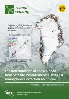
We present a simplified atmospheric correction algorithm for snow/ice albedo retrievals using single view satellite measurements. The validation of the technique is performed using Ocean and Land Colour Instrument (OLCI) on board Copernicus Sentinel-3 satellite and ground spectral or broadband albedo measurements from locations on the Greenland ice sheet and in the French Alps. Through comparison with independent ground observations, the technique is shown to perform accurately in a range of conditions from a 2100 m elevation mid-latitude location in the French Alps to a network of 15 locations across a 2390 m elevation range in seven regions across the Greenland ice sheet. Retrieved broadband albedo is accurate within 5% over a wide (0.5) broadband albedo range of the (N = 4155) Greenland observations and with no apparent bias.View this paper.

Articles (140)

  • Article
  • Open Access
20 Citations
4,043 Views
19 Pages

20 January 2020

In this work, we extended a procedure for the spatial decorrelation of fully-developed speckle, originally developed for single-polarization SAR data, to fully-polarimetric SAR data. The spatial correlation of the noise depends on the tapering window...

  • Article
  • Open Access
40 Citations
5,821 Views
23 Pages

Regional Actual Evapotranspiration Estimation with Land and Meteorological Variables Derived from Multi-Source Satellite Data

  • Bingfang Wu,
  • Weiwei Zhu,
  • Nana Yan,
  • Qiang Xing,
  • Jiaming Xu,
  • Zonghan Ma and
  • Linjiang Wang

20 January 2020

Evapotranspiration (ET) is one of the components in the water cycle and the surface energy balance systems. It is fundamental information for agriculture, water resource management, and climate change research. This study presents a scheme for region...

  • Article
  • Open Access
9 Citations
3,781 Views
15 Pages

20 January 2020

At certain geographic locations, especially in the polar regions, the ionization of the ionospheric E layer can dominate over that of the F2 layer. The associated electron density profiles show their ionization maximum at E layer heights between 80 a...

  • Article
  • Open Access
59 Citations
9,559 Views
15 Pages

Burned Area Detection and Mapping: Intercomparison of Sentinel-1 and Sentinel-2 Based Algorithms over Tropical Africa

  • Mihai A. Tanase,
  • Miguel A. Belenguer-Plomer,
  • Ekhi Roteta,
  • Aitor Bastarrika,
  • James Wheeler,
  • Ángel Fernández-Carrillo,
  • Kevin Tansey,
  • Werner Wiedemann,
  • Peter Navratil and
  • Sandra Lohberger
  • + 2 authors

20 January 2020

This study provides a comparative analysis of two Sentinel-1 and one Sentinel-2 burned area (BA) detection and mapping algorithms over 10 test sites (100 × 100 km) in tropical and sub-tropical Africa. Depending on the site, the burned area was...

  • Article
  • Open Access
10 Citations
5,157 Views
20 Pages

Maintaining Semantic Information across Generic 3D Model Editing Operations

  • Sidan Yao,
  • Xiao Ling,
  • Fiona Nueesch,
  • Gerhard Schrotter,
  • Simon Schubiger,
  • Zheng Fang,
  • Long Ma and
  • Zhen Tian

20 January 2020

Many of today’s data models for 3D applications, such as City Geography Markup Language (CityGML) or Industry Foundation Classes (IFC) encode rich semantic information in addition to the traditional geometry and materials representation. Howeve...

  • Article
  • Open Access
27 Citations
5,773 Views
19 Pages

20 January 2020

Thunderstorms in southeastern South America (SESA) stand out in satellite observations as being among the strongest on Earth in terms of satellite-based convective proxies, such as lightning flash rate per storm, the prevalence for extremely tall, wi...

  • Letter
  • Open Access
112 Citations
8,998 Views
13 Pages

Detection of Maize Tassels from UAV RGB Imagery with Faster R-CNN

  • Yunling Liu,
  • Chaojun Cen,
  • Yingpu Che,
  • Rui Ke,
  • Yan Ma and
  • Yuntao Ma

20 January 2020

Maize tassels play a critical role in plant growth and yield. Extensive RGB images obtained using unmanned aerial vehicle (UAV) and the prevalence of deep learning provide a chance to improve the accuracy of detecting maize tassels. We used images fr...

  • Article
  • Open Access
39 Citations
9,949 Views
28 Pages

20 January 2020

Protection of water environments is an important part of overall environmental protection; hence, many people devote their efforts to monitoring and improving water quality. In this study, a self-adapting selection method of multiple artificial neura...

  • Article
  • Open Access
30 Citations
5,148 Views
19 Pages

20 January 2020

Inshore ship detection plays an important role in many civilian and military applications. The complex land environment and the diversity of target sizes and distributions make it still challenging for us to obtain accurate detection results. In orde...

  • Article
  • Open Access
21 Citations
5,917 Views
33 Pages

20 January 2020

Atmospheric boundary layer height (ABLH) was observed by the CHM15k ceilometer (January 2008 to October 2013) and the PollyXT lidar (July 2013 to December 2018) over the European Aerosol Research LIdar NETwork to Establish an Aerosol Climatology (EAR...

of 14