Topic Editors

Chinese Antarctic Center of Surveying and Mapping, Wuhan University, Wuhan 430079, China
School of Geospatial Engineering and Science, Sun Yat-Sen University, Zhuhai 519082, China
College of Surveying and Geo-Informatics, Tongji University, Shanghai 200092, China
College of Global Change and Earth System Science, Beijing Normal University, Beijing 100875, China
Chinese Antarctic Center of Surveying and Mapping, Wuhan University, Wuhan 430079, China

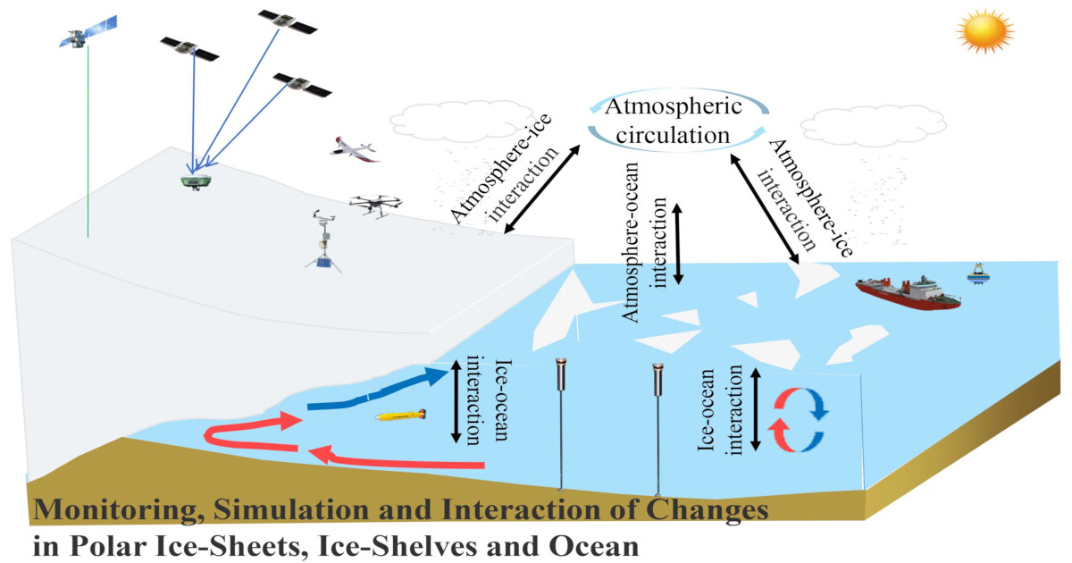
Monitoring, Simulation and interaction of Changes in Polar Ice-Sheets, Ice-Shelves and Ocean

Abstract submission deadline
closed (30 April 2023)
Manuscript submission deadline
closed (31 July 2023)
Viewed by
17359

Topic Information

Dear Colleagues,

The polar regions are very sensitive to climate change and are indicators of the impact of human activities on the global climate. In recent years, rapid ice loss has taken place in the ice sheets and ice shelves, driven by the warming ocean and atmosphere. The entry of a large amount of melt freshwater has brought great changes to the polar ocean. The stability and ice loss of ice sheets/shelves, its contribution to sea level rises, and ice–ocean interactions have always been a focus of wide scientific interest.

A variety of monitoring techniques make it possible to accurately depict the changes in ice sheets/shelves and oceans. The continuous evolution of numerical simulation and ice shelf interaction analysis provides enormous possibilities for an effective tracking and deeper understanding of the response of polar ice sheets/shelves to global climate change. We cordially invite you to contribute by preparing a communication or a full article for this Special Issue, which is dedicated to monitoring, simulating and exploring the changes in polar ice sheet/shelves and the ocean, and their interactions. Relevant themes include but are not limited to the following:

  • Ice sheet elevation changes;
  • Ice sheet mass changes;
  • Surface mass balance over ice sheet;
  • Basal melt of ice shelf;
  • Surface melt ice sheet;
  • Sea-ice thickness changes;
  • Changes in polar ocean temperature, salinity and circulation;
  • Ice–Ocean interaction under the ice shelf.

Prof. Dr. Zemin Wang
Prof. Dr. Fengming Hui
Dr. Gang Qiao
Dr. Yan Liu
Dr. Baojun Zhang
Topic Editors

Keywords

  • antarctic
  • arctic
  • ice sheet
  • ice shelf
  • sea ice
  • polar ocean
  • ice–ocean interaction
  • climate change

Participating Journals

Journal Name Impact Factor CiteScore Launched Year First Decision (median) APC
Atmosphere
atmosphere
2.5 4.6 2010 15.8 Days CHF 2400
ISPRS International Journal of Geo-Information
ijgi
2.8 6.9 2012 36.2 Days CHF 1700
Journal of Marine Science and Engineering
jmse
2.7 4.4 2013 16.9 Days CHF 2600
Remote Sensing
remotesensing
4.2 8.3 2009 24.7 Days CHF 2700
Water
water
3.0 5.8 2009 16.5 Days CHF 2600

Preprints.org is a multidiscipline platform providing preprint service that is dedicated to sharing your research from the start and empowering your research journey.

MDPI Topics is cooperating with Preprints.org and has built a direct connection between MDPI journals and Preprints.org. Authors are encouraged to enjoy the benefits by posting a preprint at Preprints.org prior to publication:

  1. Immediately share your ideas ahead of publication and establish your research priority;
  2. Protect your idea from being stolen with this time-stamped preprint article;
  3. Enhance the exposure and impact of your research;
  4. Receive feedback from your peers in advance;
  5. Have it indexed in Web of Science (Preprint Citation Index), Google Scholar, Crossref, SHARE, PrePubMed, Scilit and Europe PMC.

Published Papers (6 papers)

Order results
Result details
Journals
Select all
Export citation of selected articles as:
26 pages, 8153 KiB  
Article
Geophysics in Antarctic Research: A Bibliometric Analysis
by Yuanyuan Zhang, Changchun Zou, Cheng Peng, Xixi Lan and Hongjie Zhang
Remote Sens. 2023, 15(16), 3928; https://doi.org/10.3390/rs15163928 - 8 Aug 2023
Viewed by 2188
Abstract
Antarctica is of great importance in terms of global warming, the sustainability of resources, and the conservation of biodiversity. However, due to 99.66% of the continent being covered in ice and snow, geological research and geoscientific study in Antarctica face huge challenges. Geophysical [...] Read more.
Antarctica is of great importance in terms of global warming, the sustainability of resources, and the conservation of biodiversity. However, due to 99.66% of the continent being covered in ice and snow, geological research and geoscientific study in Antarctica face huge challenges. Geophysical surveys play a crucial role in enhancing comprehension of the fundamental structure of Antarctica. This study used bibliometric analysis to analyze citation data retrieved from the Web of Science for the period from 1982 to 2022 with geophysical research on Antarctica as the topic. According to the analysis results, the amount of Antarctic geophysical research has been steadily growing over the past four decades as related research countries/regions have become increasingly invested in issues pertaining to global warming and sustainability, and international cooperation is in sight. Moreover, based on keyword clustering and an analysis of highly cited papers, six popular research topics have been identified: Antarctic ice sheet instability and sea level change, Southern Ocean and Sea Ice, tectonic activity of the West Antarctic rift system, the paleocontinental rift and reorganization, magmatism and volcanism, and subglacial lakes and subglacial hydrology. This paper provides a detailed overview of these popular research topics and discusses the applications and advantages of the geophysical methods used in each field. Finally, based on keywords regarding abrupt changes, we identify and examine the thematic evolution of the nexus over three consecutive sub-periods (i.e., 1990–1995, 1996–2005, and 2006–2022). The relevance of using geophysics to support numerous and diverse scientific activities in Antarctica becomes very clear after analyzing this set of scientific publications, as is the importance of using multiple geophysical methods (satellite, airborne, surface, and borehole technology) to revolutionize the acquisition of new data in greater detail from inaccessible or hard-to-reach areas. Many of the advances that they have enabled be seen in the Antarctic terrestrial areas (detailed mapping of the geological structures of West and East Antarctica), ice, and snow (tracking glaciers and sea ice, along with the depth and features of ice sheets). These valuable results help identify potential future research opportunities in the field of Antarctic geophysical research and aid academic professionals in keeping up with recent advances. Full article
Show Figures

Figure 1

16 pages, 3797 KiB  
Article
Estimation of Daily Arctic Winter Sea Ice Thickness from Thermodynamic Parameters Using a Self-Attention Convolutional Neural Network
by Zeyu Liang, Qing Ji, Xiaoping Pang, Pei Fan, Xuedong Yao, Yizhuo Chen, Ying Chen and Zhongnan Yan
Remote Sens. 2023, 15(7), 1887; https://doi.org/10.3390/rs15071887 - 31 Mar 2023
Cited by 1 | Viewed by 1768
Abstract
Thermodynamic parameters play a crucial role in determining polar sea ice thickness (SIT); however, modeling their relationship is difficult due to the complexity of the influencing mechanisms. In this study, we propose a self-attention convolutional neural network (SAC-Net), which aims to model the [...] Read more.
Thermodynamic parameters play a crucial role in determining polar sea ice thickness (SIT); however, modeling their relationship is difficult due to the complexity of the influencing mechanisms. In this study, we propose a self-attention convolutional neural network (SAC-Net), which aims to model the relationship between thermodynamic parameters and SIT more parsimoniously, allowing us to estimate SIT directly from these parameters. SAC-Net uses a fully convolutional network as a baseline model to detect the spatial information of the thermodynamic parameters. Furthermore, a self-attention block is introduced to enhance the correlation among features. SAC-Net was trained on a dataset of SIT observations and thermodynamic data from the 2012–2019 freeze-up period, including surface upward sensible heat flux, surface upward latent heat flux, 2 m temperature, skin temperature, and surface snow temperature. The results show that our neural network model outperforms two thermodynamic-based SIT products in terms of accuracy and can provide reliable estimates of SIT. This study demonstrates the potential of the neural network to provide accurate and automated predictions of Arctic winter SIT from thermodynamic data, and, thus, the network can be used to support decision-making in certain fields, such as polar shipping, environmental protection, and climate science. Full article
Show Figures

Figure 1

25 pages, 74561 KiB  
Article
Interannual Variation of Landfast Ice Using Ascending and Descending Sentinel-1 Images from 2019 to 2021: A Case Study of Cambridge Bay
by Yikai Zhu, Chunxia Zhou, Dongyu Zhu, Tao Wang and Tengfei Zhang
Remote Sens. 2023, 15(5), 1296; https://doi.org/10.3390/rs15051296 - 26 Feb 2023
Cited by 2 | Viewed by 1864
Abstract
Landfast ice has undergone a dramatic decline in recent decades, imposing potential effects on ice travel for coastal populations, habitats for marine biota, and ice use for industries. The mapping of landfast ice deformation and the investigation of corresponding causes of changes are [...] Read more.
Landfast ice has undergone a dramatic decline in recent decades, imposing potential effects on ice travel for coastal populations, habitats for marine biota, and ice use for industries. The mapping of landfast ice deformation and the investigation of corresponding causes of changes are urgent tasks that can provide substantial data to support the maintenance of the stability of the Arctic ecosystem and the development of human activities on ice. This work aims to investigate the time-series deformation characteristics of landfast ice at multi-year scales and the corresponding influence factors. For the landfast ice deformation monitoring technique, we first combined the small baseline subset approach with ascending and descending Sentinel-1 images to obtain the line-of-sight deformations for two flight directions, and then we derived the 2D deformation fields comprising the vertical and horizontal directions for the corresponding periods by introducing a transform model. The vertical deformation results were mostly within the interval [−65, 23] cm, while the horizontal displacement was largely within the range of [−26, 78] cm. Moreover, the magnitude of deformation observed in 2019 was evidently greater than those in 2020 and 2021. In accordance with the available data, we speculate that the westerly wind and eastward-flowing ocean currents are the dominant reasons for the variation in the horizontal direction in Cambridge Bay, while the factors causing spatial differences in the vertical direction are the sea-level tilt and ice growth. For the interannual variation, the leading cause is the difference in sea-level tilt. These results can assist in predicting the future deformation of landfast ice and provide a reference for on-ice activities. Full article
Show Figures

Figure 1

17 pages, 5004 KiB  
Article
Arctic Sea Ice Concentration Assimilation in an Operational Global 1/10° Ocean Forecast System
by Qiuli Shao, Qi Shu, Bin Xiao, Lujun Zhang, Xunqiang Yin and Fangli Qiao
Remote Sens. 2023, 15(5), 1274; https://doi.org/10.3390/rs15051274 - 25 Feb 2023
Viewed by 4532
Abstract
To understand the Arctic environment, which is closely related to sea ice and to reduce potential risks, reliable sea ice forecasts are indispensable. A practical, lightweight yet effective assimilation scheme of sea ice concentration based on Optimal Interpolation is designed and adopted in [...] Read more.
To understand the Arctic environment, which is closely related to sea ice and to reduce potential risks, reliable sea ice forecasts are indispensable. A practical, lightweight yet effective assimilation scheme of sea ice concentration based on Optimal Interpolation is designed and adopted in an operational global 1/10° surface wave-tide-circulation coupled ocean model (FIO-COM10) forecasting system to improve Arctic sea ice forecasting. Twin numerical experiments with and without data assimilation are designed for the simulation of the year 2019, and 5-day real-time forecasts for 2021 are implemented to study the sea ice forecast ability. The results show that the large biases in the simulation and forecast of sea ice concentration are remarkably reduced due to satellite observation uncertainty levels by data assimilation, indicating the high efficiency of the data assimilation scheme. The most significant improvement occurs in the marginal ice zones. The sea surface temperature bias averaged over the marginal ice zones is also reduced by 0.9 °C. Sea ice concentration assimilation has a profound effect on improving forecasting ability. The Root Mean Square Error and Integrated Ice-Edge Error are reduced to the level of the independent satellite observation at least for 24-h forecast, and sea ice forecast by FIO-COM10 has better performance than the persistence forecasts in summer and autumn. Full article
Show Figures

Graphical abstract

18 pages, 5063 KiB  
Article
Reconstruction of Near-Surface Air Temperature over the Greenland Ice Sheet Based on MODIS Data and Machine Learning Approaches
by Jiahang Che, Minghu Ding, Qinglin Zhang, Yetang Wang, Weijun Sun, Yuzhe Wang, Lei Wang and Baojuan Huai
Remote Sens. 2022, 14(22), 5775; https://doi.org/10.3390/rs14225775 - 16 Nov 2022
Cited by 3 | Viewed by 2377
Abstract
High spatial and temporal resolution products of near-surface air temperature (T2m) over the Greenland Ice Sheet (GrIS) are required as baseline information in a variety of research disciplines. Due to the sparse network of in situ data on the GrIS, remote sensing data [...] Read more.
High spatial and temporal resolution products of near-surface air temperature (T2m) over the Greenland Ice Sheet (GrIS) are required as baseline information in a variety of research disciplines. Due to the sparse network of in situ data on the GrIS, remote sensing data and machine learning methods provide great advantages, due to their capacity and accessibility. The Land Surface Temperature (LST) at 780 m resolution from the Moderate Resolution Imaging Spectroradiometer (MODIS) and T2m observation from 25 Automatic Weather Stations (AWSs) are used to establish a relationship over the GrIS by comparing multiple machine learning approaches. Four machine learning methods—neural network (NN), gaussian process regression (GPR), support vector machine (SVM), and random forest (RF)—are used to reconstruct the T2m at daily and monthly scales. We develop a reliable T2m reconstruction model based on key meteorological parameters, such as albedo, wind speed, and specific humidity. The reconstructions daily and monthly products are generated on a 780 m × 780 m spatial grid spanning from 2007 to 2019. When compared with in situ observations, the NN method presents the highest accuracy, with R of 0.96, RMSE of 2.67 °C, and BIAS of −0.36 °C. Similar to the regional climate model (RACMO2.3p2), the reconstructed T2m can better reflect the spatial pattern in term of latitude, longitude, and altitude effects. Full article
Show Figures

Figure 1

16 pages, 8697 KiB  
Article
Long-Term Monitoring and Change Analysis of Pine Island Ice Shelf Based on Multi-Source Satellite Observations during 1973–2020
by Shijie Liu, Shu Su, Yuan Cheng, Xiaohua Tong and Rongxing Li
J. Mar. Sci. Eng. 2022, 10(7), 976; https://doi.org/10.3390/jmse10070976 - 16 Jul 2022
Cited by 4 | Viewed by 2105
Abstract
Pine Island Glacier (PIG) is one of the largest contributors to sea level rise in Antarctica. Continuous thinning and frequent calving imply significant destabilization of Pine Island Glacier Ice Shelf (PIGIS). To understand the mechanism of its accelerated disintegration and its future development, [...] Read more.
Pine Island Glacier (PIG) is one of the largest contributors to sea level rise in Antarctica. Continuous thinning and frequent calving imply significant destabilization of Pine Island Glacier Ice Shelf (PIGIS). To understand the mechanism of its accelerated disintegration and its future development, we conducted a long-term monitoring and comprehensive analysis of PIGIS, including ice flow velocity, ice shelf fronts, ocean water temperature, rifts, and surface strain rates, based on multi-source satellite observations during 1973–2020. The results reveal that: (1) ice flow velocities of PIGIS increased from 2.3 km/yr in 1973 to 4.5 km/yr in 2020, with two rapid acceleration periods of 1995–2009 and 2017–2020, and its change was highly correlated to the ocean water temperature variation. (2) At least 13 calving events occurred during 1973–2020, with four unprecedented successive retreats in 2015, 2017, 2018, and 2020. (3) The acceleration of ice shelf rifting and calving may correlate to the destruction of shear margins, while this damage was likely a response to the warming of bottom seawater. The weakening southern shear margin may continue to recede, indicating that the instability of PIGIS will continue. Full article
Show Figures

Figure 1

Back to TopTop