Skip Content
You are currently on the new version of our website. Access the old version .

Future Transportation

Future Transportation is an international, peer-reviewed, open access journal on the civil engineering, economics, environment and geography, computer science and other transdisciplinary dimensions of transportation published bimonthly online by MDPI.

All Articles (495)

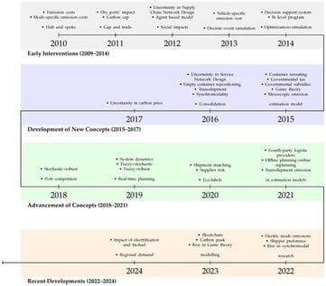
Building upon the methodological synthesis presented in Part I, this second part of our two-part survey examines how operations research (OR) models have been applied to capture the broader dynamics of intermodal transport (IMT) in pursuit of decarbonization. The analysis integrates chronological, modal, and sustainability-oriented perspectives to reveal how IMT strategies evolve across transportation modes, policy environments, and temporal contexts. We identify how efficiency gains, modal shifts, and low-carbon technologies interact within OR frameworks, and assess their implications for emissions reduction, energy use, and network resilience. By bridging technical modeling approaches with system-level sustainability objectives, this study offers a holistic understanding of the pathways through which OR supports the transition toward low-carbon freight systems and highlights research gaps for future interdisciplinary work.

3 February 2026

Evolution of major research themes in OR-driven FT decarbonization, highlighting four dominant phases: Early Interventions (2009–2014), Development of New Concepts (2015–2017), Advancement of Concepts (2018–2021), and Recent Developments (2022–2024). The studies corresponding to each year and theme are summarized in Table A1.

This study investigates left-turn safety at urban intersections using surrogate safety measures derived from field video observations. Time-to-Collision (TTC) among motorized traffic and Post-Encroachment Time (PET) among pedestrian and motorized traffic were extracted for left-turn conflicts across five intersection types in Thessaloniki, Greece, and linked to geometric attributes, signal operations, and traffic conditions. Count-based models (Poisson, Negative Binomial) were estimated alongside machine-learning approaches (Random Forest, Gradient Boosting with Poisson loss). For PET events, the Poisson model had the best balance of parsimony and predictive accuracy, whereas the Negative Binomial model provided a superior fit for TTC events. Results indicate that PET-defined conflicts increased with pedestrian volume and the presence of shared and protected left-turn lanes, and decreased with higher opposing flow, greater average acceleration, and wider end-approach lanes. By contrast, TTC events were associated with lower average speeds, the presence of protected signal phasing for left turns, and the number of passenger cars. Machine-learning models underperformed relative to classical count models, reflecting limited sample size and the discrete event structure. The analysis indicates that the determinants of TTC and PET differ, with certain variables such as pedestrian activity and lane configuration having contrasting effects on the two surrogate safety measures. The analysis reveals that pedestrian demand and shared lane configurations significantly increase PET occurrences, whereas TTC events are more strongly associated with vehicle volumes, speeds, and signal phasing. This distinction underscores the importance of tailoring safety assessment and intervention strategies to the type of interaction being evaluated.

3 February 2026

This research focuses on the challenge of measuring the socio-economic impact of road traffic accidents (RTAs) by examining how losses are redistributed across major institutional sectors, including the government, businesses, and households. Unlike traditional cost-based approaches, the analysis relies on a modified input–output framework that captures not only the direct losses but also the indirect damage flows transmitted from one sector to another. This methodology makes it possible to reveal the multiplicative propagation of losses, determine the proportion of net costs, and quantify the transfer dependencies between institutional agents. Using compiled and adapted data for the Azerbaijani economy, the study estimates the net economic damage from RTAs at 2268.17 million manats after adjusting for internal transfers. The results show that households bear more than 47% of total losses, the enterprise sector accounts for approximately 39%, and the government absorbs nearly 13%. The model also isolates an “additional damage” component, reflecting lost income, profits, and tax revenues, and demonstrates that every 1000 RTA generates a chain reaction of interlinked costs that substantially amplifies the overall effect. The findings highlight the necessity of integrating input–output analytical approaches into the practical assessment of RTA-related economic consequences, particularly in countries with limited statistical capacity and structurally diverse institutional linkages.

3 February 2026

Fishing Ground Identification and Activity Analysis Based on AIS Data

  • Anila Duka,
  • Weiwei Tian and
  • Guoyuan Li
  • + 2 authors

The sustainable management of marine resources requires accurate knowledge of fishing activity patterns and their interaction with coastal infrastructure. Intelligent Transportation Systems (ITS) are increasingly applied in the maritime domain, where data-driven approaches enhance safety, efficiency, and sustainability. In this context, Automatic Identification System (AIS) data provide valuable insights into vessel behavior and fisheries management. This study employs the Density-Based Spatial Clustering of Applications with Noise (DBSCAN) algorithm to identify fishing grounds, and a density map-based approach to recognize port locations. By integrating AIS data with machine learning techniques, the study detects and analyzes fishing vessel activities, providing deeper insights into behaviors such as fishing ground visit times, durations, and transitions between fishing grounds and ports. A case study in the Aalesund area of Norway demonstrates that DBSCAN effectively reveals fishing activity patterns relevant to regulatory oversight and spatial planning, while density mapping accurately identifies fishing ports. The findings highlight the potential of AIS-based analytics and clustering methods within maritime ITS frameworks to enhance situational awareness, support compliance with fisheries regulations, and contribute to sustainable marine resource management. Using 2023 AIS data from the Aalesund region, 6 recurrent fishing grounds and 15 port locations are identified, and size-stratified visit frequency and residence-time distributions are quantified together with monthly seasonality in ground usage.

2 February 2026

News & Conferences

Issues

Open for Submission

Editor's Choice

Get Alerted

Add your email address to receive forthcoming issues of this journal.

XFacebookLinkedIn
Future Transp. - ISSN 2673-7590