Abstract
The increasing frequency of extreme wildfire behavior globally, particularly under the influence of anthropogenic climate change, poses unprecedented challenges to traditional fire management paradigms. This study presents a comprehensive, multi-dimensional case study of the catastrophic eruptive fire event that occurred in Xintian County, Hunan Province, China, on 17 October 2022. By integrating data on long-term ecological drought, critical synoptic-scale weather conditions, and real-time emission profiles of combustion products, we delineate the mechanistic chain leading to eruptive fire development in a subtropical evergreen broad-leaved forest region, historically considered a low-to-moderate fire risk zone. Our results demonstrate that the eruptive fire was a consequence of a critical convergence of factors: a protracted pre-conditioning drought that significantly reduced live and dead fuel moisture, a specific meteorological window characterized by extremely low relative humidity (<60%) and initially high wind speeds (peak at 16.5–17.9 m/s), and the abundant production and accumulation of flammable pyrolysis gases (e.g., CO, CH4) from the dominant Masson pine forests. The emission data pinpointed October 19th as the key tipping point, marking the transition to high-intensity combustion. This study underscores the vulnerability of subtropical forest ecosystems to eruptive fires during compound extreme events. Our findings provide a critical scientific basis for updating fire danger rating systems and early warning strategies in similar ecological regions under a changing climate.
1. Introduction
Global wildfire activity is undergoing a profound paradigm shift [1]. Driven by anthropogenic climate change, alterations in the fundamental drivers of wildfire—fuel availability, ignitions, and fire weather—are collectively modifying wildfire regimes globally [2]. This influence has extended beyond fire-prone regions like the Mediterranean and boreal forests, manifesting as prolonged fire seasons, expanded burned areas, and a surge in extreme fire behavior events [3]. Extreme behaviors such as eruptive fires, characterized by exceptionally high energy release rates, rapid spread speeds, and nonlinear and rapidly evolving behavior [4], often exceed the limits of existing suppression methods, posing the most severe threats to ecosystems and socio-economic systems. This global trend necessitates a critical re-evaluation of wildfire risk, even in regions historically perceived as low-risk, such as humid subtropical forests [5].
Wildfire occurrence is conventionally conceptualized through the “fire behavior triangle” framework, requiring the simultaneous presence of fuel, ignition sources, and favorable weather conditions. Recent scholarly focus has increasingly shifted toward a “compound disaster” paradigm, emphasizing how synergistic effects of multiple stressors (e.g., prolonged drought, heatwaves, and strong winds) can precipitate nonlinear escalations in fire risk [1,3]. Particularly in ecosystems traditionally considered low-risk due to humid climates, understanding how these factors breach ecological “resilience thresholds” to trigger extreme fire behavior has emerged as a research frontier [5].
The subtropical evergreen broad-leaved forest region south of the Yangtze River in China has traditionally been classified as a low-to-moderate fire risk zone, attributed to its relatively humid climate and predominantly less-flammable vegetation types [6]. However, localized effects of global change are challenging this conventional understanding [7]. Persistent extreme drought events can drastically alter fuel conditions in this region: severe moisture deficit in live vegetation and extremely low moisture content in litter layer can rapidly transform these previously less-flammable ecosystems into high-risk “superfuel” [8]. This transformation process, whereby ecological drought significantly enhances flammability through moisture reduction in both live and dead fuels, has been empirically observed and verified across diverse global ecosystems, including Mediterranean shrublands and boreal forests [2,8]. Despite this escalating risk, systematic scientific research on extreme fire behavior in this region, particularly eruptive fires coupled with complex hilly terrain, remains relatively scarce [9]. Existing fire management models and suppression tactics, largely based on experiences from temperate and Mediterranean forests or grassland fires, may be inadequate for addressing these novel, high-energy fires resulting from the interaction of subtropical hilly topography and extreme drought [10]. Consequently, there is a pressing need to enhance regional disaster prevention and mitigation capabilities [11].
Within this conceptual framework, our study focused on three interconnected causal factors: prolonged ecological drought, specific critical meteorological windows, and pyrolytic gas production from combustible materials. These factors were selected because they collectively constitute a complete causal chain from gradual environmental stress accumulation to sudden disaster manifestation. Long-term drought establishes the energy foundation, specific meteorological conditions act as triggering mechanisms, while the production and accumulation of pyrolytic gases represent the direct physico-chemical processes enabling eruptive fire development. This analytical framework aims to elucidate the unique mechanistic pathway of eruptive fire formation within the specific context of subtropical hilly terrain.
The “10·17” forest fire that occurred in Xintian County, Yongzhou City, Hunan Province, China in October 2022 (Figure 1) is a typical case of extreme fire behavior emerging from the interplay of the aforementioned global context and regional issues [12]. A typical eruptive fire event occurred during this incident, causing tragic firefighter casualties. This tragic event exposed the limitations of the current response capabilities and also provided a critical case for scientific investigation.
Figure 1.
Geographical context of the study area for the 2022 “10·17” forest fire in Xintian County, Hunan Province, China. (a) Location, (b) vegetation type distribution, (c) digital elevation model (DEM), (d) slope, (e) aspect, (f) topographic relief, and (g,h) fire scene map.
Therefore, this study employed a multidimensional, data-driven case study framework to dissect the causal mechanisms of this eruptive fire [13]. The research will sequentially clarify the geographical, fuel, and topographic context of the fire occurrence, trace the meteorological drivers during key development phases, identify the critical meteorological conditions during the eruptive fire event, validate the energy release characteristics of extreme fire behavior through emission data, spatially assess the coupling relationship of multiple disaster-inducing indicators, and temporally diagnose the accumulation and critical state of pre-fire environmental stressors. Through analyzing this complete chain, this study not only seeks to reveal the unique mechanisms behind eruptive fire formation in subtropical hilly areas but also aims to provide a solid scientific basis for optimizing wildfire risk management, early warning, forecasting, and emergency response strategies in China and similar ecological regions globally.
2. Study Area and Methodology
2.1. Study Area
This study focused on Xintian County, Yongzhou City, Hunan Province, China. The area is situated on the northern edge of the Nanling hilly ecological zone and falls within a typical subtropical monsoon climate zone, with a mean annual temperature of 18.1 °C and mean annual precipitation of 1425 mm [14]. During the summer and autumn of 2022, the region experienced its most severe seasonal drought on record. Precipitation from July to October was 68% lower than the multi-year average for the same period, accompanied by 45 consecutive days without effective rainfall, leading to the soil relative humidity dropping below 30% and creating an extreme drought background.
The topography of Xintian County is predominantly characterized by hills and valleys, with elevations ranging between 150 and 650 m and slopes mostly between 15° and 35° (Figure 1) [12]. Widespread typical V-shaped valleys and enclosed basin landforms significantly influence local circulation patterns, readily inducing valley wind effects and acting as natural channels for concentrating hot air currents and smoke during fire events.
Xintian County has a forest coverage rate of 62.3%, with a total forest land area exceeding 58,000 hectares. It is classified as a Grade I (represents the highest level of wildfire risk) wildfire risk county unit according to the National Forest Fire Risk Zonation Classification. The spatial distribution pattern within the county features interwoven forest areas, settlements, and farmland. Frequent human activity further increases the difficulty of ignition source management and the overall wildfire risk.
The forest vegetation in Xintian County is dominated by monoculture plantations of Pinus massoniana, accounting for 71.2% of the total forest area. The needles of this species are rich in volatile oils (with an average oil content of 3.8%), and the litter layer accumulates to a thickness of 10–15 cm. Furthermore, the forest stand structure exhibits a typical “vertical continuity”—meaning that the surface litter, middle shrub layer, and upper tree canopy form a complete vertical fuel ladder (Figure 1).
This specific fuel configuration creates an ideal combustible environment for eruptive fire occurrence: the dense needle litter provides a sustained smoldering matrix, dry shrubs form a ladder for vertical fire development, and the oil-rich canopy acts as a significant source of gaseous combustibles. Combined with the complex local terrain and the extreme climatic background of 2022, Xintian County presents a highly representative natural laboratory for studying the formation mechanisms of forest eruptive fires in subtropical hilly areas [15].
2.2. Data and Methodology
This study was designed to systematically deconstruct the causative mechanisms of the Xintian eruptive fire by addressing three sequential research questions: (1) What were the long-term environmental preconditions? (2) What were the critical real-time meteorological drivers? (3) How did fire behavior and energy release evolve? To answer these, a multi-method approach was employed. Long-term ecological drought was quantified using the Vegetation Health Index (VHI) and its components—the Vegetation Condition Index (VCI) and Temperature Condition Index (TCI)—derived from MODIS data, as these indices are specifically designed to monitor vegetation moisture and thermal stress. Critical fire weather conditions were analyzed using high-resolution ECMWF ERAS reanalysis data, chosen for its spatial completeness over complex terrain. The evolution of fire behavior and intensity was inferred from the daily emission data of combustion products (e.g., CO, CH4) from the GFED5 database, which serves as a robust proxy for fire energy release. A case–control design was then applied to statistically identify the meteorological parameters most significantly associated with the eruptive fire event [13]. The date 21 October 2022, the day the eruptive fire event occurred, was designated as the case period, while the four days preceding the event (17–20 October) served as the control period. This allowed for a systematic comparison of differences in key meteorological parameters between the two periods. Given that the meteorological data might not follow a normal distribution, the Mann–Whitney U test (also known as the Wilcoxon rank-sum test) was used to compare the distribution of each meteorological parameter between the two groups [16].
Hourly meteorological data for the fire period (17–26 October 2022) were obtained from the ECMWF ERAS reanalysis dataset (specifically, the reanalysis-era5-single-levels-timeseries product). The variables extracted included 2 m air temperature, 2 m dew point temperature, 10 m U and V wind components, and total precipitation for a grid point centered on the fire zone (approximately 25.9° N, 112.2° E). The native spatial resolution of the dataset was 0.25° × 0.25°. Post-download, relative humidity was calculated from the 2 m temperature and dew point temperature using standard psychrometric equations. Wind speed and direction were derived from the U and V wind components. This gridded reanalysis product was selected for its spatial consistency and completeness, which is critical for analyzing regional fire weather patterns.
The Vegetation Health Index (VHI) and its components, the Vegetation Condition Index (VCI) and Temperature Condition Index (TCI), were derived from Moderate Resolution Imaging Spectroradiometer (MODIS) data products. The Normalized Difference Vegetation Index (NDVI) was sourced from the MOD13 product (MOD13A2 Version 6.1), which provides 16-day composite data at a 1 km spatial resolution. The Land Surface Temperature (LST) data, used as a proxy for Brightness Temperature (BT), were sourced from the MOD11 product (MOD11A2 Version 6.1), which provides 8-day composites at a 1 km resolution. To construct a continuous weekly time series for the year 2022, the 8-day LST data were linearly interpolated to match the 16-day NDVI timestamps before index calculation. The VCI and TCI were computed using Equations (1) and (2), respectively, based on the historical range of NDVI and BT values for the same calendar week from 2012 to 2021. The final VHI was calculated as an equally weighted combination (α = 0.5) of VCI and TCI, following the established methodology [17,18]. The VHI and TCI indices range from 0 to 100, where lower values indicate greater vegetation stress (drought or thermal). Following the established classification [17,18], VHI/TCI values below 40 signify drought stress, and values below 15 represent extreme conditions.
Data on fire emissions, including dry matter (DM) consumption, carbon dioxide (CO2), carbon monoxide (CO), methane (CH4), organic carbon (OC), and black carbon (BC), were obtained from the Global Fire Emissions Database, Version 5 (GFED5) Beta daily dataset (specifically, the GFED5_Beta_daily_202210 file). This dataset provides global daily emissions estimates at a spatial resolution of 0.25 degrees. The emissions are estimated by combining satellite-derived observations of burned area and fire radiative power (FRP) with a biogeochemical model to simulate fuel consumption and subsequent emissions. For this study, daily emission estimates for the core fire period (17–26 October 2022) were extracted for the specific grid cell encompassing the Xintian fire event to analyze the temporal dynamics of combustion intensity.
Vegetation Condition Index (VCI): This index assesses the relative health of vegetation by comparing the current Normalized Difference Vegetation Index (NDVI) to its long-term historical maximum and minimum values for the same period.
VCI = (Current NDVI − NDVI_min)/(NDVI_max − NDVI_min) × 100
Temperature Condition Index (TCI): Following a similar logic to VCI but using brightness temperature (BT), this index compares the current thermal condition to the long-term historical record and is used to monitor thermal stress.
TCI = (BT_max − Current BT)/(BT_max − BT_min) × 100
Vegetation Health Index (VHI): VHI = α × VCI + (1 − α) × TCI (where α is typically 0.5, indicating equal weighting).
The fire risk assessment conducted by the Center for Satellite Applications and Research adheres to internationally accepted disaster risk models, defining wildfire risk as a function of three core components: Wildfire Risk = f (Hazard × Exposure × Vulnerability). For this case study, Hazard was represented by fuel conditions (VHI/TCI) and ignition sources (human activity); Exposure was derived from land cover data identifying settlements and infrastructure; and Vulnerability was inferred from vegetation type and topographic accessibility.
Hazard refers to the potential likelihood of wildfire ignition and spread, jointly determined by fuel conditions and ignition source availability. Exposure denotes the spatial distribution of valuable assets such as population, infrastructure, and farmland within a specific wildfire risk area. Vulnerability indicates the susceptibility of elements at risk to suffer damage from wildfire and their lack of capacity to cope and respond.
3. Results
3.1. Meteorological Conditions
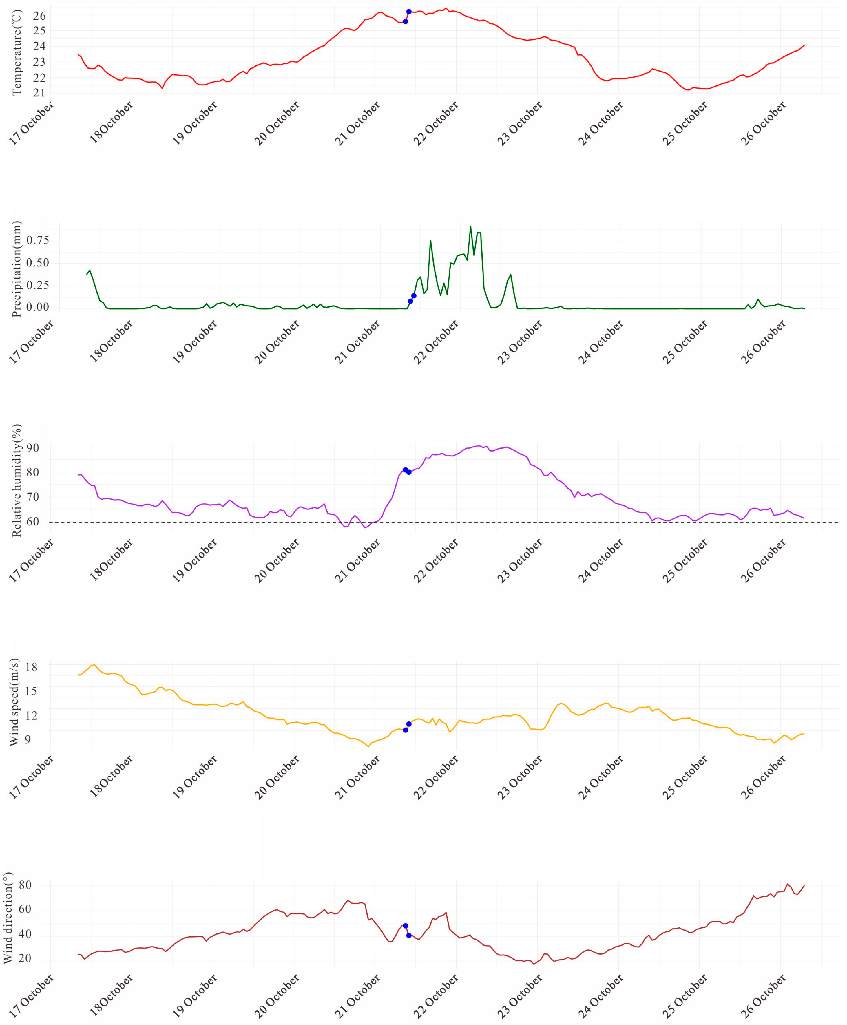
A quantitative analysis of key meteorological elements influencing fire danger ratings was conducted for the period from 17 October to 26 October 2022 during the wildfire event in Xintian County, Hunan Province, China. The results demonstrate that hourly precipitation remained at negligible levels throughout the observation period (mostly <0.001 mm/h). This persistent, near-zero precipitation state significantly reduced the moisture content of surface fuels, creating an extremely dry environmental background and providing the fundamental prerequisite for both fire ignition and spread (Figure 2).
Figure 2.
Temporal series of meteorological parameters during the critical development period of the “10·17” forest fire in Xintian County, Hunan Province, China, 2022. The dashed horizontal line on the relative humidity panel in Figure 2 indicates the 60% critical threshold.
Air temperature exhibited minor fluctuations during the observational period, generally ranging between 21 °C and 26 °C. Relative humidity (RH), which is critically important for fire behavior, displayed distinct diurnal and phased characteristics. During the initial phase of the fire (17–18 October), daytime RH was approximately 63–65%, recovering during nighttime hours. From 20 October onwards, the minimum daytime humidity decreased further, repeatedly dropping below 60% (e.g., reaching 58.0% at 15:00 on 20 October, and remaining between 61.7–61.8% from 12:00 to 13:00 on 21 October) (Figure 2).
The peak wind speeds of the observation period occurred during the initial fire development phase (17 October), with daytime average wind speeds reaching 16.5–17.9 m/s. Winds of this magnitude dramatically accelerated fire front progression and significantly complicated suppression efforts (Figure 2). Although wind speeds showed a general decreasing trend in the subsequent days (declining to approximately 7–8 m/s by 25–26 October), the high wind event during the initial phase played a decisive role in the rapid expansion of the fire. Wind direction exhibited minor variations throughout the observation period, indicating a relatively stable, dominant flow direction.
Wilcoxon rank-sum test results revealed statistically significant differences among the various meteorological variables, providing important insights into the fire weather conditions (Figure 3). Both air temperature and relative humidity showed highly statistically significant variations (p < 0.001), indicating substantial fluctuations in these fundamental fire weather factors during the monitoring period. The p-value for relative humidity is particularly noteworthy, as this parameter directly influences the fuel moisture content and ignition probability (Figure 3). Similarly, wind speed also showed significant variation (p = 0.0034), reflecting dynamic atmospheric conditions likely influencing fire spread behavior and intensity (Figure 3). In contrast, wind direction exhibited a non-significant statistical pattern (p = 0.8107), confirming the relative stability of the predominant airflow direction throughout the observation period (Figure 3).
Figure 3.
Identification of critical meteorological conditions on the day of the eruptive fire (21 October) in Xintian County, Hunan Province, China. Statistical significance between the case and control periods is indicated by asterisks (** for p < 0.01; ns for not significant).
3.2. Flammable Gas and Dry Matter Conditions
Emission monitoring data revealed a highly episodic pattern of combustion activity throughout October 2022, with a critical developmental phase preceding the major eruptive fire event. A significant emission pulse was detected on 19 October, characterized by substantial releases of multiple pollutants. Dry matter (DM) consumption reached 3.89 tons, accompanied by emissions of 6.23 tons of CO2, 0.29 tons of CO, and 0.012 tons of CH4 (Figure 4). This pulse was identified as a crucial precursor event, marking the transition from an initial phase with minimal emissions (recorded as zero during 17–18 October) to a period of intensified, high-energy combustion.
Figure 4.
Dynamics of fire emissions during the “10·17” forest fire event in Xintian County, Hunan Province, China.
The synchronous peaks in both complete (CO2) and incomplete (CO, CH4) combustion products, along with significant particulate carbon emissions (OC: 0.025 tons; BC: 0.0016 tons), characterize a combustion regime dominated by inefficient, smoldering processes (Figure 4). This particular combustion pattern is highly effective in generating pyrolytic gases, which likely accumulated within the fire environment. By 19 October, the fire had developed sufficient energy intensity to produce substantial quantities of flammable gaseous fuels, thereby establishing potential preconditions for the subsequent eruptive fire event.
3.3. Vegetation Conditions
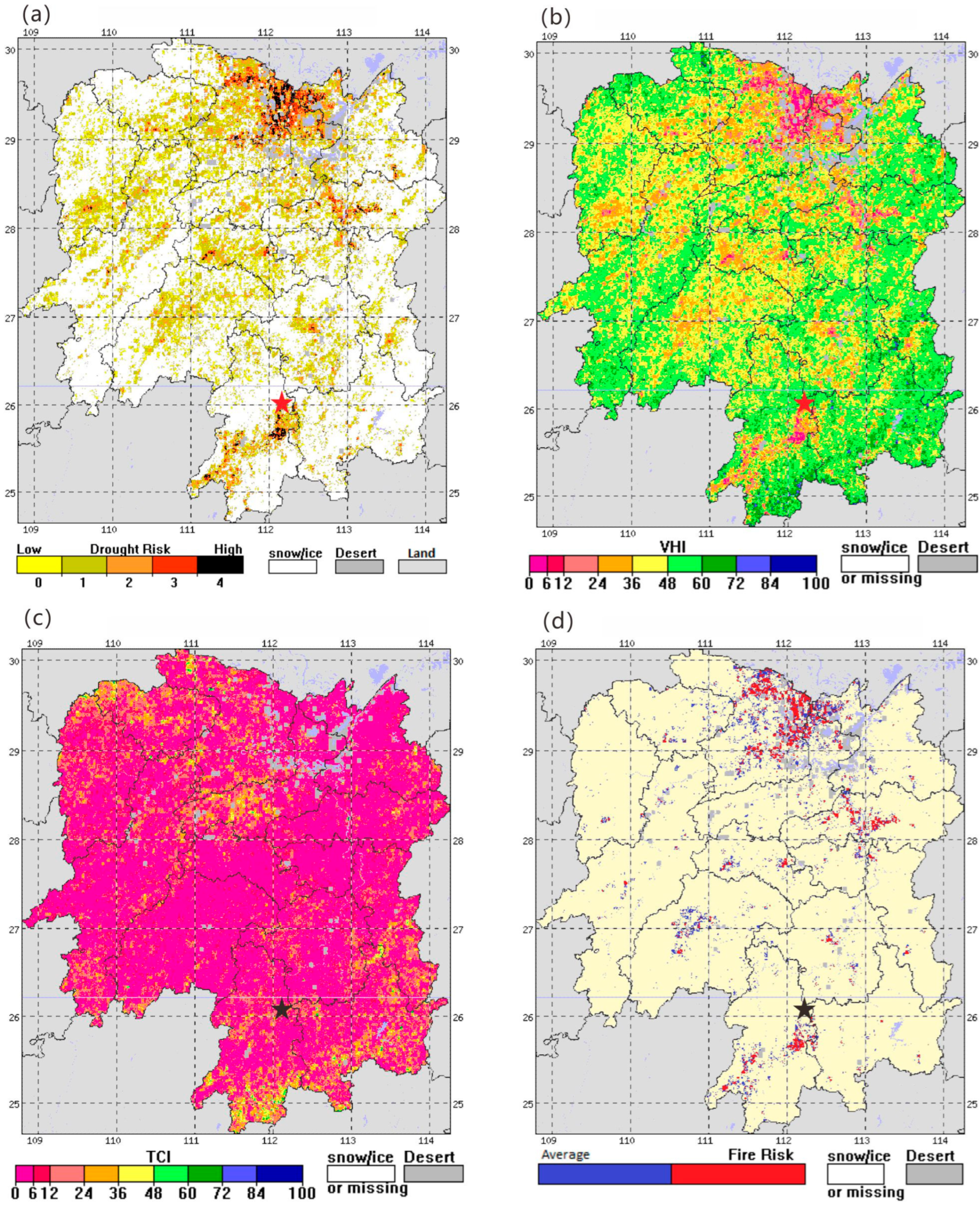
Data analysis revealed a significant and sustained environmental preconditioning phase prior to the eruptive fire event. The Temperature Condition Index (TCI) showed a sharp decline starting around Week 10, reaching its annual minimum of 6.25 in Week 42 (mid-October) (Figure 5 and Figure 6). This extreme thermal stress event was not isolated but part of a prolonged process, with TCI values remaining below 20 from Week 31 through to Week 47 (Figure 5 and Figure 6). Concurrently, the spatial extent of drought conditions expanded dramatically. The area affected by extreme drought according to TCI peaked at 84.72% in Week 42, while exceptional drought coverage reached a remarkable 62.52% (Figure 5 and Figure 6). This indicates that during the weeks preceding the fire, the vast majority of the region experienced extreme thermal stress and moisture deficit, creating a critically receptive fuel environment. The eruptive fire event occurred when the TCI reached an extreme low of 6.25. However, for early warning applications, the critical state was defined not only by this absolute minimum but by the prolonged period of TCI values remaining below 20, coupled with a dramatic expansion of the spatial extent of areas under ‘Extreme’ (TCI < 15) and ‘Exceptional’ (TCI < 10) drought. A two-tiered warning system, considering both the absolute TCI value and its spatial distribution, is therefore recommended for proactive fire management.
Figure 5.
Integrated assessment of the causative environment for the eruptive fire based on multi-source indices. (a) Drought Risk, (b) VHI, (c) TCI, (d) Fire Risk. VHI and TCI values range from 0 (extreme stress) to 100 (optimal condition), with values below 40 indicating drought stress and values below 15 signifying extreme thermal/drought conditions.
Figure 6.
The pre-fire environmental critical state: escalating thermal stress and drought extent before the Xintian fire. VHI and TCI values range from 0 (extreme stress) to 100 (optimal condition), with values below 40 indicating drought stress and values below 15 signifying extreme thermal/drought conditions.
The Vegetation Health Index (VHI), which reflects the integrated response of vegetation to both moisture and thermal stress, exhibited a more gradual yet persistent declining trend throughout the year, reaching its lowest value (41.62) in Week 47 (Figure 5 and Figure 6). Although the absolute VHI values and the percentage areas classified under VHI-based drought were generally lower than those derived from TCI, a continuous and significant expansion of moderate and severe drought areas based on VHI was observed from Week 34 onward. The area under moderate VHI-drought peaked at 25.66% in Week 47 (Figure 5 and Figure 6). This discrepancy between the TCI and VHI indicators suggests that while atmospheric aridity was extreme, vegetation underwent a cumulative stress response, with its health progressively deteriorating and crossing critical thresholds in the weeks before the fire, thereby increasing its flammability.
The eruptive fire event on 21 October occurred within the context of the most severe environmental stress observed throughout the year. Week 42 represented the annual nadir for TCI and the peak for TCI-based extreme/exceptional drought extent. The VHI for this week was 44.7, firmly within the range indicating significant vegetation stress. The convergence of these indicators during this specific period delineated a critical window for fire weather and fuel conditions. Due to the synergistic effects of extreme thermal stress, widespread extreme drought, and severely compromised vegetation health, the regional landscape became primed for the occurrence of high-intensity fire behavior.
4. Discussion
This study demonstrates that the eruptive fire event resulted from the synergistic interaction of prolonged drought stress, specific meteorological conditions, and critical fuel states [2]. Vegetation monitoring data indicate the study area experienced sustained ecological drought before the fire. The Temperature Condition Index (TCI) remained below 20 from Week 31 to 47, reaching an extreme low of 6.25 in Week 42, while extreme and exceptional drought coverage peaked at 84.72% and 62.52%, respectively [17]. The Vegetation Health Index (VHI) showed a continuous decline from 56.91 to 41.62 by Week 47, confirming persistent vegetation moisture stress [18]. This prolonged drought background significantly reduced the moisture content in both live and dead fuels, accumulating substantial potential energy for high-intensity fire behavior [4]. Our observation that a prolonged drought (TCI < 20 for over 17 weeks) preconditioned the landscape aligns with global studies on the ‘energy release component’ and fuel aridity in other forest systems [4,19]. However, the sensitivity of these humid subtropical Masson pine forests to such drought, transforming them into a high-risk ‘superfuel’, may be greater than previously recognized [6,8].
Real-time meteorological observations during the fire period revealed that a critical configuration was established: relative humidity repeatedly falling below 60%, coinciding with the legacy of a rapidly expanded fire front from initial wind speeds exceeding 16.5 m/s. This synergy, under stable wind direction, constituted the decisive meteorological trigger [20]. Statistical tests confirmed significant variations in temperature, humidity, and wind speed (p < 0.01), while wind direction stability (p = 0.8107) ensured directional energy accumulation in the fire zone [4]. These factors acted synergistically to dramatically enhance both the fire spread rates and combustion efficiency [21]. The identified critical RH threshold (<60%), while consistent with the fire danger literature [20], proved particularly potent in this context due to the pre-dried fuels. The initial high-wind event (16.5–17.9 m/s) was crucial not merely for spread, but for rapidly creating a large burn area that subsequently acted as a massive heat source, enhancing local pyro-convective processes and the production of flammable gases—a positive feedback loop less commonly documented in subtropical hills [10,21].
Emission monitoring data identified October 19 as a crucial tipping point, with simultaneous peaks in dry matter consumption (3.89 tons) and flammable gases (CO: 0.29 tons; CH4: 0.012 tons). These pyrolytically derived gases accumulated at the fire front, forming explosive mixtures [22]. When encountering adequate oxygen supply and turbulent conditions, these mixtures underwent flashover, leading to rapid fire intensity escalation and completing the transition from conventional combustion to eruptive fire behavior [10]. The subsequently observed higher emission peaks (22–23 October) confirm the persistence of this positive feedback mechanism [1].
While the specific fuel matrix of Masson pine litter is unique to this region, the mechanistic chain of fuel preconditioning by drought leading to increased flammability aligns with observations from other forest types. For instance, similar TCI-driven fuel aridification has been linked to increased fire intensity in Mediterranean pine forests [8,22]. However, the rapidity of the transition to eruptive behavior in this case, facilitated by the combination of complex topography and the specific fuel ladder of Masson pine, appears distinct from the more gradual build-up sometimes observed in coniferous forests of the western United States [10,21]. This underscores that while the fundamental physics of eruptive fires are universal, their manifestation is critically dependent on regional ecological and topographic contexts.
The reliance on reanalysis and 1 km resolution remote sensing data, while suitable for regional analysis, may not capture micro-topographic and micro-climatic extremes that influence hyper-local fire behavior. Furthermore, the emission data, while indicative of combustion efficiency, are model-derived estimates. Future research should incorporate high-resolution computational fluid dynamics (CFD) fire-atmosphere modeling to explicitly simulate the interaction between terrain, wind fields, and fire-induced flows in such complex terrain. Additionally, a systematic comparison with other eruptive fire events in humid regions is needed to validate the proposed critical thresholds more broadly.
5. Conclusions
This study, through multi-source data fusion analysis, systematically revealed the formation mechanism of the eruptive fire event in the subtropical hilly forest area of Xintian County, Hunan Province, China, in 2022. The main conclusions are as follows:
1. The prolonged drought background served as the energy foundation for the eruptive fire. Extreme ecological drought persisting for months prior to the fire event (with TCI dropping to a minimum of 6.25 and extreme drought coverage exceeding 80%) reduced the moisture content of both live and dead fuels to critical levels. This transformed the entire ecosystem into a high-risk “superfuel”, accumulating the necessary potential energy for the eruptive fire.
2. A specific meteorological configuration constituted the critical triggering condition for the eruptive fire. During fire development, synergistically low relative humidity (repeatedly below 60%) and initially high wind speeds created an environment conducive to efficient combustion and rapid spread. Concurrently, stable wind direction ensured the directional accumulation and release of energy within the fire zone, forming the decisive meteorological critical condition for the eruptive fire occurrence.
3. The substantial production and accumulation of flammable gases was the direct inducement for the eruptive fire. Emission data clearly identified October 19 as the tipping point in fire behavior. The significant simultaneous peaks in dry matter and flammable gas emissions (CO, CH4) confirmed the accumulation of pyrolytically derived gaseous fuels at the fire front. Ultimately, under specific conditions, this led to a flashover, completing the fundamental transition from conventional combustion to eruptive fire behavior.
The mechanistic understanding derived from this study has direct implications for fire management. Firstly, fire danger rating systems in humid subtropical regions should incorporate pre-conditioning ecological drought indices (like VHI and TCI) to better capture long-term fuel drying. Secondly, real-time monitoring of specific meteorological thresholds (e.g., RH < 60% coupled with high wind speeds) can enhance early warning precision for potential eruptive fire events. Finally, firefighting tactics and evacuation planning must account for the potential for rapid fire behavior transitions driven by pyrolytic gas accumulation, especially in complex terrains with continuous fuel layers like Masson pine forests.
Author Contributions
Conceptualization, D.W.; methodology, D.W.; software, M.B.; validation, S.Y.; formal analysis, D.W.; investigation, S.Y.; resources, M.B.; data curation, D.W.; writing—original draft preparation, M.B. and D.W.; writing—review and editing, S.Y.; visualization, M.B.; supervision, S.Y.; project administration, D.W.; funding acquisition, S.Y. All authors have read and agreed to the published version of the manuscript.
Funding
This work was supported by a research grant from the National Institute of Natural Hazards, Ministry of Emergency Management of China (ZDJ2024-27).
Institutional Review Board Statement
Not applicable.
Informed Consent Statement
Not applicable.
Data Availability Statement
Data are contained within the article.
Acknowledgments
We would like to thank the editor and anonymous reviewers for their valuable comments and suggestions to this paper.
Conflicts of Interest
The authors declare no conflicts of interest.
References
- Bowman, D.M.; Kolden, C.A.; Abatzoglou, J.T.; Johnston, F.H.; van der Werf, G.R.; Flannigan, M. Vegetation fires in the Anthropocene. Nat. Rev. Earth Environ. 2020, 1, 516–529. [Google Scholar] [CrossRef]
- Jolly, W.M.; Cochrane, M.A.; Freeborn, P.H.; Holden, Z.A.; Brown, T.J.; Williamson, G.J.; Bowman, D.M.J.S. Climate-induced variations in global wildfire danger from 1979 to 2013. Nat. Commun. 2015, 6, 7537. [Google Scholar] [CrossRef] [PubMed]
- Flannigan, M.D.; Krawchuk, M.A.; de Groot, W.J.; Wotton, B.M.; Gowman, L.M. Implications of changing climate for global wildland fire. Int. J. Wildland Fire 2009, 18, 483–507. [Google Scholar] [CrossRef]
- Tedim, F.; Leone, V.; Amraoui, M.; Bouillon, C.; Coughlan, M.R.; Delogu, G.M.; Fernandes, P.M.; Ferreira, C.; McCaffrey, S.; McGee, T.K.; et al. Defining extreme wildfire events: Difficulties, challenges, and impacts. Fire 2018, 1, 9. [Google Scholar] [CrossRef]
- Liu, Z.; Yang, J.; Chang, Y.; Weisberg, P.J.; He, H.S. Spatial patterns and drivers of fire occurrence and its future trend under climate change in a boreal forest of Northeast China. Glob. Change Biol. 2012, 18, 2041–2056. [Google Scholar] [CrossRef]
- Zhang, Y.; Li, X.; Kong, Z.; Du, N.; Wu, M. Subtropical forest vegetation development and climate change in Baishanzu area of Zhejiang Province, China, since the Holocene. Palaeogeogr. Palaeoclimatol. Palaeoecol. 2022, 608, 111293. [Google Scholar] [CrossRef]
- Ding, J.; Yang, T.; Zhao, Y.; Liu, D.; Wang, X.; Yao, Y.; Peng, S.; Wang, T.; Piao, S. Increasingly important role of atmospheric aridity on Tibetan Alpine grasslands. Geophys. Res. Lett. 2018, 45, 2852–2859. [Google Scholar] [CrossRef]
- Keeley, J.E.; Bond, W.J.; Bradstock, R.A.; Pausas, J.G.; Rundel, P.W. Fire in Mediterranean Ecosystems: Ecology, Evolution and Management; Cambridge University Press: Cambridge, UK, 2012. [Google Scholar]
- Duane, A.; Castellnou, M.; Brotons, L. Towards a comprehensive look at global drivers of novel extreme wildfire events. Clim. Change 2021, 165, 43. [Google Scholar] [CrossRef]
- Sullivan, A.L. A review of wildland fire spread modelling, 1990–present, 1: Physical and quasi-physical models. Prog. Phys. Geogr. 2009, 33, 654–684. [Google Scholar]
- Wang, X.; Thompson, D.K.; Marshall, G.A.; Tymstra, C.; Carr, R.; Flannigan, M.D. Increasing frequency of extreme fire weather in Canada with climate change. Clim. Change 2015, 130, 573–586. [Google Scholar] [CrossRef]
- Hu, H.; Deng, X.; Zhang, G.; Feng, L.; Long, J.; Li, Z.; Zhu, Y.; Wang, Y. Fire Behavior Simulation of Xintian Forest Fire in 2022 Using WRF-Fire Model. Front. For. Glob. Change 2024, 7, 1336716. [Google Scholar] [CrossRef]
- Bhowmik, S.; Hajra, A. Case Control Study: Design, Measures, and Classic Examples. In Handbook for Designing and Conducting Clinical and Translational Research; Eltorai, A.E.M., Bakal, J.A., Gibson, C.M., Eds.; Academic Press: Cambridge, MA, USA, 2025; pp. 211–216. [Google Scholar]
- Liu, J.; He, Z.; Shi, H.; Zhao, Y.; Wang, J.; Liu, A.; Li, L.; Zhu, R. The Analysis of Spatiotemporal Changes in Vegetation Coverage and Driving Factors in the Historically Affected Manganese Mining Areas of Yongzhou City, Hunan Province. Land 2025, 14, 133. [Google Scholar] [CrossRef]
- Yang, Y.; Tang, J.; Chen, H.; Huang, J.; Chen, L.; Wang, X.; Wang, Q.; Zhao, E. Analysis of Meteorological Conditions of Forest Fires in Hunan Under the Background of Extreme Drought in 2022: A Case Study of the “10.17” Major Forest Fire in Xintian. J. Catastrophology 2024, 39, 113–118. [Google Scholar]
- Rousseaux, C.G.; Gad, S.C. (Eds.) Haschek and Rousseaux’s Handbook of Toxicologic Pathology, 3rd ed.; Academic Press: Boston, MA, USA, 2013. [Google Scholar]
- Zeng, J.; Zhang, R.; Qu, Y.; Bento, V.A.; Zhou, T.; Lin, Y.; Wu, X.; Qi, J.; Shui, W.; Wang, Q. Improving the Drought Monitoring Capability of VHI at the Global Scale via Ensemble Indices for Various Vegetation Types from 2001 to 2018. Weather Clim. Extrem. 2022, 35, 100412. [Google Scholar] [CrossRef]
- Zeng, J.; Zhou, T.; Qu, Y.; Bento, V.A.; Qi, J.; Xu, Y.; Li, Y.; Wang, Q. An Improved Global Vegetation Health Index Dataset in Detecting Vegetation Drought. Sci. Data 2023, 10, 338. [Google Scholar] [CrossRef] [PubMed]
- Kogan, F.N. Global drought watch from space. Bull. Am. Meteorol. Soc. 1997, 78, 621–636. [Google Scholar] [CrossRef]
- Nolan, R.H.; Boer, M.M.; Collins, L.; Resco de Dios, V.; Clarke, H.; Jenkins, M.; Kenny, B.; Bradstock, R.A. Causes and consequences of eastern Australia’s 2019-20 season of mega-fires. Glob. Change Biol. 2020, 26, 3739–3753. [Google Scholar] [CrossRef] [PubMed]
- Sharples, J.; McRae, R.; Weber, R.; Gill, A. A simple index for assessing fire danger ratings. Environ. Model. Softw. 2009, 24, 764–774. [Google Scholar] [CrossRef]
- Byram, G.M. Combustion of forest fuels. In Forest Fire: Control and Use; Davis, K.P., Ed.; McGraw-Hill: New York, NY, USA, 1959; pp. 61–89. [Google Scholar]
Disclaimer/Publisher’s Note: The statements, opinions and data contained in all publications are solely those of the individual author(s) and contributor(s) and not of MDPI and/or the editor(s). MDPI and/or the editor(s) disclaim responsibility for any injury to people or property resulting from any ideas, methods, instructions or products referred to in the content. |
© 2025 by the authors. Licensee MDPI, Basel, Switzerland. This article is an open access article distributed under the terms and conditions of the Creative Commons Attribution (CC BY) license (https://creativecommons.org/licenses/by/4.0/).