

Data, Volume 7, Issue 4 (April 2022) – 13 articles
Cover Story (view full-size image):
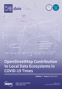
The paper describes the OpenStreetMap (OSM) contribution to address the early stage of the COVID-19 pandemic in Italy. In this period, the Italian OSM community initiated several activities, including adding new data to OSM (e.g., on delivery services of commercial activities), updating OSM data based on governmental datasets (e.g., pharmacies from the Ministry of Health), and publishing web maps offering specific information at the local level. Those initiatives are analyzed from a data ecosystem perspective, identifying actors, data, and data flows involved. The OSM project itself is also assessed within the current European policy context, highlighting opportunities and challenges for scaling successful approaches, such as those to fight COVID-19 from the local to the national and European scales. View this paper
- Issues are regarded as officially published after their release is announced to the table of contents alert mailing list.
- You may sign up for e-mail alerts to receive table of contents of newly released issues.
- PDF is the official format for papers published in both, html and pdf forms. To view the papers in pdf format, click on the "PDF Full-text" link, and use the free Adobe Reader to open them.
Previous Issue
Next Issue