Article

Characteristics and Formation Mechanism of the Majiatan Fold–Thrust System of the Northwestern Ordos Basin


1
Key Laboratory of Agricultural Digital Transformation in Liangshan, Sichuan Province Higher Education Institutions, Xichang 615013, China
2
School of Information Technology, Xichang University, Xichang 615013, China
3
School of Earth Science and Resources, Chang’an University, Xi’an 710054, China
4
School of Mechanical and Electrical Engineering, Xichang University, Xichang 615013, China
*
Authors to whom correspondence should be addressed.
Processes 2026, 14(5), 736; https://doi.org/10.3390/pr14050736
Submission received: 8 January 2026 / Revised: 6 February 2026 / Accepted: 11 February 2026 / Published: 24 February 2026
(This article belongs to the Topic Advanced Technology for Oil and Nature Gas Exploration)

Abstract

The structural characteristics of the Majiatan fault–fold system in the northwestern Ordos Basin are complex, and the detailed 3D distribution of faults and their evolutionary mechanisms remain insufficiently understood, which restricts effective petroleum exploration in this region. To address this, this study utilizes high-resolution 3D seismic data comprising 20 lines (total length 753.371 km, survey grid 3 × 3 km) and drilling and logging data from 13 wells (including synthetic seismograms) to establish a detailed 3D fault model. We aim to elucidate the fault styles and the formation mechanism of the fault–fold–thrust belt. Results indicate the presence of 47 Mesozoic faults, all of which are thrust faults classified into three types. Structural traps dominate the leading transition zone, whereas lithologic–structural traps are prevalent in the Tian-huan Syncline. Laterally, from south to north, the fault occurrence transitions from west-dipping east-thrust to east-dipping west-thrust, accompanied by a shift in tectonic style from thrusting nappe to late-stage reconstruction. The stress intensity generated during the Late Cretaceous increases northward, causing deformation to shift westward. Typical fault styles observed include “y-shaped”, “flower-shaped”, and “imbricated” structures. The middle-north zones of the Majiatan area and the Hengshanbu Thrust Belt share a unified formation mechanism: initiation in the Late Triassic, main development in the Late Jurassic, initial shaping in the Late Cretaceous, and final modification in the Eocene, driven by the rotation of the Ordos Basin and shear tectonic forces. The most favorable exploration zones are identified at the junctions between the leading zone, the fault–fold zone, and weakly transformed zones. The tectonic evolution model established in this study provides a valuable reference for understanding structural complexities and guiding hydrocarbon exploration in similar fold and thrust belts globally.

1. Introduction

Fold and thrust belts (FTBs) are among the most prolific hydrocarbon provinces globally, accounting for a significant portion of the world’s discovered oil and gas reserves. These compressional settings, such as the Zagros Fold–Thrust Belt in the Middle East, the Andes in South America, and the Canadian Rocky Mountains, are characterized by complex structural styles that create diverse trap types, including anticlines, fault-propagation folds, and imbricate zones [1]. Successful exploration in these regions relies heavily on a detailed understanding of the 3D fault distribution, structural evolution, and the interaction between tectonic deformation and sedimentary processes. Consequently, the study of FTBs serves as a cornerstone for petroleum geology, providing analogs and frameworks for understanding complex reservoir systems.
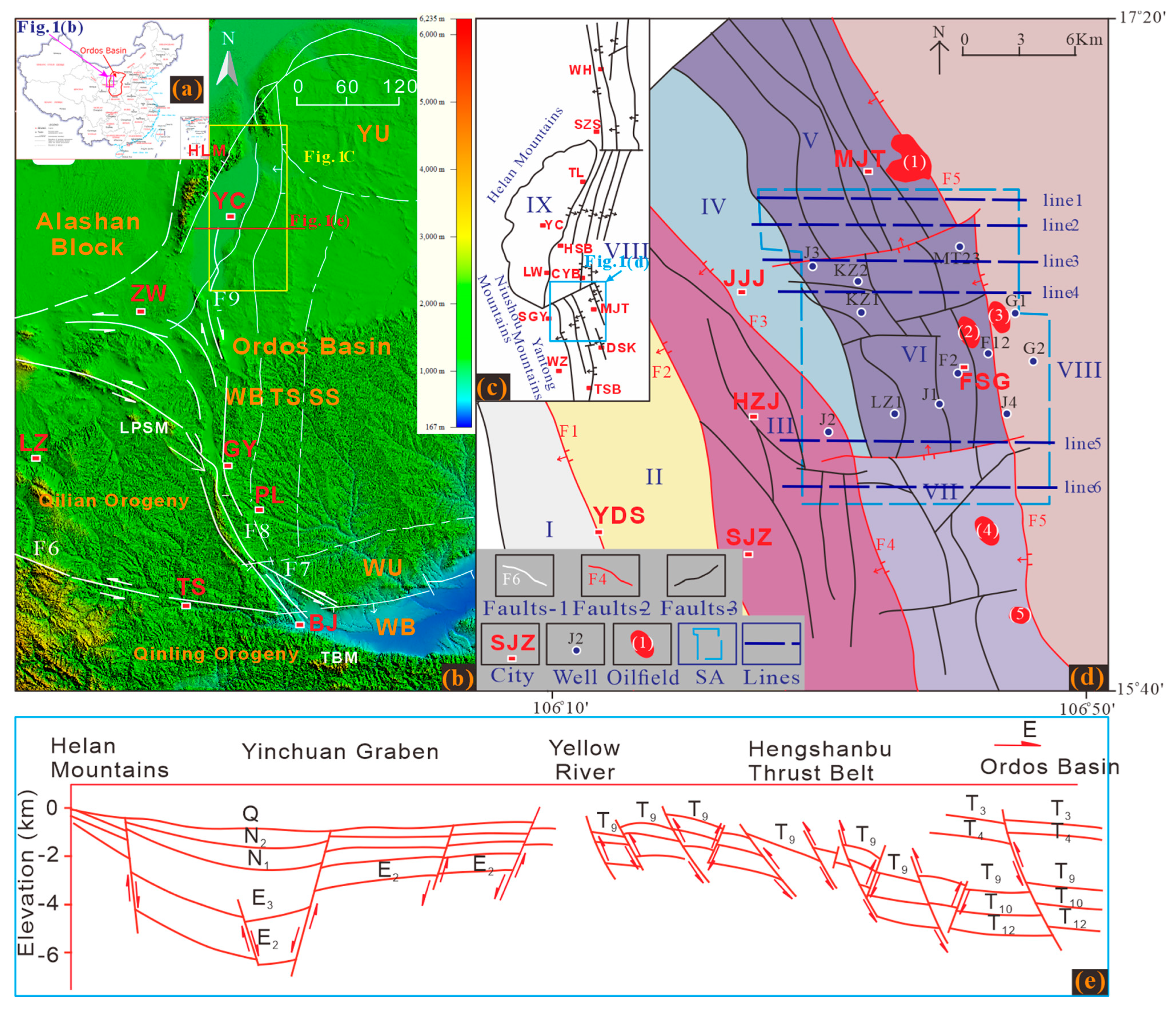
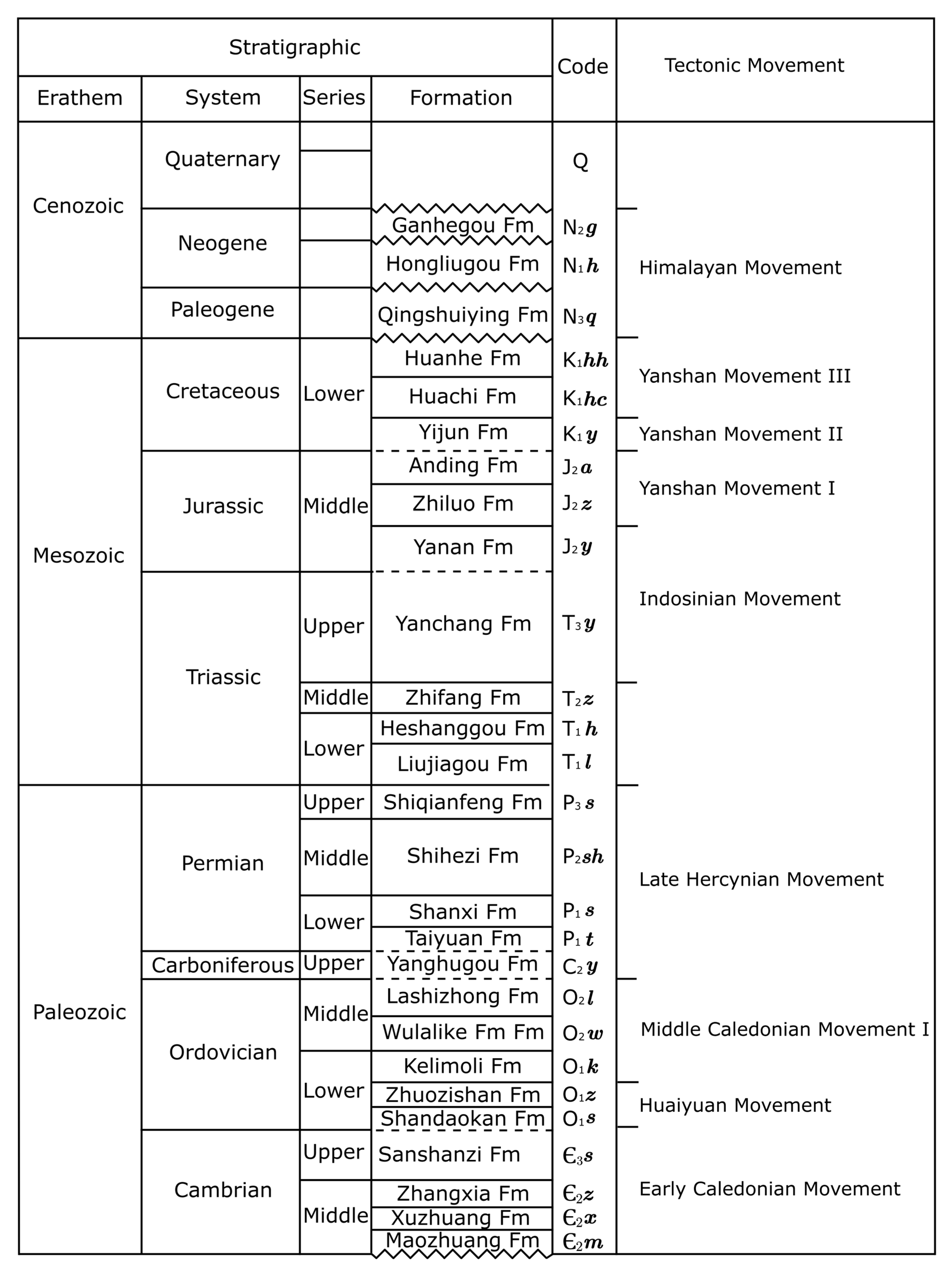
In China, the Western Margin Thrust Belt of the Ordos Basin represents a classic example of such a complex system with immense exploration potential [2]. The Majiatan Fault–Fold Belt, situated between this thrust belt and the Tianhuan Syncline in the Lingwu and Yanchi counties of the Ningxia region (Figure 1), is a key area of interest. This region is characterized by diverse structural styles and a complex evolutionary history influenced by the Helan-Yinchuan Extensional Tectonics, the Liupanshan Thrust, and the Ordos Basin itself [3,4]. These tectonic factors have significantly impacted the hydrocarbon accumulation processes in the Mesozoic and Paleozoic strata. Petroleum exploration in the Majiatan area and its surroundings began in the 1950s. Early efforts led to the discovery of industrial gas flows in the Upper Paleozoic Shihezi and Taiyuan formations and the identification of small fault-block reservoirs [5,6]. Subsequent studies established several oilfields, including the Mafang, Baiyanjing, and Youfangzhuang oilfields, which are primarily reliant on reservoirs in the Yanchang and Yanan formations (Figure 2) [7]. Geochemically, the area possesses high hydrocarbon generation potential, due to the thick lacustrine black mudstone and oil shale in the Chang 7 Member of the Yanchang Formation, which experienced high paleotemperatures during the Late Jurassic and Early Cretaceous [8,9].
Despite a long history of exploration, a systematic understanding of the structural features, spatial distribution, and formation mechanism of the Mesozoic faults in the Majiatan area remains limited. Previous regional tectonic interpretations often lacked the resolution to fully elucidate the complex fault–fold system that is specific to this transition zone. Critical gaps persist in understanding the 3D distribution of reservoir traps, the spatiotemporal relationships between trap formation and hydrocarbon accumulation, and the precise mechanisms driving the fault–fold system’s evolution [10,11].
Therefore, based on data from drilling wells, logging, and 2D/3D seismic surveys, this study focuses on the systematic interpretation of faults and the analysis of trap patterns. We discuss the formation mechanism of the Majiatan fault–fold system and identify favorable traps for petroleum exploration, aiming to clarify the structural controls on hydrocarbon distribution in this key region.

2. Geological Settings

Situated in central-western China, the Ordos Basin is a large superimposed basin developed on the North China Plate [12,13]. The Majiatan region is positioned in the northwestern sector of the basin, bridging the Western Margin Thrust Belt and the Tianhuan Depression. The specific scope of this study is the 3D seismic survey area, highlighted in blue in Figure 1d, which covers an approximate distance of 14 km from north to south and 13 km from east to west. Geologically, the eastern portion of the Majiatan area belongs to the Tianhuan Syncline, where Paleozoic to Cenozoic strata remain relatively horizontal with minimal faulting. Conversely, the central and western sectors fall within the Western Margin Thrust Belt, a region characterized by extensive overthrust and nappe structures [14,15].
Field observations based on the 1:200,000 geological map of the Majiatan area indicate that the surface geology is predominantly covered by tertiary or quaternary sediments, although Mesozoic outcrops—specifically Cretaceous, Jurassic, and Triassic layers—are exposed locally [16,17]. The sedimentary succession in the Majiatan area is detailed as follows.
The Cambrian system is represented by the Sanshanzi Formation, which consists predominantly of dolomite assemblages ranging from dark gray to gray. This unit includes oligodolite and mud-bearing dolomite, and it exhibits a parallel unconformity with the underlying Abuchehai Formation. The Ordovician sequence includes the Lower Sandaokan, Zuozishan, and Kelimoli Formations, which are primarily composed of dark gray to light gray dolomites that are occasionally interbedded with thin limestone layers. The Middle Ordovician Wulalike and Lashenzhong Formations are characterized by turbidite deposits, comprising blackish mudstone, dark gray marl, and light gray limestone.
The Upper Carboniferous to Permian succession is dominated by marine–continental transitional detrital deposits [8,18] and comprises five primary lithostratigraphic units: the Yanghugou, Taiyuan, Shanxi, Shihezi, and Shiqianfeng Formations. These layers rest upon the Ordovician system via either parallel or angular unconformities with the Lower Paleozoic. Lithologically, the Yanghugou Formation consists of quartz sandstone associated with shale and limestone. The Taiyuan Formation is defined by deep ash-black shale and mudstone interbedded with ash-white sandstone. The Shanxi Formation contains grayish-white, thick-to-thin layers of fine to coarse quartz sandstone and hard sandy quartz, alternating with grayish-black mudstone. The Shihezi Formation exhibits distinct lithologic variations between its lower and upper sections, featuring gray-yellowish-green, medium-to-thick beds of coarse quartz sandstone, and gray-green and yellow-green siltstone and mudstone.
The Triassic period begins with the Liujiagou, Heshanggou, and Zhifang Formations in ascending order. These units primarily consist of brown-red siltstone, fine sandstone, and dark gray to brown-red mudstone. In the Middle to Upper Triassic, the Yanchang Formation is observed; it contacts the overlying Yanan Formation with a micro-angular or parallel unconformity and conforms with the underlying Zhifang Formation of the Middle Triassic.
The Yanan Formation is mainly composed of gray to gray-yellow medium-coarse arkose sandstone mixed with deep ash and gray-green mudstone, shale, and coal seams. The Zhiluo Formation is characterized by mudstone interbedded with sand and mudstone in its middle section, while the lower section is typically composed of medium-to-coarse sandstone and gravel-bearing sandstone. The lithology of the Anding Formation primarily consists of gray fine sandstone and brown argillaceous stone, alongside silty mudstone and argillaceous siltstone. The Lower Cretaceous strata consist of sandy conglomerates and mudstone. The Cenozoic era is represented by both Neogene and Paleogene strata. The Quaternary system is ubiquitous across the region, predominantly comprising yellowish loess, sand, and gravel deposits.

3. Data and Methods

3.1. Seismic and Well Data

This study utilized data from twenty 3D seismic lines with a total length of 753.371 km. The survey covers an area of 217.9 km2 with a grid of 3 × 3 km, which tightens to 1 × 3 km in certain areas. Fourteen seismic sections with relatively clear reflection signals crossing the main tectonic belt were reinterpreted. Of these, eleven sections oriented east–west or near east–west in the Shigouyi-Majiatan area were selected to build the 3D model [15]. These include (from north to south): 02xy07, H146543, H126489, 85197, 03xy06, 051493, H116471, 03XY05, H116451, 85101, and 85037. Six sections (H126489, 85197, H116471, H116451, 85101, and 85037) were specifically selected for a detailed discussion.

3.2. Seismic Interpretation and Horizon Calibration

Faults were identified in seismic sections, based on the following six phenomena: (1) reflected waves breaking, bifurcating, merging, or distorting; (2) sudden increase, decrease, or disappearance of reflected in-phase axes; (3) sudden breaks in wave group intervals; (4) sharp changes in seismic events; (5) existence of cross-section or diffraction waves; and (6) smaller coordination faults near larger faults [16,17].
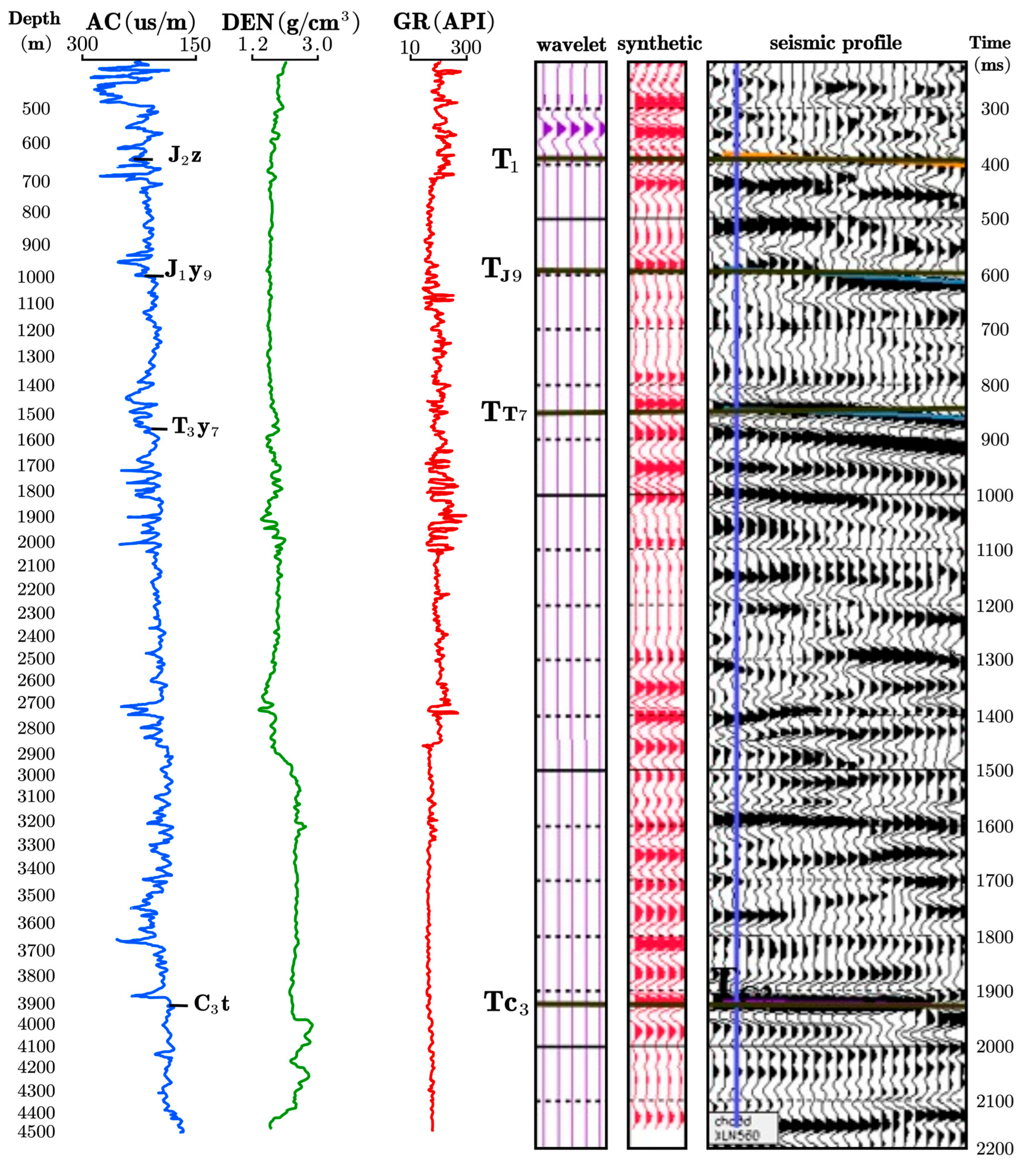
Synthetic seismograms were generated for 13 wells in the study area, with the KS1 well taken as an example (Figure 3). The Syntool sub-module of the OpenWorks software (R5000.8.3) was used to convolute the selected wavelet with the logging reflection coefficient sequence to create a series of synthetic seismic records with positive and negative polarity for each well. After a comparison with the actual seismic data and regional geological characteristics, the synthetic seismic records with positive polarity were selected. The target interval was calibrated using a combination of well logs and seismic sections. The markers T1, TJ9, TT7, and TC3 were calibrated as the main key boundaries for sedimentary tracking (Figure 2). These correspond to the bottom of the Zhiluo Formation (J2z), the Yan9 Member of the Yan’an Formation (T1y9), the top of the first mudstone at the bottom of the Chang7 Member of the Yanchang Formation (T3y7), and the top of the coal seam at the bottom of the Taiyuan Formation (C3t), respectively [9,19]. The boundary between the Paleozoic strata and the overlying strata was marked, and stratigraphic correlation was carried out across multiple wells.
For the synthetic seismogram generation and well–seismic tie (Figure 3), we used a statistically extracted wavelet derived from the stacked seismic data in the vicinity of well KS1. The dominant frequency of the wavelet is approximately 30 Hz, with an effective frequency band of 10–50 Hz, and a total wavelet length of 120 ms sampled at 2 ms. The wavelet was estimated after applying the same preprocessing sequence as was used in the final migrated seismic volume (deconvolution, band-pass filtering, amplitude balancing), ensuring consistency between the synthetic and real seismic response.

3.3. Velocity Analysis and Structure Mapping

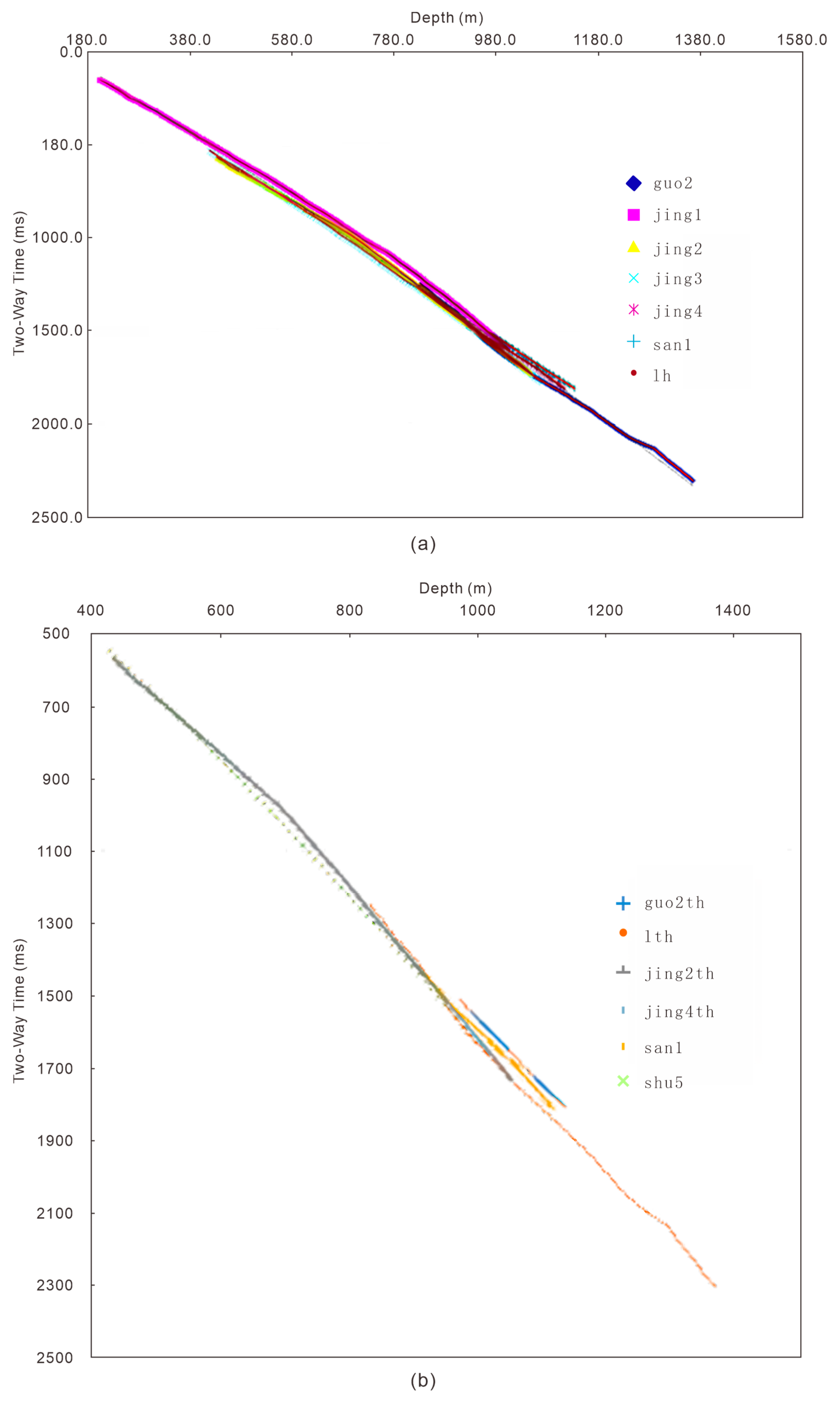
Velocity analysis was conducted separately for uplifted zones and depressions [7]. The analysis indicated that there was little difference in wave velocity between the uplifted and depressed areas, and the time–depth gradient was relatively consistent in both settings (Figure 4). Therefore, a unified method was applied for time–depth conversion.
The specific method for velocity analysis was as follows: First, the average velocity of each drilling well was calculated based on the formation depth and T0 data. Second, an average velocity curve that was applicable to the whole region was synthesized and used to generate the structure maps for TJ2C, TJ9, and TT7. For the TC3 layer, the average velocity was obtained by integrating regional velocity spectrum data with the single available well velocity curve, due to limited well penetration to that depth. The process of creating the structure maps involved: (1) browsing the stack velocity field; (2) checking for and eliminating outliers in the average velocity; (3) correcting the average velocity of each layer using well velocity data; (4) conducting time–depth conversion based on the T0 map; and (5) applying time–depth conversion and drilling corrections to finalize the maps.
Figure 4 shows the time–depth analysis results of multiple exploratory wells in the Majiatan area, which are used to characterize the seismic velocity structure and time–depth relationships in both the uplift and depression zones. Figure 4a presents the two-way travel time versus depth curves for several wells, including guo2, jing1, jing2, jing3, jing4, san1, and lh. Within the main target interval, the differences in two-way time at the same depth among different wells are generally small, and the overall slopes of the curves vary smoothly. This indicates that, whether located in structural uplifts or depressions, the vertical velocity gradients of the stratigraphic units are broadly consistent, and the regional velocity field is relatively uniform, with only limited heterogeneity observed at greater depths.
Figure 4b displays the calibrated and smoothed time–depth curves of a group of representative wells (guo2th, lhth, jing2th, jing4th, san1, and shu5). These refined curves show good consistency at key stratigraphic boundaries (e.g., the Zhiluo Formation, the Yan’an Formation and the main members of the Yanchang Formation), and clearly reveal the overall trend of increasing the average velocity with depth in the target interval. Compared with the more “raw” multi-well comparison in Figure 4a, Figure 4b emphasizes the derivation of practical time–depth functions that can be directly used for time–depth conversion. These functions provide robust velocity constraints for converting seismic profiles from time to depth, for reconstructing structural geometries, and for predicting reservoir burial depth. Taken together, the two panels of Figure 4 suggest that the velocity differences between uplifted and downwarped areas in the Majiatan region are limited, and that the time–depth gradients are generally continuous and smooth across the area, which is favorable for constructing a unified velocity model and improving the accuracy of depth-domain seismic interpretation [20].

4. Results and Interpretation

The fault interpretation was carried out on the final post-stack time-migrated seismic volume. The seismic data were acquired with a 2 ms sampling interval and a recording time of 3000 ms. After processing, the effective frequency content of the stacked data is approximately 10–60 Hz, with a dominant frequency in the target interval of 25–35 Hz.
Assuming an average P-wave velocity of 2800–3500 m/s in the main reservoir and its surrounding formations, the vertical resolution (¼ wavelength) is on the order of 20–30 m within the target interval. The bin size of 25 m × 25 m and the migration aperture yield a horizontal resolution of approximately 30–50 m. Consequently, the interpreted faults mainly correspond to structures with throws larger than 15–20 m, and smaller-scale fractures are only indirectly inferred from amplitude and continuity variations.

4.1. Faults Results

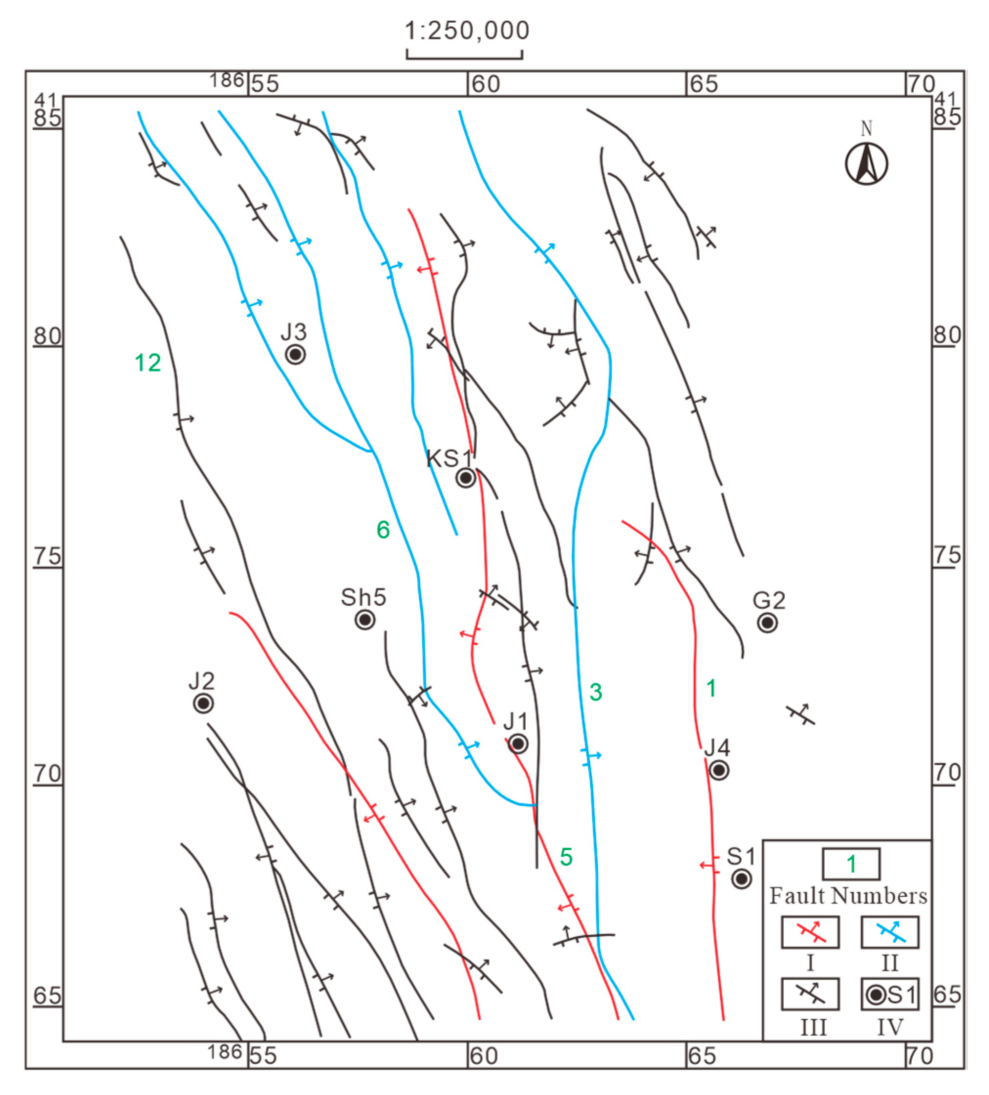
Interpretation results show that there were 47 faults (28 large faults and 19 small ones), all of which were thrust ones (Figure 5). Three first-class faults controlled the boundary of the second-class structural belt, and four second-class faults controlled the distribution of the uplift and depression structural belt. All the major faults strike in the direction of NW and five faults that have a great influence on regional tectonic morphology.
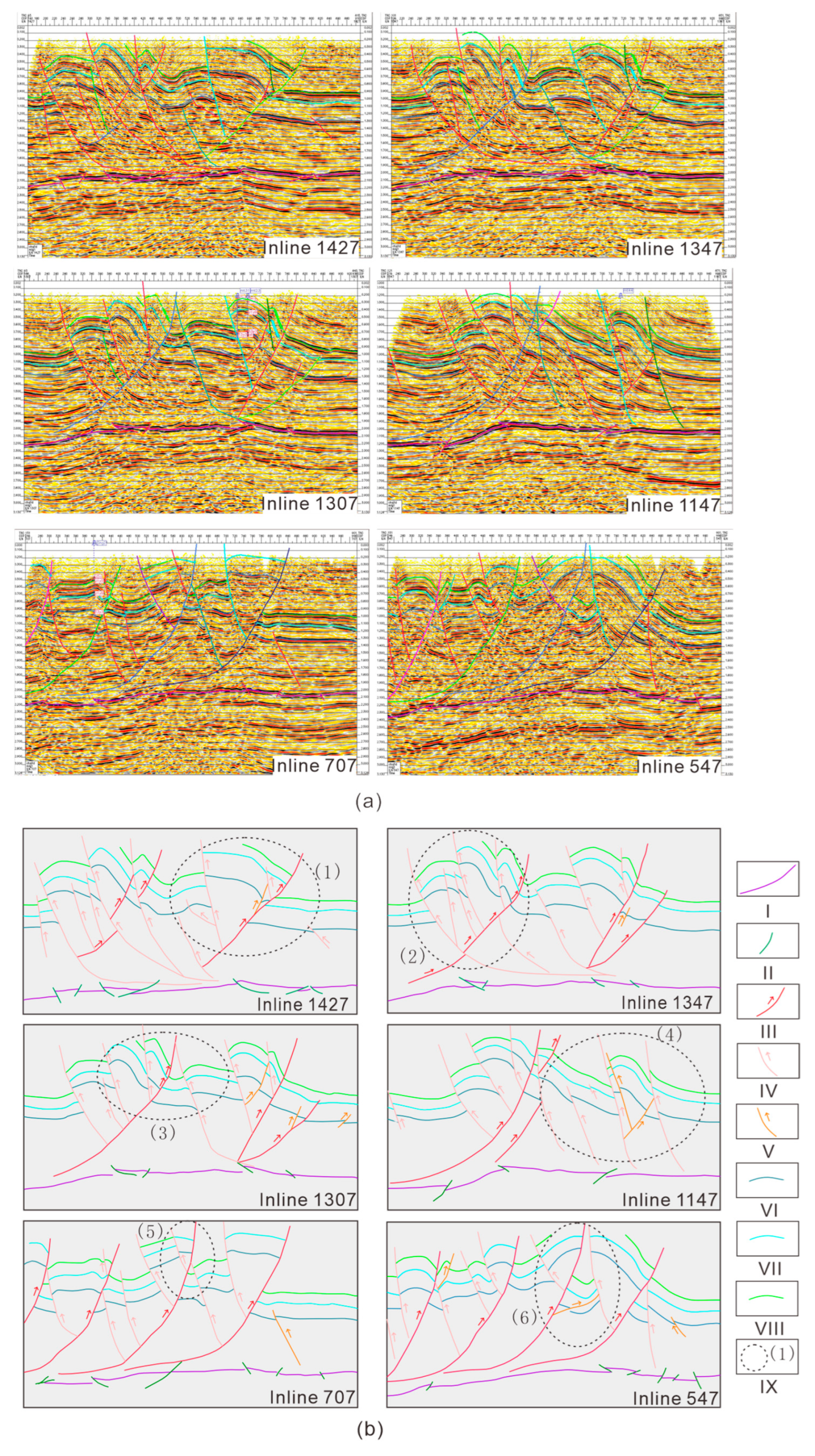
According to the structural interpretation results of the six seismic Inline 547, Inline 707, Inline 1147, Inline 1307, Inline 1347, and Inline 1427 from south to north (Figure 6), the tectonic deformation occurred only in the places near faults, and the thickness of strata far away had uniform changes. Fault and related folds are the basic structural types in the research area. According to the combination relationship, the faults can be divided into three types, which are indicated by red, pink and orange lines, respectively. As can be seen from the figure, the fault combination patterns in the south, the middle and the north in the study area are quite different [15].
The characteristics of the seismic sections in the southern region were shown in the Inline 547 and the Inline 707 (Figure 6a). In Type I, there are a large number of tectonic faults with continuous west–east thrust [2,21]. Type II faults with branching morphology were mingled within faults of type I, which had a limited effect on the reform of the fracture system. Faults of type III were scattered disordered in the distribution in various directions (Figure 6b).
The characteristics of seismic sections in the central region were shown in the Inline 1307, the Inline 1147 and the Inline 1347 (Figure 6a). The number of Type I faults decreased, and the fracture distance in the eastern front zone decreased or was even zero. The strength of faults of type II in the central region was slightly stronger than that in the southern region, which can be reflected in Inline 1307. The upper wall of the fault, including the early branching fault system, faulted with the Carboniferous–Permian as the slip plane and thrust from east to west (Figure 6b). The eastern part of the Inline 1147 showed the thrust character from east to west. Due to the close distance, the structural feature of the Inline 1347 and the Inline 1307 in the middle region were similar to each other (Figure 6a). The reconstruction effect of type II faults in the central region was mainly concentrated in the east, while the effect in the west was weak (Figure 6b).
The seismic sections of the Inline 1427 in the northern region were different from those of the central and the southern regions (Figure 6a). The east-thrust fault of type I was strongly modified by the east–west fault of type II, along with the Carboniferous–Permian interface. The first fault in the west of the section had been divided into several small unconnected faults. Modification in the eastern of the section was weak, with only several small intrastate faults inside gentle strata (Figure 6b).
The No. 1 fault is the boundary fault dividing the Tianhuan Syncline and the Western Thrust Zone in the south–central part of the study area [2,19]. The maximum vertical faulting distance is over 1600 m, and the maximum horizontal faulting distance is over 2000 m. Previous seismic results showed that the fault extended to the northern part of the study area, but these interpretation results showed that the fault should terminate between the seismic line of 02213 and the line of 03205. The fault distance in the line of 03205 did not decrease, and its termination mode may be cut by an east–west fault.
The No. 3 fault is the longest extending fault in this area. It extends northward from the south of the study area to the western boundary of the study area near the line of 03279, with a length of more than 50 km, an easterly inclined section and an inverse fault, a vertical fault distance of 500–170 m and a maximum horizontal fault distance of over 1000 m.
The No. 5 fault extends northward from the south of the study area to the north of the line of 03243, intersecting with the No. 3 fault with a length of ~36 km, a fault section inclined to the west, and an inverse fault with a vertical fault distance of 600–1500 m and a maximum horizontal fault distance of over 1000 m.
The No. 6 fault is the longest arc-shaped fault in this area, with a length of about 40 km from the northeast to the top of the arc, with an easterly inclined fault section, reverse fault, and a vertical fault distance of 500–1500 m.
A section of the No. 12 fault was inclined to the west and reversed with a vertical distance of 500–1600 m and a maximum horizontal distance of 2250 m. However, the extension distance of the fault is short: only 17 km.
In general, from south to north, the occurrence of faults gradually changed from west-dipping to east-dipping, and the tectonic style changed from the thrusting nappe structure from west to east to the complex fault system dominated by the late reconstruction from east to west [10,22].

4.2. Trap Elements

Data of four sets of oil-bearing traps in the study area were obtained (Table 1).
Due to the difference in the degree of tectonic influence, the types of traps change regularly from west to east. The Tianhuan Depression was dominated by the lithologic and structural traps [7].
Structural traps: In the Majiatan fault–fold zone, anticline, fault-anticline, fault nose, and fault blocks could be barriers for hydrocarbon migration to form petroleum reservoirs, such as the Dashuikeng oilfield [9].
Structural–lithologic traps: The lithologic transformation zone in the higher position inside fault nose or fault-anticline would generate petroleum reservoirs.
Lithologic traps: The lower Jurassic strata were deposited above the pre-Jurassic paleo-ravine. The sandstone pinch-out to the dip direction ravine, taking the overlying mudstone as the cap layer, forms the lithologic traps. According to petroleum exploration, lithologic traps, such as channel sand and delta sand, were developed in this area.

4.3. 3D Model of the Fault System

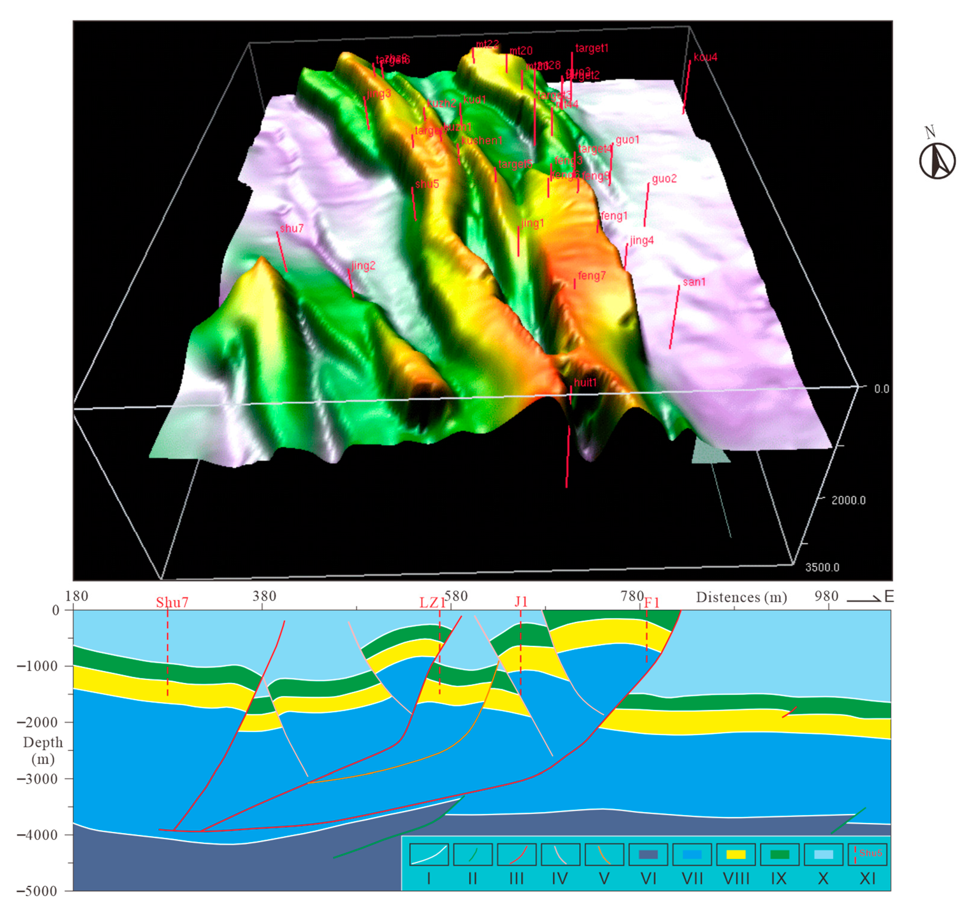
In terms of fault combination styles, asymmetric faulted anticline and faulted syncline are the main structural styles in the study area. The concomitant thrust fault and reverse thrust fault with overthrust fault formed the style of “y” structure [16]. According to the three-dimensional modeland section characteristics (Figure 7), the eastern part of the study area was divided into three sections: the south, the north, and the middle. The middle and south sections were mainly composed of thrust faults, secondary recoil faults, and fault clips between them, which constitute the style of “y” structure. The fault–fold belt of the Shenjiazhuang-Haizijing region was a uniformed structure composed of a group of wing-type overthrust faults with west-dipping and east-thrusts with an alternate pattern of arc-shaped fractures and ridges.
It can be seen from the established three-dimensional structural model (Figure 7) that the study area is a large nappe tectonic system with two ridges and two depressions formed by a series of east-thrust faults and interposed folds. From north to south, the degree of tectonic deformation gradually increased. Five thrust faults with extension lengths ranging from 25 to 47 km developed from west to east, including the Huianbu Fault, the Shenjiazhuang Fault, the Jijiajing Fault, the Maerzhuang Fault, and the Majiatan Fault.
Most of the faults, except the reverse fault, spread in the west dip direction. The anticlines in the region had the feature that was steeped in the east wing and gentle in the west wing (Figure 7) [21]. In the area east of the Majiatan Fault, the degree of tectonic deformation reduced and had fewer faults and more gentle strata.

5. Discussion

5.1. Styles of Faults and Their Combinations

The structural characteristics of the Majiatan Fold–Thrust System interpreted in this study are consistent with the broader geological context of the Ordos Basin’s Western Margin. Located in the central part of this margin, the Majiatan area is a key component of the “38° tectonic belt” [19], serving as a structural transition zone between the southern and northern sections [23]. Regional tectonic zoning reveals a shift in fracture orientations from NNW to NNE and SN from north to south, dividing the margin into the Zhuozishan, Hengshanbo, Majiatan, and Shajingzi sections [23]. Our findings align with previous studies indicating that the Majiatan area is the most intensely deformed segment, dominated by thrust nappe structures [6,21,24] and exhibiting the highest density of hydrocarbon traps [19].
This structural complexity is facilitated by two primary decollement surfaces: the interface between the Carboniferous coal measures and overlying strata, and the basement interface [15,16]. These layers allow for the differential movement required to form the complex thrust–fold belt. The Majiatan Fault trends NNW with a maximum displacement of approximately 1000 m [5]. West of this fault, the region is intensely folded and densely faulted, whereas the eastern side remains relatively gentle [17]. The deformation intensity diminishes southwards, with fault throws gradually decreasing until they vanish near the Dashuikeng area [17]. This spatial pattern reflects the intense structural deformation and finalization that occurred during the Mesozoic–Cenozoic era.
The specific structural styles and their spatial variations revealed by the seismic interpretation are primarily controlled by stress interactions along these decollement layers. The thrust stress from west to east caused slip surfaces inside the Carboniferous system, and the upper strata slid from west to east. Under the local press from east to west, thrust movement occurred to the west in the slip surface, original faults or sedimentary strata, generating multiple branch faults and forming different fault structural styles. The thrusting movement of type II faults from south to north gradually enhanced the strength of the original system transformation, and the objects gradually moved westward. Type III fault was a local adjustment fault, which only developed among faults or within the sedimentary strata, and had a limited transformation effect on the original structural system.

5.2. Formation Mechanism of the Thrust–Fold Belt in the Majiatan Area

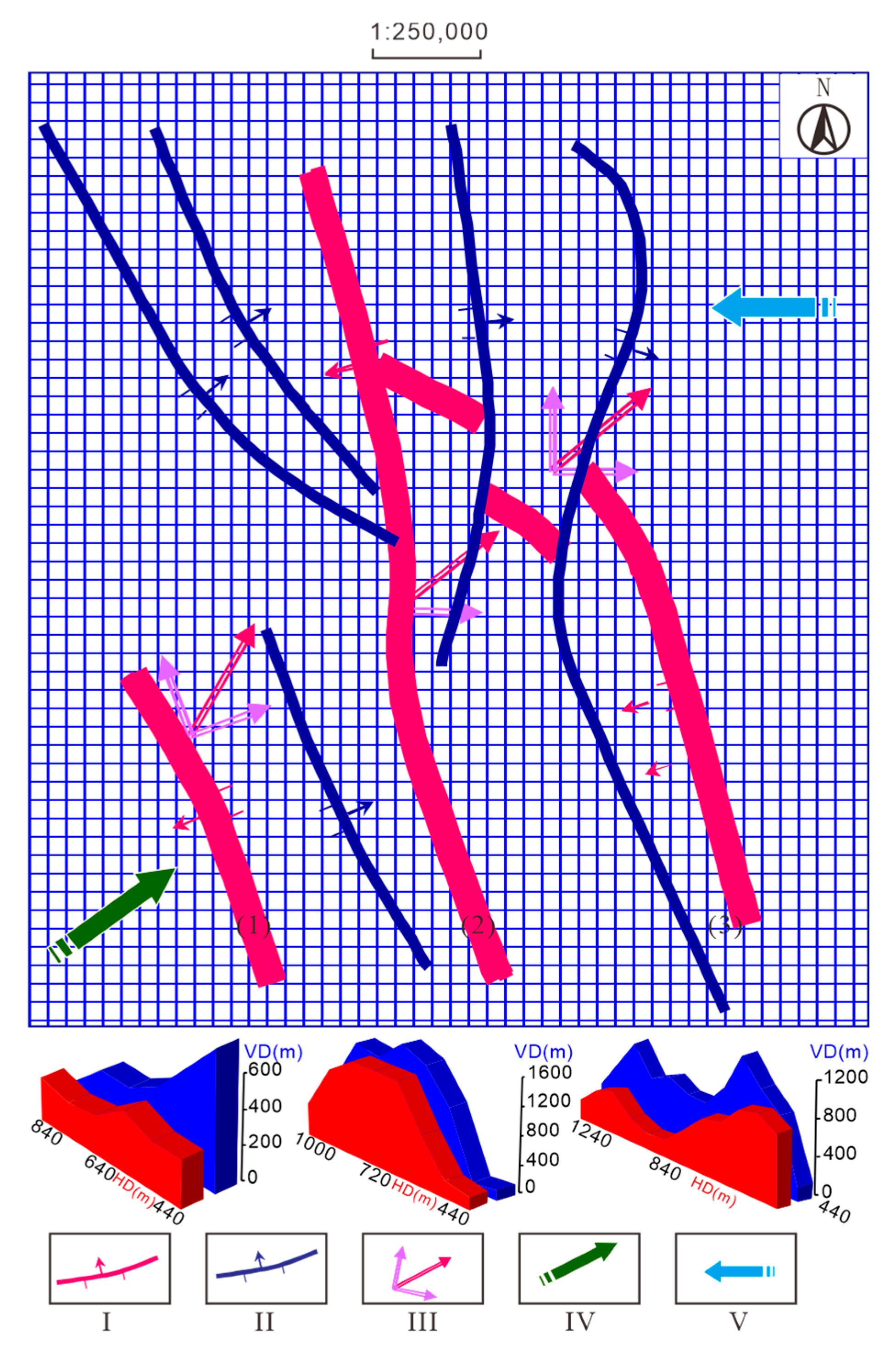
In the Hengshanbu thrust belt, the coal-bearing strata of the Carboniferous System were taken as the decollement layer, and the main thrust plane was inclined to the east, while the thrust block was inclined to the west. As a result, the thrust fault was a relatively gentle and limited distance of thrust [5]. From north to south, the development scale and strength of the east-dipping west-thrust fault decreased and disappeared in the central and southern regions. The middle-north region of the Majiawan area can be regarded as the continuation and the end of the Hengshanbao Thrust Belt. Both of the two areas had a unified formation mechanism (Figure 8), showing as follows:
(1) Foundation of the basement from the Proterozoic to Early Paleozoic
This area was in the middle of the Qinling–Qilian Rift and the Helan Rift. The final stabilization of the North China Plate finished in the Paleoproterozoic [25,26]. The Early Paleozoic neritic carbonate strata were deposited on the Lower Proterozoic metamorphic basement and the middle-upper Proterozoic platform. During the Late Caledonian, after the Qing–Qi–He Trifurcation Rift closed and uplifted into a mountain, the study area uplifted and was eroded, and the strata from the upper Ordovician to the lower Carboniferous were missing. During the Early Hercynian Movement, the Helan Aulacogen split again, and the platform again subsided, leading seawater to intrude into the platform and a set of sea and land in coal measures strata was deposited [27]. In the Early Permian, the seawater had withdrawn completely; it gradually transformed into a lakeside delta facies. The Hercynian movement at the end of the Permian made most of the Western Margin of the Ordos Basin uplift and caused a hiatus [19].
(2) Basic tectonics during the Middle-Late Triassic
During the Middle-Late Triassic, a set of Late Triassic continental sedimentary strata was deposited in the Ordos Basin [28,29], and the Majatan area was a relative subsidence area [19]. During the Indosinian Movement, the ancient Tethys Sea expanded to the north with SW-NE pressure, reducing the western-leaning normal faults thrust. The Qingtongxia-Guyuan Fault in the west of the study area thrusted eastward, causing slight folds in the middle-upper Triassic strata and angular unconformity with the upper Jurassic strata, such as the low-angle unconformity contact between the Yanan formation and the Yanchang formation in the Shigouyi region [30]. At this time, the overthrust nappe tectonic movement occurred in the western margin of the Ordos Basin [31], but there was no fault movement [32].
(3) Main development during the Late Jurassic
The Yanshan Orogeny was an important movement for the tectonic evolution of the North China Plate [22]. In the Middle Jurassic, the northern section of the Western Ordos Basin changed from the N-S compression of the Indosinian period to the E–W-compression of the Yanshan period [33,34]. During the Late Jurassic, the Tethys tectonics converged from the South China Plate to the North China Plate, and the Siberian Plate collided from the north to the south to the North China Plate, causing the Alashan Block to push eastward with an east–west compression on the western margin of the Ordos Basin [35]. This movement caused a strong thrust deformation, uplift and denudation [19] to the western margin of the Ordos Basin, different styles of thrust faulting and fold belt, and erosion of the lower Jurassic with an angular unconformity contact with the lower Cretaceous Formation. The Anding Formation was covered with the Qingshuiying Formation and no late Jurassic sediments remained [30].
Therefore, it can be seen that the strong thrust–fold structure in the Majatan area and its northern region was mainly formed in the Late Jurassic, which was closely related to the strong compression of the Alashan Block in the west, which has continued to squeeze eastward since the late Jurassic [36].
(4) Cretaceous
The Cretaceous strata in the east of the study area were faulted by faults of type II (Figure 6, Figure 7 and Figure 8), indicating that the regional tectonic movement since the Cretaceous had a certain transformation effect on the fault system formed in the early stage. Features were shown as follows.
Sediments of the Early Cretaceous overlapped with the eroded Late Jurassic deposits in the Western Margin Thrust Belt, and extended westward [19,37], and had unconformity contacts with the underlying strata of the Fenfanghe Formation in the western Majiatan area and the Anding Formation in the eastern Majiatan area. Although there were some activities in the Majitan area, the tectonic activities were relatively weakened compared with the previous activity, with only slight fold fault. The lower Cretaceous deposited widely in the western margin of the Ordos Basin. According to the thickness restoration results of the strata, the paleo-thickness of the lower Cretaceous was nearly 900 m. During this period, the thrust and fault tectonic movement in the northern part of the western margin of the Ordos Basin developed further and a series of imbricated thrust faults formed.
(5) Tectonic inversion during the Himalayan Movement in the Cenozoic
Due to the northward movement of the Indian Plate and the subduction of the Pacific Plate to the Eurasia Plate at 50 ± 10 Ma [38], a unique tectonic movement occurred in the western margin of the Ordos Basin. The southern part of the Helanshan tectonic belt was related to the rapid uplift of the Qinghai–Tibet plateau in the late Miocene [3,39,40]. The northern section formed the tectonic pattern of the fault basin and mountains with the Helan Tectonic Belt due to the extrusion and dislocation of the southern materials during the movement to the northeast.
The Majiatan area is located in the combination and transition zone of the northern part and the southern part of the Western Ordos Basin [2] and was controlled by both the southern thrust tectonic system and the northern compression–torsional tectonic system. For the formation mechanism of the Hengshanbu reverse thrust system, it has been explained by the theory of recoil fault, the wedging action of strata below the Carboniferous system, or the pressure torsion caused by some rotation movement of the Ordos Basin and its surroundings [5]. This research supports the third interpretation. Due to the NNE compression of the Indian Plate since Eocene [40,41], the Ordos Basin and its surrounding areas have been rotated anticlockwise in the Late Cenozoic [42]. At that time, the western margin of the basin had been subjected to tensile stress, and the eastern area of the Alashan Block had reversed and collapsed along the early-formed thrust fault to form the Yinchuan Basin. In the Hengshanbu Thrust Belt and the northern part of the Majiatan area, the faults and related folds were formed by a regional compression and torsion action from east to west. This can be proven by the characteristics of the echelon arrangement of this region [17].
In a word, the Majiatan area was influenced and controlled by different tectonic movements in different periods. The embryonic form appeared at the end of the Late Triassic, was mainly formed in the Late Jurassic, was basically formed in the Late Cretaceous, and has transformed since the Eocene. This is consistent with the previous understanding that fractures in the study area can be divided into three types (Figure 8). The type I faults were formed in the Late Jurassic, and the type II faults (dark blue lines in Figure 8) were formed under the shear compression and torsion action in the Late Cretaceous, causing some of type I faults to misbreak (Figure 8).

5.3. Implications for Hydrocarbon Exploration and Trap Evaluation

Source rocks of the Yanchang Formation in this area yielded plenty of hydrocarbon during the Late Jurassic–Early Cretaceous [13,43,44,45,46] at the same time as the thrust activities in the Majatan area. Analysis of reservoir structure and traps are very important in optimizing favorable exploration areas.
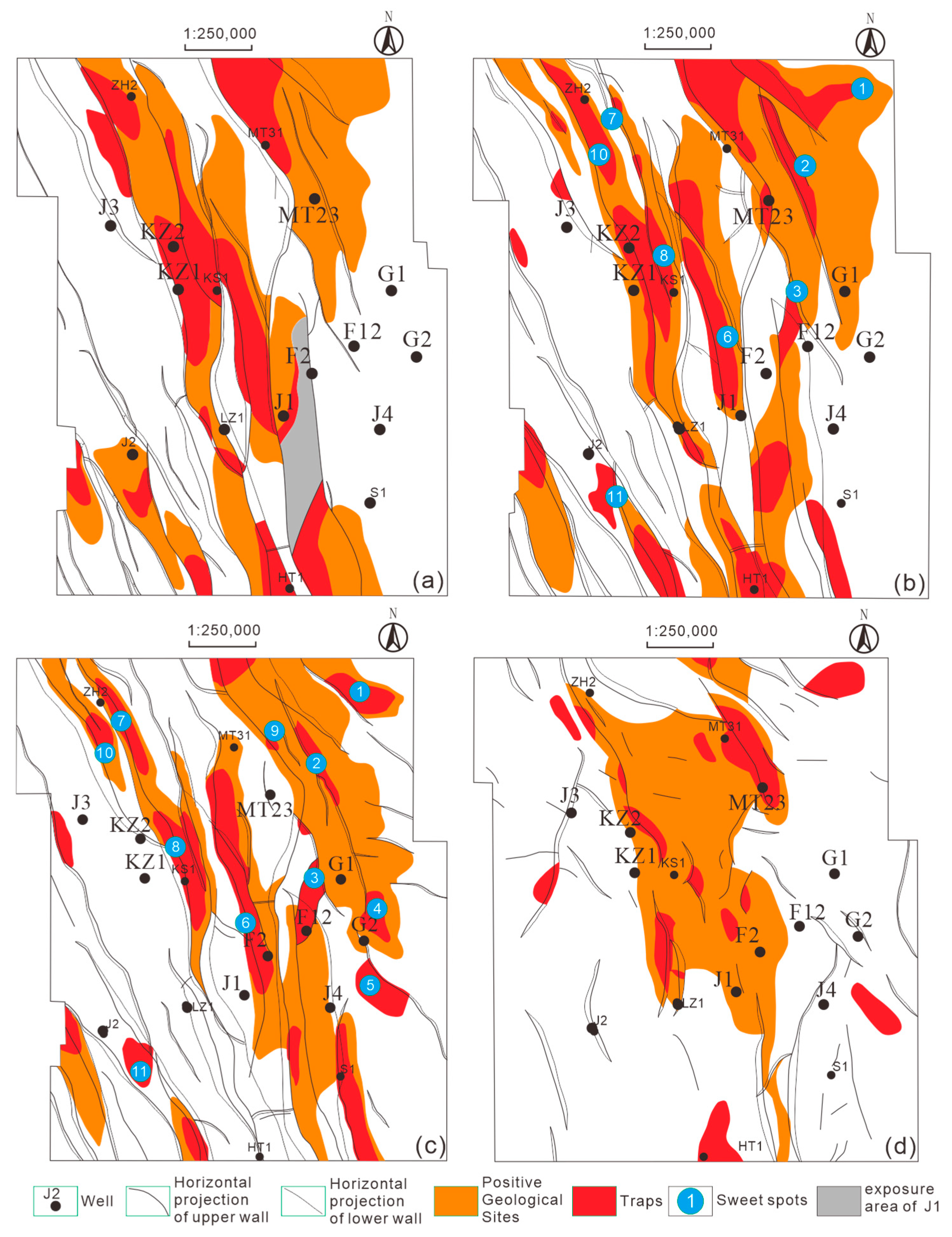
According to the oil and gas development status and the structural maps of the Zhiluo Formation, the Yanan Formation, the Yanchang Formation and the Taiyuan Formation (Figure 9), the oil reservoirs are mainly distributed in the front belt of the fault–fold area, and most of them are held between fault blocks, which indicates that faults played a very important role in oil and gas migration and accumulation.
Some drilling in the study area was not effective, such as the J1 well. The reason may be that the fault could not be closed due to the influence of late fault activity. According to the structure of the J4 well, the structure is a concave uplift with a small uplift amplitude, which is not conducive to the accumulation of oil and gas. Recent strong activity may lead to poor fault sealing, resulting in no hydrocarbon accumulation in the above wells. Therefore, it is better to look for faults with small spacing and uncontacted permeable sandstone on both upper sides of the transverse faults. Generally speaking, faults having an inverse break and small angle is more acceptable.
The preservation condition analysis of structural–lithologic traps plays an important role in drilling well deployment [47]. According to the above analysis, the strata above the slipped plane napped from west to east for a certain distance. Conditions for petroleum preservation in the fault block traps controlled by early faults were inferior to those controlled by late faults. The junction of the leading edge zone and the stable platform, where the fold deformation is weak and there are fewer faults, is beneficial to the preservation of oil and gas. In the south of the leading edge zone, the Cenozoic tectonic transformation was relatively small and there are many uplift structures with high regional tectonic positions. For example, the stable platform area in the east of the fault–fold zone, where three anticlines have been found, was affected by the thrust fault with slight folds, few faults, and small fault spacing, and had favorable conditions for oil reservoirs. On the Yandunshan area where the thrust fault exists, the structural–lithologic traps would be the first choice for reservoir exploration, such as the Haizijing fault anticline [9]. Uplift structures that are close to the discovered oil fields in the south of the leading edge may have potential hydrocarbon accumulation capability.
Based on the above analysis, the suggested traps of the Yan’an Formation and the Yanchang Formation for further exploration and their elements were shown in Table 2.
The Majiatan anticline is located on the high fault block held by the No. 4 east-dipping fault and the No. 7 west-dipping fault. Although the tectonic position is high, it is cut by multiple faults with a small distance and morphological integrity.
The low-amplitude anticline, No. 9 trap and No. 4 trap of the southeast slope of the Majiatan anticline have oil reserves in the Guo2 well. No. 6, No. 7, and No. 8 have similar trap conditions to the J3 well, which has petroleum as shown in the Yanchang Formation. All these regions can be sweet spots for further hydrocarbon exploration.

6. Conclusions

(1) The Magatan 3D seismic exploration area is a large nappe tectonic system with two ridges and two depressions, formed by a series of near N-S faults and interposed folds.
(2) In the study area, 28 large faults and 19 small faults developed in the Mesozoic. All the major faults strike in the direction of MW. Fault patterns include the shape of “y”, the shape of “flower” and the shape of “imbricate”. The faults can be divided into type I of west–east thrust faults, type II of east–west faults and type III of late transformation faults, which formed in the Late Jurassic, Late Cretaceous and later stages, respectively.
(3) The study reveals a distinct tectonic evolution model that is characterized by significant north–south zonation. From south to north, the deformation mechanism transitions from west-dipping east-thrust nappe structures to east-dipping west-thrust systems dominated by late-stage reworking, with the center of deformation shifting from east to west. The northern part of the Majiatan area represents the southern termination of the Hengshanbu Thrust Belt. This tectonic evolution occurred in four stages: embryonic formation in the Late Triassic, main development during the Late Jurassic (Yanshanian Orogeny), structural finalization in the Late Cretaceous, and superimposed transformation during the Cenozoic (Himalayan Orogeny), driven by regional rotation and extension.
(4) The trap types changed regularly from west to east in the Majiatan 3D exploration area. The leading edge transition zone was dominated by structural traps, while the Tianhuan Syncline was dominated by structural–lithologic traps. The most favorable exploration area in the study area is the combination region of the leading edge belt, the fault–fold belt, and the stable platform of the basin.

Author Contributions

Methodology, B.W. and Q.Y.; Validation, Q.Y.; Resources, B.W.; Data curation, Q.Y., F.T. and L.Z.; Writing—original draft, B.W. and Q.Y.; Writing—review and editing, B.W. and Q.Y.; Visualization, B.W., Q.Y., F.T. and L.Z. All authors have read and agreed to the published version of the manuscript.

Funding

This research was funded by the Research Start-up Project for Newly Recruited Ph.D.s of Xichang University, grant number YBZ202138; the Big Data Laboratory for Characteristic Agricultural R&D of Liangshan, grant number 015/117235000; Reserve Funding under the Climbing Plan for Scientific Research of Xichang University, grant number 015/117630094; and Research on Fluid Migration and Accumulation Characteristics and Controlling Factors in Medium-High Water Cut Gas Reservoirs of PetroChina Changqing Oilfield Company, grant number CQYT-CQKTY-2025-JS-1747.

Data Availability Statement

The original contributions presented in this study are included in the article. Further inquiries can be directed to the corresponding authors.

Conflicts of Interest

The authors declare no conflict of interest.

References

  1. Jia, C.Z. The Petroleum Exploration in Thrust Belt of Foreland Basin; The Petroleum Industry Press: Beijing, China, 2000; pp. 24–30, (In Chinese with English abstract). [Google Scholar]
  2. Yang, H.; Tao, J.Q.; Ouyang, Z.J.; Li, G.; Jing, C.L. Structural characteristics and forming mechanism in the western margin of the Ordos Basin. J. Northwest Univ. (Nat. Sci. Ed.) 2011, 41, 863–868, (In Chinese with English abstract). [Google Scholar]
  3. Shi, W.; Dong, S.W.; Liu, Y.; Hu, J.M.; Chen, X.H.; Chen, P. Cenozoic tectonic evolution of the South Ningxia region, northeastern Tibetan Plateau inferred from new structural investigations and fault kinematic analyses. Tectonophysics 2015, 649, 139–164. [Google Scholar] [CrossRef] [Scilit]
  4. Yang, X.Y.; Dong, Y.P. Mesozoic and Cenozoic multiple deformations in the Helanshan Tectonic Belt, Northern China. Gondwana Res. 2018, 60, 34–53. [Google Scholar] [CrossRef] [Scilit]
  5. Yang, J.J.; Zhang, B.R. Torsional-type Graben and Associated Thrust Belt: A Case Study of the Yinchuan Graben and Hengshanbu Thrust Belt. Pet. Explor. Dev. 1986, 13, 1–8, (In Chinese with English abstract). [Google Scholar]
  6. Zhao, C.Y. Preliminary study on tectonic evolution and plate stress mechanism of western Ordos. In Petroleum Geology Symposium of the Western Edge of the Ordos Basin; Petroleum Society of Inner Mongolia Autonomous Region, Ed.; The People’s Publishing House of Inner Mongolia: Hohhot, China, 1983; pp. 20–28, (In Chinese with English abstract). [Google Scholar]
  7. Pang, C.Y.; Zhang, Y.D.; Wang, J.; Wu, T.L. Structural Features of the Middle Section and Its Petroleum Exploration Prospects in the West Margin of Ordos Basin. Geoscience 2016, 30, 274–285, (In Chinese with English abstract). [Google Scholar]
  8. Ren, Z.L.; Zhang, S.; Gao, S.L.; Cui, J.P.; Xiao, Y.Y.; Xiao, H. Tectonic thermal history and its significance on the formation of oil and gas accumulation and mineral deposit in Ordos Basin. Sci. China Ser. D Earth Sci. 2007, 50, 27–38. [Google Scholar] [CrossRef] [Scilit]
  9. Xi, S.L.; Li, W.H.; Li, R.X. Hydrocarbon generation and reservoir formation: A case from Chang 7 source rock in Majiatan area, west margin of Ordos Basin. Pet. Explor. Dev. 2008, 35, 657–663, (In Chinese with English abstract). [Google Scholar]
  10. He, D.F. Geometry and kinematics of Majiatan Fold-and-thrust Belt, Western Ordos Basin: Implication for Tectonic Evolution of North-South Tectonic Belt. In Proceedings of the American Geophysical Union, New Orleans, LA, USA, 11–15 December 2017. [Google Scholar]
  11. He, D.F.; Shao, D.B.; Cui, Y.P.; Bao, H.P.; Kai, B.Z.; Fu, D.W.; Cao, Y.G. Delineation, formation, and geological significance of Majiatan paleo-uplift at the western margin of Ordos Basin. Acta Pet. Sin. 2018, 39, 609–619, (In Chinese with English abstract). [Google Scholar]
  12. Xu, Q.H.; Shi, W.Z.; Xie, X.Y.; Busbey, A.B.; Xu, L.; Wu, R.; Liu, K. Inversion and propagation of the Late Paleozoic Porjianghaizi fault (North Ordos Basin, China): Controls on sedimentation and gas accumulations. Mar. Pet. Geol. 2018, 98, 706–722. [Google Scholar] [CrossRef] [Scilit]
  13. Yu, Q.; Ren, Z.L.; Zhu, Z.W.; Tao, N.; Wang, B.J.; Li, C.C. Exhumation, cooling and erosion history of Triassic oil shale since Late Cretaceous, Binxian-Tongchuan area of Ordos Basin. J. Earth Sci. 2018, 43, 1839–1849, (In Chinese with English abstract). [Google Scholar]
  14. Tang, X.Y.; Guo, Z.M.; Chen, H.L. The Study and Petroleum Prospect of the Thrust Nappe in the West Margin of Shaanxi-Gansu-Ningxia Basin; Northwest University Press: Xi’an, China, 1992; (In Chinese with English abstract). [Google Scholar]
  15. Zhang, J.; Ma, Z.J.; Ren, W.J. Tectonic Characteristics of the Western Ordos Thrust-Fold Belt and the Causes for its north-south segmentation. Acta Geol. Sin. 2004, 78, 600–611, (In Chinese with English abstract). [Google Scholar]
  16. Wang, Z.C.; Wang, Y.X. Detachment-type thrust structures in Majiatan, West Margin of Ordos. Oil Gas Geol. 1996, 17, 221–225, (In Chinese with English abstract). [Google Scholar]
  17. Zhang, B.R. On the twisting feature of the fold-fault zone in Majiatan. Acta Pet. Sin. 1982, 2, 15–20, (In Chinese with English abstract). [Google Scholar]
  18. Guo, P.; Ren, D.S.; Xue, Y.H. Simulation of multi-period tectonic stress fields and distribution prediction of tectonic fractures in tight gas reservoirs: A case study of the Tianhuan Depression in western Ordos Basin, China. Mar. Pet. Geol. 2019, 109, 530–546. [Google Scholar] [CrossRef] [Scilit]
  19. Liu, C.Y.; Zhao, H.G.; Wang, F.; Chen, H. Attributes of the Mesozoic structure on the West Margin of the Ordos Basin. Acta Geol. Sin. 2005, 79, 737–747, (In Chinese with English abstract). [Google Scholar]
  20. Ren, Z.L.; Yu, Q.; Cui, J.P.; Qi, K.; Chen, Z.J.; Cao, Z.P.; Yang, P. Thermal history and its controls on oil and gas of the Ordos Basin. Earth Sci. Front. 2017, 24, 137–148, (In Chinese with English abstract). [Google Scholar]
  21. Guo, Z.M.; Zhang, J. A discussion on the oil and gas potential of the structural belt in the west margin of the Ordos Massif viewed from the thrust nappe tectonics. Acta Pet. Sin. 1989, 10, 31–38, (In Chinese with English abstract). [Google Scholar]
  22. Dong, S.W.; Zhang, Y.Q.; Li, H.L.; Shi, W.; Xue, H.M.; Li, J.H.; Huang, S.Q.; Wang, Y.C. The Yanshan orogeny and late Mesozoic multi-plate convergence in East Asia—Commemorating 90th years of the “Yanshan Orogeny”. Sci. China Earth Sci. 2018, 61, 1888–1909. [Google Scholar] [CrossRef] [Scilit]
  23. Yang, J.J. The Tectonic Evolution and Petroleum Distribution Law; Petroleum Industry Press: Beijing, China, 2002; pp. 25–27. (In Chinese) [Google Scholar]
  24. Luo, Q. Characteristics of faults in Majiatan area of west Ordos Basin and their petroleum reservoir controlling model. Acta Geosci. Sin. 2008, 29, 619–627, (In Chinese with English abstract). [Google Scholar]
  25. Zhao, G.C.; Cawood, P.A.; Li, S.Z.; Wilde, S.A.; Sun, M.; Zhang, J.; He, Y.H.; Yin, C.Q. Amalgamation of the North China Craton: Key issues and discussion. Precambrian Res. 2012, 222–223, 55–76. [Google Scholar] [CrossRef] [Scilit]
  26. Zhao, G.C.; Sun, M.; Wilde, S.A.; Li, S.Z. Late Archean to Paleoproterozoic evolution of the North China Craton: Key issues revisited. Precambrian Res. 2005, 136, 177–202. [Google Scholar] [CrossRef] [Scilit]
  27. Xu, S.M.; Feng, H.W.; Li, S.Z.; Li, M.; Somerville, I.; Bi, H.M.; Ji, Y.; Ye, Q. Closure time in the East Qilian Ocean and Early Paleozoic ocean continent configuration in the Helan Mountains and adjacent regions, NW China. J. Asian Earth Sci. 2015, 113, 575–588. [Google Scholar] [CrossRef] [Scilit]
  28. Gao, Y.; Jiang, Z.X.; Best, J.L.; Liu, S.Q.; Zhang, J.G. Small- and large- scale soft-sediment deformations in a Triassic lacustrine delta caused by overloading and seismicity in the Ordos Basin, central China. Mar. Pet. Geol. 2019, 103, 126–149. [Google Scholar] [CrossRef] [Scilit]
  29. Li, Y.H.; Song, Y.; Jiang, Z.X.; Yin, L.S.; Luo, Q.; Ge, Y.J.; Liu, D. Two episodes of structural fractures: Numerical simulation of Yanchang Oilfield in the Ordos basin, northern China. Mar. Pet. Geol. 2018, 97, 223–240. [Google Scholar] [CrossRef] [Scilit]
  30. Zhou, L.F.; Zhao, C.Y.; Guo, Z.M. Formation and Evolution of the Alashan Block and Adjacent Areas; Northwest University Press: Xi’an, China, 1995; (In Chinese with English abstract). [Google Scholar]
  31. Wang, C.S.; Dai, J.G.; Zhao, X.X.; Li, Y.L.; Graham, S.A.; He, D.F.; Ran, B.; Meng, J. Outward growth of the Tibetan Plateau during the Cenozoic: A review. Tectonophysics 2014, 621, 1–43. [Google Scholar] [CrossRef] [Scilit]
  32. Zhao, H.G.; Liu, C.Y.; Wang, J.Q.; Wang, F.; Yin, Y. Tectonic attribute of the western Ordos Basin during the Late Triassic. Geol. China 2007, 34, 384–391, (In Chinese with English abstract). [Google Scholar]
  33. Dong, S.W.; Zhang, Y.Q.; Chen, X.H.; Long, C.X.; Wang, T.; Yang, Z.Y.; Hu, J.M. The formation and deformational characteristics of East Asia multi direction convergent tectonic system in Late Jurassic. Acta Geosci. Sin. 2008, 29, 306–317. [Google Scholar]
  34. Yang, M.H.; Li, L.; Zhou, J.; Jia, H.C.; Sun, X.; Qu, X.Y.; Zhou, D.; Gong, T.; Ding, C. Mesozoic structural evolution of the Hangjinqi area in the northern Ordos Basin, North China. Mar. Pet. Geol. 2015, 66, 695–710. [Google Scholar] [CrossRef] [Scilit]
  35. Liu, S.F. The coupling mechanism of basin and orogen in the western Ordos Basin and adjacent regions of China. J. Asian Earth Sci. 1998, 16, 369–383. [Google Scholar] [CrossRef] [Scilit]
  36. Zhao, H.G.; Liu, C.Y.; Wang, F.; Wang, J.Q.; Li, Q.; Yao, Y.M. Uplift and evolution of Helan Mountain. Sci. China Ser. D Earth Sci. 2007, 50, 217–226. [Google Scholar] [CrossRef] [Scilit]
  37. Li, R.X.; Liang, J.W.; Weng, K. Paleo-reservoir bitumen of the middle Protozoic Jixian system in the southwest margin of the Ordos basin, China. Pet. Explor. Dev. 2011, 38, 168–173. [Google Scholar] [CrossRef] [Scilit]
  38. Yin, J.X.; Xu, J.T.; Liu, C.J.; Li, H. The Tibetan plateau: Regional stratigraphic context and previous work. Philos. Trans. R. Soc. Lond. Ser. A 1988, 327, 5–15. [Google Scholar]
  39. Ren, Z.L.; Cui, J.P.; Liu, C.Y.; Li, T.J.; Chen, G.; Dou, S.; Tian, T.; Luo, Y.T. Apatite fission track evidence of uplift cooling in Qiangtang basin and constraints on the Tibetan Plateau uplift. Acta Geol. Sin. 2015, 89, 467–484. [Google Scholar]
  40. Sun, J.P.; Dong, Y.P. Middle–Late Triassic sedimentation in the Helanshan Tectonic Belt: Constrain on the tectonosedimentary evolution of the Ordos Basin, North China. Geosci. Front. 2019, 10, 213–227. [Google Scholar] [CrossRef] [Scilit]
  41. Yu, Q.; Ren, Z.L.; Li, R.X.; Tao, N.; Qi, K.; Jiang, C.; Wang, B.J. Meso-Cenozoic Tectonothermal History of Permian Strata, Southwestern Weibei Uplift: Insights from Thermochronology and Geothermometry. Acta Geol. Sin. 2019; in press. [CrossRef] [Scilit]
  42. Zhang, Y.Q.; Liao, L.Z. Transition of the Late Mesozoic-Cenozoic tectonic regimes and modification of the Ordos Basin. Geol. China 2006, 33, 28–39. [Google Scholar]
  43. Li, R.X.; Liu, F.T.; Li, S.Z.; Xi, S.L.; Daniel, J.L. Magmatic activities and their impacts on oil-gas formation in the Southwestern Ordos Basin, Central China. Geol. J. 2017, 53, 178–189. [Google Scholar] [CrossRef] [Scilit]
  44. Yang, P.; Ren, Z.L.; Xia, B.; Liu, W.L.; Huang, Q.T. Tectonic-thermal evolution history and its controls on petroleum geology of Weibei Uplift. Acta Geol. Sin. 2017, 91, 144–145. [Google Scholar] [CrossRef] [Scilit]
  45. Yu, Q.; Ren, Z.L.; Li, R.X.; Wang, B.J.; Qin, X.L.; Tao, N. Paleogeotemperature and maturity evolutionary history of the source rocks in the Ordos Basin. Geol. J. 2017, 52, 97–118. [Google Scholar] [CrossRef] [Scilit]
  46. Ren, Z.L. Thermal history of Ordos Basin assessed by apatite fission track analysis. Chin. J. Geophys. 1995, 38, 233–247. [Google Scholar]
  47. Ni, J.; Ren, Z.L.; Wang, X.Z.; Zhan, Z.Y. Theoretical derivation and application research of stepped horizontal well patterns with coupling reservoir/wellbore flow in multilayer reservoir. Energy Explor. Exploit. 2013, 31, 77–87. [Google Scholar] [CrossRef] [Scilit]
Figure 1. (a) Locality map. (b) Western part of the Ordos Basin. (c) Northern part of the Western Ordos Basin, with a blue rectangle showing the study area, which is shown in detail in (d), division of tectonic units. (e) Geological section of the Helan Mountains—the Ordos Basin in the direction of W–E. Fault 1, fault 2, and fault 3 are all faults on a different scale, including F1: Huianbu Fault, F2: Shenjiazhuang Fault, F3: Jijiajing Fault, F4: Maerzhuang Fault, F5: Majiatan Fault, F6: Western Qinling Fault, F7: Longxian–Qishan–Mazhao Fault, F8: Liupanshan Fault, and F9: Luoshandonglu Fault. Oilfields include (1): the Majiatan oilfield, (2): the Fengjigou reservoir, (3) the Guo2 well reservoir, (4) the Yu4 well reservoir, and (5) the Yu1 well reservoir. SA with 3D seismic data is the research area. City names include YDS: Yandunshan, SJZ: Shenjiazhuang, HZJ: Haizijing, JJJ: Jijiajing, MJT: Majiatan, FSG: Fengshigou, YC: Yinhuan, ZW: Zhongwei, GY: Guyuan, PL: Pingliang, LZ: Lanzhou, TS: Tianshui, BJ: Baoji, WH: Wuhai, SZS: Shizuishan, TL: Taole, HSB: Hengshanbu, LW: Lingwu, CYB: Ciyaobu, SGY: Shigouyi, DSK: Dashuikeng, WZ: Weizhou, and TSB: Tianshuibu. Tectonic units include YU: Yimeng Uplift, SS: Shanbei Slope, WU: Weibei Uplift, WB: Weihe Basin, TS: Tian-huan Syncline, and WT: Western Margin Thrust Belt. Mountains include HLM: Helan Mountains, LPSM: Liupanshan Mountains, TBM: Taibai Mountains. I: Shigouyi-Huianbo Sag, II: Shenjiazhuang Slope, III: Shenjiazhuang-Haizijing fault–fold belt, IV: Jijiajing Syncline belt, V: Flower-shaped fault block zone, north of the Majiatan county, VI: fault–fold zone, south of the Majiatan county, VII: Yu4 Reservoir zone, and VIII: eastern gentle fold zone. Line 1: Inline 1427, Line 2: Inline 1347, Line 3: Inline 1307, Line 4: Inline 1147, Line 5: Inline 707, and Line 6: Inline 547. Q: Quaternary system, N2: Pliocene, N1: Miocene, E3: Oligocene, E2: Eocene, T3: seismic interface of bottom of the Cretaceous, T4: seismic interface of bottom of the Jurassic, T9: seismic interface of top of the Carboniferous, and T10: seismic interface of top of the Ordovician.
Processes 14 00736 g001
Figure 2. Stratigraphic column and tectonic movements of the Majiatan area.
Processes 14 00736 g002
Figure 3. Seismic synthetic of the Kushen1 well.
Processes 14 00736 g003
Figure 4. Velocity analysis diagram of exploratory wells. (a) Comparison of time–depth relationships from multiple exploratory wells in the Majiatan area. The figure shows two-way travel time (TWT) versus depth curves for wells guo2, jing1, jing2, jing3, jing4, san1, and lh. Within the main target interval, the curves exhibit similar shapes and smooth time–depth gradients, indicating limited vertical velocity differences among wells located in both uplift and depression zones and a generally uniform regional velocity field. (b) Calibrated time–depth relationships for representative exploratory wells in the Majiatan area. The figure presents the smoothed and fitted TWT–depth curves of wells guo2th, lhth, jing2th, jing4th, san1, and shu5, derived from well–seismic calibration. The curves show good consistency at key stratigraphic boundaries and clearly illustrate the increase in average seismic velocity with depth in the target interval, providing practical velocity constraints for time–depth conversion and detailed structural interpretation in the study area.
Processes 14 00736 g004
Figure 5. Planar map of fault system of the Chang7 member in the Majiatan area. Type I: main NNW-trending thrust faults; Type II: branching or reactivated faults; Type III: local adjustment faults; and Type IV: well locations.
Processes 14 00736 g005
Figure 6. Faults system of the Majiatan area. (a): Image of an interpreted seismic section, (b): Sketch faults and boundaries of sedimentary formations. I: bottom of the Taiyuan Formation, Carboniferous (C3), II: faults formed during Late Paleozoic, III: faults of Type I, IV: faults of Type II, and V: faults of Type III. The arrows indicate the direction of tectonic movements. VI: Bottom of the Chang7 Member in the Yanchang Formation, Triassic (T7), VII: bottom of the Yan9 Member in the Yan’an Formation, Jurassic (J9), and VIII: bottom of the Zhiluo Formation of Mid-Jurassic (J2Z). IX: representative fault styles, including (1): reversed faults; (2): flower-like faults; (3): reverse-thrust faults; (4): imbricated-thrust faults; (5): X-shaped reversed faults; and (6): faults of three-phase reversal. Positions of all the seismic sections were displayed in Figure 1.
Processes 14 00736 g006
Figure 7. 3D tectonic model of the Majiatan area. The lower part is the interpretation of wells of Shu7-LZ1-J1-F1. I: boundaries of sedimentary formations, II: faults formed in Late Paleozoic, III: faults formed in the first phase, IV: faults formed in the second phase, V: faults formed in the third phase, VI: Ordovician, VII: Carboniferous–Permian, VIII: Triassic, IX: Lower Jurassic, X: Jurassic-Cretaceous, and XI: drilling wells.
Processes 14 00736 g007
Figure 8. Formation model of the Majiatan Faults. I: the 1st faults, II: the 2nd faults, III: decomposition of stress, IV: the 1st tectonic stress, and V: the 2nd tectonic stress.
Processes 14 00736 g008
Figure 9. Tectonic maps of reservoirs. (a): Bottom of the Zhiluo Formation, (b): bottom of the Yan9 member of the Yan’an Formation, (c): bottom of the Chang7 member of the Yanchang Formation, and (d): bottom of the Taiyuan Formation.
Processes 14 00736 g009
Table 1. Data of traps in the Majiatan area, Western Ordos Basin.
Tectonic NamesFMClosure
Area (m2)
Closure
Height (m)
Closure
Amplitude (m)
Representative
Lines
Anticline to the west of the ZH2 wellJ1y93.61400150I 1400 C 380
T3y35.01900150
Fault block of the KZ1 wellJ1y911.320025011080 C 500
T3y38.5500250
Fault block of the KD1 wellJ2c7.4400250I 1240 C 580
J1y99.5600450
T3y34.11000250
Majiatan anticline (local area)J2c32.4300950I 1320 C 700
J1y921.34001250
T3y324.58001250
Fault block to the north of the J1 wellJ1y96.53003501960 C 620
T3y38.1700650
Fault noses of the J2 wellJ2c6.7500250I 640 C 420
J1y91.590050
Fault noses to the south of the J2 wellJ1y92.5300250I 480 C 520
T3y33.5500750
Fault noses of the S1 wellJ1y92.313003501520 C 800
T3y34.01900250
Anticline of the F7 wellJ1y913.8200150T 680 C 740
T3y318.0500350
Fault block of the HT1 wellJ1y94.5200150I 520 C 660
Fault block of the J1 wellJ2c5.2200450I 780 C 680
Fault noses of the J3 wellJ2c2.950050I 1280 C 340
Fault block of the ZZ2 wellJ2c26.0200250I 1320 CA 20
Fault block to the east of the ZZ2 wellJ2c24.0200350I 1400 C 440
Anticline to the north of the J3 wellTc30.8415025I 1360 C 340
Anticline belt of the KS1 wellTc360.43900225I 1040 C 620
Majiatan anticline (local area)Tc32.63900225I 1440 C 660
Anticline to the northeast of the G3 wellTc33.3410025I 1420 C 900
Anticline to the east of the J4 wellTc31.9415025I 760 C 980
Fault noses to the south of the J3 wellTc30.9455025I 1000 C 320
Anticline to the west of the HT1 wellTc32.3410025I 500 C 660
Table 2. Suggested traps and their elements for exploration.
No.StrataTrap Area (km2)Trap Height (m)Trap Amplitude (m)Lines
1J1y92.31400150I 1407 C 870
T3y32.6207540
2J1y92.5800450I 1267 C 770
T3y31.61600150
3J1y91.51500150I 987 C 770
T3y31.61600350
4J1y9/ I 967 C 880
T3y31.6210040
5J1y9/ I 817 C 900
T3y32.8212540
6J1y95300250I 947 C 630
T3y37.8700350
7J1y93.5300150I 1367 C 380
T3y32.4600150
8J1y94250150I 1067 C 480
T3y34.8500150
9J1y9/ I 680 C 1320
T3y3195015
10J1y90.380050I 1320 C 320
T3y31.3115040
11J1y90.8167540I 1100 C 240
T3y31.1200015
Disclaimer/Publisher’s Note: The statements, opinions and data contained in all publications are solely those of the individual author(s) and contributor(s) and not of MDPI and/or the editor(s). MDPI and/or the editor(s) disclaim responsibility for any injury to people or property resulting from any ideas, methods, instructions or products referred to in the content.