Abstract
Wheelchair users face environmental barriers that limit their mobility and social participation. Although existing navigation tools support urban mobility, they often lack clear orientation and confirmation cues, and information on accessible and safe routes to meet wheelchair users’ needs. This study aims to identify the most adapted route instructions for wheelchair users, examine characteristics’ (sociodemographic information and profiles) impact on their instructions’ choices, and evaluate instruction’s delivery modalities. An online questionnaire collected participants’ characteristics and agreement with the proposed route instruction formulations (different combinations of information like turn-by-turn instructions, landmarks, and accessibility information) regarding clarity, sufficiency, adaptability, and safety criteria. Formulations were evaluated across 14 navigation situations involving accessibility and safety challenges. Participants also rated communication modalities. 32 wheelchair-users (19 males, 13 females; mean age = 45.8 years; mean wheelchair experience = 23.5 years) participated. Data analysis reveals the importance of enriched turn-by-turn instructions, including non-turning actions, alerts, landmarks, and/or street names for participants. Alert-based formulations were favored in most situations, like uneven sidewalks, slopes and intersections. More enriched instructions were significantly acceptable among women and participants with greater wheelchair experience. Multimodal delivery, particularly visual and audio information, was also preferred. These findings help develop adaptive navigation tools, improving wheelchair users’ safe, confident mobility, autonomy, and social participation.
1. Introduction
Mobility-related disability represents one of the most prevalent forms of disability around the world. According to the World Health Organization (2023), an estimated of 16% of the global population experiences a significant disability, among them, 1% require a wheelchair for their mobility [1,2]. According to Statistics Canada on disability (2023), 10.6% of Canadians aged 15 and older report mobility-related disabilities [3]. Smith et al. (2016) reported that about 1% of the Canadian population was using wheelchairs and scooters for mobility [4]. Diverse environmental factors (e.g., steep slopes, narrow sidewalks, or social relations) often limit their mobility [5,6,7,8]. These challenges may affect multiple aspects of life, including health, safety, autonomy, social participation, and access to education, employment, public services, and healthcare [9]. Although wheelchair users may experience functional limitations, disability is shaped by their interaction with their environments [10]. Hence, improving these interactions is essential for enhancing their mobility and social participation.
Assistive navigation technologies played an essential role in supporting daily mobility and significantly changed the way people interact with their environment [11,12]. Prevalent tools, such as Google Maps, often deliver turn-by-turn (TBT) route instructions (e.g., information on distance, directions, and street names (SNs)) to guide users during their navigation [13]. However, these routing instructions often have drawbacks, including user distraction from the surroundings [14,15], reduced spatial learning [14,15] and a lack of clarity and sufficient information (e.g., landmarks (LMs) and Points of Interest (POIs)) [16,17] which can cause confusion in different situations. In contrast, route directions provided by people typically include environmental cues, LMs, slopes, POI, intersection types, confirmatory information, and non-turning actions [16,17,18,19,20]. Such information may help to improve navigation performance for all, especially people with mobility limitations.
Despite recent advances, mainstream assistive navigation technologies and their route instructions mainly target the general public and often neglect the specific needs of wheelchair users for navigation [21,22]. Prior studies report dissatisfaction among people with mobility disabilities with these tools [21,22]. Gupta et al. (2020) indicated that people with mobility disabilities noted dissatisfaction with the poor quality of directional guidance provided by assistive technologies, which frequently led to disorientation and forced them to rely on strangers [22]. According to their results, many participants preferred LM-based route instructions over distance-based instructions and often considered some obstacles as LMs. Similarly, based on findings from a usability study of Google Maps, Vincent et al. (2022) reported low satisfaction among wheelchair users with Google Maps’ navigation assistance, information about safety-critical situations, and hands-free operation [21]. Because wheelchair users need their hands to propel their wheelchairs, hands-free navigation support is really helpful for safe navigation [23]. Hence, adapted tools are required to better address the navigational needs of wheelchair users, thereby supporting their mobility and social participation.
Wheelchair users’ navigational needs and behavior differ from those of the general population. Accessibility and safety challenges strongly influence their wayfinding performance and wayfaring experiences (i.e., embodied multisensorial experiences that occur while traveling) [8,24]. During navigation, wheelchair users require careful identification and analysis of diverse barriers on their route to ensure safe passage, especially in unfamiliar areas [8,25]. Being significantly concerned with safety and security factors can reduce the attention required for wayfinding actions and cues, such as street signs or buildings [8,24,26]. Additionally, the limited viewing angles from their wheelchairs may delay detection of environmental features, adversely affecting their route-following and causing dangerous situations. For example, parked vehicles can block the view of traffic during street crossings [8,25]. Errors or unexpected barriers in these situations can risk their safety, forcing unsafe actions or rerouting. Moreover, wheelchair users with different profiles and capabilities (i.e., the potential to perform mental or physical activities) may interact differently with obstacles and barriers and experience different navigational behavior [10]. These factors highlight the need to consider these navigational needs, profiles, and wheelchair users’ behavior when designing and developing adapted assistive navigation technologies and adapted route guidance.
Although several projects and specialized tools, such as HandiMap (https://www.handimap.fr/, accessed on 1 December 2025), Wegoto (https://wegotrack.eu/, accessed on 1 December 2025), mPASS, and StreetCo (https://street-co.com/en/app/streetnav, accessed on 1 December 2025) [27,28] have been developed to assist wheelchair users with mobility, they still present limitations. Many of these tools often do not provide sufficiently detailed information through their guidance to satisfy wheelchair users’ navigational needs and profiles. They mainly rely on distance or timing information, which is often difficult for travelers to interpret, while LMs for orientation, often preferred by users, are mostly missing [20]. Tools like HandiMap also fail to clearly communicate accessibility challenges along the route, leaving users uncertain about the obstacles they may encounter. Although mainstream navigation technologies like Google Maps have recently introduced accessibility features for wheelchair users (e.g., accessibility information for entrances and restrooms) in certain countries, they often lack essential information on the safety and accessibility of pedestrian networks to efficiently guide wheelchair users during navigation. These limitations may adversely affect wheelchair users’ mobility, increase reliance on others, and limit access to essential services and social participation, ultimately affecting autonomy and well-being.
Therefore, it is essential to provide wheelchair users with rich and adapted route instructions that include pertinent information and their efficient combination to address their needs and profiles and improve their interaction with the environment during navigation. As summarized in Table 1, although the combinations of LM in TBT have been studied to facilitate navigation for the general population, they are often overlooked in existing navigation tools [16,17] and are not adapted to wheelchair users [8,22,24]. In addition, the optimal combination and efficiency of these components for wheelchair users have rarely been studied [8,22,24]. In addition, current assistive navigation tools often ignore or inadequately convey information about accessibility and safety challenges within route instructions [21,22]. Their integration into route instructions for wheelchair navigation has also not been sufficiently studied. These gaps highlight the need to evaluate the adaptability and efficiency of these information components for wheelchair users, identify the appropriate level of detail and the optimal combination of these components, and assess their efficient communication modalities for wheelchair navigation.

Table 1.
Information components for route guidance studied in previous research, and their limitations for wheelchair navigation.
The main objective of the present study is to identify the most adapted route instruction formulations (combinations of information components) to support wheelchair users’ mobility in urban environments. Secondary objectives include examining the impact of wheelchair users’ sociodemographic backgrounds and profiles on their choices of these adapted route instructions, as well as evaluating sensory modalities for communicating these instructions. To address these objectives, an online survey was conducted to collect participants’ sociodemographic data and profiles, their adapted route instructions’ choices based on different criteria (e.g., clarity, sufficiency, adaptability, and safety), and their choices of communication modalities for these instructions. The study tested the following hypotheses: H1: Wheelchair users will highly agree with the adapted TBT instructions with non-turning actions (e.g., street crossings), enriched with information on accessibility and safety challenges, and LM in different navigation situations. H2: Wheelchair users’ sociodemographic data and profiles would significantly impact their choices of the adapted route instructions. H3: Wheelchair users prefer multimodal communication of the route instructions (visual and vocal indications) during navigation. The findings of the present study will guide the development of an adaptive route-instruction generation engine algorithm for wheelchair users to facilitate safer and more confident navigation, thereby improving their independent mobility and social participation.
The remainder of this paper is organized as follows. In Section 2, participants and their recruitment, the required materials for designing the online questionnaire, the questionnaire structure, and procedure for collecting data, as well as the collected data analysis are explained. The results are presented in Section 3. Discussion on the findings of this study, along with the study’s strengths, limitations, and future work, is provided in Section 4. The conclusions are explained in the last section.
2. Materials and Methods
We conducted an online survey using a questionnaire to address the objectives of this study. This study protocol was approved by the Research Ethics Board in rehabilitation and social integration at the Centre intégré universitaire de santé et de services sociaux de la Capitale-Nationale (REB number: 2023-2649, _RIS).
In this section, we first describe the selection criteria and recruitment of participants. We then outline the materials used to design the proposed adapted route instructions for the online questionnaire. Finally, we explain the questionnaire’s design, structure, and implementation procedure.
2.1. Participants and Recruitment
The online survey was developed using Limesurvey software (LimeSurvey GmbH, Hamburg, Germany) and was entirely in French. It was spread through several channels, including email, social media, the websites of local special-interest groups, and flyers. The survey remained open for participant recruitment from February to August 2025. Overall, thirty-two wheelchair users were recruited. Eligible participants were required to be at least 18 years old, have a minimum of 1 year of independent outdoor wheelchair use (to maintain the reliability of data collection) [29], and at least 1 year of experience with navigation technologies (e.g., Google Maps). They also needed to understand simple route instructions and complete an online questionnaire in French. The presence of additional disabilities was not used as an exclusion criterion. Participants’ contact information was collected for compensation and to verify responses. All participants signed the consent form required to participate in the survey. Completing the questionnaire took approximately one hour per participant.
2.2. Materials for Designing the Questionnaire
This section describes the information components and formulations used to design the proposed adapted route instructions for the online questionnaire.
2.2.1. Information Components for the Adapted Route Instructions
As a preliminary step in designing adapted route instructions for wheelchair users, we were inspired by standard TBT instructions in conventional navigation tools such as Google Maps, enriched with additional information components, such as LMs. SNs in TBT instructions help users identify their route and maintain orientation while navigating. Prominent streets are more likely to be recognized by individuals navigating them [30]. However, several studies highlighted that pedestrians often prefer LMs over SNs as the latter may be more difficult to memorize, or their signs may be obstructed or missing [31]. LMs support orientation, decision-point identification, and route confirmation by linking routes to the environment, improving navigation performance [32,33], although their adaptivity and efficiency for wheelchair navigation require further investigation. Hence, LMs were considered as an essential component of our proposed route instructions and evaluated through the questionnaire. In this study, LMs were represented by points, lines, and polygons based on their functional role and spatial extension.
Numerous studies have highlighted the importance of information on accessibility and safety challenges for wheelchair navigation [8,21,24,34,35]. Providing Wayfaring information (e.g., upcoming intersections) may allow wheelchair users to better prepare for and manage these issues along the route and so improve their confidence and navigation performance [8,24,36,37,38]. In this way, Alerts were considered in our proposed route instruction formulations. The common accessibility obstacles and safety concerns considered in our study were based on previous work [35] on personalized route planning and navigation for wheelchair users. The main environmental dynamic and static factors that were considered for alert design include steep upward slope (>5%), steep downward slope (<−5%), transversal slope (>2%), cobblestone and uneven sidewalk, snow (a sidewalk covered in 2 inches of snow), hole (2 inches deep), flat and loose gravel path (3 m), the path over grass, tree roots and rocks, going up/down a curb (15 cm height), an intersection without a pedestrian light, pressing the pedestrian light call button and cross the street before the lights change, a crowded sidewalk, and narrow sidewalk. The detailed alerts designed to address these challenges are shown in Table 2. Some obstacles, like slopes, also shape the structure of the environment and make route parts particular for wheelchair users in some situations, helping with route direction-finding and route confirmation [39].
Table 2.
Designed alerts for common accessibility obstacles and safety challenges.
Street crossings are particularly complex and safety-critical for wheelchair users, where they need to assess intersection layout, traffic flow, vehicle speed, and pedestrian signals and their accessibility levels. Then, they need to plan and execute safe crossing strategies by evaluating vehicle speed and determining the safe moment and conditions to cross the intersection within the limited crossing time [25,40]. Previous studies have highlighted that crossings pose heightened risks and demand greater caution for wheelchair users compared to the general population [24,25]. The absence of guidance in the route instructions regarding where to cross streets [21] further deteriorates these challenges for them. In this way, information on street-crossing actions was also considered in our proposed route instructions. To include street crossings in our instructions, we also needed to account for potential continuing straight actions following a street crossing to better guide users in such cases.
2.2.2. The Proposed Adapted Route Instruction for Wheelchair Users
To design route instructions, we have considered the aforementioned information components, including (1) TBT route instructions, (2) LMs, (3) Alerts for accessibility and safety, as well as (4) non-turning actions, including street crossings. The design of the adapted route instructions was also informed by the quality criteria for efficient route instruction design reported in numerous previous studies [20,41]. These works emphasize quality criteria, including completeness (i.e., containing all necessary information, with sufficient detail to reach the destination), and clarity (i.e., unambiguous references, easy to understand, map to the real world, and follow to reach the destination). For wheelchair users, additional requirements included adaptivity to their needs and profiles, as well as ensuring their safety during navigation [22]. Inspired by these criteria and the route instructions of common assistive navigation tools, the information components were combined and structured by a PhD student in Geomatics with the help of a research assistant in Geomatics with experience in wheelchair users’ navigational behavior to develop the initial version of adapted route instructions. This version was refined through several meetings with our multidisciplinary research team, including two psychology experts, one rehabilitation specialist, and two Geomatics specialists. Finally, we proposed five combinations of the information components into different formulations of route instructions. These formulations were then evaluated by participants through the online questionnaire, in which participants rated their agreement with each formulation while considering the aforementioned criteria (i.e., clarity, completeness, adaptivity, and safety). The proposed formulations of adapted route instructions are as follows:
- TBT + SN: the first formulation corresponds to the vocal route instructions commonly provided by conventional navigation tools, such as Google Maps TBT instructions, which include turning actions, directions, as well as SN.
- DTBT + LM: the second formulation includes the Detailed TBT (DTBT) information, that is, TBT information enriched with non-turning actions (i.e., continuing straight and street crossings), in which SN are replaced with LM.
- DTBT + SN + Alert: the third formulation includes DTBT information, including SN, combined with Alert for route accessibility and security.
- DTBT + LM + Alert: the fourth formulation was built upon the second one by adding Alert related to route accessibility and security.
- DTBT + SN + LM + Alert: the final formulation combined DTBT instructions with SN, LM, and accessibility/security Alert.
Table 3 lists the abbreviations for the components of information used to design the proposed route instructions. The DTBT instructions included additional qualifiers for left and right directions (i.e., slight and sharp) and non-turning actions. Notably, the method for LM identification proposed by [42] was used to design these formulations. According to their approach, each potential LM was scored based on several factors, including distance from the decision point, visibility, position relative to the decision point (before, after, or alongside), location relative to the travel direction (left/right), uniqueness within the surrounding environment, and feature type.
Table 3.
Abbreviations for information components used to design route instructions.
2.3. Online Questionnaire
An online questionnaire was developed based on the reviewed materials and methods, refined through discussions with our multidisciplinary team, pilot-tested with Geomatics students experienced in qualitative research and wheelchair mobility, and finalized following evaluation by a manual wheelchair user.
The final questionnaire consisted of four main sections: (1) sociodemographic questions, (2) profile information questions, (3) navigation situations’ questions, and (4) contact information. The sociodemographic section includes 7 questions collecting information on age, sex, wheelchair type, wheelchair experience, distance of independent wheelchair propulsion, daily frequency of outdoor wheelchair use, and daily duration of outdoor wheelchair use. The profile section comprises 14 questions assessing participants’ confidence levels in facing common accessibility and safety challenges (see 14 navigation situations listed in the left column of Table 2) on a scale from 0 to 100, according to the method proposed by [35]. Their method, based on the Wheelchair Use Confidence Scale (WheelCon) questionnaire, measures wheelchair users’ confidence in interacting with accessibility and safety challenges and has been used to plan personalized accessible routes [35,43].
The third section presented 14 navigation situations, each related to a specific accessibility and safety challenge (see the left column of Table 2). At the beginning of this section, participants were provided with training instructions and an example to guide them in answering the questions and to clarify how the aforementioned evaluation criteria (i.e., clarity, completeness, adaptivity, and safety) should be applied. Each situation was a part of a route and involved sequences of actions such as turning, continuing straight, and crossing intersections. To help participants better understand each situation, images (allocentric view) from Google Maps (Google LLC, Mountain View, CA, USA) and supplementary animations (egocentric view) created using Google Street View images (Google LLC, Mountain View, CA, USA) were added, showing movement along the route with blue lines and arrows (see Figure 1). In addition, each situation was introduced by a short description that specifies the route from the start (green marker) to the end location (red marker) on the images, as well as the condition and intensity of the relevant accessibility or safety challenge. For example, for a downward slope situation, the description is “According to the following images, you start from the green location and head towards the red location. Along the way, you descend a steep, dry slope (incline < −5%) in your wheelchair.”
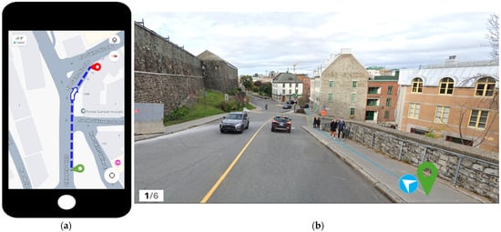
Figure 1.
Example of the images for a downward slope navigation situation: (a) map or image of the route and route environment; (b) animation showing movement along the route.
For each navigation situation, five route instruction formulations were proposed (see Section 2.2.2 for details). Participants rated their agreement with each formulation on a 7-point Likert scale from “Strongly Disagree” (1) to “Strongly Agree” (7) according to the criteria of clarity, completeness, adaptivity, and safety. This scale was chosen to provide sufficient sensitivity to detect subtle differences in agreement while ensuring ease of interpretation and reliability [44]. Figure 2 presents the question assessing participants’ agreement with the proposed formulations for a downward slope navigation situation. The order of response options (i.e., formulations) was randomized to reduce the probability of subjective biases among navigation situations. Participants could also provide comments on clarity, completeness, adaptivity, and safety assurance of these formulations for navigation. Figure 1 illustrates an example of a downward slope navigation situation.
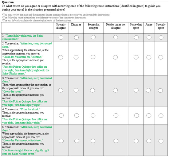
Figure 2.
Question assessing participants’ agreement with the proposed route instruction formulations for the downward slope navigation situation.
Finally, participants’ agreement with different sensory modalities for communicating route instructions was evaluated. Four videos demonstrating different combinations of visual (text, arrow, and map), vocal, vibration, and audible beep modalities were presented for the upward slope navigation situation. The vocal prompts delivered the adapted route instruction text and were produced to simulate realistic navigation messages. Vibration or audible beeps were used specifically to signal accessibility and safety alerts. Participants rated their agreement with the combinations on the same 7-point Likert scale. Figure 3 shows the question to evaluate participants’ agreement with the combined visual and vocal modalities. This evaluation was motivated by the importance of vocal and multimodal instructions for safe, hands-free wheelchair navigation [23]. Participants could also provide optional comments.
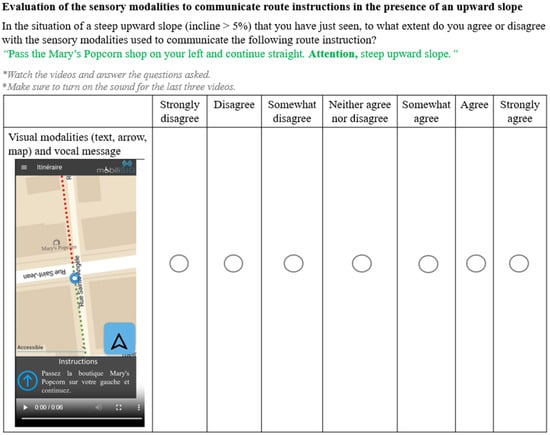
Figure 3.
Question evaluating participants’ agreement with the combination of visual and vocal modalities to communicate the route instructions.
2.4. Data Analysis
The collected sociodemographic and profile-related data were analyzed using mean and standard deviation (SD) for continuous variables and frequency/% for ordinal data.
General agreement ratings with the proposed route instruction formulations were examined. To analyze the difference between the participants’ ratings to these formulations across all fourteen navigation situations, a linear mixed model (LMM) [45], as the main LMM in this study, was applied. This statistical model was chosen because it accounts for the repeated-measures design, in which the same individuals evaluated multiple navigation situations, resulting in interdependent data. This model included a random effect for participants to account for within-subject correlations. Fixed effects comprised route instructions’ formulation types, navigation situations, and their interaction. The homogeneity and normality assumptions for the LMM were checked by inspecting residual plots.
Since users’ characteristics can influence navigational behavior, needs, and preferences for navigation aids [46,47,48], we examined the impact of participants’ profiles and sociodemographic backgrounds on the agreement ratings to the formulations. To conduct these analyses, we applied additional LMMs. In each model, the interaction between formulation type and one predictor variable (e.g., sociodemographic characteristics including gender, experience with a wheelchair, etc., or confidence) was added to the main LMM model as a fixed effect.
In addition, general agreement ratings with the four combinations of communication modalities for the route instructions were analyzed. Because the ratings were not normally distributed, according to the Shapiro–Wilk test, the Friedman test [49] was used to evaluate differences in ratings for these combinations. When significant effects were identified, post hoc pairwise comparisons were performed using Wilcoxon signed-rank tests [49] with Bonferroni correction.
Finally, a qualitative analysis of participants’ questionnaire comments was conducted to better understand the quality and information components of the proposed route instruction formulations and the communication modalities.
3. Results
This section presents participants’ characteristics, ratings of the proposed route instruction formulations across navigation situations, the impact of participant characteristics on these ratings, evaluation of communication modalities, and participant comments.
3.1. Participants’ Characteristics
Thirty-two wheelchair users (19 men and 13 women) with different characteristics participated in this online questionnaire. Table 4 provides an overview of the participants’ sociodemographic data. As for participants’ profile information, Table 5 presents the mean confidence levels reported by participants when facing accessibility and safety challenges across 14 navigation situations. Confidence varied depending on participants’ profiles and their perceived capability to manage each navigation situation. Going up or down a curb, holes, and snow received the lowest mean confidence scores, while generally higher confidence was reported for narrow sidewalks, pressing the pedestrian light button and crossing, intersections without a pedestrian light, and steep downward slopes. Despite higher averages, confidence levels varied widely across participants.
Table 4.
The sociodemographic characteristics of the participants.
Table 5.
The mean confidence scores (measured on a 0–100 scale) of the participants in the 14 selected navigation situations involving accessibility and safety challenges.
3.2. Evaluation of the Route Instruction Formulation Ratings in Different Navigation Situations
Descriptively, formulation ratings of 5, 6, and 7 accounted for 60% of responses, indicating a strong agreement with the formulations. In contrast, lower ratings, particularly 1, 2, and 3, represented only about 22% of responses (see Figure 4). As shown in Table 6, the first formulation, TBT + SN, has a lower median, while the other formulations have medians of 5 and 6. Mode values show that TBT + SN and DTBT + LM were mostly rated 4 (i.e., neither agree nor disagree), while the detailed formulations were mostly rated 6. The adapted and enriched formulations show lower variability (IQR = 2) than TBT + SN and DTBT + LM (IQR = 3).
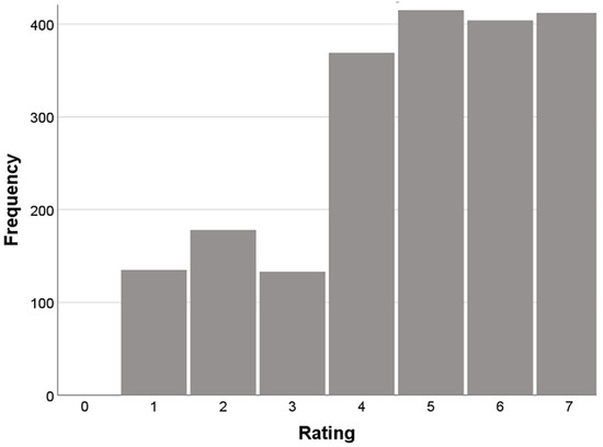
Figure 4.
Histogram of all formulations’ ratings, based on a 7-point Likert scale from 1 to 7.
Table 6.
Descriptive statistics for the proposed formulations, based on a 7-point Likert scale from 1 to 7.
The LMM analysis revealed a statistically significant main effect of formulation on agreement ratings (F(4, 1950) = 26.34, p < 0.01). According to Table 7, the post hoc Bonferroni-adjusted comparisons revealed that the enriched formulations, DTBT + SN + LM + Alert, DTBT + LM + Alert, and DTBT + SN + Alert, were rated significantly higher than TBT + SN and DTBT + LM (all p < 0.001). DTBT + LM was, in turn, rated significantly higher than TBT + SN (p = 0.04). No statistically significant differences were found among the top-rated enriched formulations, DTBT + SN + LM + Alert, DTBT + LM + Alert, and DTBT + SN + Alert (p ≥ 0.34).
Table 7.
Pairwise comparisons of the route instruction formulations based on the main LMM in different navigation situations (Bonferroni-corrected).
The agreement ratings to formulations did not significantly vary across different navigation situations (F(48, 1950) = 1.09, p = 0.30). To further investigate whether the effect of route instructions’ formulations with alerts and without alerts on ratings varied across fourteen navigation situations, the five route instruction formulations in the LMM were categorized into two formulations: detailed route instruction formulations with alerts (i.e., DTBT + LM + Alert, DTBT + SN + LM + Alert, and DTBT + SN + Alert) and the formulations without alerts (i.e., TBT + SN and DTBT + LM). Then, the LMM analysis revealed a significant interaction between these two formulations and navigation situations, F(13, 1988) = 2.27, p < 0.01. According to Table 8, pairwise comparisons with Bonferroni correction indicated that formulations including alerts received significantly higher agreement ratings than those without alerts in most navigation situations (p < 0.03), except for crowded sidewalk (p = 0.09), cross slope (p = 0.18), and route with tree roots and rocks (p = 0.11).
Table 8.
Pairwise comparisons of formulations with alert () and without alerts () for different navigation situations (Bonferroni-corrected).
3.3. Impact of Participants’ Characteristics on the Instruction Formulation Ratings
The LMMs analysis showed that neither the distance participants could independently propel their wheelchairs (F(15, 121.06) = 0.76, p = 0.71) nor the daily frequency of outdoor wheelchair use (F(10, 125.62) = 1.09, p = 0.37) had a significant effect on the route instruction formulation ratings. The LMM analysis indicated a significant interaction between wheelchair type and formulation ratings (F(5, 141.18) = 8.11, p < 0.001), while post hoc tests showed a significant difference only for the TBT + SN formulation, with no significant differences observed for the other formulations. In contrast, significant effects were observed for other participant characteristics, including gender, wheelchair use experience, daily outdoor wheelchair use duration, and profiles. These results are explained in the following and summarized in Table 9 and Table 10.
Table 9.
Significant impacts of participants’ characteristics on the instruction formulation ratings based on the LMMs analysis with Bonferroni-corrected post hoc comparisons.
Table 10.
Significant differences in the instruction formulation ratings across participant characteristics subgroups based on the LMMs analysis with Bonferroni-corrected post hoc comparisons.
- Impact of gender on the instruction formulation ratings
The LMM revealed a significant interaction effect between five route instructions’ formulations and gender on the ratings (F(5130.12) = 8.66, p < 0.01). According to Table 9, post hoc comparisons (with Bonferroni correction) showed that women rated the most enriched formulation, DTBT + SN + LM + Alert, significantly higher than men (Mean difference = 0.90, p = 0.01). For all other formulations, no statistically significant gender differences in ratings were found (all p > 0.09).
- Impact of wheelchair using experience on the instruction formulation ratings
In the LMM, years of wheelchair experience were categorized into two groups: 1–5 years and 6+ years, based on the observed distribution of participants’ experience and a clear shift in rating behavior across experience levels. The results of the LMM revealed a significant interaction between route instruction formulations and experience with a wheelchair (F(5, 111.23) = 7.26, p < 0.01). As shown in Table 10, post hoc comparisons (with Bonferroni correction) showed that participants with more years of wheelchair use (6+ years) gave significantly higher agreement ratings to more detailed formulations, DTBT + SN + LM + Alert and DTBT + SN + Alert, than the 1–5 years group (all p < 0.05). According to Table 10, within the 6+ years group, more enriched formulations, DTBT + SN + LM + Alert, DTBT + SN + Alert and DTBT + LM + Alert, were rated significantly higher than TBT + SN, and DTBT + LM (all p < 0.01). In contrast, no significant differences were observed between formulations ratings for the 1–5 years group, and their ratings remained relatively lower across all formulation types. This suggests that participants with greater wheelchair experience (6+ years) may develop strong anticipatory navigation strategies to manage various obstacles along the route, monitor safety, and maintain increased awareness of the environment and environmental risks. By contrast, users with less experience may be less able to anticipate environmental risks and may have fewer advanced plans to manage obstacles. The higher ratings given by more experienced wheelchair users to the more enriched formulations likely reflect a greater preference for wayfaring information, including alerts and information about safety-critical situations, such as street crossings, which support safer navigation, particularly in unfamiliar environments.
- Impact of daily outdoor wheelchair use duration on the instruction formulation ratings
In the LMM analysis, a significant interaction was observed between five formulations and daily wheelchair using duration outdoors on the agreement ratings (F(20, 116.51) = 7.94, p < 0.01). Post hoc comparisons (Bonferroni-corrected) showed no significant differences in ratings for wheelchair users with 0–14 min of daily use. This subgroup included only one participant and was therefore not interpreted statistically. Longer-duration wheelchair users preferred more detailed route instructions (see Table 10). Indeed, in the 15–29 min and 30–44 min groups, formulations including Alerts, LMs and/ or SNs (i.e., DTBT + SN + LM + Alert, DTBT + SN + Alert, and DTBT + LM + Alert) were rated significantly higher than TBT + SN (p < 0.05). This pattern strengthened in the 45–59 min group, where these enriched formulations were rated significantly higher than both TBT + SN (p < 0.04) and DTBT + LM (p < 0.05). Finally, among participants using a wheelchair outdoors for more than 60 min per day, this trend persisted (Mean differences > 0.9, p < 0.01). In this group, DTBT + LM was also rated significantly more than TBT + SN (p < 0.01).
- Impact of participants’ profiles (confidence level) on the formulation ratings
In the LMM, the confidence scores were categorized into five classes: very low (0–20), low (20>–40), medium (40>–60), high (60>–80), and very high (80>–100) [50]. The results of the LMM showed that the interaction of Confidence levels and formulations had a significant main effect on the ratings (F(20,1934.89) = 1.60, p = 0.04). According to Table 10, the post hoc comparisons (with Bonferroni correction) indicated that across various confidence levels, participants generally agreed with route instruction formulations including Alerts, LMs or/and SNs rather than TBT + SN (p < 0.04).
3.4. Evaluation of Agreement with Sensory Modalities for Communicating Route Instructions
Table 11 presents participants’ agreement ratings (on a 7-point Likert scale from 1 = completely disagree to 7 = completely agree) for the combinations for sensory modalities (Visual, Visual + Vocal, Visual + Vocal + Vibration, and Visual + Vocal+ Audible beep) used to communicate the route instructions. Descriptively, the richer Visual + Vocal + Audible beep modality received the highest mean agreement rating (Mean = 5.80, SD = 1.40), followed closely by Visual + Vocal (Mean = 5.45, SD = 1.69) and Visual + Vocal + Vibration (Mean = 5.32, SD = 1.62). In contrast, the Visual modality was rated lowest on average (Mean = 4.58) and showed slightly higher variability (SD = 1.82) than the other modalities.
Table 11.
Descriptive statistics for sensory modalities for receiving the route instructions, based on a 7-point Likert scale from 1 to 7.
The Friedman test revealed a significant difference among ratings to combinations of modalities (χ2(3) = 16.82, p = 0.001). Post hoc Wilcoxon signed-rank test (with Bonferroni correction) revealed that the combination of Visual and Vocal modalities (Z = −2.93, p < 0.01) and Visual, Vocal, and Audible beep modalities (Z = −2.89, p < 0.01) were both rated significantly higher than the Visual modality (see Table 12). No other pairwise differences were statistically significant.
Table 12.
Significant differences between combinations of the sensory modalities for receiving route instructions based on the pairwise Wilcoxon signed-rank test (with Bonferroni correction).
For further investigation, separate Friedman tests were performed to assess whether modality preferences differed by wheelchair type, based on ratings from manual and motorized wheelchair users. The test was not significant for motorized wheelchair users (χ2(3) = 6.65, p = 0.08). In contrast, manual wheelchair users showed a significant difference across modality combinations (χ2(3) = 10.48, p = 0.01). Post hoc Wilcoxon tests with Bonferroni correction showed that Visual and Vocal modalities (Z = −2.28, p = 0.02) and Visual, Vocal, and Audible beep modalities (Z = −2.12, p = 0.03) were rated significantly higher than only Visual instructions.
3.5. Participants’ Comments
Comments were grouped into two categories: (1) information components of the proposed route instructions, and (2) sensory modalities to communicate the instructions. As comments were optional, the results reflect feedback from 44% of participants. The following presents the results for each theme.
According to the participants’ comments on the information components of the proposed route instructions, 9 participants provided positive feedback for alerts, LMs, and SNs, particularly highlighting their combinations’ clarity, completeness, adaptability, and safety. Positive comments on the use of LMs to enrich instructions (n = 5), combining LMs with SNs (n = 3) for aiding orientation and confirmation, and the importance of SNs for the clarity and completeness of the route instructions (n = 2) were provided by several participants. In contrast, a few participants criticized the LMs in a few navigation situations. For example, a participant noted the poor visibility of the LM (i.e., the museum billboard placed too high for easy visibility) in the crowded sidewalk situation, leading to lower ratings to LM-based formulations in this situation.
Regarding alerts, 9 participants explicitly expressed a preference for receiving alerts about accessibility and safety challenges, highlighting their usefulness in ensuring safety, reducing stress, avoiding unexpected obstacles, and improving preparation. Surface conditions, including cracks, cobblestones, holes, gravel, grass, and narrow sidewalks, were the most frequently noted situations where alerts were considered useful. Dynamic obstacles (i.e., crowded sidewalks and snow accumulation) were mentioned as more difficult to capture reliably (n = 2), and the alert for the cross slope situation was perceived as less useful (n = 3). Several participants requested detailed alerts for specific navigation situations, like the grassy terrain situation (information on grass conditions (e.g., flat or uneven, dry or wet) requested by n = 3) and the snow situation (information on the condition and slope of the surface under snow requested by n = 2).
15% of participants who commented on sensory modalities for communicating route instructions preferred multimodal route instructions. Vocal guidance was considered especially helpful because it supported hands-free operation, which is important for their safety during navigation. One participant valued vibration alerts in noisy environments, while another found them unreliable because they could go unnoticed. Two participants also gave positive feedback on the use of audible beeps as a supplementary modality to improve awareness and comprehension.
4. Discussion
This section discusses the most adapted information components and route instruction formulations, the impact of wheelchair users’ characteristics on their agreement with the formulations, sensory modalities for receiving route instructions, and the study’s strengths, limitations, and future work.
4.1. Combining Wayfinding and Wayfaring Information for the Most Adapted Route Instruction Formulations for Wheelchair Users
Our findings revealed that TBT route instructions provided by mainstream navigation technologies like Google Maps, which lack wayfaring information, were the least preferred option (Mean = 4.25, SD = 1.9) across all navigation situations evaluated in this study. Even when these instructions were supplemented with LMs instead of SNs and with non-turning actions (i.e., street crossings and continuing straight), they still did not meet the needs of wheelchair users who participated in this study and received lower agreement ratings (Mean = 4.55, SD = 1.7) than the more detailed formulations that incorporated alerts, among others. In contrast, formulations offering a higher level of detail, which combine both wayfinding and wayfaring information (DTBT + SN + LM + Alert, DTBT + SN + Alert, and DTBT + LM + Alert), were the most preferred across various navigation situations (Mean = 4.92–5.16, SD = 1.6–1.7, all p < 0.001). This result is in line with our hypothesis H1. These route instructions involve spatial information for wayfinding to find the direction of travel and orient and confirm the route and wayfaring information (e.g., alerts and non-turning actions like street crossings) that supports safe movement through the environment. Participants’ comments further highlighted the clarity, completeness, and adaptivity of these detailed formulations, as well as their help in ensuring security and safety during navigation. These findings confirm the importance of wayfaring information for the navigation of wheelchair users, particularly in unfamiliar urban settings, as highlighted in several previous studies [21,34,51].
Wheelchair users with different profiles require and prefer enriched and adapted route guidance that includes TBT route instructions, LMs and/or SNs, Alerts on route accessibility and safety challenges, and non-turning actions. Including LMs and/or SNs in adapted route instructions helps wheelchair users orient themselves and confirm their route, with several wheelchair users who participated in our study noting that using both cues strengthened confirmation and reduced navigation errors. These errors can be especially risky for wheelchair users, as they may lead to unsafe actions, rerouting, and demanding travel. This aligns with prior findings that highlight the value of LMs in improving confidence and navigation performance [32,33]. In addition, guidance on street crossings is essential for wheelchair users’ safety, as it helps identify crossing locations (especially when visibility is limited by obstacles such as upward slopes) and indicates which side of the street to follow afterward, where accessibility may differ. This importance has been highlighted in previous research work [21,25]. Similarly, providing continuing straight guidance can help with reorientation and route confirmation.
Regarding the alerts, higher agreement was observed for route instruction formulations including alerts in most navigation situations (11 out of 14), compared to those without alerts (all p < 0.03), a finding also highlighted in participants’ comments. The importance of alerts for safety and security has also been emphasized in previous research [8,24,37,38]. While participants required alerts for poor surface quality (e.g., cobblestones, uneven sidewalks, and holes), the ratings for alert-based formulations for paths with tree roots and rocks, crowded sidewalks, and cross slopes did not differ significantly from those of the non-alert formulations (p = 0.09–0.18). This finding is also reflected in participants’ comments. This should be investigated further using a larger and more diverse group of participants.
4.2. Relation Between Wheelchair Users’ Characteristics and Formulation Ratings
We have observed a significant impact of participants’ sociodemographic data on their route instruction formulation ratings across navigation situations, consistent with our hypothesis H2. The women rated the most enriched instruction formulations, which included both wayfinding and wayfaring information, higher than men (p < 0.01), consistent with prior research on gender differences in navigation aids preferences [46,47]. Prior studies, like [52,53], reported that women generally, experience higher spatial anxiety and more concern about getting lost, which may increase the importance of confirmatory and safety-related cues. Confirmatory information has been shown to reduce confusion during navigation [41], which may be useful in situations with heightened perceived risks. For women wheelchair users, who encounter more significant accessibility and safety challenges than the general population, having information on route confirmation and accessibility and safety challenges may be even more helpful. Additionally, women tend to depend more on LMs for navigation [54], which aligns with our findings that more detailed instructions, including LM information, are more preferred.
Participants with greater wheelchair experience (6+ years group) and different daily outdoor wheelchair use duration showed significantly higher agreement with detailed instructions that included DTBT, Alerts, SNs, and LMs (p < 0.05). This finding aligns with previous findings [55] that more experienced wheelchair users tend to prioritize wayfaring information during navigation. No significant effects were found for daily frequency, wheelchair use distance, or wheelchair type, indicating the need for further research with larger and more diverse samples.
Although we expected wheelchair users’ profiles to affect ratings of the proposed route instructions (our hypothesis H2), as they may face obstacles differently depending on their profiles and capabilities, our findings revealed that enriched instruction formulations were consistently rated higher by most participants. This shows that additional investigation involving a larger group of wheelchair users with varied profiles is required.
4.3. Sensory Modalities for Communicating Route Instructions to Wheelchair Users
Our findings on the sensory modalities for communicating route instructions revealed that wheelchair users preferred multimodal route instructions, particularly the combination of visual and vocal communications with audible beeps, as well as visual and vocal combinations (all p < 0.01), confirming our hypothesis H3. Participants also preferred audible beeps and vibrations rather than visual indications to signal potential accessibility and safety hazards (all p < 0.05). These findings were observed particularly among manual wheelchair users, while the preferences among motorized wheelchair users require further investigation using a larger sample. High agreement with multimodal delivery likely reflects the need for manual wheelchair users to use their hands to drive their wheelchairs while monitoring the route for safety and accessibility. Relying on visual indications on a mobile screen can therefore distract them from the environment and increase safety risks. Multimodal communication can reduce this challenge by enabling hands-free navigation and supporting physical safety. In this way, vocal guidance may complement visual information, and auditory and haptic alerts can signal hazards, improving situational awareness and supporting safer wayfinding and wayfaring. These findings suggest that ensuring physical safety during navigation should be considered a critical factor in the design of navigation interfaces and their communication modalities for manual wheelchair users’ mobility. As this study conducted an initial evaluation of agreement levels across modality combinations, further examination with a larger sample, including wheelchair users with diverse characteristics (e.g., wheelchair types) and across diverse navigation situations, is needed to better understand wheelchair users’ preferences for communication modalities and their safety demands.
4.4. Strengths and Limitations of the Study and Future Work
This study identified the importance of adapted, detailed route instruction formulations that combine wayfaring and wayfinding information for wheelchair users to support their navigational needs across different navigation situations, using an online questionnaire (i.e., a subjective data collection method). This presents the main contribution of this study, since the route instructions of common navigation technologies (e.g., Google Maps) have limitations in meeting the needs of wheelchair users and their mobility. In addition, this study revealed significant impacts of several characteristics of wheelchair users and navigation situations on their agreement with the adapted and enriched route instructions, highlighting other contributions of this study. Furthermore, this study makes an additional contribution by demonstrating high agreement with multimodal route instruction for wheelchair users.
Although using the online questionnaire to assess wheelchair users’ agreement level with the route instruction formulations provides several advantages, such as controlled variables and easier recruitment, particularly for wheelchair users, it also presents limitations. In addition, recruiting participants for an online survey is more challenging among wheelchair users than in the general population, due to the smaller population of eligible participants. Moreover, designing the questionnaire that covered multiple factors, like common accessibility challenges, navigation actions (turning, continuing, and street crossings), and user characteristics, while remaining concise and easy to complete, was challenging. Additionally, despite efforts to reproduce real-world conditions with Google Maps images and GIF animations in the questionnaire, participants could not experience a full 360° view of the environment. Their perceptions of the images sometimes influenced their judgments of navigation situations and agreement level with route instructions. Some of these concerns, although valid in the questionnaire, may not arise in real-world navigation. More broadly, the questionnaire assesses participants’ perceived agreement with route instruction formulations and communication modalities, rather than behavior observed during real navigation. Consequently, statistically significant results may not always reflect meaningful practical effects. These findings should therefore be validated by objective measurements (e.g., navigation performance) in real-world navigation situations in future studies. In addition, this study did not examine the influence of environmental factors, such as the complexity of route decision points, on wheelchair users’ preferences for navigational aids. It also did not consider how the trip purpose (e.g., leisure versus time-constrained travel) may affect these preferences. Furthermore, secondary disabilities (e.g., visual or cognitive disabilities) were not controlled during participants’ recruitment, which may have influenced their preferences for adapted route instructions. Investigating these factors may provide a more comprehensive understanding of wheelchair users’ navigational needs and help better adapt assistive navigation tools to address them.
In this study, we used LMMs, which are powerful for repeated-measures designs to examine interaction effects. The sample size is 32 wheelchair users, each providing 70 repeated observations, with a total of about 2240 observations. Previous research on repeated-measures designs indicates that stable estimation of fixed effects is generally supported by about 30–50 participants and 30–50 repeated observations per participant, depending on the magnitude of the effects and the data variability [56,57,58], which aligns with the present study. However, some differences in agreement ratings for three route instruction formulations (DTBT + SN + LM + Alert, DTBT + LM + Alert, and DTBT + SN + Alert) across navigation situations may not have reached statistical significance. This may be due to the complexity of the interaction effects and the lack of individual variability in responses. Additionally, no significant relation was observed between frequency or distance of using a wheelchair and participants’ ratings for the instruction’s formulations. Further research with larger and more diverse samples of wheelchair users is needed to detect small-to-moderate effects, particularly for interaction effects.
As a perspective, the findings of this study on preferred information components and formulations for adapted route instructions will be used to develop a conceptual model for generating adapted route instructions for wheelchair users. This conceptual model will inform the development of a route-instruction generation tool, which will be integrated into MobiliSIG (https://mobilisig.ffgg.ulaval.ca/, accessed on 1 December 2024) [59]. MobiliSIG is a multimodal assistive navigation technology designed to assist the mobility of people with mobility disabilities in urban environments. These adapted route instructions in MobiliSIG will then be evaluated through a usability study conducted in real navigation situations, where participants will receive these instructions during navigation.
5. Conclusions
This study aimed to identify the most adapted route instructions for wheelchair users to guide them efficiently while navigating urban environments with different accessibility and safety challenges. This study also examined the impact of participants’ sociodemographic and profile information on their choices of the route instructions and assessed their choices of sensory modality for receiving the route instructions. To this end, we conducted an online survey using a questionnaire with 32 participants to collect their sociodemographic data and profiles, as well as their agreement ratings with five proposed route instruction formulations (different combinations of information components like turn-by-turn instructions, landmarks, and accessibility information) across 14 navigation situations that encompass common accessibility and safety challenges. Their ratings for the formulations considered clarity, sufficiency, adaptability, and safety criteria. We also gathered their agreement level with the sensory modalities and their comments through the questionnaire. Quantitative data were analyzed statistically, and participants’ comments were examined qualitatively.
Our findings revealed that wheelchair users need adapted and detailed route instructions that integrate both wayfinding and wayfaring information. Compared with standard turn-by-turn guidance often used in current assistive navigation tools, wheelchair users with different profiles had greater agreement with adapted instructions. These instructions enriched turn-by-turn guidance with environmental cues for orientation and route confirmation, non-turning actions, and accessibility and safety information. Indeed, landmarks and/or street names helped with orientation and route confirmation. Street crossings can help identify crossing locations and determine the correct side of the street, thereby supporting safer navigation. In most navigation situations (e.g., slopes, poor surface quality, narrow sidewalks, and intersections without pedestrian lights), alert-based detailed formulations were significantly preferred because they provide advance warning and better prepare users to efficiently handle accessibility and safety challenges. Women and participants with greater wheelchair experience, possibly due to increased environmental awareness, expressed stronger agreement with enriched and adapted route instructions. The preference for multimodal delivery highlights that adapted route guidance also needs to meet the sensory demands of wheelchair mobility to support safer mobility.
Ultimately, the findings of this research will be used to develop more adaptive route instruction generation tools for wheelchair users, addressing their specific needs and efficiently guiding them during navigation. These adapted route instructions may help wheelchair users navigate more safely and confidently. This may lead to more inclusive and sustainable mobility, ultimately improving their social integration and autonomy.
Author Contributions
Conceptualization, Sanaz Azimi and Mir Abolfazl Mostafavi; Data curation, Sanaz Azimi; Formal analysis, Sanaz Azimi; Funding acquisition, Sanaz Azimi and Mir Abolfazl Mostafavi; Investigation, Sanaz Azimi; Methodology, Sanaz Azimi and Mir Abolfazl Mostafavi; Project administration, Mir Abolfazl Mostafavi; Resources, Mir Abolfazl Mostafavi; Software, Sanaz Azimi and Angélique Montuwy; Supervision, Mir Abolfazl Mostafavi, Krista L. Best and Aurélie Dommes; Validation, Sanaz Azimi, Mir Abolfazl Mostafavi, Krista L. Best, Aurélie Dommes and Angélique Montuwy; Writing—original draft, Sanaz Azimi; Writing—review and editing, Sanaz Azimi, Mir Abolfazl Mostafavi, Krista L. Best, Aurélie Dommes and Angélique Montuwy. All authors have read and agreed to the published version of the manuscript.
Funding
This research was funded by the Canada Research Chairs Program (grant number CRC-2022-00112). The authors also acknowledge partial funding from the Natural Sciences and Engineering Research Council of Canada (grant number RGPIN-2023-05745), the Ministère de l’Économie et de l’Innovation (MEI) du Québec (grant number 2021-2022 #57256), Center for Interdisciplinary Research in Rehabilitation and Social Integration (Cirris), and the Social Participation and Inclusive City research group (PSVI).
Data Availability Statement
The datasets produced and examined in this study through the online survey cannot be shared to protect the privacy and consent of research participants.
Conflicts of Interest
No potential conflict of interest was reported by the authors.
Abbreviations
The following abbreviations are used in this paper:
| POI | Points of Interest |
| TBT | Turn-By-Turn instructions |
| DTBT | Detailed Turn-By-Turn instructions |
| LM | LandMark |
| SN | Street Name |
| SD | Standard Deviation |
| SE | Std. Error |
| LMM CI | Linear Mixed Model Confidence Interval |
References
- World Health Organization. Disability. Available online: https://www.who.int/news-room/fact-sheets/detail/disability-and-health (accessed on 20 October 2025).
- World Health Organization. Strengthening Access to Appropriate Wheelchairs. Available online: https://www.who.int/teams/health-product-policy-and-standards/assistive-and-medical-technology/assistive-technology/wheelchair-services (accessed on 20 October 2025).
- Statistics Canada. Canadian Survey on Disability (CSD). Available online: https://www150.statcan.gc.ca/n1/pub/11-627-m/11-627-m2023063-eng.htm (accessed on 20 October 2025).
- Smith, E.M.; Giesbrecht, E.M.; Ben Mortenson, W.; Miller, W.C. Prevalence of Wheelchair and Scooter Use Among Community-Dwelling Canadians. Phys. Ther. 2016, 96, 1135–1142. [Google Scholar] [CrossRef]
- Bennett, S.; Lee Kirby, R.; MacDonald, B. Wheelchair Accessibility: Descriptive Survey of Curb Ramps in an Urban Area. Disabil. Rehabil. Assist. Technol. 2009, 4, 17–23. [Google Scholar] [CrossRef]
- Millington, C.; Ward Thompson, C.; Rowe, D.; Aspinall, P.; Fitzsimons, C.; Nelson, N.; Mutrie, N. Development of the Scottish Walkability Assessment Tool (SWAT). Health Place 2009, 15, 474–481. [Google Scholar] [CrossRef]
- Giesbrecht, E.; Ripat, J.; Cooper, J.; Quanbury, A. Experiences with Using a Pushrim-Activated Power-Assisted Wheelchair for Community-Based Occupations: A Qualitative Exploration. Can. J. Occup. Ther. 2011, 78, 127–136. [Google Scholar] [CrossRef]
- Prescott, M.; Miller, W.C.; Borisoff, J.; Tan, P.; Garside, N.; Feick, R.; Mortenson, W. Ben An Exploration of the Navigational Behaviours of People Who Use Wheeled Mobility Devices in Unfamiliar Pedestrian Environments. J. Transp. Health 2021, 20, 100975. [Google Scholar] [CrossRef]
- Kapsalis, E.; Jaeger, N.; Hale, J. Disabled-by-Design: Effects of Inaccessible Urban Public Spaces on Users of Mobility Assistive Devices–a Systematic Review. Disabil. Rehabil. Assist. Technol. 2024, 19, 604–622. [Google Scholar] [CrossRef] [PubMed]
- Fougeyrollas, P.; Cloutier, R.; Bergeron, H.; St-Michel, G. The Quebec Classification: Disability Creation Process; International Network on the Disability Creation Process: Québec City, QC, Canada, 1998. [Google Scholar]
- Li, C. User Preferences, Information Transactions and Location-Based Services: A Study of Urban Pedestrian Wayfinding. Comput. Environ. Urban Syst. 2006, 30, 726–740. [Google Scholar] [CrossRef]
- Ishikawa, T.; Fujiwara, H.; Imai, O.; Okabe, A. Wayfinding with a GPS-Based Mobile Navigation System: A Comparison with Maps and Direct Experience. J. Environ. Psychol. 2008, 28, 74–82. [Google Scholar] [CrossRef]
- Krukar, J.; Anacta, V.J.; Schwering, A. The Effect of Orientation Instructions on the Recall and Reuse of Route and Survey Elements in Wayfinding Descriptions. J. Environ. Psychol. 2020, 68, 101407. [Google Scholar] [CrossRef]
- Parush, A.; Ahuvia, S.; Erev, I. Degradation in Spatial Knowledge Acquisition When Using Automatic Navigation Systems. In International Conference on Spatial Information Theory; Lecture Notes in Computer Science; Springer: Berlin/Heidelberg, Germany, 2007; Volume 4736, pp. 238–254. [Google Scholar] [CrossRef]
- Gardony, A.L.; Brunyé, T.T.; Taylor, H.A. Navigational Aids and Spatial Memory Impairment: The Role of Divided Attention. Spat. Cogn. Comput. 2015, 15, 246–284. [Google Scholar] [CrossRef]
- Dethlefs, N.; Wu, Y.; Kazerani, A.; Winter, S. Generation of Adaptive Route Descriptions in Urban Environments. Spat. Cogn. Comput. 2011, 11, 153–177. [Google Scholar] [CrossRef]
- Anacta, V.J.A.; Schwering, A.; Li, R.; Muenzer, S. Orientation Information in Wayfinding Instructions: Evidences from Human Verbal and Visual Instructions. GeoJournal 2017, 82, 567–583. [Google Scholar] [CrossRef]
- Dale, R.; Geldof, S.; Prost, J.P. Using Natural Language Generation in Automatic Route Description. J. Res. Pract. Inf. Technol. 2005, 37, 89–105. [Google Scholar]
- Michel, D.; Ariane, T. Assisting Pedestrian Wayfinding in Urban Settings. In Applied Spatial Cognition: From Research to Cognitive Technology; Psychology Press: Hove, UK, 2020; pp. 25–52. [Google Scholar]
- Richter, K. Context-Specific Route Directions: Generation of Cognitively Motivated Wayfinding Instructions; IOS Press: Amsterdam, The Netherlands, 2008; Volume 314. [Google Scholar]
- Vincent, C.; Girard, R.; Dumont, F.; Archambault, P.; Routhier, F.; Mostafavi, M.A. Evaluation of Satisfaction with Geospatial Assistive Technology (ESGAT): A Methodological and Usability Study. Disabil. Rehabil. Assist. Technol. 2022, 17, 134–151. [Google Scholar] [CrossRef]
- Gupta, M.; Abdolrahmani, A.; Edwards, E.; Cortez, M.; Tumang, A.; Majali, Y.; Lazaga, M.; Tarra, S.; Patil, P.; Kuber, R.; et al. Towards More Universal Wayfinding Technologies: Navigation Preferences across Disabilities. In Proceedings of the 2020 CHI Conference on Human Factors in Computing Systems, Honolulu, HI, USA, 25–30 April 2020. [Google Scholar] [CrossRef]
- Prémont, M.É.; Vincent, C.; Mostafavi, M.A. Geospatial Assistive Technologies: Potential Usability Criteria Identified from Manual Wheelchair Users. Disabil. Rehabil. Assist. Technol. 2020, 15, 844–855. [Google Scholar] [CrossRef]
- Prescott, M.; Labbé, D.; Miller, W.C.; Borisoff, J.; Feick, R.; Mortenson, W. Ben Factors That Affect the Ability of People with Disabilities to Walk or Wheel to Destinations in Their Community: A Scoping Review. Transp. Rev. 2020, 40, 646–669. [Google Scholar] [CrossRef]
- Pecchini, D.; Giuliani, F. Street-Crossing Behavior of People with Disabilities. J. Transp. Eng. 2015, 141, 04015022. [Google Scholar] [CrossRef]
- Schmid, F.; Richter, K.F.; Peters, D. Route Aware Maps: Multigranular Wayfinding Assistance. Spat. Cogn. Comput. 2010, 10, 184–206. [Google Scholar] [CrossRef]
- Mirri, S.; Prandi, C.; Salomoni, P. Personalizing Pedestrian Accessible Way-Finding with MPASS. In Proceedings of the 2016 13th IEEE Annual Consumer Communications and Networking Conference, CCNC 2016; Institute of Electrical and Electronics Engineers Inc.: Las Vegas, NV, USA, 2016; pp. 1119–1124. [Google Scholar]
- Shobana Lakshmi, R.; Muruga Radha Devi, D.; Brindha Devi, V.; Pavithra, B.; Mary Lavanya, W.; Suganthi, B. Wheelmate Pro—A Mobile Application for Disable Ones. In 2025 International Conference on Computing and Communication Technologies, ICCCT 2025; IEEE: New York, NY, USA, 2025. [Google Scholar] [CrossRef]
- Phang, S.H.; Martin Ginis, K.A.; Routhier, F.; Lemay, V. The Role of Self-Efficacy in the Wheelchair Skills-Physical Activity Relationship among Manual Wheelchair Users with Spinal Cord Injury. Disabil. Rehabil. 2012, 34, 625–632. [Google Scholar] [CrossRef] [PubMed]
- Tomko, M.; Winter, S.; Claramunt, C. Experiential Hierarchies of Streets. Comput. Environ. Urban Syst. 2008, 32, 41–52. [Google Scholar] [CrossRef]
- Klippel, A.; Winter, S. Structural Salience of Landmarks for Route Directions. In International Conference on Spatial Information Theory; Lecture Notes in Computer Science (including subseries Lecture Notes in Artificial Intelligence and Lecture Notes in Bioinformatics); Springer: Berlin/Heidelberg, Germany, 2005; Volume 3693, pp. 347–362. [Google Scholar] [CrossRef]
- Richter, K.F.; Winter, S. Landmarks: GIScience for Intelligent Services; Springer: Cham, Switzerland, 2014. [Google Scholar]
- Tom, A.; Denis, M. Referring to Landmark or Street Information in Route Directions: What Difference Does It Make? In International Conference on Spatial Information Theory; Lecture Notes in Computer Science (including subseries Lecture Notes in Artificial Intelligence and Lecture Notes in Bioinformatics); Springer: Berlin/Heidelberg, Germany, 2003; Volume 2825, pp. 362–374. [Google Scholar] [CrossRef]
- Kasemsuppakorn, P.; Karimi, H.A. Personalised Routing for Wheelchair Navigation. J. Locat. Based Serv. 2009, 3, 24–54. [Google Scholar] [CrossRef]
- Gharebaghi, A.; Mostafavi, M.A.; Edwards, G.; Fougeyrollas, P.; Morales-Coayla, P.; Routhier, F.; Leblond, J.; Noreau, L. A Confidence-Based Approach for the Assessment of Accessibility of Pedestrian Network for Manual Wheelchair Users. In Proceedings of the Lecture Notes in Geoinformation and Cartography; Springer: Berlin/Heidelberg, Germany, 2017; pp. 463–477. [Google Scholar]
- Azimi, S.; Mostafavi, M.A.; Lynn Best, K.; Dommes, A. Investigating the Navigational Behavior of Wheelchair Users in Urban Environments Using Eye Movement Data. In International Symposium on Web and Wireless Geographical Information Systems; Lecture Notes in Computer Science; Springer Nature: Cham, Switzerland, 2023; Volume 13912, pp. 57–75. [Google Scholar] [CrossRef]
- Zahabi, M.; Zheng, X.; Maredia, A.; Shahini, F. Design of Navigation Applications for People with Disabilities: A Review of Literature and Guideline Formulation. Int. J. Hum. Comput. Interact. 2023, 39, 2942–2964. [Google Scholar] [CrossRef]
- Murdoch, T.; Pey, T.; Brooks, E. A Step towards Truly Independent Access for Everyone, Everywhere. Assist. Technol. 2022, 34, 668–672. [Google Scholar] [CrossRef] [PubMed]
- Richter, K.F.; Klippel, A. A Model for Context-Specific Route Directions. In Spatial Cognition IV. Reasoning, Action, Interaction; Lecture Notes in Artificial Intelligence (Subseries of Lecture Notes in Computer Science); Springer: Berlin/Heidelberg, Germany, 2005; Volume 3343, pp. 58–78. [Google Scholar] [CrossRef]
- WHO. A Road Safety Manual for Decisionmakers and Practitioners; World Health Organization: Geneva, Switzerland, 2013.
- Mackaness, W.; Bartie, P.; Espeso, C.S.R. Understanding Information Requirements in “Text Only” Pedestrian Wayfinding Systems. In International Conference on Geographic Information Science; Lecture Notes in Computer Science (including subseries Lecture Notes in Artificial Intelligence and Lecture Notes in Bioinformatics); Springer: Cham, Switzerland, 2014; Volume 8728, pp. 235–252. [Google Scholar] [CrossRef]
- Rousell, A.; Zipf, A. Towards a Landmark-Based Pedestrian Navigation Service Using OSM Data. ISPRS Int. J. Geoinf. 2017, 6, 64. [Google Scholar] [CrossRef]
- Rushton, P.W.; Miller, W.C.; Kirby, R.L.; Janice, J. Measure for the Assessment of Confidence with Manual Wheelchair Use (WheelCon-M) Version 2.1: Reliability and Validity. J. Rehabil. Med. 2013, 45, 61–67. [Google Scholar] [CrossRef]
- Krosnick, J.A.; Presser, S. Question and Questionnaire Design; Elsevier: San Diego, CA, USA, 2009. [Google Scholar]
- Nguyen, T.; Jiang, J. Linear and Generalized Linear Mixed Models and Their Applications, 2nd ed.; Springer Series in Statistics; Springer: New York, NY, USA, 2007. [Google Scholar]
- MacFadden, A.; Elias, L.; Saucier, D. Males and Females Scan Maps Similarly, but Give Directions Differently. Brain Cogn. 2003, 53, 297–300. [Google Scholar] [CrossRef]
- Coluccia, E.; Louse, G. Gender Differences in Spatial Orientation: A Review. J. Environ. Psychol. 2004, 24, 329–340. [Google Scholar] [CrossRef]
- De Cock, L.; Ooms, K.; Van de Weghe, N.; Vanhaeren, N.; Pauwels, P.; De Maeyer, P. Identifying What Constitutes Complexity Perception of Decision Points during Indoor Route Guidance. Int. J. Geogr. Inf. Sci. 2021, 35, 1232–1250. [Google Scholar] [CrossRef]
- Field, A.; Field, Z.; Miles, J. Discovering Statistics Using R; Wiley: Hoboken, NJ, USA, 2012. [Google Scholar]
- Gharebaghi, A. Évaluation et la Représentation Spatiotemporelle de L’accessibilité des Réseaux Piétonniers Pour le Déplacement des Personnes à Mobilité Réduite. Ph.D. Thesis, Laval University, Québec, QC, Canada, 2018. [Google Scholar]
- Karimi, H.A.; Zhang, L.; Benner, J.G. Personalized Accessibility Map (PAM): A Novel Assisted Wayfinding Approach for People with Disabilities. Ann. GIS 2014, 20, 99–108. [Google Scholar] [CrossRef]
- Lawton, C.A.; Kallai, J. Gender Differences in Wayfinding Strategies and Anxiety about Wayfinding: A Cross-Cultural Comparison. Sex Roles 2002, 47, 389–401. [Google Scholar] [CrossRef]
- Muffato, V.; Miola, L.; Pazzaglia, F.; Meneghetti, C. Trajectories across the Healthy Adult Lifespan on Sense of Direction, Spatial Anxiety, and Attitude in Exploring Places. Front. Psychol. 2023, 14, 1240873. [Google Scholar] [CrossRef] [PubMed]
- Dong, W.; Zhan, Z.; Liao, H.; Meng, L.; Liu, J. Assessing Similarities and Differences between Males and Females in Visual Behaviors in Spatial Orientation Tasks. ISPRS Int. J. Geoinf. 2020, 9, 115. [Google Scholar] [CrossRef]
- Azimi, S.; Mostafavi, M.A.; Montuwy, A.L.; Best, K.L.; Dommes, A. Wheelchair Users Navigational Behavior: Insights from Eye Movement Data and Environment Legibility. In Proceedings of the Leibniz International Proceedings in Informatics, LIPIcs, 16th International Conference on Spatial Information Theory (COSIT 2024); Schloss Dagstuhl-Leibniz-Zentrum fur Informatik GmbH, Dagstuhl Publishing: Wadern, Germany, 2024; Volume 315. [Google Scholar]
- Meteyard, L.; Davies, R.A.I. Best Practice Guidance for Linear Mixed-Effects Models in Psychological Science. J. Mem. Lang. 2020, 112, 104092. [Google Scholar] [CrossRef]
- Brysbaert, M.; Stevens, M. Power Analysis and Effect Size in Mixed Effects Models: A Tutorial. J. Cogn. 2018, 1, 9. [Google Scholar] [CrossRef]
- Scherbaum, C.A.; Ferreter, J.M. Estimating Statistical Power and Required Sample Sizes for Organizational Research Using Multilevel Modeling. Organ. Res. Methods 2009, 12, 347–367. [Google Scholar] [CrossRef]
- Mostafavi, M. MobiliSIG: Development of a Geospatial Assistive Technology for Navigation of People with Motor Disabilities. In Proceedings of the Spatial Knowledge and Information Conference, Banff, AB, Canada, 27 February–1 March 2015. [Google Scholar]


Disclaimer/Publisher’s Note: The statements, opinions and data contained in all publications are solely those of the individual author(s) and contributor(s) and not of MDPI and/or the editor(s). MDPI and/or the editor(s) disclaim responsibility for any injury to people or property resulting from any ideas, methods, instructions or products referred to in the content. |
© 2026 by the authors. Published by MDPI on behalf of the International Society for Photogrammetry and Remote Sensing. Licensee MDPI, Basel, Switzerland. This article is an open access article distributed under the terms and conditions of the Creative Commons Attribution (CC BY) license.