Abstract
If we take a distance from a map without considering the distortion, we will not get the correct value. We will get the correct value if we take the distortion into account, that is, if we use an expression for distance that does not contain distortion. The article shows how to determine the distance measured along a loxodrome between two points on a sphere if we have an image of the loxodrome in a cylindrical projection. Using the examples of Mercator, equidistant and equal-area projections, a formula was derived that does not depend on the map projection used. This was done with the aim of achieving two goals. The first was that when calculating the distance between two places shown on a map, the distortion inherent in the map due to the applied map projection should be considered. The second goal was to show how, using the theory of map projections, a formula can be derived that does not depend on the applied map projection.
1. Introduction
A map is the result of mapping data usually from the Earth, a celestial body, or an imaginary world into a planar representation on a piece of paper or on a digital screen such as a computer monitor. Maps are usually created by transforming the data first onto a spherical or ellipsoidal surface and then into a plane. Mapping a curved surface into a plane is known as map projection and can take different forms [1].
Since no map projection is isometric, i.e., it does not preserve the correct scale throughout, it is important to be aware of its variation on the map. On a world map, distortion is obvious to the eye familiar with maps. It is usually noted to what extent land masses are of inappropriate size or altered shape, and to what extent meridians and parallels do not intersect at right angles or are not evenly spaced. On maps of countries or even continents, distortion may not be visible to the eye but becomes apparent after careful measurement and analysis [2].
All map projections introduce distortion of area, angles and/or distances. Some types of distortions can be controlled to preserve specific characteristics, but map projections must distort other characteristics of the depicted object. The main problem in cartography is that it is not possible to map a spherical or ellipsoidal surface into a plane without distortion. Euler was the first to prove in 1772 that a sphere cannot be mapped into a plane with distortion equal to zero [3,4].
At the beginning, we notice that every map projection introduces certain distortions. The local length scale factor c serves as a measure of length distortion, which we define as follows for a sphere of radius R [2,5,6]:
where ds is the differential of the arc on the surface being mapped, and ds′ is the corresponding differential of the arc in the projection plane, E, F and G are coefficients defined in this way:
where and are latitude and longitude, respectively, , .
are equations of map projection, or in our case formulas by which a sphere of radius R is mapped, and x and y are the coordinates of a point in a rectangular (mathematical, right-handed) coordinate system in the plane. We will assume that (3) defines a regular mapping, except perhaps at the edges of the interval, i.e., for and .
The formula is usually used to determine the local linear scale factor c, but it can also be used to calculate the arc length of a curve in a projection or to calculate the arc length of a curve on a sphere . In this article, we will demonstrate this using examples of normal aspect cylindrical projections and loxodromes.
For normal aspect cylindrical projections, Equation (3) is simplified to [2,5,6]
and then the expression for the square of the local linear scale factor is simpler
where h and k are the factors of local length scales in the direction of the meridians and parallels, respectively.
2. Loxodrome
Let a sphere of radius R centred at the origin of the coordinate system be defined by the geographic parameterization
where and are latitude and longitude, , . An infinitesimal triangle on a sphere is shown in Figure 1. The arc length differential of a curve is ds, the meridian arc length differential is , and the parallel arc length differential is .
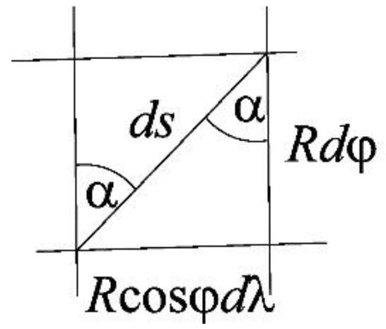
Figure 1.
An infinitesimal triangle on a sphere of radius R, the differential of the arc length of a curve is ds, the differential of the arc length of a meridian is , and the differential of the arc length of a parallel is .
If we assume that ., i.e., that it is a loxodrome, by integrating expression (8) we will obtain the equation of the loxodrome in the form
where and are constants. For simplicity and brevity, we will introduce the isometric width, or the function as follows [5,6]
and from there
Now we can write the equation of the loxodrome (9) in the form
Furthermore, from (10) and (12) for it follows
and then
If the loxodrome passes through the points with coordinates and then
3. Loxodrome in Some Cylindrical Projections
3.1. Loxodrome in the Mercator Projection of the Sphere
The equations of the normal aspect Mercator projection of the sphere are:
where is a constant [2,5,6]. Given (10), we can write these equations in the form
If we substitute the expression for from (12) into (18), we will obtain the equation of the loxodrome in that projection
where it can be easily obtained
Since are constants, (20) represents a linear relationship between x and y, so the graphical representation of relation (20) is a straight line in the projection plane. In other words, the loxodrome image on a map made in the normal aspect Mercator projection is a straight line. If that line passes through two points with coordinates and , then the distance d between those two points in the projection plane is equal to
Due to the distortions that are present in every map projection, we doubt that formula (21) is the true length of the loxodrome on the sphere. If we do not know the formula for calculating the length of the loxodrome on the sphere, we will now derive it by using the theory of map projections.
In the normal aspect Mercator projection, the local linear scale factor c is equal to [2,5,6]
Due to
according to (1) it is true
and after integration, with so that the local linear scale factor would be equal to 1 at the equator,
For example, the length of the loxodrome between New York (, ), and Moscow (, ) with the assumed radius of the Earth’s sphere R = 6370 km is 8283.2 km (Figure 2). The distance d between New York and Moscow on a map drawn in the Mercator projection according to formula (21) is 12,820.7 km. This is the length of the loxodrome image on the map, which is significantly different from the length of the loxodrome on the sphere.
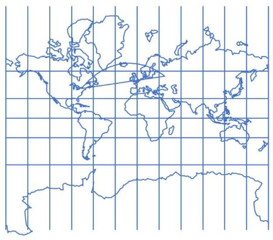
Figure 2.
World map in the normal aspect Mercator projection. The straight line that connects New York and Moscow is the loxodrome, and the curve that connects the two places is the orthodrom. Orthodrome gives the shortest distance between two places on the sphere, so this image can be interpreted as an illusion, but in fact it is a distortion due to map projection.
3.2. Loxodrome in the Equidistant Cylindrical Projection of the Sphere
The equations of the normal aspect equidistant cylindrical projection of a sphere of radius R are
where is a constant [2,5,6]. If we substitute the expression for from (12) into (26), we will obtain the parametric equations of the image of the loxodrome
from which the equation of the image of a loxodrome can easily be obtained in the form
or
Since are constants, (28) or (29) do not represent a linear relationship between x and y, so the graphic representation of the loxodrome image will not be a straight line in the plane of the equidistant cylindrical projection, but some other curve. If the loxodrome passes through points with coordinates and then and are determined by (10).
The distance between two points on the loxodrome image in that projection cannot be obtained by a simple Formula (21). Assuming that so that at the equator the local linear scale factor is equal to 1, the differential of the arc of the image of the loxodrome in the plane of the equidistant cylindrical projection will be:
Integration gives
The value of the integral in (31) can be calculated using some of the numerical integration methods. In addition, it is shown that the solution to this integral can be written using elementary functions as follows:
In this way, we obtained an expression for calculating the length of the arc of the image of a loxodrome in the plane of an equidistant cylindrical projection.
For the normal aspect equidistant cylindrical projection (26) we have [2,5,6]:
Assuming that
and then for points on the loxodrome, taking into account (8)
Now we can write
After integrating expression (36), we obtain (25), which is the formula for calculating the length of a loxodrome arc on a sphere that is independent of the applied map projection and thus free from the distortions that the projection entails.
Figure 3 shows a world map in a normal aspect equidistant cylindrical projection. The almost straight line connecting the points with the coordinates , and , is the image of a loxodrome, and the curve that resembles the letter S, the image of an orthodrome that connects those same two points in the projection. Solving the integral (32) with the radius of the Earth’s sphere R = 6370 km equals 18,994.60 km. It is the length of the loxodrome image on the map, which is significantly different from the length of the loxodrome on the sphere, which according to formula (25) is 17,147.67 km.
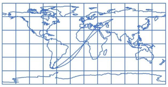
Figure 3.
World map in the normal aspect equidistant cylindrical projection. The almost straight line connecting the points with the coordinates , and , is the image of a loxodrome, and the curve that resembles the letter S, the image of an orthodrome that connects those same two points in the projection.
3.3. Loxodrome in the Equal-Area Cylindrical Projection of the Sphere
The equations of the normal aspect equal-area cylindrical projection of a sphere of radius R are
where is a constant [2,5,6]. If we substitute the expression for from (12) into (37), we can obtain the parametric equations of the image of the loxodrome
from which, assuming that , we can obtain the equation of the image of the loxodrome in the form
or
Since are constants, (39) or (40) do not represent a linear relationship between x and y, so the graphic representation of the loxodrome image in the plane of the equal-area cylindrical projection will not be a straight line but some other curve.
Figure 4 shows the world map in a normal aspect equal-area cylindrical projection. The almost straight line connecting the points with the coordinates , and , is the image of a loxodrome, and the curve that resembles the letter S, is the image of an orthodrome that connects those same two points in the projection.
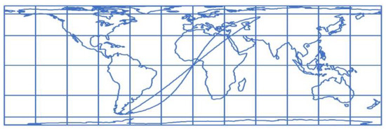
Figure 4.
World map in the normal aspect equal-area cylindrical projection. The almost straight line connecting the points with the coordinates , and , is the image of a loxodrome, and the curve that resembles the letter S is the image of the orthodrome connecting those same two points in the projection.
This means that the distance between two points on the image of the loxodrome in that projection cannot be obtained by the simple Formula (21). The differential of the arc of the image of the loxodrome in the plane of the equal-area cylindrical projection will be, assuming that
Integration gives
It can be shown that the solution of this integral cannot be written using elementary functions. The value of this integral can be calculated using a numerical integration method. It remains to be shown that the formula for the length of an arc of a loxodrome on a sphere can be derived from the relationship between the differential of the arc of the loxodrome image (41) and the factor of the local linear scale.
For the normal aspect equal-area cylindrical projection (37) the following holds [2,5,6]:
so for this projection, assuming that according to (5), it holds
and then for points on the loxodrome, considering (8)
Now we can write
After integrating expression (46), we obtain (25), which is a formula for calculating the length of a loxodrome arc on a sphere that is independent of the applied map projection and thus free from the distortions that the projection entails.
4. Final Considerations
Let the normal aspect cylindrical projection (4) be given. For such a projection,
where denotes the derivative of the function with respect to . Since , it is
Relation (48) is valid for the differential of any curve on the sphere that is represented in a normal aspect cylindrical projection (4). If it is a loxodrome, then (5) due to (8) can be written in the form
so when we substitute this into (48), assuming , we get
Conversely, for the normal aspect cylindrical projection (4), (5) holds. Since , and , we can write
Relation (51) is valid for the differential of any curve that is mapped from a sphere to the projection plane. If it is a loxodrome, then due to (8) we can write
and depending on the projection, i.e., on the local scales along the meridian h and the parallel k, integrating (52) gives the length of the arc of the loxodrome in the projection. Therefore, the formula which we usually use to determine the factor of the local linear scale, can also be used to calculate the length of the arc of a curve in the projection or to calculate the length of the arc of a curve on a sphere . The above is valid for any map projection.
5. Conclusions
Orthodromic navigation, although very promising, is possible only in automatic steering systems where an autopilot (course controller which stabilises the required course) is connected with a track controller, but such systems are very rare in marine navigation. Most common is a separate autopilot and for example a GPS receiver which sometimes can calculate the orthodromic or loxodromic course (mainly on a sphere) and this course must be manually set on an autopilot [7].
Every map projection carries certain distortions with it. To read the message written on a map, we need to know its distortions. For example, we often need the distance between two places. If we measure this distance from the map without taking the distortion into account, we will not get the correct value. We will get the correct value if we eliminate the distortion, that is, if we use expressions that do not contain distortion.
This article presents the problem of determining the distance measured along a loxodrome connecting two points on a sphere, assuming that we have an image of the loxodrome in a normal aspect cylindrical projection. Using the examples of the Mercator, equidistant and equal-area cylindrical projections, a formula has been derived that does not depend on the map projection used. This formula is not new, it is a new derivation using the theory of map projections. This has achieved two goals. The first, more or less known, is that when calculating the distance between two places shown on a map, the distortion inherent in the map due to the applied map projection should be taken into account. The second goal is to show how, using the theory of map projections, a formula can be derived that does not depend on the applied map projection.
Funding
This research received no external funding.
Data Availability Statement
No new data were created or analyzed in this study. Data sharing is not applicable to this article.
Conflicts of Interest
The author declares no conflicts of interest.
References
- Lapaine, M. Map Projection Article on Wikipedia. Advances in Cartography and GIScience of the International Cartographic Association. In Proceedings of the 29th International Cartographic Conference (ICC 2019), Tokyo, Japan, 15–20 July 2019; Volume 1, pp. 1–8. [Google Scholar] [CrossRef]
- Snyder, J.P. Map Projections: A Working Manual; USGS Professional Paper 1395; USGS: Washington, DC, USA, 1987. [Google Scholar]
- Euler, L. De repraesentatione superficiei sphaericae super plano. Acta Acad. Sci. Imp. Petropolitanae 1778, 1777, 107–132. [Google Scholar]
- Biernacki, F. Teoria Odwzorowań Powierzchni dla Geodetów i Kartografów; no. 4. Główny Urząd Pomiarów Kraju, Prace Geodezyjnego Instytutu Naukowo-Badawczego: Warsaw, Poland; 1949. (In Polish); Translated into English as Theory of Representation of Surfaces for Surveyors and Cartographers; U.S. Department of Commerce: Washington, DC, USA, 1965. [Google Scholar]
- Bugayevskiy, L.M.; Snyder, J.P. Map Projections—A Reference Manual; Taylor & Francis: London, UK, 1995. [Google Scholar]
- Frančula, N. Kartografske projekcije; textbook; Geodetski fakultet Sveučilišta u Zagrebu: Zagreb, Croatia, 2004. (In Croatian) [Google Scholar]
- Lenart, A.S. Orthodromes and Loxodromes in Marine Navigation. J. Navig. 2017, 70, 432–439. [Google Scholar] [CrossRef]


Disclaimer/Publisher’s Note: The statements, opinions and data contained in all publications are solely those of the individual author(s) and contributor(s) and not of MDPI and/or the editor(s). MDPI and/or the editor(s) disclaim responsibility for any injury to people or property resulting from any ideas, methods, instructions or products referred to in the content. |
© 2025 by the author. Published by MDPI on behalf of the International Society for Photogrammetry and Remote Sensing. Licensee MDPI, Basel, Switzerland. This article is an open access article distributed under the terms and conditions of the Creative Commons Attribution (CC BY) license (https://creativecommons.org/licenses/by/4.0/).