
Anthropogenic Impact on Beach Heterogeneity within a Littoral Cell (Northern Tuscany, Italy)

 ,
,  , ,
, , 
Abstract
1. Introduction
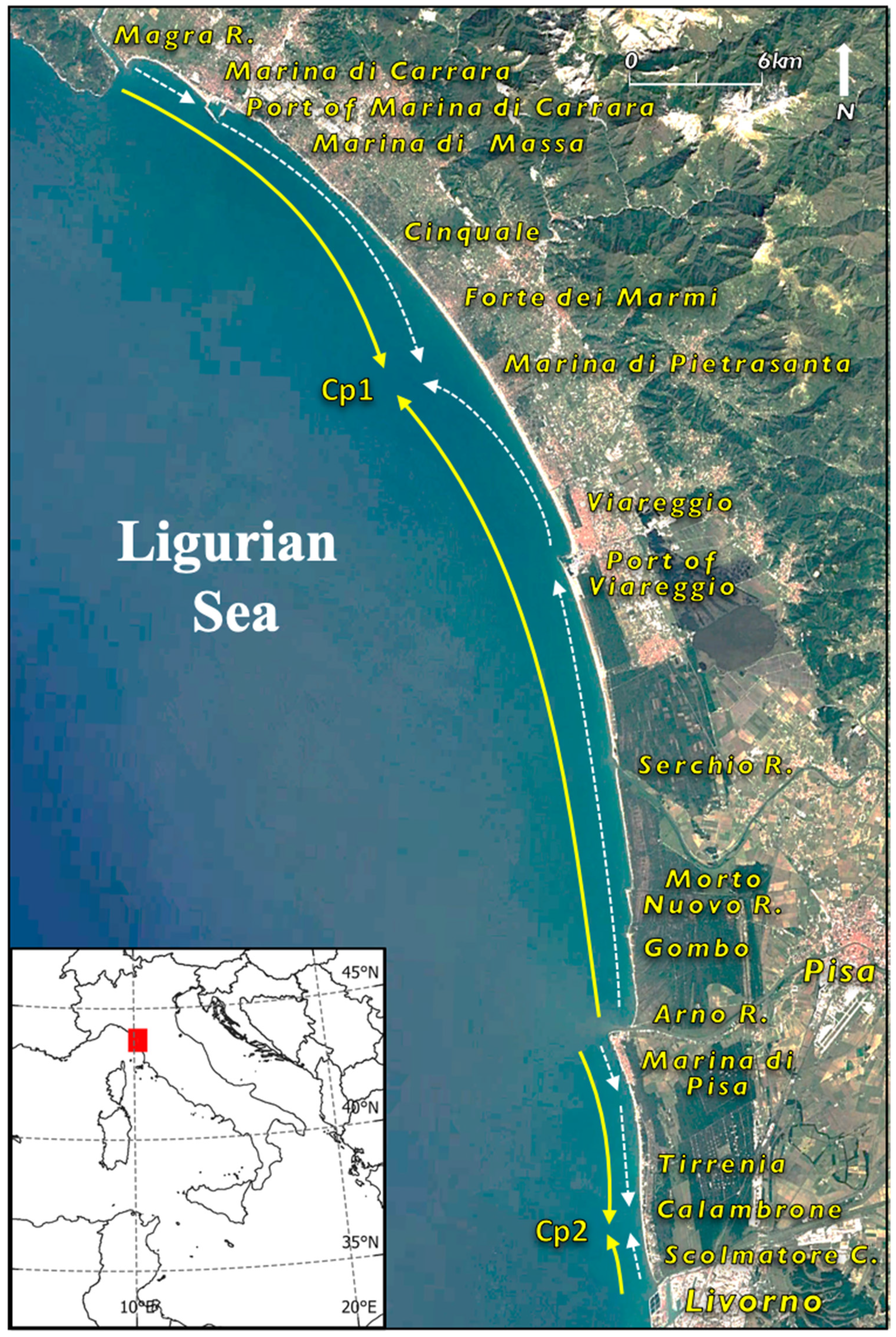
2. The Study Area
3. Materials and Methods
4. Results
4.1. Ports
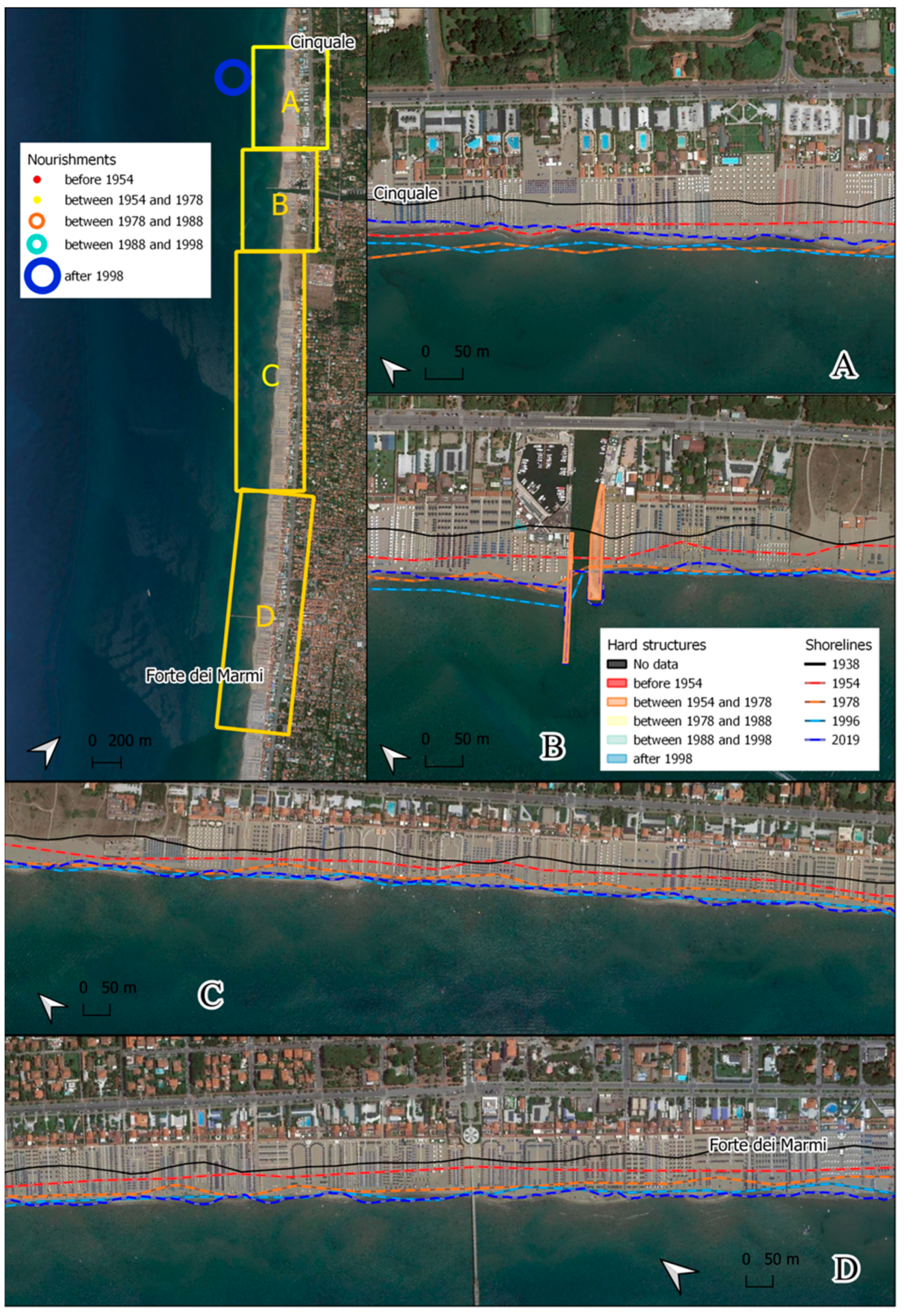
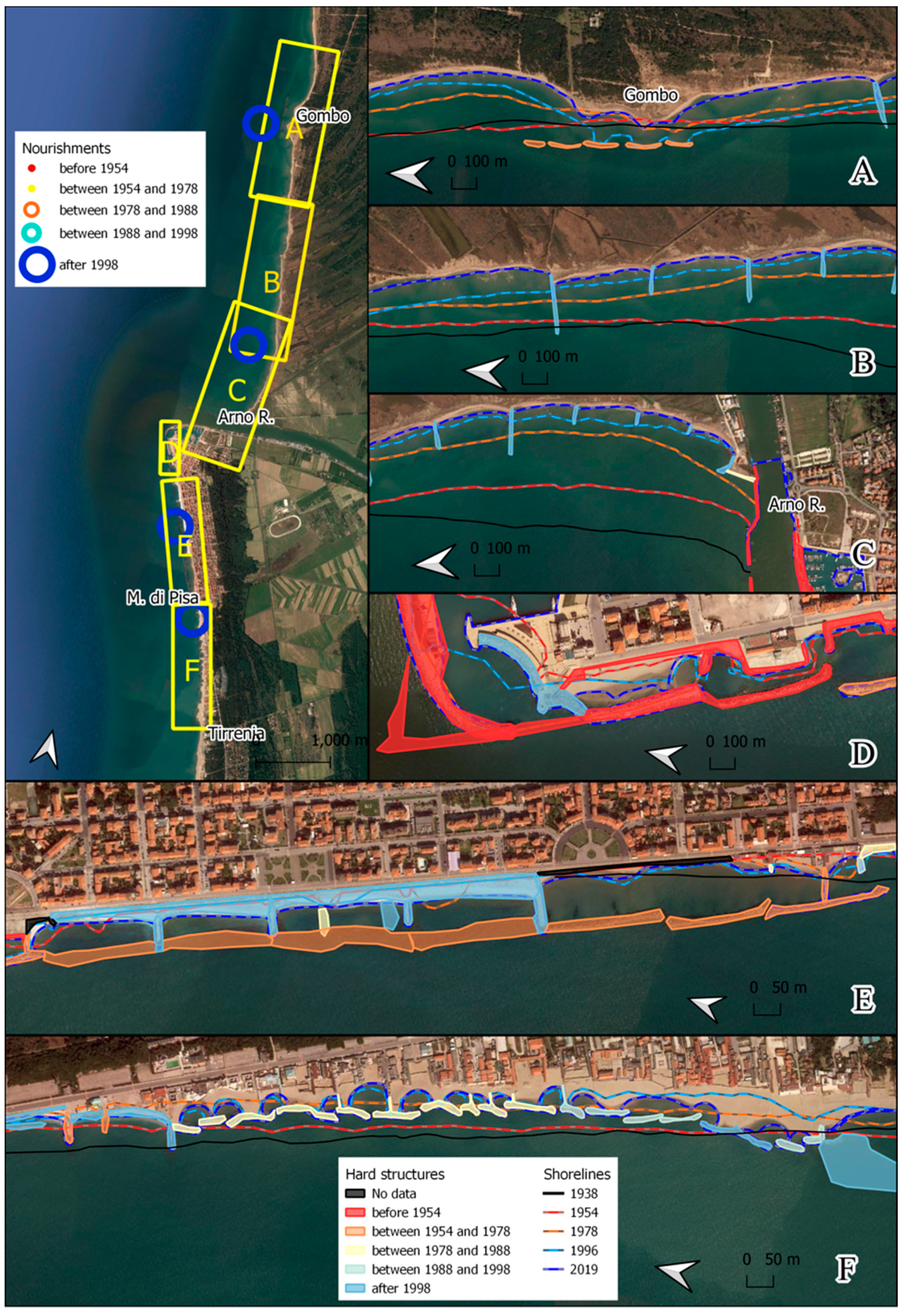
4.2. Hard Protection Structures
4.3. Soft Protection Structures
5. Discussion
6. Conclusions
Author Contributions
Funding
Institutional Review Board Statement
Informed Consent Statement
Data Availability Statement
Acknowledgments
Conflicts of Interest
References
- Segalstad, T.V. Carbon cycle modelling and the residence time of natural and anthropogenic atmospheric CO2: On the construction of the “Greenhouse Effect Global Warming” dogma. In Global Warming: The Continuing Debate; Bate, R., Ed.; European Science and Environment Forum (ESEF): Cambridge, UK, 1998; pp. 184–219. [Google Scholar]
- Rosenzweig, C.; Karoly, D.; Vicarelli, M.; Neofotis, P.; Wu, Q.; Casassa, G.; Menzel, A.; Root, T.L.; Estrella, N.; Seguin, B.; et al. Attributing physical and biological impacts to anthropogenic climate change. Nature 2008, 453, 353–357. [Google Scholar] [CrossRef]
- Liu, J.; Wang, B.; Cane, M.A.; Yim, S.Y.; Lee, J.Y. Divergent global precipitation changes induced by natural versus anthropogenic forcing. Nature 2013, 493, 656–659. [Google Scholar] [CrossRef]
- Xie, S.P.; Kosaka, Y.; Okumura, Y.M. Distinct energy budgets for anthropogenic and natural changes during global warming hiatus. Nat. Geosci. 2016, 9, 29–33. [Google Scholar] [CrossRef]
- Al-Ghussain, L. Global warming: Review on driving forces and mitigation. Environ. Prog. Sustain. 2019, 38, 13–21. [Google Scholar] [CrossRef]
- Sweet, W.V.; Park, J. From the extreme to the mean: Acceleration and tipping points of coastal inundation from sea level rise. Earth’s Future 2014, 2, 579–600. [Google Scholar] [CrossRef]
- Jackson, L.P.; Jevrejeva, S. A probabilistic approach to 21st century regional sea-level projections using RCP and High-end scenarios. Glob. Planet. Chang. 2016, 146, 179–189. [Google Scholar] [CrossRef]
- Mengel, M.; Nauels, A.; Rogelj, J.; Schleussner, C.F. Committed sea-level rise under the Paris Agreement and the legacy of delayed mitigation action. Nat. Commun. 2018, 9, 601. [Google Scholar] [CrossRef]
- Vousdoukas, M.I.; Mentaschi, L.; Voukouvalas, E.; Verlaan, M.; Jevrejeva, S.; Jackson, L.P.; Feyen, L. Global probabilistic projections of extreme sea levels show intensification of coastal flood hazard. Nat. Commun. 2018, 9, 2360. [Google Scholar] [CrossRef]
- Taherkhani, M.; Vitousek, S.; Barnard, P.L.; Frazer, N.; Anderson, T.R.; Fletcher, C.H. Sea-Level rise exponentially increases coastal flood frequency. Sci. Rep. 2020, 10, 6466. [Google Scholar] [CrossRef]
- Stocker, T.F.; Qin, D.; Plattner, G.K.; Tignor, M.M.B.; Allen, S.K.; Boschung, J.; Nauels, A.; Xia, Y.; Bex, V.; Midgley, P.M. Climate Change 2013: The Physical Science Basis. Contribution of Working Group I to the Fifth Assessment Report of the Intergovernmental Panel on Climate Change; Cambridge University Press: Cambridge, UK, 2014; p. 1535. [Google Scholar] [CrossRef]
- Field, C.B. Climate Change 2014: Impacts, Adaptations, and Vulnerability: Regional Aspects. Contribution of Working Group II to the Fifth Assessment Report of the Intergovernmental Panel on Climate Change; Cambridge University Press: Cambridge, UK, 2014; p. 688. [Google Scholar]
- Oppenheimer, M.; Glavovic, B.C.; Hinkel, J.; van de Wal, R.; Magnan, A.K.; Abd-Elgawad, A.; Cai, R.; Cifuentes-Jara, M.; DeConto, R.M.; Ghosh, T.; et al. Sea Level Rise and Implications for Low-Lying Islands, Coasts and Communities. In IPCC Special Report on the Ocean and Cryosphere in a Changing Climate; Pörtner, H.-O., Roberts, D.C., Masson-Delmotte, V., Zhai, P., Tignor, M., Poloczanska, E., Mintenbeck, K., Alegría, A., Nicolai, M., Okem, A., et al., Eds.; IPCC: Geneva, Switzerland, 2019; pp. 321–445. [Google Scholar]
- Neumann, B.; Vafeidis, A.T.; Zimmermann, J.; Nicholls, R.J. Future coastal population growth and exposure to sea-level rise and coastal flooding—A global assessment. PLoS ONE 2015, 10, e0118571. [Google Scholar] [CrossRef]
- Refaat, M.M.; Eldeberky, Y. Assessment of coastal inundation due to sea-level rise along the Mediterranean Coast of Egypt. Mar. Geod. 2016, 39, 290–304. [Google Scholar] [CrossRef]
- Antonioli, F.; Anzidei, M.; Amorosi, A.; Lo Presti, V.; Mastronuzzi, G.; Deiana, G.; De Falco, G.; Fontana, A.; Fontolan, G.; Lisco, S.; et al. Sea-Level rise and potential drowning of the Italian coastal plains: Flooding risk scenarios for 2100. Quat. Sci. Rev. 2017, 158, 29–43. [Google Scholar] [CrossRef]
- Catalao, J.; Raju, D.; Nico, G. InSAR maps of land subsidence and sea level scenarios to quantify the flood inundation risk in coastal cities: The case of Singapore. Remote Sens. 2020, 12, 296. [Google Scholar] [CrossRef]
- Pranzini, E. Updrift river mouth migration on cuspate deltas: Two examples from the coast of Tuscany (Italy). Geomorphology 2001, 38, 125–132. [Google Scholar] [CrossRef]
- Pratellesi, M.; Ciavola, P.; Ivaldi, R.; Anthony, E.J.; Armaroli, C. River-Mouth geomorphological changes over >130 years (1882–2014) in a small Mediterranean delta: Is the Magra delta reverting to an estuary? Mar. Geol. 2018, 403, 215–224. [Google Scholar] [CrossRef]
- Cappucci, S.; Bertoni, D.; Cipriani, L.E.; Boninsegni, G.; Sarti, G. Assessment of the anthropogenic sediment budget of a littoral cell system (Northern Tuscany, Italy). Water 2020, 12, 3240. [Google Scholar] [CrossRef]
- Bertoni, D.; Alquini, F.; Bini, M.; Ciccarelli, D.; Giaccari, R.; Pozzebon, A.; Ribolini, A.; Sarti, G. A technical solution to assess multiple data collection on beach dunes: The pilot site of migliarino San Rossore regional park (Tuscany, Italy). Atti. Soc. Toscana Sci. Nat. Mem. Ser. A 2014, 121, 5–12. [Google Scholar] [CrossRef]
- Bonaldo, D.; Antonioli, F.; Archetti, R.; Bezzi, A.; Correggiari, A.; Davolio, S.; De Falco, G.; Fantini, M.; Fontolan, G.; Furlani, S.; et al. Integrating multidisciplinary instruments for assessing coastal vulnerability to erosion and sea level rise: Lessons and challenges from the Adriatic Sea, Italy. J. Coast. Conserv. 2019, 23, 19–37. [Google Scholar] [CrossRef]
- Myers, M.R.; Barnard, P.L.; Beighley, E.; Cayan, D.R.; Dugan, J.E.; Feng, D.; Hubbard, D.M.; Iacobellis, S.F.; Melack, J.M.; Page, H.M. A multidisciplinary coastal vulnerability assessment for local government focused on ecosystems, Santa Barbara area, California. Ocean Coast. Manag. 2019, 182, 104921. [Google Scholar] [CrossRef]
- Harley, M.D.; Turner, I.L.; Short, A.D.; Ranasinghe, R. Assessment and integration of conventional, RTK-GPS and image-derived beach survey methods for daily to decadal coastal monitoring. Coast. Eng. 2011, 58, 194–205. [Google Scholar] [CrossRef]
- Bartolini, S.; Mecocci, A.; Pozzebon, A.; Zoppetti, C.; Bertoni, D.; Sarti, G.; Caiti, A.; Costanzi, R.; Catani, F.; Ciampalini, A.; et al. Augmented virtuality for coastal management: A holistic use of in situ and remote sensing for large scale definition of coastal dynamics. ISPRS Int. J. Geo Inf. 2018, 7, 92. [Google Scholar] [CrossRef]
- Turner, I.L.; Harley, M.D.; Drummond, C.D. UAVs for coastal surveying. Coast. Eng. 2016, 114, 19–24. [Google Scholar] [CrossRef]
- Casella, E.; Rovere, A.; Pedroncini, A.; Mucerino, L.; Casella, M.; Cusati, L.A.; Vacchi, M.; Ferrari, M.; Firpo, M. Study of wave runup using numerical models and low-altitude aerial photogrammetry: A tool for coastal management. Estuar. Coast. Shelf Sci. 2014, 149, 160–167. [Google Scholar] [CrossRef]
- Pikelj, K.; Ruzic, I.; Ilic, S.; James, M.R.; Kordic, B. Implementing an efficient beach erosion monitoring system for coastal management in Croatia. Ocean Coast. Manag. 2018, 156, 223–238. [Google Scholar] [CrossRef]
- Andriolo, U.; Elena, S. Operational Use of Surfcam Online Streaming Images for Coastal Morphodynamic Studies. Remote Sens. 2019, 11, 78. [Google Scholar] [CrossRef]
- Ibaceta, R.; Splinter, K.D.; Harley, M.D.; Turner, I.L. Enhanced Coastal Shoreline Modeling Using an Ensemble Kalman Filter to Include Nonstationarity in Future Wave Climates. Geophys. Res. Lett. 2020, 47, e2020GL090724. [Google Scholar] [CrossRef]
- Ranasinghe, R. On the need for a new generation of coastal change models for the 21st century. Sci. Rep. 2020, 10, 2010. [Google Scholar] [CrossRef]
- Bruno, M.F.; Saponieri, A.; Molfetta, M.G.; Damiani, L. The DPSIR Approach for Coastal Risk Assessment under Climate Change at Regional Scale: The Case of Apulian Coast (Italy). J. Mar. Sci. Eng. 2020, 8, 531. [Google Scholar] [CrossRef]
- Apollonio, C.; Bruno, M.F.; Iemmolo, G.; Molfetta, M.G.; Pellicani, R. Flood Risk Evaluation in Ungauged Coastal Areas: The Case Study of Ippocampo (Southern Italy). Water 2020, 12, 1466. [Google Scholar] [CrossRef]
- Cigliano, J.A.; Meyer, R.; Ballard, H.L.; Freitag, A.; Phillips, T.B.; Wasser, A. Making marine and coastal citizen science matter. Ocean Coast. Manag. 2015, 115, 77–87. [Google Scholar] [CrossRef]
- Harley, M.D.; Kinsela, M.A.; Sánchez-García, E.; Vos, K. Shoreline change mapping using crowd-sourced smartphone images. Coast. Eng. 2019, 150, 175–189. [Google Scholar] [CrossRef]
- Cipriani, L.E.; Ferri, S.; Iannotta, P.; Paolieri, F.; Pranzini, E. Morfologia e dinamica dei sedimenti del litorale della Toscana settentrionale. Stud. Cost. 2001, 4, 119–156. [Google Scholar]
- Sarti, G.; Bertoni, D. Monitoring backshore and foreshore gravel deposits on a mixed sand and gravel beach (Apuane-Versilia coast, Tuscany, Italy). GeoActa 2007, 6, 73–81. [Google Scholar]
- Garzanti, E.; Canclini, S.; Moretti Foggia, F.; Petrella, N. Unraveling magmatic and orogenic provenance in modern sand: The back-arc side of the Apennine thrust belt, Italy. J. Sediment. Res. 2002, 72, 2–17. [Google Scholar] [CrossRef]
- Del Furia, L.; De Filippi, G.; D’Oriano, V.; Luciani, L.; Caminelli, M. Evoluzione morfologica della costa toscana: Principali risultati dello studio e ricerca per l’implementazione del quadro conoscitivo della costa toscana nell’ambito del Piano Regionale di Gestione Integrata della Costa. In Il Piano Regionale di Gestione Integrata della Costa ai Fini del Riassetto Idrogeologico—L’implementazione del Quadro Conoscitivo; Cipriani, L.E., Regoli, C., Eds.; Regione Toscana: Florence, Italy, 2008; pp. 11–34. [Google Scholar]
- Aiello, E.; Bartolini, C.; Caputo, C.; D’Alessandro, L.; Fanucci, F.; Fierro, G.; Gnaccolini, M.; La Monica, G.B.; Lupia Palmieri, E.; Piccazzo, M.; et al. Il trasporto litoraneo lungo la costa toscana tra la foce del fiume Magra ed i Monti dell’Uccellina. Boll. Soc. Geol. Ital. 1975, 94, 1519–1571. [Google Scholar]
- Pranzini, E.; Cinelli, I.; Cipriani, L.E.; Anfuso, G. An integrated coastal sediment management plan: The example of the Tuscany region (Italy). J. Mar. Sci. Eng. 2020, 8, 33. [Google Scholar] [CrossRef]
- Cappucci, S.; Scarcella, D.; Rossi, L.; Taramelli, A. Integrated Coastal Zone Management at Marina di Carrara Harbor: Sediment management and policy making. J. Ocean Coast. Manag. 2011, 54, 277–289. [Google Scholar] [CrossRef]
- Bertoni, D.; Giacomelli, S.; Ciulli, L.; Sarti, G. Litho-Sedimentological and morphodynamic characterization of the Pisa Province coastal area (northern Tuscany, Italy). J. Maps 2020, 16, 108–116. [Google Scholar] [CrossRef]
- Aminti, P.; Iannotta, P.; Pranzini, E. Morfodinamica di un sistema costiero intensamente protetto: Il litorale di Marina di Massa. Atti Conv. Lincei 1999, 154, 263–270. [Google Scholar]
- Cammelli, C.; Jackson, N.L.; Nordstrom, K.F.; Pranzini, E. Assessment of a gravel nourishment project frontin a seawall at Marina di Pisa, Italy. J. Coast. Res. 2006, 2, 770–775. [Google Scholar]
- Nordstrom, K.F.; Pranzini, E.; Jackson, N.L.; Coli, M. The marble beaches of Tuscany. Geogr. Rev. 2008, 98, 280–300. [Google Scholar] [CrossRef]
- Bertoni, D.; Sarti, G.; Benelli, G.; Pozzebon, A. In situ abrasion of marked pebbles on two coarse-clastic beaches (Marina di Pisa, Italy). Ital. J. Geosci. 2012, 131, 205–214. [Google Scholar] [CrossRef]
- Pranzini, E.; Anfuso, G.; Cinelli, I.; Piccardi, M.; Vitale, G. Shore Protection Structures Increase and Evolution on the Northern Tuscany Coast (Italy): Influence of Tourism Industry. Water 2018, 10, 1647. [Google Scholar] [CrossRef]
- Crowell, M.; Leatherman, S.P.; Buckley, M.K. Historical shoreline change: Error analysis and mapping accuracy. J. Coast. Res. 1991, 7, 839–852. [Google Scholar]
- Cipriani, L.E.; Pranzini, E.; Vitale, G. Coastal erosion in Tuscany: Short vs. medium term evolution. In Coastal Erosion Monitoring. A Network of Regional Observatories—Results from RESMAR Project; Cipriani, L.E., Ed.; Nuova Grafica Fiorentina: Florence, Italy, 2013; pp. 135–155. [Google Scholar]
- Da Pozzo, C. Il Porto di Marina di Carrara: Geografia di un Porto Minore; Felici Editore: Pisa, Italy, 1982. [Google Scholar]
- Bernieri, A.; Mannoni, L.; Mannoni, T. Il Porto di Carrara. Storia e Attualità; SAGEP Editrice: Genoa, Italy, 1983; p. 240. [Google Scholar]
- Pellegrinetti, G.A. La costruzione del porto di Viareggio e le conseguenti erosioni. In Proceedings of the Atti del IX Congresso Geografico Italiano, Genoa, Italy, 22–30 April 1924; pp. 70–78. [Google Scholar]
- Anfuso, G.; Pranzini, E.; Vitale, G. An integrated approach to coastal erosion problems in northern Tuscany (Italy): Littoral morphological evolution and cell distribution. Geomorphology 2011, 129, 204–214. [Google Scholar] [CrossRef]
- Milano, V. Studio sull’accessibilità del porto di Viareggio e sull’equilibrio della spiaggia a Nord. In Proceedings of the Atti del XX Convegno di Idraulica e Costruzioni Idrauliche, Padua, Italy, 8–10 September 1986; pp. 255–264. [Google Scholar]
- Albani, D. Le spiagge della Toscana settentrionale dalla foce del fiume Magra ai Monti Livornesi. In Ricerche Sulle Variazioni delle Spiagge Italiane. II—Le Spiagge Toscane; CNR: Rome, Italy, 1940; pp. 11–86. [Google Scholar]
- Piccardi, M.; Pranzini, E.; Rombai, L. Historical cartography and coastal dynamics of the Apuan littoral in the modern and contemporary periods: The port of Marina di Carrara (Tuscany, Italy). e-Perimetron 2018, 13, 32–49. [Google Scholar]
- Ferri, S.; Pelliccia, F.; Pranzini, E.; Rizzo, M.; Vitale, G. Prima risposta della spiaggia di Marina di Carrara ad un ripascimento artificiale non protetto. Stud. Cost. 2008, 15, 57–72. [Google Scholar]
- Pranzini, E. Shore protection in Italy: From hard to soft engineering… and back. Ocean Coast. Manag. 2018, 156, 43–57. [Google Scholar] [CrossRef]
- Aminti, P.; Pelliccia, F.; Pranzini, E. Evoluzione del profilo di spiaggia a seguito di un ripascimento artificiale in ghiaia su di una spiaggia altamente protetta. Stud. Cost. 2002, 5, 47–57. [Google Scholar]
- Mancinelli, A.; Aminti, P.; Archetti, R.; Atzeni, A.; Canu, V.; Cappietti, L.; Lorenzoni, C.; Zanuttigh, B. Opere di difesa realizzate con strutture sommerse ed a cresta bassa ad Alghero (SS), Perd’e Sali (CA), Marina di Massa (MS), Marina di Pisa (PI), Porto Recanati (MC), Marina di Montemarciano (AN), Lido di Dante (RA) e Pallestrina (VE). Stud. Cost. 2005, 9, 7–50. [Google Scholar]
- Aminti, P.; Graniglia, N.; Stefani, G. Il recupero della spiaggia di Marina di Massa. In La Rete per il Monitoraggio delle Spiagge—Applicazioni ed Esperienze Sviluppate nel Progetto ResMar (Azione di Sistema A); Editrice Taphros: Olbia, Italy, 2013; pp. 152–178. [Google Scholar]
- Aminti, P.; Cammelli, C.; Cappietti, L.; Jackson, N.L.; Nordstrom, K.F.; Pranzini, E. Evaluation of beach response to submerged groin construction at Marina di Ronchi, Italy, using field data and a numerical simulation model. J. Coast. Res. 2004, SI33, 99–120. [Google Scholar]
- Bini, M.; Casarosa, N.; Ribolini, A. Multitemporal (1938–2004) evolution of the Pisan shoreline based on the comparison of georeferenced aerial images. Atti Soc. Toscana Sci. Nat. Mem. Ser. A 2008, 113, 1–12. [Google Scholar]
- Rapetti, F.; Vittorini, S. Osservazioni sulle variazioni dell’ala destra del delta dell’Arno. Atti Soc. Toscana Sci. Nat. Mem. Ser. A 1974, 81, 25–88. [Google Scholar]
- Bowman, D.; Pranzini, E. Reversed responses within a segmented detached breakwater, the Tuscany coast Italy—A case study. Coast. Eng. 2003, 49, 263–274. [Google Scholar] [CrossRef]
- Pranzini, E. L’intervento di stabilizzazione del litorale de Le Lame (Parco San Rossore Migliarino Massaciuccoli, Toscana). Stud. Cost. 2008, 14, 29–42. [Google Scholar]
- Aminti, P.; Cipriani, L.E.; Pranzini, E. Back to the beach: Converting seawalls into gravel beaches. In Proceedings of the First International Soft Shore Protection Conference, Patras, Greece, 18–22 October 2000; pp. 187–196. [Google Scholar]
- Casarosa, N. Studio dell’evoluzione del litorale pisano tramite rilievi con GPS differenziale (2008–2014). Monitoraggio dell’evoluzione della linea di riva del litorale pisano. Stud. Cost. 2016, 23, 3–20. [Google Scholar]
- Aminti, P.L.; Cipriani, L.E.; Pranzini, E. An Innovative, Non-Structural Solution to Beach Erosion: Costs Less and Delivers More Benefits. InterCoast Net. 1999, 33, 34–35. [Google Scholar]
- Cipriani, L.E.; Pranzini, E. Minimizing Conflicts among Stakeholders within a Littoral Cell. In Proceedings of the Ninth International Conference on the Mediterranean Coastal Environment, MEDCOAST 09, Sochi, Russia, 10–14 November 2009; pp. 535–546. [Google Scholar]
- Cipriani, L.E.; Pelliccia, F.; Pranzini, E. Beach nourishment with nearshore sediments in a highly protected beach. In Proceedings of the MEDCOAST 99—EMECS 99 Joint Conference: Land Ocean Interactions—Managing Coastal Ecosystems, Antalya, Turkey, 9–13 November 1999; pp. 1579–1590. [Google Scholar]
- Stive, M.J.F.; de Schipper, M.A.; Luijendijk, A.P.; Aarninkhof, S.G.J.; van Gelder-Maas, C.; van Thiel de Vries, J.S.M.; de Vries, S.; Henriquez, M.; Marx, S.; Ranasinghe, R. A new alternative to saving our beaches from sea-level rise: The Sand Engine. J. Coast. Res. 2013, 29, 1001–1008. [Google Scholar] [CrossRef]
- Spodar, A.; Héquette, A.; Ruz, M.H.; Cartier, A.; Gregoire, P.; Sipka, V.; Forain, N. Evolution of a beach nourishment project using dredged sand from navigation channel, Dunkirk, northern France. J. Coast. Conserv. 2018, 22, 457–474. [Google Scholar] [CrossRef]
- Berriolo, G.; Sirito, G. Spiagge e Porti Turistici; U. Hoepli Editore: Milan, Italy, 1972; p. 428. [Google Scholar]
- Alquini, F.; Bertoni, D.; Sarti, G. Extreme erosion of a dune crest within a short timespan (January–September 2016): The recent case in the Migliarino—San Rossore—Massaciuccoli Regional Park (Tuscany, Italy). Atti Soc. Toscana Sci. Nat. Memorie Ser. A 2016, 123, 5–16. [Google Scholar] [CrossRef]
- Bertoni, D.; Sarti, G. On the profile evolution of three artificial pebble beaches at Marina di Pisa, Italy. Geomorphology 2011, 130, 244–254. [Google Scholar] [CrossRef]
- Bertoni, D.; Sarti, G.; Grottoli, E.; Ciavola, P.; Pozzebon, A.; Domokos, G.; Novák-Szabó, T. Impressive abrasion rates of marked pebbles on a coarse-clastic beach within a 13-month timespan. Mar. Geol. 2016, 381, 175–180. [Google Scholar] [CrossRef]
- Bertoni, D.; Dean, S.; Trembanis, A.C.; Sarti, G. Multi-Month sedimentological characterization of the backshore of an artificial coarse-clastic beach in Italy. Rend. Lincei 2020, 31, 65–77. [Google Scholar] [CrossRef]
- Pranzini, E. The erosion of the Ombrone river delta (Italy). Littoral 1994, 94, 133–147. [Google Scholar]
- Sarti, G.; Bini, M.; Giacomelli, S. The growth and decline of Pisa (Tuscany, Italy) up to the Middle Ages: Correlations with landscape and geology. Alpine Mediterr. Quatern. 2010, 23, 311–322. [Google Scholar]
- Di Pasquale, G.; Buonincontri, M.P.; Allevato, E.; Saracino, A. Human-Derived landscape changes on the northern Etruria coast (western Italy) between Roman times and the late Middle Ages. Holocene 2014, 24, 1491–1502. [Google Scholar] [CrossRef]
- Benjamin, J.; Rovere, A.; Fontana, A.; Furlani, S.; Vacchi, M.; Inglis, R.H.; Galili, E.; Antonioli, F.; Sivan, D.; Miko, S.; et al. Late Quaternary sea-level changes and early human societies in the central and eastern Mediterranean Basin: An interdisciplinary review. Quatern. Int. 2017, 449, 29–57. [Google Scholar] [CrossRef]
- Kaniewski, D.; Marriner, N.; Morhange, C.; Vacchi, M.; Sarti, G.; Rossi, V.; Bini, M.; Pasquinucci, M.; Allinne, C.; Otto, T.; et al. Holocene evolution of Portus Pisanus, the lost harbour of Pisa. Sci. Rep. 2018, 8, 1–14. [Google Scholar] [CrossRef]
- Amorosi, A.; Bini, M.; Giacomelli, S.; Pappalardo, M.; Ribecai, C.; Rossi, V.; Sammartino, I.; Sarti, G. Middle to late Holocene environmental evolution of the Pisa coastal plain (Tuscany, Italy) and early human settlements. Quatern. Int. 2013, 303, 93–106. [Google Scholar] [CrossRef]
- Doody, P.; Ferreira, M.; Lombardo, S.; Lucius, I.; Misdorp, R.; Niesing, H.; Salman, A.; Smallegange, M. Living with Coastal Erosion in Europe: Sediment and Space for Sustainability; Office for Official Publications of the European Communities: Luxembourg, 2004; p. 40. [Google Scholar]
- Poulos, S.; Chronis, G. Coastline changes in relation to longshore sediment transport and human impact, along the shoreline of Kato Achaia (NW Peloponnese, Greece). Mediterr. Mar. Sci. 2001, 2, 5–14. [Google Scholar] [CrossRef]
- Ghionis, G.; Poulos, S.E.; Karditsa, A. Deltaic coastline retreat due to dam construction: The case of the River Alfios mouth area (Kyparissiakos Gulf, Ionian Sea). J. Coast. Res. 2013, 65, 2119–2124. [Google Scholar] [CrossRef]
- Traini, C.; Proust, J.N.; Menier, D.; Mathew, M.J. Distinguishing natural evolution and human impact on estuarine morpho-sedimentary development: A case study from the Vilaine Estuary, France. Estuar. Coast. Shelf Sci. 2015, 163, 143–155. [Google Scholar] [CrossRef]
- Payo, A.; Walkden, M.; Ellis, M.A.; Barkwith, A.; Favis-Mortlock, D.; Kessler, H.; Wood, B.; Burke, H.; Lee, J. A Quantitative Assessment of the Annual Contribution of Platform Downwearing to Beach Sediment Budget: Happisburgh, England, UK. J. Mar. Sci. Eng. 2018, 6, 113. [Google Scholar] [CrossRef]
- Cabezas-Rabadan, C.; Pardo-Pascual, J.E.; Palomar-Vazquez, J.; Fernandez-Sarria, A. Characterizing beach changes using high-frequency Sentinel-2 derived shorelines on the Valencian coast (Spanish Mediterranean). Sci. Total Environ. 2019, 691, 216–231. [Google Scholar] [CrossRef]
- Evelpidou, Ν.; Vassilopoulos, A.; Leonidopoulou, D.; Poulos, S. An investigation of the coastal erosion causes in Samos island, eastern Aegean sea. J. Landsc. Ecol. 2009, 6, 295–310. [Google Scholar]
- Juracic, M.; Benac, C.; Pikelj, K.; Ilic, S. Comparison of the vulnerability of limestone (karst) and siliciclastic coasts (example from the Kvarner area, NE Adriatic, Croatia). Geomorphology 2009, 107, 90–99. [Google Scholar] [CrossRef]
- Earlie, C.S.; Masselink, G.; Russell, P.E.; Shail, R.K. Application of airborne LiDAR to investigate rates of recession in rocky coast environments. J. Coast. Conserv. 2015, 19, 831–845. [Google Scholar] [CrossRef]
- Molina, R.; Anfuso, G.; Manno, G.; Gracia Prieto, F.J. The Mediterranean Coast of Andalusia (Spain): Medium-Term Evolution and Impacts of Coastal Structures. Sustainability 2019, 11, 3539. [Google Scholar] [CrossRef]
- Nave, S.; Rebelo, L. Coastline evolution of the Portuguese south eastern coast: A high-resolution approach in a 65 years’ time-window. J. Coast. Conserv. 2021, 25, 7. [Google Scholar] [CrossRef]
- Kerguillec, R.; Audère, M.; Baltzer, A.; Debaine, F.; Fattal, P.; Juigner, M.; Launeau, P.; Le Mauff, B.; Luquet, F.; Maanan, M.; et al. Monitoring and management of coastal hazards: Creation of a regional observatory of coastal erosion and storm surges in the pays de la Loire region (Atlantic coast, France). Ocean Coast. Manag. 2019, 181, 104904. [Google Scholar] [CrossRef]
- Ferrari, M.; Cabella, R.; Berriolo, G.; Montefalcone, M. Gravel Sediment Bypass between Contiguous Littoral Cells in the NW Mediterranean Sea. J. Coast. Res. 2014, 30, 183–191. [Google Scholar] [CrossRef]
- Sarid, N.; Goodman-Chernov, B.; Lazar, M. Anthropogenic Impacts on the End of a Sand Nourishing Littoral Cell—A Case Study from the Eastern Mediterranean. Geophysical Research Abstracts. In Proceedings of the EGU General Assembly, Wien, Austria, 7–12 April 2019. [Google Scholar]
- Kalpakis, V.; Kokkos, N.; Pisinaras, V.; Sylaios, G. An integrated coastal zone observatory at municipal level: The case of Kavala Municipality, NE Greece. J. Coast. Conserv. 2019, 23, 149–162. [Google Scholar] [CrossRef]
- Anfuso, G.; Martínez-del Pozo, J.Á.; Rangel-Buitrago, N. Morphological cells in the Ragusa littoral (Sicily, Italy). J. Coast. Conserv. 2013, 17, 369–377. [Google Scholar] [CrossRef]
- Carter, R.W.G. Coastal Environments; Academic Press: London, UK, 1988; p. 617. [Google Scholar]
- Bray, M.; Carter, D.; Hooke, J. Littoral cell definition and budgets for central southern England. J. Coast. Res. 1995, 11, 381–400. [Google Scholar]
- Gandolfi, G.; Paganelli, L. Il litorale pisano-versiliese (Area campione Alto Tirreno). Composizione, provenienza e dispersione delle sabbie. Boll. Soc. Geol. Ital. 1975, 94, 1273–1295. [Google Scholar]
- Ciampalini, A.; Consoloni, I.; Salvatici, T.; Di Traglia, F.; Fidolini, F.; Sarti, G.; Moretti, S. Characterization of coastal environment by means of hyper- and multispectral techniques. Appl. Geogr. 2015, 57, 120–132. [Google Scholar] [CrossRef]


| Time Intervals | Color in the Maps |
|---|---|
| Pre–1954 | Red |
| 1954–1978 | Orange |
| 1978–1988 | Yellow |
| 1988–1998 | Cyan |
| Post–1998 | Blue |
| Year | Ownership Organization | Data Type | Properties | Error 1 | Color in the Maps |
|---|---|---|---|---|---|
| 1938 | IGM 2 | Cartography | Scale 1:100,000 | 1.5–11 m | Black |
| 1954 | Region of Tuscany | Aerial imagery | Black-and-white film | <2.5 m | Red |
| 1978 | Region of Tuscany | Aerial imagery | Black-and-white film | <1.5 m | Orange |
| 1996 | Region of Tuscany | Aerial imagery | Black-and-white film | <1.5 m | Cyan |
| 2019 | Region of Tuscany | Satellite imagery | RGB | ~1 m | Blue |
Publisher’s Note: MDPI stays neutral with regard to jurisdictional claims in published maps and institutional affiliations. |
© 2021 by the authors. Licensee MDPI, Basel, Switzerland. This article is an open access article distributed under the terms and conditions of the Creative Commons Attribution (CC BY) license (http://creativecommons.org/licenses/by/4.0/).
Share and Cite
Bertoni, D.; Bini, M.; Luppichini, M.; Cipriani, L.E.; Carli, A.; Sarti, G. Anthropogenic Impact on Beach Heterogeneity within a Littoral Cell (Northern Tuscany, Italy). J. Mar. Sci. Eng. 2021, 9, 151. https://doi.org/10.3390/jmse9020151
Bertoni D, Bini M, Luppichini M, Cipriani LE, Carli A, Sarti G. Anthropogenic Impact on Beach Heterogeneity within a Littoral Cell (Northern Tuscany, Italy). Journal of Marine Science and Engineering. 2021; 9(2):151. https://doi.org/10.3390/jmse9020151
Chicago/Turabian StyleBertoni, Duccio, Monica Bini, Marco Luppichini, Luigi Enrico Cipriani, Andrea Carli, and Giovanni Sarti. 2021. "Anthropogenic Impact on Beach Heterogeneity within a Littoral Cell (Northern Tuscany, Italy)" Journal of Marine Science and Engineering 9, no. 2: 151. https://doi.org/10.3390/jmse9020151
APA StyleBertoni, D., Bini, M., Luppichini, M., Cipriani, L. E., Carli, A., & Sarti, G. (2021). Anthropogenic Impact on Beach Heterogeneity within a Littoral Cell (Northern Tuscany, Italy). Journal of Marine Science and Engineering, 9(2), 151. https://doi.org/10.3390/jmse9020151