Article

Testing Galileo High-Accuracy Service (HAS) in Marine Operations

1
Spaceopal GmbH, 80335 Munich, Germany
2
European Union Agency for the Space Programme, 170 00 Prague, Czech Republic
3
Research & Development Directorate of the General Lighthouse Authorities of the UK and Ireland (GRAD), Harwich CO12 3JW, UK
4
Commissioners of Irish Lights, Dun Laoghaire, A96 H500 Dublin, Ireland
*
Author to whom correspondence should be addressed.
J. Mar. Sci. Eng. 2023, 11(12), 2375; https://doi.org/10.3390/jmse11122375
Submission received: 31 October 2023 / Revised: 24 November 2023 / Accepted: 14 December 2023 / Published: 16 December 2023

Abstract

:
Global Navigation Satellite System (GNSS) technology supports all phases of maritime navigation and serves as an integral component of the Automatic Identification System (AIS) and, by extension, Vessel Traffic Service (VTS) systems. However, the accuracy of standalone GNSS is often insufficient for specific operations. To address this limitation, various regional and local-area solutions have been developed, such as Differential GNSS (DGNSS), Satellite Based Augmentation Service (SBAS) and Real Time Kinematic (RTK) techniques. A notable development in this field is the recent introduction of the Galileo High-Accuracy Service (HAS), which saw its initial service declared operational by the European Commission (EC) on 24 January 2023. Galileo HAS provides high-accuracy Precise Point Positioning (PPP) corrections (orbits, clocks and signal biases) for Galileo and GPS, enhancing real-time positioning performance at no additional cost to users. This article presents the results of the first Galileo HAS testing campaign conducted at sea using a buoy-laying vessel temporarily equipped with a Galileo HAS User Terminal. The results presented in this Article include accuracy and position availability performance achieved using the Galileo HAS User Terminal. The article also highlights challenges posed by high-power radio-frequency interference, which likely originated from the Long-Range Identification and Tracking (LRIT) system antenna on board the vessel. Furthermore, the article provides additional assessments for different phases of navigation, demonstrating better performance in slow-motion scenarios, particularly relevant to mooring and pilotage applications. In these scenarios, values for horizontal accuracy reached 0.22 m 95% and 0.13 m 68% after removing interference periods. These results are in line with the expectations outlined in the Galileo HAS Service Definition Document (SDD).

1. Introduction

1.1. Galileo High Accuracy Service (HAS)

The Galileo HAS Initial Service was declared operational by the European Commission (EC) on 24 January 2023. Galileo HAS is under the responsibility of the European Union Agency for the Space Program (EUSPA), serving as the Galileo Service Provider, and is operated by Spaceopal GmbH. Galileo HAS provides free-of-charge, high-accuracy Precise Point Positioning (PPP) corrections (orbits, clocks and signal biases) for Galileo and GPS, enhancing real-time user positioning performance [1,2]. These corrections are transmitted via the Galileo E6 signal [3] from a subgroup of Galileo space vehicles and through the internet [4].
The augmentation corrections delivered by Galileo HAS bring users the opportunity to lessen errors derived from the orbit and clock information delivered by the Galileo Open Service (OS) [5] navigation data and the GPS Standard Positioning Service [6] navigation messages. The Galileo HAS corrections, completed with Galileo HAS signals biases, enable the computation of a high-accuracy Position Velocity and Time (PVT) solution in real-time.
By introducing HAS, Galileo pioneers a worldwide, free, high-accuracy positioning service aimed at applications that require higher performance than that offered by the Galileo Open Service and GPS Standard Positioning Service (i.e., c.a. 2 m 95% Horizontal Position Error) [7,8].

1.2. Galileo HAS Roadmap

The Galileo HAS rollout follows a structured roadmap consisting of three phases. Goals and features of each Galileo HAS phase are the following [2]:
  • Phase 0 (HAS testing and experimentation). In this phase, tests were executed to confirm the capacity of Galileo space vehicles to broadcast via the E6B channel and to perform preliminary user testing. The HAS Signal-in-Space (SiS) tests began in Q1 2021.
  • Phase 1 (HA Initial Service) declared in January 2023. Provision of an initial Galileo High Accuracy Service resulting from the implementation of a high-accuracy data generation system processing Galileo and GPS measurements from the Galileo system infrastructure exclusively. The initial service delivers Service Level 1 augmentation data but without reaching the performance targets planned for the incoming full service. Corrections are provided for both Galileo and GPS.
  • Phase 2 (HA Full Service). Full rollout of the Galileo High-Accuracy Service, both Service Level 1 and 2, reaching its target performance. Phase 2 will include global coverage, improved accuracy, ionospheric corrections in Europe, authentication and error characterization. Corrections are provided for both Galileo and GPS.
As of October 2023, the Galileo HAS is in Phase 1 (HA Initial Service).

1.3. Galileo HAS Characterization

The HAS comprises two service levels for global and regional coverage [2]:
  • Service Level 1 (SL1): with global coverage; providing high-accuracy corrections to Galileo and GPS satellite orbits and clocks, and phase and code biases for Galileo E1/E5b/E5a/E5AltBOC/E6 and GPS L1/L5/L2C signals.
  • Service Level 2 (SL2): with European coverage; broadcasting atmospheric (at least ionospheric) corrections and all SL1 corrections and, eventually, additional signal biases.
Table 1 summarizes the HAS full service features and target performance for Service Level 1 and 2 at user level.
Table 2 describes the typical HAS positioning accuracy for users of multi-constellation GPS and Galileo.
The Galileo HAS user algorithm in Table 2 is the algorithm implemented in the Galileo HAS User Terminal.
Galileo HAS users must realize Galileo HAS Initial Service currently provides a reduced performance level [1] for a global coverage excluding areas within a rectangle defined by Latitudes [60° S–60° N] and Longitudes [90° E–180° E] and a rectangle defined by Latitudes [60° S–60° N] and Longitudes [125° W–180° W] as defined in the Minimum Performance Levels (MPLs) [1]. The MPLs for orbit accuracy [1] are ≤20 cm (95%) for Galileo and ≤33 cm (95%) for GPS over the instantaneous constellation average (RMS). The clock accuracy [1] are ≤12 cm (95%) for Galileo and ≤15 cm (95%) for GPS over the instantaneous constellation average (RMS). The code bias accuracy is ≤50 cm (95%) for Galileo and GPS over the instantaneous constellation average (RMS). For past and latest quarterly reports on Galileo HAS at the system level, please refer to the official performance report documentation [9] for the evaluation of clock/orbit/biases vs. reference products.

1.4. Galileo in Marine Navigation

In 2016, Galileo joined other Global Navigation Satellite Systems (GNSS) as part of the International Maritime Organization’s World-Wide Radio Navigation System (WWRNS). The IMO’s Maritime Safety Committee (MSC), during its 96th session (11–20 May 2016), officially recognized the Galileo OS and Galileo Search and Rescue (SAR) Service as part of the WWRNS.
While GNSS technology supports all phases of navigation and is an integral component of Automatic identification systems (AIS) and, consequently, Vessel Traffic Service (VTS) systems, standalone GNSS accuracy is often insufficient for specific operations. Multiple technologies have been developed to achieve regional and local accuracy improvements, such as Differential GNSS (DGNSS), Satellite Based Augmentation Service (SBAS) and Real Time Kinematic (RTK).
When it comes to studies conducted in the past on the accuracy for marine applications achieved in real time by GNSS standalone and with the addition of augmentations, review of the literature indicates that GNSS standalone accuracy is in the order of a few meters [10] and performance is slightly improved to submeter accuracy with the use of DGNSS [11] or SBAS [12], and to centimeter accuracy using commercial services or postprocessing [13].
To meet the global demand for high-accuracy positioning, the European Commission (EC) proposed the implementation of the Galileo HAS, making Galileo the first GNSS constellation offering a worldwide high-accuracy augmentation service.
This article presents the first-ever Galileo HAS testing campaign conducted at sea, made possible through a collaboration between the European Union Agency for the Space Program (EUSPA), Spaceopal GmbH, Commissioners of Irish Lights (CIL) and the GLA1 R&D Directorate (GRAD). The results of this campaign hold significant promise for enhancing maritime operations.

2. Materials and Methods

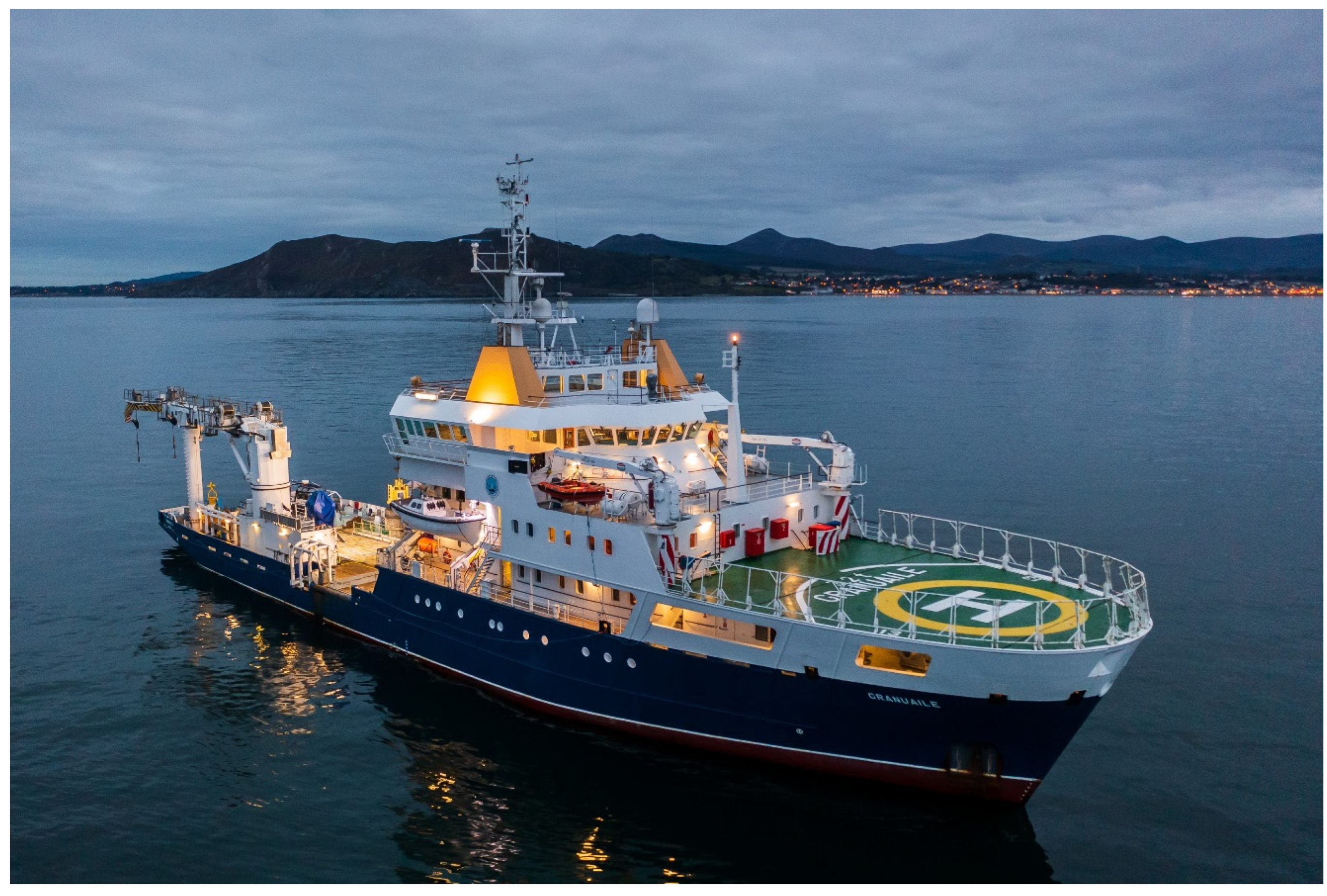
2.1. Vessel and Test Equipment
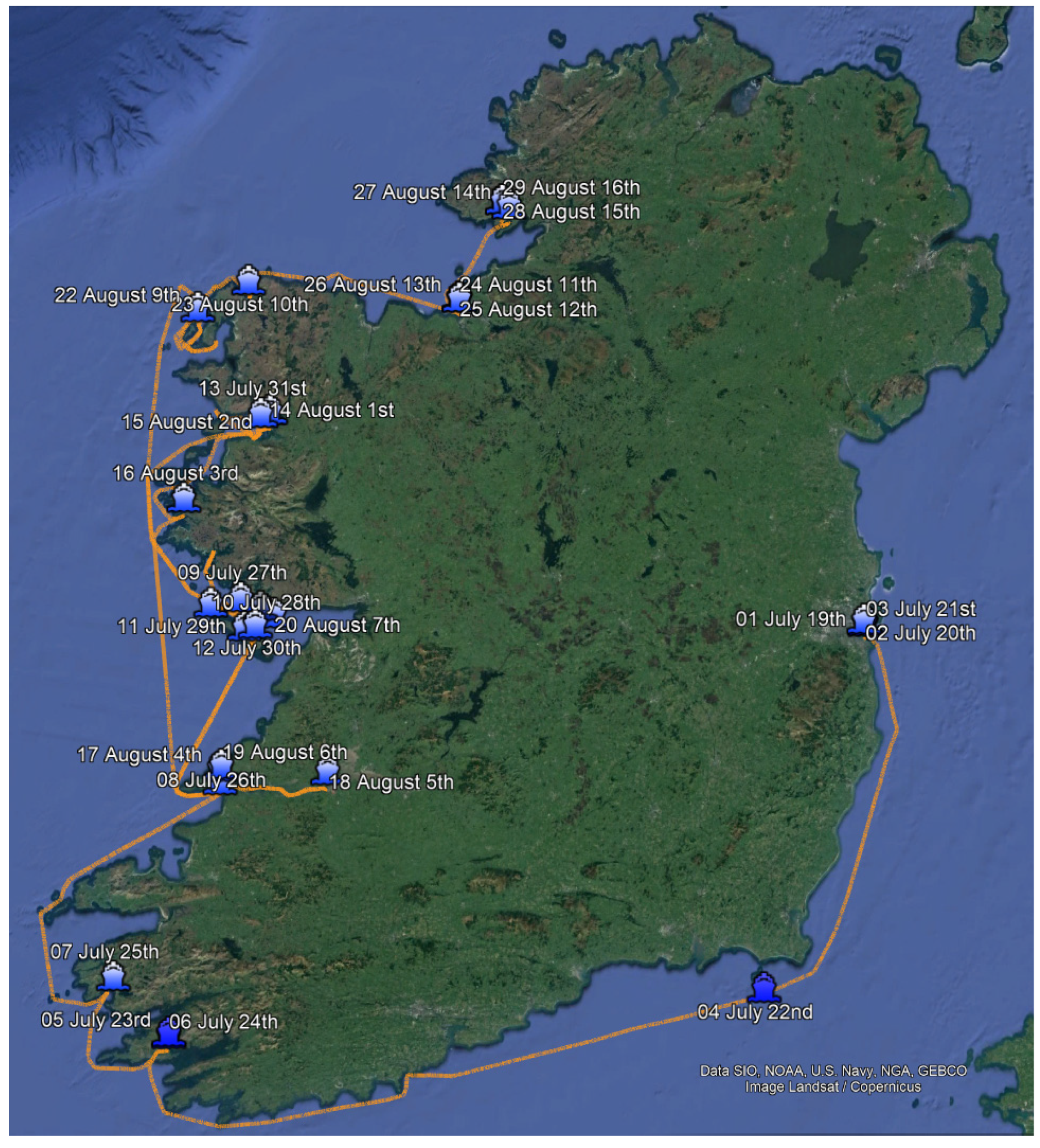
The vessel used for this campaign was the Irish Lights Vessel (ILV) Granuaile (IMO 9192947), as shown in Figure 1. The ILV Granuaile is a buoy-laying vessel, constructed in the year 2000 and currently registered under the flag of Ireland. Her carrying capacity is 1132 t DWT, with a reported draught of 5 m. Her length overall (LOA) is 79.63 m and her width is 16.08 m. The vessel is owned by the Commissioners of Irish Lights, which is the statutory body vested with the superintendence and management of all lighthouses, buoys and beacons throughout Ireland and Northern Ireland. The powers and obligations of the Commissioners of Irish Lights are set out in legislation in both the UK and Ireland [14].
The ILV Granuaile was already equipped with experimental GLA equipment, including a Galileo E6 capable GNSS antenna, a TNC cable from the antenna to the equipment room, a GNSS amplifier to compensate for cable losses, a cellular router for internet connectivity over LTE/5G and an Ethernet switch to connect devices to the cellular router. Spaceopal installed additional equipment, including a Galileo HAS User Terminal and a laptop used for configuring, downloading data from the User Terminal and uploading data to the Spaceopal FTP server. Some minor equipment, such as a power strip and cables, were also added.
The User Terminal is the first Galileo HAS receiver developed for this new service [15]. It hosts a real-time Galileo HAS user algorithm, capable of operating in dual- and triple-frequency Galileo-only and Galileo and GPS modes, with corrections obtained from either the E6-B signal or the internet. In 2021, Spaceopal and partners developed the first HAS receiver in only 12 months for EUSPA to support HAS initial service deployment.
The Galileo HAS User Terminal is a portable, configurable and autonomous device designed to calculate a single- (Galileo) or multi-constellation (Galileo + GPS) Galileo HAS and OS position, velocity and time (PVT) solution. The User Terminal can be configured to retrieve Galileo HAS corrections either from the Galileo SiS over E6-B or Internet Data Distribution (IDD) over NTRIP in RTCM3 format. The terminal operates with various frequency combinations that can be configured by the user. It is a robust device with an IP64 rating and offers multiple communication and logging capabilities. The requirements for the High Accuracy User Terminal targeted a wide range of applications, configurations, dynamics and environmental constraints.
The Galileo HAS User Algorithm [15] is a real-time PPP algorithm that processes the corrections delivered by Galileo HAS Initial Service (orbit/clock corrections and only code biases) and calculates position and velocity referred to the GTRF (Galileo Terrestrial Reference Frame), time-stamped with respect to the GST (Galileo System Time). It uses Galileo L-Band observables and, in the case of a multi-constellation configuration, GPS L-Band observables as well. The Galileo HAS User Algorithm estimation technique is an Extended Kalman filter (EKF) with state predictions and state updates to improve convergence and accuracy as it finds an optimum trade-off between measurement model and state space model by minimizing the variance of the updated states. The User Algorithm processing follows an uncombined, satellite-to-satellite single-differenced (SD) processing. The algorithm has preprocessing steps including outlier detection and elimination of single satellite failure for each GNSS constellation with RAIM/DIA and of detection and elimination of complete GNSS constellation outages. Preprocessing also addresses cycle slip detection and correction by using time-differenced Melbourne–Wübbena combination and ionosphere-free phase combination. With this set of techniques, the proposed UA provides robustness to different fault behaviors on the site of satellites, the level of the correction service, and of the receiver and its environment.
Previous work on the Galileo HAS user performance from other developments and using different algorithms can be found in [16,17,18,19].

2.2. Operations

Figure 2 presents the position of ILV Granuaile at 0.00 h UTC every day throughout the campaign, which ran from 19 July to 16 August 2023 (days 1–29), and the route followed by the vessel during this period.
The User Terminal was activated on 19 July 2023 in Dun Laoghaire and turned off in Killibegs on 17 August. Spaceopal monitored the User Terminal operations daily and uploaded data to the FTP server. Initially, the User Terminal was configured to operate at 1 Hz sampling rate and elevation mask of 5 degrees in Galileo E1/E5a + GPS L1/L2C mode. On 3 August, the operating mode was changed to Galileo E1/E5a/E6-B + GPS L1/L2C, and the User Terminal was restarted at 15.00 UTC on that day.

2.3. Reference Trajectory

The vessel’s reference trajectory was calculated using NovAtel GrafNav post-processing software (version 8.90) [20]. GrafNav was configured in kinematic differential mode, and data was processed in both forward and backward directions. The software was supplied with raw GNSS observables from the Galileo HAS User Terminal and selected reference stations within the HxGN SmartNet network. Typical baseline lengths were suboptimal, averaging around 40 km but occasionally extending up to 65 km. The GrafNav processing was performed by GRAD.

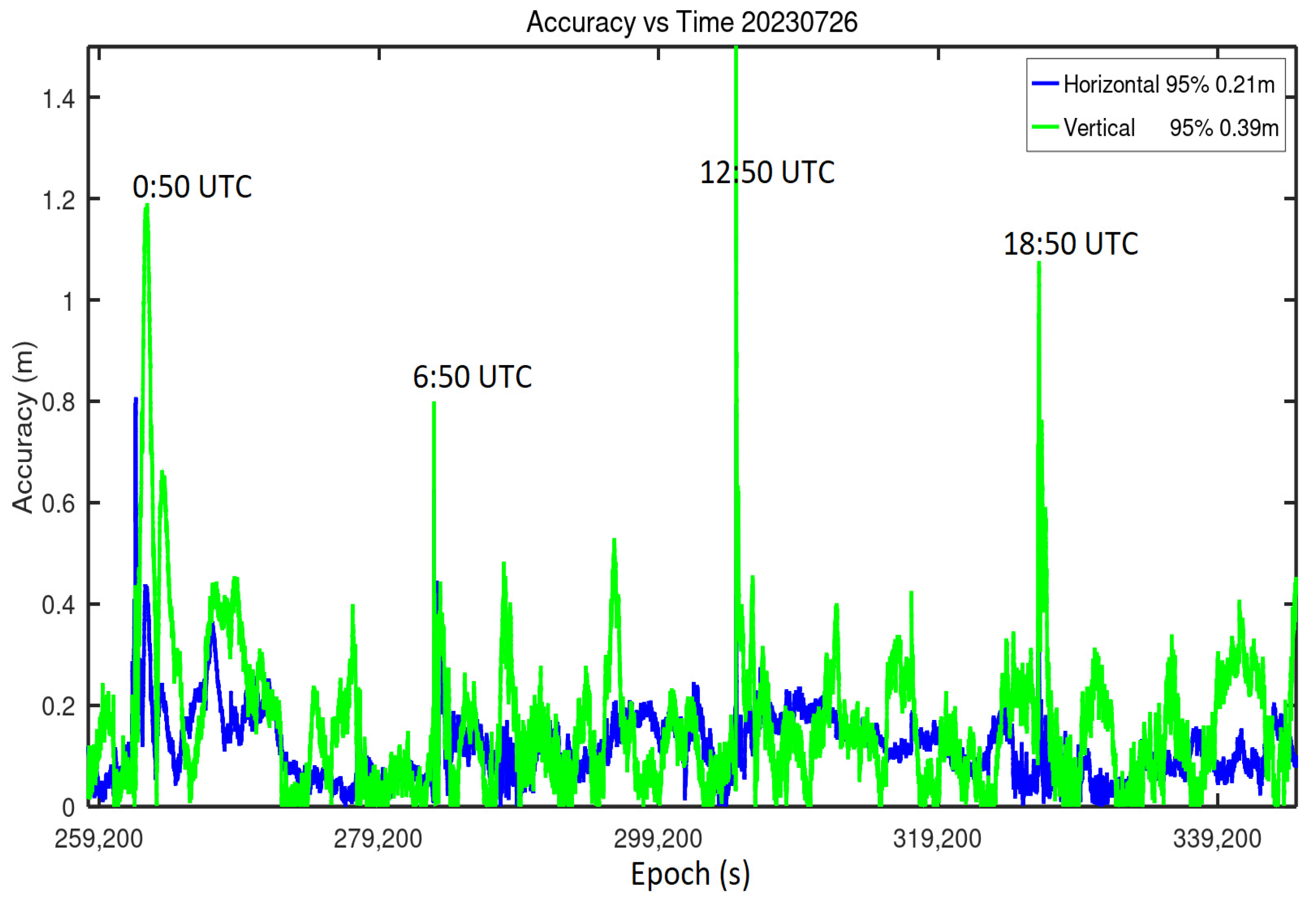
2.4. Performance Metrics

The Galileo HAS position calculated by the Galileo HAS User Terminal was compared to the reference trajectory position for each epoch calculated using GrafNav. The differences in the horizontal and vertical position in the local tangent plane are the horizontal and vertical position error for each epoch, respectively. Table 3 identifies and defines the performance metrics [1] relevant to the campaign.

3. Results

The accuracy results for the tests in this article are a comparison between the real-time position (XYZ coordinates) delivered by the Galileo User Terminal (stored in files) with the postprocessing coordinates from the reference trajectory. The difference between the reference and real time positions projected to the horizontal tangent plane of the reference position is the horizontal error and the difference projected to the vertical plane is the vertical error. A characterization of the 68% and 95% percentile is performed for both horizontal and vertical errors to obtain the horizontal and vertical accuracy.

3.1. Performance Results

Table 4 presents the results of the position accuracy assessment. The performance targets were initially defined based on the information in the Galileo HAS info note [2], specifying a requirement of 0.20 m (95%) for horizontal accuracy and 0.40 m (95%) for vertical accuracy. Additionally, a second performance level was defined, with requirements of 0.15 m (68%) for horizontal accuracy and 0.20 m (68%) for vertical accuracy, as described in the Galileo HAS SDD [1].
The User Terminal was initially configured to operate in Galileo E1/E5a + GPS L1/L2C mode, starting from 19 July. On 3 August, the operating mode was changed to Galileo E1/E5a/E6-B + GPS L1/L2C. These two days have been excluded from the assessment to mitigate the impact of the convergence process. However, it is important to note that the results presented in this section include periods of suspected external RF interference, as described further below.
Table 5 presents the position availability results from the campaign. Two sets of thresholds were selected in line with the accuracy targets introduced previously. The results have not been modified to remove any possible external Radio Frequency (RF) interference effects.

3.2. Analysis of Results

In order to evaluate the goodness of the accuracy performance in Table 4, results are compared to the performance targets of 0.15 m (68%) for horizontal accuracy and 0.20 m (68%) for vertical accuracy described in Table 2. When considering all epochs for all days together, the 68% horizontal accuracy is 0.14 m and 68% vertical accuracy is 0.17 m 68%. Both values meet their respective performance targets in Table 2 even if the performance targets are specified for static users. This indicates positive overall accuracy results and margin for users in the existing performance targets for Galileo HAS Initial Service. Table 4 also presents results compared to the 0.20 m (95%) for horizontal accuracy and 0.40 m (95%) for vertical accuracy described in Table 1 for the future Galileo HAS full service Level 1 and Level 2. In this case, results are slightly over the threshold reaching 0.29 m horizontal 95% and 0.42 m vertical 95%. These values are not committed for the current phase (Initial Service), but for the full service of Galileo HAS to be rolled out in the future.
Even if the overall accuracy results are positive, an analysis of the instantaneous horizontal and vertical position error was required, because errors presented 6 h periodic heavy degradations with eventual loss of the position for a few seconds, as in Figure 3.
A first investigation indicated that, every day, at approximately 0.50 UTC, 6.50 UTC, 12.50 UTC and 18.50 UTC, the User Terminal observations were interrupted for a few seconds for GNSS bands L1 and L2, but not for L5. Having discarded any issues in the User Terminal and the Galileo HAS corrections through the nominal equipment checks and correction analysis, the most likely cause was coming from an external source onboard. As a cargo vessel with a gross tonnage exceeding 300 tons, ILV Granuaile is required to carry Long Range Identification and Tracking (LRIT) equipment. The LRIT system enables global vessel identification and tracking, enhancing shipping security and contributing to safety and marine environment protection.
Shipborne LRIT equipment transmits within the 1600 MHz to 1630 MHz frequency band, which is close to the GPS/Galileo L1/E1 band (centred at 1575.42 MHz), and it operates at a power level exceeding 1.5 W. These transmissions occur every six hours. Every day at approximately 0.50 UTC, 6.50 UTC, 12.50 UTC and 18.50 UTC, the User Terminal observations were interrupted for a few seconds.
The LRIT antenna is mounted 2.5 m below the GNSS antenna used in the campaign. The recommended separation distance between an LRIT antenna and any GNSS antenna is 30 m. While it is not confirmed that LRIT is responsible for the interference events, there is a high likelihood that it is the cause. In Figure 3, the reader can observe an example of the position degradation occurring every 6 h.
The impact of these events on overall performance is significant, happening every 6 h and resulting in a notable degradation of position accuracy for an undetermined duration. Performance is affected not only during the event, but also after it has finished, primarily because the selected positioning technique for Galileo HAS, Precise Point Positioning, uses a Kalman filter. These events also impacted the calculation of the reference trajectory using GrafNav.
The test campaign results demonstrate the performance of the Galileo HAS User Terminal including the adverse effects of the high-power interference likely originating from the LRIT system antenna onboard the vessel. Table 6 shows the results after removing 1-hour periods at 0.50 h, 6.50 h, 12.50 h and 18.50 h to mitigate the impact of the interference, classified according to the different phases of navigation. The 1 h removal cannot completely remove the impact of interference because the selected positioning technique for Galileo HAS, Precise Point Positioning, uses an Extended Kalman filter (EKF) and effects are carried over until a device restart.
Results in Table 5 present the position availability results from the campaign. The very same two sets of thresholds were selected in line with the accuracy targets previously introduced. The availability for the first threshold (0.15 m horizontal/0.20 m vertical) for all epochs for all days together is 55% with a minimum of 36% and maximum of 89%, and the second threshold (0.20 m horizontal/0.40 m vertical) is 81% with a minimum of 62% and maximum of 97%. The availability values are too dissimilar between days. When looking into the results, the variation between days seemed to be related to the type of navigation for each specific day. ILV Granuaile spent several days anchored for the full day, whereas for others it was navigating through coastal waters or open sea. The results indicate better performance in scenarios involving slow motion, which is of particular relevance for mooring and pilotage applications. Values for these slow-dynamics applications reach a horizontal accuracy of 0.22 m 95% and 0.13 m 68%.
It is acknowledged that the variations in estimated performance seen in Table 6 may in part be related to the vessel’s distance from the HxGN SmartNet station(s).

4. Discussion

This article presented the results of the first Galileo HAS testing campaign conducted at sea using a buoy-laying vessel temporarily equipped with a Galileo HAS User Terminal. Whereas GNSS standalone and augmentation have been used in marine navigation for a long period of time, the operational declaration of Galileo HAS in January 2023 opens new opportunities for decimeter level applications.
In this test campaign, results were particularly impacted by onboard vessel interference, but even under this harsh radio frequency environment, the accuracy reached the performance targets stated in the Galileo HAS SDD [1].
The overall satisfaction with accuracy and availability results is fostered when it is considered the negative impact of the high-power interference likely generated by LRIT equipment onboard the vessel. LRIT broadcasts, occurring daily at 0.50 h, 6.50 h, 12.50 h and 18.50 h, were comparatively strong, with the LRIT antenna located just 2.5 m from the GNSS antenna making mitigation challenging. One significant feature of the underlying Galileo HAS positioning algorithm is the need of a continuous flow of GPS and Galileo observations, otherwise the EKF is restarted. Restarts imply positioning solution convergence periods during which accuracy is degraded compared to steady-state situations. Even on this environment, values for horizontal accuracy reached 0.29 m 95% and 0.14 m 68%. The article also presents better values after removing interference periods when horizontal accuracy reached 0.22 m 95% and 0.13 m 68%. These results are in line with the expectations outlined in the Galileo HAS Service Definition Document (SDD). Future work shall ensure RF interference-free environments.
The article provided additional assessments for different phases of navigation, demonstrating better performance in slow-motion scenarios, particularly relevant to mooring and pilotage applications.
The Galileo HAS will evolve in the near future to Phase 1, meeting full performance targets, and subsequently to Phase 2, introducing additional corrections in Europe. This will enable enhanced performance. Furthermore, fine-tuning receiver algorithms for maritime applications, with specific assumptions for the EKF, may bring significant improvement.

Author Contributions

Conceptualization: M.L.-M., P.P. and E.G.; Materials and methods: P.P., J.S. and R.B.; Results: P.P. and J.S.; Review and editing: M.L.-M., P.P. and E.G. All authors have read and agreed to the published version of the manuscript.

Funding

The work by Spaceopal was executed in the frame of the Galileo Adoption Plan 2023 as part of the Galileo Service Operator (GSOp) framework contract funded by European Union Agency for the Space Program (contract GSA/CD/14/14).

Institutional Review Board Statement

Not applicable.

Informed Consent Statement

Not applicable.

Data Availability Statement

Data used for the preparation of this paper is available for free. Please contact the corresponding author in case you would like to access the raw data.

Acknowledgments

The authors would like to thank Commissioners of Irish Lights for permitting the installation of equipment on the ILV Granuaile.

Conflicts of Interest

M.L. is an employee of European Union Agency for the Space Program. P.P., E.G are employed by Spaceopal GmbH. J.S. and R.B. declare no conflict of interest.

Note

1
General Lighthouse Authorities of the UK and Ireland.

References

  1. European Union. Galileo High Accuracy Service-Service Definition Document (HAS SDD), Issue 1.0. Available online: https://www.gsc-europa.eu/sites/default/files/sites/all/files/Galileo-HAS-SDD_v1.0.pdf (accessed on 1 September 2023).
  2. European Union. Galileo High Accuracy Service–Info Note, Issue 1.0. Available online: https://www.gsc-europa.eu/sites/default/files/sites/all/files/Galileo_HAS_Info_Note.pdf (accessed on 1 September 2023).
  3. European Union. Galileo High Accuracy Service–Signal-in-Space Interface Control Document (HAS SiS ICD), Issue 1.0. Available online: https://www.gsc-europa.eu/sites/default/files/sites/all/files/Galileo_HAS_SIS_ICD_v1.0.pdf (accessed on 1 September 2023).
  4. European Union. Galileo High Accuracy Service-Internet Data Distribution Interface Control Document (HAS IDD ICD), Issue 1.0. Available online: https://www.gsc-europa.eu/galileo/services/galileo-high-accuracy-service-has/internet-data-distribution-registration-form (accessed on 1 September 2023).
  5. European Union. Galileo Open Service-Service Definition Document (OS SDD), Issue 1.2. Available online: https://www.gsc-europa.eu/sites/default/files/sites/all/files/Galileo-OS-SDD_v1.3.pdf (accessed on 1 September 2023).
  6. Department of Defence, USA. Global Positioning System Standard Positioning Service Performance Standard (GPS SPS), 5th ed.; Department of Defence: Washington, DC, USA, 2020. [Google Scholar]
  7. European Union. European GNSS (Galileo) Services–Open Service–Quarterly Performance Report April June 2023, Issue 1.0. Available online: https://www.gsc-europa.eu/electronic-library/performance-reports/galileo-open-service-os (accessed on 1 September 2023).
  8. Renfro, B.A.; Stein, M.; Reed, E.B.; Villalba, E. An Analysis of Global Positioning System Standard Positioning Service Performance for 2020; Space and Geophysics Laboratory Applied Research Laboratories; The University of Texas at Austin: Austin, TX, USA, 2020. Available online: https://www.gps.gov/systems/gps/performance/ (accessed on 1 September 2023).
  9. European Union. European GNSS (Galileo) Services–High Accuracy Service (HAS)–Quarterly Performance Report April June 2023, Issue 1.0. Available online: https://www.gsc-europa.eu/electronic-library/performance-reports/galileo-high-accuracy-service-has (accessed on 1 September 2023).
  10. Pandele, A.; Croitoru, A.; Hulea, A.; Costel, C.; Radutu, A.; Porretta, M.; Buist, P.J.; Andrescu, D.; Dutu, L.; Dragasanu, C.; et al. Galileo and GPS Performances in the Maritime Environment. In Proceedings of the 33rd International Technical Meeting of the Satellite Division of The Institute of Navigation (ION GNSS+ 2020), Online, 22–25 September 2020; pp. 896–919. [Google Scholar]
  11. Morán, J.; Lacarra, E.; Vázquez, J.; Sánchez, M.A.; Cantos, F.; Horváth, T. EDAS for a DGPS Maritime Service: EGNOS Based VRS Performance with Pre-Broadcast Integrity Monitoring. In Proceedings of the 29th International Technical Meeting of the Satellite Division of The Institute of Navigation (ION GNSS+ 2016), Portland, OR, USA, 12–16 September 2016; pp. 3481–3493. [Google Scholar]
  12. González, R.; Lacarra, E.; López, M.; Heikonen, K. EGNOS Performance Along Finnish Coast. TransNav. Int. J. Mar. Navig. Saf. Sea Transp. 2021, 15, 551–556. [Google Scholar] [CrossRef]
  13. Tegedor, J.; Ørpen, O.; Melgard, T.; Łapucha, D.; Visser, H. G4 Multi-constellation Precise Point Positioning Service for High Accuracy Offshore Navigation. TransNav. Int. J. Mar. Navig. Saf. Sea Transp. 2017, 11, 425–429. [Google Scholar] [CrossRef]
  14. Commissioners of Irish Lights. Available online: www.irishlights.ie (accessed on 1 September 2023).
  15. González, E.; Pintor, P.; Senado, A.; Dhital, N.; Ostolaza, J.; Hernández, C.; de Blas, J. Galileo High Accuracy Service (HAS) Algorithm and Receiver Development and Testing. In Proceedings of the 35th International Technical Meeting of the Satellite Division of The Institute of Navigation (ION GNSS+ 2022), Denver, CO, USA, 19–23 September 2022; pp. 836–851. [Google Scholar]
  16. Pintor, P.; González, E.; Bohlig, P.; Sperl, A.; Ostolaza, J.; Hernández, C.; Vazquez, J.; de Blas, J.; Lagrasta, S. Testing the Galileo High Accuracy Service (HAS) User Terminal. In Proceedings of the 2023 European Navigation Conference (ENC 2023), Noordwijk, The Netherlands, 31 May–2 June 2023. [Google Scholar]
  17. Fernandez-Hernandez, I.; Chamorro-Moreno, A.; Cancela-Diaz, S.; Calle-Calle, J.D.; Zoccarato, P.; Blonski, D.; Senni, T.; de Blas, F.J.; Hernández, C.; Simón, J.; et al. Galileo high accuracy service: Initial definition and performance. GPS Solut. 2022, 26, 65. [Google Scholar] [CrossRef]
  18. Chamorro, A.; Cancela, S.; García, A.J.; Calle, D.; Fernández-Hernández, I.; de Blas, F.J.; Hernández, C. Early Demonstration of Galileo HAS User Performances. In Proceedings of the 35th International Technical Meeting of the Satellite Division of The Institute of Navigation (ION GNSS+ 2022), Denver, CO, USA, 19–23 September 2022; pp. 828–835. [Google Scholar]
  19. Naciri, N.; Yi, D.; Bisnath, S.; de Blas, F.J.; Capua, R. Assessment of Galileo High Accuracy Service (HAS) test signals and preliminary positioning performance. GPS Solut. 2023, 27, 73. [Google Scholar] [CrossRef] [PubMed]
  20. Novatel. A NovAtel Precise Positioning Product. In Waypoint Software 8.90 User Manual; Revision v10; NovAtel Inc.: Calgary, AB, Canada, 2020. [Google Scholar]
Figure 1. ILV Granuaile.
Jmse 11 02375 g001
Figure 2. ILV Granuaile position at 0.00 h UTC every day and the route followed.
Jmse 11 02375 g002
Figure 3. Real-time User Terminal accuracy vs. time using Galileo HAS corrections for 26 July 2023. Periodic degradation occurs every 6 h.
Jmse 11 02375 g003
Table 1. Main HAS full service features and target performances for Service Level 1 and 2 at user level [2].
High Accuracy ServiceService Level 1Service Level 2
CoverageGlobalEuropean Coverage Area (ECA)
Type of correctionsPrecise Point Positioning (PPP)–orbit, clock, biases (code and phase)PPP–orbit, clock, biases (code and phase) incl. atmospheric corrections
Format of correctionsOpen format similar to Compact-SSR (CSSR)Open format similar to Compact-SSR (CSSR)
Dissemination of correctionsGalileo E6B using 448 bits per satellite per second/terrestrial (internet)Galileo E6B using 448 bits per satellite per second/terrestrial (internet)
Supported constellationsGalileo, GPSGalileo, GPS
Supported frequenciesE1/E5a/E5b/E6/E5AltBOC
L1/L5/L2C
E1/E5a/E5b/E6/E5AltBOC
L1/L5/L2C
Horizontal accuracy 95%<20 cm<20 cm
Vertical accuracy 95%<40 cm<40 cm
Convergence time<300 s<100 s
Availability99%99%
User helpdesk24 h/724 h/7
Table 2. Galileo HAS positioning accuracy typical performance from Galileo HAS SDD [1].
Figure of MeritTypical
Performance
Conditions and Constrains
HAS
horizontal positioning accuracy
≤15 cm
for Galileo + GPS
68th percentile.
In any 24 h period.
For combination of signals: E1/E5a + L1/L2C, E1/E5b + L1/L2C, E1/E5a/E6-B + L1/L2C
Evaluated with the performance characterization user algorithm described in Galileo HAS SDD [1].
At least eight satellites in view above an elevation of 5 degrees for Galileo + GPS users in open sky conditions
Static user conditions.
Using clock, orbit and code biases
At the Average over all User Locations of the service area (specified in Galileo HAS SDD [1] Section 3.1).
Usage assumptions as per Galileo HAS SDD [1] Section 2.4.
HAS
vertical
positioning
accuracy
≤20 cm
for Galileo + GPS
Table 3. Performance metrics.
Performance MetricsDefinition
Position errorDefined as the instantaneous difference between the reference horizontal (respectively vertical) position and the horizontal (respectively vertical) position estimated by the user receiver at any time after convergence has been achieved.
Horizontal/vertical position accuracyDefined as statistical characterization of the position horizontal error (respectively vertical) over a reference period of time.
Position availabilityDefined as percentage of time, over a specified reference period, during both horizontal and vertical position error remain below predefined thresholds.
Table 4. Position accuracy in meters using Galileo HAS.
DateGranuaile Location at 0.00 UTCHorizontal 68% (m)Vertical 68% (m)Horizontal 95% (m)Vertical 95% (m)
20 July 2023Dun Laoghaire0.130.140.20.28
21 July 2023Dun Laoghaire0.160.130.300.32
22 July 2023Kilmore Quay0.120.190.260.44
23 July 2023Bere Island0.090.120.190.26
24 July 2023Bere Island0.170.20.380.41
25 July 2023Ballingskelig Bay0.180.280.310.60
26 July 2023Mouth of Shannon estuary0.140.190.220.40
27 July 2023Aran Islands0.130.160.290.38
28 July 2023Aran Islands0.150.260.300.49
29 July 2023Aran Islands0.150.230.250.50
30 July 2023Aran Islands0.120.200.210.33
31 July 2023Clew Bay0.160.200.380.65
1 August 2023Clew Bay0.150.210.260.46
2 August 2023Clew Bay0.180.150.580.43
4 August 2023Mouth of Shannon Estuary0.140.280.270.5
5 August 2023Foynes0.120.200.210.29
6 August 2023Mouth of Shannon Estuary0.190.180.310.43
7 August 2023Aran Islands0.130.140.180.39
8 August 2023Aran Islands0.160.160.280.38
9 August 2023Inishkea Islands0.130.160.220.38
10 August 2023Broadhaven bay0.130.180.260.43
11 August 2023Sligo0.160.200.390.5
12 August 2023Sligo0.180.180.290.45
13 August 2023Sligo0.180.220.520.51
14 August 2023Killibegs0.120.090.220.22
15 August 2023Killibegs0.130.110.240.21
16 August 2023Killibegs0.080.090.180.19
All days0.140.170.290.42
Table 5. Position availability using Galileo HAS.
DateGranuaile Location at 0.00 UTCPosition Availability %
H 0.2 m V 0.4 m
Position Availability %
H 0.15 m V 0.20 m
20 July 2023Dun Laoghaire9464
21 July 2023Dun Laoghaire7654
22 July 2023Kilmore Quay8658
23 July 2023Bere Island9685
24 July 2023Bere Island7151
25 July 2023Ballingskelig Bay6236
26 July 2023Mouth of Shannon estuary8953
27 July 2023Aran Islands8162
28 July 2023Aran Islands7541
29 July 2023Aran Islands8345
30 July 2023Aran Islands9261
31 July 2023Clew Bay7752
1 August 2023Clew Bay7850
2 August 2023Clew Bay6749
4 August 2023Mouth of Shannon Estuary7639
5 August 2023Foynes9472
6 August 2023Mouth of Shannon Estuary6945
7 August 2023Aran Islands9466
8 August 2023Aran Islands8056
9 August 2023Inishkea Islands8963
10 August 2023Broadhaven bay8455
11 August 2023Sligo8147
12 August 2023Sligo7748
13 August 2023Sligo6639
14 August 2023Killibegs9173
15 August 2023Killibegs8968
16 August 2023Killibegs9789
All days8155
Table 6. Accuracy and position availability vs. type of navigation removing 1-h periods at interference epochs.
68% Accuracy Horizontal68% Accuracy Vertical95% Accuracy Horizontal95% Accuracy VerticalPosition Availability %
H 0.15 m V 0.20 m
Position Availability %
H 0.20 m V 0.40 m
Anchored0.130.140.220.346790
Coastal0.120.160.260.386086
Open Sea0.170.150.300.365275
All0.130.150.250.366186
Disclaimer/Publisher’s Note: The statements, opinions and data contained in all publications are solely those of the individual author(s) and contributor(s) and not of MDPI and/or the editor(s). MDPI and/or the editor(s) disclaim responsibility for any injury to people or property resulting from any ideas, methods, instructions or products referred to in the content.

