
Comparative Analysis of Two Assessment Methods for the Geoeducational Values of Geosites: A Case Study from the Volcanic Island of Nisyros, SE Aegean Sea, Greece


Abstract
1. Introduction
2. Materials and Methods
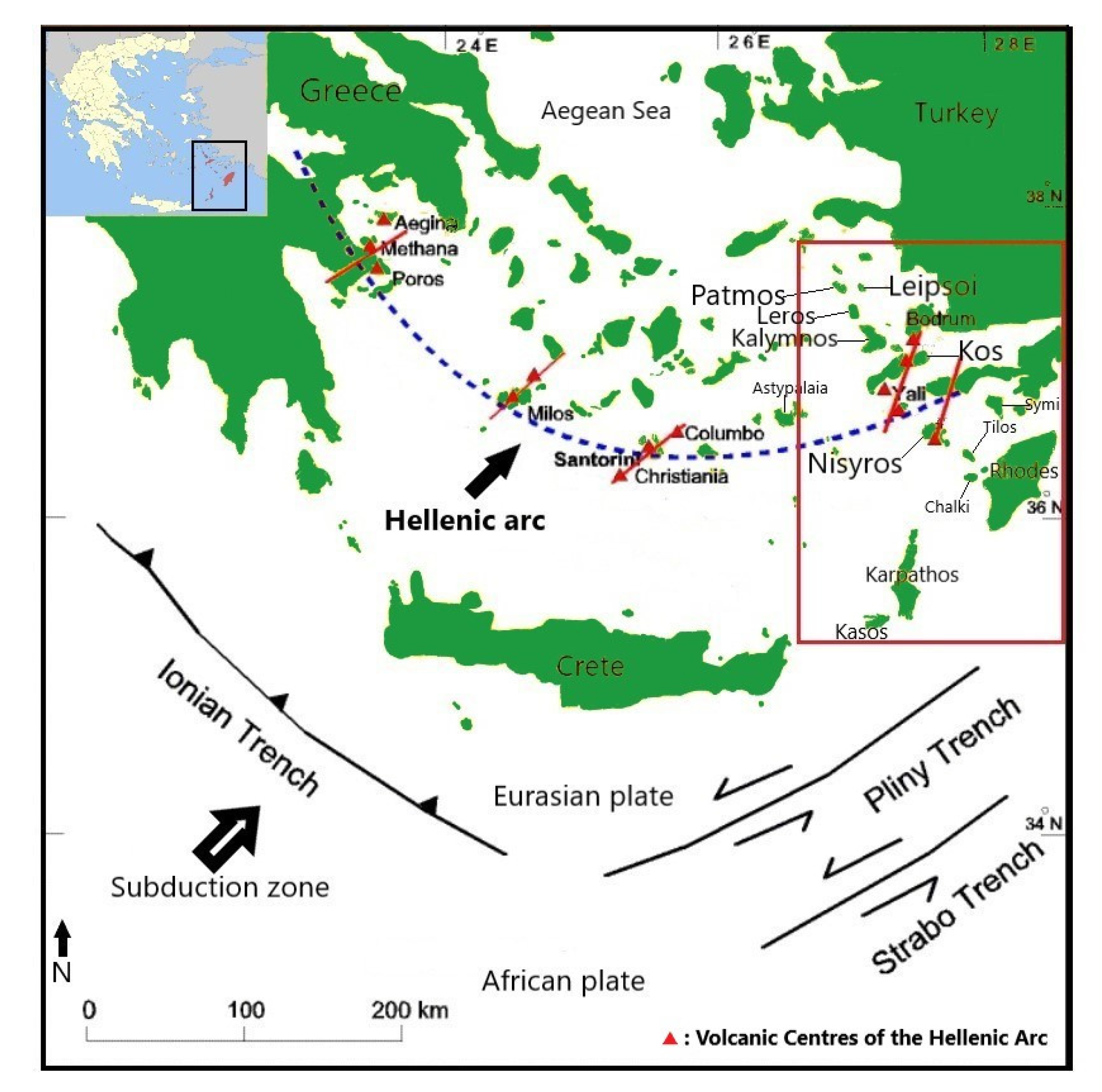
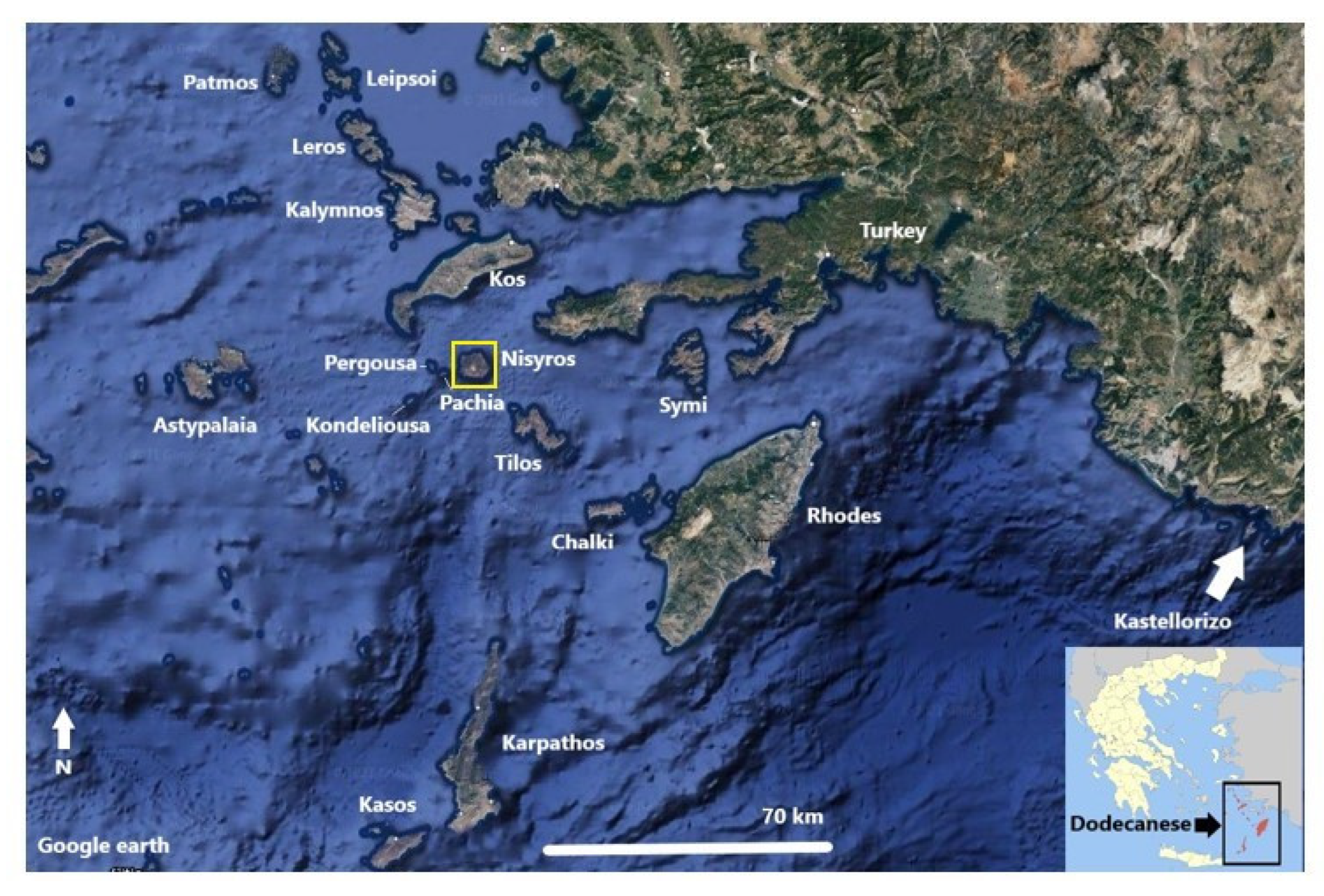
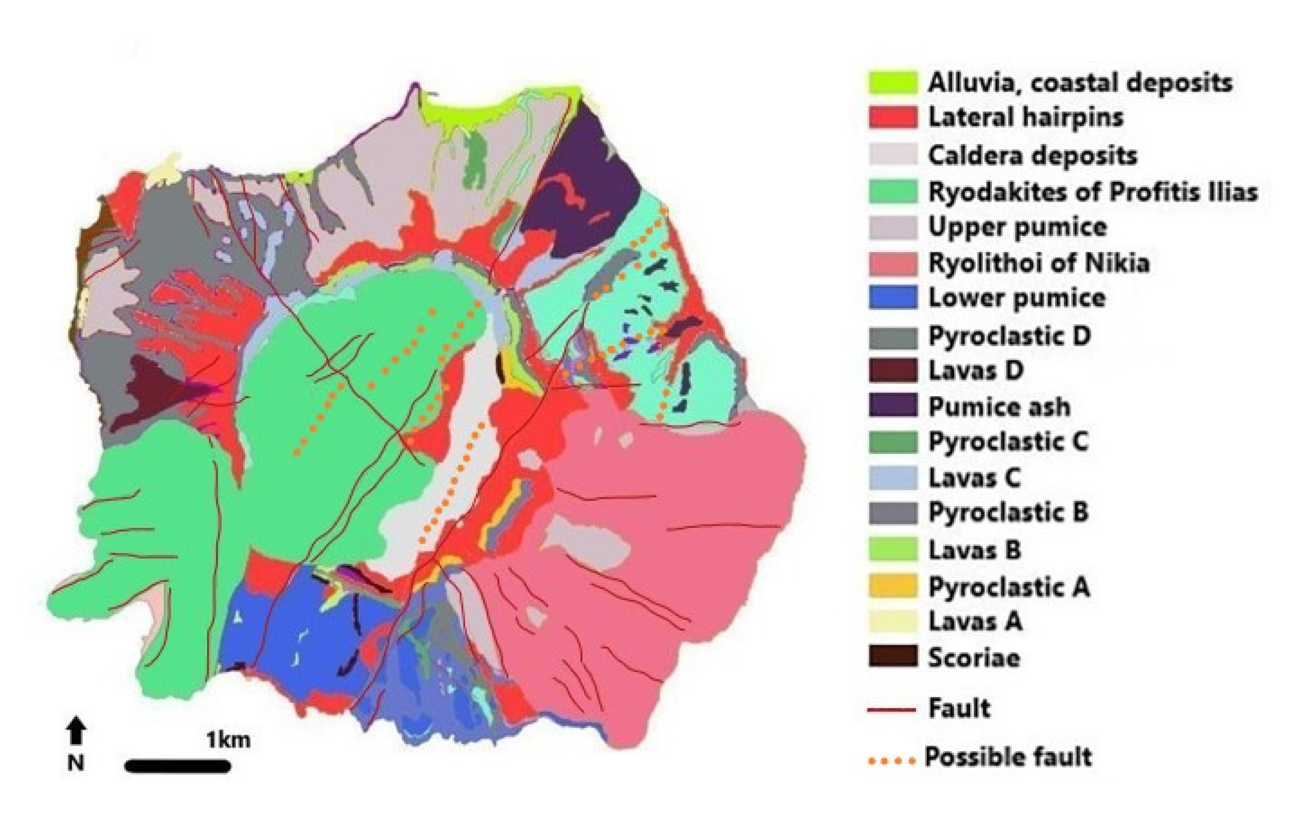
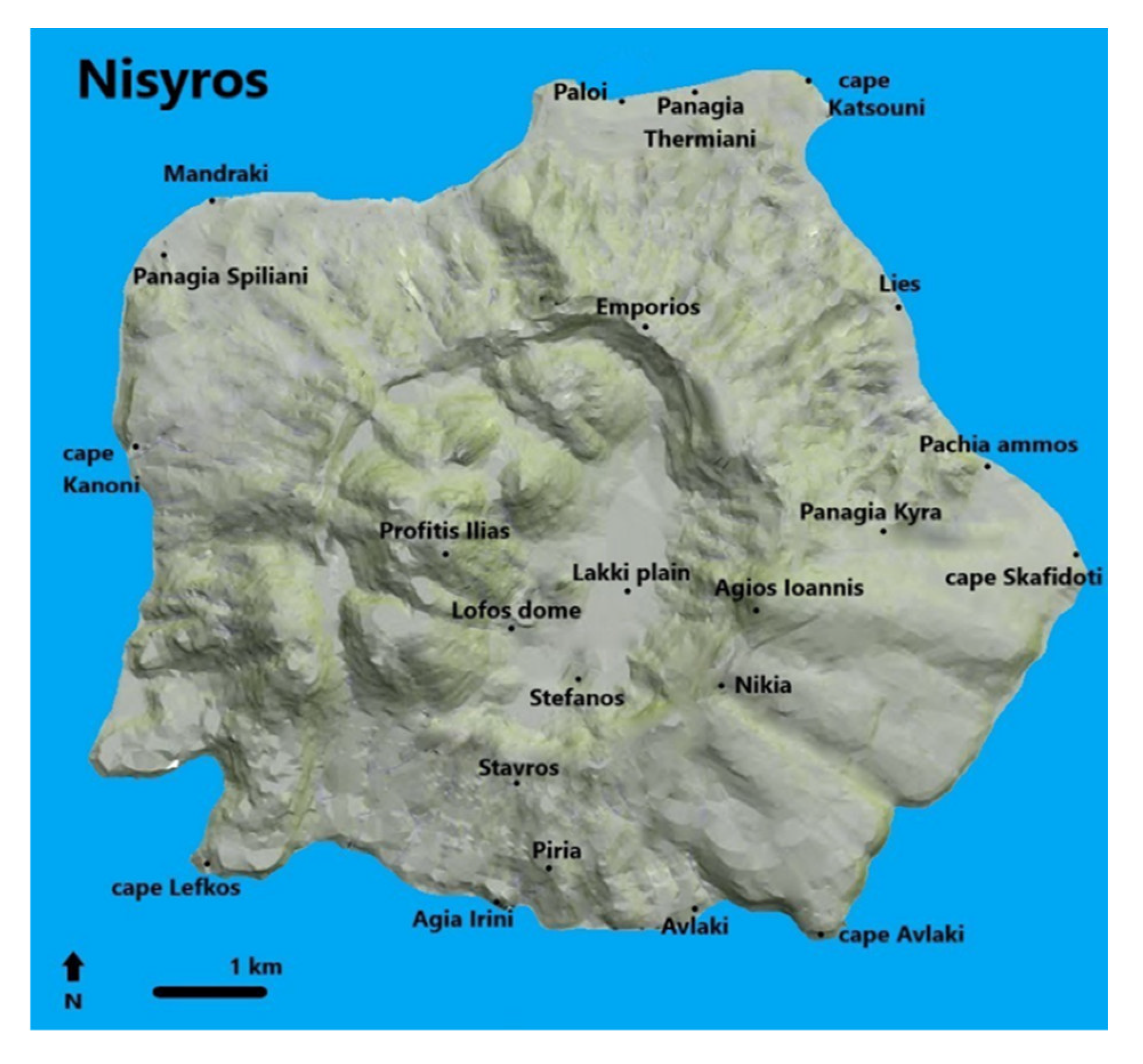
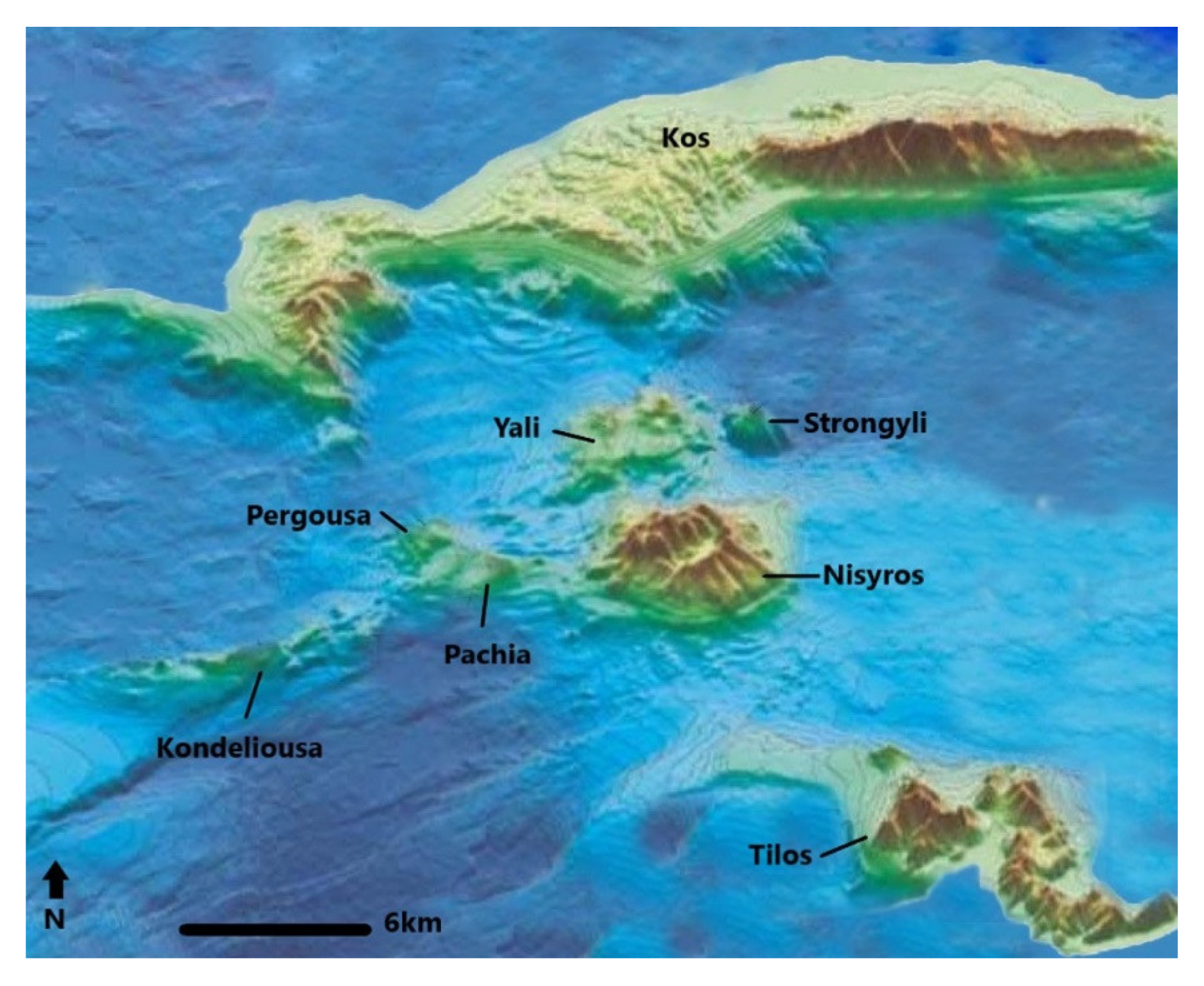
2.1. The Study Area
- (1)
- The lower volcanic rocks visible on the northern coast near Mandraki were built up by an underwater volcano with erupting basaltic and andesitic pillow-lavas;
- (2)
- For more than 100 ka, a 500–700 m high stratovolcano grew on top of these partly submarine lavas;
- (3)
- Two major rhyodacitic plinian eruptions covered the entire island with pyroclastic flows and pumice falls after several eruptive phases of gas and steam explosions;
- (4)
- At 20 ka BP, a major central, vertical collapse of the volcano left a large caldera; and
- (5)
- The western part of the caldera depression was filled with a series of rhyodacitic domes during prehistoric times, the highest of which, Profitis Ilias, rises 698 m a.s.l.
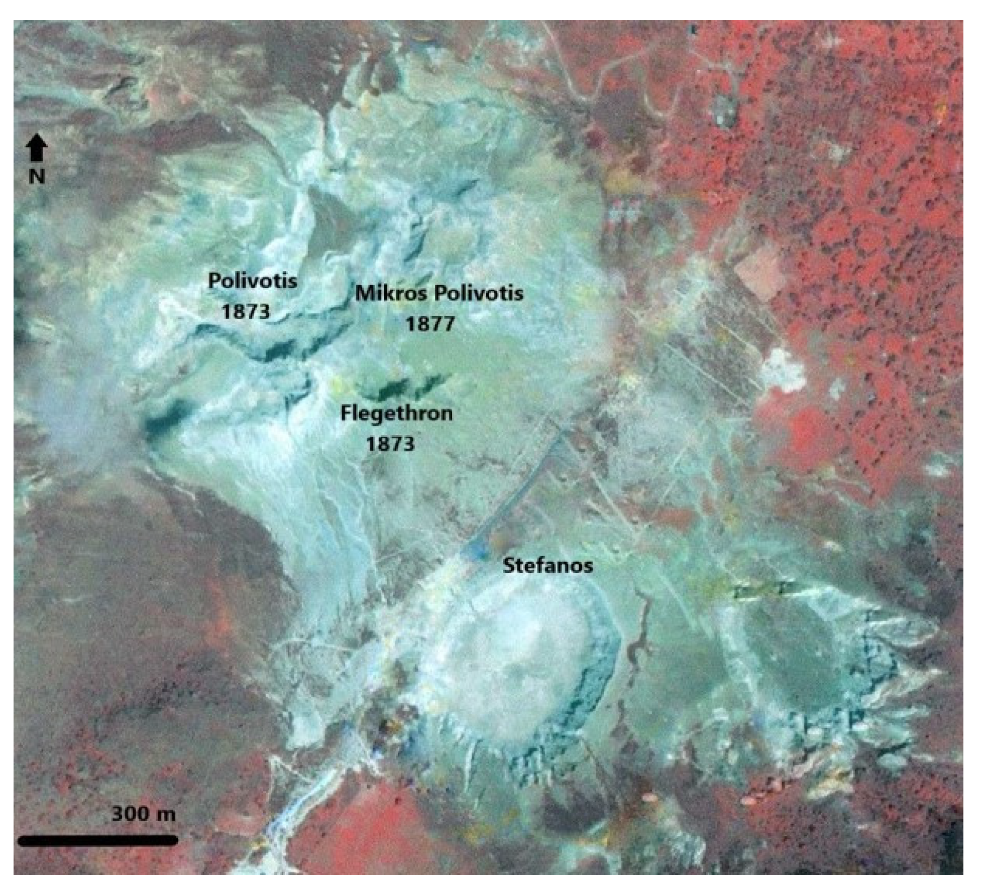
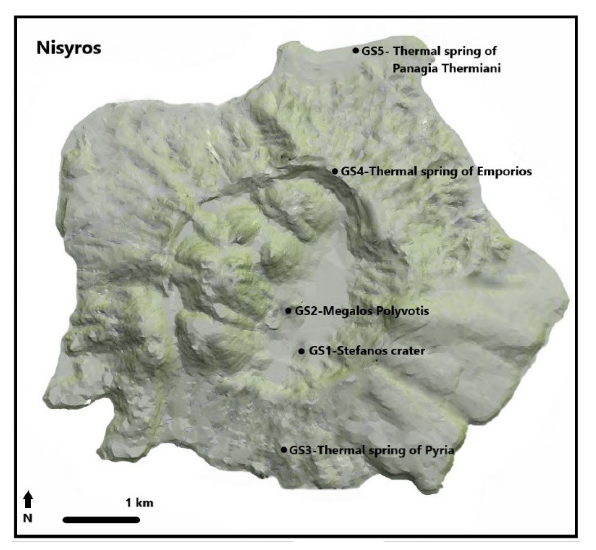
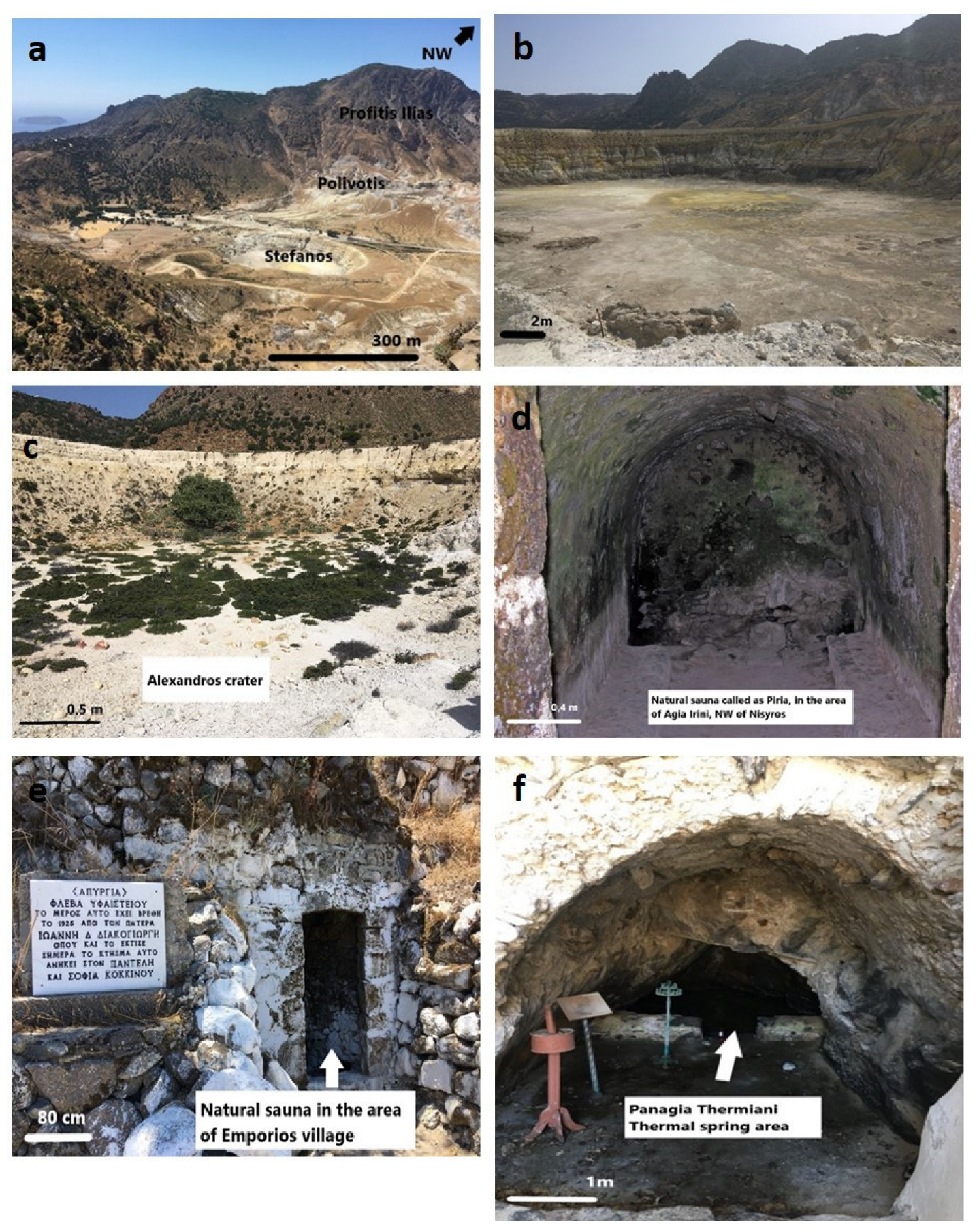
2.2. Geosites
2.3. Methodology
3. Results
3.1. The General-Purpose Model—G-P Method
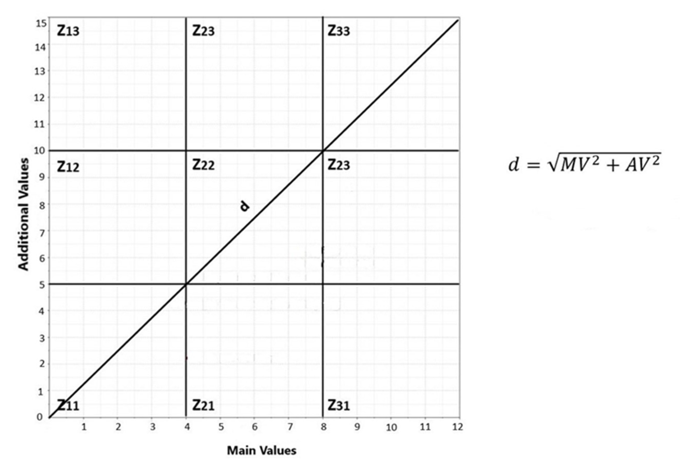
3.2. The M-GAM Method
4. Discussion
Comparative Analysis
5. Conclusions
Author Contributions
Funding
Informed Consent Statement
Data Availability Statement
Acknowledgments
Conflicts of Interest
References
- Martini, G. (Ed.) Actes du premier symposium international sur la protection au patrimonie geologique. In Memoires de la Societe 656 geologique de France, Proceedings of the First Symposium on Earth Heritage Conservation, 11–16 June 1991; numero special 165; Société géologique de France: Digne, France, 1993; 276p. [Google Scholar]
- Zouros, N. The European Geoparks Network. Episodes 2004, 27, 165–171. [Google Scholar]
- Zouros, N.; Valiakos, I. Geoparks Management and Assessment. Bull. Geol. Soc. Greece 2017, 43, 965–977. [Google Scholar] [CrossRef]
- Zwolinski, Z. Geodiversity. In Encyclopedia of Geomorphology; Goudie, A.S., Ed.; Routledge: Oxfordshire, UK, 2004; Volume 1, pp. 417–418. [Google Scholar]
- Sharples, C. Geoconservation in forest management—Principles and practice. Tasforests 1995, 7, 37–50. [Google Scholar]
- Burek, C.V.; Potter, J. Local Geodiversity Action Plans-Sharing Good Practice Workshop, Peterborough, 3 December 2003; English Nature: Peterborough, UK, 2004.
- Burek, C.V.; Potter, J. Local Geodiversity Action Plans-Setting to Context for Geological Conservation; English Nature: Peterborough, UK, 2006.
- Herrera-Franco, G.; Montalván-Burbano, N.; Carrión-Mero, P.; Apolo-Masache, B.; Jaya-Montalvo, M. Research trends in geotourism: A bibliometric analysis using the scopus database. Geosciences 2020, 10, 379. [Google Scholar] [CrossRef]
- Ólafsdóttir, R.; Tverijonaite, E. Geotourism: A systematic literature review. Geosciences 2018, 8, 234. [Google Scholar] [CrossRef]
- Panizza, M. Geomorphosites: Concepts, methods and examples of geomorphological survey. Chin. Sci. Bull. 2001, 46, 4–5. [Google Scholar] [CrossRef]
- Trueba, J.J.G.; Cañadas, E.S. La valoración del patrimonio geomorfológico en espacios naturales protegidos. Su aplicación al parque nacional de los picos de Europa. Bull. Assoc. Span. Geogr. 2008, 47, 175–194, Published online 2008. [Google Scholar]
- De Wever, P.; Baudin, F.; Pereira, D.; Cornee, A.; Egoroff, G.; Page, K. The Importance of Geosites and Heritage Stones in Cities—A Review. Geoheritage 2017, 9, 561–575. [Google Scholar] [CrossRef]
- Reynard, E.; Fontana, G.; Kozlik, L.; Scapozza, C. A method for assessing the scientific and additional values of geomorphosites. Geogr. Helv. 2007, 62, 148–158. [Google Scholar] [CrossRef]
- Ruban, D.A. Quantification of geodiversity and its loss. P. Geologist. Assoc. 2010, 121, 326–333. [Google Scholar] [CrossRef]
- Ruban, D.A. Geotourism—A geographical review of the literature. Tour. Manag. Perspect. 2015, 15, 1–15. [Google Scholar] [CrossRef]
- Skentos, A. Geotopes of Greece. Master’s Thesis, University of Athens, Athens, Greece, 2012. [Google Scholar]
- Brilha, J.B. Inventory and Quantitative Assessment of Geosites and Geodiversity Sites: A Review. Geoheritage 2016, 8, 119–134. [Google Scholar] [CrossRef]
- Henriques, M.H.; Brilha, J. UNESCO Global Geoparks: A strategy towards global understanding and sustainability. Episodes 2017, 40, 349–355. [Google Scholar] [CrossRef]
- Bruschi, V.M.; Coratza, P. Geoheritage and Environmental Impact Assessment (EIA). In Geoheritage: Assessment, Protection and Management; Reynard, E., Brilha, J., Eds.; Elsevier: Amsterdam, The Netherlands, 2018; pp. 251–264. [Google Scholar]
- Zwoliński, Z.; Najwer, A.; Giardino, M. Methods for Assessing Geodiversity. In Geoheritage: Assessment, Protection, and Management; Reynard, E., Brilha, J., Eds.; Elsevier: Amsterdam, The Netherlands, 2018; pp. 27–52. [Google Scholar]
- Drinia, H.; Tsipra, T.; Panagiaris, G.; Patsoules, M.; Papantoniou, C.; Magganas, A. Geological heritage of Syros Island, Cyclades complex, Greece: An assessment and geotourism perspectives. Geosciences 2021, 11, 138. [Google Scholar] [CrossRef]
- Fassoulas, C.; Mouriki, D.; Dimitriou-Nikolakis, P.; Iliopoulos, G. Quantitative Assessment of Geotopes as an Effective Tool for Geoheritage Management. Geoheritage 2012, 4, 177–193. [Google Scholar] [CrossRef]
- Cendrero, A. El patrimonio geológico. Ideas para su protección, conservación y utilización. In El patrimonio geológico. Bases para su valoración, protección, conservación y utilización; Serie Monografías del Ministerio de Obras Públicas, Transportes y Medio Ambiente; Ministerio de Obras Públicas, Transportes y Medio Ambiente: Madrid, Spain, 1996; pp. 17–27. [Google Scholar]
- Cendrero, A. Propuestas sobre criterios para la clasificación y catalogación del patrimonio geológico. In El patrimonio geológico. Bases para su valoración, protección, conservación y utilización; Serie Monografías del Ministerio de Obras Públicas, Transportes yMedio Ambiente; Ministerio de Obras Públicas, Transportes y Medio Ambiente: Madrid, Spain, 1996; pp. 29–38. [Google Scholar]
- Coratza, P.; Giusti, C. Methodological proposal for the assessment of the scientific quality of geomorphosites. Il Quat. 2005, 18, 307–313. [Google Scholar]
- Pralong, J.P.; Reynard, E. A proposal for the classification of geomorphological sites depending on their tourist value. Quaternario 2005, 18, 315–321. [Google Scholar]
- Pereira, P.; Pereira, D.; Alves, M.I.C. Geomorphosite assessment in Montesinho Natural Park (Portugal). Geogr. Helv. 2007, 62, 159–168. [Google Scholar] [CrossRef]
- Bruschi, V.M.; Cendrero, A. Direct and parametric methods for the assessment of geosites and geomorphosites. In Geomorphosites; Reynard, E., Coratza, P., Regolini-Bissig, G., Eds.; Verlag Dr. Friedrich Pfeil: München, Germany, 2009; pp. 73–88. [Google Scholar]
- Reynard, E. The assessment of geomorphosites. In Geomorphosites; Reynard, E., Coratza, P., Regolini Bissig, G., Eds.; Verlag Dr. Friedrich Pfeil: Munchen, Germany, 2009; pp. 63–71. [Google Scholar]
- Pereira, P.; Pereira, D. Methodological guidelines for geomorphosite assessment. Géomorphologie: Relief, processus. Environnement 2010, 16, 215–222. [Google Scholar]
- Bruschi, V.M.; Cendrero, A.; Albertos, J.A.C. A statistical approach to the validation and optimisation of geoheritage assessment procedures. Geoheritage 2011, 3, 131–149. [Google Scholar] [CrossRef]
- Pereira, P.; Pereira, D.I. Assessment of geosites tourism value in geoparks: The example of Arouca Geopark (Portugal). In Proceedings of the 11th European Geoparks Conference, Arouca, Portugal, 19–21 September 2012; pp. 231–232. [Google Scholar]
- Bollati, I.; Smiraglia, C.; Pelfini, M. Assessment and selection of geomorphosites and trails in the Miage Glacier area (Western Italian Alps). Environ. Manag. 2013, 51, 951–967. [Google Scholar] [CrossRef] [PubMed]
- Gray, M. Geodiversity: Valuing and Conserving Abiotic Nature; Wiley: Chichester, UK, 2004; p. 448. [Google Scholar]
- Brilha, J.; Gray, M.; Pereira, D.I.; Pereira, P. Geodiversity: An integrative review as a contribution to the sustainable management of the whole of nature. Environ. Sci. Policy 2018, 86, 19–28. [Google Scholar] [CrossRef]
- Tomić, N.; Božić, S. A modified geosite assessment model (MGAM) and its application on the Lazar Canyon area (Serbia). Int. J. Environ. Res. 2014, 8, 1041–1052. [Google Scholar]
- Antić, A.; Tomić, N.; Marković, S.B. Karst geoheritage and geotourism potential in the Pek River lower basin (eastern Serbia). Geogr. Pannoni. 2019, 23, 32–46. [Google Scholar] [CrossRef]
- Gray, M. Geodiversity: Valuing and Conserving Abiotic Nature, 2nd ed.; Wiley-Blackwell: Hoboken, NJ, USA, 2013; pp. 3–14. [Google Scholar]
- Megía, M.V.; Alarcón, J.C.B.; Romero, J.S.G.; Muñoz, A.B.P. El inventario andaluz de georrecursos culturales: Criterios de valoración. Rev. Soc. Española Def. Patrim. Geológico Min. 2004, 3, 9–22. [Google Scholar]
- Kozlowski, S. Geodiversity. The concept and scope of geodiversity. Prz. Geol. 2004, 52, 833–837. [Google Scholar]
- Vujičić, M.D.; Vasiljević, Đ.A.; Marković, S.B.; Hose, T.A.; Lukić, T.; Hadžić, O.; Janićević, S. Preliminary geosite assessment model (GAM) and its application on Fruška Gora Mountain, potential geotourism destination of Serbia. Acta Geogr. Slov. 2011, 51, 361–377. [Google Scholar] [CrossRef]
- Tomić, N. The potential of Lazar Canyon (Serbia) as a geotourism destination: Inventory and evaluation. Geogr. Pannonica 2011, 15, 103–112. [Google Scholar] [CrossRef]
- Dietrich, V.J.; Lagios, E. (Eds.) Nisyros Volcano, Active Volcanoes of the World; Springer: Berlin, Germany, 2018; pp. 13–55. ISBN 978-3-319-55458-7. [Google Scholar]
- Papanikolaou, D.; Lekkas, E.; Sakellariou, D. Geological structure and evolution of the Nisyros volcano. Bull. Geol. Soc. Greece 1991, 25, 405–419. [Google Scholar]
- Tibaldi, A.; Pasquarè, F.A.; Papanikolaou, D.; Nomikou, P. Tectonics of Nisyros Island, Greece, by field and offshore data, and analogue modeling. J. Struct. Geol. 2008, 30, 1489–1506. [Google Scholar] [CrossRef]
- Francalanci, L.; Vougioukalakis, G.E.; Perini, G.; Manetti, P. A West-East Traverse along the magmatism of the south Aegean volcanic arc in the light of volcanological, chemical and isotope data. Dev. Volcanol. 2005, 7, 65–111. [Google Scholar]
- Khaleghi, M.; Ranjbar, H.; Abedini, A.; Calagari, A.A. Synergetic use of the Sentinel-2, ASTER, and Landsat-8 data for hydrothermal alteration and iron oxide minerals mapping in a mine scale. Acta Geodyn. Geromater. 2020, 17, 311–329. [Google Scholar] [CrossRef]
- Rajan Girija, R.; Mayappan, S. Mapping of mineral resources and lithological units: A review of remote sensing techniques. Int. J. Image Data Fusion. 2019, 10, 79–106. [Google Scholar] [CrossRef]
- Di Paola, G.M. Volcanology and petrology of Nisyros Island (Dodecanese, Greece). Bull. Volcanol. 1974, 38, 944–987. [Google Scholar] [CrossRef]
- Hunziker, J.C.; Marini, L. (Eds.) The geology, Geochemistry and Evolution of Nisyros Volcano (Greece): Implications for the Volcanic Hazards; Section des sciences de la Terre, Université de Lausanne: Lausanne, Switzerland, 2005; Volume 44. [Google Scholar]
- Martelli, A. II gruppo eruttivo di Nisiro nel Mare Egeo, 1917, Memorie della Societa Italiano della Scienze detta dei XL Serie 3a T. XX; Accademia dei Lincei: Rome, Italy, 1917. [Google Scholar]
- Marini, L.; Fiebig, J. Fluid geochemistry of the magmatic-hydrothermal system of Nisyros (Greece). In The Geology, Geochemistry and Evolution of Nisyros Volcano; Mémoire de Géologie: Lausanne, Switzerland, 2005. [Google Scholar]
- Ambrosio, M.; Doveri, M.; Fagioli, M.T.; Marini, L.; Principe, C.; Raco, B. Water–rock interaction in the magmatic-hydrothermal system of Nisyros Island (Greece). J. Volcanol. Geother. Res. 2010, 192, 57–68. [Google Scholar] [CrossRef]
- Gorceix, M.H. Sur l’état du volcan de Nisyros au mois de mars 1873. C. R. Seances Acad. Sci. Paris 1873, 77, 597–601. [Google Scholar]
- Gorceix, M.H. Sur l’éruption boueuse de Nisyros. C. R. Seances Acad. Sci. 1873, 77, 1474–1477. [Google Scholar]
- Gorceix, M.H. Etude des fumerolles de Nisyros et de quelques-uns des produits des éruptions dont cette ile a été le siège en 1872 et 1873. Ann. Chim. Phys. Paris 1874, 333–354. [Google Scholar]
- Marini, L.; Principe, C.; Chiodini, G.; Cioni, R.; Fytikas, M.; Marinelli, G. Hydrothermal eruptions of Nisyros (Dodecanese, Greece). Past events and present hazard . J. Volcanol. Geother. Res. 1993, 56, 71–94. [Google Scholar] [CrossRef]
- Vassilopoulou, S.; Hurni, L. The use of digital elevation models in emergency and socio-economic planning: A case study at Kos-Yali-Nisyros-Tilos islands, Greece. In Proceedings of the 20th International Cartographic Conference, Beijing, China, 6–10 August 2001; Chinese Society of Geodesy, Photogrammetry and Cartography: Beijing, China; pp. 3424–3431. [Google Scholar]
- Desio, A. Le isole italiane dell’Egeo. Mem. Carta Geol. D’Ital. 1931, 24, 534. [Google Scholar]
- Davis, E.N. Zur geolofie und Petrologie der Inseln Nisyros und Jail (Dodekanes). Prakt. Acad. Athens 1967, 42, 235–252. [Google Scholar]
- Piper, D.J.W.; Pe-Piper, G.; Anastasakis, G.; Reith, W. The volcanic history of Pyrgousa—Volcanism before the eruption of the Kos Plateau Tuff. Bull. Volcanol. 2019, 81, 32. [Google Scholar] [CrossRef]
- Papanikolaou, D.; Nomikou, P. Tectonic structure and volcanic centres at the eastern edge of the Aegean volcanic arc around Nisyros Island. Bull. Geol. Soc. Greece 2001, 34, 289–296. [Google Scholar] [CrossRef]
- Lagios, E.; Sakkas, V.; Parcharidis, I.; Dietrich, V. Ground Deformation of Nisyros Volcano (Greece) for the period 1995–2002: Results from DInSAR and DGPS observations. Bull. Volcanol. 2005, 68, 201–214. [Google Scholar] [CrossRef]
- Papadopoulos, G.A.; Sachpazi, M.; Panopoulou, G.; Stavrakakis, G. The volcanoseismic crisis of 1996–1997 in Nisyros, SE Aegean Sea, Greece. Terra Nova 1998, 10, 151–154. [Google Scholar] [CrossRef]
- GEOWARN-IST 12310. Geological Map of Greece, 1:10,000. Geo-SpatialWarning Sys-tems Nisyros Volcano (Greece): An Emergency Case Study. Information Society Tech-nologies Programme. Available online: www.geowarn.ethz.ch (accessed on 13 January 2022).
- Sykioti, O.; Kontoes, C.; Elias, P.; Briole, P.; Sachpazi, M.; Paradissis, D.; Kotsis, I. Ground deformation at Nisyros volcano (Greece) detected by ERS-2 SAR differential interferometry. Int. J. Remote Sens. 2003, 24, 183–188. [Google Scholar] [CrossRef]
- Venturi, S.; Tassi, F.; Vaselli, O.; Vougioukalakis, G.E.; Rashed, H.; Kanellopoulos, C.; Caponi, C.; Capecchiacci, F.; Cabassi, J.; Ricci, A.; et al. Active hydrothermal fluids circulation triggering small-scale collapse events: The case of the 2001–2002 fissure in the Lakki Plain (Nisyros Island, Aegean Sea, Greece). Nat. Hazards 2018, 93, 601–626. [Google Scholar] [CrossRef]
- Chiodini, G.; Cioni, R.; Marini, L. Reactions governing the chemistry of crater fumaroles from Vulcano Island, Italy, and implications for volcanic surveillance. Appl. Geochem. 1993, 8, 357–371. [Google Scholar] [CrossRef]
- Kavouridis, T.; Kuris, D.; Leonis, C.; Liberopoulou, V.; Leontiadis, J.; Panichi, C.; La Ruffa, G.; Caprai, A. Isotope and chemical studies for a geothermal assessment of the island of Nisyros (Greece). Geothermics 1999, 28, 219–239. [Google Scholar] [CrossRef]
- Chiodini, W.; Brombach, T.; Caliro, S.; Cardellini, C.; Marini, L.; Dietrich, V. Geochemical indicators of possible ongoing volcanic unrest at Nisyros Island (Greece). Geophys. Res. Lett. 2002, 29, 1759. [Google Scholar] [CrossRef]
- Brombach, T.; Caliro, S.; Chiodini, G.; Fiebig, J.; Hunziker, J.C.; Raco, B. Geochemical evidence for mixing of magmatic fluids with seawater, Nisyros hydrothermal system, Greece. Bull. Volcanol. 2003, 65, 505–516. [Google Scholar] [CrossRef]
- Dotsika, E.; Poutoukis, D.; Michelot, J.; Raco, B. Natural tracers for identifying the origin of the thermal fluids emerging along the Aegean Volcanic arc (Greece): Evidence of Arc-Type Magmatic Water (ATMW) participation. J. Volcanol. Geotherm. Res. 2009, 179, 19–32. [Google Scholar] [CrossRef]
- Carcavilla Urquí, L.; López Martínez, J.; Durán Valsero, J.J. Patrimonio Geológico y Geodiversidad: Investigación, Conservación, Gestión y Relación Cuadernos; Instituto Geológico y Minero de España (IGME): Madrid, Spain, 2007; ISBN 9788478407101. [Google Scholar]
- Fuertes-Gutiérrez, I.; Fernández-Martínez, E. Mapping geosites for geoheritage management: A methodological proposal for the Regional Park of Picos de Europa (León, Spain). Environ. Manag. 2012, 50, 789–806. [Google Scholar] [CrossRef] [PubMed]
- Vuković, S.; Antić, A. Speleological approach for geotourism development in Zlatibor county (west Serbia). Turizam 2019, 23, 53–68. [Google Scholar] [CrossRef]
- Tomić, N.; Antić, A.; Marković, S.B.; Đorđević, T.; Zorn, M.; Breg Valjavec, M. Exploring the potential for speleotourism development in eastern Serbia. Geoheritage 2019, 11, 359–369. [Google Scholar] [CrossRef]
- Tičar, J.; Tomić, N.; Breg Valjavec, M.; Zorn, M.; Marković, S.B.; Gavrilov, M.B. Speleotourism in Slovenia: Balancing between mass tourism and geoheritage protection. Open Geosci. 2018, 10, 344–357. [Google Scholar] [CrossRef]
- Antić, A.; Tomić, N. Assessing the speleotourism potential together with archaeological and palaeontological heritage in Risovača Cave (Central Serbia). Acta Geoturistica 2019, 10, 1–11. [Google Scholar]
- Miljković, Ð.; Božić, S.; Miljković, L.; Marković, S.B.; Lukić, T.; Jovanović, M.; Bjelajac, D.; Vasiljević, Đ.A.; Vujičić, M.D.; Ristanović, B. Geosite assessment using three different methods; a comparative study of the Krupaja and the Žagubica Springs – Hydrological Heritage of Serbia. Open Geosci. 2018, 10, 192–208. [Google Scholar] [CrossRef]
- Pál, M.; Albert, G. Comparison of geotourism assessment models: And experiment in Bakony–Balaton UNSECO Global Geopark, Hungary. Acta Geoturistica 2018, 9, 1–13. [Google Scholar] [CrossRef]
- Jonić, V. Comparative analysis Devil’s town and Bryce canyon geosites by applying the modified geosite assessment model (M-GAM). Researches Review the Department Geography. Tour. Hotel Manag. 2018, 47, 113–125. [Google Scholar] [CrossRef]
- Antić, A.; Tomić, N. Geoheritage and geotourism potential of the Homolje area (eastern Serbia). Acta Geoturistica 2017, 8, 67–78. [Google Scholar] [CrossRef][Green Version]
- Vukoičić, D.; Milosavljević, S.; Valjarević, A.; Nikolić, M.; Srećković-Batoćanin, D. The evaluation of geosites in the territory of National park ‘Kopaonik’ (Serbia). Open Geosci. 2018, 10, 618–633. [Google Scholar] [CrossRef]
- Tomić, N.; Marković, S.B.; Korać, M.; Mrđić, N.; Hose, T.A.; Vasiljević, D.A.; Jovičić, M.; Gavrilov, M.B. Exposing mammoths: From loess research discovery to public palaeontological park. Quat. Int. 2015, 372, 142–150. [Google Scholar] [CrossRef]
- Tomić, N.; Marković, S.B.; Antić, A.; Tešić, D. Exploring the potential for geotourism development in the Danube Region of Serbia. Int. J. Geoheritage Park. 2020, 8, 123–139. [Google Scholar] [CrossRef]
- Božić, S.; Tomić, N. Canyons and gorges as potential geotourism destinations in Serbia: Comparative analysis from two perspectives—General geotourists’ and pure geotourists’. Open Geosci. 2015, 7, 531–546. [Google Scholar] [CrossRef]
- Lima, F.F. Proposta metodológica para inventariação do patrimônio geológico brasileiro. Dissertação (Mestrado em Patrimônio Geológico e Conservação); Universidade do Minho: Braga, Portugal, 2008. [Google Scholar]
- Tormey, D. New approaches to communication and education through geoheritage. Int. J. Geoheritage Park. 2019, 7, 192–198. [Google Scholar] [CrossRef]


| Factors | Criteria | |
|---|---|---|
| Scientific Value (SV) = SUM of the criteria | Representativeness | 30 × score |
| Key locality | 20 × score | |
| Scientific knowledge | 5 × score | |
| Integrity | 15 × score | |
| Geological diversity | 5 × score | |
| Rarity | 15 × score | |
| Use limitations | 10 × score | |
| Educational Potential Use (PEU) = SUM of the criteria | Vulnerability | 10 × score |
| Accessibility | 10 × score | |
| Use limitations | 5 × score | |
| Safety | 10 × score | |
| Logistics | 5 × score | |
| Density of population | 5 × score | |
| Association with other values | 5 × score | |
| Scenery | 5 × score | |
| Uniqueness | 5 × score | |
| Observation conditions | 10 × score | |
| Didactic potential | 20 × score | |
| Geological diversity | 10 × score | |
| Tourism Potential Use (PTU) = SUM of the criteria | >Vulnerability | 10 × score |
| Accessibility | 10 × score | |
| Use limitations | 5 × score | |
| Safety | 10 × score | |
| Logistics | 5 × score | |
| Density of population | 5 × score | |
| Association with other values | 5 × score | |
| Scenery | 15 × score | |
| Uniqueness | 10 × score | |
| Observation conditions | 5 × score | |
| Interpretative potential | 10 × score | |
| Economic level | 5 × score | |
| Proximity of recreational areas | 5 × score | |
| Degradation Risk (DR) = SUM of the criteria | Deterioration of geological features | 35 × score |
| Proximity to areas/activities with potential to cause degradation | 20 × score | |
| Legal protection | 20 × score | |
| Accessibility | 15 × score | |
| Density of population | 10 × score | |
| Craters | Natural Sauna Points | Thermal Spring | ||||
|---|---|---|---|---|---|---|
| Scientific Criteria | Weight | Stefanos | Polyvotis | Emporios | Piria | Panagia Thermiani |
| Representativeness | 30 | 3 | 3 | 2 | 2 | 2 |
| Key locality | 20 | 2 | 2 | 2 | 1 | 2 |
| Scientific knowledge | 5 | 4 | 4 | 2 | 2 | 2 |
| Integrity | 15 | 4 | 4 | 4 | 4 | 4 |
| Geological diversity | 5 | 4 | 4 | 2 | 2 | 2 |
| Rarity | 15 | 3 | 3 | 2 | 2 | 2 |
| Use limitations | 10 | 4 | 4 | 4 | 4 | 4 |
| Total score | 315 High | 315 High | 250 Moderate | 230 Moderate | 250 Moderate | |
| Craters | Natural Sauna Points | Thermal Spring | ||||
|---|---|---|---|---|---|---|
| Educational Criteria | Weight | Stefanos | Polyvotis | Emporios | Piria | Panagia Thermiani |
| Vulnerability | 10 | 4 | 4 | 4 | 4 | 4 |
| Accessibility | 10 | 4 | 4 | 4 | 1 | 4 |
| Use limitations | 5 | 4 | 4 | 4 | 4 | 4 |
| Safety | 10 | 3 | 3 | 3 | 3 | 3 |
| Logistics | 5 | 4 | 4 | 4 | 4 | 4 |
| Density of population | 5 | 3 | 3 | 3 | 3 | 3 |
| Association with other values | 5 | 4 | 4 | 3 | 3 | 4 |
| Scenery | 5 | 4 | 4 | 3 | 3 | 3 |
| Uniqueness | 5 | 4 | 3 | 4 | 4 | 4 |
| Observation conditions | 10 | 4 | 3 | 4 | 4 | 4 |
| Didactic potential | 20 | 4 | 4 | 2 | 2 | 2 |
| Geological diversity | 10 | 4 | 4 | 2 | 2 | 2 |
| Total score | 385 High | 370 High | 315 High | 285 Moderate | 320 High | |
| Craters | Natural Sauna Points | Thermal Spring | ||||
|---|---|---|---|---|---|---|
| Touristic Criteria | Weight | Stefanos | Polyvotis | Emporios | Piria | Panagia Thermiani |
| Vulnerability | 10 | 4 | 4 | 4 | 4 | 4 |
| Accessibility | 10 | 4 | 4 | 4 | 1 | 4 |
| Use limitations | 5 | 4 | 4 | 4 | 4 | 4 |
| Safety | 10 | 3 | 3 | 3 | 3 | 3 |
| Logistics | 5 | 4 | 4 | 4 | 4 | 4 |
| Density of population | 5 | 3 | 3 | 3 | 3 | 3 |
| Association with other values | 5 | 4 | 4 | 3 | 3 | 4 |
| Scenery | 15 | 4 | 4 | 3 | 3 | 3 |
| Uniqueness | 10 | 4 | 3 | 4 | 4 | 4 |
| Observation conditions | 5 | 4 | 3 | 4 | 4 | 4 |
| Interpretative potential | 10 | 4 | 4 | 4 | 4 | 3 |
| Economic level | 5 | 2 | 2 | 2 | 2 | 2 |
| Proximity of recreational areas | 5 | 4 | 4 | 4 | 3 | 4 |
| Total score | 375 High | 360 High | 355 High | 325 High | 350 High | |
| Craters | Natural Sauna Points | Thermal Spring | |||||
|---|---|---|---|---|---|---|---|
| Scientific Criteria | Weight | Stefanos | Polyvotis | Emporios | Piria | Panagia Thermiani | |
| Deterioration of geological features | 35 | 1 | 1 | 2 | 1 | 1 | |
| Proximity to areas/activities with potential to cause degradation | 20 | 1 | 1 | 4 | 1 | 4 | |
| Legal protection | 20 | 2 | 2 | 2 | 4 | 2 | |
| Accessibility | 15 | 4 | 3 | 4 | 1 | 4 | |
| Density of population | 10 | 3 | 3 | 3 | 3 | 3 | |
| Total score | 185 Low | 170 Low | 280 Moderate | 180 Low | 245 Moderate | ||
| Values | Craters | Natural Sauna Points | Thermal Spring | ||
|---|---|---|---|---|---|
| Stefanos | Polyvotis | Emporios | Piria | Panagia Thermiani | |
| Scientific value | 315 High | 315 High | 250 Moderate | 230 Moderate | 250 Moderate |
| Educational value | 385 High | 370 High | 315 High | 285 Moderate | 320 High |
| Tourism value | 375 High | 360 High | 355 High | 325 High | 350 High |
| M-GMAM Method | |||||||||||
|---|---|---|---|---|---|---|---|---|---|---|---|
| Values Given by Experts | Total Value (with Im Factor) | ||||||||||
| Craters | Natural Sauna Points | Thermal Spring | Craters | Natural Sauna Points | Thermal Spring | ||||||
| Stefanos | Polyvotis | Emporios | Piria | Panagia Thermiani | Im | Stefanos | Polyvotis | Emporios | Piria | Panagia Thermiani | |
| Main Values (MV) | |||||||||||
| Scientific/educational value (VSE) | |||||||||||
| 1. Rarity | 0.75 | 0.75 | 0.5 | 0.5 | 0.25 | 0.89 | 0.6675 | 0.6675 | 0.445 | 0.445 | 0.2225 |
| 2. Representativeness | 0.75 | 0.75 | 0.5 | 0.5 | 0.25 | 0.79 | 0.5925 | 0.5925 | 0.395 | 0.395 | 0.1975 |
| 3. Knowledge of scientific issues | 1.00 | 1.00 | 0.5 | 0.5 | 0.5 | 0.45 | 0.45 | 0.45 | 0.225 | 0.225 | 0.225 |
| 4. Level of interpretation | 0.50 | 0.50 | 0.25 | 0.25 | 0.25 | 0.85 | 0.425 | 0.425 | 0.2125 | 0.2125 | 0.2125 |
| Scenic/aesthetic (VSA) | |||||||||||
| 5. Viewpoints | 0.75 | 0.75 | 0.5 | 0.25 | 0.50 | 0.79 | 0.5925 | 0.5925 | 0.395 | 0.1975 | 0.395 |
| 6. Surface | 1.00 | 1.00 | 0.5 | 0.50 | 0.50 | 0.54 | 0.54 | 0.54 | 0.27 | 0.27 | 0.27 |
| 7. Surrounding landscape and nature | 1.00 | 1.00 | 0.75 | 0.75 | 0.50 | 0.95 | 0.95 | 0.95 | 0.7125 | 0.7125 | 0.475 |
| 8. Environmental fitting of sites | 1.00 | 1.00 | 0.5 | 0.50 | 0.50 | 0.68 | 0.68 | 0.68 | 0.34 | 0.34 | 0.34 |
| Protection (VPr) | |||||||||||
| 9. Current condition | 1.00 | 1.00 | 0.50 | 0.50 | 0.50 | 0.83 | 0.83 | 0.83 | 0.415 | 0.415 | 0.415 |
| 10. Protection level | 0.75 | 0.75 | 0.25 | 0.25 | 0.25 | 0.76 | 0.57 | 0.57 | 0.19 | 0.19 | 0.19 |
| 11. Vulnerability | 1.00 | 1.00 | 0.50 | 0.50 | 0.50 | 0.58 | 0.58 | 0.58 | 0.29 | 0.29 | 0.29 |
| 12. Suitable number of visitors | 1.00 | 1.00 | 1.00 | 1.00 | 1.00 | 0.42 | 0.42 | 0.42 | 0.42 | 0.42 | 0.42 |
| Additional values (AV) | |||||||||||
| Functional values (VFn) | |||||||||||
| 13. Accessibility | 1.00 | 1.00 | 1.00 | 0.25 | 1.00 | 0.75 | 0.75 | 0.75 | 0.75 | 0.1875 | 0.75 |
| 14. Additional natural values | 0.75 | 0.75 | 0.75 | 0.50 | 0.50 | 0.71 | 0.5325 | 0.5325 | 0.5325 | 0.355 | 0.355 |
| 15. Additional anthropogenic values | 0.75 | 0.75 | 0.50 | 0.25 | 0.50 | 0.70 | 0.525 | 0.525 | 0.35 | 0.175 | 0.35 |
| 16. Vicinity of emissive centers | 0.00 | 0.00 | 0.25 | 0.00 | 0.00 | 0.48 | 0.00 | 0.00 | 0.12 | 0.00 | 0.00 |
| 17. Vicinity of important road network | 0.25 | 0.25 | 0.25 | 0.00 | 0.25 | 0.62 | 0.155 | 0.155 | 0.155 | 0.00 | 0.155 |
| 18. Additional functional values | 0.50 | 0.50 | 0.50 | 0.00 | 0.50 | 0.59 | 0.295 | 0.295 | 0.295 | 0.00 | 0.295 |
| Touristic values (VTr) | |||||||||||
| 19. Promotion | 0.50 | 0.50 | 0.25 | 0.25 | 0.25 | 0.85 | 0.425 | 0.425 | 0.2125 | 0.2125 | 0.2125 |
| 20. Organized visits | 1.00 | 1.00 | 1.00 | 0.00 | 0.75 | 0.56 | 0.56 | 0.56 | 0.56 | 0.00 | 0.42 |
| 21. Vicinity of visitors’ centers | 0.5 | 0.50 | 0.50 | 0.50 | 0.50 | 0.87 | 0.435 | 0.435 | 0.435 | 0.435 | 0.435 |
| 22. Interpretative panels | 0.25 | 0.25 | 0.25 | 0.00 | 0.00 | 0.81 | 0.2025 | 0.2025 | 0.2025 | 0.00 | 0.00 |
| 23. Number of visitors | 0.75 | 0.25 | 0.25 | 0.25 | 0.25 | 0.43 | 0.3225 | 0.1075 | 0.1075 | 0.1075 | 0.1075 |
| 24. Tourism infrastructure | 0.75 | 0.75 | 0.50 | 0.00 | 0.25 | 0.73 | 0.5475 | 0.5475 | 0.365 | 0.00 | 0.1825 |
| 25. Tour guide service | 0.25 | 0.25 | 0.00 | 0.00 | 0.00 | 0.87 | 0.2175 | 0.2175 | 0.00 | 0.00 | 0.00 |
| 26. Hostelry service | 0.5 | 0.50 | 0.50 | 0.50 | 0.50 | 0.73 | 0.365 | 0.365 | 0.365 | 0.365 | 0.365 |
| 27. Restaurant service | 1.00 | 1.00 | 1.00 | 0.50 | 0.75 | 0.78 | 0.78 | 0.78 | 0.78 | 0.39 | 0.585 |
| Geosite | Main Values | Additional Values | |||
|---|---|---|---|---|---|
| VSE + VSA + VPr | SUM | VFn + VTr | SUM | Field Area | |
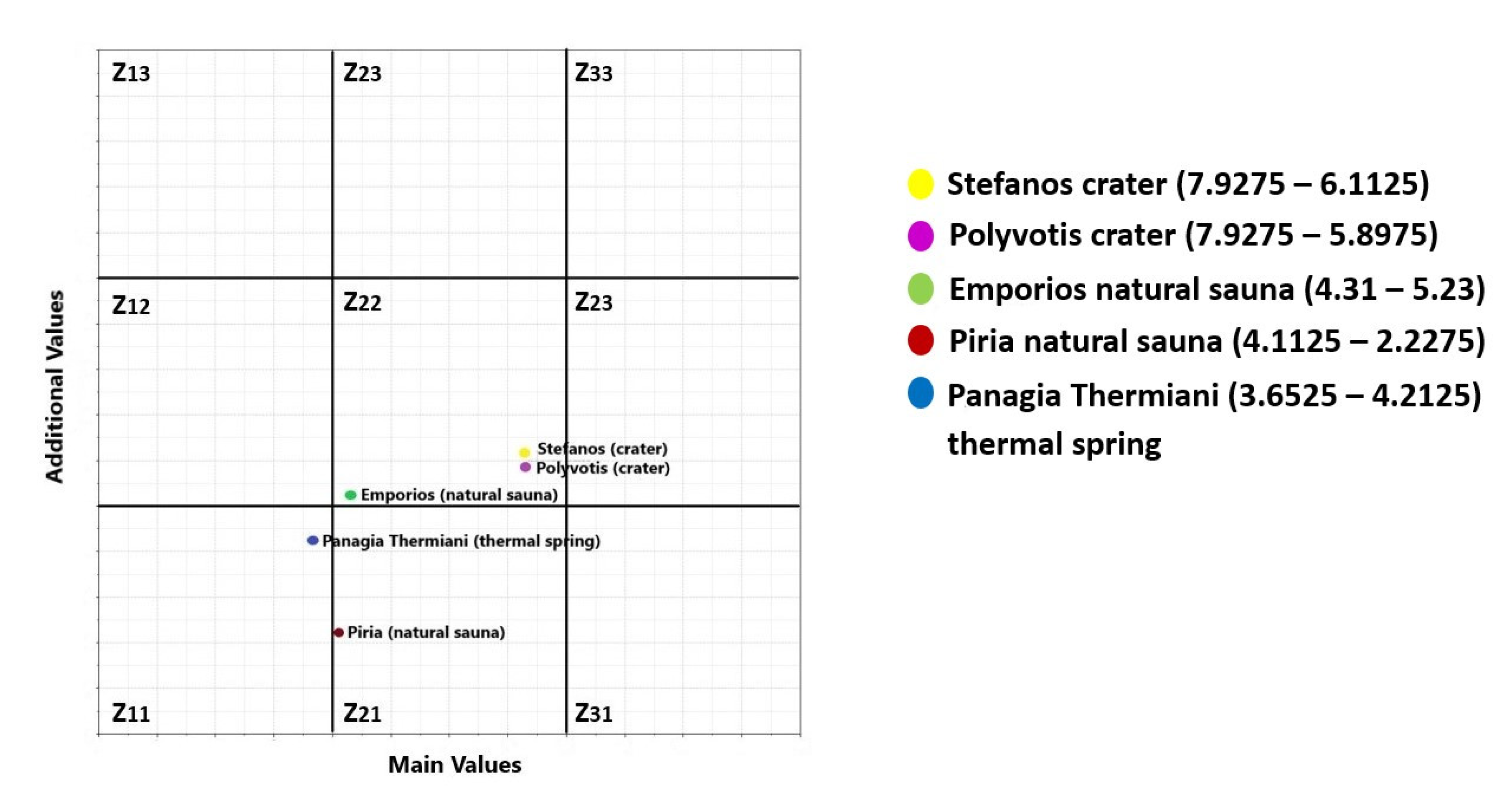
| Stefanos crater | 2.135 + 2.7625 + 2.4 | 7.2975 | 2.2575 + 3.855 | 6.1125 | Z22 |
| Polyvotis crater | 2.135 + 2.7625 + 2.4 | 7.2975 | 2.2575 + 3.64 | 5.8975 | Z22 |
| Emporios (natural sauna) | 1.2775 + 1.7175 + 1.315 | 4.31 | 2.2025 + 3.0275 | 5.23 | Z22 |
| Piria (natural sauna) | 1.2775 + 1.52 + 1.315 | 4.1125 | 0.7175 + 1.51 | 2.2275 | Z21 |
| Panagia Thermiani (thermal spring) | 0.8575 + 1.48 + 1.315 | 3.6525 | 1.905 + 2.3075 | 4.2125 | Z11 |
| Geosites | G-P Method—Final Score of Education Use | M-GAM Method—Final Score of Education Use | Conversion to a Percentage for G-P Method | Conversion to a Percentage for M-GAM Method | |
|---|---|---|---|---|---|
| Main Value | Additional Value | ||||
| GS1-Stefanos crater | 385 | 7.2975 | 6.1125 | 96.25 | 49.53 |
| GS2-Megalos Polyvotis crater | 370 | 7.2975 | 5.8975 | 92.5 | 48.85 |
| GS3-Thermal spring of Pyria | 315 | 4.31 | 5.23 | 78.75 | 35.26 |
| GS4-Thermal spring of Emporios | 285 | 4.1125 | 2.2275 | 71.25 | 24.32 |
| GS5-Thermal spring of Panagia Thermiani | 320 | 3.6525 | 4.2125 | 80.00 | 29.01 |
Publisher’s Note: MDPI stays neutral with regard to jurisdictional claims in published maps and institutional affiliations. |
© 2022 by the authors. Licensee MDPI, Basel, Switzerland. This article is an open access article distributed under the terms and conditions of the Creative Commons Attribution (CC BY) license (https://creativecommons.org/licenses/by/4.0/).
Share and Cite
Zafeiropoulos, G.; Drinia, H. Comparative Analysis of Two Assessment Methods for the Geoeducational Values of Geosites: A Case Study from the Volcanic Island of Nisyros, SE Aegean Sea, Greece. Geosciences 2022, 12, 82. https://doi.org/10.3390/geosciences12020082
Zafeiropoulos G, Drinia H. Comparative Analysis of Two Assessment Methods for the Geoeducational Values of Geosites: A Case Study from the Volcanic Island of Nisyros, SE Aegean Sea, Greece. Geosciences. 2022; 12(2):82. https://doi.org/10.3390/geosciences12020082
Chicago/Turabian StyleZafeiropoulos, George, and Hara Drinia. 2022. "Comparative Analysis of Two Assessment Methods for the Geoeducational Values of Geosites: A Case Study from the Volcanic Island of Nisyros, SE Aegean Sea, Greece" Geosciences 12, no. 2: 82. https://doi.org/10.3390/geosciences12020082
APA StyleZafeiropoulos, G., & Drinia, H. (2022). Comparative Analysis of Two Assessment Methods for the Geoeducational Values of Geosites: A Case Study from the Volcanic Island of Nisyros, SE Aegean Sea, Greece. Geosciences, 12(2), 82. https://doi.org/10.3390/geosciences12020082