Correction: King et al. Surface-Rupturing Historical Earthquakes in Australia and Their Environmental Effects: New Insights from Re-Analyses of Observational Data. Geosciences 2019, 9, 408


- 1.
- The published maximum vertical displacement (m) of the Tennant Creek 1 (Kunayungku) NT earthquake was 0.9 m, not 10.9 m;
- 2.
- The date of the Lake Muir, WA surface rupturing earthquake was 16/09/2018, not 08/11/2018 (this was the date of a Mw 5.2 aftershock, see [2] for details);
- 3.
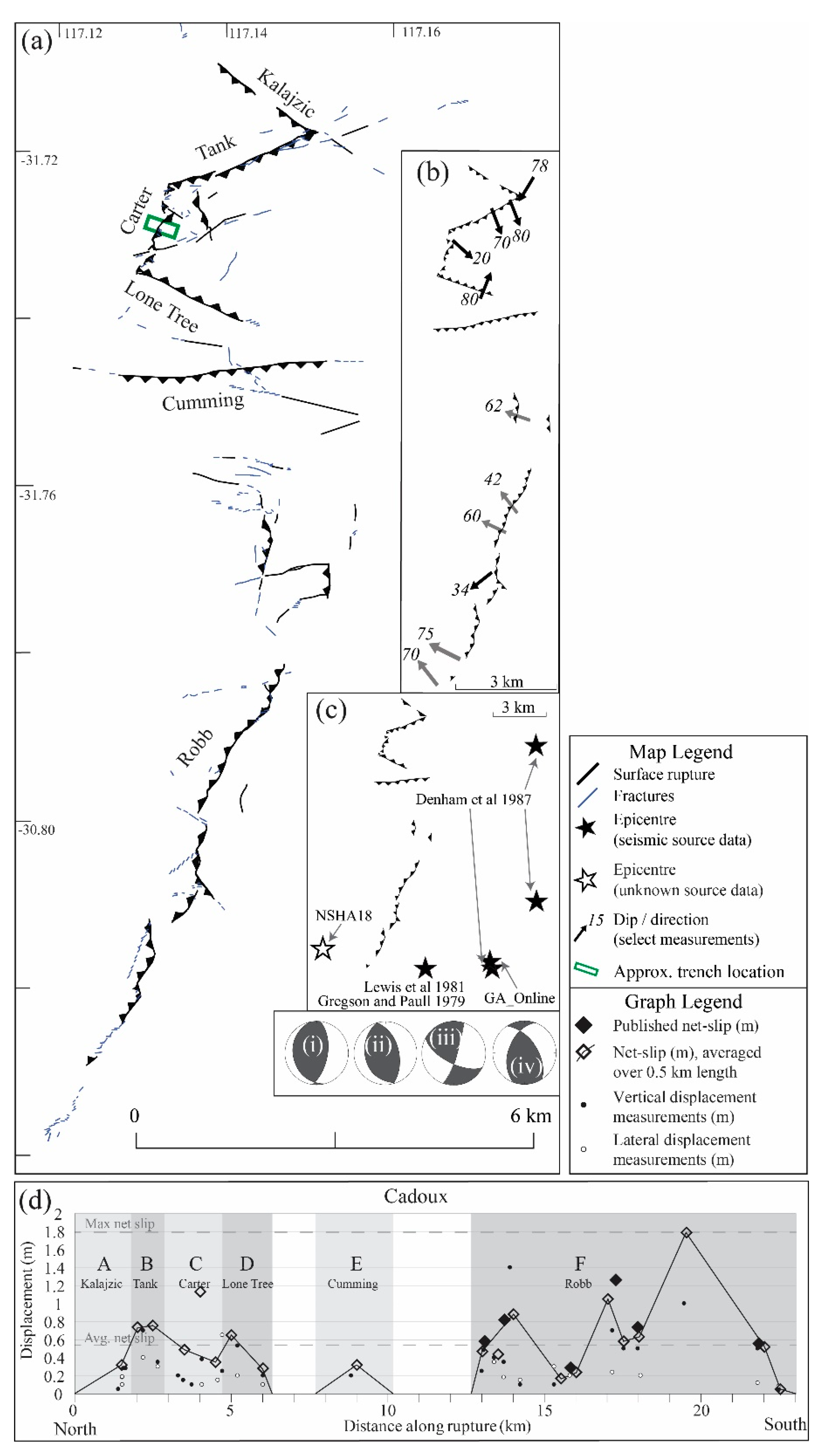
- Due to a calculation error described below, the average net-slip (m) calculated from this paper for the Cadoux earthquake should be 0.45 m, not 0.54 m.

| Name | Fig. 1 | Magnitude (Mw) [11] | Date (UTC) | This Paper: | Published | Relevant References | |||
|---|---|---|---|---|---|---|---|---|---|
| Length (km) | Dip | Avg. Net-slip (m) | Length (km) | Max. Vert. Disp. (m) | |||||
| Meckering, WA | 1 | 6.59 | 14/10/1968 | 40 ± 5 | 35° ± 10 | 1.78 | 37 | 2.5 | [12–37] |
| Calingiri, WA | 8 | 5.03 | 10/03/1970 | 3.3 ± 0.2 | 20° ± 10 | 0.46 | 3.3 | 0.4 | [23–25,38,39] |
| Cadoux, WA | 4 | 6.1 | 02/06/1979 | 20 ± 5 | 60° ± 30 | 0.45 | 14 | 1.4 | [28,40–45] |
| Marryat Creek, SA | 5 | 5.7 | 30/03/1986 | 13 ± 1 | 40° ± 10 | 0.31 | 13 | 0.9 | [1,28,46–49] |
| Tennant Creek 1 (Kunayungku) NT | 7 | 6.27 | 22/01/1988 | 9 ± 1 | 40° ± 5 | 0.55 | 10.2 | 0.9 | [1,49–69] |
| Tennant Creek 2 (Lake Surprise west) | 6 | 6.44 | 22/01/1988 | 9 ± 2 | 60° ± 10 | 0.84 | 6.7 | 1.1 | [1,49–69] |
| Tennant Creek 3 (Lake Surprise east) | 3 | 6.58 | 22/01/1988 | 16 ± 0.5 | 35 ° ± 5 | 1.23 | 16 | 1.8 | [1,49–69] |
| Katanning, WA | 10 | 4.7 | 10/10/2007 | 0.5 ± 0.5 | 40° ± 5 | 0.2 | 1.26 | 0.1 | [70,71] |
| Pukatja, SA | 9 | 5.18 | 23/03/2012 | 1.3 ± 0.3 | 30° ± 10 | 0.25 | 1.6 | 0.5 | [9,72] |
| Petermann, NT | 2 | 6.1 | 20/05/2016 | 21 ± 0.5 | 30° ± 5 | 0.42 | 20 | 1.0 | [73–78] |
| Lake Muir, WA | 5.3 | 16/09/2018 | 3 | 0.5 | [79] | ||||

| Cadoux | 117.1492 | −30.7165 | 0.06 |
| Cadoux | 117.1502 | −30.717 | 0.29 |
| Cadoux | 117.1538 | −30.7186 | 0.15 |
| Cadoux | 117.1549 | −30.7194 | 0.27 |
| Cadoux | 117.1496 | −30.7176 | 0.29 |
| Cadoux | 117.1446 | −30.7198 | 0.83 |
| Cadoux | 117.1403 | −30.722 | 0.49 |
| Cadoux | 117.1342 | −30.7233 | 0.59 |
| Cadoux | 117.1334 | −30.7237 | 0.44 |
| Cadoux | 117.1327 | −30.7262 | 0.3 |
| Cadoux | 117.1327 | −30.7279 | 1.13 |
| Cadoux | 117.1332 | −30.7312 | 0.47 |
| Cadoux | 117.1305 | −30.7329 | 0.71 |
| Cadoux | 117.1324 | −30.735 | 0.58 |
| Cadoux | 117.1395 | −30.7387 | 0.24 |
| Cadoux | 117.1373 | −30.7464 | 0.32 |
| Cadoux | 117.1392 | −30.7591 | 0 |
| Cadoux | 117.1524 | −30.7503 | 0.2 |
| Cadoux | 117.1524 | −30.7534 | 0.02 |
| Cadoux | 117.1392 | −30.7591 | 0.29 |
| Cadoux | 117.1445 | −30.7614 | 0.52 |
| Cadoux | 117.1464 | −30.7638 | 0.59 |
| Cadoux | 117.1454 | −30.7677 | 0.44 |
| Cadoux | 117.1447 | −30.7697 | 1.62 |
| Cadoux | 117.1464 | −30.7704 | 0.2 |
| Cadoux | 117.1511 | −30.773 | 0.33 |
| Cadoux | 117.1468 | −30.7756 | 0.3 |
| Cadoux | 117.144 | −30.7878 | 1.08 |
| Cadoux | 117.1415 | −30.7904 | 0.58 |
| Cadoux | 117.1398 | −30.7943 | 0.9 |
| Cadoux | 117.1423 | −30.7968 | 0.42 |
| Cadoux | 117.1372 | −30.8077 | 1.79 |
| Cadoux | 117.1279 | −30.8239 | 0.54 |
| Cadoux | 117.124 | −30.829 | 0.1 |
| Rupture | Refs. | Method 3 | Shape 4 | Published | Simplified Faults 1 | Preferred: | Displacement 2 (m) | Disp. Profile Shape 6 | ||||||||||
|---|---|---|---|---|---|---|---|---|---|---|---|---|---|---|---|---|---|---|
| Length (km) | Kin. | Dip Range | N= | Sum Length (km) | % Diff. Publ. | Length (km) | Dip | Max Vert. Disp. | Avg. Vert. Disp. 5 | % Diff. | Max Net Slip | Avg. Net Slip 5 | % Diff | |||||
| Meckering | [25] | FW; A; SB | CC | 37 | R(D) | 15–54° | 4 | 44.4 | +20% | 40 ± 5 | 35° ± 10 | 1.98 | 0.97 | 51% | 3.7 | 1.78 | 52% | S. Tg. |
| (Splinter) | [25] | 9 | R | 24–42° | 3 | 0.67 | 0.22 | 67% | 1.34 | 0.44 | 67% | AS. Tg. | ||||||
| Calingiri | [25] | FW | S | 3.3 | R(S) | 12–31° | 1 | 3.3 | 0% | 3.3 ± 0.2 | 20° ± 10 | 0.38 | 0.15 | 61% | 1.26 | 0.46 | 63% | AS. Tg. |
| Cadoux | [41] | FW; A; SB | CC/S | 14 | R | 20–80° | 6 | 20.6 | +47% | 20 ± 5 | 60° ± 30 | 1.4 | 0.35 | 75% | 1.79 | 0.45 | 75% | AS. Tg. |
| Marryat Creek | [48] | FW; A; SC | CC | 13 | R | 36–60° | 3 | 13.6 | +4% | 13 ± 1 | 40° ± 10 | 0.9 | 0.21 | 77% | 1.07 | 0.31 | 71% | Avg. |
| Kunayungku | [63] | FW; A; SC | S | 10.2 | R | 58° | 1 | 8.6 | −15% | 9 ± 1 | 40° ± 5 | 0.9 | 0.36 | 60% | 1.41 | 0.55 | 61% | S. Tg |
| Lake Surprise west | [63] | FW; A; SC | CC | 6.7 | R | 65–84° | 1 | 10.1 | +51% | 9 ± 2 | 60° ± 10 | 1.13 | 0.45 | 60% | 2.26 | 0.84 | 63% | AS. Sine |
| (LS west foot-wall) | [63] | 3.1 | R | 1 | 0.74 | 0.43 | 42% | 1.16 | 0.9 | 22% | Avg. | |||||||
| Lake Surprise east | [63] | FW; A; SC | CC | 16 | R | 28–30° | 2 | 15.3 | −4% | 16 ± 0.5 | 35 ° ± 5 | 1.8 | 0.61 | 66% | 3.6 | 1.23 | 66% | Avg |
| Katanning (visible) 7 | [70,71] | S | 0.3 | R | 1 | 0.3 | 0% | 0.5 ± 0.5 | 40° ± 5 | 0.1 | ||||||||
| Katanning (InSAR) | [70] | In. | 2.58 | 1 | 2.2 | −12% | 0.28 | 0.1 | 50% | 0.32 * | 0.2 * | 38% | AS. Tg. | |||||
| Pukatja | [9] | FW | CC | 1.6 | R | 22–28° | 1 | 1.0 | −60% | 1.3 ± 0.3 | 30° ± 10 | 0.48 | 0.12 | 75% | 0.96 | 0.25 | 74% | AS. Sine |
| Petermann (visible) | [73,77] | FW; SC; In; D; SI | CV | 20 | R | 25–36° | 3 | 21 | +5% | 21 ± 0.5 | 30° ± 5 | 0.96 | 0.2 | 1.92 | 0.42 | 78% | Avg. | |
| Petermann (InSAR) | [73] | In. | 21 | 2 | 21.5 | +2% | ||||||||||||
| Name | Rate Applied * | Mw | Pref. Length (km) | Avg. Net-Slip (m) | Maximum Slip Rate (m/Myr) | ||
|---|---|---|---|---|---|---|---|
| Min. | Max. | Mean | |||||
| Meckering | CB | 6.59 | 40 ± 5 | 1.78 | 0.2 | 3.2 | 1.7 |
| Calingiri | CB | 5.03 | 3.3 ± 0.2 | 0.46 | 0.7 | 12.4 | 6.6 |
| Cadoux | CB | 6.1 | 20 ± 5 | 0.45 | 0.7 | 12.7 | 6.7 |
| Marryat Creek | CB | 5.7 | 13 ± 1 | 0.31 | 1 | 18.4 | 9.7 |
| Kunayungku | Q | 6.27 | 9 ± 1 | 0.55 | 9.1 | 18.2 | 13.7 |
| Lake Surprise west | Q | 6.44 | 9 ± 2 | 0.84 | 6 | 11.9 | 8.9 |
| Lake Surprise east * | Q | 6.58 | 16 ± 0.5 | 1.23 | 4.1 | 8.1 | 6.1 |
| Katanning (InSAR) | CB | 4.7 | 0.5 ± 0.5 | 0.2 | 1.5 | 28.5 | 15 |
| Pukatja | CB | 5.18 | 1.3 ± 0.3 | 0.25 | 1.2 | 22.8 | 12 |
| Petermann | CB | 6.1 | 21 ± 0.5 | 0.42 | 0.7 | 13.6 | 7.2 |
| Name | Leonard 2014 [148] | Calculated [148] | This Paper | Calculated (This Paper) | Percent Difference Calculated | Avg. Net Slip 5 | % Diff 6 | Mw [11] | % Diff 6 | |||||||
|---|---|---|---|---|---|---|---|---|---|---|---|---|---|---|---|---|
| SRL 1 (km) | Source | Mw 2 | A 3 (km2) | D 4 (m) | L (km) | Mw 2 | A 3 (km2) | D 4 (m) | Mw | A (km2) | D (m) | |||||
| Meckering | 37 | [160] | 6.93 | 5546 | 5.44 | 40 | 6.99 | 6316 | 5.8 | 0.9% | 12.2% | 6.3% | 1.78 | −225.8% | 6.59 | −6.1% |
| Calingiri | 3.3 | [160] | 5.18 | 99 | 0.73 | 3.3 | 5.18 | 99 | 0.73 | 0.0% | 0.0% | 0.5% | 0.46 | −58.7% | 5.03 | −3.0% |
| Cadoux | 14 | [160] | 6.23 | 1098 | 2.42 | 20 | 6.49 | 1989 | 3.26 | 4.0% | 44.8% | 25.8% | 0.45 | −624.4% | 6.1 | −6.4% |
| Marryat Creek | 13 | [160] | 6.18 | 970 | 2.27 | 13 | 6.18 | 970 | 2.27 | 0.0% | 0.0% | −0.2% | 0.31 | −632.3% | 5.7 | −8.4% |
| Kunayungku | 10.2 | [160] | 6 | 648 | 1.86 | 9 | 5.91 | 526 | 1.67 | −1.5% | −23.2% | −11.3% | 0.55 | −203.6% | 6.27 | 5.7% |
| Lake Surprise west | 6.7 | [160] | 5.7 | 321 | 1.31 | 9 | 5.91 | 526 | 1.67 | 3.6% | 39.0% | 21.7% | 0.84 | −98.8% | 6.44 | 8.2% |
| Lake Surprise east * | 16 | [160] | 6.33 | 1372 | 2.70 | 16 | 6.33 | 1372 | 2.7 | 0.0% | 0.0% | −0.1% | 1.23 | −119.5% | 6.58 | 3.8% |
| Katanning (InSAR) | 1.26 | [70] | 4.49 | 20 | 0.33 | 0.5 | 3.82 | 4 | 0.15 | −17.5% | −400.0% | −117.6% | 0.2 | 25.0% | 4.7 | 18.7% |
| Pukatja | 1.6 | [9] | 4.66 | 30 | 0.40 | 1.3 | 4.51 | 21 | 0.33 | −3.3% | −42.9% | −21.2% | 0.25 | −32.0% | 5.18 | 12.9% |
References
- King, T.R.; Quigley, M.; Clark, D. Surface-rupturing historical earthquakes in Australia and their environmental effects: New insights from re-analyses of observational data. Geosciences 2019, 9, 408. [Google Scholar] [CrossRef] [Green Version]
- Clark, D.; Brennand, S.; Brenn, G.; Garthwaite, M.C.; Dimech, J.; Allen, T.I.; Standen, S. Surface deformation relating to the 2018 Lake Muir earthquake sequence, southwest Western Australia: New insight into stable continental region earthquakes. Solid Earth 2020, 11, 691–717. [Google Scholar] [CrossRef]
- Haibin, Y.; Quigley, M.; King, T.R. Surface slip distributions and geometric complexity of intraplate reverse-faulting earthquakes. GSA Bull. 2021, 133, 1909–1929. [Google Scholar]
Publisher’s Note: MDPI stays neutral with regard to jurisdictional claims in published maps and institutional affiliations. |
© 2022 by the authors. Licensee MDPI, Basel, Switzerland. This article is an open access article distributed under the terms and conditions of the Creative Commons Attribution (CC BY) license (https://creativecommons.org/licenses/by/4.0/).
Share and Cite
King, T.R.; Quigley, M.; Clark, D. Correction: King et al. Surface-Rupturing Historical Earthquakes in Australia and Their Environmental Effects: New Insights from Re-Analyses of Observational Data. Geosciences 2019, 9, 408. Geosciences 2022, 12, 81. https://doi.org/10.3390/geosciences12020081
King TR, Quigley M, Clark D. Correction: King et al. Surface-Rupturing Historical Earthquakes in Australia and Their Environmental Effects: New Insights from Re-Analyses of Observational Data. Geosciences 2019, 9, 408. Geosciences. 2022; 12(2):81. https://doi.org/10.3390/geosciences12020081
Chicago/Turabian StyleKing, Tamarah R., Mark Quigley, and Dan Clark. 2022. "Correction: King et al. Surface-Rupturing Historical Earthquakes in Australia and Their Environmental Effects: New Insights from Re-Analyses of Observational Data. Geosciences 2019, 9, 408" Geosciences 12, no. 2: 81. https://doi.org/10.3390/geosciences12020081
APA StyleKing, T. R., Quigley, M., & Clark, D. (2022). Correction: King et al. Surface-Rupturing Historical Earthquakes in Australia and Their Environmental Effects: New Insights from Re-Analyses of Observational Data. Geosciences 2019, 9, 408. Geosciences, 12(2), 81. https://doi.org/10.3390/geosciences12020081