
Slope Failure in a Period of Increased Landslide Activity: Sennwald Rock Avalanche, Switzerland

 , and
, and
Abstract
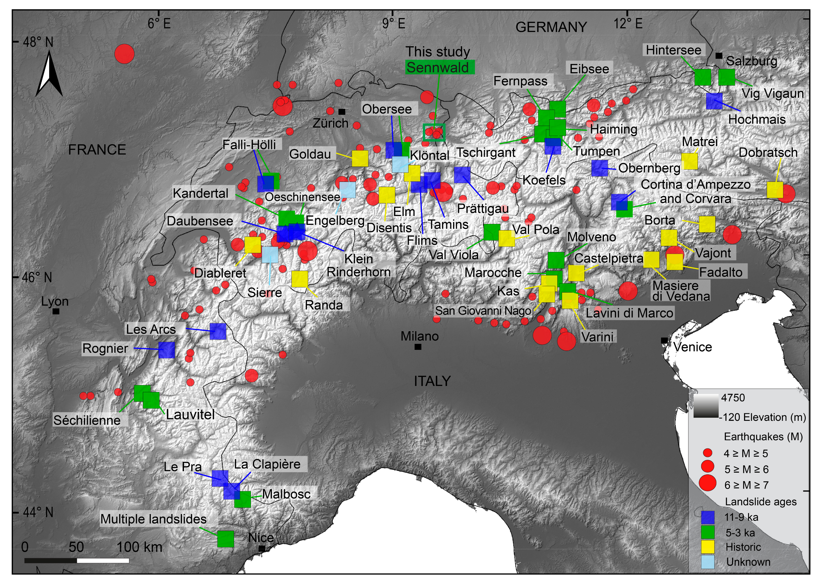
:1. Introduction
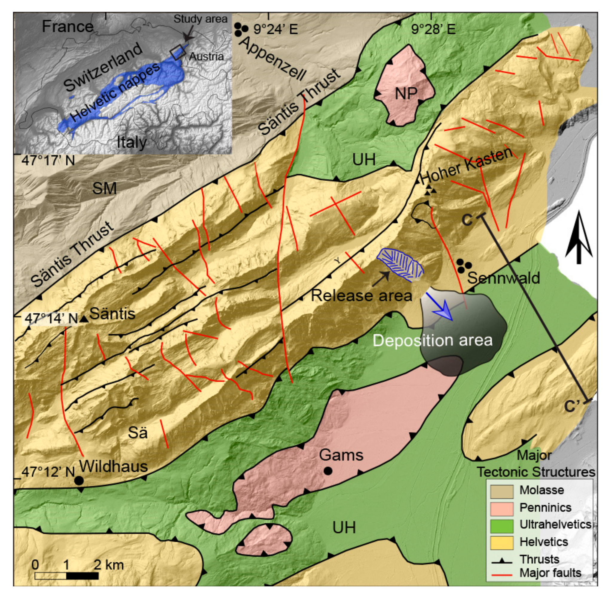
Tectonic Setting and Geology
- Vitznau Marl (Valanginian) [29] consists of mainly marly limestones and is a fossiliferous and clay-rich unit at the base.
- Betliskalk (formerly Valanginienkalk) [29] is mostly bio-pelsparites and biomicrites with fine grain, brownish to greyish and weathered sand with chert nodules. The weathering colour is grey. Betliskalk is stratigraphically on top of Öhrlikalk and Vitznau-Mergel.
- Helvetischer Kieselkalk (Valanginian-Hauterivian) [30,31] consists of siliceous limestone from dark grey to bluish grey colour and is known to be rich in glauconite and pyrite. It shows a mixture of calcareous particles, calcified sponge spicules and detrital quartz in a matrix of micritic to microsparitic calcite.
- Drusberg Formation (Barremian) consists of dark blue-grey calcareous shales regularly alternating with thin-bedded light-brownish limestones. Drusberg layers represent autochthonous fauna that consists of sponge spicules, echinoderm fragments and some radiolarians [32]. Oysters and other bivalves, ammonites and nautilids are also noted [33].
- Schrattenkalk (Early Barremian-Early Aptian) [34] is a grey to light grey marine limestone with bioclastic wackestone-packstone, and well-sorted grainstones. Coral, rudist, Nerinea, brachiopod, Porifera, Orbitolinid, echinoid, bivalve and brachiopod are noted in Schrattenkalk [33]. In some parts, detrital quartz and sometimes brecciated lithoclasts are seen in this formation.
- Helvetischer Gault (Late Aptian-Middle Cenomanian), Reference [29], also known as Garschella Formation, consists of greenish to greyish glauconitic sandstones, marls and nodular and sparitic carbonates. Ammonoids, bivalve, belemnite, nautilids, brachiopods and planktonic foraminifera are identified.
2. The Sennwald Landslide
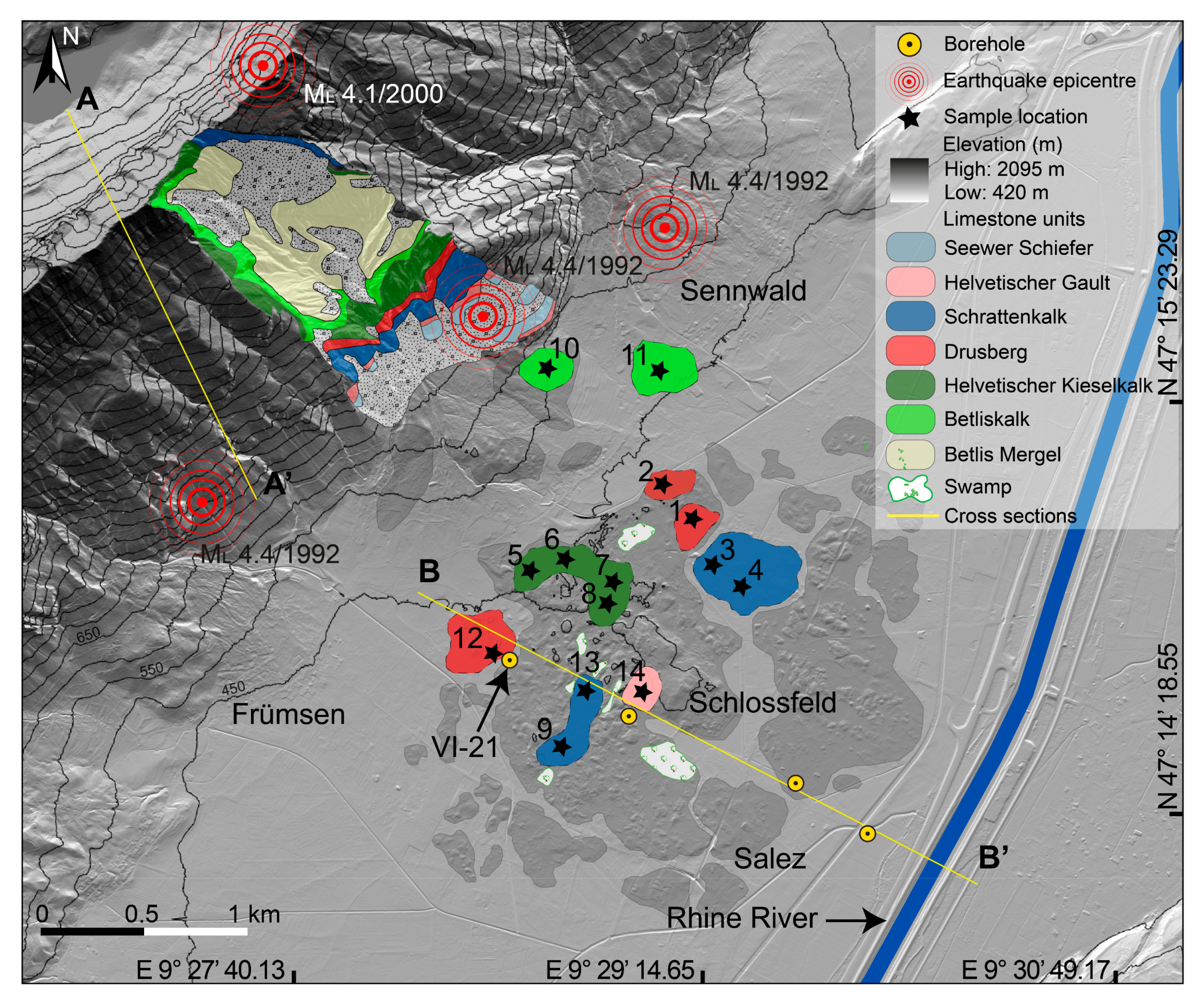
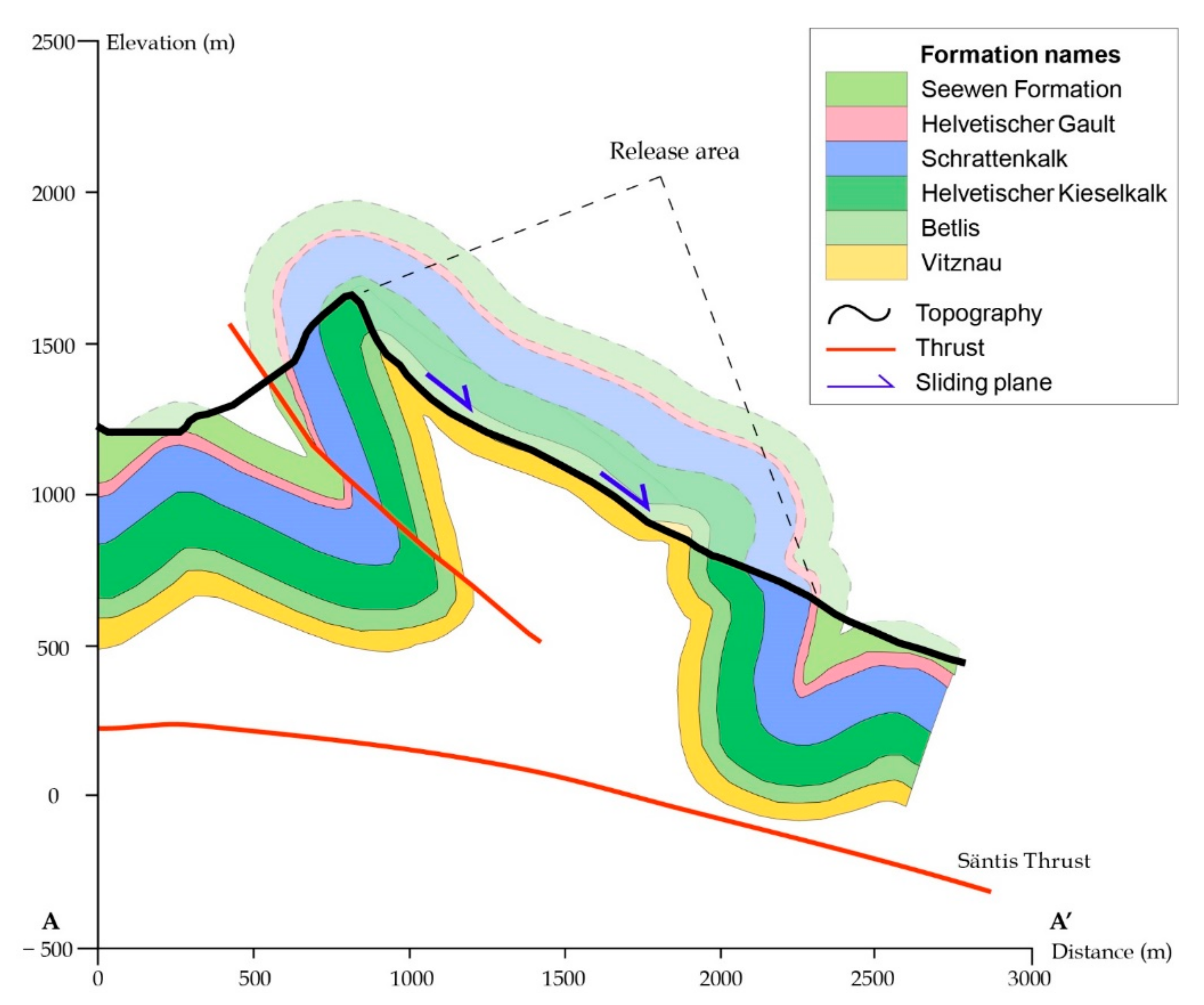
2.1. The Release and Deposition Areas
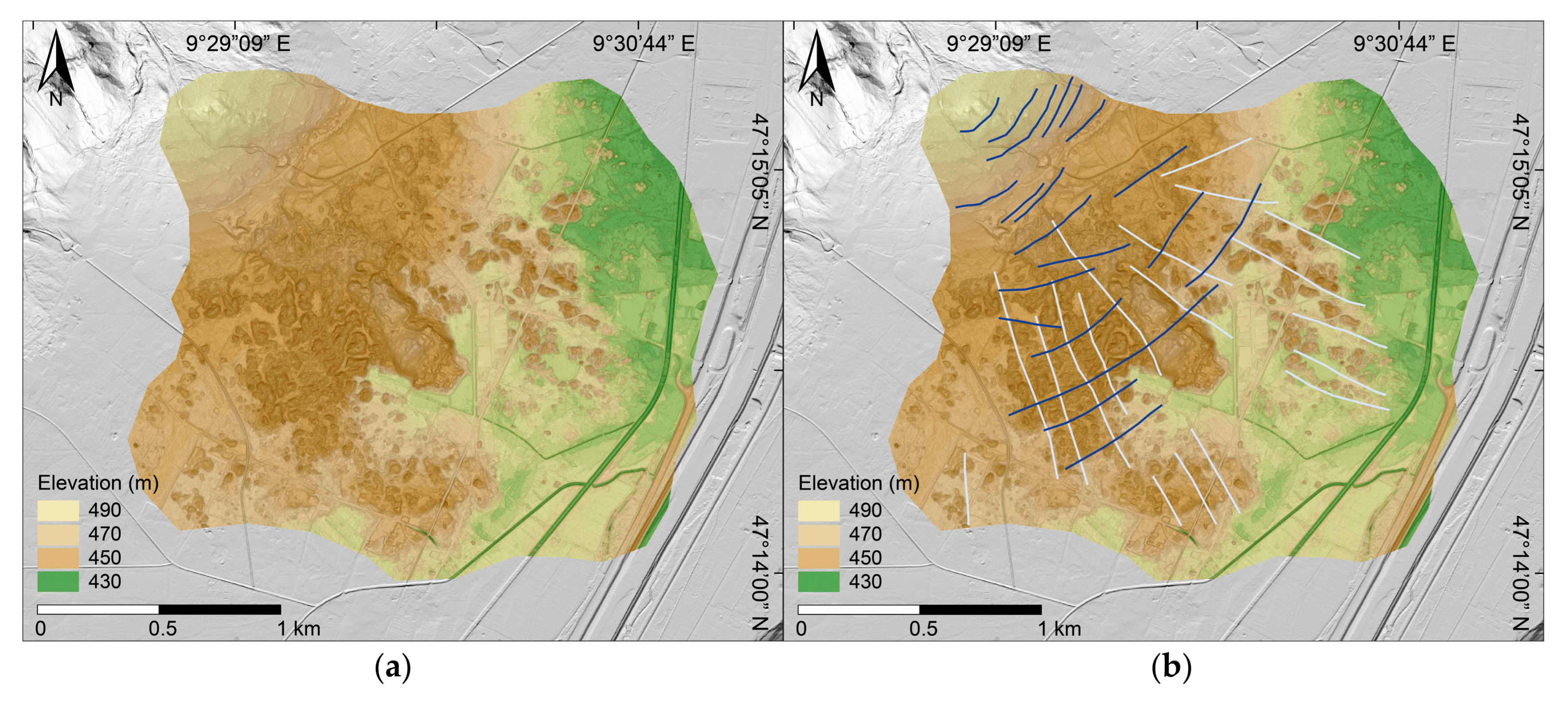
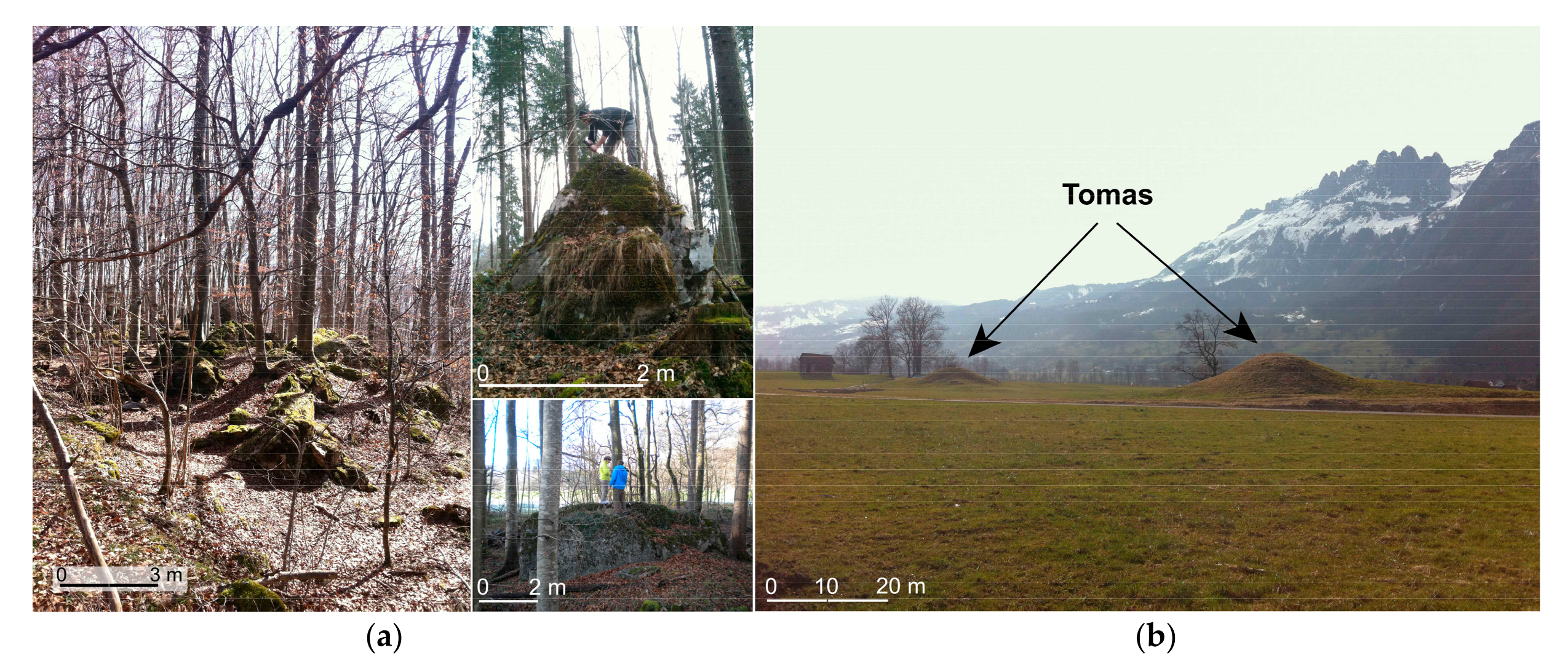
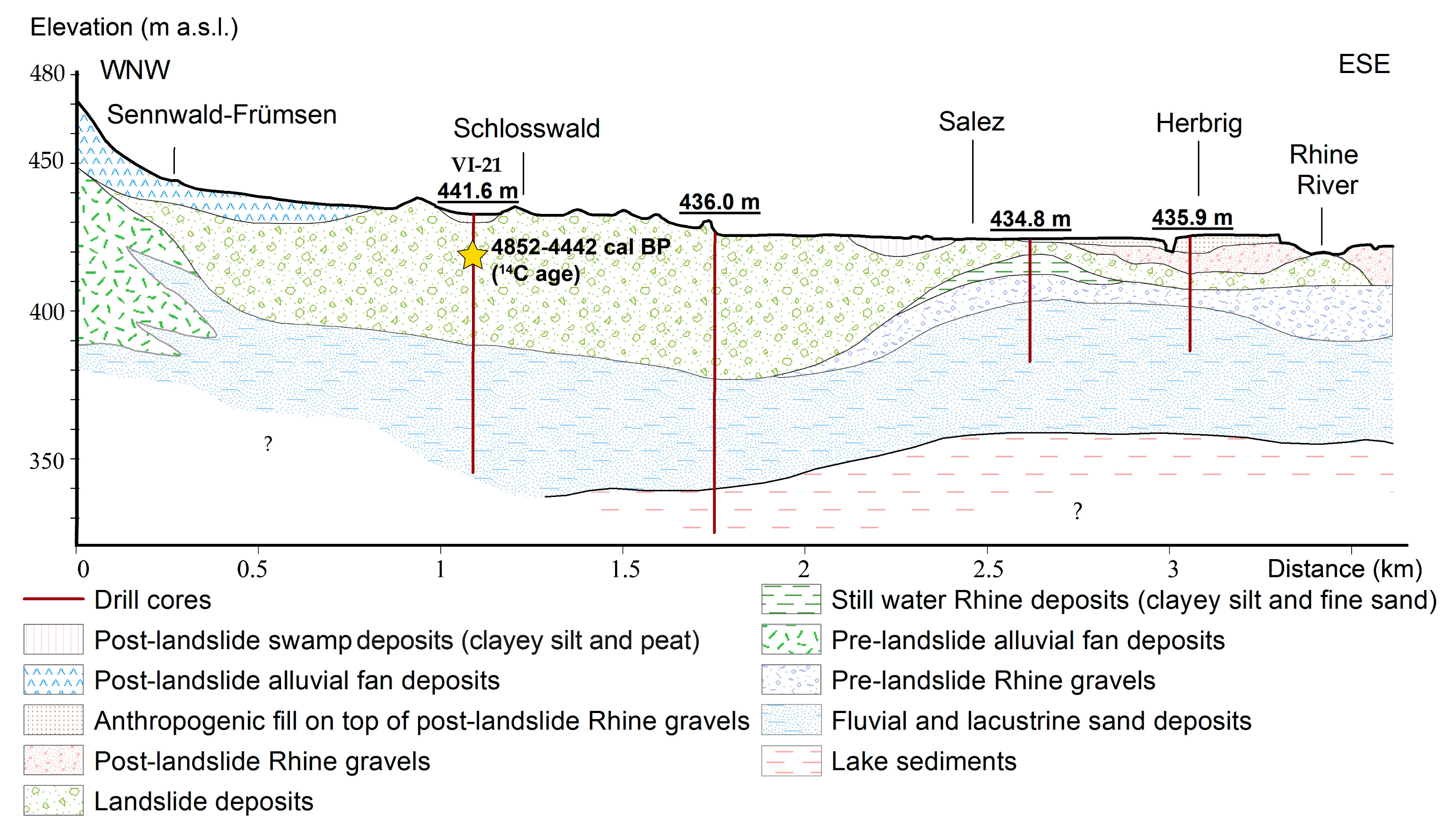
2.2. Distribution of the Landslide Material in the Deposition Area
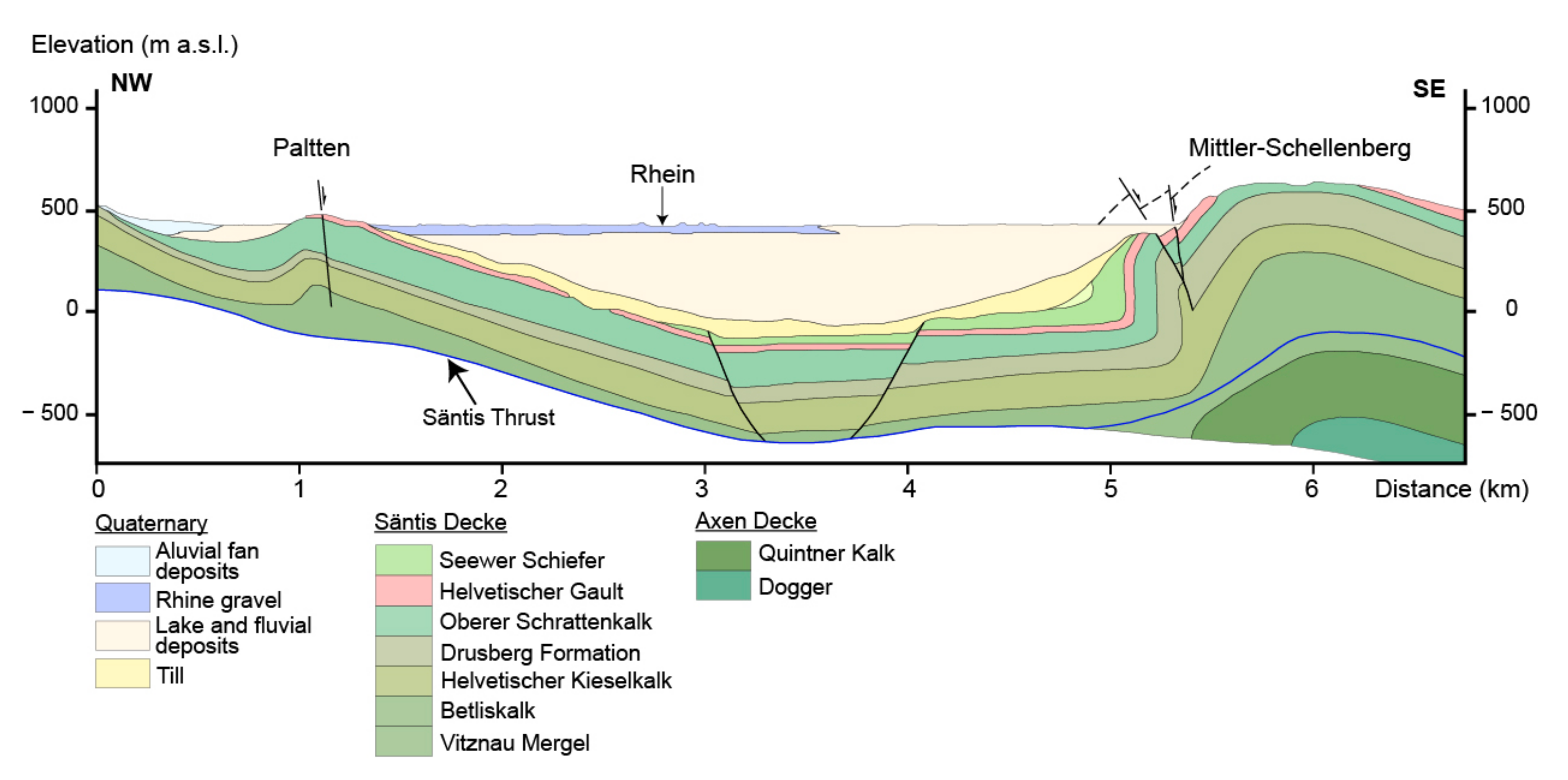
2.3. Cross Profiles for the Release and Deposition Areas
3. Surface Exposure Dating Using Cosmogenic 36Cl
4. Dynamic Run-Out Modelling
4.1. Pre-Failure Topography and Volume Estimation
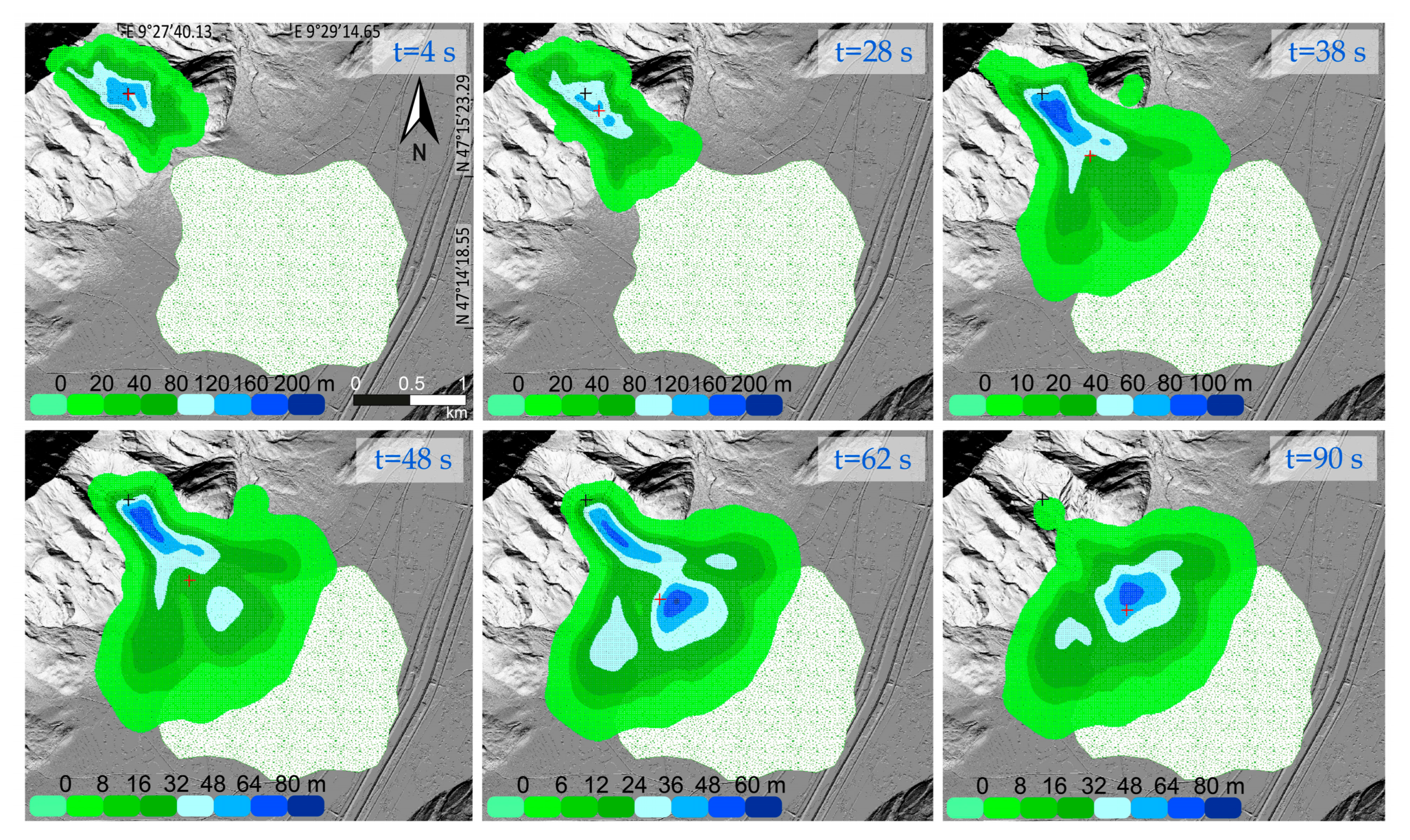
4.2. Run-Out Simulation
5. Discussion: Potential Triggers
6. Conclusions
Author Contributions
Funding
Institutional Review Board Statement
Informed Consent Statement
Data Availability Statement
Acknowledgments
Conflicts of Interest
Appendix A

| Sample | SW-1 | SW-2 | SW-4 | SW-9 | SW-10 | SW-12 | SW-13 | SW-14 |
|---|---|---|---|---|---|---|---|---|
| SiO2 | 1.32419 | 11.614 | 0.69853 | 0.86071 | 0.8894 | 0.71356 | 1.1239 | 1.36607 |
| TiO2 | 0.00909 | 0.02581 | 0.01176 | 0.00905 | 0.00905 | 0.00846 | 0.0085 | 0.0161 |
| Al2O3 | 0.09483 | 0.58497 | 0.09747 | 0.09896 | 0.09505 | 0.10379 | 0.08502 | 0.24805 |
| Fe2O3 | 0.75522 | 0.35147 | 0.10195 | 0.1295 | 0.14201 | 0.16358 | 0.13262 | 0.1437 |
| MnO | 0.01249 | 0.00983 | 0.0028 | 0.00509 | 0.00679 | 0.00395 | 0.00397 | 0.00477 |
| MgO | 0.26518 | 0.46577 | 0.29073 | 0.55647 | 0.47695 | 0.38245 | 0.47098 | 0.4973 |
| CaO | 54.896 | 48.0414 | 55.3741 | 55.383 | 55.4178 | 55.5288 | 55.3443 | 57.7568 |
| Na2O | 0.09767 | 0.02458 | 0.01008 | 0.02092 | 0.03621 | 0.01072 | 0.05214 | 0.01491 |
| K2O | 0.02385 | 0.14624 | 0.01568 | 0.02036 | 0.02207 | 0.01861 | 0.02154 | 0.05188 |
| P2O5 | 0.00738 | 0.02581 | 0.01008 | 0.01357 | 0.01075 | 0.01015 | 0.017 | 0.00716 |
| Cr2O3 | 0 | 0 | 0 | 0 | 0 | 0 | 0 | 0.00012 |
| NiO | 0.00137 | 0.00127 | 0.00113 | 0.00096 | 0.0011 | 0.00133 | 0.00125 | 0.00122 |
| LOI | 43.7522 | 38.4559 | 44.4527 | 43.8691 | 43.8288 | 44.0069 | 43.77 | 40.6972 |
| Total | 101.239 | 99.7471 | 101.067 | 100.968 | 100.936 | 100.952 | 101.031 | 100.805 |
| B | 0.00000 | 0.00000 | 0.00000 | 0.00000 | 0.00030 | 0.00030 | 0.00030 | 0.00030 |
| Sm | 0.00000 | 0.00000 | 0.00000 | 0.00000 | 0.00006 | 0.00006 | 0.00004 | 0.00004 |
| Gd | 0.00000 | 0.00000 | 0.00000 | 0.00000 | 0.00006 | 0.00006 | 0.00005 | 0.00005 |
| U | 0.00000 | 0.00000 | 0.00000 | 0.00000 | 0.00040 | 0.00040 | 0.00050 | 0.00050 |
| Th | 0.003210 | 0.003310 | 0.003940 | 0.003490 | 0.000020 | 0.000020 | 0.000050 | 0.000050 |
References
- Stark, C.P.; Hovius, N. The characterization of landslide size distributions. Geophys. Res. Lett. 2001, 28, 1091–1094. [Google Scholar] [CrossRef]
- Meunier, P.; Hovius, N.; Haines, J.A. Topographic site effects and the location of earthquake induced landslides. Earth Planet. Sci. Lett. 2008, 275, 221–232. [Google Scholar] [CrossRef]
- Korup, O. Earth’s portfolio of extreme sediment transport events. Earth-Sci. Rev. 2012, 112, 115–125. [Google Scholar] [CrossRef]
- Davies, T. Landslide Hazards, Risks, and Disasters: Introduction; Elsevier Inc.: Amsterdam, The Netherlands, 2015; ISBN 9780123964755. [Google Scholar]
- Malamud, B.D.; Turcotte, D.L.; Guzzetti, F.; Reichenbach, P. Landslide inventories and their statistical properties. Earth Surf. Process. Landf. 2004, 29, 687–711. [Google Scholar] [CrossRef]
- Keefer, D.K. Investigating landslides caused by earthquakes—A historical review. Surv. Geophys. 2002, 23, 473–510. [Google Scholar] [CrossRef]
- Zerathe, S.; Lebourg, T.; Braucher, R.; Bourlès, D. Mid-Holocene cluster of large-scale landslides revealed in the Southwestern Alps by 36Cl dating. Insight on an Alpine-scale landslide activity. Quat. Sci. Rev. 2014, 90, 106–127. [Google Scholar] [CrossRef]
- Corsini, A.; Marchetti, M.; Soldati, M. Dinamica olocenica dei versanti nell’area di Corvara in Badia (Dolomiti, Italia): Cronologia e significato paleoclimatico di alcuni fenomeni franosi. Geogr. Fis. E Din. Quat. 2001, 24, 127–139. [Google Scholar]
- Prager, C.; Zangerl, C.; Brandner, R.; Patzelt, G. Increased rockslide activity in the middle Holocene? New evidence from the Tyrolean Alps (Austria). In Landslides and Climate Change: Challenges and Solutions; Taylor & Francis: Oxford, UK, 2007; pp. 25–34. [Google Scholar]
- Borgatti, L.; Soldati, M. Landslides as a geomorphological proxy for climate change: A record from the Dolomites (northern Italy). Geomorphology 2010, 120, 56–64. [Google Scholar] [CrossRef]
- Pánek, T. Recent progress in landslide dating: A global overview. Prog. Phys. Geogr. 2014, 39, 168–198. [Google Scholar] [CrossRef]
- Ivy-Ochs, S.; Martin, S.; Campedel, P.; Hippe, K.; Alfimov, V.; Vockenhuber, C.; Andreotti, E.; Carugati, G.; Pasqual, D.; Rigo, M.; et al. Geomorphology and age of the Marocche di Dro rock avalanches (Trentino, Italy). Quat. Sci. Rev. 2017, 169, 188–205. [Google Scholar] [CrossRef]
- Oswald, P.; Strasser, M.; Hammerl, C.; Moernaut, J. Seismic control of large prehistoric rockslides in the Eastern Alps. Nat. Commun. 2021, 12. [Google Scholar] [CrossRef]
- Ivy-Ochs, S.; Heuberger, H.; Kubik, P.; Kerschner, H.; Bonani, G.; Frank, M.; Schlüchter, C. The age of the Köfels event. Relative, 14C and cosmogenic isotope dating of an early Holocene landslide in the Central Alps (Tyrol, Austria). Z. Für Gletsch. Und Glazialgeol. 1998, 34, 57–68. [Google Scholar]
- Kubik, P.W.; Ivy-Ochs, S.; Masarik, J.; Frank, M.; Schlüchter, C. 10Be and 26Al production rates deduced from an instantaneous event within the dendro-calibration curve, the landslide of Köfels, Ötz Valley, Austria. Earth Planet. Sci. Lett. 1998, 161, 231–241. [Google Scholar] [CrossRef]
- Ivy-Ochs, S.; Poschinger, A.V.; Synal, H.A.; Maisch, M. Surface exposure dating of the Flims landslide, Graubünden, Switzerland. Geomorphology 2009, 103, 104–112. [Google Scholar] [CrossRef]
- Prager, C.; Ivy-Ochs, S.; Ostermann, M.; Synal, H.-A.; Patzelt, G. Geology and radiometric 14C-, 36Cl- and Th-/U-dating of the Fernpass rockslide (Tyrol, Austria). Geomorphology 2009, 103, 93–103. [Google Scholar] [CrossRef]
- Moore, J.R.; Sanders, J.W.; Dietrich, W.E.; Glaser, S.D. Influence of rock mass strength on the erosion rate of alpine cliffs. Earth Surf. Process. Landf. 2009, 34, 1339–1352. [Google Scholar] [CrossRef]
- Stead, D.; Wolter, A. A critical review of rock slope failure mechanisms: The importance of structural geology. J. Struct. Geol. 2015, 74, 1–23. [Google Scholar] [CrossRef]
- Ambrosi, C.; Crosta, G.B. Valley shape influence on deformation mechanisms of rock slopes. Geol. Soc. Spec. Publ. 2011, 351, 215–233. [Google Scholar] [CrossRef]
- Sweeting, M.M. Karst Landforms; Columbia University Press: New York, NY, USA, 1973. [Google Scholar]
- Prager, C.; Zangerl, C.; Nagler, T. Geological controls on slope deformations in the Köfels rockslide area (Tyrol, Austria). Austrian J. Earth Sci. 2009, 102, 4–19. [Google Scholar]
- Densmore, A.L.; Hovius, N. Topographic fingerprints of bedrock landslides. Geology 2000, 28, 371–374. [Google Scholar] [CrossRef]
- Pfiffner, O.A. The Helvetic nappe system and landscape evolution of the Kander. Bull. Fuer Angew. Geol. 2010, 15, 53–61. [Google Scholar]
- Pfiffner, A.O. Geology of the Alps, 2nd ed.; John Wiley & Sons: Sussex, UK, 2014; ISBN 978-1-118-70812-5. [Google Scholar]
- Pfiffner, A. Fold-and-thrust tectonics in the Helvetic Nappes (E Switzerland). Thrust Nappe Tectonics. Geol. Soc. Lond. 1981, 319–327. [Google Scholar] [CrossRef]
- Pfiffner, O.A. The structure of the Helvetic nappes and its relation to the mechanical stratigraphy. J. Struct. Geol. 1993, 15, 511–521. [Google Scholar] [CrossRef]
- Sala, P.; Pfiffner, O.A.; Frehner, M. The Alpstein in three dimensions: Fold-and-thrust belt visualization in the Helvetic zone, eastern Switzerland. Swiss J. Geosci. 2014, 107, 177–195. [Google Scholar] [CrossRef]
- Burger, H.; Strasser, A. Lithostratigraphische Einheiten der untersten Helvetischen Kreide in der Zentral- und Ostschweiz. Eclogae Geol. Helv. 1981, 74, 529–560. [Google Scholar]
- Funk, H. Typusprofile der helvetischen Kieselkalk-Formation und der Altmann-Schichten. Eclogae Geol. Helv. 1969, 62, 191–203. [Google Scholar]
- Funk, H. The origin of authigenic quartz in the Helvetic Siliceous Limestone (Helvetischer Kieselkalk), Switzerland. Sedimentology 1975, 22, 299–306. [Google Scholar] [CrossRef]
- Staeger, D. Geologie der Wilerhorngruppe zwischen Brienz und Lungern. Eclogae Geol. Helv. 1944, 37/1, 99–188. [Google Scholar]
- Kursteiner, P. Field Guide to the excursions. In Proceedings of the 9th International Symposium, Cephalopods-Present and Past; Christian Klug, W.E., Ed.; Paläontologisches Institut und Museum, Universität Zürich: Zurich, Switzerland, 2014. [Google Scholar]
- Ziegler, M.A. A Study of the Lower Cretaceous Facies Developements in the Helvetic Border Chain, North of the Lake of Thun (Switzerland). Eclogae Geol. Helv. 1967, 60, 509–527. [Google Scholar]
- Eugster, H.; Forrer, M.; Frohlicher, H.; Kempf, T.; Schlatter, L.; Blaser, R.; Funk, H.; Langenegger, H.; Spoerri, M.; Habicht, K. Säntis (map sheet 1115) Geological Atlas of Switzerland 1:25.000; Federal Office of Topography (Swisstopo): Bern, Switzerland, 1982.
- Funk, H.; Habicht, K.J.; Hantke, R.; Pfiffner, A.O. Blatt 1115 Säntis—Geologischer Atlas der Schweiz 1:25’000, Erläuterungen 78; Bundesamt für Wasser und Geologie: Bern, Switzerland, 2000. [Google Scholar]
- Gutiérrez-Santolalla, F.; Acosta, E.; Ríos, S.; Guerrero, J.; Lucha, P. Geomorphology and geochronology of sackung features (uphill-facing scarps) in the Central Spanish Pyrenees. Geomorphology 2005, 69, 298–314. [Google Scholar] [CrossRef]
- Cossart, E.; Braucher, R.; Fort, M.; Bourlès, D.L.; Carcaillet, J. Slope instability in relation to glacial debuttressing in alpine areas (Upper Durance catchment, southeastern France): Evidence from field data and 10Be cosmic ray exposure ages. Geomorphology 2008, 95, 3–26. [Google Scholar] [CrossRef]
- Audemard, F.A.; Beck, C.; Carrillo, E. Deep-seated gravitational slope deformations along the active Boconó Fault in the central portion of the Mérida Andes, western Venezuela. Geomorphology 2010, 124, 164–177. [Google Scholar] [CrossRef]
- Pánek, T.; Tábořík, P.; Klimeš, J.; Komárková, V.; Hradeckỳ, J.; Št’astnỳ, M. Deep-seated gravitational slope deformations in the highest parts of the Czech Flysch Carpathians: Evolutionary model based on kinematic analysis, electrical imaging and trenching. Geomorphology 2011, 129, 92–112. [Google Scholar] [CrossRef]
- Furrer, G.; Fitze, P. Beitrag zum Permafrostproblem in den Alpen. Vierteljahresschr. Der Nat. Ges. Zürich 1970, 115, 353–368. [Google Scholar]
- Reitner, J.M. Bericht 2000 über geologische Aufnahmen im Quartär auf Blatt 179 Lienz. Jahrb. Der Geol. Bundesanst. 2003, 143, 389–395. [Google Scholar]
- Von Poschinger, A. Weitere Erkenntnisse und Weitere Fragen zum Flimser Bergsturz. Bull. Fuer Angew. Geol. 2006, 11, 35–43. [Google Scholar]
- Dufresne, A.; Davies, T.R. Longitudinal ridges in mass movement deposits. Geomorphology 2009, 105, 171–181. [Google Scholar] [CrossRef]
- Strom, A. Morphology and internal structure of rockslides and rock avalanches: Grounds and constraints for their modelling. In Landslides from Massive Rock Slope Failure; Springer Netherlands: Dordrecht, The Netherlands, 2006; Volume 49, pp. 305–326. ISBN 978-1-4020-4035-1. [Google Scholar]
- Kobel, M.; Hantke, R. Zur Hydrogeologie des Rheintales von Sargans bis zum Bodensee (Exkursion E am 19. April 1979). Jahresber. Und Mitt. Des Oberrh. Geol. Ver. 1979, 79–86. [Google Scholar] [CrossRef]
- García-García, F.; Sánchez-Gómez, M.; Navarro, V.; Pla, S. Formation, infill, and dissection of a latest-Pleistocene landslide-dammed reservoir (Betic Cordillera, Southern Spain): Upstream and downstream geomorphological and sedimentological evidence. Quat. Int. 2011, 233, 61–71. [Google Scholar] [CrossRef]
- Korup, O.; Wang, G. Multiple Landslide-Damming Episodes. In Landslide Hazards, Risks and Disasters; Shroder, J.F., Davies, T., Eds.; Elsevier: Amsterdam, The Netherlands, 2015; pp. 241–261. ISBN 9780123964755. [Google Scholar]
- Preusser, F.; Reitner, J.M.; Schlüchter, C. Distribution, geometry, age and origin of overdeepened valleys and basins in the Alps and their foreland. Swiss J. Geosci. 2010, 103, 407–426. [Google Scholar] [CrossRef] [Green Version]
- Dehnert, A.; Lowick, S.E.; Preusser, F.; Anselmetti, F.S.; Drescher-Schneider, R.; Graf, H.R.; Heller, F.; Horstmeyer, H.; Kemna, H.A.; Nowaczyk, N.R.; et al. Evolution of an overdeepened trough in the northern Alpine Foreland at Niederweningen, Switzerland. Quat. Sci. Rev. 2012, 34, 127–145. [Google Scholar] [CrossRef]
- Dürst Stucki, M.; Schlunegger, F. Identification of erosional mechanisms during past glaciations based on a bedrock surface model of the central European Alps. Earth Planet. Sci. Lett. 2013, 384, 57–70. [Google Scholar] [CrossRef]
- Pfiffner, A.; Frei, W.; Finckh, P.; Valasek, P. Deep seismic reflection profiling in the Swiss Alps: Explosion seismology results for line NFP 20-East. Geology 1988, 16, 987. [Google Scholar] [CrossRef]
- Valasek, P.; Mueller, S.; Frei, W.; Holliger, K. Results of NFP 20 seismic reflection profiling along the Alpine section of the European Geotraverse (EGT). Geophys. J. Int. 1991, 105, 85–102. [Google Scholar] [CrossRef] [Green Version]
- Ivy-Ochs, S.; Kober, F. Surface exposure dating with cosmogenic nuclides. Quat. Sci. J. (Eiszeitalt. Und Ggw.) 2008, 57, 179–209. [Google Scholar] [CrossRef] [Green Version]
- Ivy-Ochs, S.; Synal, H.A.; Roth, C.; Schaller, M. Initial results from isotope dilution for Cl and 36Cl measurements at the PSI/ETH Zurich AMS facility. Nucl. Instrum. Methods Phys. Res. Sect. B Beam Interact. Mater. At. 2004, 223–224, 623–627. [Google Scholar] [CrossRef]
- Christl, M.; Vockenhuber, C.; Kubik, P.W.; Wacker, L.; Lachner, J.; Alfimov, V.; Synal, H.-A. The ETH Zurich AMS facilities: Performance parameters and reference materials. Nucl. Instrum. Methods Phys. Res. Sect. B Beam Interact. Mater. At. 2013, 294, 29–38. [Google Scholar] [CrossRef]
- Synal, H.-A.; Bonani, G.; Döbeli, M.; Ender, R.M.; Gartenmann, P.; Kubik, P.W.; Schnabel, C.; Suter, M. Status report of the PSI/ETH AMS facility. Nucl. Instrum. Methods Phys. Res. Sect. B Beam Interact. Mater. At. 1997, 123, 62–68. [Google Scholar] [CrossRef]
- Martin, S.; Campedel, P.; Ivy-Ochs, S.; Viganò, A.; Alfimov, V.; Vockenhuber, C.; Andreotti, E.; Carugati, G.; Pasqual, D.; Rigo, M. Lavini di Marco (Trentino, Italy): 36Cl exposure dating of a polyphase rock avalanche. Quat. Geochronol. 2014, 19, 106–116. [Google Scholar] [CrossRef]
- Alfimov, V.; Ivy-Ochs, S. How well do we understand production of 36Cl in limestone and dolomite? Quat. Geochronol. 2009, 4, 462–474. [Google Scholar] [CrossRef]
- Stone, J.O.; Allan, G.L.; Fifield, L.K.; Cresswell, R.G. Cosmogenic chlorine-36 from calcium spallation. Geochim. Et Cosmochim. Acta 1996, 60, 679–692. [Google Scholar] [CrossRef]
- Stone, J.O.; Evans, J.M.; Fifield, L.K.; Allan, G.L.; Cresswell, R.G. Cosmogenic Chlorine-36 Production in Calcite by Muons. Geochim. Et Cosmochim. Acta 1998, 62, 433–454. [Google Scholar] [CrossRef]
- Ivy-Ochs, S.; Kerschner, H.; Reuther, A.; Maisch, M.; Sailer, R.; Schaefer, J.; Kubik, P.W.; Synal, H.-A.; Schlüchter, C. The timing of glacier advances in the northern European Alps based on surface exposure dating with cosmogenic 10Be, 26Al, 36Cl, and 21Ne. Geol. Soc. Am. Spec. Pap. 2006, 415, 43–60. [Google Scholar]
- Häuselmann, P.; Lauritzen, S.-E.; Jeannin, P.-Y.; Monbaron, M. Glacier advances during the last 400 ka as evidenced in St. Beatus Caves (BE, Switzerland). Quat. Int. 2008, 189, 173–189. [Google Scholar] [CrossRef] [Green Version]
- Ivy-Ochs, S.; Schaller, M. Chapter 6 Examining Processes and Rates of Landscape Change with Cosmogenic Radionuclides. Radioact. Environ. 2009, 16, 231–294. [Google Scholar] [CrossRef]
- Zwahlen, P.; Radiocarbondatierung. Dr. M. Kobel + Partner AG, Büro für Technische Geologie AG, Sargans, Switzerland. Personal communication, 1980.
- Reimer, P.J.; Austin, W.E.N.; Bard, E.; Bayliss, A.; Blackwell, P.G.; Bronk Ramsey, C.; Butzin, M.; Cheng, H.; Edwards, R.L.; Friedrich, M.; et al. The IntCal20 Northern Hemisphere Radiocarbon Age Calibration Curve (0-55 cal kBP). Radiocarbon 2020, 62, 725–757. [Google Scholar] [CrossRef]
- Ramsey, C.B. Bayesian Analysis of Radiocarbon Dates. Radiocarbon 2009, 51, 337–360. [Google Scholar] [CrossRef] [Green Version]
- Hungr, O.; Evans, S.G. Entrainment of debris in rock avalanches: An analysis of a long run-out mechanism. Bull. Geol. Soc. Am. 2004, 116, 1240–1252. [Google Scholar] [CrossRef]
- Pirulli, M. The Thurwieser rock avalanche (Italian Alps): Description and dynamic analysis. Eng. Geol. 2009, 109, 80–92. [Google Scholar] [CrossRef]
- Grämiger, L.M.; Moore, J.R.; Vockenhuber, C.; Aaron, J.; Hajdas, I.; Ivy-Ochs, S. Two early Holocene rock avalanches in the Bernese Alps (Rinderhorn, Switzerland). Geomorphology 2016, 268, 207–221. [Google Scholar] [CrossRef]
- Hungr, O. A model for the runout analysis of rapid flow slides, debris flows, and avalanches. Can. Geotech. J. 1995, 32, 610–623. [Google Scholar] [CrossRef]
- Evans, S.G.; Hungr, O.; Enegren, E.G. The Avalanche Lake rock avalanche, Mackenzie Mountains, Northwest Territories, Canada: Description, dating, and dynamics. Can. Geotech. J. 1994, 31, 749–768. [Google Scholar] [CrossRef]
- Hungr, O.; Evans, S. Rock avalanche runout prediction using a dynamic model. Landslides 1996, 21. [Google Scholar]
- Hungr, O.; Evans, S. A dynamic model for landslides with changing mass. Eng. Geol. Environ. 1997, 41, 719–722. [Google Scholar]
- Davies, T.R.; McSaveney, M.J. Runout of dry granular avalanches. Can. Geotech. J. 1999, 36, 313–320. [Google Scholar] [CrossRef]
- Nagelisen, J.; Moore, J.R.; Vockenhuber, C.; Ivy-Ochs, S. Post-glacial rock avalanches in the Obersee Valley, Glarner Alps, Switzerland. Geomorphology 2015, 238, 94–111. [Google Scholar] [CrossRef]
- Sosio, R.; Crosta, G.B.; Hungr, O. Numerical modeling of debris avalanche propagation from collapse of volcanic edifices. Landslides 2012, 9, 315–334. [Google Scholar] [CrossRef]
- Evans, S.G.; Hungr, O.; Clague, J.J. Dynamics of the 1984 rock avalanche and associated distal debris flow on Mount Cayley, British Columbia, Canada; Implications for landslide hazard assessment on dissected volcanoes. Eng. Geol. 2001, 61, 29–51. [Google Scholar] [CrossRef]
- Ivy-Ochs, S. Glacier variations in the European Alps at the end of the last glaciation. Cuad. De Investig. Geográfica 2015, 41, 295. [Google Scholar] [CrossRef] [Green Version]
- Walker, M.J.C.; Berkelhammer, M.; Björck, S.; Cwynar, L.C.; Fisher, D.A.; Long, A.J.; Lowe, J.J.; Newnham, R.M.; Rasmussen, S.O.; Weiss, H. Formal subdivision of the Holocene Series/Epoch: A Discussion Paper by a Working Group of INTIMATE (Integration of ice-core, marine and terrestrial records) and the Subcommission on Quaternary Stratigraphy (International Commission on Stratigraphy). J. Quat. Sci. 2012, 27, 649–659. [Google Scholar] [CrossRef]
- Fäh, D.; Giardini, D.; Kästli, P.; Deichmann, N.; Gisler, M.; Schwarz-Zanetti, G.; Alvarez-Rubio, S.; Sellami, S.; Edwards, B.; Allmann, B.; et al. ECOS-09 Earthquake Catalogue of Switzerland Release 2011. Report and Database -Events from AD 250. Public Catalogue. Swiss Seismological Service ETH Zürich. 2011. Available online: http://ecos09.seismo.ethz.ch/query_sum (accessed on 15 July 2015).
- USGS ComCat Earthquake Hazards Program. The ANSS Comprehensive Earthquake Catalog (ComCat). Available online: http://earthquake.usgs.gov/earthquakes/search/ (accessed on 20 May 2021).
- Dapples, F.; Oswald, D.; Raetzo, H.; Lardelli, T.; Zwahlen, P. New records of Holocene landslide activity in the Western and Eastern Swiss Alps: Implication of climate and vegetation changes. Ecol. Geol. Helv. 2003, 96, 1–9. [Google Scholar] [CrossRef]
- Bigot-Cormier, F.; Braucher, R.; Bourlès, D.; Guglielmi, Y.; Dubar, M.; Stéphan, J.-F. Chronological constraints on processes leading to large active landslides. Earth Planet. Sci. Lett. 2005, 235, 141–150. [Google Scholar] [CrossRef]
- El Bedoui, S.; Bois, T.; Jomard, H.; Sanchez, G.; Lebourg, T.; Trics, E.; Guglielmi, Y.; Bouissou, S.; Chemenda, A.; Rolland, Y.; et al. Paraglacial gravitational deformations in the SW Alps: A review of field investigations, 10 Be cosmogenic dating and physical modelling. Geol. Soc. Lond. Spec. Publ. 2011, 351, 11–25. [Google Scholar] [CrossRef]
- Nicolussi, K.; Spötl, C.; Thurner, A.; Reimer, P.J. Precise radiocarbon dating of the giant Köfels landslide (Eastern Alps, Austria). Geomorphology 2015, 243, 87–91. [Google Scholar] [CrossRef]
- von Poschinger, A.; Haas, U. Der Bergsturz von Flims, doch ein warmzeitliches Ereignis. Bull. Für Angew. Geol. 1997, 2, 35–46. [Google Scholar]
- Prager, C.; Zangerl, C.; Patzelt, G.; Brandner, R. Age distribution of fossil landslides in the Tyrol (Austria) and its surrounding areas. Nat. Hazards Earth Syst. Sci. 2008, 8, 377–407. [Google Scholar] [CrossRef]
- Hippolyte, J.-C.; Brocard, G.; Tardy, M.; Nicoud, G.; Bourlès, D.; Braucher, R.; Ménard, G.; Souffaché, B. The recent fault scarps of the Western Alps (France): Tectonic surface ruptures or gravitational sackung scarps? A combined mapping, geomorphic, levelling, and 10Be dating approach. Tectonophysics 2006, 418, 255–276. [Google Scholar] [CrossRef]
- Ostermann, M.; Sanders, D.; Ivy-Ochs, S.; Alfimov, V.; Rockenschaub, M.; Römer, A. Early Holocene (8.6ka) rock avalanche deposits, Obernberg valley (Eastern Alps): Landform interpretation and kinematics of rapid mass movement. Geomorphology 2012, 171–172, 83–93. [Google Scholar] [CrossRef] [Green Version]
- Martin, S.; Ivy-Ochs, S.; Viganò, A.; Campedel, P.; Rigo, M.; Vockenhuber, C.; Gabrieli, F.; Mair, V.; Rossato, S. LANDSLIDES OF THE WESTERN DOLOMITES: CASE STUDIES FROM THE ADIGE AND SARCA VALLEYS (NE ITALY). Alp. Mediterr. Quat. 2020, 33, 191–207. [Google Scholar] [CrossRef]
- Le Roux, O.; Schwartz, S.; Gamond, J.F.; Jongmans, D.; Bourles, D.; Braucher, R.; Mahaney, W.; Carcaillet, J.; Leanni, L. CRE dating on the head scarp of a major landslide (Séchilienne, French Alps), age constraints on Holocene kinematics. Earth Planet. Sci. Lett. 2009, 280, 236–245. [Google Scholar] [CrossRef]
- Delunel, R.; Hantz, D.; Braucher, R.; Bourlès, D.L.; Schoeneich, P.; Deparis, J. Surface exposure dating and geophysical prospecting of the Holocene Lauvitel rock slide (French Alps). Landslides 2010, 7, 393–400. [Google Scholar] [CrossRef]
- Jerz, H.; von Poschinger, A. Neuere Ergebnisse zum Bergsturz Eibsee-Grainau. Geol. Bavarica 1995, 99, 383–398. [Google Scholar]
- von Poschinger, A.; Thom, P. Bergsturz Hintersee/Ramsau (Berchtesgadener land): Neue Untersuchungsergebnisse. Quartär Südbayern 1995, 99, 399. [Google Scholar]
- Singeisen, C.; Ivy-Ochs, S.; Wolter, A.; Steinemann, O.; Akçar, N.; Yesilyurt, S.; Vockenhuber, C. The Kandersteg rock avalanche (Switzerland): Integrated analysis of a late Holocene catastrophic event. Landslides 2020, 17, 1297–1317. [Google Scholar] [CrossRef]
- Ostermann, M.; Ivy-Ochs, S.; Sanders, D.; Prager, C. Multi-method ( 14 C, 36 Cl, 234 U/ 230 Th) age bracketing of the Tschirgant rock avalanche (Eastern Alps): Implications for absolute dating of catastrophic mass-wasting. Earth Surf. Process. Landf. 2017, 42, 1110–1118. [Google Scholar] [CrossRef]
- von Wartburg, J.; Ivy-Ochs, S.; Aaron, J.; Martin, S.; Leith, K.; Rigo, M.; Vockenhuber, C.; Campedel, P.; Viganò, A. Constraining the Age and Source Area of the Molveno landslide Deposits in the Brenta Group, Trentino Dolomites (Italy). Front. Earth Sci. 2020, 8, 164. [Google Scholar] [CrossRef]
- Köpfli, P.; Grämiger, L.M.; Moore, J.R.; Vockenhuber, C.; Ivy-Ochs, S. The Oeschinensee rock avalanche, Bernese Alps, Switzerland: A co-seismic failure 2300 years ago? Swiss J. Geosci. 2018, 111, 205–219. [Google Scholar] [CrossRef]
- Abele, G. Bergstürze in den Alpen: Ihre Verbreitung. In Morphologie und Folgeerscheinungen, Wissenschaftliche Alpenvereinshefte 25; Deutscher Alpenverein: München, Germany, 1974. [Google Scholar]
- Orombelli, G.; Sauro, U. I Lavini di Marco: Un gruppo di frane oloceniche nel contesto morfoneotettonico dell’alta Val Lagarina (Trentino). Suppl. Di Geogr. Fis. E Din. Quat. 1988, 1, 107–116. [Google Scholar]
- Brandt, A. Die Bergstürze an der Villacher Alpe (Dobratsch), Kärnten/ Östereich: Untersuchungen zur Ursache und Mechanik der Bergstürze. Ph.D. Thesis, University of Hamburg, Hamburg, Germany, 1981. [Google Scholar]
- Bonnard, C. Technical and Human Aspects of Historic Rockslide-Dammed Lakes and Landslide Dam Breaches. Springer: Berlin/Heidelberg, Germany, 2011; pp. 101–122. [Google Scholar]
- Sanchez, G.; Rolland, Y.; Corsini, M.; Braucher, R.; Bourlès, D.; Arnold, M.; Aumaître, G. Relationships between tectonics, slope instability and climate change: Cosmic ray exposure dating of active faults, landslides and glacial surfaces in the SW Alps. Geomorphology 2010, 117, 1–13. [Google Scholar] [CrossRef]
- Hippolyte, J.-C.; Bourlès, D.; Braucher, R.; Carcaillet, J.; Léanni, L.; Arnold, M.; Aumaitre, G. Cosmogenic 10Be dating of a sackung and its faulted rock glaciers, in the Alps of Savoy (France). Geomorphology 2009, 108, 312–320. [Google Scholar] [CrossRef]
- Soldati, M.; Corsini, A.; Pasuto, A. Landslides and climate change in the Italian Dolomites since the Late glacial. In Proceedings of the Catena; Elsevier: Amsterdam, The Netherlands, 2004; Volume 55, pp. 141–161. [Google Scholar]
- Simonneau, A.; Chapron, E.; Vannière, B.; Wirth, S.B.; Gilli, A.; Di Giovanni, C.; Anselmetti, F.S.; Desmet, M.; Magny, M. Multidisciplinary distinction of mass-movement and flood-induced deposits in lacustrine environments: Implications for Holocene palaeohydrology and natural hazards (Lake Ledro, Southern Alps, Italy). Clim. Past Discuss. 2012, 8, 3205–3249. [Google Scholar] [CrossRef]
- Magny, M.; Combourieu-Nebout, N.; De Beaulieu, J.L.; Bout-Roumazeilles, V.; Colombaroli, D.; Desprat, S.; Francke, A.; Joannin, S.; Ortu, E.; Peyron, O.; et al. North-south palaeohydrological contrasts in the central mediterranean during the holocene: Tentative synthesis and working hypotheses. Clim. Past 2013, 9, 2043–2071. [Google Scholar] [CrossRef] [Green Version]
- Strasser, M.; Anselmetti, F.S.; Fäh, D.; Giardini, D.; Schnellmann, M. Magnitudes and source areas of large prehistoric norhern Alpine earthquakes revealed by slope failures in lakes. Geology 2006, 34, 1005–1008. [Google Scholar] [CrossRef]
- Strasser, M.; Monecke, K.; Schnellmann, M.; Anselmetti, F.S. Lake sediments as natural seismographs: A compiled record of Late Quaternary earthquakes in Central Switzerland and its implication for Alpine deformation. Sedimentology 2013, 60, 319–341. [Google Scholar] [CrossRef]
- Calais, E.; Nocquet, J.M.; Jouanne, F.; Tardy, M. Current strain regime in the Western Alps from continuous Global Positioning System measurements, 1996-2001. Geology 2002, 30, 651–654. [Google Scholar] [CrossRef]
- Froitzheim, N.; Plasienka, D.; Schuster, R. Alpine tectonics of the Alps and Western Carpathians. Geol. Cent. Eur. 2008, 2, 1141–1232. [Google Scholar]
- Brune, J.N. Shattered Rock and Precarious Rock Evidence for Strong Asymmetry in Ground Motions during Thrust Faulting. Bull. Seismol. Soc. Am. 2001, 91, 441–447. [Google Scholar] [CrossRef]
- Stoffel, M.; Huggel, C. Effects of climate change on mass movements in mountain environments. Prog. Phys. Geogr. 2012, 36, 421–439. [Google Scholar] [CrossRef]
- Deline, P.; Akçar, N.; Ivy-Ochs, S.; Kubik, P.W. Repeated Holocene rock avalanches onto the Brenva Glacier, Mont Blanc massif, Italy: A chronology. Quat. Sci. Rev. 2015, 126, 186–200. [Google Scholar] [CrossRef]


| Sample Code | Elevation (m) | Latitude | Longitude | Shielding | 36Cl 106 Atoms/g Rock | Cl in Rock (ppm) | Exposure Ages (Years) |
|---|---|---|---|---|---|---|---|
| SW-1 | 443 | 47.2516 | 9.4985 | 0.992 | 0.112 ± 0.015 | 4.5 ± 0.1 | 3850 ± 520 |
| SW-2 | 446 | 47.2530 | 9.4970 | 0.991 | 0.065 ± 0.005 | 19.6 ± 0.2 | 2340 ± 120 |
| SW-4 | 439 | 47.2484 | 9.5017 | 0.985 | 0.151 ± 0.008 | 9.7 ± 0.2 | 5030 ± 310 |
| SW-9 | 445 | 47.2415 | 9.4900 | 0.990 | 0.197 ± 0.012 | 13.6 ± 0.3 | 6480 ± 440 |
| SW-10 | 503 | 47.2582 | 9.4910 | 0.980 | 0.140 ± 0.007 | 13.1 ± 0.2 | 4360 ± 260 |
| SW-12 | 446 | 47.2458 | 9.4858 | 0.990 | 0.114 ± 0.006 | 11.5 ± 0.2 | 3770 ± 220 |
| SW-13 | 442 | 47.2442 | 9.4917 | 0.990 | 0.130 ± 0.007 | 16.0 ± 0.2 | 4210 ± 260 |
| SW-14 | 443 | 47.2439 | 9.4952 | 0.990 | 0.142 ± 0.007 | 15.5 ± 0.2 | 4440 ± 250 |
| Parameter | Value |
|---|---|
| Release volume | 92 × 106 (m3) |
| Deposition area | 6 (km2) |
| Unit weight for limestone | 24.0 (kN/m3) |
| Internal friction angle | 35 (°) |
| Coefficient of friction | 0.25 |
| Mean velocity | 50 (m/s) |
| Max-min thickness | 60–20 (m) |
| Plan travel distance | 1611 (m) |
| Total emplacement time | 150 (s) |
Publisher’s Note: MDPI stays neutral with regard to jurisdictional claims in published maps and institutional affiliations. |
© 2021 by the authors. Licensee MDPI, Basel, Switzerland. This article is an open access article distributed under the terms and conditions of the Creative Commons Attribution (CC BY) license (https://creativecommons.org/licenses/by/4.0/).
Share and Cite
Aksay, S.; Ivy-Ochs, S.; Hippe, K.; Grämiger, L.; Vockenhuber, C. Slope Failure in a Period of Increased Landslide Activity: Sennwald Rock Avalanche, Switzerland. Geosciences 2021, 11, 331. https://doi.org/10.3390/geosciences11080331
Aksay S, Ivy-Ochs S, Hippe K, Grämiger L, Vockenhuber C. Slope Failure in a Period of Increased Landslide Activity: Sennwald Rock Avalanche, Switzerland. Geosciences. 2021; 11(8):331. https://doi.org/10.3390/geosciences11080331
Chicago/Turabian StyleAksay, Selçuk, Susan Ivy-Ochs, Kristina Hippe, Lorenz Grämiger, and Christof Vockenhuber. 2021. "Slope Failure in a Period of Increased Landslide Activity: Sennwald Rock Avalanche, Switzerland" Geosciences 11, no. 8: 331. https://doi.org/10.3390/geosciences11080331
APA StyleAksay, S., Ivy-Ochs, S., Hippe, K., Grämiger, L., & Vockenhuber, C. (2021). Slope Failure in a Period of Increased Landslide Activity: Sennwald Rock Avalanche, Switzerland. Geosciences, 11(8), 331. https://doi.org/10.3390/geosciences11080331