Abstract
Amid the accelerating agenda of Chinese-style modernization, China’s territorial spatial planning is undergoing a major transition and facing mounting challenges, while the theoretical foundations that support this transition remain at an early stage and require further integration. Drawing on holism, this paper operationalizes a cognition–relation–testing governance chain and develops an analytical framework to explain the institutional evolution and governance performance of China’s territorial spatial planning. Using clause- and paragraph-level evidence units from policy and planning texts, the study reviews and compares five historical stages of China’s territorial spatial planning, emphasizing simultaneous consistency across the three levels and a replicable diagnostic procedure. Building on this analysis, the paper proposes a holistic coordination pathway oriented toward modernization governance: it anchors implementation in auditable trade-off rules and executable boundary instruments, strengthens collaboration and conflict-adjudication procedures, and embeds a closed loop of “evaluation–adjustment–accountability” across the full planning life cycle, thereby providing an analytical approach and indicator toolkit for assessing the degree of governance closure in planning practice.
1. Introduction
For a long time, China’s territorial spatial planning practice has been constrained by the recurring coexistence of multiple plans, goal conflicts across administrative levels and sectoral departments, and a persistent disconnect between plan-making and implementation. These problems have impeded the high-quality advancement of Chinese modernization. After nearly six years of institutional integration and practical experimentation, territorial spatial planning has preliminarily established an integrated system of multi-plan integration and a planning architecture characterized by “five levels and three categories,” consolidating the institutional foundations of multi-plan integration and promoting a shift in planning practice from fragmented pluralism toward overall integration [1].
However, a review of planning scholarship and the institutional arrangements for plan preparation suggests a persistent mismatch: the development of China’s urban planning theory has not been fully aligned with the practical needs of territorial spatial planning. Transitional pressures therefore persist, including legacy conflicts from multi-plan coexistence, inconsistencies in the transmission of authority and responsibilities, and insufficient implementation feedback [2]. In response, it is necessary to clarify the governance-oriented meaning and boundaries of “territorial spatial planning” and, on this basis, adopt a more explanatory framework to address the new contradictions and tasks that continue to emerge during the reform process [3].
Territorial spatial planning, as a policy instrument, is used to allocate land, resources, and space in a rational manner, and establishing a territorial spatial planning system constitutes a systemic, holistic, and reconstructive reform. A unified territorial spatial planning system embodies the national will and provides an institutional foundation for promoting high-quality development, building a better quality of life, improving governance capacity, and advancing ecological civilization [1]. However, in practice, organic linkages among urban–rural planning, land-use planning, and various sectoral plans have long been weak. The coexistence of multiple objectives, multiple levels, and multiple actors raises coordination costs and blurs responsibility boundaries, making it difficult to break the recurrent cycle of “planning conflict–implementation failure–piecemeal repair” [4]. At this stage, it is necessary to seize the ongoing reform of territorial spatial planning as a window of transformation, and to clarify the connotations and system logic of territorial spatial planning from a holistic perspective, thereby proposing pathways for planning transformation under Chinese-style modernization.
Against this backdrop, this study focuses on how, under the broader agenda of Chinese modernization, the planning conflicts and implementation disjunctions produced by multi-plan coexistence can be interpreted in terms of their evolutionary logic and translated into guidance for governance transformation. To address this question, we further examine how planning conflicts emerge and evolve across different development stages, what mechanisms underpin these dynamics through the three-level process, cognition–relation–testing, and how to formulate governance responses that are commensurate with these mechanisms.
Although the empirical focus is China’s territorial spatial planning reform, we seek to reveal mechanism-based challenges of broader relevance in spatial governance: multi-objective tensions between development and protection, overlaps in authority and responsibilities across levels, and implementation feedback deficits arising from multi-actor interactions. In the absence of a verifiable institutional closed loop, these contradictions can accumulate into the erosion of ecological baselines, declining efficiency of public investment, the diffusion of cross-jurisdictional externalities, and damage to planning legitimacy.
2. Research Design and Methods
This study aims to explain the historical evolutionary logic of China’s territorial spatial planning reform under the broader agenda of Chinese modernization and, on this basis, identify the key governance bottlenecks confronting the reform and propose operational governance pathways. We employ a framework-guided qualitative institutional–policy text analysis to conduct a structured cross-stage comparison.
2.1. Research Design and Research Questions
Rather than merely describing the evolution of China’s territorial spatial planning reform, this study focuses on how planning governance can integrate institutions, coordinate authority and responsibilities, and build a closed-loop implementation mechanism under multiple objectives, administrative levels, and sectoral departments, while identifying the major contradictions and conflicts that emerge in the process and the governance measures needed to address them. Accordingly, we operationalize holism as a governance chain, the three-level governance chain: cognition–relation–testing, and use it to trace cross-stage changes in goal articulation, the organization of authority and responsibilities, and testing and feedback mechanisms. This design allows us to identify and assess the logical linkages and consistency requirements across the sequence of “institutional evolution–governance bottlenecks–governance responses.”
When multi-objective tensions, cross-level authority–responsibility inconsistencies, and feedback deficits occur, the three-level process of cognition–relation–testing functions as a diagnostic tool for locating governance failures and identifying gaps in the institutional closed loop.
2.2. Data Sources and Scope of Materials
We compile two complementary corpora: a national-level policy-text corpus and an academic-literature corpus. The policy-text corpus focuses on national-level laws, regulations, and major institutional documents; local materials are used only to supplement the implementation characteristics and local responses of particular stages.
(1) Policy-text corpus
The policy-text corpus includes (i) national-level laws/regulations and institutional reform documents relevant to planning governance (e.g., CPC Central Committee/State Council and planning-system reform documents) and (ii) statutory plans at the national, provincial, and municipal levels (master, special, and implementation plans). Documents are included when they shape the planning-system architecture, authority–responsibility allocation, land-use control, or evaluation/accountability, and when their clause-level provisions can be coded against the indicators in Table 1 (e.g., use-control rules, monitoring–feedback, and accountability mechanisms). The full inventory of policy and institutional documents is provided in Appendix A.1 (Table A1).

Table 1.
Operational indicators for the three-level process: cognition–relation–testing.
(2) Academic literature corpus
The academic literature serves two purposes. First, it supports the theoretical positioning and conceptual specification of holism and enables comparisons with related frameworks such as systems theory and complex adaptive systems, thereby clarifying the rationale for the methodological choice adopted in this study. Second, it is used to cross-check the mechanism-based inferences derived from the policy-text analysis, strengthening the internal consistency of interpretation.
2.3. Operationalization of the Analytical Framework and Coding Scheme
We operationalize holism as a three-level governance chain (cognition–relation–testing) and define indicators for each level (Table 1). The cognitive level examines whether policy texts institutionalize (i) goal articulation, (ii) value orientations, and (iii) baseline boundaries, together with explicit trade-off rules. The relational level assesses whether the allocation of authority and responsibilities across central–local hierarchies, departments, and actors is translated into organizational arrangements, including coordination mechanisms and linkage procedures. The testing level evaluates whether land-use control, constraint mechanisms, monitoring and evaluation, feedback adjustment, and accountability incentives constitute an auditable institutional closed loop for correction and recalibration (Table 1).
To ensure reproducibility, we adopt framework-guided qualitative coding. Clauses and paragraphs from policy and planning documents are treated as the coding units. We first label each unit by its institutional function to identify the evidence type, and then map it to the corresponding indicators in Table 1 to conduct within-stage synthesis and cross-stage comparison. For provisions that simultaneously cover multiple levels, the primary code is assigned according to the dominant institutional function, while cross-cutting elements are recorded as secondary tags in the coding log. This strategy avoids double counting while preserving information on coupling across governance elements. The full codebook and coding decision rules are provided in Appendix A.3 (Table A3).
2.4. Research Workflow and Analytical Steps
The research workflow consists of five steps:
Step 1. Corpus construction. We collect and organize policy texts and academic literature and compile a traceable inventory of sources.
Step 2. Stage delineation. We divide the evolution of spatial planning since the founding of the People’s Republic of China into five stages. Stage boundaries are determined primarily by major policy shifts, changes in the hierarchical relations among planning types, and transformations in the testing system, so as to capture stage-specific changes in planning cognition, governance priorities, and spatial strategies. Stage boundaries and landmark documents are listed in Appendix A.2 (Table A2). Alternative partition schemes may yield different boundaries, as discussed in Section 2.5.
Step 3. Framework-guided coding. Using the three-level process of cognition–relation–testing, we code the policy texts in each stage to extract dominant characteristics and key institutional instruments.
Step 4. Cross-stage comparison. We compare the three-level profiles across the five stages to identify continuities in governance elements, detect mechanism shifts at critical junctures, and synthesize a mechanism-based explanation of the reform’s evolutionary trajectory.
Step 5. Deriving governance bottlenecks and responses. We consolidate the conflicts and misalignments identified through cross-stage comparison into a typology of governance bottlenecks. Guided by holism’s consistency standard—evaluation–adjustment–accountability—we then derive an integrated governance pathway oriented toward system-level consolidation. A clause-level evidence chain log is provided in Appendix A.4 (Table A4).
2.5. Credibility Controls and Study Limitations
To reduce the risk of subjective inference, this study adopts the following strategies to enhance credibility:
(1) Traceable evidence. All key claims are anchored in specific clauses or institutional provisions from policy texts, with an indexed source list and location information provided in the Appendix A.
(2) Cross-validation. Mechanism-based inferences derived from the policy-text analysis are compared against relevant findings in the academic literature to avoid isolated or self-contained reasoning.
(3) Decision-rule consistency and negative-case checks. Comparable policies across different periods are coded using the same decision cues. Within each stage, we also retain countervailing or potentially contradictory texts that could support an opposite interpretation, thereby reducing selection bias from one-sided evidence.
Future research can strengthen robustness and external transferability while maintaining the same framework by conducting sensitivity checks with alternative stage-partition schemes, expanding local-level policy materials, and/or incorporating more fine-grained implementation and evaluation data.
2.6. Empirical Illustration: Shenzhen Coding Example on “Transport Construction–Ecological Baselines”
To enhance transparency and replicability, we provide a concise empirical illustration (Shenzhen) showing the clause–code–inference pipeline used in the framework-guided coding (Table A4). For baseline specification, the coastal-zone plan delineates zones such as “core management areas” and “coordination areas” to make regulatory orientations for construction activities explicit. Core areas impose strict development limits, while coordination areas require mitigation measures for ecological/environmental impacts. This operationalizes the ecological baseline boundary as an identifiable access threshold.
For conflict handling, the plan sets procedural requirements for cases in which “new construction, upgrading, or expansion of trunk through-roads and expressways” would traverse sensitive areas. It adopts a “withdrawal in principle, demonstration if unavoidable” rule and requires a documented justification (e.g., route necessity and impact assessment), thereby linking transport construction to baseline constraints through auditable procedural conditions.
For alignment and feedback, the master plan requires sectoral plans to be aligned with the territorial spatial master plan and verified through “One Map” cross-checks. It also specifies periodic reviews (including a five-year evaluation) and establishes an implementation supervision information system, creating institutional interfaces for monitoring, evaluation, and adaptive adjustment.
Table A4 reports the clause-indexed evidence, assigned codes, and inferred mechanisms; the same procedure is applied to all stages in the cross-stage comparison.
3. Territorial Spatial Planning System-Building from a Holistic Theoretical Perspective
3.1. Connotations of Holism
Holism originated from philosophical debates on intersubjectivity. Its core premise is that subjects do not exist in isolation; they form a unified whole through their relations with one another [5]. In the literature, the term holism was formally introduced by Jan Smuts in Holism and Evolution (1926), treating phenomena as integrated wholes rather than isolated parts [6]. Holism explains the structure of a whole and individual behavioral characteristics by examining relationships among individual elements, thereby forming a holistic, systemic, and organic view of science [2].
Holism conceptualizes analysis as a three-level process: a cognitive level concerned with understanding objective objects, a relational level concerned with relationships among elements, and a testing level concerned with examining the coherence of the entire relational system among objects. In this study, we summarize holism as a three-level process—the three-level process of cognition–relation–testing—and its iterative cycle. The cognitive level establishes an initial judgment about the object of analysis; the relational level maps the complex interconnections among elements on the basis of that initial cognition; and the testing level examines the consistency of the judgments and relational structure produced by the first two levels and, where necessary, feeds back to revise them [7,8] (Figure 1). Importantly, the “whole” is not the simple sum of its parts; it is generated by the configuration of relational structures. Likewise, the three levels do not end in a linear sequence. Instead, they are continuously recalibrated through an iterative loop of “testing–feedback–re-cognition/re-organization.”
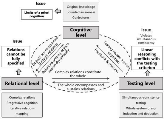
Figure 1.
A holist three-level analytical framework (cognition–relation–testing) and the limitations of linear aggregation under the criterion of simultaneous consistency.
To prevent holism from remaining at an abstract conceptual level, we further operationalize it as a three-level governance chain—the three-level process of cognition–relation–testing—for territorial spatial planning analysis. The cognitive level concerns how spatial values and governance goals are articulated and bounded; the relational level concerns the allocation of authority and responsibilities, coordination mechanisms, and conflict-adjudication procedures across multiple levels, departments, and actors; and the testing level examines whether land-use control, indicator-based constraints, monitoring and evaluation, feedback adjustment, and accountability incentives together constitute an institutional closed loop. The three levels should not be understood as linear steps, but as an iterative “testing–feedback–re-cognition/re-organization” cycle, designed to avoid replacing holistic consistency checks with piecemeal, linear aggregation (Figure 1).
3.2. Feasibility and Necessity of Introducing a Holistic Analytical Perspective
This section explains why a holism-oriented perspective is necessary by situating the discussion in three contexts: the trajectory of domestic scholarship, international trends in spatial governance, and comparisons with related theoretical frameworks. The goal is not to restate the generic claim that “wholeness matters,” but to clarify how holism offers an operational structure, the three-level process of cognition–relation–testing, that can explain institutional evolution and diagnose contradictions that prevent an institutional closed loop, while also specifying what is transferable and where boundary conditions apply.
3.2.1. Domestic Research Trajectory and the Need for Holistic Spatial Governance
In recent years, the transformation of territorial spatial planning in China has prompted extensive scholarly efforts to examine its theories and methods. Much of the literature has focused on technical aspects of plan preparation, including methods for “multi-plan integration,” spatial use regulation, and sectoral planning techniques [9,10,11]. A smaller but growing body of work has explored the key relationships and governing logics that must be clarified during this transformation from a macro-strategic perspective [12], and has reflected on practice-based cases and framework-building for territorial spatial planning reform [13]. These studies provide important theoretical reference points for China’s territorial spatial planning reform; however, the systematic application of holist methodology from philosophy to territorial spatial planning remains underdeveloped.
Moreover, as the planning system evolves, tensions between planning implementation and the approval process for plan revisions have become increasingly salient. These tensions may weaken the authoritative character of planning as a policy instrument and, in turn, reduce the enforceability and driving force of planning proposals. Some scholars have begun to analyze such issues through a holistic lens. For example, Ma Guoqiang and Wang Hongyang draw on theories of urban–rural coordination to construct a scientific paradigm for territorial spatial planning [5,7,8], and further discuss pathways for reform under new-type urbanization [7]. They also reflect on limitations of traditional planning, arguing that existing approaches often fail to exhaust conjectures and exhaust tests [7]. As a result, unresolved issues tend to recur across planning history, contributing to procedural redundancy and increasingly cumbersome workflows.
In the face of complex development challenges, a single planning mindset is insufficient. What is needed is macro-level, reflective thinking that can clarify the mechanisms of the territorial spatial planning system and address the many complex problems arising in urban development. The holistic methodology—through its emphasis on the cognitive, relational, and testing levels—critiques a priori cognition and linear reasoning, and highlights the simultaneity of interdependent local relations, thereby offering a new pathway for tackling complex urban systems.
Building on this gap, the present study contributes a novel analytical framework grounded in philosophical holism, which offers a structured and multi-level perspective (cognition–relation–testing) for understanding the challenges and pathways of territorial spatial planning reform. Unlike prior studies that focus on institutional arrangements or technical methods, this research systematically applies a holistic methodology to trace the evolution of planning practices and propose integrated governance responses aligned with the demands of Chinese-style modernization.
3.2.2. International References, Transferability, and Boundary Conditions
A long-term trend in international research on spatial planning and territorial governance is the shift from technical planning centered on land-use control toward more strategic forms of spatial planning and spatial governance. These approaches place greater emphasis on cross-sector integration, cross-scale coordination, and strategic orientation. To clarify the transferability and boundary conditions of our framework, we draw on typical institutional pathways in Europe, Japan, and the United States as comparative references and extract governance-mechanism problems that recur across different contexts.
In Europe, strategic spatial planning typically relies on multi-level coordination and institutionalized negotiation platforms. A common practice is to link overarching development frameworks with project-based implementation so that cross-jurisdictional goals can be translated into a shared and actionable agenda, strengthening resource integration and joint decision-making capacity [14,15]. In Japan, governance arrangements more explicitly institutionalize development–protection boundaries and procedural requirements in advance. Consultative instruments such as land readjustment, together with supporting procedural rules, help absorb conflicts within a rule-based and negotiated setting and reduce implementation blockage [16,17]. In the United States, land-use governance is highly localized. Under conditions of jurisdictional fragmentation and policy spillovers, cross-boundary coordination often depends on comprehensive plans, regional agreements, or issue-specific cooperation mechanisms. Practice also includes using comprehensive plans to constrain zoning adjustments and adopting checklist-based audits and evaluations to identify gaps between planning texts and implementation instruments, thereby strengthening consistency and accountability [18,19,20].
These differences indicate that institutional trajectories vary, yet spatial governance confronts structurally similar challenges. Multi-objective trade-offs, multi-actor bargaining, and cross-scale coordination frequently generate contradictions among goal boundaries, the organization of authority and responsibilities, and implementation feedback, which can accumulate into implementation drift and weak correction capacity. The transferable component of our framework lies in its diagnostic logic. It uses the three-level process of cognition–relation–testing to locate contradictions among goal boundary-setting, authority–responsibility organization, and closed-loop testing. What requires contextual calibration is primarily the institutional form of the relational level and the testing level, including the strength of local autonomy, statutory procedures and consultative arrangements, fiscal incentives, and accountability mechanisms. On this basis, we distinguish the generalizable components of the framework from those that are specific to China’s institutional context, thereby addressing concerns about external validity and comparative applicability (Table 2).
Table 2.
Transferable components, boundary conditions, and context-specific calibration.
3.2.3. Comparison with Related Theoretical Frameworks: Systems Theory, Complex Adaptive Systems, and Holism
To clarify the theoretical positioning of this study, it is necessary to compare holism with two frameworks frequently used in territorial spatial planning research, namely systems theory (the systems-holistic view) and complex adaptive systems (CAS). The central concern here is practical and governance-oriented: under conditions where multiple administrative levels, multiple departments, and multiple policy instruments coexist, how can planning governance achieve institutional integration, alignment between authority and responsibilities, and a closed implementation loop? The selected theoretical lens therefore needs to offer an operational analytical structure that speaks directly to governance processes. It should also be emphasized that holism, as discussed in this paper, is not opposed to systems theory. Rather, while recognizing systemic wholeness, holism further introduces a testable standard of consistency.
The systems-holistic view takes as its core proposition that a system is an indivisible whole. It highlights interactions among elements, flows of energy and material, and feedback regulation. This perspective provides a solid foundation for understanding the coupled relations among production, living, and ecological spaces, and it cautions planners against managing elements in a fully fragmented manner. Accordingly, the present study does not treat the mere existence of feedback as a sufficient criterion. Instead, we assess whether feedback is institutionalized as a closed-loop mechanism of evaluation–adjustment–accountability, which serves as the operational standard at the testing level.
CAS theory emphasizes multi-actor interaction, nonlinearity, and path dependence. It is well suited to explaining evolutionary processes under uncertainty. However, without explicit consistency testing and institutional carryover, CAS-based accounts can remain at the level of complexity narratives rather than yielding actionable governance implications. By introducing the testing level of holism, this study seeks to translate complexity analysis into an implementable governance closed loop. This translation requires specifying goal boundaries, clarifying authority–responsibility chains, and establishing auditable mechanisms for evaluation and feedback so that governance arrangements can be continuously corrected and improved (Table 3).
Table 3.
Comparison of systems theory, CAS, and holism.
Therefore, the choice of holism in this study does not reject systems theory or CAS. Rather, it highlights the value of “institutional integration and self-consistent testing” when wholeness is translated into a planning-governance context. We operationalize holism as the three-level process of cognition–relation–testing to compare, across stages, changes in goal articulation, authority–responsibility structures, and testing mechanisms, and to identify the contradictions and conflicts that accompany institutional evolution as well as the corresponding pathway for governance integration.
3.3. Spatial Planning and Theory Construction Under the Perspective of Holism
3.3.1. Spatial Planning from a Holistic Perspective
Urban spatial governance is characterized by multi-objective constraints, multi-actor interactions, and cross-scale interdependencies. Under conditions of resource scarcity and externalities, planning and policies oriented toward a single sector or a single element often trigger goal conflicts and implementation misalignments. A holism-oriented perspective treats the city as an integrated whole shaped jointly by element relations and institutional arrangements. From this view, the critical issue in spatial planning is not whether the plan contains more comprehensive lists of items, but whether it can achieve internal coherence and a closed loop across goal-setting, the organization of authority and responsibilities, instrument configuration, and evaluation and feedback.
In the context of governance modernization, spatial planning is both a key vehicle for institutionalizing governmental intent and a comprehensive governance instrument that coordinates public participation, market behavior, and cross-departmental action. Holism requires that, at the cognitive level, planning explicitly specifies spatial values and the development–protection boundary; at the relational level, it clarifies central–local and inter-departmental authority and responsibilities and establishes coordination and conflict-adjudication mechanisms; and at the testing level, it operationalizes an implementable feedback pathway through land-use control, indicator-based constraints, monitoring and evaluation, and accountability-based correction. In this way, “wholeness” is translated into governance mechanisms that are empirically testable.
3.3.2. Theory Construction for Territorial Spatial Planning Under Holism
Introducing holistic methodology reveals that Holism can be applied throughout the full life cycle of territorial spatial planning [2].
At the cognitive level, the objects of cognition include key planning objects such as land functions, resource and environmental carrying capacity, and the spatial carrier (i.e., spatial substrates and infrastructures) through which planning objectives are realized. Cognition of spatial objects matters because understanding relationships among these objects is essential for grasping the properties of the system as a whole: different configurations of elements can generate different system-level outcomes and emergent properties.
At the relational level, relationships in territorial spatial planning can be viewed as a complex network involving multiple levels (e.g., central–local), scales (macro–micro), and types (urban–rural) of planning relations. These relations—and the ideas and techniques used to manage them—should be tested against the functioning of the broader urban system rather than being assessed in isolation [2].
At the testing level, planners should employ a logic of simultaneous consistency to examine the full set of planning relations. Feedback across planning levels should be institutionalized through implementation evaluation, so that central–local and cross-scale relations can be continuously tested for simultaneous consistency. The goal is to iteratively approach a territorial spatial planning system that is “optimal” in a holistic sense.
However, fully operationalizing holistic methodology in China faces challenges due to the country’s vast territory, complex regional conditions, and hierarchical institutional arrangements. Over the historical evolution of planning, planners’ cognitive capacity to understand the composition of spatial objects has varied. As cognition changes, so does the way actors interpret and manage relationships among spatial elements. This makes it necessary to apply holistic methodology to repeatedly test and recalibrate the relational structure of spatial objects in an integrated manner (Figure 2).
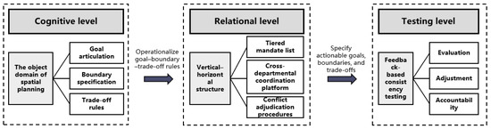
Figure 2.
Theoretical construction of territorial spatial planning under the perspective of holism.
4. Evolutionary Pathway of Planning Innovation Under Chinese-Style Modernization
Across historical stages, China’s territorial spatial planning has followed divergent reform trajectories. Rather than a linear progression, these trajectories reflect long-term processes in which institutional arrangements, the object domain of spatial planning, and the behavior of multiple actors interact, become coupled and reconfigured, and continue to evolve. Accordingly, to unpack the substance and challenges of planning reform under the broader agenda of Chinese modernization, it is insufficient to simply enumerate policy provisions. Instead, socio-economic development dynamics and shifts in the spatial planning system need to be examined within a shared analytical lens, so that changes in the three-level process of cognition–relation–testing and the governance logic underpinning each stage can be systematically identified.
This study also has several limitations. First, we divide the evolution of China’s territorial spatial planning since 1949 into five stages. This stage partition is an analytical choice made to support mechanism-based explanation rather than a single “true” periodization. It is anchored primarily in major national institutional turning points and structural shifts in the toolkit of spatial governance. As a result, alternative periodization schemes, whether coarser or more fine-grained, may lead to different narrative structures, section organization, and stage labels. Second, while the number of stages may alter the narrative architecture, the core focus of this study is not the stages per se, but the structural turning points in the planning logic chain during stage transitions, namely shifts in cognition, relational organization, and testing and feedback. Therefore, as long as structural breaks occur in institutions and authority–responsibility arrangements, governance goals, or the instrument and testing system, the framework developed here retains transferable explanatory power. The five-stage delineation and its institutional turning points are summarized in Appendix A.2 (Table A2).
4.1. A Retrospective Review of the Evolution of Territorial Spatial Planning Innovation
By introducing a holism-oriented perspective, this study adopts the three-level process of cognition–relation–testing as a logic chain that runs through the full cycle of China’s territorial spatial planning, and conducts a staged review of planning evolution since 1949. Specifically, stage boundaries are identified using three criteria:
(1) Institutions and authority–responsibility arrangements. Whether key institutional changes occur that reshape the authority–responsibility structure of spatial governance and the composition of the planning system, such as major reorganizations of the national governance system, the establishment of reform objectives, or significant institutional restructurings.
(2) Governance goals. Whether there is a clear shift in the national development focus and spatial governance goals that redefines the principal contradictions planning is expected to address.
(3) Instruments and testing. Whether testing-level instruments, including land-use control, functional zoning, ecological constraints, monitoring and evaluation, and implementation oversight, undergo systematic upgrading that alters the closed-loop capacity from plan-making to implementation.
4.1.1. “Top-Down Transmission”: Territorial Planning in the Planned-Economy Era (1949–1978)
In the early years of the People’s Republic of China, planning functioned as a component of national economic planning and served to translate national economic plans into spatial arrangements [21]. Under conditions of scarce resources, planning acted as an implementation instrument: it coordinated the allocation of resources and the scheduling of construction projects, and promoted rapid economic development through top-down administrative mobilization and dispatching [22]. Constrained by the broader historical and institutional context, territorial spatial planning had not yet developed into a comprehensive system with rich substantive content. Moreover, the state had not yet recognized the full range of values embodied in land resources. Land was largely treated as a free input and supplied through planned allocation. Overall, planning in this period was characterized by strong top-down transmission and rigid, high-intensity constraints.
4.1.2. Reform Experimentation: System-Building During the Reform and Opening-Up Period (1978–1992)
After the 1978 Reform and Opening-up, the national priority shifted toward economic development. Under the early “dual-track” economic system, commodity production and exchange began to expand. The role of mandatory state planning directives gradually diminished, while market-based adjustment mechanisms expanded [21]. The production and operational autonomy of collective and other actors was gradually activated, stimulating the growth of township and village enterprises and foreign-invested enterprises, and generating demand for the emergence and supply of various development-oriented spatial plans [23]. As planning practice diversified, China’s spatial planning system entered a phase of experimentation and consolidation. Urban planning was further restored, and a pattern of “multi-plan coexistence” gradually took shape, including national land planning, urban–rural planning, and land-use planning.
During this period, spatial planning had not yet formed a unified preparation framework. Nevertheless, clearer functional divisions among government departments and a predominantly top-down planning arrangement enabled relatively effective macro-level steering of national development and construction. Building on the inherited top-down transmission model, spatial planning also expanded its substantive scope, moving beyond the rigid “upload–download” style of the planned-economy era and improving coordination of regional development and resource allocation.
4.1.3. Coexistence of Multiple Plans: The Urban “Growth Machine” Under the Market System (1992–2010)
Following the establishment of the socialist market economy in 1992 and the 1994 tax-sharing reform, local governments increasingly treated spatial planning as an instrument for economic growth, ushering in an era of entrepreneurial urban development]. Changes in land-use arrangements reshaped central–local relations and were accompanied by a broader decentralization of authority from the central government to local governments [24].
Planners’ understanding of the planning system shifted accordingly—from serving centralized macro-level transmission to prioritizing local, growth-oriented agendas. This contributed to a landscape of “multiple plans in parallel,” including urban master plans, urban–rural plans, and district/zoning plans. These plans became key implementation tools for meeting local governments’ demands for rapid development [25].
Market- and land-system reforms also encouraged patterns of extensive and, at times, disorderly urban expansion, with substantial occupation of land resources and cultivated land. In response, the state established land administration institutions (e.g., the State Land Administration) to curb such trends and to emphasize the rational use of land resources. This institutional response also highlights an enduring bargaining dynamic between local governments’ demand for spatial expansion and the central government’s macro-level regulation.
4.1.4. Overlapping Mandates: Contradictions and Conflicts During the Development Transition (2010–2018)
Following the Third Plenary Session of the 18th CPC Central Committee, which called for advancing the “modernization of the national governance system and governance capacity,” China’s development strategy gradually shifted toward ecological civilization. Guided by this strategic turn, the spatial planning system underwent multiple lines of experimentation. For example, the National Development and Reform Commission (NDRC) categorized territorial space into four functional zones—optimized development, key development, restricted development, and prohibited development—thereby strengthening land-use regulation [26]. Urban planning also evolved from a primarily physical/spatial tool toward a more comprehensive form of planning that guides urban development, emphasizing its role as a form of public policy. To further strengthen constraints related to land resources and the ecological environment, relevant departments, building on the existing natural-resource and environmental management system, promoted exploratory and institutional arrangements for more comprehensive planning oriented toward land-resource regulation and ecological protection.
However, as urbanization deepened and both elements and actors multiplied, cross-cutting and overlapping administrative mandates intensified. Conflicts became more pronounced not only between different plans, but also between planning and implementation. These tensions reflect frictions in action among central and local governments as well as among sectoral agencies, and reveal the deeper contradictions and conflicts among multiple actors during China’s transitional development period.
4.1.5. Multi-Plan Integration: Territorial Spatial Planning Under the Modernization of National Governance (2018–Present)
In the new era, China must not only address problems carried over from the transitional period but also respond to a higher-order development agenda—particularly the major social contradiction between “people’s growing needs for a better life” and “unbalanced and inadequate development”. Against this backdrop, the functional positioning of planning, as well as its cognitive foundations, relational structure, and testing approaches, have been reshaped.
To better realize spatial planning as public policy in support of Chinese-style modernization; to clarify central–local and inter-local relationships so that spatial interventions can be implemented more effectively at local and micro scales; to delineate responsibilities among government, market, and society and enable stronger market and societal adjustment within planning practice; and to advance the modernization of development and governance capacity, the state advanced institutional restructuring after pilot reforms [26,27]. In particular, urban–rural planning functions were incorporated into the newly established Ministry of Natural Resources, and a unified territorial spatial planning system was created to implement unified land-use control across urban and rural areas, with a focus on resolving overlaps and fragmentation among plans [28].
4.2. Innovation Pathways in the Evolution of Spatial Planning from a Holistic Perspective
4.2.1. Attribute Cognition: From Partial Understanding Toward More Comprehensive and Continuous Development
The cognitive level of China’s urban planning has undergone continuous development and transformation, shaped by—and often contested against—changing historical contexts [29]. Constrained by the institutional environment of each era as well as the limits of individual cognition, understanding of spatial attributes has often fallen short of a fully holistic grasp. Space is inherently composite and multi-dimensional, and its meanings and functions evolve dynamically over time, making comprehensive understanding difficult.
In China, planning practice has shifted from serving as a passive instrument for implementing national plans to acting as a proactive program for guiding development, and more recently to functioning as public policy aimed at mediating tensions between economic growth and environmental protection. Accordingly, the evolution of spatial-planning cognition in the People’s Republic of China has co-evolved with national political–economic development and with the interaction between domestic and international planning ideas. Cognition has shifted from viewing space primarily as a carrier for economic production toward treating planning as a policy framework for regulation and constraint, reflecting strong historical contingency. Importantly, cognitive change across periods has been largely cumulative rather than purely discontinuous: new understandings have selectively rejected, revised, and layered upon earlier conceptions.
As development stages and governance priorities shift, space is gradually redefined. It moves from being treated primarily as a medium for economic production and construction to a governance object that simultaneously carries development, protection, and the coordination of public interests [30]. Correspondingly, its value dimensions evolve from singular to composite. This cognitive evolution does not fully replace earlier understandings. Instead, it proceeds through additive correction, typically by introducing new goals, institutionalizing boundary constraints, and unifying conceptual terms and policy language. In this way, it provides a shared cognitive basis for subsequent arrangements of authority and responsibilities and for implementation testing.
4.2.2. Relational Structuring: From Single-Objective Service to a Pluralistic Governance System
A retrospective review of China’s spatial planning evolution suggests a gradual shift from serving a single objective within relatively simple relationships to operating as a pluralistic governance mode embedded in complex relational logics. Given the inherent complexity of cities, local elements and their interconnections are continually recombined, and societal understandings of these relations evolve accordingly.
In its early phase, spatial planning primarily served to translate the national will into spatial arrangements. Later, with the establishment of the socialist market economy, the objectives of spatial planning shifted toward supporting local governments’ growth-oriented development agendas. In the more recent period, the objectives of spatial planning have become increasingly diversified. This diversification is reflected in the emergence of multiple planning instruments designed to address new issues, such as urban-system plans oriented toward urban–rural integration, ecological and environmental protection plans focused on environmental governance, and land-use plans emphasizing land-use regulation and control.
The deeper logic behind this proliferation is that, when national development encounters bottlenecks and enters periods of transition, governance actors attempt to address complex problems by reconfiguring and innovating at the relational level, by redefining how objectives, actors, and instruments are connected and coordinated.
4.2.3. Feedback and Testing: From Fragmented Management to Centralized Governance
After establishing cognition of planning objects and structuring planning relations, governance construction must further test these relations against the criterion of simultaneous consistency through feedback mechanisms. The recent reform of territorial spatial planning—centered on “multi-plan integration”—can be understood as an evolutionary shift from fragmented, sector-based management toward more centralized and coordinated governance.
Before multi-plan integration, planning-related agencies in China were organized around distinct sectoral mandates. Administrative responsibilities were fragmented, and agencies tended to prioritize their own departmental interests, resulting in siloed governance and “each acting on its own.” The dispersion of subsystems made the overall planning system increasingly cumbersome and complex, which in turn severely weakened implementation effectiveness [31].
By contrast, today’s multi-plan integration and the renewed emphasis on urban–rural coordination reflects a long-term trajectory of institutional learning: from early administrative land allocation to decentralization and two-level (central–local) management, and toward a planning regime that seeks to balance development and protection through systematic testing and adjustment. In this sense, the move toward integrated territorial spatial planning marks a transition from dispersed arrangements toward centralized governance, and can be interpreted as an ongoing process of testing and strengthening simultaneous consistency across planning objectives, actors, and scales.
Without institutionalized testing and feedback-based correction, planning is prone to implementation drift under multi-objective pressure. This can produce, on the one hand, a gap between extensive plan-making and weakened implementation and, on the other hand, an accumulation of externalities and rising conflict costs as multiple departments pursue project-based initiatives in parallel.
5. Challenges and Governance Responses in Spatial Planning Reform Under Chinese-Style Modernization
5.1. Real-World Challenges of Planning Reform
Several governance problems identified in China’s territorial spatial planning reform are not unique to China. Internationally, spatial planning has long grappled with tensions between development and protection, unclear cross-level allocations and transmission of authority and responsibilities, and implementation failures driven by multi-actor conflicts. The holism-oriented analytical framework proposed in this study is therefore valuable not only for explaining China’s reform, but also for clarifying which components of the framework are transferable across institutional settings and which institutional forms require contextual calibration. In doing so, it offers international readers a reference point for comparison and application.
5.1.1. The Development–Protection Tension
The tension between development and protection is deeply embedded in the evolution of spatial planning. As different historical understandings of spatial attributes have accumulated and overlapped over time [2], the development–protection contradiction has become increasingly salient. Since 2018, China’s territorial spatial planning has advanced multi-plan integration and has placed greater emphasis on ecological civilization and sustainability. Yet the system still struggles to resolve the paradox between development and protection.
A key manifestation of this paradox lies in the prevailing “dual-evaluation” approach—resource and environmental carrying capacity and territorial spatial development suitability. In practice, areas assessed as having the best carrying capacity and highest suitability are often also the areas subject to the strongest development pressure. This indicates an internal tension between the protection and development logics embedded in the dual-evaluation framework [32].
Without a unified specification of goal boundaries and auditable trade-off rules, the development–protection tension readily translates into institutional conflict at the implementation level. Typical manifestations include inconsistent approval standards, context-dependent project selection, and fragmented boundary adjustments, which in turn undermine planning authority and accumulate ecological and development risks. The key issue in planning is thus not to “cover more content,” but to embed trade-off rules in auditable institutional instruments so that the development–protection relationship can be implemented and corrected in a testable manner [7].
5.1.2. The Challenge of Governance Coherence Under Chinese-Style Modernization
At present, horizontal competition among sectoral departments and vertical conflicts over administrative authority across levels of government make territorial spatial planning difficult to implement effectively. China’s territorial spatial planning reform has been launched in part to address these complex coordination problems. However, in terms of implementation outcomes, reform efforts have tended to focus more on mitigating horizontal competition and redundancies among departments, while adjustments to vertical authority and responsibilities across governmental levels have largely remained at the level of defining the hierarchical structure of plan preparation. Governance responses that would secure vertical coherence in authority and responsibility remain insufficient [33].
Within this reform context, the “One Map” strategy aims to strengthen land-use control capacity and to institutionalize ecological-civilization values. Yet “One Map” is designed to integrate the full set of planning outputs across the “five levels and three categories” system, which implies an extensive and resource-intensive effort to achieve comprehensive territorial spatial coverage [26]. Accordingly, vertical coherence depends on placing goal decomposition, mandate allocation, resource matching, and accountability and feedback within a single institutional chain.
5.1.3. Conflicts Among Complex Relations
Because cognition of planning practice and urban development is inherently incremental and evolves over time, a plan that has been implemented for some period may no longer match the changing needs of urban development. This can generate contradictions between planning and development that often manifest as conflicts among urban spatial elements. At a deeper level, these are conflicts among complex relations within the territorial spatial planning system.
First, across the historical process of plan preparation, spatial planning inevitably accumulates unresolved legacy issues from earlier plans. As the system evolves, these issues overlap and interact, producing increasingly complex conflicts. Multi-plan integration aggregates multiple plans into one framework; however, such aggregation can also constrain the specificity and problem-solving capacity of individual sub-plans. As the number of plans and the density of inter-plan relations increase, contradictions may multiply—implying that additional conflicts could emerge in the future.
Second, territorial spatial planning reform has established a more comprehensive regulatory system and has emphasized linking “areas” and “elements.” Yet because localities differ in their practical understanding and implementation capacity under multi-plan integration, it is often difficult to translate and connect area-based territorial spatial planning (typically at higher levels) with element-based territorial spatial planning (typically at lower levels) [34]. This may lead to overlaps and mismatches between area-based and element-based spatial controls. For example, the delineation of ecological space may include both contiguous protected areas and “scattered” spaces associated with human activities; it can therefore simultaneously contain area-based spatial controls and element-based controls that emphasize natural attributes [35].
Third, divergences in cognition and relational structuring regarding key concepts can produce inconsistent approaches to delineating the “Three Zones and Three Control Lines”. In China’s territorial spatial planning, the “Three Zones and Three Control Lines” refers in particular to the ecological protection redline, permanent basic farmland, and the urban development boundary. Such inconsistency can, in turn, create difficulties for subsequent implementation, coordination, and approval processes.
5.1.4. Grasping the Whole and the Parts
As cities enter a phase characterized by stock-based transformation and overlapping risk constraints, the central challenge of planning governance is no longer incremental technical improvement within a single domain. Rather, it is how to prevent partial policies and project-based actions from generating cumulative externalities at the system level. For example, point-based renewal or the achievement of indicators within isolated projects may produce, at the regional scale, functional mismatches, fragmented ecological connectivity, or uneven public service provision, thereby offsetting governance gains at larger scales [36]. Although recent territorial spatial planning reform has sought to remove problems embedded in earlier cognition and practice—by unifying plan preparation and establishing a more coherent top-level institutional architecture [26]—implementation still faces a fundamental challenge: in practice, it is difficult to fully understand the systemic mechanisms through which urban systems evolve. This limitation can lead to an overemphasis on local, piecemeal planning adjustments.
For example, government-funded programs intended to improve urban–rural living environments may alter local social and cultural structures, but such changes are often driven by external inputs rather than endogenous dynamics. Therefore, identifying, clarifying, and constructing the mechanisms of territorial spatial planning that can support Chinese-style modernization is necessarily a large-scale, complex, and long-term process. As urban systems become increasingly complex, there is an urgent need to explore planning intervention strategies that can maximize overall benefits at the system level.
5.2. Solutions for Modernization-Oriented Governance from a Holistic Perspective
5.2.1. Governance Responses for Balancing Development and Protection
The governance key to the development–protection tension lies in institutionalizing trade-off rules in a way that is testable, rather than leaving them at the level of principle-based advocacy. At the cognitive level, the relative weighting and boundary constraints embedded in the “ecological civilization–high-quality development” agenda need to be translated into an actionable pathway. This requires specifying the applicable objects of baselines and red lines, the conditions under which adjustments are permitted, and the procedures for exceptions, so as to avoid divergent interpretations of concepts and boundaries across departments and regions [7]. At the relational level, boundary instruments such as the “Three Zones and Three Control Lines” should serve as the core organizing device for establishing differentiated control rules inside and outside boundaries, together with checklist-based implementation pathways.
In addition, institutional arrangements for regulating the development–protection relationship should be strengthened. For example, the regulatory rules for the “Three Lines” should be fully aligned with the existing territorial spatial planning system. Priority should be given to identifying and strictly protecting key elements in critical protection areas, while other areas should allow orderly development tailored to local conditions. Within the urban development boundary, regulatory enforcement for instruments such as the Green Line (green-space control line) and Blue Line (water-body protection/control line) should be strengthened. Outside the development boundary, protection boundaries for basic forestland, basic grassland, wetlands, and other ecological assets should be clearly delineated; at the same time, development boundaries for settlements, key infrastructure, construction activities, and resource extraction should be specified [37]. Finally, efforts should be made to establish a coherent development–protection control system—such as the “three basics + one water + two lines” and the “two boundaries + one zone + five networks” frameworks—to support healthy and sustainable spatial governance [38].
At the testing level, the “Two Evaluations” and boundary control should be embedded within a unified closed loop of evaluation–adjustment–accountability. This entails regularly releasing monitoring and evaluation results, defining procedural triggers for boundary optimization or indicator recalibration, and clearly specifying responsible actors and correction timelines. In this way, development–protection coordination no longer depends on ad hoc bargaining, but becomes an institutional arrangement with sustained corrective capacity. In terms of transferability, the core of this pathway lies in “auditable trade-off rules, executable boundary instruments, and coordinated feedback mechanisms,” while the specific institutional forms can be calibrated to different legal and fiscal systems across countries. An operational toolkit mapping is provided in Appendix A.5 (Table A5). An operational toolkit mapping is provided in Appendix A.5 (Table A5). As illustrated by the Shenzhen coding example (Section 2.6; Table A4), baseline boundary specification, procedural conflict handling, and monitoring/evaluation interfaces can be coded as cognition–relation–testing signals, showing how the pathway is operationalized at the clause level.
5.2.2. Coherence and Complex Relations
The governance priority for achieving internal coherence in spatial planning is to repair vertical authority–responsibility chains and horizontal coordination mechanisms simultaneously, and to anchor both in a stable feedback regime. At the relational level, this requires establishing tiered rules for the allocation and transmission of authority and responsibilities. Central and provincial levels should concentrate on baseline constraints, resource protection, and the standardized specification of key indicators, while municipal and county levels should translate higher-level constraints into project lists and implementation sequencing and, based on local endowments, submit traceable adjustment proposals [39]. Institutionalized consultation platforms and conflict-adjudication procedures are also needed to clarify how inter-departmental disputes are processed and to avoid reliance on ad hoc meetings as the default coordination device.
To support Chinese-style modernization, it is necessary to establish a rational top-down transmission mechanism and to allocate administrative authority and responsibilities across governmental levels in a coherent manner. This implies building a differentiated territorial spatial planning system that is functionally specialized and tiered by levels, so that each level can perform its appropriate role. It is also essential to construct interactive feedback mechanisms among actors [40]. At upper levels (central and provincial), planning should emphasize macro-level arrangements such as territorial control, resource protection, and indicator setting. At lower levels (municipal and county), planning should focus on implementing upper-level guidance while designing spatial structures that fit local endowments and conditions. Such arrangements can improve coordination among plans and across levels, enabling territorial spatial planning to shift from “local adjustments” toward “overall optimization,” and thereby strengthen effective policy transmission (Figure 3).
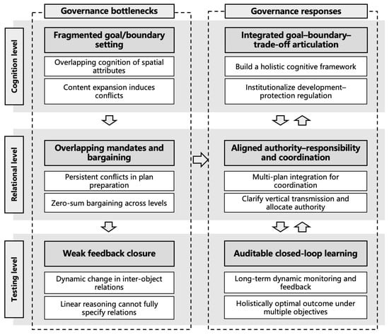
Figure 3.
Shift in the analytical thinking of territorial spatial planning from a holistic perspective.
At the testing level, planning implementation should be embedded in a full life-cycle closed loop of evaluation–adjustment–accountability. Auditable evaluation indicators and procedural triggers should be specified for major stages including plan preparation, approval, implementation, and review. The procedures, timelines, and responsible actors for feedback-based correction should be clearly defined. In addition, public participation, information disclosure, and third-party evaluation should be treated as procedural safeguards that enhance acceptability and reduce implementation risks.
In urban renewal, establishing a routine mechanism that organizes relevant stakeholders to participate throughout the planning process can help test the consistency of complex relations among actors in practice. This can support holistically optimal outcomes under multiple objectives and, ultimately, contribute to Chinese-style modernization (Figure 4).
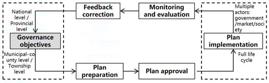
Figure 4.
Holistic perspective on the territorial spatial planning system.
5.3. Comparative Implications and Boundary Conditions
The proposed framework, the three-level process of cognition–relation–testing, is not intended to export a China-specific institutional blueprint that others can replicate. Its purpose is to provide a comparative diagnostic approach to spatial governance. Under conditions of multiple objectives, particularly the development–protection tension, and multiple actors across levels and departments, governance problems often arise from inconsistencies among goal boundaries, the organization of authority and responsibilities, and implementation testing. Such inconsistencies allow implementation deviations to accumulate and can weaken corrective capacity.
In terms of transferability, the most portable component is the diagnostic lens itself. At the cognitive level, the framework emphasizes clarifying spatial values, governance goals, and the boundary constraints that structure them, including the scope of objects, core concept specification, baseline boundaries, and trade-off rules. At the relational level, it asks whether authority–responsibility chains are clear, whether stable coordination and conflict-adjudication mechanisms exist, and whether higher-level constraints can be translated into executable lower-level rules and checklist-based instruments. At the testing level, it focuses on whether land-use control, monitoring and evaluation, feedback adjustment, and accountability incentives jointly form a triggerable institutional closed loop. Wherever structurally similar conflicts exist, the framework can be used as a diagnostic tool to locate contradictions and organize reform priorities.
What requires contextual calibration is primarily institutional form rather than diagnostic logic. Central–local relations and the degree of local autonomy, legal and procedural traditions, fiscal incentives and performance assessment practices, and baseline data and technical capacity all shape how consultation platforms are designed, how binding control rules can be, and how evaluation results trigger adjustment and accountability. A more appropriate use of the framework is therefore to identify “chain gaps” and then assemble a locally compatible package of instruments.
The China case suggests a two-sided lesson. Strong capacity for institutional integration facilitates unified goal articulation and the establishment of coherent control systems. At the same time, pronounced regional heterogeneity and long vertical transmission chains can amplify the difficulty of achieving internal coherence in governance. This implies that comparative research should attend simultaneously to institutional arrangements that enable unified rules and to mechanisms that allow differentiated adaptation.
6. Conclusions and Discussion
This study identifies three recurrent bottlenecks in China’s territorial spatial planning reform at the cognitive, relational, and testing levels, which together explain why conflicts and implementation slippage persist even as institutional integration advances. It then conducts a comparative analysis across five historical stages since 1949, drawing on evidence from changes in policy institutions and planning governance mechanisms [26,29,41,42].
6.1. Key Governance Bottlenecks: Three Types of Chain Misalignment
Based on the five-stage comparison since 1949, the reform’s key bottlenecks concentrate in three recurrent types of governance-chain misalignment. At the cognitive level, goal articulation, boundary specification, and core concept specification are not to fully standardized across administrative levels and sectoral departments, repeatedly generating implementation tensions around development–protection trade-offs [1,4,38]. At the relational level, mandates, responsibilities, and incentives are misaligned across levels, while cross-departmental coordination mechanisms remain unstable. Policy intent dissipates through vertical transmission and horizontal bargaining, coordination costs rise, and implementation outcomes become increasingly contingent on situational pressures [12]. At the testing level, the evaluation–adjustment–accountability mechanism is not institutionalized as a stable procedure. Evaluation therefore remains at problem identification and does not reliably activate formal adjustment processes or produce clear accountability consequences, allowing deviations to accumulate over time and eroding planning authority [1,43]. These three misalignments explain the persistence of conflicts and implementation slippage even as institutional integration advances.
Relative to existing research, this paper makes three contributions. First, whereas studies structured around multi-plan integration often focus on the sources of conflict, principles of institutional integration, and “One Map” practice [44,45,46], this paper provides a verifiable chain-based consistency-testing approach. It examines goal boundaries, authority and coordination arrangements, and evaluation, feedback, and accountability within one governance chain. This approach diagnoses why conflicts re-emerge at the implementation stage and specifies where corrective action must be institutionally triggered. Second, compared with research that emphasizes system construction, operational strategies, and the mapping of relations among planning, land-use control, and natural-resource regulation [47,48], this paper shifts the analytical focus from system design to implementation operability. It treats triggerable evaluation–adjustment–accountability procedures as a criterion for implementation predictability and corrective capacity, and it shows that the absence of such procedures underlies recurrent implementation slippage [49]. Third, in contrast to work that depicts governance complexity through abstract “relationship inventories” [12], this study uses framework-guided coding to translate relational complexity into a diagnostic typology of misalignment, including unclear authority and responsibilities, missing coordination, and incentive misfit. Linking these diagnoses to testing-level mechanisms moves the analysis from describing complexity to identifying actionable correction points for reform prioritization.
6.2. International Applicability and Boundary Conditions
The framework developed here supports comparative diagnosis in spatial planning and territorial governance beyond China, and it is designed for mechanism-based assessment rather than institutional replication [50]. The three-level criteria have general relevance for evaluating governance-chain coherence. The cognitive level specifies whether goals and boundaries are institutionally defined, including the scope of planning objects, core concept specification, baseline constraints, and trade-off rules. The relational level assesses cross-level and cross-departmental authority–responsibility chains, coordination platforms, and conflict-adjudication mechanisms [12]. The testing level assesses whether land-use control and implementation instruments are integrated with monitoring and evaluation, feedback adjustment, and accountability and incentive mechanisms to form a closed loop [26]. Under conditions of development–protection tensions, authority–responsibility conflicts, and weak implementation feedback, these criteria locate contradictions along the governance chain and structure reform priorities.
Contextual calibration concerns institutional form rather than the diagnostic logic itself. Central–local relations and local autonomy, legal and procedural traditions, fiscal incentives and performance assessment practices, and baseline data and technical capacity condition institutional design choices [26]. These factors shape consultation platforms, the binding force of control rules, the procedural conditions for using evaluation results to trigger adjustment, and the feasible combinations of accountability instruments. The China case illustrates this distinction. Strong integration capacity supports unified basemaps and standardized policy language, while pronounced regional heterogeneity and long vertical transmission chains can amplify the difficulty of maintaining internal coherence. The comparative implication is that reforms aimed at reducing fragmentation and implementation drift prioritize three shared conditions, namely clarifying goal boundaries, institutionalizing authority–responsibility coordination, and proceduralizing closed-loop testing [51]. Within these common conditions, jurisdictions can select instrument packages that fit local institutional constraints and remain executable, auditable, and correctable, rather than replicating institutional arrangements in form.
6.3. Study Limitations
This study also has limitations. Stage delineation and text interpretation inevitably involve researcher judgment, and the analysis relies primarily on national-level institutional and policy texts, leaving limited quantitative testing of local variation and implementation performance. A feasible next step is to “ground” the comparative agenda while maintaining the same framework. On the one hand, future work can extend local-level institutional materials and bring in data on project approval and land-use control, monitoring and evaluation outputs, and accountability records to test how the three-level chain operates in practice. On the other hand, comparative studies across institutional settings can apply a shared diagnostic lens while varying instrument packages, assessing which institutional arrangements most effectively strengthen chain performance, reduce conflict costs, and curb implementation deviations. In this way, external validity can move from being plausible and interpretable to being empirically testable, while building a more operational comparative evidence base for institutional reform in urban planning.
Author Contributions
Conceptualization, C.H. and Z.Z.; methodology, C.H.; software, Z.Z.; validation, C.H., Z.Z., P.Z. and X.Z.; formal analysis, Z.Z.; investigation, C.H.; resources, Z.Z.; writing—original draft preparation, C.H.; writing—review and editing, Z.Z.; visualization, Z.Z.; supervision, X.Z.; project administration, P.Z.; funding acquisition, P.Z. All authors have read and agreed to the published version of the manuscript.
Funding
This research was funded by the National Natural Science Foundation of China (Grant No. 52578086).
Institutional Review Board Statement
Not applicable.
Informed Consent Statement
Not applicable.
Data Availability Statement
Data are contained within the article.
Conflicts of Interest
The authors declare no conflicts of interest.
Appendix A. Traceable Evidence Base and Coding Materials
Appendix A.1. Policy and Institutional Corpus Inventory (1949–Present)
This appendix lists the full set of policy and institutional documents used to construct the textual corpus for analysis, organized by historical stage and uniquely indexed for traceability and replication.
Table A1.
Policy and Institutional Document Inventory by Stage (1949–Present).
Table A1.
Policy and Institutional Document Inventory by Stage (1949–Present).
| Section/Notes | Policy ID | Year | Level | Document Type | Material Type | Document/Material Title |
|---|---|---|---|---|---|---|
| Stage I (1949–1978).Planned Economy | [National: Laws/Resolutions/Plans/Notices (codable texts, D)] | |||||
| N01 | 1947 | National | Law | D | 《中国土地法大纲》 | |
| N02 | 1950 | National | Law | D | 《中华人民共和国土地改革法》 | |
| N05 | 1953 | National | Meeting Decision/Resolution | D | 《关于农业生产互助合作的决议》 | |
| N07 | 1955 | National | Development Plan/Five-Year Plan | D | 《中华人民共和国发展国民经济的第一个五年计划 (1953–1957)》 | |
| N08 | 1956 | National | Plan/Outline | D | 《1956–1967年全国农业发展纲要 (农业发展纲要 40 条)》 | |
| N10 | 1956 | National | Policy Document/Regulation | D | 《区域规划编制与审批暂行办法 (草案)》 | |
| N11 | 1958 | National | Policy Document/Regulation | D | 《关于工作方法 60 条 (草案)》 | |
| N12 | 1958 | National | Meeting Decision/Resolution | D | 《关于在农村建立人民公社问题的决议》 | |
| N13 | 1958 | National | Policy Document/Regulation | D | 《关于开展人民公社土地利用规划工作的通知》 | |
| N15 | 1965 | National | Other | D | 《关于第三个五年计划安排情况的汇报提纲》 | |
| N16 | 1977 | National | Other | D | 《关于经济计划的汇报要点》 | |
| [National: Institutional events/milestones (non-codable, E)] | ||||||
| N03 | 1952 | National | Institutional Event/Milestone | E | 黑龙江省集贤县三道岗地区开展土地区划 | |
| N04 | 1952 | National | Institutional Event/Milestone | E | 农业部成立国营农场管理总局 | |
| N06 | 1954 | National | Institutional Event/Milestone | E | 友谊农场建立: 首次有组织地开展土地利用规划工作 | |
| N09 | 1956 | National | Institutional Event/Milestone | E | 成立农垦部, 统一管理军垦农场与地方国营农场 | |
| N14 | 1959 | National | Institutional Event/Milestone | E | 农业部提出“边普查、边规划、边行动…将成果落实到生产中” | |
| N17 | 1978 | National | Institutional Event/Milestone | E | 土地利用局设立 (后改称土地管理局) | |
| Stage II (1978–1992). Reform exploration/system experimentation | [National: Laws/Ordinances/Notices/Rules (codable texts, D)] | |||||
| N19 | 1982 | National | Policy Document/Regulation | D | 《县级土地利用总体规划要点》 | |
| N20 | 1984 | National | Meeting Decision/Resolution | D | 《关于经济体制改革的决定》 (十二届三中全会) | |
| N21 | 1986 | National | Policy Document/Regulation | D | 《关于加强土地管理制止乱占耕地的通知》 | |
| N22 | 1986 | National | Law | D | 《中华人民共和国土地管理法》 | |
| N23 | 1987 | National | Policy Document/Regulation | D | 《关于开展土地利用总体规划的通知》 | |
| N24 | 1987 | National | Ordinance/Regulation | D | 同年多项配套: 全国规划纲要/编制审批办法/县规程/耕地占用税/建设用地办法/联合通知等 | |
| N26 | 1989 | National | Policy Document/Regulation | D | 《关于加强省级国土规划工作的通知》 | |
| N27 | 1990 | National | Plan/Outline | D | 《全国国土总体规划纲要 (草案)》 | |
| N28 | 1990 | National | Law | D | 《中华人民共和国城市规划法》 | |
| [National: Pilot programs/institutional milestones (non-codable, E)] | ||||||
| N18 | 1980 | National | Institutional Event/Milestone | E | 第二次农业区划会议: 县级土地利用总体规划试点启动 (多县试点) | |
| N25 | 1988 | National | Institutional Event/Milestone | E | 全国城市、县城总体规划基本完成 | |
| [Shenzhen: master plans/general plans (codable texts, D)] | ||||||
| S01 | 1980 | Shenzhen | Plan/Outline | D | 《深圳市经济特区城市发展纲要》 | |
| S02 | 1982 | Shenzhen | Plan/Outline | D | 《深圳经济特区社会经济发展规划大纲》 | |
| S03 | 1984 | Shenzhen | Urban Master Plan | D | 《总规 (1986)》 | |
| S04 | 1985 | Shenzhen | Specialized Plan | D | 《深圳特区道路交通规划》 | |
| S05 | 1990 | Shenzhen | Specialized Plan | D | 《深圳市城市规划标准与准则》 | |
| Stage III (1992–2010s). Parallel plans/growth-oriented governance | [National: Laws/ordinances/plan outlines (codable texts, D)] | |||||
| N29 | 1993 | National | Plan/Outline | D | 《全国土地利用总体规划纲要》草案 | |
| N30 | 1993 | National | Meeting Decision/Resolution | D | 《中共中央关于建立社会主义市场经济体制若干问题的决定》 | |
| N31 | 1993 | National | Ordinance/Regulation | D | 《村庄和集镇规划建设管理条例》 | |
| N32 | 1994 | National | Ordinance/Regulation | D | 《基本农田保护条例》 | |
| N34 | 1996 | National | Policy Document/Regulation | D | 《关于加强城市规划工作的通知》 | |
| N35 | 1998 | National | Law | D | 《中华人民共和国土地管理法》 (1998修订) | |
| N36 | 2003 | National | Plan/Outline | D | 《全国土地利用总体规划纲要 (2003–2020)》 | |
| N38 | 2008 | National | Law | D | 《城乡规划法》 | |
| N39 | 2008 | National | Policy Document/Regulation | D | 《国务院关于印发全国土地利用总体规划纲要 (2006―2020年) 的通知》 | |
| N40 | 2010 | National | Plan/Outline | D | 《全国主体功能区规划》 | |
| [National: macro-institutional turning points (non-codable, E)] | ||||||
| N33 | 1994 | National | Institutional Event/Milestone | E | 分税制改革 | |
| N37 | 2006 | National | Institutional Event/Milestone | E | “十一五”纲要首次官方使用“国土空间”概念 | |
| [Shenzhen: master plans/general land-use plans (codable texts, D)] | ||||||
| S06 | 1998 | Shenzhen | Ordinance/Regulation | D | 《深圳市城市规划条例》 | |
| S07 | 2000 | Shenzhen | Urban Master Plan | D | 《总规 (1996)》 | |
| S08 | 2002 | Shenzhen | Specialized Plan | D | 《深圳2030城市发展策略》 | |
| S09 | 2006 | Shenzhen | General Land-Use Plan | D | 《深圳市土地利用总体规划 (2006–2020年)》 | |
| S10 | 2009 | Shenzhen | Specialized Plan | D | 《深圳市城市更新规划》 | |
| S11 | 2010 | Shenzhen | Urban Master Plan | D | 《深圳市城市总体规划 (2010–2020)》 | |
| Stage IV (2010–2018). Coordination trials under fragmentation | [National: central documents/plans (codable texts, D)] | |||||
| N41 | 2010 | National | Central Document/Planning Proposal | D | 《关于制定国民经济和社会发展第十二个五年规划建议的说明》 | |
| N42 | 2014 | National | Plan/Outline | D | 《国家新型城镇化规划 (2014–2020年)》 | |
| N43 | 2014 | National | Policy Document/Regulation | D | 《关于开展市县“多规合一”试点工作的通知》 | |
| N44 | 2015 | National | Central Document/Planning Proposal | D | 《中共中央关于制定国民经济和社会发展第十三个五年规划的建议》 | |
| [National: reform milestones and concept formation (non-codable, E)] | ||||||
| N45 | 2011 | National | Institutional Event/Milestone | E | “十二五”科技发展规划首次出现“国土空间规划”概念 | |
| N46 | 2013 | National | Institutional Event/Milestone | E | “多规合一”改革试点阶段启动 (以十八届三中全会/中央城镇化工作会议为标志) | |
| N47 | 2013 | National | Institutional Event/Milestone | E | 中央城镇化工作会议: 国家规划与市场力量“两只手” | |
| N48 | 2014 | National | Institutional Event/Milestone | E | 市县级“多规合一”试点推进 | |
| N49 | 2015 | National | Institutional Event/Milestone | E | 首批省级空间规划暨“多规合一”试点 (海南、宁夏) | |
| [Shenzhen: related studies/thematic plans (codable texts, D)] | ||||||
| S12 | 2010 | Shenzhen | Urban Master Plan | D | 《深圳市城市总体规划 (2010–2020)》 | |
| S13 | 2012 | Shenzhen | Implementation Rules/Normative Document | D | 《深圳市城市更新办法实施细则》 | |
| S14 | 2016 | Shenzhen | Supporting Study/Thematic Research | D | 《深圳 2035 城市总体规划—城市设计新理念 (2016–2035)》 | |
| Stage V (2018–present). Territorial spatial planning system restructuring | [National: top-level institutions/guidelines/standards (codable texts, D)] | |||||
| N50 | 2019 | National | Policy Document/Regulation | D | 《中共中央国务院关于建立国土空间规划体系并监督实施的若干意见》 | |
| N51 | 2020 | National | Guideline/Standard | D | 《市级国土空间总体规划编制指南 (试行)》 | |
| N52 | 2020 | National | Guideline/Standard | D | 《省级国土空间规划编制指南 (试行)》 | |
| N53 | 2021 | National | Data Standard | D | 《国土空间用途管制数据规范 (试行)》 | |
| N54 | 2022 | National | Policy Document/Letter | D | 《自然资源部关于在全国开展三区三线划定工作的函》 | |
| N55 | 2025 | National | Technical Guideline | D | 《生态环境分区管控技术指南 总纲》 | |
| [Regional/Provincial: Greater Bay Area and Guangdong (codable texts, D)] | ||||||
| R01 | 2019 | Regional | Strategic Outline | D | 《粤港澳大湾区发展规划纲要 (近期至 2022, 远期 2035)》 | |
| P01 | 2020 | Guangdong Province | Provincial Territorial Spatial Master Plan | D | 《广东省国土空间规划 (2021–2035)》 | |
| [Shenzhen: municipal master plan and thematic plans (codable texts, D)] | ||||||
| S15 | 2018 | Shenzhen | Specialized Plan | D | 《深圳市海岸带综合保护与利用规划 (2018–2035)》 | |
| S16 | 2019 | Shenzhen | Specialized Plan | D | 《深圳市城中村 (旧村) 综合整治总体规划 (2019–2025)》 | |
| S17 | 2020 | Shenzhen | Municipal Territorial Spatial Master Plan | D | 《深圳市国土空间总体规划 (2021–2035)》 | |
| S18 | 2021 | Shenzhen | Specialized Plan | D | 《深圳市公园建设发展专项规划 (2021–2035)》 | |
| S19 | 2021 | Shenzhen | Specialized Plan | D | 《深圳市养老服务设施布局专项规划 (2021–2035)》 | |
| S20 | 2021 | Shenzhen | Specialized Plan | D | 《深圳市医疗卫生设施布局专项规划 (2021–2035)》 | |
| S21 | 2021 | Shenzhen | Specialized Plan | D | 《深圳市应急疏散救援空间规划 (2021–2035)》 | |
| S22 | 2021 | Shenzhen | Specialized Plan (14th Five-Year Plan) | D | 《深圳市综合交通“十四五”规划》 | |
| S23 | 2021 | Shenzhen | Specialized Plan (14th Five-Year Plan) | D | 《深圳市应急管理体系和能力建设“十四五”规划》 | |
| S24 | 2021 | Shenzhen | Specialized Plan (14th Five-Year Plan) | D | 《深圳市城市更新和土地整备“十四五”规划》 | |
| S25 | 2022 | Shenzhen | Specialized Plan | D | 《深圳市基础教育布局专项规划 (2022–2035)》 | |
| S26 | 2023 | Shenzhen | Specialized Plan | D | 《深圳市无障碍城市专项规划 (2023–2035)》 | |
| S27 | 2024 | Shenzhen | Specialized Plan | D | 《深圳市基础教育布局专项规划 (2024–2035)》 | |
| S28 | 2024 | Shenzhen | Specialized Plan | D | 《深圳市综合立体交通网规划方案 (2024–2035)》 | |
| S29 | 2025 | Shenzhen | Specialized Plan | D | 《深圳市地下空间资源利用规划 (2025–2035)》 | |
| S30 | 2025 | Shenzhen | Specialized Plan | D | 《深圳市湿地保护规划 (2025–2035)》 | |
| [District-level: Nanshan District (codable texts, D)] | ||||||
| D01 | 2020 | Nanshan District | Zonal Plan | D | 《深圳市南山区国土空间分区规划 (2021–2035)》 | |
| D02 | 2021 | Nanshan District | Specialized Plan (14th Five-Year Plan) | D | 《南山区城市更新和土地整备“十四五”规划》 | |
| D03 | 2021 | Nanshan District | Specialized Plan (14th Five-Year Plan) | D | 《南山区文体旅游发展“十四五”规划》 | |
| D04 | 2021 | Nanshan District | Specialized Plan (14th Five-Year Plan) | D | 《深圳市南山区创新型现代产业体系十四五发展规划》 | |
| D05 | 2021 | Nanshan District | Specialized Plan (14th Five-Year Plan) | D | 《数字政府和智慧南山建设“十四五”规划》 | |
| [Statutory regulatory plans: subarea texts (codable texts, D)] | ||||||
| Z01 | 2018 | Shenzhen | Statutory Regulatory Plan (Map) | D | 《南山 08-03&08-04 号片区 [红树湾地区]法定图则文本》 | |
| Z02 | 2020 | Shenzhen | Statutory Regulatory Plan (Map) | D | 《南山 06-05 号片区 [同乐地区 (北区)]法定图则文本》 | |
Appendix A.2. Stage Delineation and Turning-Point Rationale
This appendix summarizes the criteria and key institutional turning points used to delineate the five historical stages, providing a transparent basis for cross-stage comparison in the main text.
Table A2.
Five-Stage Periodization and Rationale.
Table A2.
Five-Stage Periodization and Rationale.
| Stage | Institution/Policy | Function | Time Span | Governance Shifts (Cognition–Relation–Testing) |
|---|---|---|---|---|
| Stage I. Top-down allocation (planned economy): founding of the PRC in 1949 (institutions/governance goals) | Land Reform Law (1950) (《土地改革法》) | Reconstructed the land regime and established a production-organization-centered logic for spatial resource allocation. | 1949–1978 | Cognition: space understood as a planned factor of production and construction carrier; Relation: strongly hierarchical, top-down transmission; Testing: plan execution and administrative appraisal dominate, with weak feedback. |
| First Five-Year Plan (1953–1957) (《第一个五年计划》) | Highly planned construction tasks; spatial allocation subordinated to national plans. | |||
| Directives/resolutions on People’s Communes and land-use planning (1958–1959) | Land allocation and implementation driven by administrative mobilization and plan quotas. | |||
| Stage II. Reform exploration (system experimentation): Reform and Opening-up since 1978 (governance goals/institutions) | Reform and Opening-up (1978) | Shifted from plan-command dominance to a hybrid “plan + market” allocation framework; emerging commodity economy and rising demand for development-oriented planning under the dual-track system. | 1978–1992 | Cognition: expanded from “planned space” to coordinated space for development and resource allocation; Relation: plan and market co-exist, sectoral plans begin to differentiate and fragment; Testing: early use of land-use control/legal instruments, but corrective feedback remains limited. |
| Key points for county-level general land-use planning (1982) (《县级土地利用总体规划要点》) | Early planning techniques and compilation frameworks formed, emphasizing coordinated land use. | |||
| Land Administration Law (1986) (《土地管理法》) | Legalized land-use control and farmland protection, forming hard constraints via “control–approval” mechanisms. | |||
| City Planning Law (1990) (《城市规划法》) | Legalized urban planning and established foundational institutions for plan-making and management. | |||
| Stage III. Multiple plans in parallel (growth machine): market-economy framework established in 1992 (governance goals/institutions) | Establishment of the socialist market-economy system (1992) | Local development incentives strengthened; spatial planning became more instrumental to growth, with land marketization and fiscal reforms jointly driving expansion. | 1992–2010 | Cognition: planning increasingly serves growth-oriented development organization; Relation: strengthened local growth incentives and parallel sectoral plans accumulate conflicts; Testing: constraints exist but are frequently negotiated or bypassed through project-based discretion. |
| Revision of the Land Administration Law and strengthened land-use control (1998) | The central state strengthened macro-constraints through land-use control and farmland protection to respond to growth-driven expansion pressures. | |||
| National Outline for General Land-Use Planning (2003–2020) (2003) (《全国土地利用总体规划纲要 (2003–2020)》) and related documents | Responded to expansion pressures through scale control and baseline constraints. | |||
| Urban and Rural Planning Law (2008) (《城乡规划法》) | Extended planning from “urban” to integrated urban–rural planning, improving the plan-making–implementation–supervision chain. | |||
| Stage IV. Fragmented mandates (rising conflicts and coordination trials): Major Function-Oriented Zoning in 2010 (tools/testing and governance goals) | National Major Function-Oriented Zoning Plan (2010) (《全国主体功能区规划》) | Introduced strategic, binding planning for development and protection, promoting functional zoning and differentiated regulation. | 2010–2018 | Cognition: shift toward ecological civilization and governance modernization; Relation: cross-level and cross-sector mandate overlaps intensify, prompting exploration of coordination mechanisms; Testing: differentiated zoning and constraint tools expand, while adjustment/learning mechanisms begin to emerge. |
| NDRC Notice No. 1971 (2014) on launching county/city “Multiple-Plan Integration” pilots (《开展市县“多规合一”试点通知》) | Used the “one blueprint” approach to address plan conflicts and coordination dilemmas. | |||
| Overall Plan for Reforming the Ecological Civilization System (2015) (《生态文明体制改革总体方案》) | Institutionalized ecological civilization and spatial balance ideas, strengthening development–protection coordination. | |||
| Provincial spatial planning pilot program (2017) (《省级空间规划试点方案》) | Scaled multiple-plan integration from county/city pilots to provincial pilots, exploring a unified alignment system. | |||
| Stage V. Planning system restructuring (“One Plan”/territorial spatial planning): 2018 institutional reform and MNR (mandates/tools/testing) | State Council Institutional Reform Plan (2018) (《国务院机构改革方案》) | Established the Ministry of Natural Resources (MNR), consolidating mandates (e.g., MFZ and urban–rural planning administration) to lay the foundation for a unified spatial planning system. | 2018–present | Cognition: territorial spatial planning as an integrated public policy tool for national spatial governance; Relation: unified system strengthens vertical constraints and horizontal coordination; Testing: institutionalization of the evaluate–adjust–accountability closed loop, with stronger supervision and enforceability. |
| Opinions on establishing and supervising the territorial spatial planning system (2019) (《建立国土空间规划体系并监督实施的若干意见》) | Established a nationally unified territorial spatial planning system with clear mandates and top-level “multiple-plan integration” design. | |||
| Regulations for Implementing the Land Administration Law (2021) (《土地管理法实施条例》) | Further legalized requirements such as land-use regulation under territorial spatial planning, clarifying that where territorial spatial plans are in place, separate general land-use plans should no longer be prepared. |
Appendix A.3. Codebook and Coding Decision Rules
This appendix provides the operational definitions, inclusion/exclusion criteria, and decision rules for coding policy clauses into the “Cognition–Relation–Testing” framework, ensuring consistency and reproducibility.
Table A3.
Codebook for the Cognition–Relation–Testing Framework.
Table A3.
Codebook for the Cognition–Relation–Testing Framework.
| Code | Indicator (Table 1) | Operational Definition | Inclusion Criteria | Exclusion Criteria | Primary/Secondary Coding and Conflict Resolution Rules (Priority) | Typical Keywords/Phrases (Search Cues) |
|---|---|---|---|---|---|---|
| C1 | Goal positioning/spatial value (goals–weights–terms) | Fix governance goals, value orientation, and priorities into comparable terms/metrics. | Goal/positioning/orientation + specified object/scope; or explicit weights/priority/indicator terms harmonization. | Slogan-only statements (e.g., “pursue high-quality development”) without a governed object or explicit terms/metrics. | If a clause also specifies procedures (V-codes), treat “why” as primary: C1 as primary, V as secondary. | goals system; overall positioning; strategic orientation; indicator system; priority; weight; unified terms |
| C2 | Baseline boundary/scope of regulated objects (object–scope–applicability) | Institutionalize the regulated object(s), scope, spatial delineation, and applicability of redlines/baselines/boundaries. | Boundary delineation, scope/object, spatial distribution, applicability; boundary adjustment conditions/exceptions. | Only says “strictly protect/hold the baseline” without object, spatial boundary, or applicability rules. | When “allow/prohibit list” or “exception approval” co-exists: C2 primary (boundary ontology), V1/V3 secondary (control/procedure). | redline delineation; three lines; boundary scope; applicable objects; core zone; buffer zone; zoning |
| C3 | Auditable trade-off rules (development–protection) | Translate development–protection conflicts into verifiable rules/thresholds rather than broad principles. | Non-avoidance demonstration; necessity thresholds; equivalency/offset; compensation; auditable trade-off rules. | Abstract phrases like “coordinate/balance” without rules, thresholds, or audit mechanisms. | If trade-off is implemented via procedures (e.g., higher-level approval/justification): C3 primary, V3 secondary; if mainly boundary + exception: C2 primary. | trade-off; necessity; non-avoidance; equivalency; offset; compensation; justification; audit |
| C4 | Core concept definitions (terms/data standards) | Unify terminology, classification standards, and data definitions to reduce divergence across agencies/levels. | Glossary/definitions; classification standards; data dictionary; consistent terms; change logs. | One-off explanatory descriptions without a standardized requirement or formalized text. | If both C1 and C4 appear: decide by clause focus—goal/terms → C1 primary; terminology/data standards → C4 primary. | definition; terminology; classification; terms; data dictionary; standards; consistency |
| R1 | Vertical mandate allocation (tiered power–responsibility list) | Clarify central–provincial–municipal/county responsibility boundaries, delegation, and transmission rules. | Decentralization/recentralization; mandate lists; delegation/authorization; boundary of responsibilities; accountability transmission. | Task assignments without mandate boundaries or authorization rules. | If accountability (V6) also appears: R1 primary (structure), V6 secondary (consequences). | tiered mandates; authorization boundary; delegation; recentering; transmission; appraisal |
| R2 | Horizontal inter-departmental coordination (platform/joint mechanism/data sharing) | Institutionalize cross-department coordination into standing mechanisms/platforms. | Joint conference; coordination platform; data-sharing catalog; joint review; minutes/resolutions. | “Strengthen coordination” without a concrete mechanism or carrier. | If clause mainly specifies project list + responsible units: R3 primary, R2 secondary. | joint mechanism; coordination platform; shared data; joint review; meeting minutes |
| R3 | Plan alignment and resource translation (constraints → projects/plans) | Translate higher-level constraints into project pipelines, annual plans, and sequencing arrangements. | Alignment tables; project pipeline; annual rolling plans; milestones; factor/implementation chain. | Vision statements without lists/sequencing/translation chain. | If mainly “project list + responsible units” → R3 primary; if mainly “monitoring/early warning/adjustment” → V5/V6 primary. | alignment; translation; project pipeline; list; annual plan; rolling; sequencing; milestones |
| R4 | Conflict coordination and adjudication (dispute-handling pathway) | Provide a procedural pathway from dispute initiation to adjudication, filing, and disclosure. | Dispute/adjudication/arbitration/review; accept–decide–file–disclose procedures. | Generic “coordinate/handle properly” without adjudication procedures. | If accountability (V6) appears: R4 primary (procedure), V6 secondary (consequences). | dispute; adjudication; arbitration; review; acceptance; filing; disclosure |
| V1 | Land-use control rules (allow/prohibit lists; zoning control) | Constrain land-use conversion and access through lists and zoning-based rules. | Allow/prohibit/negative list; zoning control; access conditions; permit checklist; conversion applications. | “Strict control/strict approval” without lists or zoning rules. | If boundary delineation (C2) also appears: C2 primary, V1 secondary; if the clause focus is access lists: V1 primary. | allow/prohibit; negative list; access; conversion; zoning control; permit checklist |
| V2 | Indicator constraint and correction entry (threshold–correction) | Convert evaluation results into triggerable correction via thresholds and defined entry points. | Thresholds; over-capacity; correction entry; deviation correction; “dual evaluation” linked to correction. | “Conduct evaluation/strengthen constraints” without thresholds or correction entry. | If both “publication” and “threshold trigger” appear: V2 primary, V5 secondary; if mainly publication/early warning: V5 primary. | threshold; deviation; correction; over-capacity; dual evaluation; rectification entry |
| V3 | Procedural triggers (exception approval/recentralization/EIA, etc.) | Turn conflict scenarios into triggerable, auditable procedures (approval/justification/EIA). | Higher-level approval; exception approval; non-avoidance demonstration; EIA trigger; flowcharts. | “Approve/strictly check” without explicit triggers and procedure nodes. | If clause focus is major projects occupying redlines/EIA triggers: V3 primary; if focus is boundary object: C2 primary, V3 secondary. | submission for approval; recentering; approval; justification; non-avoidance; EIA; trigger; procedure |
| V4 | Implementation list and sequencing (projectization) | Decompose implementation into project lists, responsibility allocation, and timelines. | Project list; milestones; annual implementation plan; rolling updates. | Directions only, without project lists and sequencing. | If clause mainly “project list + responsible units”: V4 primary; if emphasizes standing coordination platform: R2 secondary. | project list; annual plan; milestones; responsibility breakdown; rolling; sequencing |
| V5 | Monitoring, evaluation and early warning (publication–ledger–alerts) | Institutionalize monitoring/evaluation publication to create early-warning and issue-ledger entries. | Monitoring; evaluation reports; publication; early-warning lists; issue ledgers; circulars. | Internal self-assessment only; generic “strengthen monitoring” without publication/ledger mechanisms. | If thresholds trigger correction: V2 primary, V5 secondary; if mainly publication/alerts: V5 primary. | monitoring; evaluation; publication; early warning; ledger; issue list; bulletin |
| V6 | Feedback adjustment and accountability/incentives (closed-loop correction) | Specify adjustment procedures, timelines, responsible actors, and accountability/incentive arrangements. | Adjustment procedures; timelines; back-feeding updates; responsibility; accountability/audit; public disclosure; third-party evaluation. | “Adjust in due course/strengthen supervision” without process, timeline, responsibilities, or consequences. | If clause focus is adjustment flow/back-feeding: V6 primary; if focus is adjudication procedure: R4 primary, V6 secondary. | adjustment; revision; time limit; back-feeding; audit; accountability; disclosure; third-party evaluation |
Appendix A.4. Clause-Level Evidence Chain Log
This appendix reports the clause-level evidence chain that links policy text locations to coded categories and analytic inferences, enabling auditability of the qualitative analysis.
Table A4.
Evidence Chain Log: Clause Location–Excerpt–Code–Strength.
Table A4.
Evidence Chain Log: Clause Location–Excerpt–Code–Strength.
| Stage | Policy ID | Clause Location | Evidence (Excerpt + Summary) | Codes (Primary + Secondary) | Evidence Strength (1–3) |
|---|---|---|---|---|---|
| I | N02 | 第 2 条 (没收范围) | 列明没收对象: 地主“土地、耕畜、农具、多余粮食及多余房屋”, 并限定“其他财产不予没收”。 | V1 (Primary) + C2 (Secondary) | 3 |
| 第 5 条 (非地主认定 + 200% 阈值) | 规定多类群体“不以地主论”, 并设置“人均不超过当地平均 200% 则保留, 超过部分得征收”, 对特殊弱势群体可酌情照顾。 | C4 (Primary) + C3 (Secondary) | 3 | ||
| 第 10 条 (接收与统一分配) | 没收征收所得由“乡农民协会接收”, 并“统一公平分配”给无地少地农民; 同时规定地主亦分得一份以维持生计。 | R3 (Primary) | 3 | ||
| 第 11 条 (分配单位 + 跨乡调剂) | 以乡/行政村为单位分配; 区/县农民协会可在乡村间“必要调剂”; 交错土地按耕种归属划归分配。 | R1 (Primary) + R3 (Secondary) | 3 | ||
| 第 31 条 (成分评定程序 + 申诉) | 阶级成分按“自报公议”民主评定, 报区政府批准; 异议者可在15日内向县人民法庭申诉并判决执行。 | V3 (Primary) + R4 (Secondary) | 3 | ||
| 条款 (互助合作组织原则) | 强调互助合作的组织方式与生产组织安排, 提出通过合作组织推动农业生产与资源配置。 | R2 (Primary) | 2 | ||
| 章节 (计划任务与空间安排) | 建设任务高度计划化, 空间安排服从国家计划与工业布局需求。 | C1 (Primary) + R1 (Secondary) | 2 | ||
| N07 | 条款 (农业发展目标与指标) | 提出农业发展总体目标与关键指标, 强调按纲要推进农业空间与生产组织。 | C1 (Primary) | 2 | |
| 条款 (区域规划编制审批) | 规定区域规划编制与审批的基本程序与责任主体。 | V3 (Primary) + R1 (Secondary) | 2 | ||
| 条款 (工作方法与组织动员) | 以“工作方法”形式规定组织动员、任务分解与执行方式。 | R3 (Primary) | 2 | ||
| 条款 (人民公社制度安排) | 提出建立人民公社的制度安排与组织结构, 强化集体化组织形式。 | R1 (Primary) + R2 (Secondary) | 2 | ||
| II | N22 | 条款 (土地利用规划工作通知) | 要求开展人民公社土地利用规划工作, 推动规划成果用于生产安排。 | R3 (Primary) | 2 |
| 条款 (三五计划安排提纲) | 提出第三个五年计划安排要点, 强调重点建设与资源配置。 | C1 (Primary) | 2 | ||
| 条款 (经济计划汇报要点) | 强调经济计划编制与执行要点, 突出计划管理与落实。 | V5 (Primary) | 2 | ||
| 总体要求 (县级土地利用总规) | 提出县级土地利用总体规划编制的基本目标、内容与方法框架。 | C1 (Primary) + C4 (Secondary) | 3 | ||
| 条款 (指标体系与控制要求) | 强调用地指标、耕地保护与用途管制要求, 形成指标约束体系。 | V2 (Primary) + V1 (Secondary) | 3 | ||
| 条款 (审批程序) | 规定规划编制、审查、批准的程序与责任主体。 | V3 (Primary) + R1 (Secondary) | 3 | ||
| 决定 (经济体制改革) | 提出经济体制改革方向, 推动计划与市场并存的资源配置逻辑。 | C1 (Primary) | 2 | ||
| 通知 (制止乱占耕地) | 强调加强土地管理、制止乱占耕地, 提出审批与处罚等措施。 | V1 (Primary) + V6 (Secondary) | 3 | ||
| 土地管理法 (1986) | 确立土地管理的法律框架, 强调耕地保护与用地审批。 | V1 (Primary) + R1 (Secondary) | 3 | ||
| 通知 (开展土地利用总规) | 明确要求开展土地利用总体规划, 规定组织实施与时间安排。 | R3 (Primary) + V4 (Secondary) | 2 | ||
| N23 | 配套规章 (同年多项) | 同年出台编制审批办法、县规程、占用税、建设用地办法等配套制度。 | C4 (Primary) + V3 (Secondary) | 3 | |
| 通知 (省级国土规划) | 强调加强省级国土规划工作, 提出组织与协调要求。 | R1 (Primary) | 2 | ||
| 全国国土总体规划纲要 (草案) | 提出全国尺度的国土总体规划框架与目标。 | C1 (Primary) | 2 | ||
| 城市规划法 (1990) | 确立城市规划法律框架, 明确规划编制、审批与实施管理。 | V3 (Primary) + V6 (Secondary) | 3 | ||
| III | N36 | 纲要 (特区城市发展) | 提出特区城市发展方向与总体定位。 | C1 (Primary) | 2 |
| 规划大纲 (社会经济发展) | 提出社会经济发展目标与空间开发需求。 | C1 (Primary) | 2 | ||
| 总规 (1986) | 形成总体空间结构与功能布局, 确立城市发展框架。 | C2 (Primary) + V1 (Secondary) | 2 | ||
| 道路交通规划 | 提出道路交通系统布局与建设安排。 | R3 (Primary) | 2 | ||
| 规划标准与准则 | 规定城市规划标准与技术准则。 | C4 (Primary) | 3 | ||
| 全国土地利用总规纲要 (草案) | 提出全国土地利用总体规划纲要框架与控制方向。 | C1 (Primary) + V2 (Secondary) | 2 | ||
| 决定 (市场经济体制) | 确立社会主义市场经济体制, 强化地方发展激励。 | R1 (Primary) | 2 | ||
| 条例 (村镇规划) | 规范村庄和集镇规划建设管理。 | V3 (Primary) | 2 | ||
| N38 | 基本农田保护条例 | 明确基本农田保护制度与管控要求。 | C2 (Primary) + V1 (Secondary) | 3 | |
| 通知 (加强城市规划) | 强调加强城市规划工作与管理。 | V6 (Primary) | 2 | ||
| 土地管理法 (1998 修订) | 强化用地审批与耕地保护, 完善土地用途管制制度。 | V1 (Primary) + V6 (Secondary) | 3 | ||
| 纲要 (2003–2020) | 提出用地总量控制、耕地保护与结构优化等约束目标。 | V2 (Primary) + C1 (Secondary) | 3 | ||
| 城乡规划法 (2008) | 扩展规划法定范围, 强调城乡统筹与实施监督。 | V6 (Primary) + R2 (Secondary) | 3 | ||
| 国务院通知 (2006–2020 纲要) | 明确全国土地利用总规实施要求与任务分解。 | R3 (Primary) + V4 (Secondary) | 2 | ||
| N40 | 主体功能区规划 | 提出主体功能分区与差别化管控导向。 | C2 (Primary) + V1 (Secondary) | 3 | |
| 深圳城市规划条例 | 确立地方规划管理制度与程序。 | V3 (Primary) | 3 | ||
| 总规 (1996) | 提出城市空间结构与功能布局调整。 | C1 (Primary) + C2 (Secondary) | 2 | ||
| IV | N41 | 深圳2030策略 | 提出长期发展战略与空间发展愿景。 | C1 (Primary) | 2 |
| 土地利用总规 (2006–2020) | 提出用地规模、结构与耕地保护控制要求。 | V2 (Primary) + V1 (Secondary) | 3 | ||
| 城市更新规划 | 提出城市更新方向与机制安排。 | R3 (Primary) + V4 (Secondary) | 2 | ||
| 总规 (2010–2020) | 提出空间结构与发展边界等总体安排。 | C2 (Primary) + C3 (Secondary) | 2 | ||
| “十二五”规划建议说明 | 提出发展目标与规划导向。 | C1 (Primary) | 2 | ||
| 新型城镇化规划 | 提出城镇化目标、空间格局与政策工具组合。 | C1 (Primary) + R2 (Secondary) | 2 | ||
| 市县“多规合一”试点通知 | 启动多规合一试点, 强调“一个平台、一张蓝图”等。 | R2 (Primary) + C4 (Secondary) | 3 | ||
| N42 | “十三五”规划建议 | 提出高质量发展与治理现代化方向。 | C1 (Primary) | 2 | |
| 深圳总规 (2010–2020) | 延续并细化城市空间结构与用地控制安排。 | C2 (Primary) + V1 (Secondary) | 2 | ||
| 城市更新办法实施细则 | 细化城市更新程序、主体责任与实施要求。 | V3 (Primary) + V4 (Secondary) | 3 | ||
| 深圳2035总规城市设计专项 | 提出面向2035的城市设计理念与空间品质导向。 | C1 (Primary) | 2 | ||
| 总论: 多规合一/规划地位 | “融合…实现‘多规合一’…对各专项规划的指导约束作用”。 | C4 (Primary) + R2 (Secondary) | 3 | ||
| 问题诊断: 碎片化与低权威 | “类型过多…重叠冲突…审批复杂…朝令夕改”。 | R1 (Primary) + V5 (Secondary) | 3 | ||
| 总体要求: 顶层设计与基础性作用 | “做好国土空间规划顶层设计…在国家规划体系中发挥基础性作用”。 | C1 (Primary) + R1 (Secondary) | 3 | ||
| 三类空间: 生态/农业/城镇 | 强调划定生态、农业、城镇三类空间并分类管控。 | C2 (Primary) + V1 (Secondary) | 3 | ||
| “三区三线”与底线约束 | 提出“三区三线”划定及严格管控要求。 | C2 (Primary) + V1 (Secondary) | 3 | ||
| V | N50 | 用途管制: 清单化与准入约束 | 强调国土空间用途管制、准入条件与清单管理。 | V1 (Primary) | 3 |
| 规划编制: 统一底图与统一标准 | 强调统一底图、统一标准、统一数据。 | C4 (Primary) | 3 | ||
| 实施监督: 全过程与信息公开 | 强调规划实施监督、监测评估与信息公开。 | V5 (Primary) + V6 (Secondary) | 3 | ||
| 评估—调整—问责闭环 | 提出建立评估、调整、问责机制。 | V6 (Primary) | 3 | ||
| 部门协同与统筹协调机制 | 强调跨部门协同、统筹协调。 | R2 (Primary) | 2 | ||
| 市级总规编制: 内容框架与成果体系 | 规定市级国土空间总体规划成果框架与编制要点。 | C4 (Primary) + V4 (Secondary) | 3 | ||
| 市级总规: 底线管控与边界表达 | 强调底线管控、边界表达、开发强度等要求。 | C2 (Primary) + C3 (Secondary) | 3 | ||
| 市级总规: 实施传导与项目化衔接 | 强调规划传导到专项/项目与年度计划。 | R3 (Primary) + V4 (Secondary) | 3 | ||
| N52 | 省级总规: 统筹与约束传导 | 规定省级国土空间规划统筹与对下传导要求。 | R1 (Primary) + C1 (Secondary) | 3 | |
| 省级总规: 指标体系与刚性约束 | 强调指标体系、底线与刚性约束。 | V2 (Primary) + C1 (Secondary) | 3 | ||
| 用途管制数据规范: 字段/口径/编码 | 规定用途管制数据字段、口径与编码标准。 | C4 (Primary) | 3 | ||
| 三区三线划定: 流程与技术要求 | 提出三区三线划定的技术路线与工作流程。 | V3 (Primary) + C2 (Secondary) | 3 | ||
| 大湾区纲要: 空间协同与要素流动 | 强调区域协同、要素流动与空间格局优化。 | R2 (Primary) + C1 (Secondary) | 2 | ||
| S17 | 广东省国土空间规划: 省级底线与传导 | 强调省域底线管控、开发保护格局与对下传导。 | R1 (Primary) + C2 (Secondary) | 2 | |
| 海岸带规划: 底线边界与例外程序 | 以生态红线/海岸带管控明确底线边界与例外程序。 | C2 (Primary) + V3 (Secondary) | 3 | ||
| 城中村整治规划: 更新与底线约束衔接 | 提出城中村整治的目标、边界与实施要求。 | C3 (Primary) + V4 (Secondary) | 2 | ||
| 深圳市国土空间总规: 统一底图与三类空间 | 强调统一底图、三类空间与底线约束。 | C4 (Primary) + C2 (Secondary) | 3 | ||
| 深圳市总规: 用途管制与准入规则 | 强调用途管制、准入约束与清单管理。 | V1 (Primary) | 3 | ||
| 深圳市总规: 监测评估与动态调整 | 提出监测评估、动态调整与纠偏机制。 | V6 (Primary) + V5 (Secondary) | 3 | ||
| 公园专项规划: 设施布局与实施清单 | 提出公园体系布局与实施项目清单。 | V4 (Primary) | 2 | ||
| 养老设施专项规划: 布局标准与供给机制 | 提出设施布局、标准与供给机制。 | C4 (Primary) + V4 (Secondary) | 2 | ||
| S15 | 医疗设施专项规划: 布局与用地保障 | 提出医疗设施布局与用地保障机制。 | R3 (Primary) + V4 (Secondary) | 2 | |
| 应急疏散救援空间规划: 风险与空间响应 | 提出应急空间布局与响应机制。 | C1 (Primary) + V4 (Secondary) | 2 | ||
| 综合交通“十四五”: 项目库与实施评估 | 提出交通项目库与实施评估安排。 | V4 (Primary) + V5 (Secondary) | 2 | ||
| 应急管理“十四五”: 能力建设与考核 | 提出能力建设任务与考核安排。 | V5 (Primary) | 2 | ||
| 城市更新和土地整备“十四五”: 任务分解与责任 | 提出更新整备任务分解、责任主体与推进机制。 | R3 (Primary) + V4 (Secondary) | 2 |
Appendix A.5. Operational Governance Toolkit Mapping
This appendix translates diagnostic indicators into actionable governance tools by specifying responsible actors, triggering conditions, and expected deliverables, supporting the operationalization of proposed policy responses.
Table A5.
From Diagnosis to Policy Tools: Indicator–Tool–Lead Actor–Trigger–Deliverable.
Table A5.
From Diagnosis to Policy Tools: Indicator–Tool–Lead Actor–Trigger–Deliverable.
| Dimension | Indicator (Table 1) | Operational Policy Tool | Lead/Responsible Actor(s) | Trigger Condition(s) | Key Deliverable(s) |
|---|---|---|---|---|---|
| Cognition | Goal positioning; spatial value | Goals–Weights–Terms memorandum: translate multi-goals (e.g., ecological civilization vs. high-quality development) into comparable weights/priorities and indicator definitions. | Central/provincial lead agencies (e.g., MNR) + local natural resources authorities | Upstream goal adjustments; dense rollout of sectoral policies; goal conflicts across departments | Unified terms note; indicator definition sheet; goal-weight specification |
| Baseline boundary; scope of regulated objects | Applicability + adjustment conditions + exception procedures: specify which objects the redline/baseline applies to, conditions for adjustment, and how exceptions are approved. | Provincial coordination + municipal/county implementation | Boundary conflicts/encroachment; major project siting; ecological risk alerts | Applicable-object list; adjustment request template; exception procedure flowchart | |
| Auditable trade-off rules (development–protection) | Auditable trade-off institutionalization: codify development–protection trade-offs into verifiable rules/thresholds (not principle-only statements). | Provincial coordination + municipal/county execution | Control conflicts inside/outside development boundary; projects touching redlines/baselines | Trade-off clauses; audit checklist; access/admission decision sheet | |
| Core concept definitions (terms/data standards) | Glossary and data dictionary: standardize key concepts and data terms (e.g., baseline/redline/boundary; land-use types; renewal vs. land readjustment). | Provincial standardization lead + cross-department coordination | Divergent definitions across departments/regions; inconsistent data causing approval disputes | Glossary; data dictionary; terms-change log | |
| Relation | Vertical mandate allocation (tiered responsibility list) | Tiered mandates list: central/provincial focus on baseline constraints and key indicator definitions; municipal/county focus on translation into project lists and sequencing. | Central/provincial set the list + municipal/county undertake | Indicator decomposition; approval authority changes; unclear cross-level responsibilities | Mandate list (authorization boundaries); transmission rules; undertaking notes |
| Horizontal coordination; role division | Standing coordination platform (joint conference + data sharing): shift “coordination” from ad hoc meetings to institutionalized platforms. | Municipal lead + participating departments | Multi-department approval conflicts; inconsistent data terms; major project coordination | Consultation rules; agenda list; data-sharing catalog; minutes/resolutions | |
| Plan alignment; factor/resource allocation | Alignment rules + list-based translation: convert higher-level constraints into project pipeline/annual rolling plans to form a traceable chain. | Municipal/county lead implementation | Annual plan preparation; sectoral plan revisions; project pipeline updates | Project list; sequencing schedule; constraint-to-project alignment table | |
| Conflict coordination mechanism | Dispute-handling pathway (adjudication procedure): clarify “who raises–who accepts–how to decide–how to file/disclose”. | City/provincial adjudication body (as institutionally specified) | Disputes unresolved by consultation; boundary/indicator conflicts | Procedure text; decision memo template; filing and disclosure mechanism | |
| Testing | Land-use control rules | Differentiated control rules: zoning-based regulation inside/outside development boundary (e.g., green/blue lines; forest/wetland) with explicit lists. | Municipal/county execution + provincial supervision | Boundary touchpoints or land-use conversion applications | Control clauses; negative list; permit review checklist |
| Indicator constraint mechanism | Indicator constraints + correction mechanism: integrate “dual evaluation” into the evaluate–adjust–accountability loop and specify correction entry points. | Provincial coordination + municipal/county execution | Evaluations show overload/shortfalls; indicators deviate beyond thresholds | Threshold table; correction application/approval record; adjustments | |
| Implementation list and sequencing | Implementation planning tool: decompose implementation into project list and timetable to form a traceable execution chain. | Municipal/county lead | Annual rolling plans; key area programs | Project pipeline; annual implementation plan; milestone and responsibility table | |
| Monitoring/evaluation and early warning | Institutionalized publication of monitoring/evaluation: publish results regularly to create early-warning and correction entry points. | Provincial/municipal evaluation bodies | Monitoring alerts; boundary/indicator deviation | Evaluation reports; early-warning list; issue ledger | |
| Feedback adjustment procedures | Feedback correction “procedure–timeline–responsible actor”: specify adjustment workflow, correction deadlines, responsible actors, and back-feeding mechanisms. | Provincial coordination + municipal/county execution | Trigger thresholds reached; evaluation alerts; adjudication outcomes | Adjustment; process records; back-feeding update note | |
| Accountability and incentives | Accountability and incentive tools: audit/accountability rules with information disclosure, public participation, and third-party evaluation to reduce implementation risks. | Discipline inspection/audit | Overdue correction; unlawful boundary/indicator changes; major negative impacts | Accountability action; audit report; public notice; third-party evaluation report |
References
- Lin, J. Theory and Practice of National Spatial Planning. West. Hum. Settl. J. 2020, 35, 4. [Google Scholar]
- Wang, Y.; Zhang, J.; Wang, Z. Evolutionary Path and Governance Response of my country’s Spatial Planning from a Holistic Perspective. Planner 2021, 37, 11–16. [Google Scholar]
- Fan, J. The New Trend of Modernization of my country’s Spatial Governance System after the 19th National Congress of the Communist Party of China. Bull. Chin. Acad. Sci. 2017, 32, 396–404. [Google Scholar]
- Meng, P.; Wang, Q.; Lang, H.; Jiang, R. Challenges and Reform Directions of China’s National Spatial Planning under the Modernization of Spatial Governance—Reflections Based on a Series of Seminars on Key Issues of National Spatial Governance. China Land Sci. 2019, 33, 8–14. [Google Scholar]
- Ma, G. Research on Urban-Rural Integrated Planning Based on Holism. Doctoral Dissertation, Nanjing University, Nanjing, China, 2015. [Google Scholar]
- Jörgenfelt, C.; Partington, H. A critical analysis of J.C. smuts’ theory of holism. Eur. J. Integr. Med. 2019, 31, 100980. [Google Scholar] [CrossRef]
- Wang, H. The Scientific Construction of the Theory of Integrated Urban-Rural Planning and the Chinese Model of Urbanization. Int. Urban Plan. 2012, 27, 77–88. [Google Scholar]
- Wang, H. Habitat III, the Nature of the Middle-Income Trap and Planning Reforms in my country’s Post-Middle Development Period: A Reconsideration of Holism. Int. Urban Plan. 2017, 32, 1–25. [Google Scholar] [CrossRef]
- Lin, J.; Qiao, G.; Wu, Y. An Exploration of the “One Blueprint” Approach in City and County-Level Integrated Planning: A Case Study of the Integrated Planning Pilot Project in Huantai County, Shandong Province. Urban Dev. Stud. 2017, 24, 47–52. [Google Scholar]
- Zhu, X.; Cui, G.; Huang, Q. From urban-rural coordination to multi-plan integration: The origin and practice of territorial spatial planning in Zhejiang. Urban Plan. 2019, 43, 27–36. [Google Scholar]
- Yao, K.; Yang, Y. Exploration of the Coordination and Implementation Practices of Municipal-Level Territorial Spatial Planning. South. Archit. 2021, 2, 34–38. [Google Scholar]
- Zuo, W.; Tang, Y.; Chen, B. A Critical Analysis of the Fundamental Logical Relationships in Land Spatial Planning in the New Era. Planner 2019, 35, 5–13. [Google Scholar]
- Zhao, M. A Discussion on the Logic and Operational Strategies of Constructing a National Spatial Planning System. Urban Plan. Forum 2019, 4, 8–15. [Google Scholar]
- Medeiros, E. From smart growth to European spatial planning: A new paradigm for EU cohesion policy post-2020. Eur. Plan. Stud. 2017, 25, 1856–1875. [Google Scholar] [CrossRef]
- Albrechts, L.; Healey, P.; Kunzmann, K.R. Strategic Spatial Planning and Regional Governance in Europe. J. Am. Plan. Assoc. 2003, 69, 113–129. [Google Scholar] [CrossRef]
- Saizen, I.; Mizuno, K.; Kobayashi, S. Effects of land-use master plans in the metropolitan fringe of Japan. Landsc. Urban Plan. 2006, 78, 411–421. [Google Scholar] [CrossRef]
- Sorensen, A. Conflict, consensus or consent: Implications of Japanese land readjustment practice for developing countries. Habitat Int. 2000, 24, 51–73. [Google Scholar] [CrossRef]
- Brenner, N. Decoding the Newest “Metropolitan Regionalism” in the USA: A Critical Overview. Cities 2002, 19, 3–21. [Google Scholar] [CrossRef]
- Maantay, J. Zoning law, health, and environmental justice: What’s the connection? J. Law Med. Ethics 2002, 30, 572–593. [Google Scholar] [CrossRef]
- Cabanillas, F.J.J.; Aliseda, J.M.; Gallego, J.A.G.; Jeong, J.S. Comparison of regional planning strategies: Countywide general plans in USA and territorial plans in Spain. Land Use Policy 2013, 30, 758–773. [Google Scholar] [CrossRef]
- Zhu, Y.; Song, J.; Bai, Y. China’s Urban Regeneration Evolution from 1949 to 2022: From the Perspective of Governance Mode. Land 2024, 13, 1806. [Google Scholar] [CrossRef]
- Owlett, T.E.; Liu, L.; Underhill, A.P. Emerging approaches to the development of urbanization in early China. Archaeol. Res. Asia 2018, 14, 1–6. [Google Scholar] [CrossRef]
- Kung, J.K.S.; Lin, Y.M. The decline of township-and-village enterprises in China’s economic transition. World Dev. 2007, 35, 569–584. [Google Scholar] [CrossRef]
- Zhang, Z. The Establishment of the Theory of Socialist Market Economy in 1992 and Its Rise as the Theoretical Pillar for China to Deepen Reform and Opening Up; Springer: Singapore, 2020; pp. 181–197. [Google Scholar]
- Yu, Y.; Hamnett, C.; Ye, Y.; Guo, W. Top-down intergovernmental relations and power-building from below in China’s urban redevelopment: An urban political order perspective. Land Use Policy 2021, 109, 105633. [Google Scholar] [CrossRef]
- Liu, Y.; Zhou, Y. Territory spatial planning and national governance system in China. Land Use Policy 2021, 102, 105288. [Google Scholar] [CrossRef]
- Xiong, J.; Yue, W.; Xia, H.; Wang, T.; Liu, Y.; Pijanowski, B.C. Will China’s territorial spatial planning policies enhance land use sustainability? An integrated assessment under global environmental change. Resour. Environ. Sustain. 2025, 21, 100228. [Google Scholar] [CrossRef]
- Xiang, B.; Chen, Y.; Zhang, Y. Effects of the pilot policy on integrated urban-rural development in China: A quasi-natural experiment analysis. Cities 2026, 168, 106420. [Google Scholar] [CrossRef]
- Xin, S.; Qian, H. From Urban Planning to Territorial Spatial Planning: The Evolution of China’s Planning System and the Persistent Barriers to Urban–Rural Integration. Land 2025, 14, 1520. [Google Scholar] [CrossRef]
- He, J.; Tan, Y. Evolution logic of urban spatial growth governance and its enlightenment in China: From a perspective of spatial governance. J. Urban Manag. 2025, 14, 590–606. [Google Scholar] [CrossRef]
- Yu, P.; Yung, E.H.K.; Chan, E.H.W.; Wong, M.S.; Wang, S.; Chen, Y. An integrated approach for examining urban fragmentation in metropolitan areas: Implications for sustainable urban planning. J. Clean. Prod. 2023, 419, 138151. [Google Scholar] [CrossRef]
- Luan, C.; Liu, R.; Peng, S. Land-use suitability assessment for urban development using a GIS-based soft computing approach: A case study of Ili Valley, China. Ecol. Indic. 2021, 123, 107333. [Google Scholar] [CrossRef]
- Tang, S.Y. Rethinking local and regional governance in China: An institutional design and development perspective. Urban Gov. 2021, 1, 51–58. [Google Scholar] [CrossRef]
- Lee, C.C.; Qian, A. Regional differences, dynamic evolution, and obstacle factors of cultivated land ecological security in China. Socio-Econ. Plan. Sci. 2024, 94, 101970. [Google Scholar] [CrossRef]
- Lv, T.; Zeng, C.; Lin, C.; Liu, W.; Cheng, Y.; Li, Y. Towards an integrated approach for land spatial ecological restoration zoning based on ecosystem health assessment. Ecol. Indic. 2023, 147, 110016. [Google Scholar] [CrossRef]
- Zhang, Q.; Tang, F.; Chen, H.; Li, F.; Chen, Z.; Jiao, Y. Assessing landscape fragmentation and ecological connectivity to support regional spatial planning: A case study of Jiangsu province, China. Ecol. Indic. 2024, 162, 112063. [Google Scholar] [CrossRef]
- Wang, S.; Yao, W.; Ma, Y.; Shang, E.; Zhang, S.; Chen, F.; Zeng, Y. Optimizing natural boundary definition and functional zoning in protected areas: An integrated framework encompassing species, landscapes and ecosystems. Glob. Ecol. Conserv. 2024, 49, e02781. [Google Scholar] [CrossRef]
- Lin, J.; Wu, T.; Zhang, Y.; Zhao, Y. Reflections on a unified land spatial use control system. J. Nat. Resour. 2019, 34, 2200–2208. [Google Scholar]
- Ye, Z.; Gao, H.; Wu, W. Local government capacity and response strategies to central policy piloting goals: A case study of China’s new-type urbanization plan. Humanit. Soc. Sci. Commun. 2024, 11, 1648. [Google Scholar] [CrossRef]
- Wiegant, D.; Dewulf, A.; Van Zeben, J. Alignment mechanisms to effectively govern the sustainable development goals. World Dev. 2024, 182, 106721. [Google Scholar] [CrossRef]
- Wei, Y.H.D. Restructuring for growth in urban China: Transitional institutions, urban development, and spatial transformation. Habitat Int. 2012, 36, 396–405. [Google Scholar] [CrossRef]
- Wang, J.; Lin, Y.; Glendinning, A.; Xu, Y. Land-use changes and land policies evolution in China’s urbanization processes. Land Use Policy 2018, 75, 375–387. [Google Scholar] [CrossRef]
- Yu, L.; Chen, C.; Jiang, T. Dilemmas, Transformations, and Reflections on Spatial Planning. Urban Plan. 2020, 44, 15–21. [Google Scholar]
- Wu, J.; Song, Y.; Lin, J.; He, Q. Tackling the uncertainty of spatial regulations in China: An institutional analysis of the “multi-plan combination”. Habitat Int. 2018, 78, 1–12. [Google Scholar] [CrossRef]
- Wu, J.; Guo, Q.; Hewings, G.J.D. Land regulating economy as a policy instrument in urban China. Cities 2019, 94, 225–234. [Google Scholar] [CrossRef]
- Xu, F.; Wang, Z.; Chi, G.; Zhang, Z. The impacts of population and agglomeration development on land use intensity: New evidence behind urbanization in China. Land Use Policy 2020, 95, 104639. [Google Scholar] [CrossRef]
- Du, L.; Wei, M.; Zhang, S.; Pan, J. Unveiling the policy intervention effects of natural resource regulation on firm-level pollution emissions: Evidence from China’s restrained land supply. Resour. Policy 2023, 86, 104081. [Google Scholar] [CrossRef]
- Ma, J.; Tian, L.; Zhang, Y.; Yang, X.; Li, Y.; Liu, Z.; Zhou, L.; Wang, Z.; Ouyang, W. Global property rights and land use efficiency. Nat. Commun. 2024, 15, 8525. [Google Scholar] [CrossRef]
- Qu, Y.; Wang, S.; Tian, Y.; Jiang, G.; Zhou, T.; Meng, L. Territorial spatial planning for regional high-quality development—An analytical framework for the identification, mediation and transmission of potential land utilization conflicts in the Yellow River Delta. Land Use Policy 2023, 125, 106462. [Google Scholar]
- Cheng, P.; Fan, Y.; Tang, H.; Liu, K.; Wu, S.; Zhu, G.; Jiang, P.; Guo, W. Research review on land development rights and its implications for China’s national territory spatial planning. Heliyon 2024, 10, e35227. [Google Scholar] [CrossRef]
- Chen, F.; Liu, Y. An integrated analysis framework for territorial space governance: Combining land use classification and functional evaluation toward spatial zoning. Habitat Int. 2025, 166, 103572. [Google Scholar] [CrossRef]


Disclaimer/Publisher’s Note: The statements, opinions and data contained in all publications are solely those of the individual author(s) and contributor(s) and not of MDPI and/or the editor(s). MDPI and/or the editor(s) disclaim responsibility for any injury to people or property resulting from any ideas, methods, instructions or products referred to in the content. |
© 2026 by the authors. Licensee MDPI, Basel, Switzerland. This article is an open access article distributed under the terms and conditions of the Creative Commons Attribution (CC BY) license.