
Constructing Ecological Networks Based on Ecosystem Services and Network Analysis in Chongqing, China


Abstract
1. Introduction
2. Materials and Methods
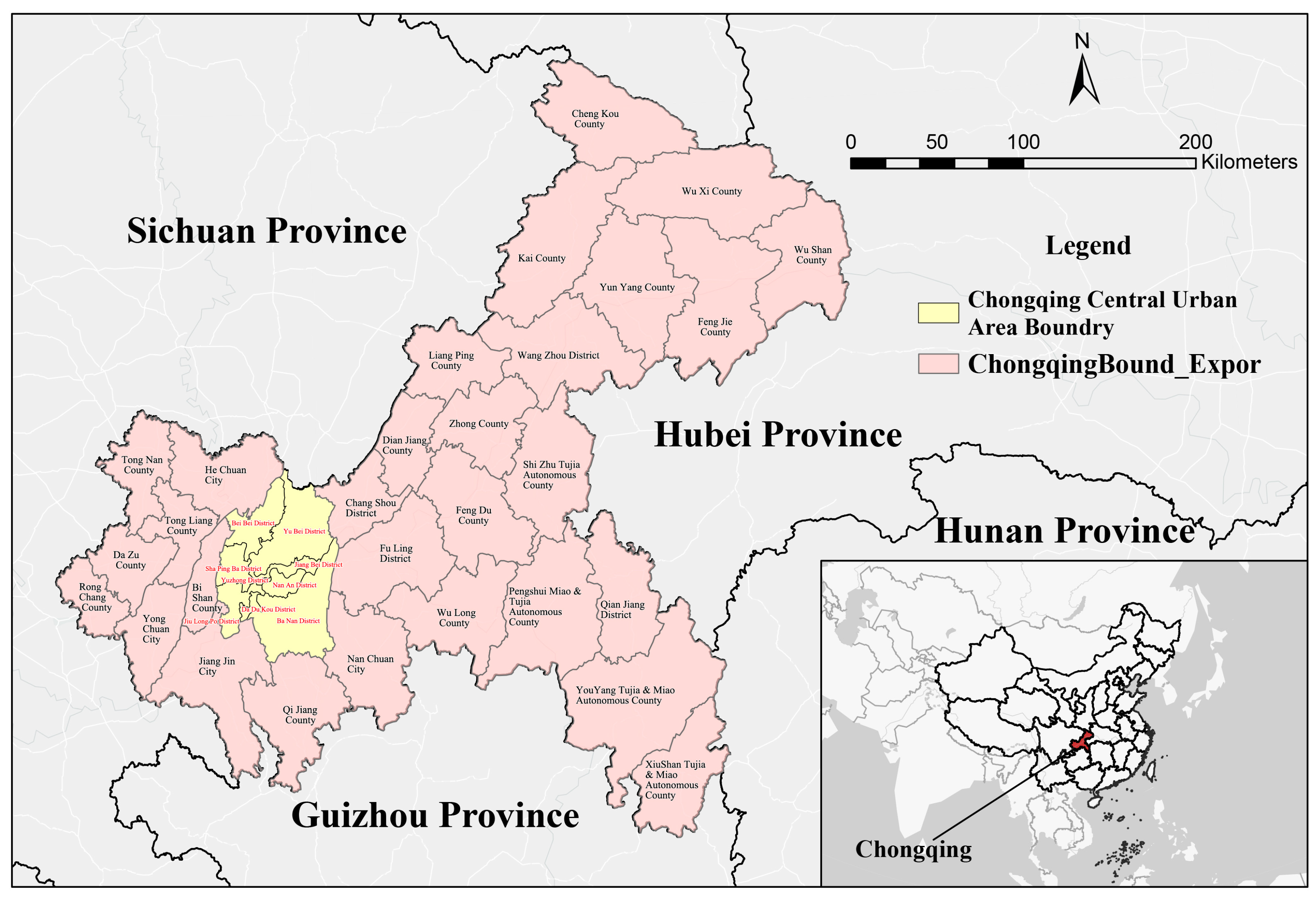
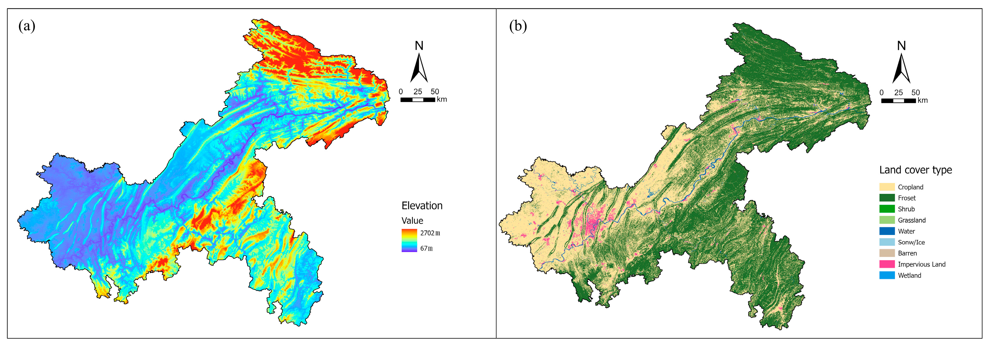
2.1. Study Area
2.2. Data
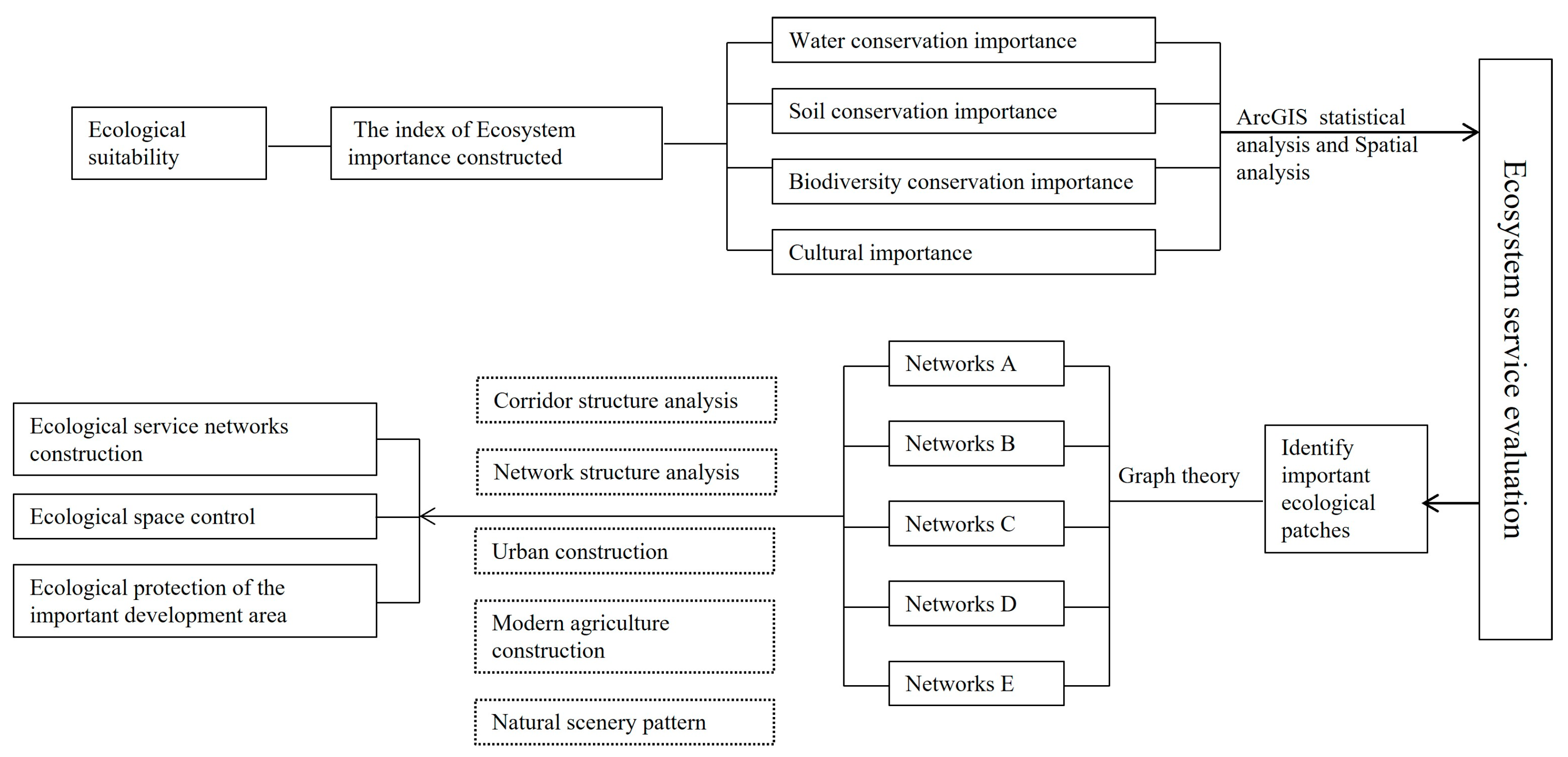
2.3. Methods
2.3.1. Ecological Suitability Analysis
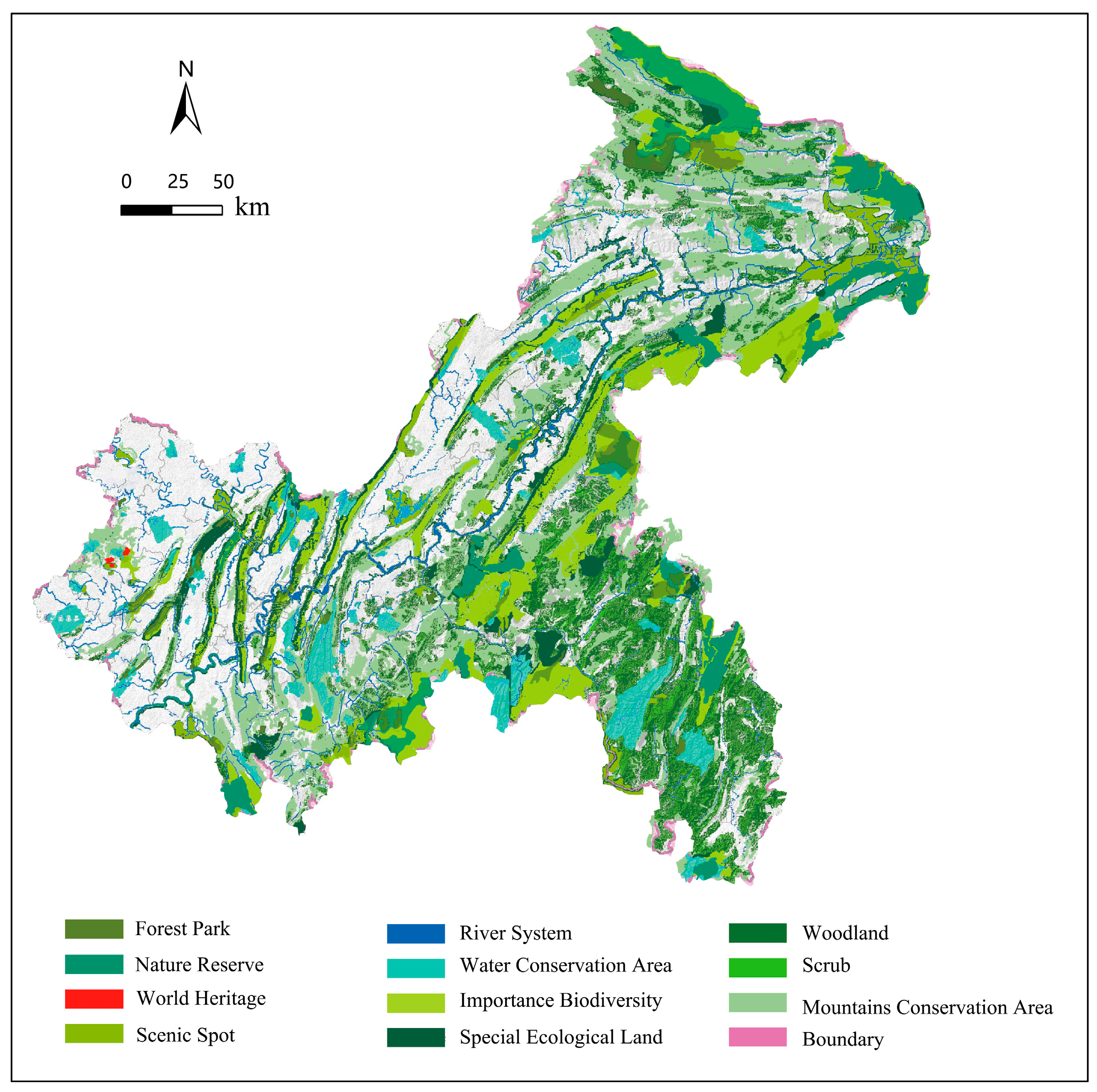
2.3.2. Ecosystem Services Importance Analysis
2.3.3. Identifying Ecological Source Areas
- EIF: Ecosystem importance;
- WF: Importance of water conservation;
- SF: Soil conservation importance;
- BF: Importance of biodiversity conservation;
- CF: Importance of cultural ecosystem.
2.3.4. Network Analysis
2.3.5. Ecological Networks Delineation
3. Results
3.1. Ecosystem Services Importance
3.2. Ecological Source Area
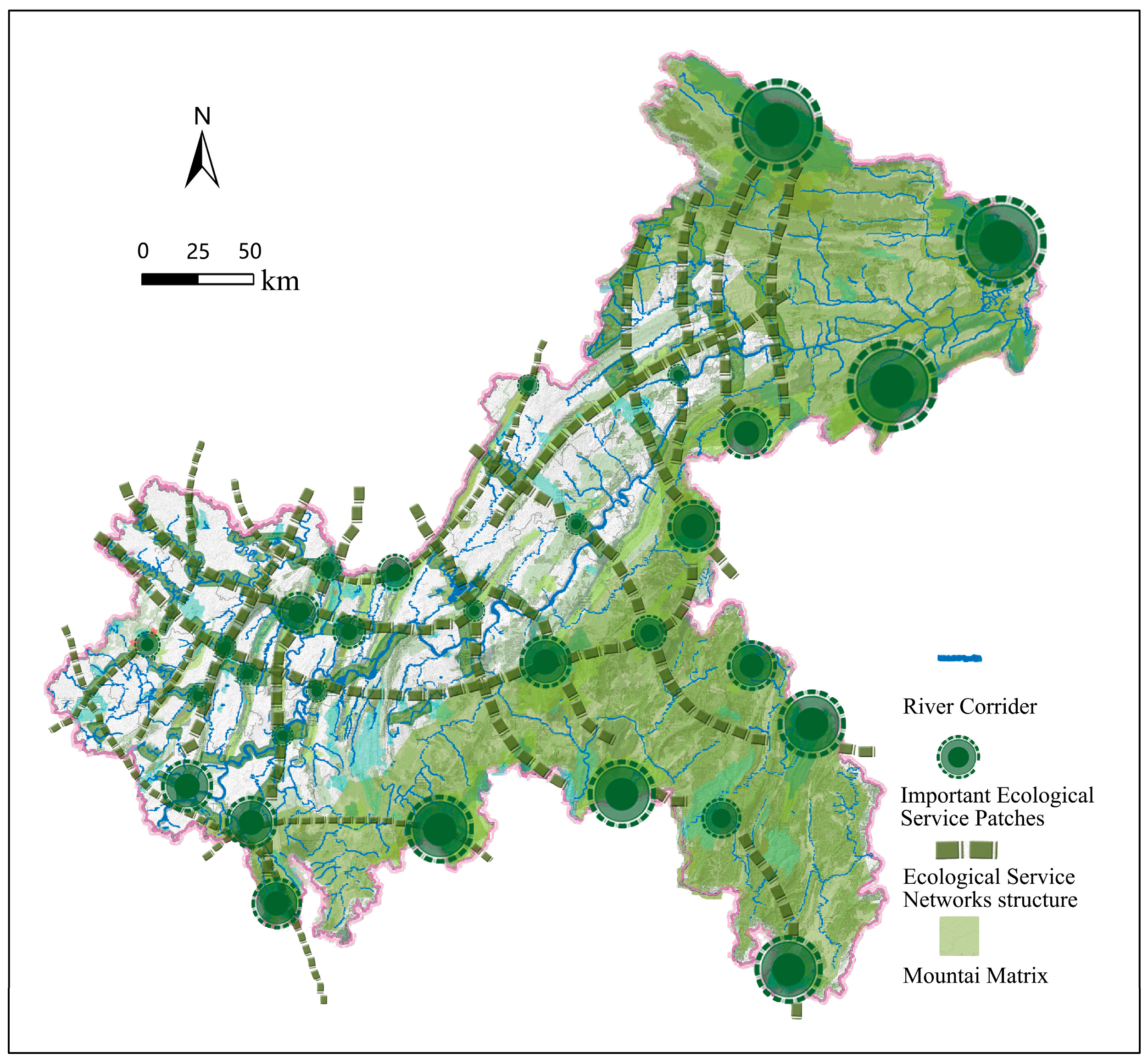
3.3. Network Delineation
3.4. Ecological Networks Analysis
4. Discussion
4.1. Advantages of Coupled Graph Theory and Network Analysis for Ecological Network Construction Based on Ecosystem Services
4.2. Identifying Effective Ecological Source Areas That Take into Account Ecological Suitability and Ecosystem Services Importance
4.3. Optimal Scenario for Ecological Networks Employing Graph Theory and Network Analysis
4.4. Ecological Network Planning Measure Suggestions
4.5. Limitations and Future Research
5. Conclusions
- (1)
- A total of 58 important ecological source areas were identified, with a total area of 5746 km2, accounting for 79.15% of the total foreground area. They mainly exhibited a distribution trend of higher values in the central and southeastern parts and lower values in the northwest. The land use types largely include water bodies and woodlands.
- (2)
- Using graph theory and network analysis methods, an optimal scenario was established, consisting of 5 horizontal corridors and 14 longitudinal corridors, connecting mountains, green spaces, water systems, and agricultural belts with high ecosystem services value.
- (3)
- A total of 5 crucial ecological function areas and key ecological zones in important urban development areas were identified. Control measures for these ecological lands were proposed to enhance the effectiveness of ecological service construction and ensure the ecological security functions of ecosystem services in Chongqing.
- (4)
- The results of the network structure analysis indicated that the constructed ecological network had strong integrity. This method has obvious applicability and reliability. This provides reliable ideas for constructing regional ecological security and building a bridge between the natural environment and human society in mountain regions.
Author Contributions
Funding
Data Availability Statement
Acknowledgments
Conflicts of Interest
References
- Grêt-Regamey, A.; Weibel, B. Global Assessment of Mountain Ecosystem Services Using Earth Observation Data. Ecosyst. Serv. 2020, 46, 101213. [Google Scholar] [CrossRef]
- Verburg, P.H.; Crossman, N.; Ellis, E.C.; Heinimann, A.; Hostert, P.; Mertz, O.; Nagendra, H.; Sikor, T.; Erb, K.-H.; Golubiewski, N.; et al. Land System Science and Sustainable Development of the Earth System: A Global Land Project Perspective. Anthropocene 2015, 12, 29–41. [Google Scholar] [CrossRef]
- Schirpke, U.; Wang, G.X.; Padoa-Schioppa, E. Editorial: Mountain Landscapes: Protected Areas, Ecosystem Services, and Future Challenges. Ecosyst. Serv. 2021, 49, 101302. [Google Scholar] [CrossRef]
- Li, J.Y.; Chen, X.; De Maeyer, P.; Van de Voorde, T.; Li, Y.M. Ecological Security Warning in Central Asia: Integrating Ecosystem Services Protection under SSPs-RCPs Scenarios. Sci. Total Environ. 2024, 912, 168698. [Google Scholar] [CrossRef]
- Mengist, W.; Soromessa, T.; Legese, G. Ecosystem Services Research in Mountainous Regions: A Systematic Literature Review on Current Knowledge and Research Gaps. Sci. Total Environ. 2020, 702, 134581. [Google Scholar] [CrossRef]
- Balthazar, V.; Vanacker, V.; Molina, A.; Lambin, E.F. Impacts of Forest Cover Change on Ecosystem Services in High Andean Mountains. Ecol. Indic. 2015, 48, 63–75. [Google Scholar] [CrossRef]
- Sun, D.L.; Yao, B.M.; Yang, G.; Sun, G.X. Climate and Soil Properties Regulate the Vertical Heterogeneity of Minor and Trace Elements in the Alpine Topsoil of the Hengduan Mountains. Sci. Total Environ. 2023, 899, 165653. [Google Scholar] [CrossRef]
- Wang, Y.H.; Dai, E.; Yin, L.; Ma, L. Land Use/Land Cover Change and the Effects on Ecosystem Services in the Hengduan Mountain Region, China. Ecosyst. Serv. 2018, 34, 55–67. [Google Scholar] [CrossRef]
- Guo, B.; Zang, W.Q.; Luo, W. Spatial-Temporal Shifts of Ecological Vulnerability of Karst Mountain Ecosystem-Impacts of Global Change and Anthropogenic Interference. Sci. Total Environ. 2020, 741, 140256. [Google Scholar] [CrossRef]
- Brunner, S.H.; Grêt-Regamey, A. Policy Strategies to Foster the Resilience of Mountain Social-Ecological Systems under Uncertain Global Change. Environ. Sci. Policy 2016, 66, 129–139. [Google Scholar] [CrossRef]
- Grêt-Regamey, A.; Huber, S.H.; Huber, R. Actors’ Diversity and the Resilience of Social-Ecological Systems to Global Change. Nat. Sustain. 2019, 2, 290–297. [Google Scholar] [CrossRef]
- Mitchell, M.G.E.; Suarez-Castro, A.F.; Martinez-Harms, M.; Maron, M.; McAlpine, C.; Gaston, K.J.; Johansen, K.; Rhodes, J.R. Reframing Landscape Fragmentation’s Effects on Ecosystem Services. Trends Ecol. Evol. 2015, 30, 190–198. [Google Scholar] [CrossRef] [PubMed]
- Schirpke, U.; Candiago, S.; Egarter Vigl, L.; Jäger, H.; Labadini, A.; Marsoner, T.; Meisch, C.; Tasser, E.; Tappeiner, U. Integrating Supply, Flow and Demand to Enhance the Understanding of Interactions among Multiple Ecosystem Services. Sci. Total Environ. 2019, 651, 928–941. [Google Scholar] [CrossRef] [PubMed]
- Durán, M.; Canals, R.M.; Sáez, J.L.; Ferrer, V.; Lera-López, F. Disruption of Traditional Land Use Regimes Causes an Economic Loss of Provisioning Services in High-Mountain Grasslands. Ecosyst. Serv. 2020, 46, 101200. [Google Scholar] [CrossRef]
- Ma, S.; Wang, L.J.; Zhu, D.Z.; Zhang, J.C. Spatiotemporal Changes in Ecosystem Services in the Conservation Priorities of the Southern Hill and Mountain Belt, China. Ecol. Indic. 2021, 122, 107225. [Google Scholar] [CrossRef]
- Qin, K.Y.; Li, J.; Liu, J.Y.; Yan, L.W.; Huang, H.J. Setting Conservation Priorities Based on Ecosystem Services—A Case Study of the Guanzhong-Tianshui Economic Region. Sci. Total Environ. 2019, 650, 3062–3074. [Google Scholar] [CrossRef] [PubMed]
- Pan, N.H.; Du, Q.Q.; Guan, Q.Y.; Tan, Z.; Sun, Y.F.; Wang, Q.Z. Ecological Security Assessment and Pattern Construction in Arid and Semi-Arid Areas: A Case Study of the Hexi Region, NW China. Ecol. Indic. 2022, 138, 108797. [Google Scholar] [CrossRef]
- Zhou, D.; Song, W. Identifying Ecological Corridors and Networks in Mountainous Areas. Int. J. Environ. Res. Public Health 2021, 18, 4797. [Google Scholar] [CrossRef]
- Gao, J.B.; Du, F.J.; Zuo, L.Y.; Jiang, Y. Integrating Ecosystem Services and Rocky Desertification into Identification of Karst Ecological Security Pattern. Landsc. Ecol. 2021, 36, 2113–2133. [Google Scholar] [CrossRef]
- Wang, C.; Liu, H. Developing Large-Scale International Ecological Networks Based on Least-Cost Path Analysis—A Case Study of Altai Mountains. Open Geosci. 2020, 12, 840–850. [Google Scholar] [CrossRef]
- Gao, J.; Gong, J.; Li, Y.; Yang, J.X.; Liang, X. Ecological Network Assessment in Dynamic Landscapes: Multi-Scenario Simulation and Conservation Priority Analysis. Land Use Policy 2024, 139, 107059. [Google Scholar] [CrossRef]
- An, L.; Shen, L.; Zhong, S.; Li, D. Transboundary Ecological Network Identification for Addressing Conservation Priorities and Landscape Ecological Risks: Insights from the Altai Mountains. Ecol. Indic. 2023, 156, 111159. [Google Scholar] [CrossRef]
- Wu, J.S.; Yue, X.X.; Qin, W. The Establishment of Ecological Security Patterns Based on the Redistribution of Ecosystem Service Value: A Case Study in the Liangjiang New Area, Chongqing. Geogr. Res. 2017, 36, 429–440. [Google Scholar] [CrossRef]
- Li, C.; Wu, Y.M.; Gao, B.P.; Zheng, K.J.; Wu, Y.; Wang, M.J. Construction of Ecological Security Pattern of National Ecological Barriers for Ecosystem Health Maintenance. Ecol. Indic. 2023, 146, 109801. [Google Scholar] [CrossRef]
- Jiang, H.; Peng, J.; Zhao, Y.; Xu, D.; Dong, J. Zoning for Ecosystem Restoration Based on Ecological Network in Mountainous Region. Ecol. Indic. 2022, 142, 109138. [Google Scholar] [CrossRef]
- Yang, C.; Guo, H.; Huang, X.; Wang, Y.; Li, X.; Cui, X. Ecological Network Construction of a National Park Based on MSPA and MCR Models: An Example of the Proposed National Parks of “Ailaoshan-Wuliangshan” in China. Land 2022, 11, 1913. [Google Scholar] [CrossRef]
- Lu, J.; Jiao, S.; Han, Z.W.; Yin, J.W. Promoting Ecological Restoration of Deeply Urbanized Hilly Areas: A Multi-Scale Ecological Networks Approach. Ecol. Indic. 2023, 154, 110655. [Google Scholar] [CrossRef]
- Linehan, J.; Gross, M.; Finn, J. Greenway Planning: Developing a Landscape Ecological Network Approach. Landsc. Urban Plan. 1995, 33, 179–193. [Google Scholar] [CrossRef]
- Xiao, H.; Guo, Y.; Wang, Y.; Xu, Y.; Liu, D. Evaluation and Construction of Regional Ecological Network Based on Multi-Objective Optimization: A Perspective of Mountains–Rivers–Forests–Farmlands–Lakes–Grasslands Life Community Concept in China. Appl. Sci. 2022, 12, 9600. [Google Scholar] [CrossRef]
- Wang, Z.C.; Shi, Z.Q.; Huo, J.G.; Zhu, W.B.; Yan, Y.H.; Ding, N. Construction and Optimization of an Ecological Network in Funiu Mountain Area Based on MSPA and MCR Models, China. Land 2023, 12, 1529. [Google Scholar] [CrossRef]
- Quintas-Soriano, C.; Martín-López, B.; Santos-Martín, F.; Loureiro, M.; Montes, C.; Benayas, J.; García-Llorente, M. Ecosystem Services Values in Spain: A Meta-Analysis. Environ. Sci. Policy 2016, 55, 186–195. [Google Scholar] [CrossRef]
- Martín-López, B.; Iniesta-Arandia, I.; García-Llorente, M.; Palomo, I.; Casado-Arzuaga, I.; Amo, D.G.D.; Gómez-Baggethun, E.; Oteros-Rozas, E.; Palacios-Agundez, I.; Willaarts, B.; et al. Uncovering Ecosystem Service Bundles through Social Preferences. PLoS ONE 2012, 7, e38970. [Google Scholar] [CrossRef] [PubMed]
- Alessa, L.; Kliskey, A.; Gosz, J.; Griffith, D.; Ziegler, A. MtnSEON and Social-Ecological Systems Science in Complex Mountain Landscapes. Front. Ecol. Environ. 2018, 16, S4–S10. [Google Scholar] [CrossRef]
- Bai, Y.J.; Guo, R. The Construction of Green Infrastructure Network in the Perspectives of Ecosystem Services and Ecological Sensitivity: The Case of Harbin, China. Glob. Ecol. Conserv. 2021, 27, e01534. [Google Scholar] [CrossRef]
- Xiong, S.G.; Qin, C.B.; Yu, L.; Lu, L.; Guan, Y.; Wan, J.; Li, X. Methods to Identify the Boundary of Ecological Space Based on Ecosystem Service Functions and Ecological Sensitivity: A Case Study of Nanning City. Acta Ecol. Sin. 2018, 38, 7899–7911. [Google Scholar] [CrossRef]
- Wang, L.R.; Deng, X.P.; Wang, C.; Mu, Z.B.; Li, Y.; He, D.J.; You, W.B.; Wu, L.Y. Ecological Space Planning Based on Ecosystem Services Importance and Ecological Sensitivity: A Case of Yongchun County, Fujian Province. Chin. J. Ecol. 2022, 41, 166–173. [Google Scholar] [CrossRef]
- Zhang, L.; Zhong, Q.C.; Zhang, R.; Zhang, G.L. Exploring the Conceptual Analysis and Construction Method of Urban Green Space Ecological Network. Landsc. Archit. 2024, 41, 4–10. [Google Scholar]
- Yin, H.; Kong, F. Lab Manual for Spatial Analysis in Urban and Rural Planning; Southeast University Press: Nanjing, China, 2014; ISBN 978-7-5641-6359-4. [Google Scholar]
- Yan, S.Y.; Yang, H.H.; Han, G.F. The Ecologically Planning Strategies in Chongqing Metropolitan. Chongqing Archit. 2011, 10, 7–10. [Google Scholar] [CrossRef]
- Yang, C.H.; Lei, B.; Li, J.; Zheng, L.; Liu, J.H.; Zhu, K.W. Evaluation Method of Eco-Environment Sensitivity in Chongqing. Ecol. Environ. Monit. Three Gorges 2017, 2, 19–27. [Google Scholar] [CrossRef]
- Yang, Y.Q.; Ren, P.; Hong, B.T. The Study of Land Use Conflict Based on Ecological Security of the Chongqing Section of Three Gores Reservoir Area. Resour. Environ. Yangtze Basin 2019, 28, 322–332. [Google Scholar]
- Liu, C.X.; Li, Y.C.; Yang, H.; Min, J.; Wang, C.J.; Zhang, H. RS and GIS-Based Assessment for Eco-Environmental Sensitivity of the Three Gorges Reservoir Area of Chongqing. Acta Geogr. Sin. 2011, 66, 631–642. [Google Scholar] [CrossRef]
- Li, G.X.; Song, M.Y.; Xie, L.F.; Xu, Y.C.; Tang, J.X.; Zhao, Y.W. Importance Evaluation of Soil and Water Conservation Function in Jiangsu Province. Bull. Soil Water Conserv. 2016, 36, 236–241. [Google Scholar] [CrossRef]
- Wang, F. Research on Ecosystem Services and Its Optimization in the Chongqing Main City. Ph.D. Thesis, Chongqing University, Chongqing, China, 2022. [Google Scholar]
- Sun, Y.H. The Slope Soil Water of Different Vegetation Types and Characteristics of Surface Runoff of Jinyun Mountain of Chongqing. Master’s Thesis, Beijing Forestry University, Beijing, China, 2007. [Google Scholar]
- Xiao, J.J.; Wu, K.; Zhang, L.Y.; Li, K.X.; Chen, Y.; Xie, G. Spatial Differentiation of Importance of Ecosystem Services in Karst Area of Yunnan-Guizhou Plateau. Bull. Soil Water Conserv. 2022, 42, 332–342. [Google Scholar] [CrossRef]
- Rands, M.R.W.; Adams, W.M.; Bennun, L.; Butchart, S.H.M.; Clements, A.; Coomes, D.; Entwistle, A.; Hodge, I.; Kapos, V.; Scharlemann, J.P.W.; et al. Biodiversity Conservation: Challenges beyond 2010. Science 2010, 329, 1298–1303. [Google Scholar] [CrossRef] [PubMed]
- Fang, Y.S.; Zu, J.; Ai, D.; Chen, J.; Liang, Q.Y. Research on Evaluation of the Importance of Ecological Protection in Kunming City Oriented to Spatial Planning. J. China Agric. Univ. 2021, 26, 152–163. [Google Scholar] [CrossRef]
- Scholte, S.; van Teeffelen, A.; Verburg, P. Integrating Socio-Cultural Perspectives into Ecosystem Service Valuation: A Review of Concepts and Methods. Ecol. Econ. 2015, 114, 67–78. [Google Scholar] [CrossRef]
- Han, X. Ecosystem Assessment and Ecological Function Regionalization of Qingdao City. Ph.D. Thesis, Donghua University, Shanghai, China, 2008. [Google Scholar]
- Weber, T.; Sloan, A.; Wolf, J. Maryland’s Green Infrastructure Assessment: Development of a Comprehensive Approach to Land Conservation. Landsc. Urban Plan. 2006, 77, 94–110. [Google Scholar] [CrossRef]
- Zong, M. A Study of Urban Green Infrastructure Network Construction and Planning Pattern. Shanghai Urban Plan 2015, 3, 104–109. [Google Scholar]
- Zhang, L.Q.; Wang, H.Z. Planning an Ecological Network of Xiamen Island (China) Using Landscape Metrics and Network Analysis. Landsc. Urban Plan. 2006, 78, 449–456. [Google Scholar] [CrossRef]
- Bunn, A.G.; Urban, D.L.; Keitt, T.H. Landscape Connectivity: A Conservation Application of Graph Theory. J. Environ. Manag. 2000, 59, 265–278. [Google Scholar] [CrossRef]
- Hellmund, P. Quabbin to Wachusett Wildlife Corridor Study; Harvard Graduate School of Design: Cambridge, MA, USA, 1989. [Google Scholar]
- Xu, X.L.; Wang, S.Y.; Rong, W.Z. Construction of Ecological Network in Suzhou Based on the PLUS and MSPA Models. Ecol. Indic. 2023, 154, 110740. [Google Scholar] [CrossRef]
- Forman, R.T.T.; Godorn, M. Landscape Ecology; Wiley: New York, NY, USA, 1986; ISBN 978-0-471-87037-1. [Google Scholar]
- Forman, R.T.T. Urban Ecology: Science of Cities; Cambridge University Press: Cambridge, UK, 2014; ISBN 978-1-107-00700-0. [Google Scholar]
- Zhu, L.C.; Wang, H.W.; Tang, L.N. Importance Evaluation and Spatial Distribution Analysis of Ecosystem Services in Min Triangle Area. Acta Ecol. Sin. 2018, 38, 7254–7268. [Google Scholar] [CrossRef]
- Febrianto, H.; Fariza, A.; Nur Hasim, J.A. Urban Flood Risk Mapping Using Analytic Hierarchy Process and Natural Break Classification (Case Study: Surabaya, East Java, Indonesia). In Proceedings of the 2016 International Conference on Knowledge Creation and Intelligent Computing (KCIC), Manado, Indonesia, 15–17 November 2016; pp. 148–154. [Google Scholar]
- Lv, L.; Zhang, S.H.; Zhu, J.; Wang, Z.M.; Wang, Z.; Li, G.Q.; Yang, C. Ecological Restoration Strategies for Mountainous Cities Based on Ecological Security Patterns and Circuit Theory: A Case of Central Urban Areas in Chongqing, China. Int. J. Environ. Res. Public Health 2022, 19, 16505. [Google Scholar] [CrossRef] [PubMed]
- Adrienne, G.R.; Sibyl, H.B.; Felix, K. Mountain Ecosystem Services: Who Cares? Mt. Res. Dev. 2012, 32, S1. [Google Scholar] [CrossRef]
- Zhao, S.M.; Ma, Y.F.; Wang, J.L.; You, X.Y. Landscape Pattern Analysis and Ecological Network Planning of Tianjin City. Urban For. Urban Green. 2019, 46, 126479. [Google Scholar] [CrossRef]
- Vlková, K.; Zýka, V.; Papp, C.R.; Romportl, D. An Ecological Network for Large Carnivores as a Key Tool for Protecting Landscape Connectivity in the Carpathians. J. Maps 2024, 20, 2290858. [Google Scholar] [CrossRef]
- Sherrouse, B.C.; Clement, J.M.; Semmens, D.J. A GIS Application for Assessing, Mapping, and Quantifying the Social Values of Ecosystem Services. Appl. Geogr. 2011, 31, 748–760. [Google Scholar] [CrossRef]
- Zahidi, I.; Yau, M.; Lechner, A.; Lourdes, K. Modelling Public Social Values of Flood-Prone Land Use Using the GIS Application SolVES. J. Hydroinform. 2023, 26, 20–32. [Google Scholar] [CrossRef]
- Shrestha, K.; Shakya, B.; Adhikari, B.; Nepal, M.; Shaoliang, Y. Ecosystem Services Valuation for Conservation and Development Decisions: A Review of Valuation Studies and Tools in the Far Eastern Himalaya. Ecosyst. Serv. 2023, 61, 101526. [Google Scholar] [CrossRef]
- Li, Y.C.; Liu, C.X.; Min, J.; Wang, C.J.; Zhang, H.; Wang, Y. RS/GIS-Based Integrated Evaluation of the Ecosystem Services of the Three Gorges Reservoir Area (Chongqing Section). Acta Ecol. Sin. 2013, 33, 168–178. [Google Scholar] [CrossRef]
- Battisti, C. Ecological Networks as Planning Tools for African Fragmented Landscapes: Overcoming Weaknesses for an Effective Connectivity Conservation. Afr. J. Ecol. 2024, 62, e13186. [Google Scholar] [CrossRef]
- Pennington, D.; Ricketts, T.; Naidoo, R. Priority Setting for Biodiversity and Ecosystem Services. In Encyclopedia of Biodiversity, 2nd ed.; Levin, S.A., Ed.; Academic Press: Waltham, MA, USA, 2013; pp. 261–272. ISBN 978-0-12-384720-1. [Google Scholar]
- Polasky, S.; Nelson, E.; Pennington, D.; Johnson, K.A. The Impact of Land-Use Change on Ecosystem Services, Biodiversity and Returns to Landowners: A Case Study in the State of Minnesota. Environ. Resour. Econ. 2011, 48, 219–242. [Google Scholar] [CrossRef]
- Deng, W.; Liu, H.; Li, S.L.; Yuan, X.Z.; Zhang, Y.W.; Li, B.; Qi, J. Dynamic Changes of Ecosystem Services of Key Ecological Function Areas in Chongqing, China. Res. Environ. Sci. 2015, 28, 250–258. [Google Scholar] [CrossRef]
- Li, H.; Wang, F.H.; Luo, Y.C. Research on the Essential Evaluation and Mechanism of “One Circle, Two Groups” Ecosystem Services in Chongqing Based on NPP Quantitative Index Evaluation Method. Ecol. Sci. 2021, 40, 64–73. [Google Scholar] [CrossRef]
- Loreau, M.; Mouquet, N.; Holt, R. Meta-Ecosystems: A Theoretical Framework for a Spatial Ecosystem Ecology. Ecol. Lett. 2003, 6, 673–679. [Google Scholar] [CrossRef]
- Cid, N.; Erős, T.; Heino, J.; Singer, G.; Jähnig, S.C.; Cañedo-Argüelles, M.; Bonada, N.; Sarremejane, R.; Mykrä, H.; Sandin, L.; et al. From Meta-System Theory to the Sustainable Management of Rivers in the Anthropocene. Front. Ecol. Environ. 2022, 20, 49–57. [Google Scholar] [CrossRef]
- Ortega, U.; Ametzaga-Arregi, I.; Sertutxa, U.; Pena, L. Identifying a Green Infrastructure to Prioritise Areas for Restoration to Enhance the Landscape Connectivity and the Provision of Ecosystem Services. Landsc. Ecol. 2023, 38, 3751–3765. [Google Scholar] [CrossRef]


| Data | Subdata | Year (s) | Spatial Resolution | Sources |
|---|---|---|---|---|
| Land use data | Land use | 2020 | 30 m | https://earthexplorer.usgs.gov, accessed on 3 January 2020. |
| Environmental data | DEM, slope, geological disaster | 2020 | 30 m | https://earthexplorer.usgs.gov, accessed on 3 January 2020. |
| Ecological functional land data | Nature Reserves, Forest Parks, Cultural Heritage Sites and Scenic Spots, Wetlands | 2020 | 30 m | Chongqing Environmental Protection Bureau, Chongqing Forestry Bureau |
| NVDI data | Vegetation data | 2020 | 30 m | Chongqing Forestry Bureau |
| Forest Resources Category II | 2020 | 30 m | Chongqing Forestry Bureau | |
| Water bodies data | Rivers, lakes, and water sources | 2020 | 30 m | Chongqing Water Resources Bureau |
| Biodiversity data | National protected animals and plants and endangered animals and plants | 2020 | 30 m | Chongqing Environmental Protection Bureau |
| Soil erosion data | Soil erosion | 2020 | 30 m | Chongqing Water Resources Bureau |
| Ecological Factors | Classification | Evaluation Value | Weight |
|---|---|---|---|
| Slope | >48% | 2 | 0.15 |
| 25~48% | 1 | ||
| <25% | 0 | ||
| Altitude above sea level | <196 m | 0 | 0.10 |
| >500 m | 1 | ||
| 196~500 m | 2 | ||
| Lithological character | \ 1 | 2 | 0.10 |
| Carbonate reservoir | 1 | ||
| Argillaceous and sandstone | 0 | ||
| Geological disaster | Geological disaster spots or subsided areas, which are weighty disasters | 2 | 0.15 |
| Active zone and potentially active zone, | 1 | ||
| Non-active zone | 0 | ||
| Forest and green space | Urban forest space | 2 | 0.10 |
| Urban green space | 1 | ||
| The area which is not forest or green space | 0 | ||
| Wetland | 500 m around medium reservoir | 2 | 0.10 |
| Converge area of reservoir and water source, wetland isolation paddy field | 1 | ||
| Non-water source area | 0 | ||
| Nature Reserves, Scenic Spots, Forest Park | National and Municipal Nature Reserves, Forest Parks, Cultural Heritage Sites, and Scenic Spots | 2 | 0.12 |
| \ | 1 | ||
| The area does not have a Nature Reserve, Forest Park, or Scenic Spot | 0 | ||
| Enclave-Nature and Cultural Reserves | \ | 2 | 0.18 |
| Enclave—Nature and Cultural Reserve | 1 | ||
| Non-Nature, Enclave—Cultural Reserve | 0 |
| Affected Targets | Types and Areas of Influence | Classification | |
|---|---|---|---|
| River | The hydro-fluctuation-belt of the Three Gorges Reservoir of the main river (urban water sources, flood regulation) | 1 km on both sides of the river | Extremely important |
| 2 km on both sides of the river | Strongly important | ||
| 3 km on both sides of the river | Moderately important | ||
| Second-order stream (water sources, flood regulation) | 200 m on both sides of the river | Extremely important | |
| 400 m on both sides of the river | Strongly important | ||
| 600 m on both sides of the river | Moderately important | ||
| Lake, reservoir, water source protection area | Extremely important | ||
| Forest | Water conservation forest (water sources) | Evergreen and deciduous broad-leaved mixed forest, evergreen coniferous forest, evergreen broadleaved forest, mixed evergreen coniferous broad-leaved forest | Extremely important |
| Deciduous broad-leaved forest, economic trees, mixed broadleaf—conifer forest | Strongly important | ||
| Brush | Moderately important | ||
| Agricultural and other areas | Slightly important | ||
| Affected Water Body | Sensitivity of Soil Erosion | ||||
|---|---|---|---|---|---|
| Insensitive | Slightly Sensitive | Moderately Sensitive | Strongly Sensitive | Extremely Sensitive | |
| The 1st- and 2nd-order rivers; The drinking water bodies of large and medium-sized cities | Slightly important | Strongly important | Extremely important | Extremely important | Extremely important |
| The 3rd-order rivers; The drinking water bodies of the towns | Slightly important | Moderately important | Strongly important | Strongly important | Extremely important |
| The 4th- and 5th-order rivers | Slightly important | Slightly important | Moderately important | Strongly important | Strongly important |
| Classification | Ecological Regions |
|---|---|
| Extremely important | The area of the first-class nationally protected animals and plants and endangered animals and plants. National Nature Reserves, Forest Parks, and Scenic Spots |
| Strongly important | The area of the second-class nationally protected animals and plants and endangered animals and plants. Provincial Nature Reserves, Forest Parks, and Scenic Spots. ‘Four Mountains’ Nature Reserve 1 |
| Moderately important | The area of other nationally and provincially protected animals and plants. County Nature Reserves, Forest Parks, and Scenic Spots |
| Slightly important | Other areas |
| Ecological Regions | Classification |
|---|---|
| National Nature Reserves, Forest Parks, and Scenic Spots | Extremely important |
| Special significance national conservative heritage unit. Municipal Nature Reserves, Forest Parks, and Scenic Spots | Strong important |
| Historical significance municipal conservative heritage units | Moderately important |
| Historical significance district Scenic Spots and district conservative heritage units | Slightly important |
| Index Type | Calculation Method | Index Meaning |
|---|---|---|
| α index | α = (L − V + 1)/(2V − 5) | The network circuitry (α) is a degree which loops within a network. The α index ranges from 0 for no loops in the network to 1.0 for the maximum number of loops in the network [57]. |
| β index | β = L/V | A network’s node/line ratio (β ≤ 1) presents a dendroid pattern. β = 1, the network presents a single loop. β > 1, the network presents more complex connectivity [57]. |
| γ index | γ = L/3(V − 2) | The network connectivity (γ) index ranges from 0, representing no linking nodes, to 1.0, meaning all nodes are connected [57]. |
| Cost ratio | Cr = 1 − (numbers of corridors/length of corridors) | Measure different green spaces and network cost differences regarding the socio-economic realities and landscape environment [57]. |
| Network | Corridor Number | Corridor Length(km) | Corridor Density (km × km−2) |
|---|---|---|---|
| A | 21 | 1192.59 | 0.01447 |
| B | 58 | 2117.88 | 0.2570 |
| C | 60 | 2246.37 | 0.02726 |
| D | 74 | 3238.97 | 0.03930 |
| E | 74 | 3300.42 | 0.04010 |
| Network | Node | Corridor | α Index | β Index | γ Index | Cost Ratio |
|---|---|---|---|---|---|---|
| A | 58 | 21 | 0 | 0.36 | 0.125 | 0.9824 |
| B | 58 | 58 | 0.00 | 1 | 0.345 | 0.6726 |
| C | 58 | 60 | 0.03 | 1.03 | 0.357 | 0.8733 |
| D | 58 | 74 | 0.15 | 1.26 | 0.44 | 0.8772 |
| E | 58 | 74 | 0.15 | 1.26 | 0.44 | 0.9776 |
| Serial Number | Name of the Important Ecological Functional Region | The Dominant Eco-Function | ||||
|---|---|---|---|---|---|---|
| Water Conservation | Soil Conservation | Biodiversity Conservation | Water Quality Safety | Flood Regulation | ||
| 1 | Three Gorges Reservoir: Important water conservation area | ++ | + | ++ | ++ | ++ |
| 2 | Qinba Mountain: Important water conservation area | ++ | + | ++ | ||
| 3 | Wuling Mountain: Important biodiversity conservation area | ++ | ++ | ++ | ||
| 4 | Jinfo Mountain: Important biodiversity conservation area | ++ | + | ++ | ||
| 5 | ‘Four Mountains’ in urban area: Important ecological protective screen | ++ | + | + | ++ | |
Disclaimer/Publisher’s Note: The statements, opinions and data contained in all publications are solely those of the individual author(s) and contributor(s) and not of MDPI and/or the editor(s). MDPI and/or the editor(s) disclaim responsibility for any injury to people or property resulting from any ideas, methods, instructions or products referred to in the content. |
© 2024 by the authors. Licensee MDPI, Basel, Switzerland. This article is an open access article distributed under the terms and conditions of the Creative Commons Attribution (CC BY) license (https://creativecommons.org/licenses/by/4.0/).
Share and Cite
Yang, H.; Yan, S.; Wang, X.; Li, C.; Meng, H.; Yao, Q. Constructing Ecological Networks Based on Ecosystem Services and Network Analysis in Chongqing, China. Land 2024, 13, 662. https://doi.org/10.3390/land13050662
Yang H, Yan S, Wang X, Li C, Meng H, Yao Q. Constructing Ecological Networks Based on Ecosystem Services and Network Analysis in Chongqing, China. Land. 2024; 13(5):662. https://doi.org/10.3390/land13050662
Chicago/Turabian StyleYang, Huihui, Shuiyu Yan, Xinhao Wang, Chun Li, Haixing Meng, and Qiang Yao. 2024. "Constructing Ecological Networks Based on Ecosystem Services and Network Analysis in Chongqing, China" Land 13, no. 5: 662. https://doi.org/10.3390/land13050662
APA StyleYang, H., Yan, S., Wang, X., Li, C., Meng, H., & Yao, Q. (2024). Constructing Ecological Networks Based on Ecosystem Services and Network Analysis in Chongqing, China. Land, 13(5), 662. https://doi.org/10.3390/land13050662