Abstract
Understanding groundwater–surface water interaction is essential for water resource management and watershed ecological protection. However, the existing studies often emphasize the tracer role of hydrogeochemical methods (including hydrochemistry and isotopes) while underestimating the importance of analyzing watershed hydraulic characteristics, thus neglecting the indications of the driving mechanisms (hydraulic head difference) for the water exchange. Taking the Songhua River in the Sanjiang Plain as an example, this study combines hydraulic, hydrochemical, and isotopic methods to clarify the groundwater–surface water interactions from both a driving mechanism perspective and a hydrogeochemical characterization perspective within the water cycle. The results indicate that human exploitation has caused river water to infiltrate into groundwater, converting the section into a losing river, where surface water consistently exhibits a hydraulic tendency to recharge the aquifer. The influence zone of the river extends up to 3.5 km from the riverbank, with an average recharge rate from the river reaching 78.04% within this area. This recharge mixes and dilutes the adjacent groundwater, impacting its hydrogeochemical characteristics. This study enhances the understanding of combined methods for groundwater–surface water interaction and provides a scientific basis for water resource management and pollution control strategies in the local agricultural regions.
1. Introduction
Surface water and groundwater are interconnected within the hydrological cycle, with interactions occurring in terms of water quantity, quality, and biogeochemistry [1]. These interactions are crucial for the formation and evolution of water resources [2] and play an essential role in water resource assessment [3], ecosystem conservation [4], pollution control [5], drinking water safety [6], and even global environmental issues such as greenhouse gas emissions [7,8].
The groundwater–surface water interaction exhibits complex spatiotemporal variability [9,10], and conventional hydrological and groundwater monitoring systems often lack sufficient coverage to fully capture these dynamics, making it extremely challenging to accurately characterize the interaction patterns in specific regions. To address this issue, a range of methods has been employed [11], including direct measurements [12,13], thermal tracers [14,15], water balance [16,17], and numerical modeling [18,19]. Among these, hydrochemical and isotopic characteristics, as geochemical markers of the water cycle, are effective tools for tracing water interactions and have become mainstream methods [20,21,22]. For instance, Wang et al. [23] investigated the spatiotemporal variability of interactions between the Yiluo River and the groundwater on a watershed scale using hydrochemical and isotopic methods. Similarly, Yang et al. [24] identified the interactions between the surface water and the groundwater in the arid region of Delingha through hydrochemical and isotopic characteristics, with many other studies following similar approaches [25,26,27,28]. However, due to the complex and variable hydrogeochemical reactions and isotopic fractionation effects, the interactions derived from hydrogeochemical methods remain uncertain and are generally qualitative or semi-quantitative [29,30]. The primary driver of groundwater–surface water interaction is the hydraulic head differences between the two systems within the water cycle. Therefore, analyzing the hydraulic differences can determine the interactions from the driving mechanism perspective [31] and should be prioritized [32]. Nonetheless, the existing studies have rarely systematically analyzed the hydraulic characteristics of these interactions [33], especially for regions distant from riverbanks. Combining hydraulic and hydrogeochemical characteristics for a comprehensive analysis from both a driving mechanism perspective and a hydrogeochemical characterization perspective of the water cycle can better avoid distorted conclusions.
In the rapidly expanding agricultural region of the Sanjiang Plain, the dynamic balance between the Songhua River and the groundwater has undergone significant changes following land reclamation [34,35,36]. As early as 1994, it was confirmed that certain sections of the Songhua River had altered the direction of interactions due to riparian groundwater extraction [37]. With the gradual expansion of farmland, there remains no consensus on the current evolution of natural interactions. Both Wang et al. [38] and Zhang et al. [39] conducted regional-scale studies on the groundwater–surface water interactions in the Sanjiang Plain, but their conclusions differed, and the regional scale was too broad to provide precise insights for smaller river segments. Jia et al. [40] quantitatively assessed the groundwater–surface water interactions of the Songhua and Naoli Rivers in the Sanjiang Plain using multivariate statistical and hydrochemical data, but their study focused only on the dry season. The interactions between the Songhua River and the groundwater are complex, and the evolution of natural interactions under human intervention remains unclear. Therefore, it is necessary to systematically combine hydraulic and hydrogeochemical evidence in order to provide an updated and unified understanding of the interactions between the Songhua River and the groundwater.
Taking the Songhua River in the Sanjiang Plain as an example, this study systematically clarifies groundwater–surface water interaction characteristics by combining hydraulic, hydrochemical, and isotopic methods from both a driving mechanism perspective and a hydrogeochemical characterization perspective within the water cycle. This study enhances the understanding of combined methods for groundwater–surface water interaction and provides a scientific basis for water resource management and pollution control strategies in local agricultural regions.
2. Materials and Methods
2.1. Study Area
The study area is located in the eastern part of Heilongjiang Province, China, and is part of the Sanjiang Plain (Figure 1), covering approximately 13,300 km2. The terrain is low-lying, with elevations ranging from 42 to 539 m, sloping gradually from southwest to northeast, with large tracts of farmland concentrated in the northeast. The main channel of the Songhua River flows from southwest to northeast through the study area, with a width ranging from 0.5 to 2 km and an annual runoff of 7.27 × 10⁸ m3. The riverbanks, composed of alluvial plains, are flat and open, with wide channels and floodplains featuring numerous shallow streams. The Songhua River flows into the Heilong River northeast of Tongjiang City, with major tributaries including the Dulu River, Wutong River, Heli River, and Anbang River. The area experiences a continental monsoon climate with abundant rainfall, generally between 450 and 650 mm annually, about 70% of which occurs between June and September. The long-term average temperature is approximately 3 to 5 °C [40].
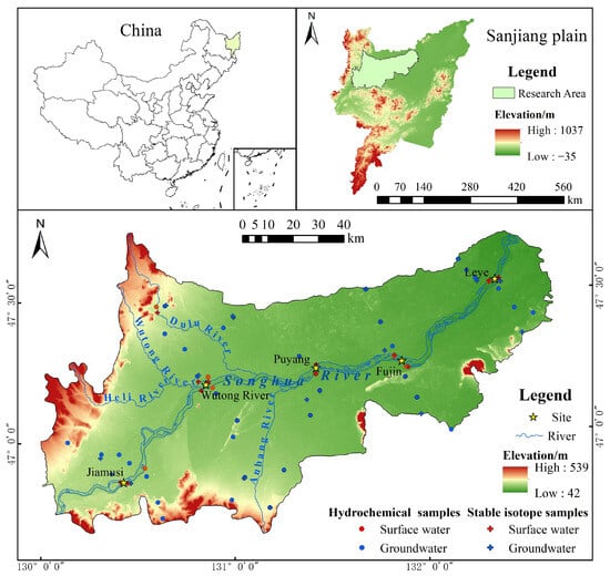
Figure 1.
The location of the study area and distribution of collected water samples.
The shallow groundwater in the study area’s plain is primarily found in the Quaternary unconfined aquifers with pore structures and the Tertiary confined aquifers featuring pore and fracture systems [36,41]. The general flow direction of the groundwater is from southwest to northeast. Due to the gentle slope of the terrain, the runoff rate is relatively slow, although it is more pronounced near the rivers. The surface clay layer in the study area is relatively thin, with no cohesive soil cover in the low floodplain regions. Groundwater recharge predominantly results from the infiltration of atmospheric precipitation and irrigation, with additional recharge potentially occurring from adjacent rivers. The primary discharge mechanisms include artificial extraction, evaporation, and lateral runoff.
2.2. Data Collection and Sampling Analysis
This study integrates hydraulic, hydrochemical, and isotopic analyses to achieve its objectives, utilizing data that include both hydraulic and hydrogeochemical measurements. Water quality samples were collected from the Songhua River and groundwater in September 2020, and the water samples for stable isotopes (deuterium (D) and oxygen-18 (18O)) were collected in September 2023. The hydrochemical dataset includes 43 samples (9 surface water and 34 groundwater), while the isotope dataset includes 39 samples (12 surface water and 27 groundwater). Three rainfall samples were also collected in September 2023 for stable isotope testing near Jiamusi, Puyang, and Fujin. The sampling profiles were oriented both parallel and perpendicular to the flow directions of the groundwater and river water (Figure 1). This approach helps to explore the interactions between the surface water and groundwater. The annual water levels observed in 2020 were collected from three hydrological stations (Jiamusi Station, Fujin Station, and Tongjiang Station) along the Songhua River and from 98 groundwater monitoring wells across the study area (Figure 3). These data represent the most current and comprehensive hydraulic data available and were provided by Heilongjiang Provincial Water Conservancy and Hydroelectric Power Investigation, Design, and Research Institute.
For sample collection and preservation, we followed the “Technical Specification for Groundwater Environmental Monitoring” (China, HJ/T 164-2004). Surface water samples were collected from 30 cm below the river surface, and groundwater samples were obtained after 10 min of pumping. The on-site measurements of temperature, pH, electrical conductivity (EC), redox potential (Eh), and dissolved oxygen (DO) were conducted using a portable analyzer (Hach HQ40d, Loveland, Hach Co., CO., USA). The sampling bottles were first rinsed with distilled water, then three times with the environmental sample, before being sealed, labeled, and marked. After collection, the samples were stored below 4 °C and promptly transported to the laboratory. All samples were filtered through a 0.45 μm filter before analysis. The water quality analyses included Total Dissolved Solids (TDS) and concentrations of ions such as K+, Ca2+, Mg2+, Na+, NH4+, HCO3−, CO32−, SO42−, Cl−, F−, NO2−, and NO3−. Data reliability was assessed using Charge-Balance Error (CBE), with data being excluded if CBE exceeded 10%. Stable isotopes (δ18O (‰) and δD (‰)) were analyzed using a water vapor isotope analyzer (Picarro L2120-I, Picarro Inc., Santa Clara, CA, USA), with results compared to Vienna Standard Mean Ocean Water (V-SMOW) and reported as δ-values. The measurement accuracy for δ18O and δD is ±0.1‰ and ±0.5‰, respectively.
2.3. Hydraulic Analysis
The interaction between surface water and groundwater systems is fundamentally driven by differences in water levels. Therefore, in studying these interactions, it is essential to prioritize the analysis of flow field dynamics on a regional scale. Diagrams were initially plotted to depict the hydraulic differences between the river and the adjacent groundwater at various locations and times, both in cross-sections and planar views, to analyze the interactions and their temporal and spatial variations.
Figure 2 illustrates the contour characteristics of groundwater–surface water interactions, based on the data from hydrological stations and groundwater monitoring networks. In Figure 2a, the contour lines indicate groundwater discharging to surface water, with “V” shapes pointing upstream. Figure 2b shows surface water recharging groundwater, where “V” shapes point downstream. By prioritizing similar hydraulic analyses within the study area, a preliminary understanding of the interactions between the Songhua River and groundwater can be achieved, thereby providing crucial hydraulic evidence.
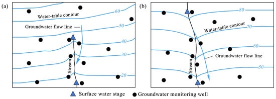
Figure 2.
Schematic diagram of the contour characteristics of groundwater–surface water interactions [31], where (a) represents gaining river and (b) represents losing river.
2.4. Hydrogeochemical Analysis
Hydrogeochemical characteristics reflect the geochemical markers of water cycles. Analyzing these characteristics is an effective method for tracing the interactions between surface water and groundwater [1,42]. Initially, a statistical analysis of all hydrochemical and isotope data was conducted to provide a clear and systematic overview, where the coefficient of variation (COV) was applied to quantify the dispersion of various indicators, calculated as the ratio of the standard deviation (σ) to the mean (μ), as follows:
Subsequently, the regional distribution of TDS was mapped, and Piper trilinear and Gibbs diagrams were plotted to investigate the spatial characteristics, composition, and dominant causes of the water chemistry in the study area [43,44]. Additionally, the composition and distribution of stable isotopes of deuterium (D) and oxygen-18 (18O) in various samples were analyzed to determine the recharge sources and hydraulic connections among the water bodies [45]. These analyses strengthen the evidence for the interaction between surface water and groundwater in the Songhua River Basin and support the conclusions drawn from hydraulic analysis.
2.5. Calculation of Recharge Ratios
Stable isotope analysis of deuterium (D) and oxygen-18 (18O) is useful for tracing the recharge ratios of different water sources. When groundwater is a mixture of sources A and B, the formula to calculate the proportion of recharge from source A, based on isotope mass balance, is as follows [23]:
Here, Rg denotes the proportion of groundwater recharge from source A, δA represents the isotope value of source A, δg is the isotope value of the groundwater, and δB is the isotope value of source B. After calculating the recharge proportion from source A, the remaining proportion is attributed to recharge from source B.
3. Results and Discussion
3.1. Hydraulic Analysis
3.1.1. Hydraulic Characteristics of Observation Cross-Sections
Initially, typical cross-sections were selected based on the distribution and number of hydrological stations and nearby groundwater monitoring wells to analyze spatial variations in water level differences. To account for the spatial variability in groundwater–surface water interactions, five cross-sections were established along the upstream, downstream, and both banks of the Songhua River (Table 1, Figure 3).

Table 1.
Hydraulic observation cross-sections.
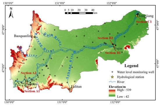
Figure 3.
Distribution of groundwater level monitoring wells and observation cross-sections.
Water levels can fluctuate significantly within a few days due to weather changes and human activities. These short-term fluctuations can disrupt the assessment of water level differences, complicating the identification of interaction relationships. Additionally, groundwater–surface water interactions are not typically assessed on short time scales such as daily or monthly intervals. To mitigate these fluctuations and ensure an accurate representation of water level variations, the monthly average water levels of surface water and groundwater in 2020 were used to plot the water level process lines for each observation cross-section (Figure 4).
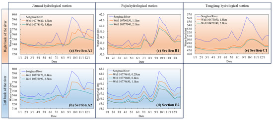
Figure 4.
The process lines of river and groundwater levels for observation cross-sections: the red rows represent the cross-sections of the right bank of the Songhua River, while the blue rows represent the cross-sections of the left bank. Each column corresponds to a different location along the river.
Figure 4 reveals that the water levels of the Songhua River at each observation cross-section were almost consistently higher than those of the adjacent groundwater throughout the year. The groundwater levels closely followed the fluctuations of the river water levels, but with reduced amplitude and a more delayed response. This indicates a perennial-recharge-type groundwater regime [46,47,48]. The peaks and amplitudes of the groundwater level fluctuations gradually decreased with increasing distance from the river. In the two cross-sections from the Jiamusi hydrological station (Sections A1 and A2), it was observed that, beyond 3.5 km from the riverbank, the groundwater level fluctuations no longer closely synchronized with the river level changes. Moreover, from January to June, the groundwater levels beyond 3.5 km from the riverbank were higher than those closer, deviating from the usual pattern of lower groundwater levels farther from the river. This suggests that groundwater farther from the river is only influenced by the river during the flood season. In the two cross-sections from the Fujin hydrological station (Sections B1 and B2), the fluctuations in the groundwater levels at different distances from the river showed a strong correlation with the river’s fluctuations. This correlation indicates a close hydraulic connection between the Songhua River and the adjacent groundwater here, with a significant recharge influence. At Tongjiang hydrological station (Section C1), the groundwater levels beyond 1.5 km from the river showed a notable difference from the river levels. Although these groundwater levels reflected some influence from the surface water, the peaks were not prominent, and the fluctuations were minimal.
3.1.2. Hydraulic Characteristics of Flow Field
To make the contour lines near the river more indicative, the river water levels were interpolated together with the groundwater levels to create a contour map of the study area. However, due to the limited number of hydrological stations within the study area, controlling the water levels across all river sections was challenging. Therefore, linear interpolation was employed to add one river water level approximately every 30 km between the stations.
Considering regional precipitation patterns, the seasonal freeze–thaw process [49] (ending in late April), the river flood season, and the field survey sampling period (September), early May and early September in 2020 were selected as representatives of the non-flood and flood seasons, respectively. Contour maps of the study area were created for these seasons (Figure 5) to analyze the hydraulic characteristics of the flow field and the interaction between the Songhua River and the groundwater from a planar perspective.
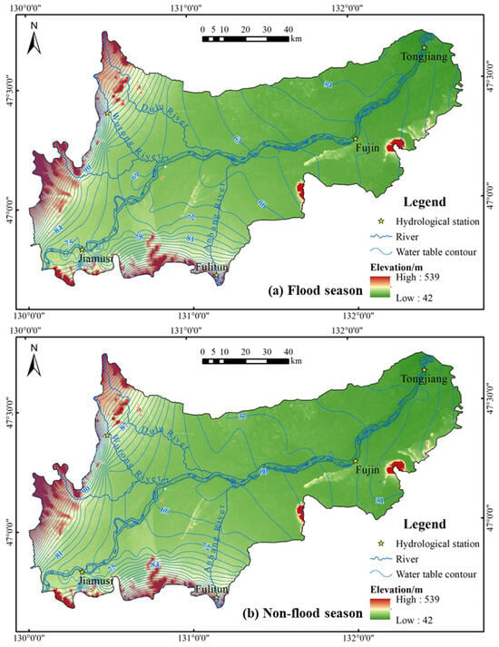
Figure 5.
Water table contour maps for (a) the flood season (1 May 2020) and (b) the non-flood season (1 September 2020).
Figure 5 indicates that the contour line distribution patterns during both the flood and non-flood seasons are similar, reflecting largely consistent interaction characteristics. However, the groundwater levels during the flood season are notably higher than those during the non-flood season. Overall, terrain influences the basin’s general groundwater flow direction, which is from southwest to northeast, generally aligning with the river flow direction. In the northwest and southwest, near the foothills, the groundwater contour lines are denser, indicating a steep hydraulic gradient and faster runoff conditions. In contrast, the contour lines in the central and eastern parts of the basin are relatively sparse, indicating slower groundwater flow. In some areas, due to microtopography, groundwater extraction, or other factors, the local flow fields deviate significantly from the overall pattern.
In the section of the Songhua River from Jiamusi to the confluence with the Wutong River, influenced by the terrain, the regional groundwater generally flows toward the Songhua River. However, near Jiamusi, a groundwater depression cone is observed, with the groundwater level near the riverbank being lower than the river’s (Figure 4a,b). From the Wutong River confluence to the Tongjiang section, the contour lines near the Songhua River form a downstream-pointing “V” shape during both the flood and non-flood seasons, clearly indicating surface water recharge to the groundwater.
3.2. Hydrochemical Analysis
Table 2 presents the test results for water quality samples. Comparatively, the groundwater is more saline and acidic than the surface water, and the concentrations of each indicator are higher and more variable. The average values of various cations and anions indicate that both the Songhua River water and the groundwater are characterized by the highest concentrations of Ca2+ and HCO3−.

Table 2.
Statistical summary of water quality indicators for samples (all indicators are expressed in mg/L, except for pH, and COV denotes the coefficient of variation).
Figure 6 shows that the TDS of the groundwater on both sides of the river is lower than that found in areas far from the river. Low-TDS zones are observed near the western Jiamusi area, the northwestern confluences (Dulu River and Wutong River), the eastern Leye area, and the southern upstream Anbang River area. Conversely, high TDS zones are found on both sides of the Songhua River near Puyang. Given the low salinity (averaging 171.13 mg/L) and the small data variability of the surface water, this distribution pattern may indicate that the adjacent groundwater is recharged by lower-salinity river water, leading to a mixed dilution effect.
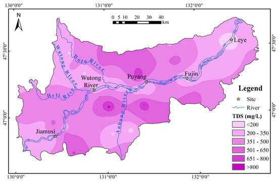
Figure 6.
TDS interpolation distribution in the study area.
The groundwater samples were categorized as Near-bank groundwater and Off-bank groundwater based on a 4.5 km distance from the riverbank to better analyze the interaction between the Songhua River and the groundwater. As shown in Figure 7, Ca2+ and HCO3− dominate the ionic composition of the river, with all river water samples belonging to the HCO3-Ca type. The Near-bank groundwater also shows Ca2+ and HCO3− as dominant ions, with hydrochemical types primarily being HCO3-Ca and Mixed. Most Near-bank groundwater samples are close to the surface water samples on the Piper diagram, and their TDS values are also very similar. High TDS waters are primarily found in Off-bank groundwater, which comprises numerous samples spread across the study area. These samples, having experienced various hydrogeochemical processes, are the most dispersed on the diagram. The dominant ions in the Off-bank groundwater are Ca2+, HCO3−, and Cl−, with a few low-TDS HCO3-Ca-type samples, but the majority are Mixed or Cl-Ca types. The diversity of hydrochemical types is shaped by various hydrogeochemical environments, which can be partially interpreted using the Gibbs diagram (Figure 8) [43]. Compared to the Songhua River water, the basin’s groundwater undergoes more extensive water–rock interactions within the aquifer, with the Off-bank groundwater being more significantly influenced by water–rock interactions than the Near-bank groundwater. The Off-bank groundwater is also subject to evaporative concentration. River water and some Near-bank groundwater are recharged by rainfall. Furthermore, excessive fertilization, sewage discharge, and other human activities in this large agricultural production base may directly or indirectly impact regional water quality [50].
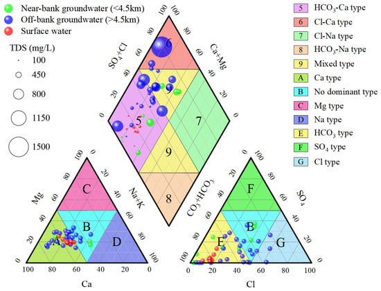
Figure 7.
Piper diagram of water quality samples.
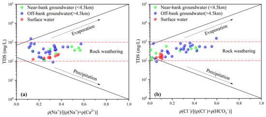
Figure 8.
Gibbs diagram of water quality samples, including (a) TDS vs. cations and (b) TDS vs. anions.
3.3. Isotopic Analysis
3.3.1. Stable Isotopic Composition of Water
The δD values of the surface water range from −86.2‰ to −75.1‰, with an average of −77.8‰ (Table 3). The δ18O values range from −11.7‰ to −9.8‰, averaging −10.3‰. The groundwater δD ranges from −95.1‰ to −77.7‰, with an average of −84.3‰, and δ18O ranges from −12.6‰ to −9.2‰, averaging −10.9‰. Compared to the groundwater, the surface water shows a smaller isotopic range and greater heavy isotope enrichment.

Table 3.
Statistical summary of stable isotopes of samples.
Based on the monthly precipitation isotope composition at Sanjiang Station [51], Zhang et al. [39] determined that the local meteoric water line (LMWL) is δD = 7.3δ18O−6.7 (Figure 9). The water samples are distributed near the LMWL, indicating that precipitation is a significant recharge source for both surface water and groundwater in the basin [40]. The points of the two water bodies are intermixed on the graph, with similar trend lines, suggesting a hydraulic connection between them. The slopes and intercepts of δD–δ18O relationships for both surface water and groundwater are smaller than those of the LMWL, indicating that both water bodies are affected by varying degrees of evaporative fractionation. Surface water points deviate further from the LMWL on the graph, corresponding to the statistical results that show that the surface water is more enriched in heavy isotopes than the groundwater. This likely reflects a more direct evaporative fractionation effect on the Songhua River.
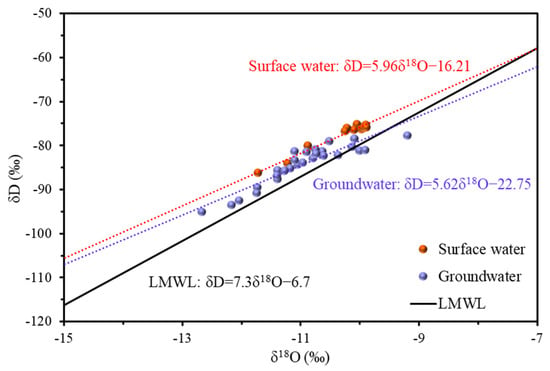
Figure 9.
The δD–δ18O relationship of isotopic samples: the red and blue dotted lines represent the fitted δD–δ18O relationship lines for surface water samples and groundwater samples, respectively.
3.3.2. Distribution Characteristics and Indications of Stable Isotopes
- (1)
- Analysis of isotopic variations along river
The variation curves of δD and δ18O values for the Songhua River and adjacent groundwater along the river are presented in Figure 10. Panels (a) and (b) show the δD and δ18O variations on the right bank, while panels (c) and (d) display the corresponding variations on the left bank. Given the width of the Songhua River and potential spatial variability in groundwater–surface water interactions between the banks, isotope samples of surface water were collected separately from both banks at the same cross-sections during the field surveys (September 2023).
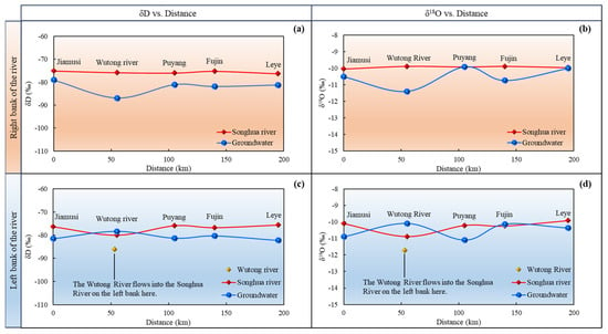
Figure 10.
Stable isotope variations in surface and groundwater along the river on both the left and right banks: the horizontal axis represents the distance from the upstream boundary of the river within the study area, while the vertical axis represents the isotope values. (a) δD changes on the right bank of the Songhua River; (b) δ18O changes on the right bank; (c) δD changes on the left bank; (d) δ18O changes on the left bank.
Overall, the stable isotope values of the Songhua River on both banks remain steady, except for a dip observed on the left bank at the confluence with the Wutong River. This dip is caused by the inflow of the Wutong River, where the δD and δ18O values are −86.2‰ and −11.7‰, respectively (Figure 10c,d), leading to a depletion in isotope values at this location. In contrast, the stable isotope curves of the adjacent groundwater exhibit more fluctuations, indicating a higher likelihood of recharge from other water sources.
The isotope curve on the right bank of the Songhua River is relatively flat, indicating no significant influence from external water sources. At Jiamusi, Puyang, Fujin, and Leye, the stable isotope values of the groundwater are very close to those of the river. In Figure 10b, the values at Leye and Puyang are even identical, confirming that the river is the primary recharge source for the adjacent groundwater. The lower isotope values in the groundwater near the Wutong River may suggest rainfall influence in that area.
The isotope variation along the left bank of the Songhua River also shows consistent water sources between the two water bodies. From Jiamusi to the Wutong River, the groundwater isotope values rise, likely due to recharge from the river water enriched in heavy isotopes, aligning with surface water levels. Between the Wutong River and Puyang, the groundwater isotope values slightly decrease, likely due to recharge from the river water mixed with tributary inflows. From there to Leye, the groundwater isotope values remain consistent with those of the surface water (Figure 10d), indicating a close hydraulic connection and a stable interaction.
- (2)
- Analysis of isotopic variations along cross-sections
Based on the distribution of the isotope samples, three cross-sections at the Wutong River, Puyang, and Fujin were selected in order to analyze stable isotope variations. Given the similar and correlated variation patterns between D and 18O, and the more stable reactivity of 18O, only 18O was analyzed in detail.
Figure 11 presents the δ18O variation curves for three cross-sections, distinguishing the left and right banks. Apart from the influence of the Wutong River tributary on the left bank, the δ18O values of the Songhua River remain stable at around −10‰. As the distance from the river increases, the groundwater δ18O values on both banks generally decrease before rising. As discussed earlier, the isotopic signature of groundwater recharge from the Songhua River is clearly observable. Therefore, with increasing distance from the riverbank, the groundwater gradually moves beyond the river’s influence, leading to divergence from the river’s δ18O values. In the Wutong River’s cross-section, the δ18O values of the groundwater 1 km from the left bank are similar to those of the river but decrease significantly 4 km from the right bank. In the Puyang cross-section, groundwater 3.5 km from the right bank matches the river’s δ18O values, while the values decrease 5 km from the left bank. Similarly, in the Fujin cross-section, groundwater 1.7 km from the left bank aligns with the river but drops 4 km from the right bank. The Songhua River’s main recharge influence on groundwater extends approximately 3.5 km from the riverbank, within which both water bodies maintain similar isotopic values.
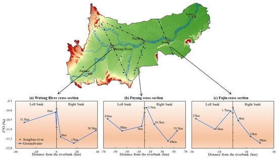
Figure 11.
Stable isotope variations in surface and groundwater across the sections of both the left and right banks (the horizontal axis represents the straight-line distance from the river, and the vertical axis represents 18O values).
3.4. Combined Indicators of the Interaction between the Songhua River and Groundwater
The interaction between surface water and groundwater is influenced by regional geomorphology, hydrological runoff, riverbed characteristics, and human activities [31]. This section of the Songhua River within the Sanjiang Plain lies in the lower reaches, where the terrain is flat, the river valley is wide, and the surface clay layer is thin. In some areas along the riverbanks, there is no clay cover, leading to high hydraulic permeability. Additionally, with the large-scale expansion of agriculture relying on groundwater for irrigation, regional groundwater levels have declined [35,52]. As a result, analyses based on hydraulic, hydrochemical, or isotopic characteristics—whether cross-sectional or planar, along or across the river—consistently show a close hydraulic connection between the river and the surrounding groundwater, with the surface water recharging the groundwater.
The hydraulic head difference is the fundamental mechanism driving water circulation between the two systems. The hydraulic characteristics demonstrate that the Songhua River’s water level consistently exceeds that of the adjacent groundwater throughout the year, indicating that surface water has the hydraulic conditions to continuously recharge the aquifer. Additionally, these characteristics reveal the limited and variable extent of the Songhua River’s influence, which becomes more pronounced and extensive during the flood season. Notably, the north and south sides of Jiamusi lie near the Zhangguangcai and Lesser Khingan mountain ranges. The terrain directs the regional groundwater flow towards the Songhua River Valley, theoretically leading to the groundwater recharging the river. However, the cross-sectional water level lines (Figure 4a,b) indicate that the groundwater levels on both sides of the riverbank in Jiamusi are still lower than the river level, and a significant depression cone is visible in the water table map (Figure 5), demonstrating that surface water still actively recharges the groundwater. This is closely linked to the perennial exploitation of groundwater in the Jiamusi urban area, leading to a decline in groundwater levels, which in turn has increased the capture of surface water [53,54]. A similar situation is observed in Tongjiang, where water table contours indicate that the groundwater flow continues eastward beyond the study area, and the adjacent groundwater levels are far below the river level (Figure 4e). This is attributed to the area’s proximity to the western edge of the Jiansanjiang groundwater depression cone [55], where groundwater extraction induces the infiltration of Songhua River water into the local groundwater [56]. Before reclamation, the study area was characterized by extensive marshlands, with groundwater levels generally higher than the surface water, sustaining numerous surface water bodies [35,39]. As farmland expands and agricultural groundwater extraction continues, groundwater levels have declined, causing many surface water bodies to lose their connection with groundwater and either disappear or shrink. Based on 1994–1995 monitoring data, Guo et al. [37] found that, under natural conditions, the Jiamusi section of the Songhua River was recharged by groundwater. However, in areas affected by extraction, groundwater was recharged by surface water, indicating that, by the late 20th century, riparian groundwater extraction had already begun to reverse the local interaction patterns. Over time, human activities have completely altered the natural interaction between this river section and the groundwater [4]. Certainly, hydraulic analysis offers a preliminary assessment of the interaction between the surface water and the groundwater in the Sanjiang Plain and provides mechanistic insights. However, for large-scale analyses, whether cross-sectional or planar, the accuracy of the conclusions is limited by the quantity and density of the monitoring data, necessitating supplementary methods for further verification and refinement.
Hydrochemical reactions that occur during the water cycle leave evidence that shapes its hydrochemical characteristics. These characteristics, in turn, allow us to infer the processes of the water cycle and interaction. The Songhua River, with its faster runoff and renewal, exists in an open and stable environment. In contrast, groundwater flows slowly within relatively confined aquifers, constantly undergoing water–rock interactions, influenced by various hydrogeochemical processes under different hydrogeological conditions. These factors result in the groundwater having more dispersed hydrochemical indicators, higher salinity, and greater acidity (Table 2). The analyses of the Piper diagram (Figure 7) and Gibbs diagram (Figure 8) show that some of the Near-bank groundwater samples are similar to surface water samples, with similar TDS values. This similarity in hydrochemical characteristics validates the infiltration of surface water recharging the Near-bank groundwater. The TDS distribution (Figure 6) clearly demonstrates the recharge and mixed dilution effects of the Songhua River on the adjacent groundwater. Typically, as groundwater flows over longer distances, water–rock interactions within the aquifer increase, leading to a gradual rise in TDS values along the flow path [24,57]. However, in the northeastern part of the study area, Leye, which is the lowest elevation point and the terminus of the regional groundwater flow field, exhibits the largest low-TDS zone (Figure 6). This suggests that the groundwater here is significantly influenced by recharge and mixing with river water. This conclusion is supported by the hydraulic characteristics observed in the cross-section (Figure 4e) and the water table contour map (Figure 5), likely due to the area’s proximity to the Jiansanjiang groundwater depression cone. It also aligns with findings from other studies that have identified the Songhua River near Leye as a losing river [39]. Located at the lowest reach of the Songhua River, near its confluence with the Heilong River, Leye’s low-lying terrain, historical river course shifts, thick gravel deposits, slow surface runoff, and numerous braided channels and floodplains create the ideal conditions for surface water to recharge groundwater, thereby influencing the regional hydrogeochemical characteristics.
Stable isotopes serve as effective tracers, offering strong and direct evidence of the interaction between the Songhua River and groundwater. The stable isotope values of the river show minimal fluctuations along its course (Figure 10), indicating that the river water remains unmixed with external sources, ruling out the possibility of groundwater recharging the river. The groundwater isotope variation curve (Figure 10) falls between the values of precipitation (with mean δD and δ18O values of −90.3‰ and −12.1‰) and the river water. This suggests that the adjacent groundwater is recharged not only by the river, but also by precipitation, which infiltrates shallow aquifers effectively. This observation is consistent with the δD–δ18O relationship analysis in the water samples (Figure 9) [40]. However, the closer proximity of the groundwater isotope values to those of the river water (Figure 10) indicates that the river water contributes more to recharge than precipitation. The isotopic analysis of the cross-sections (Figure 11) confirms that the river recharges the groundwater, as indicated by the isotopic variation from the riverbank to farther distances. It also reveals that the Songhua River’s influence on the groundwater primarily extends within 3.5 km of the riverbank. This finding corresponds with the cross-sectional water level process lines (Figure 4a,b), where groundwater levels near the riverbank closely follow river levels, while those beyond 3.5 km fluctuate independently, thereby mutually validating the conclusions.
In addition, we compared this study with other research on groundwater–surface water interactions in the same basin. Among them, Zhang et al. [39] sampled and tested (September 2009) stable isotopes (δD and δ¹⁸O), tritium, and chlorofluorocarbons at a regional scale in the Sanjiang Plain, concluding that the Songhua River was a gaining river. Similarly, Wang et al. [38] performed cluster and principal component analyses on water quality data (every November in 2011–2013) collected on a regional scale, arriving at macro-level conclusions that different interaction patterns exist in the upper, middle, and lower reaches of rivers in the Sanjiang Plain. Jia et al. [40] integrated multivariate statistical analysis and hydrochemical data (April 2018) to clarify the spatial variability of groundwater–river interactions in the Songhua River during the dry season. However, firstly, the sampling data that they used are relatively old, and, under the rapidly changing dynamic equilibrium between the surface water and the groundwater in the Sanjiang Plain, the sampling period lacks representativeness for the interactions between the Songhua River and the groundwater over the past five years. In contrast, our study uses more recent data to update and unify their differing conclusions, reflecting the latest interaction states influenced by human exploitation and natural changes. Secondly, their research is mostly focused on large regional scales, resulting in sparse sampling points for research in the small river section scales, making it difficult to construct profiles along or perpendicular to the river, as performed in this study. Their sampling also did not consider the spatial variability of the interactions between upstream, downstream, and both banks. In contrast, from this perspective, the reliability and accuracy of our study’s conclusions are higher. Most importantly, due to the complex and variable hydrogeochemical processes and isotopic fractionation, their study of groundwater–surface water interactions solely through hydrochemical and isotopic data still carries a degree of unreliability. In our study, hydraulic analysis utilized high-frequency monitoring data to directly compare river water levels with adjacent groundwater levels (Figure 4 and Figure 5), allowing us to assess the interactions from the perspective of the driving mechanisms within the water cycle. This was further supplemented and validated by hydrochemical and isotopic methods, leading to robust and reliable conclusions. Overall, the combination of hydraulic and hydrogeochemical analyses to explore groundwater–surface water interactions has proven successful and effective. In future research, regional hydraulic analysis should not be overlooked, and its integration with hydrogeochemical methods deserves broader application.
3.5. Exchange Ratio of the Songhua River and Groundwater
Based on stable isotope data and previously established interaction relationships, the mixing ratios of water sources for the groundwater closest to the riverbank at each Songhua River cross-section were calculated. The average values of δD and δ18O in the precipitation samples (−90.3‰ and −12.1‰) were used for the calculations. The mixing ratios for each location were calculated separately using δD and δ18O, with the final ratio being the average of the two.
The calculation results (Table 4) quantitatively reaffirm that the adjacent groundwater is primarily recharged by the surface water and highlight the spatial variability in groundwater–surface water interactions, with mixing ratios varying between upstream and downstream, as well as between the left and right banks. For instance, at Fujin’s left bank (1.7 km from the riverbank), the mixing ratio of the Songhua River water in the groundwater reaches as high as 89.92%, while, at the right bank of the Wutong River (4 km from the riverbank), the river’s contribution to the groundwater is only 28.21%. This corresponds with the low groundwater values shown in Figure 10a,b at the Wutong River, where rainfall plays a more significant role in recharge. The results also show a general trend of decreasing river water contribution with increasing distance from the river. Within the river’s influence zone (within 3.5 km), the groundwater receives between 62.07% and 89.92% of its recharge from the river, with an average contribution of 78.04%.

Table 4.
Calculation of mixing ratios of water source.
4. Conclusions
The study of groundwater–surface water interactions is complex due to their spatiotemporal variability. The existing research mainly relies on hydrogeochemical methods (hydrochemistry and isotopes), often neglecting the analysis of watershed hydraulic characteristics. This study, focusing on the Songhua River in the Sanjiang Plain, combines hydraulic, hydrochemical, and isotopic methods to clarify groundwater–surface water interactions from both driving mechanism and hydrogeochemical characterization perspectives within the water cycle. Multiple lines of evidence are interlinked and mutually reinforcing, leading to the following key conclusions:
- (1)
- Both cross-sectional and planar hydraulic characteristics indicate that the Songhua River in the basin is a losing river. The riparian groundwater level is significantly influenced by fluctuations in the river’s water level, and the surface water consistently exhibits a hydraulic tendency to recharge the aquifer. Human activities have altered the natural groundwater–surface water interaction patterns, inducing the infiltration of river water into the groundwater.
- (2)
- The hydrochemical type of the Songhua River is entirely HCO3-Ca, while the groundwater in the basin is mainly classified as HCO3-Ca, Mixed, and Cl-Ca types. The hydrochemical characteristics, types, and causes of the riparian groundwater are similar to those of the river water, but both differ significantly from the groundwater farther from the river. The infiltration recharge from the river has led to this water quality similarity, resulting in the mixing and dilution of the adjacent groundwater and impacting its hydrogeochemical characteristics.
- (3)
- The influence of the river water on groundwater recharge varies over time, being more significant during the flood season. The river’s influence extends within 3.5 km of the riverbank, contributing between 62.07% and 89.92% to groundwater recharge, with an average of 78.04%.
- (4)
- The calculated mixing ratios quantify the spatial variability of the Songhua River–groundwater interactions, revealing differences between upstream and downstream, as well as between the left and right banks. Rainfall’s contribution to the adjacent groundwater recharge is significantly less than that of the river.
This study enhances the understanding of the basin’s water cycle processes and offers insights for optimizing local urban and agricultural water management, supporting water-saving and ecological development strategies in agricultural areas. However, a limitation of this study is the insufficient exploration of the temporal variability of interactions, especially during the non-flood season, where only high-resolution water level data are available to determine the mechanisms, lacking supporting hydrogeochemical evidence. Additionally, the isotopic values of rainfall used for calculating mixing ratios should also be supported by data from other periods. In the future, attention should be given to collecting data on water levels, hydrogeochemistry, and precipitation across different periods and time scales in order to enhance the detailed identification of groundwater–surface water interactions and their exchange intensity. In addition, regional hydraulic analysis should not be overlooked, and its integration with hydrogeochemical methods deserves broader application.
Author Contributions
Z.L.: Methodology, Investigation, Formal Analysis, Visualization, Writing—original draft. Y.F.: Investigation, Validation. B.M.: Investigation, Data curation. H.G.: Data curation, Supervision. X.D.: Conceptualization, Methodology, Writing—review and editing, Supervision. All authors have read and agreed to the published version of the manuscript.
Funding
This research was funded by National Natural Science Foundation of China (grant number 41972247) and Heilongjiang Province Key Research and Development Program (grant number JD22B001).
Data Availability Statement
The data presented in this study are available on request from the corresponding author. The data are not publicly available due to uniqueness and confidentiality of datasets.
Conflicts of Interest
The authors declare no conflicts of interest.
References
- Sophocleous, M. Interactions between Groundwater and Surface Water: The State of the Science. Hydrogeol. J. 2002, 10, 52–67. [Google Scholar] [CrossRef]
- Navarro-Martinez, F.; Salas Garcia, A.; Sánchez-Martos, F.; Baeza Espasa, A.; Molina Sánchez, L.; Rodríguez Perulero, A. Radionuclides as Natural Tracers of the Interaction between Groundwater and Surface Water in the River Andarax, Spain. J. Environ. Radioact. 2017, 180, 9–18. [Google Scholar] [CrossRef] [PubMed]
- Lewandowski, J.; Meinikmann, K.; Krause, S. Groundwater–Surface Water Interactions: Recent Advances and Interdisciplinary Challenges. Water 2020, 12, 296. [Google Scholar] [CrossRef]
- Yang, Z.; Zhou, Y.; Wenninger, J.; Uhlenbrook, S.; Wang, X.; Wan, L. Groundwater and Surface-Water Interactions and Impacts of Human Activities in the Hailiutu Catchment, Northwest China. Hydrogeol. J. 2017, 25, 1341–1355. [Google Scholar] [CrossRef]
- Hildebrandt, A.; Guillamón, M.; Lacorte, S.; Tauler, R.; Barceló, D. Impact of Pesticides Used in Agriculture and Vineyards to Surface and Groundwater Quality (North Spain). Water Res. 2008, 42, 3315–3326. [Google Scholar] [CrossRef]
- van Driezum, I.H.; Chik, A.H.S.; Jakwerth, S.; Lindner, G.; Farnleitner, A.H.; Sommer, R.; Blaschke, A.P.; Kirschner, A.K.T. Spatiotemporal Analysis of Bacterial Biomass and Activity to Understand Surface and Groundwater Interactions in a Highly Dynamic Riverbank Filtration System. Sci. Total Environ. 2018, 627, 450–461. [Google Scholar] [CrossRef]
- Chen, K.; Chen, X.; Stegen, J.C.; Villa, J.A.; Bohrer, G.; Song, X.; Chang, K.-Y.; Kaufman, M.; Liang, X.; Guo, Z.; et al. Vertical Hydrologic Exchange Flows Control Methane Emissions from Riverbed Sediments. Environ. Sci. Technol. 2023, 57, 4014–4026. [Google Scholar] [CrossRef]
- Correa, R.E.; Cardenas, M.B.; Rodolfo, R.S.; Lapus, M.R.; Davis, K.L.; Giles, A.B.; Fullon, J.C.; Hajati, M.-C.; Moosdorf, N.; Sanders, C.J.; et al. Submarine Groundwater Discharge Releases CO2 to a Coral Reef. ACS EST Water 2021, 1, 1756–1764. [Google Scholar] [CrossRef]
- Winter, T.C. Relation of Streams, Lakes, and Wetlands to Groundwater Flow Systems. Hydrogeol. J. 1999, 7, 28–45. [Google Scholar] [CrossRef]
- Larned, S.T.; Gooseff, M.N.; Packman, A.I.; Rugel, K.; Wondzell, S.M. Groundwater–Surface-Water Interactions: Current Research Directions. Freshw. Sci. 2015, 34, 92–98. [Google Scholar] [CrossRef]
- Jolly, I.D.; McEwan, K.L.; Holland, K.L. A Review of Groundwater–Surface Water Interactions in Arid/Semi-Arid Wetlands and the Consequences of Salinity for Wetland Ecology. Ecohydrology 2008, 1, 43–58. [Google Scholar] [CrossRef]
- Schmadel, N.M.; Ward, A.S.; Kurz, M.J.; Fleckenstein, J.H.; Zarnetske, J.P.; Hannah, D.M.; Blume, T.; Vieweg, M.; Blaen, P.J.; Schmidt, C.; et al. Stream Solute Tracer Timescales Changing with Discharge and Reach Length Confound Process Interpretation. Water Resour. Res. 2016, 52, 3227–3245. [Google Scholar] [CrossRef]
- Landon, M.K.; Rus, D.L.; Edwin Harvey, F. Comparison of Instream Methods for Measuring Hydraulic Conductivity in Sandy Streambeds. Ground Water 2001, 39, 870–885. [Google Scholar] [CrossRef]
- Yao, Y.; Huang, X.; Liu, J.; Zheng, C.; He, X.; Liu, C. Spatiotemporal Variation of River Temperature as a Predictor of Groundwater/Surface-Water Interactions in an Arid Watershed in China. Hydrogeol. J. 2015, 23, 999–1007. [Google Scholar] [CrossRef]
- Munz, M.; Oswald, S.E.; Schmidt, C. Analysis of Riverbed Temperatures to Determine the Geometry of Subsurface Water Flow around In-Stream Geomorphological Structures. J. Hydrol. 2016, 539, 74–87. [Google Scholar] [CrossRef]
- Naranjo, G.; Cruz-Fuentes, T.; Cabrera, M.C.; Custodio, E. Estimating Natural Recharge by Means of Chloride Mass Balance in a Volcanic Aquifer: Northeastern Gran Canaria (Canary Islands, Spain). Water 2015, 7, 2555–2574. [Google Scholar] [CrossRef]
- Kalbus, E.; Schmidt, C.; Molson, J.W.; Reinstorf, F.; Schirmer, M. Influence of Aquifer and Streambed Heterogeneity on the Distribution of Groundwater Discharge. Hydrol. Earth Syst. Sci. 2009, 13, 69–77. [Google Scholar] [CrossRef]
- Trauth, N.; Fleckenstein, J.H. Single Discharge Events Increase Reactive Efficiency of the Hyporheic Zone. Water Resour. Res. 2017, 53, 779–798. [Google Scholar] [CrossRef]
- Trauth, N.; Schmidt, C.; Vieweg, M.; Oswald, S.E.; Fleckenstein, J.H. Hydraulic Controls of In-Stream Gravel Bar Hyporheic Exchange and Reactions. Water Resour. Res. 2015, 51, 2243–2263. [Google Scholar] [CrossRef]
- Banerjee, D.; Ganguly, S. A Review on the Research Advances in Groundwater-Surface Water Interaction with an Overview of the Phenomenon. Water 2023, 15, 1552. [Google Scholar] [CrossRef]
- Wang, G.; Wang, Y.; Liu, F.; Guo, H. Advances and Trends in Hydrogeochemical Studies: Insights from Bibliometricanalysis. Earth Sci. Front. 2022, 29, 25–36. [Google Scholar] [CrossRef]
- Liu, Y.; Feng, Y.; Jiang, X. South-to-North Water Transfers and Water Science & Technology. S. N. Water Transf. Water Sci. Technol. 2022, 20, 218–229. [Google Scholar] [CrossRef]
- Wang, X.; Jia, S.; Xu, Y.J.; Liu, Z.; Mao, B. Dual Stable Isotopes to Rethink the Watershed-Scale Spatiotemporal Interaction between Surface Water and Groundwater. J. Environ. Manage. 2024, 351, 119728. [Google Scholar] [CrossRef] [PubMed]
- Yang, N.; Zhou, P.; Wang, G.; Zhang, B.; Shi, Z.; Liao, F.; Li, B.; Chen, X.; Guo, L.; Dang, X.; et al. Hydrochemical and Isotopic Interpretation of Interactions between Surface Water and Groundwater in Delingha, Northwest China. J. Hydrol. 2021, 598, 126243. [Google Scholar] [CrossRef]
- Yin, Z.; Luo, Q.; Wu, J.; Xu, S.; Wu, J. Identification of the Long-Term Variations of Groundwater and Their Governing Factors Based on Hydrochemical and Isotopic Data in a River Basin. J. Hydrol. 2021, 592, 125604. [Google Scholar] [CrossRef]
- Okwir, G.; Kumar, S.; Pramod, K.S.; Gao, H.; Njau, K.N. Conceptualization of Groundwater-Surface Water Interaction with Evidence from Environmental Isotopes and Hydrogeochemistry in Lake Babati Basin in Northern Tanzania. Groundw. Sustain. Dev. 2023, 21, 100940. [Google Scholar] [CrossRef]
- Modie, L.T.; Kenabatho, P.K.; Stephens, M.; Mosekiemang, T. Investigating Groundwater and Surface Water Interactions Using Stable Isotopes and Hydrochemistry in the Notwane River Catchment, South East Botswana. J. Hydrol.-Reg. Stud. 2022, 40, 101014. [Google Scholar] [CrossRef]
- Wang, W.; Chen, Y.; Wang, W.; Zhu, C.; Chen, Y.; Liu, X.; Zhang, T. Water Quality and Interaction between Groundwater and Surface Water Impacted by Agricultural Activities in an Oasis-Desert Region. J. Hydrol. 2023, 617, 128937. [Google Scholar] [CrossRef]
- Meng, B. Study on the Interaction between Surface Water and Groundwater in Seasonally Frozen Soil Area: A Case Study of Songhua River Basin in Sanjiang Plain. Master’s Thesis, Jilin University, Changchun, China, 2022. [Google Scholar]
- Mahlknecht, J.; Schneider, J.; Merkel, B.; de León, I.N.; Bernasconi, S. Groundwater Recharge in a Sedimentary Basin in Semi-Arid Mexico. Hydrogeol. J. 2004, 12, 511–530. [Google Scholar] [CrossRef]
- Woessner, W.W. Groundwater-Surface Water Exchange; The Groundwater Project: Guelph, ON, Canada, 2020; ISBN 978-1-77705-415-1. [Google Scholar]
- Chabi, B.G.; Alassane, A.; Kpegli, K.A.R.; Lawson, F.M.A.; Zakari, A.A.; Koukpohounsi, B.D.; Boukari, O.T.; Vouillamoz, J.-M.; Yalo, N.; Mama, D.; et al. Characterising Groundwater and Surface-Water Interconnections Using Hydrogeology, Hydrochemistry and Stable Isotopes in the Oueme Delta, Southern Benin. Hydrogeol. J. 2023, 31, 1229–1243. [Google Scholar] [CrossRef]
- Ma, Q.; Zhang, Y. Global Research Trends and Hotspots on Submarine Groundwater Discharge (SGD): A Bibliometric Analysis. Int. J. Environ. Res. Public Health 2020, 17, 830. [Google Scholar] [CrossRef] [PubMed]
- Yan, M.; Deng, W.; Chen, P. Climate Change in the Sanjiang Plain Disturbed by Large-Scale Reclamation. J. Geogr. Sci. 2002, 12, 405–412. [Google Scholar] [CrossRef]
- Yin, X.; Chu, Y.; Yang, W. Relationships between marsh and precipitation, terrain surface water, groundwater in Sanjiang Plain. Chin. J. Eco-Agric. 2003, 11, 157–158. [Google Scholar]
- Yang, X.; Yang, W.; Zhang, F.; Chu, Y.; Wang, Y. Geological Investigation and Evaluation of Groundwater Resources Potential and Ecological Environment in the Sanjiang Plain; Geological Publishing House: Beijing, China, 2008; ISBN 978-7-116-06094-4. [Google Scholar]
- Guo, Y.; Zhang, W.; Cao, W.; Qu, C.; Zhao, M. Analysis of the relationship between river water and groundwater recharge and drainage in the Jiamusi River section of Songhua River. J. Heilongjiang Hydrol. Univ. 1997, 24, 53–58. [Google Scholar]
- Wang, X.; Zhang, G.; Xu, Y.J.; Sun, G. Identifying the Regional-Scale Groundwater-Surface Water Interaction on the Sanjiang Plain, Northeast China. Environ. Sci. Pollut. Res. 2015, 22, 16951–16961. [Google Scholar] [CrossRef]
- Zhang, B.; Song, X.; Zhang, Y.; Han, D.; Tang, C.; Yang, L.; Wang, Z.; Liu, T. A Study of the Interrelation between Surface Water and Groundwater Using Isotopes and Chlorofluorocarbons in Sanjiang Plain, Northeast China. Environ. Earth Sci. 2014, 72, 3901–3913. [Google Scholar] [CrossRef]
- Jia, S.; Dai, Z.; Du, X.; Meng, B.; Yang, Z.; Lan, T. Quantitative Evaluation of Groundwater and Surface Water Interaction Characteristics during a Dry Season. Water Environ. J. 2021, 35, 1348–1361. [Google Scholar] [CrossRef]
- Deng, Y.; Ye, X.; Feng, J.; Guo, H.; Du, X. Assessment of Soil-Groundwater Nitrogen Cycling Processes in the Agricultural Region through Flux Model, Stable Isotope. J. Hydrol. 2024, 639, 131604. [Google Scholar] [CrossRef]
- Kalbus, E.; Reinstorf, F.; Schirmer, M. Measuring Methods for Groundwater – Surface Water Interactions: A Review. Hydrol. Earth Syst. Sci. 2006, 10, 873–887. [Google Scholar] [CrossRef]
- Gibbs, R.J. Mechanisms Controlling World Water Chemistry. Science 1970, 170, 1088–1090. [Google Scholar] [CrossRef]
- Güler, C.; Thyne, G.D.; McCray, J.E.; Turner, K.A. Evaluation of Graphical and Multivariate Statistical Methods for Classification of Water Chemistry Data. Hydrogeol. J. 2002, 10, 455–474. [Google Scholar] [CrossRef]
- Araguás-Araguás, L.; Froehlich, K.; Rozanski, K. Deuterium and Oxygen-18 Isotope Composition of Precipitation and Atmospheric Moisture. Hydrol. Process. 2000, 14, 1341–1355. [Google Scholar] [CrossRef]
- Cao, J.; Chi, B.; Wang, W.; Gong, H.; Cao, Y.; Liang, X. Applied Hydrogeology; Science Press: Beijing, China, 2006; ISBN 7-03-017547-6. [Google Scholar]
- Ye, X.; Wu, Y.; Du, X.; Li, W. A comprehensive discrimination method for the genetic type of groundwater regime of phreatic water: A case study in the Songhua River basin of the Sanjiang Plain. Adv. Water Sci. 2022, 33, 68–78. [Google Scholar] [CrossRef]
- Duy, N.L.; Nguyen, T.V.K.; Nguyen, D.V.; Tran, A.T.; Nguyen, H.T.; Heidbüchel, I.; Merz, B.; Apel, H. Groundwater Dynamics in the Vietnamese Mekong Delta: Trends, Memory Effects, and Response Times. J. Hydrol. Reg. Stud. 2021, 33, 100746. [Google Scholar] [CrossRef]
- Lou, H.; Yang, S.; Hao, F.; Jiang, L.; Zhao, C.; Ren, X.; Wang, Y.; Wang, Z. SMAP, RS-DTVGM, and in-Situ Monitoring: Which Performs Best in Presenting the Soil Moisture in the Middle-High Latitude Frozen Area in the Sanjiang Plain, China? J. Hydrol. 2019, 571, 300–310. [Google Scholar] [CrossRef]
- Ye, X.; Zhou, Y.; Lu, Y.; Du, X. Hydrochemical Evolution and Quality Assessment of Groundwater in the Sanjiang Plain, China. Water 2022, 14, 1265. [Google Scholar] [CrossRef]
- Liu, J.; Song, X.; Yuan, G.; Sun, X.; Yang, L. Stable Isotopic Compositions of Precipitation in China. Tellus B Chem. Phys. Meteorol. 2014, 66, 22567. [Google Scholar] [CrossRef]
- Liu, J.; Chen, H. Conjunctive Use of Groundwater and Surface Water for Paddy Rice Irrigation in Sanjiang Plain, North-East China. Irrig. Drain. 2020, 69, 142–152. [Google Scholar] [CrossRef]
- Fu, Q.; Li, T.; Liu, D.; Dong, H. Simulation Study of the Sustainable Utilization of Urban Water Resources Based on System Dynamics: A Case Study of Jiamusi. Water Supply 2016, 16, 980–991. [Google Scholar] [CrossRef]
- Barlow, P.M.; Leake, S.A.; Fienen, M.N. Capture Versus Capture Zones: Clarifying Terminology Related to Sources of Water to Wells. Groundwater 2018, 56, 694–704. [Google Scholar] [CrossRef]
- Li, H.; Du, X.; Lu, X.; Fang, M. Analysis of Groundwater Overexploitation Based on Groundwater Regime Information. Groundwater 2023, 61, 692–705. [Google Scholar] [CrossRef] [PubMed]
- Cao, Y.; Du, S.; An, R.; Yao, Z. A new discussion on groundwater system and stimulated recharge mechanism in the Sanjiang Plain. J. Heilongjiang Hydrol. Univ. 2008, 5–7. [Google Scholar] [CrossRef]
- Wang, W.; Chen, Y.; Chen, Y.; Wang, W.; Zhang, T.; Qin, J. Groundwater Dynamic Influenced by Intense Anthropogenic Activities in a Dried-up River Oasis of Central Asia. Hydrol. Res. 2022, 53, 532–546. [Google Scholar] [CrossRef]
Disclaimer/Publisher’s Note: The statements, opinions and data contained in all publications are solely those of the individual author(s) and contributor(s) and not of MDPI and/or the editor(s). MDPI and/or the editor(s) disclaim responsibility for any injury to people or property resulting from any ideas, methods, instructions or products referred to in the content. |
© 2024 by the authors. Licensee MDPI, Basel, Switzerland. This article is an open access article distributed under the terms and conditions of the Creative Commons Attribution (CC BY) license (https://creativecommons.org/licenses/by/4.0/).