Using Sentinel-2 Imagery and Machine Learning Algorithms to Assess the Inundation Status of Nebraska Conservation Easements during 2018–2021



Abstract
1. Introduction
2. Materials and Methods
2.1. Study Area
2.2. Data Sources
2.3. Data Analysis
- (1)
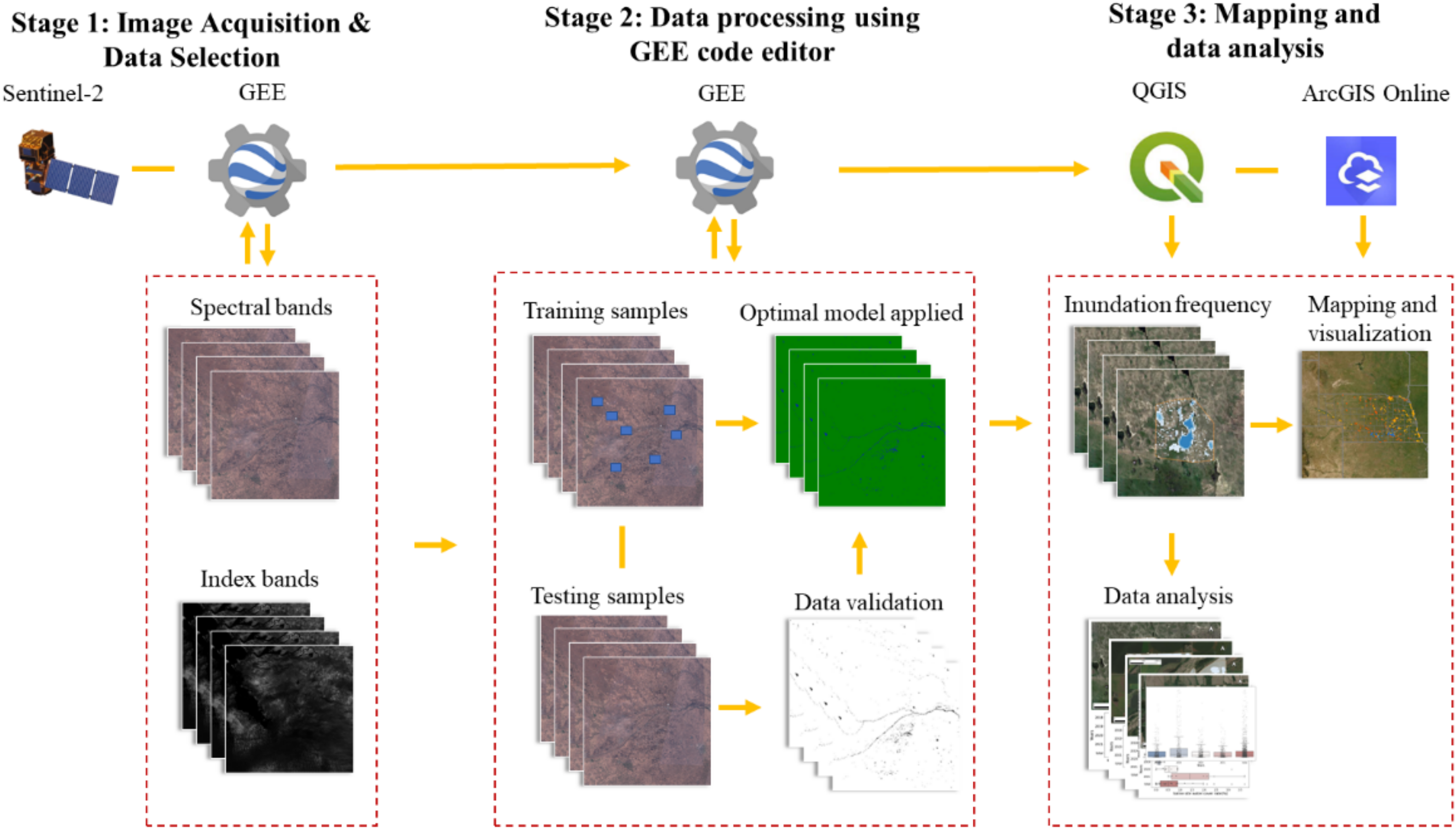
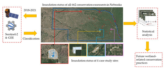
- Selecting geospatial data: For surface water classification, the Sentinel-2 images are imported into GEE and filtered by date (March to November each year from 2018 to 2021). The QA-60 band was used to sort and select the least cloud-covered images. The shapefile of the CE sites is uploaded to GEE as the boundary.
- (2)
- Labeling data: The geometric tool in GEE is used to label different land-cover classes. The Rainwater Basin Annual Habitat Surveys data in 2020 and field surveys in 2021 were used as supportive information to label and verification which confirmed the designations of water and land classes in the training area. Images of RGB, NIR, NDWI, and NDSI created in GEE are used as references to make labels. All 662 CEs in the Nebraska area are separated into five zones (east, mid-east, central, mid-west, and west) to minimize bias and the effect of climate. CEs from each zone each month are used to make labels. About twenty thousand pixels are generated using the randomPoints function. All features input in the classifier are randomly sampled using a random column function. After collecting the sample by the random column function, 70% of the sample is used for training and 30% for testing.
- (3)
- Calculating indices: The built-in normalized difference function of GEE is used to calculate the NDVI, NDWI, NDMI, and MNDWI. Then, those index bands are added together with spectral bands as training bands.
- (4)
- Selecting machine learning classifiers for wetland classification: According to former research, linear kernel SVM is selected as the classifier for all the classifications. All eleven spectral bands and four index bands are applied as training bands.
- (5)
- Calculating surface water cover: The classification results are exported from GEE as TIFF files. QGIS is used to batch process and transfer all TIFF files into shapefiles. Finally, the surface water cover condition in every pixel within all 662 CE sites from 2018 to 2021 is determined.
- (6)
- Calculating the surface water inundation frequency: All water cover data are calculated in the last step. Water cover data for all CE sites are used to calculate the water cover rate. At least 25 images are used for the water cover rate calculation for each site.
- (7)
- Calculating and mapping inundation conditions: Water cover data in every pixel calculated in the last two steps are applied in this step to calculate the pixel inundation frequency in all 662 CE sites. The inundation frequency map is constructed using QGIS and ArcGIS.
2.4. Classification Accuracy Assessment
3. Results
3.1. Soil Conditions with Inundation Frequency
3.2. Case Study
4. Discussion
Policy Recommendations for CEs
5. Conclusions
Author Contributions
Funding
Data Availability Statement
Acknowledgments
Conflicts of Interest
References
- Eichenwald, A.J.; Evans, M.J.; Malcom, J.W. US Imperiled Species Are Most Vulnerable to Habitat Loss on Private Lands. Front. Ecol. Environ. 2020, 18, 439–446. [Google Scholar] [CrossRef] [Scilit]
- Hilty, J.; Merenlender, A.M. Studying Biodiversity on Private Lands. Conserv. Biol. 2003, 17, 132–137. [Google Scholar] [CrossRef] [Scilit]
- Kareiva, P.; Bailey, M.; Brown, D.; Dinkins, B.; Sauls, L.; Todia, G. Documenting the Conservation Value of Easements. Conserv. Sci. Pract. 2021, 3, e451. [Google Scholar] [CrossRef] [Scilit]
- Bastian, C.T.; Keske, C.M.H.; McLeod, D.M.; Hoag, D.L. Landowner and Land Trust Agent Preferences for Conservation Easements: Implications for Sustainable Land Uses and Landscapes. Landsc. Urban Plan. 2017, 157, 1–13. [Google Scholar] [CrossRef] [Scilit]
- Keske, C.M.H.; Arnold, P.; Cross, J.E.; Bastian, C.T. Does Conservation Ethic Include Intergenerational Bequest? A Random Utility Model Analysis of Conservation Easements and Agricultural Landowners. Rural. Sociol. 2021, 86, 703–727. [Google Scholar] [CrossRef] [Scilit]
- Thompson, A.W.; Wadleigh, R. Factors Motivating Forest Conservation Easement Adoption in Wisconsin’s Northwoods. Soc. Nat. Resour. 2022, 35, 129–148. [Google Scholar] [CrossRef] [Scilit]
- Kemink, K.M.; Adams, V.M.; Pressey, R.L.; Walker, J.A. A Synthesis of Knowledge about Motives for Participation in Perpetual Conservation Easements. Conserv. Sci. Pract. 2021, 3, e323. [Google Scholar] [CrossRef] [Scilit]
- Lewis, K.E.; Rota, C.T.; Anderson, J.T. A Comparison of Wetland Characteristics between Agricultural Conservation Easement Program and Public Lands Wetlands in West Virginia, USA. Ecol. Evol. 2020, 10, 3017–3031. [Google Scholar] [CrossRef] [Scilit]
- Farmer, J.R.; Meretsky, V.; Knapp, D.; Chancellor, C.; Fischer, B.C. Why Agree to a Conservation Easement? Understanding the Decision of Conservation Easement Granting. Landsc. Urban Plan. 2015, 138, 11–19. [Google Scholar] [CrossRef] [Scilit]
- Lewis, K.E.; Rota, C.T.; Lituma, C.M.; Anderson, J.T. Influence of the Agricultural Conservation Easement Program Wetland Practices on Winter Occupancy of Passerellidae Sparrows and Avian Species Richness. PLoS ONE 2019, 14, e0210878. [Google Scholar] [CrossRef] [Scilit]
- Braza, M. Effectiveness of conservation easements in agricultural regions. Conserv. Biol. 2017, 31, 848–859. [Google Scholar] [CrossRef] [Scilit]
- Zhang, W.; Mei, B.; Izlar, R.L. Impact of Forest-Related Conservation Easements on Contiguous and Surrounding Property Values. For. Policy Econ. 2018, 93, 30–35. [Google Scholar] [CrossRef] [Scilit]
- Gallant, A.L. The Challenges of Remote Monitoring of Wetlands. Remote Sens. 2015, 7, 10938–10950. [Google Scholar] [CrossRef] [Scilit]
- Yamazaki, D.; Trigg, M.A. The Dynamics of Earth’s Surface Water. Nature 2016, 540, 348–349. [Google Scholar] [CrossRef] [Scilit]
- Pekel, J.-F.; Cottam, A.; Gorelick, N.; Belward, A.S. High-Resolution Mapping of Global Surface Water and Its Long-Term Changes. Nature 2016, 540, 418–422. [Google Scholar] [CrossRef] [Scilit]
- Donchyts, G.; Baart, F.; Winsemius, H.; Gorelick, N.; Kwadijk, J.; van de Giesen, N. Earth’s Surface Water Change over the Past 30 Years. Nat. Clim. Chang. 2016, 6, 810–813. [Google Scholar] [CrossRef] [Scilit]
- Keshtkar, H.; Voigt, W.; Alizadeh, E. Land-Cover Classification and Analysis of Change Using Machine-Learning Classifiers and Multi-Temporal Remote Sensing Imagery. Arab. J. Geosci. 2017, 10, 154. [Google Scholar] [CrossRef] [Scilit]
- Mahdavi, S.; Salehi, B.; Granger, J.; Amani, M.; Brisco, B.; Huang, W. Remote Sensing for Wetland Classification: A Comprehensive Review. GISci. Remote Sens. 2018, 55, 623–658. [Google Scholar] [CrossRef] [Scilit]
- Rodriguez-Galiano, V.F.; Ghimire, B.; Rogan, J.; Chica-Olmo, M.; Rigol-Sanchez, J.P. An Assessment of the Effectiveness of a Random Forest Classifier for Land-Cover Classification. ISPRS J. Photogramm. Remote Sens. 2012, 67, 93–104. [Google Scholar] [CrossRef] [Scilit]
- Ludwig, C.; Walli, A.; Schleicher, C.; Weichselbaum, J.; Riffler, M. A Highly Automated Algorithm for Wetland Detection Using Multi-Temporal Optical Satellite Data. Remote Sens. Environ. 2019, 224, 333–351. [Google Scholar] [CrossRef] [Scilit]
- Ozesmi, S.L.; Bauer, M.E. Satellite Remote Sensing of Wetlands. Wetl. Ecol. Manag. 2002, 10, 381–402. [Google Scholar] [CrossRef] [Scilit]
- Pena-Regueiro, J.; Sebastiá-Frasquet, M.-T.; Estornell, J.; Aguilar-Maldonado, J.A. Sentinel-2 Application to the Surface Characterization of Small Water Bodies in Wetlands. Water 2020, 12, 1487. [Google Scholar] [CrossRef] [Scilit]
- Bwangoy, J.-R.B.; Hansen, M.C.; Roy, D.P.; Grandi, G.D.; Justice, C.O. Wetland Mapping in the Congo Basin Using Optical and Radar Remotely Sensed Data and Derived Topographical Indices. Remote Sens. Environ. 2010, 114, 73–86. [Google Scholar] [CrossRef] [Scilit]
- Davranche, A.; Poulin, B.; Lefebvre, G. Mapping Flooding Regimes in Camargue Wetlands Using Seasonal Multispectral Data. Remote Sens. Environ. 2013, 138, 165–171. [Google Scholar] [CrossRef] [Scilit]
- Islam, M.A.; Thenkabail, P.S.; Kulawardhana, R.W.; Alankara, R.; Gunasinghe, S.; Edussriya, C.; Gunawardana, A. Semi-automated Methods for Mapping Wetlands Using Landsat ETM+ and SRTM Data. Int. J. Remote Sens. 2008, 29, 7077–7106. [Google Scholar] [CrossRef] [Scilit]
- Kulawardhana, R.W.; Thenkabail, P.S.; Vithanage, J.; Biradar, C.; Islam, M.A.; Gunasinghe, S.; Alankara, R. Evaluation of the Wetland Mapping Methods Using Landsat ETM+ and SRTM Data. J. Spat. Hydrol. 2007, 7, 62–96. [Google Scholar]
- Ma, L.; Fu, T.; Blaschke, T.; Li, M.; Tiede, D.; Zhou, Z.; Ma, X.; Chen, D. Evaluation of Feature Selection Methods for Object-Based Land Cover Mapping of Unmanned Aerial Vehicle Imagery Using Random Forest and Support Vector Machine Classifiers. ISPRS Int. J. Geo Inf. 2017, 6, 51. [Google Scholar] [CrossRef] [Scilit]
- Tang, Z.; Li, Y.; Gu, Y.; Jiang, W.; Xue, Y.; Hu, Q.; LaGrange, T.; Bishop, A.; Drahota, J.; Li, R. Assessing Nebraska Playa Wetland Inundation Status during 1985–2015 Using Landsat Data and Google Earth Engine. Environ. Monit. Assess. 2016, 188, 654. [Google Scholar] [CrossRef] [Scilit]
- Abdel-Hamid, A.; Dubovyk, O.; Abou El-Magd, I.; Menz, G. Mapping Mangroves Extents on the Red Sea Coastline in Egypt Using Polarimetric SAR and High Resolution Optical Remote Sensing Data. Sustainability 2018, 10, 646. [Google Scholar] [CrossRef] [Scilit]
- Franklin, S.E.; Skeries, E.M.; Stefanuk, M.A.; Ahmed, O.S. Wetland Classification Using Radarsat-2 SAR Quad-Polarization and Landsat-8 OLI Spectral Response Data: A Case Study in the Hudson Bay Lowlands Ecoregion. Int. J. Remote Sens. 2018, 39, 1615–1627. [Google Scholar] [CrossRef] [Scilit]
- Maxwell, A.E.; Warner, T.A.; Fang, F. Implementation of Machine-Learning Classification in Remote Sensing: An Applied Review. Int. J. Remote Sens. 2018, 39, 2784–2817. [Google Scholar] [CrossRef] [Scilit]
- Kordelas, G.A.; Manakos, I.; Aragonés, D.; Díaz-Delgado, R.; Bustamante, J. Fast and Automatic Data-Driven Thresholding for Inundation Mapping with Sentinel-2 Data. Remote Sens. 2018, 10, 910. [Google Scholar] [CrossRef] [Scilit]
- Lefebvre, G.; Davranche, A.; Willm, L.; Campagna, J.; Redmond, L.; Merle, C.; Guelmami, A.; Poulin, B. Introducing WIW for Detecting the Presence of Water in Wetlands with Landsat and Sentinel Satellites. Remote Sens. 2019, 11, 2210. [Google Scholar] [CrossRef] [Scilit]
- Huang, W.; DeVries, B.; Huang, C.; Lang, M.W.; Jones, J.W.; Creed, I.F.; Carroll, M.L. Automated Extraction of Surface Water Extent from Sentinel-1 Data. Remote Sens. 2018, 10, 797. [Google Scholar] [CrossRef] [Scilit]
- Shao, Y.; Lunetta, R.S. Comparison of Support Vector Machine, Neural Network, and CART Algorithms for the Land-Cover Classification Using Limited Training Data Points. ISPRS J. Photogramm. Remote Sens. 2012, 70, 78–87. [Google Scholar] [CrossRef] [Scilit]
- Whyte, A.; Ferentinos, K.P.; Petropoulos, G.P. A New Synergistic Approach for Monitoring Wetlands Using Sentinels-1 and 2 Data with Object-Based Machine Learning Algorithms. Environ. Model. Softw. 2018, 104, 40–54. [Google Scholar] [CrossRef] [Scilit]
- Xu, X.; Li, W.; Ran, Q.; Du, Q.; Gao, L.; Zhang, B. Multisource Remote Sensing Data Classification Based on Convolutional Neural Network. IEEE Trans. Geosci. Remote Sens. 2018, 56, 937–949. [Google Scholar] [CrossRef] [Scilit]
- Thanh Noi, P.; Kappas, M. Comparison of Random Forest, k-Nearest Neighbor, and Support Vector Machine Classifiers for Land Cover Classification Using Sentinel-2 Imagery. Sensors 2018, 18, 18. [Google Scholar] [CrossRef] [Scilit]
- Sheykhmousa, M.; Mahdianpari, M.; Ghanbari, H.; Mohammadimanesh, F.; Ghamisi, P.; Homayouni, S. Support Vector Machine Versus Random Forest for Remote Sensing Image Classification: A Meta-Analysis and Systematic Review. IEEE J. Sel. Top. Appl. Earth Obs. Remote Sens. 2020, 13, 6308–6325. [Google Scholar] [CrossRef] [Scilit]
- Zhang, L.; Hu, Q.; Tang, Z. Assessing the Contemporary Status of Nebraska’s Eastern Saline Wetlands by Using a Machine Learning Algorithm on the Google Earth Engine Cloud Computing Platform. Environ. Monit. Assess. 2022, 194, 193. [Google Scholar] [CrossRef] [Scilit]
- Dronova, I. Object-Based Image Analysis in Wetland Research: A Review. Remote Sens. 2015, 7, 6380–6413. [Google Scholar] [CrossRef] [Scilit]
- Jia, K.; Jiang, W.; Li, J.; Tang, Z. Spectral Matching Based on Discrete Particle Swarm Optimization: A New Method for Terrestrial Water Body Extraction Using Multi-Temporal Landsat 8 Images. Remote Sens. Environ. 2018, 209, 1–18. [Google Scholar] [CrossRef] [Scilit]
- Mahdianpari, M.; Brisco, B.; Granger, J.E.; Mohammadimanesh, F.; Salehi, B.; Banks, S.; Homayouni, S.; Bourgeau-Chavez, L.; Weng, Q. The Second Generation Canadian Wetland Inventory Map at 10 Meters Resolution Using Google Earth Engine. Can. J. Remote Sens. 2020, 46, 360–375. [Google Scholar] [CrossRef] [Scilit]
- Tamiminia, H.; Salehi, B.; Mahdianpari, M.; Quackenbush, L.; Adeli, S.; Brisco, B. Google Earth Engine for Geo-Big Data Applications: A Meta-Analysis and Systematic Review. ISPRS J. Photogramm. Remote Sens. 2020, 164, 152–170. [Google Scholar] [CrossRef] [Scilit]
- Farda, N.M. Multi-Temporal Land Use Mapping of Coastal Wetlands Area Using Machine Learning in Google Earth Engine. IOP Conf. Ser. Earth Environ. Sci. 2017, 98, 012042. [Google Scholar] [CrossRef] [Scilit]
- Gorelick, N.; Hancher, M.; Dixon, M.; Ilyushchenko, S.; Thau, D.; Moore, R. Google Earth Engine: Planetary-Scale Geospatial Analysis for Everyone. Remote Sens. Environ. 2017, 202, 18–27. [Google Scholar] [CrossRef] [Scilit]
- LaGrange, T. Wetland Program Plan for Nebraska; Nebraska Game and Parks Commission: Lincoln, NE, USA, 2010.
- Gersib, R.A. Nebraska Wetlands Priority Plan; Nebraska Game and Parks Commission: Lincoln, NE, USA, 1991.
- Lang, M.W.; McCarty, G.W. Lidar Intensity for Improved Detection of Inundation below the Forest Canopy. Wetlands 2009, 29, 1166–1178. [Google Scholar] [CrossRef] [Scilit]
- Tang, Z.; Li, R.; Li, X.; Jiang, W.; Hirsh, A. Capturing LiDAR-Derived Hydrologic Spatial Parameters to Evaluate Playa Wetlands. JAWRA J. Am. Water Resour. Assoc. 2014, 50, 234–245. [Google Scholar] [CrossRef] [Scilit]
- Mullissa, A.; Vollrath, A.; Odongo-Braun, C.; Slagter, B.; Balling, J.; Gou, Y.; Gorelick, N.; Reiche, J. Sentinel-1 SAR Backscatter Analysis Ready Data Preparation in Google Earth Engine. Remote Sens. 2021, 13, 1954. [Google Scholar] [CrossRef] [Scilit]
- Brown, C.F.; Brumby, S.P.; Guzder-Williams, B.; Birch, T.; Hyde, S.B.; Mazzariello, J.; Czerwinski, W.; Pasquarella, V.J.; Haertel, R.; Ilyushchenko, S.; et al. Dynamic World, Near Real-Time Global 10 m Land Use Land Cover Mapping. Sci. Data 2022, 9, 251. [Google Scholar] [CrossRef] [Scilit]
- Tang, Z.; Drahota, J.; Hu, Q.; Jiang, W. Examining Playa Wetland Contemporary Conditions in the Rainwater Basin, Nebraska. Wetlands 2018, 38, 25–36. [Google Scholar] [CrossRef] [Scilit]








| Data Sources | Bands | Resolution | Date |
|---|---|---|---|
| Sentinel-2 | B2, B3, B4, B8 | 10 m | March 2018–November 2018 March 2019–November 2019 March 2020–November 2020 March 2021–November 2021 |
| Sentinel-2 | B5, B6, B7, B8, B8a, B11, B12 | 20 m | March 2018–November 2018 March 2019–November 2019 March 2020–November 2020 March 2021–November 2021 |
| Site Count | 2018 | 2019 | 2020 | 2021 | Category Mean | |
|---|---|---|---|---|---|---|
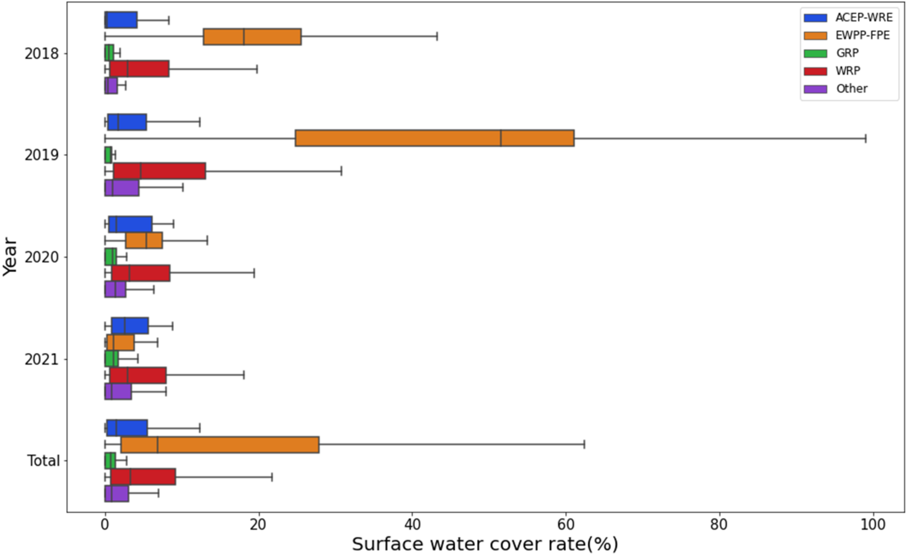
| ACEP-WRE | 22 | 2.88% | 5.36% | 3.68% | 4.56% | 4.12% |
| EWPP | 11 | 19.75% | 44.60% | 8.33% | 2.21% | 18.72% |
| GRP | 13 | 0.91% | 0.60% | 1.00% | 1.35% | 0.96% |
| WRP | 600 | 6.99% | 12.99% | 6.44% | 5.87% | 8.07% |
| Other | 16 | 1.81% | 4.76% | 1.89% | 2.97% | 2.86% |
| Year Mean | 6.82% | 12.82% | 6.17% | 5.61% | 7.85% |
Publisher’s Note: MDPI stays neutral with regard to jurisdictional claims in published maps and institutional affiliations. |
© 2022 by the authors. Licensee MDPI, Basel, Switzerland. This article is an open access article distributed under the terms and conditions of the Creative Commons Attribution (CC BY) license (https://creativecommons.org/licenses/by/4.0/).
Share and Cite
Zhang, L.; Hu, Q.; Tang, Z. Using Sentinel-2 Imagery and Machine Learning Algorithms to Assess the Inundation Status of Nebraska Conservation Easements during 2018–2021. Remote Sens. 2022, 14, 4382. https://doi.org/10.3390/rs14174382
Zhang L, Hu Q, Tang Z. Using Sentinel-2 Imagery and Machine Learning Algorithms to Assess the Inundation Status of Nebraska Conservation Easements during 2018–2021. Remote Sensing. 2022; 14(17):4382. https://doi.org/10.3390/rs14174382
Chicago/Turabian StyleZhang, Ligang, Qiao Hu, and Zhenghong Tang. 2022. "Using Sentinel-2 Imagery and Machine Learning Algorithms to Assess the Inundation Status of Nebraska Conservation Easements during 2018–2021" Remote Sensing 14, no. 17: 4382. https://doi.org/10.3390/rs14174382
APA StyleZhang, L., Hu, Q., & Tang, Z. (2022). Using Sentinel-2 Imagery and Machine Learning Algorithms to Assess the Inundation Status of Nebraska Conservation Easements during 2018–2021. Remote Sensing, 14(17), 4382. https://doi.org/10.3390/rs14174382