Abstract
This paper investigates the possibility of using fusion Sentinel-2 imageries (2016, ESA) and light detection and ranging (LiDAR) point clouds for the automation of land cover mapping with a primary focus on detecting and monitoring afforested areas and deriving precise information about the spatial (2D and 3D) characteristics of vegetation for reclaimed areas. The study was carried out for reclaimed areas – two former sulfur mines located in Southeast Poland, namely, Jeziórko, where 216.5 ha of afforested area was reclaimed after borehole exploitation, and Machów, where 871.7 ha of dump area was reclaimed after open cast strip mining. The current land use and land cover (LULC) classes at the Machów and Jeziórko former sulfur mines are derived based on Sentinel-2 image processing, and confirmed the applied type of reclamation for both analysed areas. The following LULC classes showed a significant spatial range: broad-leaved forest, coniferous forest, and transitional woodland shrub. The progress of afforested areas, not only in terms of the occupied area, but also in terms of the growth of trees and shrubs, was confirmed. The results of the study showed differences in vegetation parameters, namely, height and canopy cover. Various stages of vegetation growth were also observed. This indicates an ongoing process of vegetation development, as an effect of the reclamation treatment for these areas.
1. Introduction
Space management and monitoring environmental changes are nowadays very important issues. Monitoring the land use and land cover (LULC) changes, including the development of forest phytocoenoses, is one of the elements allowing us to observe the changes taking place in the environment, where it seems reasonable to indicate the possibility of automation and the application of the newest technologies and geodata. LULC changes are also essential in regards to the programs of the European Union, including the subject of proper land management and granting direct subsidies to agriculture. Farmers are obliged to maintain their farmland for so-called “good agriculture”, that is, they have to prevent soil erosion and the succession of vegetation as they are not useful for agricultural production [1,2]. This issue is also vital for the assessment of the biomass, renewable energy, and problems of coal sequestration [3].
In modern and sustainable forestry, environmental management, conservation of nature or natural resources, and landscape protection, remote sensing technologies are more and more commonly applied [4,5,6]. The process of land cover mapping, especially in terms of reclaimed areas, is the subject of many papers [7,8,9,10,11,12,13,14,15]. An aspect of the present environmental changes taking on a global approach is the remediation and reconstruction of ecological and utilitarian conditions of post-industrial areas.
Industrial activities related to coal mining have a significant influence on the natural environment, especially on soil conditions [16,17,18]. As a result of mining activities, the natural landscape has been changed, and it is reasonable to control and reclaim post-industrial areas in order to stop environmental degradation, and to reconstruct the environmental and utilitarian conditions of these areas. The most important issue is monitoring the increase in afforested areas in reclaimed places. Monitoring forest vegetation development in post-industrial areas is an important aspect in relation to the assessment of reclamation procedures.
Human activities like industry (e.g., mining) or agriculture strongly influence the natural environment [19,20,21]. During industrial activities, the natural compounds lose the capability to autoregenerate in a timely manner, and the restoration of degraded and destroyed areas are only possible through anthropogenic correction [21,22]. All types of areas under industry (active, inactive, and abandoned) are exposed to danger, for example, erosion, low soil pH, poor nutritional conditions, acid mine drainage phenomena (AMD), migration of undesirable elements and chemical compounds (e.g., trace elements, sulfides), and scare vegetation cover [22,23]. The changes caused by industry can have a negative influence on human health, as well as on the visual aspects of the landscape and environment [22]. According to Gatica-Saavedra et al. [24], reclamation of the natural direction, especially afforestation, is becoming increasingly frequent. The aim of plant introduction (phytostabilisation) to postindustrial areas is dispersion, preventing contaminated particles, water, and wind erosion, reducting metal mobility by rhizosphere-inducted absorption and precipitation processes [21,23]. Moreover, using tree species for reclamation treatment is one of the oldest methods used in reclamation, especially in areas under an open cast mining method. Afforestation’s influence on soil format is a process for the evolution of a postmining ecosystem [25,26]. Additionally, the afforestation of degraded areas with diverse tree species allows for sequestering more carbon, is more resistant, and gives a bigger biomass production [21,25]. Some tree species (pioneer species) are resistant to heavy conditions by using a mechanism against the stressful conditions that occur in degraded areas [25]. Soil is a crucial element, and has the ability to influence restored and newly created ecosystems [21]. Plant recovery is as important as the soil recovery process [25,27]. Introducing trees in the postindustrial area can be hard, because of specific chemical, physical, hydrological, and nutrient soil conditions [21,25]. According to the authors, there are no developed standards of assessment for the effectiveness of such reclamation. Restoration, reclamation, or stabilization ecosystems are processes demanding large amounts of effort and money, and should be controlled [19]. Perhaps a good example is the use of geospatial tools.
Monitoring plant development and their conditions on reclaimed post-industrial areas is one of the most important factors in assessing their adaptation in the restored ecosystem. Plant succession strongly depends on soil parameters and soil formation processes in the restored or reclaimed area—soil is a critical component that interacts with vegetation, climate, and animals [28]. The indicators in the reclamation treatment of forestry can be the following: coverage of the surface by vegetation and overgrowing time. Important indicators used in ecology are ecological factors connected with plant community development, such as biomass and diversity of communities, measured by the number species and the Shannon diversity index, respectively [29,30]. To make an assessment of the natural succession, determining the number of species, biodiversity of communities, and the proportion of species characteristic of forest and non-forest communities are an important part of the analyses [26].
LULC mapping carried out on reclaimed areas, especially for the detection and monitoring of forest succession, and on increasingly afforested areas is a very important aspect [7,8,9,10,11,12,13,14,15]. The issue is to define the possibilities of using remote sensing data and geoinformatics methods for the automatization of this process. Reclaimed areas are characterized by a large dispersion of the land cover classes, which requires particular attention in order to obtain reliable and detailed land use and land cover classification, including about the changing areas of forest vegetation.
Sentinel-2 satellite imageries (European Space Agency; ESA) consist of two satellites: Sentinel-2A (launched in 2015) and Sentinel-2B (launched in 2017). The satellites are equipped with modern multi-spectral high-resolution scanners—13 spectral channels with spatial resolution of 10, 20, and 60 m. Using Sentinel-2 (ESA) imageries opens up new possibilities in environmental studies [11,31,32,33,34], mainly as a result of the good spatial and spectral resolution and short revisit time (five days for two satellites).
LiDAR (light detection and ranging) remote sensing technology offers possibilities for collecting 3D information (point clouds), and allows for the definition of many indices; characterizing vegetation; and provides possibilities for monitoring land cover, together with the identification of the spatial parameters of the vegetation [35,36,37,38,39].
In the case of forested areas, advanced analyses of the vegetation structure are performed, based on the canopy height model (CHM), which is the same as the normalized digital surface model (nDSM, [40]) generated from classes (i.e., ground and vegetation). LiDAR point clouds are employed for collecting 2D and 3D information about vegetation, as they are useful for obtaining precise information about the height of the vegetation and canopy cover. Directly, airborne laser scanning (ALS) point clouds can also be retrieved for other vegetation parameters, such as the light penetration index, the number of trees, the number and area of gaps, the crown size, or the vertical structure of the forest stand (i.e., features that are strongly correlated with the biomass of the vegetation) [41,42,43,44,45,46,47,48].
The general objective of this paper was to define the possibilities of automation in LULC mapping for two former and reclaimed sulfur mine areas, especially the identification of afforested areas and forest succession dynamics, using Sentinel-2 imageries and LiDAR technology. The aim of the study was to identify the potential, for example, increases in vegetation height and canopy cover, using this geodata to highlight the progress of the occupied forested areas for reclaimed areas, as well as the growth of the trees and shrubs.
2. Data and Methods
The study areas were the former sulfur mines of Jeziórko (50°32′N; 21°47′E) and Machów (50°29′N; 21°36′E), located in Southeast Poland (Figure 1) in the Podkarpacie voivodeship, Tarnobrzeg county, municipality of Grębów. The study was performed on parts of the areas of the sulfur mines. For the Jeziórko sulfur mine, the study part included 216.5 ha of afforested area reclaimed after borehole exploitation, and for the Machów sulfur mine, this included 871.7 ha of dump area reclaimed after open-cast strip mining. A different type of reclamation has been applied—forestry for Jeziórko and agroforestry for Machów.
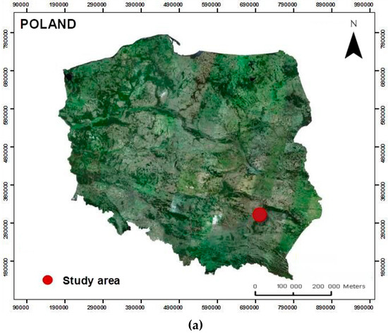
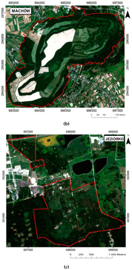
Figure 1.
The study areas: (a) overview map of Poland (aerial orthophoto 2012, coordinates system PL-1992), (b) Machów, and (c) Jeziórko—using Sentinel-2 (European Space Agency; ESA) red green blue (RGB) color composition (red line boundaries of study areas).
The post-mining sites and sulfurous soils are a unique example of anthropogenically-created conditions that are extremely difficult for natural succession and adaptation in conditions of severe environmental stress, which, at a time of environmental and climate change, [49,50] is important for the global situation and cognition in this field. The areas after sulfur mining are characterized by difficult conditions for reclamation and vegetation growth. In this case, especially for the Jeziórko sulfur mine, where the area was strongly chemically transformed because of the method of exploitation (underground melting, borehole method, and Frasch method), it is a very difficult area for the adaptation of vegetation (Figure 2) [51,52,53,54].
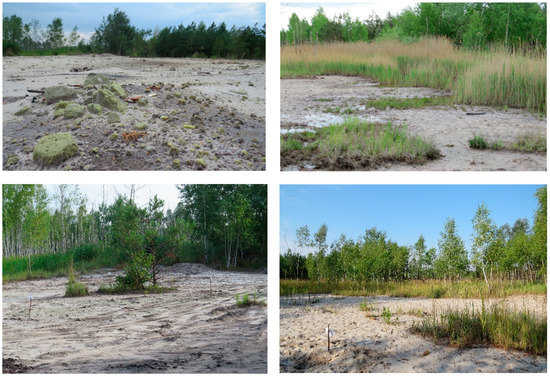
Figure 2.
The Jeziórko former sulfur mine area—vegetation adaptation (photo: J. Likus-Cieślik).
The former Machów sulfur mine and former Jeziórko sulfur mine are located in Southern Poland, near Tarnobrzeg. The region has an average annual temperature of 8.2 °C (–1.6 °C in January, and +18.7 °C in July), and the average annual precipitation ranges from 550 to 650 mm. The growing season lasts from 200 to 220 days per annum.
Sulfur was exploited from 1969 to 1992, using an open pit method in the Machów sulfur mine. During the open pit method of exploitation, large-scale underground excavations were created (about 560 ha; 80–100 m in depth) as well as above-level external excavations. During the exploitation period, 280 mln m3 of soil was moved and formed into a heap. The reclaimed heap area after sulfur mining occupied more than 880 ha. The reclamation process of Machów (from 1976 to 1998) included technical road building, landscaping, strengthening the slopes to minimize erosion, and plant cultivation on slopes and shelfs.
Sulfur mining in Jeziórko started in 1966, and the sulfur was exploited using a Frasch method (underground melting). The Jeziórko sulfur mine was the first and the biggest mine in Poland where sulfur was exploited using the Frasch method. Poland was the third-largest sulfur producer in the world using this method. The Frasch method was connected with a high geological and, in particular, chemical transformation of the land. The reclamation process (from 1993 to 2010) to forestry (about 216 ha) included removing the mine infrastructure (such as mine wells, pipelines, and access roads), improvements to hydrographic conditions and landscaping, pH neutralization of sulfurous and excessively acidic soils by liming (average 400–500 Mg ha-1 of sludge), fertilization (70 kg ha-1 P2O5, 60 kg ha-1 K2O), and grass sowing [52]. The next step of reclamation was area afforestation, mainly with one-year-old Scots pine seedlings (Pinus sylvestris L.) and an admixture of silver birch (Betula pendula Roth) and boreal oak (Quercus rubra L.) [51]. Of the more than 2000 ha previously occupied by the mine, over 700 hectares in total were reforested, of which 216.5 hectares, where this research was conducted, are currently managed by the Nowa Dęba Forest Inspectorate, State Forest National Forest Holding. Currently, the object is reforested mainly by scot pine and birch that are about 30 years old.
The study was prepared based on the following data sets:
- Sentinel-2 satellite image, 8 August 2016 (source: ESA): blue, green, and red (B,G,R) and NIR channels, spatial resolution of 10 m;
- Airborne laser scanning (ALS) point clouds, 2012 (source: Main Office of Surveying and Cartography, ISOK project—IT System for Protection of the Country, Poland), point cloud density of 6 pts/m2;
- Cadastral data, 2016 (source: Geoportal and webEWID portal).
Preliminary processing of the Sentinel-2 image was carried out using the SNAP 3.0.0 (ESA open-source software). Atmospheric correction was applied (Geomatica, PCI Geomatics). The main step was the Sentinel-2 image classification using the pixel-based supervised method (minimum distance algorithm; ILWIS). The classification was carried out by a photointerpretation key for Sentinel-2: RGB (red, green, and blue) and CIR (red, green, and NIR) composition, prepared during the field study (the training areas; area of interest; AOI) using a Spectra Precision GNSS receiver. The number of AOI was around 600 pixels for Machów and 350 for Jeziórko. The assessment of the classification results was carried out (ILWIS) by the Confusion Matrix function, which defined the average accuracy (AA), average reliability (AR), and overall accuracy (OA) based on the validation points. The validation points were chosen for each class from the test areas—not including the training areas. The number of validation points was around 2300 pixels for Machów and 600 for Jeziórko. The image classification result was generalized with the Boundary Clean and Majority Filter function (ArcGIS, Esri).
Airborne laser scanning point clouds were used to obtain precise information about the structure (2D and 3D) of the terrain and vegetation [41,42,43,44,45,46,47,48]. The processing of ALS point clouds was started by the following generated models: digital terrain model (DTM), digital surface model (DSM) and normalised DSM (nDSM = DSM-DTM), using GridSurface Create and Canopy Model functions in FUSION Version 3.50 (McGaughey, Pacific Northwest Research) [55]. The hillshade in grayscale (3D representation of the surface) with detailed profiles of the terrain were prepared based on the ALS data in ArcGIS (Esri).
Using FUSION software, the height of the vegetation was calculated (GridMetrics and CloudMetrics functions) as the value of the 95th percentile of the ALS point clouds relative altitude—a height below which is 95% of the whole analyzed points population. The standard deviation of the height and canopy cover (defined with values of 0%–100%) were also calculated. Visualizations of the vertical vegetation structure in the form of histograms were done using densitymetrics (FUSION)—information on the number of laser points reflected from the vegetation, in one-meter vertical intervals for the subsequent cells of the raster [55].
3. Results
The effects of processing the Sentinel-2 imagery and ALS point clouds are presented for the former sulfur mines of Machów and Jeziórko analysed areas. The first shows the LULC classes as a result of the image classification, then, the 2D and 3D parameters of the terrain and vegetation derived based on the ALS.
The morphometry characteristics of the terrain are presented as a DTM in the chosen color scale, from blue to red—for the lowest and highest values of the height above mean sea level (AMSL), respectively, and as a hillshade, in grayscale.
The parameters of vegetation, such as the height of vegetation (derived as 95th percentile), and the standard deviation of height and the canopy cover (value of 0%–100%), are presented as precise information about the spatial range of the vegetation and a visualization of the vertical vegetation structure. The parameters are presented as a raster map with a spatial resolution of 1.0 m.
3.1. Machów Sulfur Mine
The results of the Sentinel-2 image classification (2016), the LULC classification for the analysed area, are presented in Figure 3. The assessment parameters have the following values: AA = 95.13%, AR = 95.28%, and OA = 96.82% (Table 1) [11,56,57].
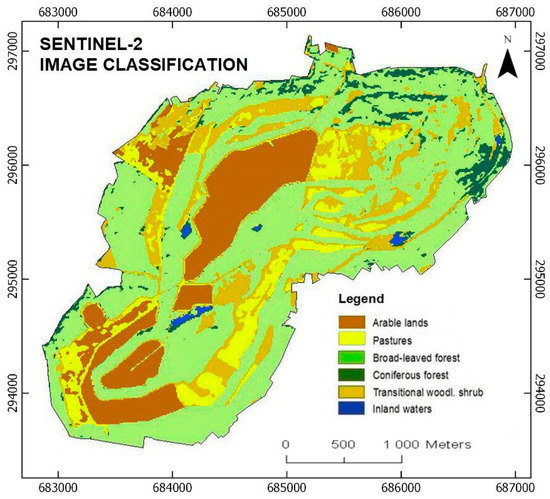
Figure 3.
Machów land use and land cover (LULC) classes—results of Sentinel-2 image classification.

Table 1.
Accuracy assessment for the Machów area—confusion matrix.
The most important LULC class for the Machów area is broad-leaved forest, but significant value is also given to agricultural lands, according to an agricultural and forest type of reclamation that was carried out at this former sulfur mine. Class broad-leaved forest is 41.4% of the analysed area, coniferous forest is 1.7%, transitional woodland shrub is 17.6%; arable lands is 26.5%, pastures is 12.2%, and waters is 0.6%.
The morphometry characteristics of the Machów terrain derived based on ALS point cloud processing are presented in Figure 4, using a digital terrain model (DTM), hillshade, and detailed profiles of the spoil dump. The 2D area of the spoil dump is 891.47 ha and the 3D volume of the masses is 324.79 mln m3 [58,59].
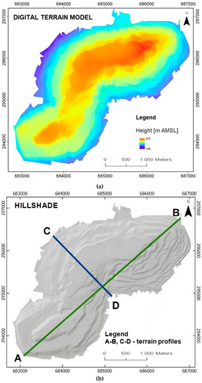
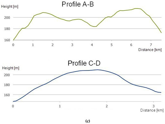
Figure 4.
The former sulfur mine of the Machów research area: (a) digital terrain model (DTM), (b) hillshade, and (c) terrain profiles. AMSL—above mean sea level.
The biggest total value of the LULC classes for the Machów analysed area are forested areas, so an important aim of the study was to derive detailed information about the spatial structure of the vegetation. This was done using ALS point clouds (2012) processing, as follows: height of vegetation (95th percentile), and standard deviation of the height and canopy cover (values of 0%−100%), presented in Figure 5 [58,59].
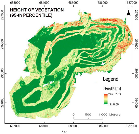
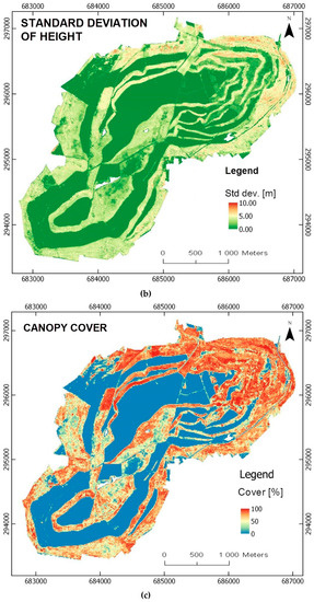
Figure 5.
Vegetation parameters for the Machów analysed area (ALS, 2012): (a) height of vegetation (95th percentile), (b) standard deviation of height, and (c) canopy cover (value of 0%–100%).
3.2. Jeziórko Sulfur Mine
The results of the Sentinel-2 image classification (2016), the LULC classification for the analysed area, are presented in Figure 6. The assessment parameters have the following values: AA = 86.17%, AR = 87.73%, and OA = 90.54% (Table 2) [11,56,57].
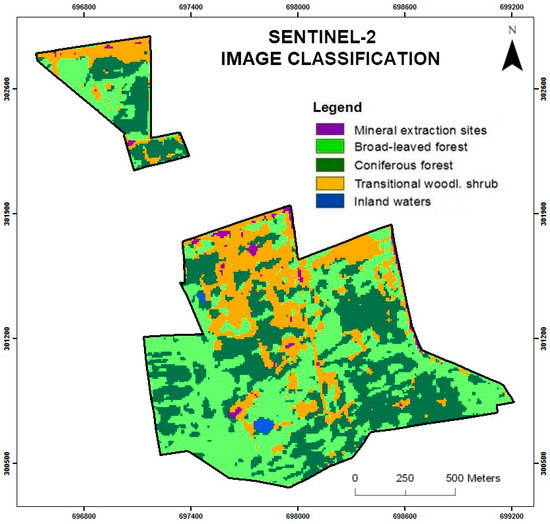
Figure 6.
Jeziórko LULC classes—results of the Sentinel-2 image classification.
Table 2.
Accuracy assessment for the Jeziórko area—confusion matrix.
The most dominant LULC classes for the Jeziórko area are forested areas. Broad-leaved forest has a value of 52.6% of the analysed area, coniferous forest has 24.6%, transitional woodland shrub has 18.3%. The total value of the forested areas is 95.5%. Other classes are mineral extraction sites, which has 1.2%, and waters, which has 3.4%.
The morphometry characteristics of the terrain, derived based on ALS point cloud processing, are presented in Figure 7. The area is rather flat, with the lowest place being 146 m AMSL and the highest place being 154 m AMSL. The visualization, in the form of hillshade (Figure 7b), shows the effect of the reclamation works carried out at the Jeziórko sulfur mine, such as roads, drainage ditches, and slopes [60].
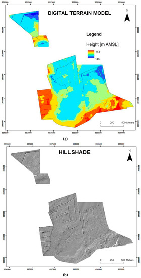
Figure 7.
The former sulfur mine Jeziórko research area: (a) DTM and (b) hillshade.
Detailed information about the spatial structure of the vegetation is presented in Figure 8 [11,60]. For the Jeziórko analysed area, we can observe the different stages of growth in the forested vegetation; for presentation, a different color scale than for Machow has been chosen to precisely show the differences in height vegetation. The parameters, derived based on ALS point clouds, showed precise information about the structure (3D) of the vegetation.
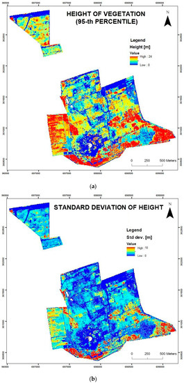
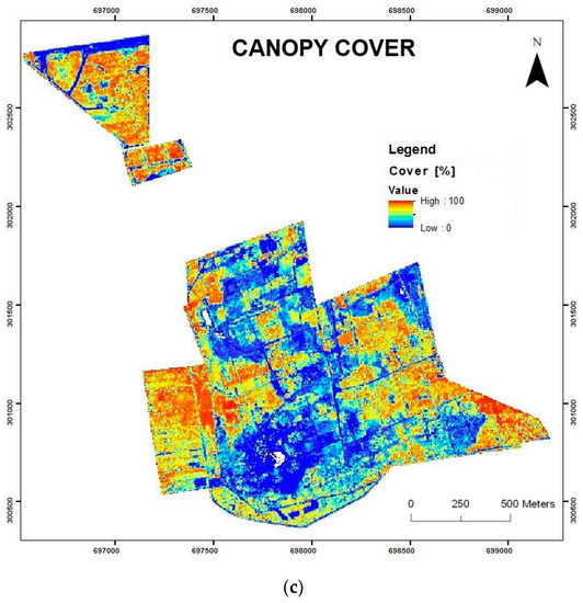
Figure 8.
Vegetation parameters for the Jeziórko analysed areas (ALS, 2012): (a) height of vegetation (95th percentile), (b) standard deviation of height, and (c) canopy cover (value of 0%–100%).
4. Discussion
The Jeziórko and Machów former sulfur mine areas are both examples of a dynamic increase in forested areas. For the LULC classes of broad-leaved forest, coniferous forest, and transitional woodland shrub, we can observe a dynamic change in growth. In previous studies [11,12,13], these areas showed an increase of spatial range in forested areas from the year 2000 to 2016, using image classification of Landsat 7 (2000), on-screen vectorization orthophoto (2009), Landsat 8 (2013), and the image classification of Sentinel-2 (2016).
The current LULC classes at the Machów and Jeziórko former sulfur mines, which are derived based on Sentinel-2 (2016, ESA) image processing, confirmed the applied type of reclamation in both areas. For Jeziórko, it was forestry, and for Machów, it was agroforestry [61,62,63,64]. The Jeziórko area is now almost fully covered by coniferous forest, broad-leaved forest, and transitional woodland shrub. At Machów, forested areas (broad-leaved forest and transitional woodland shrub) have the largest value, but there are also important agricultural lands—arable lands and pastures.
The total value of the LULC classes of coniferous forest, broad-leaved forest, and transitional woodland shrub in 2016 (Sentinel-2) get the following values: 95.5% for the Jeziórko analysed area, and 60.7% for Machów. For the Machów area, there are also important agricultural lands, as follows: arable lands and pastures, which covered a total of 38.7% of the analysed area according to the agroforestry type of reclamation for this area. According to the previous studies, based on Landsat 7 and Lansat 8 image processing [11,12,13], the increase in forested area for the period of time of 2000–2016 for Jeziórko was 13.3%, and for Machów was 14.6%. The forested areas in 2000 (Landsat 7) had a total value of 82.0% for Jeziórko, and 46.1% for Machów research area, and in 2013 (Landsat 8), Jeziórko was 93.8% and Machów was 50.5% [11,12,13].
Sentinel-2 images allowed for the correct identification of LULC classes (assessment above 90%). The results of the Sentinel-2 images’ classification in the study were satisfactory, indicating that it is reasonable to automate the process of the classification of land cover and for monitoring the increase in forested areas. According to papers using Sentinel images [31,32,33,34] and preparing terrain information for reclaimed areas using remote sensing data [7,8,9,65,66,67,68,69], research has confirmed the possibility of using Sentinel-2 images for LULC change detection and for the monitoring of vegetated areas in reclaimed areas.
Remote sensing materials and automated procedures of processing were indicated in research for finding the possibility of monitoring post-industrial areas, mainly in terms of the objectivity of the obtained results of land cover classification and the spatial structure (2D and 3D) of the vegetation. Analyses can be done at any time interval to analyze changes (4D analyses), according to the revisit time of the satellites and the ALS data availability—processing allows for obtaining a detailed LULC classification in a semi-automated way. It opens up possibilities in monitoring the progress of the growth spatial range of vegetation areas at any time interval, which is an important step in the assessment of the results from a carried-out reclamation. Fusing Sentinel-2 images and ALS point clouds gives possibilities for defining LULC changes and precise information about the spatial characteristics of vegetation on reclaimed areas by afforestation [11].
The parameters from the processed ALS point clouds in this research showed a variation in the height of the vegetation and canopy cover. It is important that we have precise information about the height of the vegetation at the Machów and Jezioróko analysed area. The automation of the processes for detecting and monitoring forested areas for the analysed areas is important and vital, because of the control process effects of the reclamation areas of former mines [9,11,70,71].
According to studies on Jeziórko and Machów, particularly for the Jeziórko area, an increase in forested areas was shown. For Jeziórko, a test site analysis of ALS point clouds suggests a significant variation in the height of the vegetation and canopy cover. Jeziórko was a heavily degraded area, in which there are still the remains of sulfur mines, and a graphical and spatial view of the vegetation structure shows differences in vegetation growth. This indicates an ongoing process of vegetation development, as an effect of the reclamation treatment for this area. Frasch’s method of sulfur exploitation caused geochemical, ground, and hydrology transformations [51,52].
The area after sulfur mining is characterized by difficult conditions for reclamation, so the monitoring of vegetation growth for this area is very important. An integration of the results of the Sentinel-2 image classification and LiDAR point clouds processing gives complementary and objective information about the distribution of the LULC classes. The spatial range and structure of the vegetation are precisely described. Geostatistical and geochemical analyses are used as complementary research.
To comprehensively assess the current state of the restored ecosystem after sulfur extraction, environmental components such as soil, surface water, the reaction of trees and herbaceous plants to a high sulfur concentration in soil, and plant nutrients have been examined. Soil contamination and plant reactions to contamination were assessed in two ways: spatially in a regular square grid sample points arrangement, covering above 200 ha of the reclaimed area [52], and in the reductionist approach of studying plots representing various categories of land plant cover [51,54]. The water chemistry was analyzed in the points located on the ponds and resivoirs in seasonal variations [53]. An examination of the abovementioned elements of the environment allowed for a comprehensive assessment of the state of the restored ecosystem.
LiDAR point cloud processing provides accurate information about the spatial and temporal distribution of LULC classes, and shows the spatial range and structure of the vegetation. Point clouds derived from laser scanning via an unmanned aerial vehicle (UAV) platform [72], or generated using, for example, a stereo-matching method from UAV imagery, could also be employed for such purposes [73,74,75]. Because of the use of LiDAR data—satellite (SLS), airborne (ALS), unmanned (ULS), or terrestrial (TLS) laser scanning—an exact assessment of the vegetation connected with the spatial distribution of the point cloud is possible. These indicators are often defined to meet the needs of planning and inventory, as well as for mapping plant associations. Geoinformation technologies show great potential for carrying out large area studies of the spatial vegetation structure.
An assessment of the LiDAR point clouds for the automation of the mapping range and structure of vegetation in forested areas is very important. In 2018, new satellite laser scanning missions began, such as global ecosystem dynamics investigation (GEDI) and ice, cloud, and land elevation Satellite-2 (ICESat-2), meaning that we can also test the possibilities of using data from these satellite LiDAR for detecting and monitoring forested areas. GEDI provides high-quality laser ranging observations of the Earth’s forests and topography. GEDI is mounted on the Japanese Experiment Module’s Exposed Facility (JEM-EF), and provides the first high-resolution observations of a forest vertical structure at a global scale [76]. ICESat-2 was launched in September 2018, and became the highest-resolution laser altimeter ever to be operated from space. The satellite is now measuring the height of the Earth’s surfaces in remarkable detail. The satellite collects detailed elevation measurements over tropical and temperate latitudes, providing a remarkable look at the heights of the land and ocean features. The advanced topographic laser altimeter system (ATLAS) on ICESat-2 measures the elevation by sending pulses of light to the Earth’s surface. It then measures, to within a billionth of a second, how long it takes individual photons to return to the sensor. Each dot on the visualization above represents a photon detected by ATLAS. Most of the dots in this “photon cloud” are clustered around a surface, whether a tree top, the ground, or waves in the ocean [77].
5. Conclusions
Post-mining areas are characterized by a dispersion in land cover classes and a diverse spatial structure of the formed vegetation. Monitoring the vegetation development is very significant for these areas. The aspect of monitoring the post-mining areas is directly connected with the constant need for precise geometric and attribute data, which can be obtained as a result of the application of remote sensing technologies and then integrated into a GIS system to generate new information with the application of spatial analyses 2D/3D.
This study showed a difference in the spatial range and structure of vegetation at the forested areas, which grows on the reclaimed areas’ former sulfur mines. The study highlighted the possibility of updating the LULC classes in terms of the identification and monitoring of reclaimed areas, with the processing of Sentinel-2 and LiDAR point clouds. In the presented study, the collected ALS point clouds show significant differences in the spatial structure of the vegetation. This diversity was visible in the surface size (2D) and vertical vegetation structure (3D). Differentiated vertical structures of vegetation indicate a long-lasting process of forest regrowth in reclaimed areas, using LiDAR point clouds allows for wider and more precise definitions of the spatial structure of vegetation. Furthermore, the application of the processed point clouds facilitates the objective and relatively accurate assessment of the spatial characteristics of the vegetation overgrowing in reclaimed areas, for example, its height above ground and canopy cover.
Author Contributions
Conceptualization, M.S., M.P.; methodology, M.S.; software, M.S.; validation, M.S.; formal analysis, M.S and J.L.-C.; visualization, M.S.; writing—original draft preparation, M.S.; M.P. and J.L.-C.; supervision, M.S.; M.P.; writing—review, M.S.; M.P. and J.L.-C. All authors have read and agreed to the published version of the manuscript.
Funding
This research was funded by the Ministry of Science and Higher Education of the Republic of Poland.
Conflicts of Interest
The authors declare no conflict of interest. The founding sponsors had no role in the design of the study; in the collection, analyses, or interpretation of data; in the writing of the manuscript, and in the decision to publish the results.
References
- Szostak, M.; Wężyk, P.; Tompalski, P. Aerial orthophoto and airborne laser scanning as monitoring tools for land cover dynamics: A case study from the Milicz Forest District (Poland). Pure Appl. Geophys. 2014, 171, 857–866. [Google Scholar] [CrossRef]
- Szostak, M.; Bednarski, A.; Wężyk, P. Monitoring of secondary forest succession on abandoned farmland using LiDAR point clouds. Geod. Cartogr. 2018, 67, 305–319. [Google Scholar] [CrossRef]
- Susyan, E.A.; Wirth, S.; Ananyeva, N.D.; Stolnikova, E.V. Forest succession on abandoned arable soils in European Russia − Impacts on microbial biomass, fungal-bacterial ratio, and basal CO2 respiration activity. Eur. J. Soil Biol. 2011, 47, 169–174. [Google Scholar] [CrossRef]
- Bork, E.; Su, J. Integrating LIDAR data and multispectral imagery for enhanced classification of rangeland vegetation: A meta-analysis. Remote Sens. Environ. 2007, 111, 11–24. [Google Scholar] [CrossRef]
- Lasanta, T.; Arnáez, J.; Pascual, N.; Ruiz-Flaño, P.; Errea, M.P.; Lana-Renault, N. Space–time process and drivers of land abandonment in Europe. Catena 2017, 149, 810–823. [Google Scholar] [CrossRef]
- Singh, K.; Vogler, J.; Shoemaker, D.; Meentemeyer, R. LiDAR-Landsat data fusion for large-area assessment of urban land cover: Balancing spatial resolution, data volume, and mapping accuracy. ISPRS J. Photogramm. Remote Sens. 2012, 74, 110–121. [Google Scholar] [CrossRef]
- Koska, B.; Jirkab, V.; Urbana, R.; Kremena, T.; Hesslerovab, P.; Jona, J.; Pospisila, J.; Fogl, M. Suitability, characteristics, and comparison of an airship UAV with lidar for middle size area mapping. Int. J. Remote Sens. 2017, 38, 2973–2990. [Google Scholar] [CrossRef]
- Pitblado, J.R.; Amiro, B.D. Landsat Mapping of the Industrially Disturbed Vegetation Communities of Sudbury, Canada. Can. J. Remote Sens. 2014, 8, 17–28. [Google Scholar] [CrossRef]
- Urban, R.; Koska, B.; Moudry, V.; Solsky, M. Terrain of post mining site from airship lidar. In Proceedings of the 16th International Multidisciplinary Scientific GeoConference, SGEM2016, Albena, Bulgaria, 30 June–6 July 2016; Volume 2, pp. 577–584. [Google Scholar] [CrossRef]
- Wang, J.; Wei, Z.; Wang, O. Evaluating the eco-environment benefit of land reclamation in the dump of an opencast coal mine. Chem. Ecol. 2017, 33, 607–624. [Google Scholar] [CrossRef]
- Szostak, M.; Knapik, K.; Likus-Cieślik, J.; Wężyk, P.; Pietrzykowski, M. Fusing Sentinel-2 imagery and ALS Point Clouds for Defining the LULC Changes Ongoing on Reclaimed Areas by Afforestation. Sustainability 2019, 11, 1251. [Google Scholar] [CrossRef]
- Szostak, M.; Likus-Cieślik, J.; Knapik, K.; Wężyk, P.; Pietrzykowski, M. Monitoring the spatial range of forested areas in the reclaimed sites using Sentinel−2 images. Sylwan 2019, 163, 55–61. [Google Scholar]
- Szostak, M.; Wężyk, P.; Hawryło, P.; Pietrzykowski, M. The analysis of spatial and temporal changes of land cover and land use in the reclaimed areas with the application of airborne orthophotomaps and LANDSAT images. Geod. Cartogr. 2015, 64, 75–86. [Google Scholar] [CrossRef]
- Wężyk, P.; Szostak, M.; Krzaklewski, W.; Pająk, M.; Pierzchalski, M.; Szwed, P.; Hawryło, P.; Ratajczak, M. Landscape monitoring of post-industrial areas using LiDAR and GIS technology. Geod. Cartogr. 2015, 64, 125–137. [Google Scholar] [CrossRef]
- Yuan, Y.; Zhao, Z.; Niu, S.; Li, X.; Wang, Y.; Bai, Z. Reclamation promotes the succession of the soil and vegetation in opencast coal mine: A case study from Robinia pseudoacacia reclaimed forests, Pingshuo mine, China. Catena 2018, 165, 72–79. [Google Scholar] [CrossRef]
- Krzaklewski, W.; Pietrzykowski, M. Selected physicochemical properties of zinc and lead ore tailings and their biological stabilisation. Water Air Soil Pollut. 2002, 141, 125–142. [Google Scholar] [CrossRef]
- Krzaklewski, W.; Barszcz, J.; Małek, S.; Kozioł, K.; Pietrzykowski, M. Contamination of forest soils in the vicinity of the sedimentation pond after zinc and lead ore flotation (in the region of Olkusz, Southern Poland). Water Air Soil Pollut. 2004, 159, 151–164. [Google Scholar] [CrossRef]
- Kowalik, S. Właściwości chemiczne gleb industrioziemnych użytkowanych rolniczo i leśnie na zrekultywowanym zwałowisku Kopalni Siarki Machów. Rocz. Glebozn. 2004, 55, 239–249. [Google Scholar]
- Florentine, S.K.; Gardner, J.; Graz, F.P.; Moloney, S. Plant recruitment and survival as indicators of ecological restoration success in abandoned pasture land in Nurcoung, Victoria, Australia. Ecol. Process. 2013, 2, 34. [Google Scholar] [CrossRef]
- Hüttl, R.F.; Weber, E. Forest ecosystem development in post-mining landscapes, a case study of the Lusatian lignite district. Naturwissenschaften 2001, 88, 322–329. [Google Scholar]
- Pietrzykowski, M. Soil and plant communities development and ecological effectiveness of reclamation on a sand mine cast. J. For. Sci. 2008, 54. [Google Scholar] [CrossRef]
- Favas, P.J.C.; Martino, L.E.; Prasad, M.N.V. Abandoned Mine Land Reclamation—Challenges and Opportunities (Holistic Approach). In Bio-Geotechnologies for Mine Site Rehabilitation; Prasad, M.N., Favas, P.J.C., Maiti, S.K., Eds.; Elsevier: Amsterdam, The Netherlands, 2018; pp. 3–31. [Google Scholar]
- Alvarenga, P.; Clemente, R.; Garbisu, C.; Becerril, J.M. Indicators for monitoring mine site rehabilitation. In Bio-Geotechnologies for Mine Site Rehabilitation; Prasad, M.N., Favas, P.J.C., Maiti, S.K., Eds.; Elsevier: Amsterdam, The Netherlands, 2018; pp. 49–66. [Google Scholar]
- Gatica-Saavedra, P.; Echeverría, C.; Nelson, C.R. Ecological indicators for assessing ecological success of forest restoration: A world review. Restor. Ecol. 2017, 25, 850–857. [Google Scholar] [CrossRef]
- Borisev, M.; Pejevic, S.; Nikolic, N.; Pilipovic, A.; Arsenov, D.; Zupunski, M. Mine site restoration using silvicultural approach. In Bio-Geotechnologies for Mine Site Rehabilitation; Prasad, M.N., Favas, P.J.C., Maiti, S.K., Eds.; Elsevier: Amsterdam, The Netherlands, 2018; pp. 115–127. [Google Scholar]
- Pietrzykowski, M.; Krzaklewski, W. An assessment of energy efficiency in reclamation to forest. Ecol. Eng. 2007, 30, 341–348. [Google Scholar] [CrossRef]
- Huang, L.; Zhang, P.; Hu, Y.; Zhao, Y. Vegetation and soil restoration in refuse dumps from open pit coal mines. Ecol. Eng. 2016, 94, 638–646. [Google Scholar] [CrossRef]
- Bradshaw, A.D.; Hüttl, R. Future Minesite Restoration Involves a Broader Approach. Ecol. Eng. 2001, 17, 87–90. [Google Scholar] [CrossRef]
- Pietrzykowski, M. Tree species selection and reaction to mine soil reconstructed at reforested post-mine sites: Central and eastern European experiences. Ecol. Eng. 2019, 10. [Google Scholar] [CrossRef]
- Pietrzykowski, M. Soil quality index as a tool for Scots pine (Pinus ylvestris) monoculture conversion planning on afforested, reclaimed mine land. J. For. Res. 2014, 25, 63–74. [Google Scholar] [CrossRef]
- Szostak, M.; Hawryło, P.; Piela, D. Using of Sentinel-2 images for automation of the forest succession detection. Eur. J. Remote Sens. 2018, 51, 142–149. [Google Scholar] [CrossRef]
- Forkuor, G.; Dimobe, K.; Serme, I.; Tondoh, J.E. Landsat-8 vs. Sentinel-2: Examining the added value of Sentinel-2’s red-edge bands to land-use and land-cover mapping in Burkina Faso. Gisci. Remote Sens. 2018, 55, 331–354. [Google Scholar] [CrossRef]
- Marangoz, A.M.; Sekertekin, A.; Akçin, H. Analysis of land use land cover classification results derived from Sentinel-2 image. In Proceedings of the 17th International Multidisciplinary Scientific GeoConference Surveying Geology and Mining Ecology Management, SGEM2017, Vienna, Austria, 27–29 November 2017; pp. 25–32. [Google Scholar]
- Sekertekin, A.; Marangoz, A.M.; Akcin, H. Pixel-based classification analysis of land use land cover using Sentinel-2 and Landsat-8 data. Int. Arch. Photogramm. Remote Sens. Spat. Inf. Sci. 2017, 42, 91–93. [Google Scholar] [CrossRef]
- van Ewijk, K.Y.; Treitz, P.M.; Scott, N.A. Characterizing forest succession in central Ontario using lidar-derived indices. Photogramm. Eng. Remote Sens. 2011, 77, 261–269. [Google Scholar] [CrossRef]
- Falkowski, M.; Jeffrey, S.; Evans, J.; Martinuzzi, S.; Gessler, P.; Hudak, A. Characterizing forest succession with lidar data: An evaluation for the Inland Northwest, USA. Remote Sens. Environ. 2009, 113, 946–956. [Google Scholar] [CrossRef]
- Kolecka, N.; Kozak, J.; Kaim, D.; Dobosz, M.; Ginzler, C.; Psomas, A. Mapping secondary forest succession on abandoned agricultural land with LiDAR point clouds and terrestrial photography. Remote Sens. 2015, 7, 8300–8322. [Google Scholar] [CrossRef]
- Kolecka, N. Height of Successional Vegetation Indicates Moment of Agricultural Land Abandonment. Remote Sens. 2018, 10, 1568. [Google Scholar] [CrossRef]
- Szostak, M.; Wężyk, P.; Király, G.; Hawryło, P.; Bednarski, A. Automation in the assessment of forest succession dynamics using airborne laser scanning data. In Proceedings of the 18th International Multidisciplinary Scientific GeoConference Surveying Geology and Mining Ecology Management SGEM 2018, Albena, Bulgaria, 30 June–9 July 2018; Volume 18, pp. 41–48. [Google Scholar] [CrossRef]
- Axelsson, P. DEM generation from laser scanner data using adaptive TIN models. Int. Arch. Photogramm. Remote Sens. 2000, 33, 203–210. [Google Scholar]
- Andersen, H.E.; Reutebuch, S.E.; McGaughey, R.J. A rigorous assessment of tree height measurements obtained using airborne lidar and conventional field methods. Can. J. Remote Sens. 2006, 32, 355–366. [Google Scholar] [CrossRef]
- Hyyppä, J.; Hyyppä, H.; Litkey, P.; Yu, X.; Haggrén, H.; Rönnholm, P.; Pyysalo, U.; Pitkanen, J.; Maltamo, M. Algorithms and methods of airborne laser-scanning for forest measurements. Int. Arch. Photogramm. Remote Sens. Spat. Inf. Sci. 2004, 8, 82–89. [Google Scholar]
- Maier, B.; Tiede, D.; Dorren, L. Characterising mountain forest structure using landscape metrics on LIDAR-based canopy surface models. In Lecture Notes in Geoinformation and Cartography, Object-Based Image Analysis; Springer: Berlin/Heidelberg, Germany, 2008; pp. 625–643. [Google Scholar] [CrossRef]
- McGaughey, R.J.; Carson, W.; Reutebuch, S.; Andersen, H.E. Direct measurement of individual tree characteristics from lidar data. In Proceedings of the Annual ASPRS Conference. Denver. American Society of Photogrammetry and Remote Sensing, Denver, CO, USA, 23–28 May 2004. [Google Scholar]
- Naesset, E. Predicting forest stand characteristics with airborne scanning laser using a practical two-stage procedure and field data. Remote Sens. Environ. 2002, 80, 80–99. [Google Scholar] [CrossRef]
- Naesset, E.; Okland, T. Estimating tree height and tree crown properties using airborne scanning laser in a boreal nature reserve. Remote Sens. Environ. 2002, 79, 105–115. [Google Scholar] [CrossRef]
- Wężyk, P.; Szostak, M.; Tompalski, P.; Zajączkowski, G. The role of Airborne Laser Scanning in updating and revision of GIS databases − A case study in the Polish State Forest (Chojna District). In Proceedings of the Silvilaser, 10th International Conference on LiDAR Applications for Assessing Forest Ecosystems, Freiburg, Germany, 14th–17th September 2010. [Google Scholar]
- Wężyk, P.; Tompalski, P.; Szostak, M.; Glista, M.; Pierzchalski, M. Describing the selected canopy layer parameters of the Scots pine stands using ALS data. In Proceedings of the SiliviLaser 2008: 8th International Conference on LiDAR Applications in Forest Assessment and Inventory, Edinburgh, UK, 17–19 September 2008; pp. 636–645. [Google Scholar]
- Katzur, J.; Haubold-Rosar, M. Amelioration and reforestation of sulfurous mine soils in Lusatia (Eastern Germany). Water Air Soil Pollut. 1996, 91, 17–32. [Google Scholar] [CrossRef]
- Courtney, R.; Pietrzykowski, M. Soil Quality Indices for Evaluation of Acid Mine Spoil. BioGeotechnol. Mine Site Rehabil. 2018. [Google Scholar] [CrossRef]
- Likus-Cieślik, J.; Pietrzykowski, M.; Śliwińska-Siuśta, M.; Krzaklewski, W.; Szostak, M. Preliminary assessment of soil sulfur contamination and vegetation characteristic in the vicinity of former boreholes on afforested post-mine site Jeziorko. Geol. Geophys. Environ. 2015, 41, 371–380. [Google Scholar] [CrossRef]
- Likus-Cieślik, J.; Pietrzykowski, M.; Szostak, M.; Szulczewski, M. Spatial distribution and concentration of sulfur in relation to vegetation cover and soil properties on a reclaimed sulfur mine site (Southern Poland). Environ. Monit. Assess. 2017, 189, 1–12. [Google Scholar] [CrossRef] [PubMed]
- Likus-Cieślik, J.; Smoliński, A.; Pietrzykowski, M.; Bąk, A. Sulfur contamination impact on seasonal and surface waterchemistry on a reforested area of a former sulfur mine. Land Degrad. Dev. 2019, 30, 212–225. [Google Scholar] [CrossRef]
- Pietrzykowski, M.; Likus-Cieślik, J. Comprehensive Study of Reclaimed Soil, Plant, and Water Chemistry Relationships in Highly S-Contaminated Post Sulfur Mine Site Jeziórko (Southern Poland). Sustainability 2018, 10, 2442. [Google Scholar] [CrossRef]
- McGaughey, R.J. Fusion/ldv: Software for Lidar Data Analysis and Visualization, US Department of Agriculture; Forest Service, Pacific Northwest Research Station: Seattle, WA, USA, 2012.
- Knapik, K. Determination of Land Use and Land Cover Classes Former Sulfur Mine “Jeziórko” and “Machów” Based on Sentinel-2A Satellite Images. Bachelor’s Thesis, University of Agriculture in Krakow, Kraków, Poland, 2017. [Google Scholar]
- Szostak, M.; Likus-Cieślik, J.; Knapik, K.; Wężyk, P.; Pietrzykowski, M. Analysis of land use and land cover classes for the afforested post-mine site using Sentinel-2 images. In Proceedings of the 18th International Multidisciplinary Scientific GeoConference Surveying Geology and Mining Ecology Management SGEM 2018, Albena, Bulgaria, 30 June–9 July 2018; Volume 18, pp. 41–48. [Google Scholar] [CrossRef]
- Furgała, T. Morphometric Characteristics of Dumping Area the Former Sulfur Mine “Machów” and Spatial Structure of Vegetation Determinien Based on Airborne Laser Scanning Point Clouds. Master’s Thesis, University of Agriculture in Krakow, Krakow, Poland, 2019. [Google Scholar]
- Szostak, M.; Furgała, T.; Knapik, K. Landscape monitoring of post-industrial area using LiDAR point clouds and Sentinel-2 images. In Proceedings of the 19th International Multidisciplinary Scientific Geoconference SGEM Conference Proceedings, SGEM2019, Albena, Bulgaria, 28 June–7 July 2019; pp. 431–438. [Google Scholar] [CrossRef]
- Knapik, K. Determination of Spatial Structure of Vegetaion for the Reclaimed Former Sulfur Mine “Jeziórko” Based on Airborne Laser Scanning Point Clouds. Master’s Thesis, University of Agriculture in Krakow, Kraków, Poland, 2019. [Google Scholar]
- Gołda, T. Rekultywacja; Uczelniane Wydawnictwa Naukowo−Dydaktyczne AGH: Kraków, Poland, 2005. [Google Scholar]
- Gołda, T.; Haładus, A.; Kulma, R. Geosozologiczne skutki likwidacji kopalń siarki w 19 rejonie Tarnobrzega. Inżynieria Środowiska 2005, 10, 70–72. [Google Scholar]
- Hajdo, S.; Klich, J.; Galiniak, G. Ekologiczne i technologiczne osiągnięcia w 40−letniej historii górnictwa otworowego siarki w Polsce. Górnictwo Geoinżynieria 2007, 31, 199–215. [Google Scholar]
- Pietrzykowski, M.; Krzaklewski, W. Reclamation of mine lands in Poland. In Bio-Geotechnologies for Mine Site Rehabilitation; Prasad, M.N.V., de Campos Favas, P.J., Maiti, S.K., Eds.; Elsevier: Amsterdam, The Netherlands; Oxford-Cambridge, UK, 2017; Volume 27, pp. 493–513. [Google Scholar]
- Townsend, P.; Helmers, D.; Kingdon, C.; McNeil, B.; de Beurs, K.; Eshleman, K. Changes in the extent of surface mining and reclamation in the Central Appalachians detected using a 1976–2006 LANDSAT time series. Remote Sens. Environ. 2009, 113, 62–72. [Google Scholar] [CrossRef]
- Chowdhury, S.; Chao, D.K.; Shipman, T.C.; Wulder, M.A. Utilization of Landsat data to quantify land-use and land-cover changes related to oil and gas activities in West-Central Alberta from 2005 to 2013. Gisci. Remote Sens. 2017, 54, 700–720. [Google Scholar] [CrossRef]
- Farrand, W.H.; Harsanyi, J.C. Mapping The Distribution Of Mine Tailings In The Coeur D’alene River Valley, Idaho, Through The Use Of A Constrained Energy Minimization Technique. Remote Sens. Environ. 1997, 59, 64–76. [Google Scholar] [CrossRef]
- Pouliot, D.; Latifovic, R. Land Change Attribution Based on Landsat Time Series and Integration of Ancillary Disturbance Data in the Athabasca Oil Sands Region of Canada. Gisci. Remote Sens. 2016, 53, 382–401. [Google Scholar] [CrossRef]
- Powers, R.P.; Hermosilla, T.; Coops, N.C.; Chen, G. Remote Sensing and Object-Based Techniques for Mapping Fine-Scale Industrial Disturbances. Int. J. Appl. Earth Obs. Geoinf. 2015, 34, 51–57. [Google Scholar] [CrossRef]
- Szostak, M.; Wężyk, P.; Pająk, M.; Hawryło, P.; Lisańczuk, M. Determination of the spatial structure of vegetation on the repository of the mine Fryderyk in Tarnowskie Góry, based on airborne laser scanning from the ISOK project and digital orthophotomaps. Geod. Cartogr. 2015, 64, 87–99. [Google Scholar] [CrossRef]
- Moudrý, V.; Gdulová, K.; Fogl, M.; Klápště, P.; Urban, R.; Komárek, J.; Moudrá, L.; Štroner, M.; Barták, V.; Solský, M. Comparison of leaf-off and leaf-on combined UAV imagery and airborne LiDAR for assessment of a post-mining site terrain and vegetation structure: Prospects for monitoring hazards and restoration success. Appl. Geogr. 2019, 104, 32–41. [Google Scholar] [CrossRef]
- Ostrowski, W.; Górski, K.; Pilarska, M.; Salach, A.; Bakuła, K. Comparison of the laser scanning solutions for the unmanned aerial vehicles. Arch. Photogramm. Cartogr. Remote Sens. 2017, 29, 101–123. [Google Scholar] [CrossRef]
- Vastaranta, M.; Wulder, M.A.; White, J.C.; Pekkarinen, A.; Tuominen, S.; Ginzler, C.; Kankare, V.; Holopainen, M.; Hyyppä, J.; Hyyppä, H. Airborne laser scanning and digital stereo imagery measures of forest structure: Comparative results and implications to forest mapping and inventory update. Can. J. Remote Sens. 2013, 39, 382–395. [Google Scholar] [CrossRef]
- White, J.; Stepper, C.; Tompalski, P.; Coops, N.; Wulder, M. Comparing ALS and Image-Based Point Cloud Metrics and Modelled Forest Inventory Attributes in Complex Coastal Forest Environment. Forests 2015, 6, 3704–3732. [Google Scholar] [CrossRef]
- White, J.; Wulder, M.; Vastaranta, M.; Coops, N.; Pitt, D.; Woods, M. The Utility of Image-Based Point Clouds for Forest Inventory: A Comparison with Airborne Laser Scanning. Forests 2013, 4, 518–536. [Google Scholar] [CrossRef]
- National Aeronautics and Space Administration. 2019. GEDI. Available online: https://www.nasa.gov/mission_pages/station/research/experiments/2905.html (accessed on 1 December 2019).
- National Aeronautics and Space Administration. 2019. ISAT-2. Available online: https://earthobservatory.nasa.gov/images/144450/icesat-2-sees-the-trees-in-mexico (accessed on 1 December 2019).


© 2020 by the authors. Licensee MDPI, Basel, Switzerland. This article is an open access article distributed under the terms and conditions of the Creative Commons Attribution (CC BY) license (http://creativecommons.org/licenses/by/4.0/).