Inter-Calibration of Passive Microwave Satellite Brightness Temperatures Observed by F13 SSM/I and F17 SSMIS for the Retrieval of Snow Depth on Arctic First-Year Sea Ice


Abstract
1. Introduction
2. Study area and Data
2.1. Region of Interest
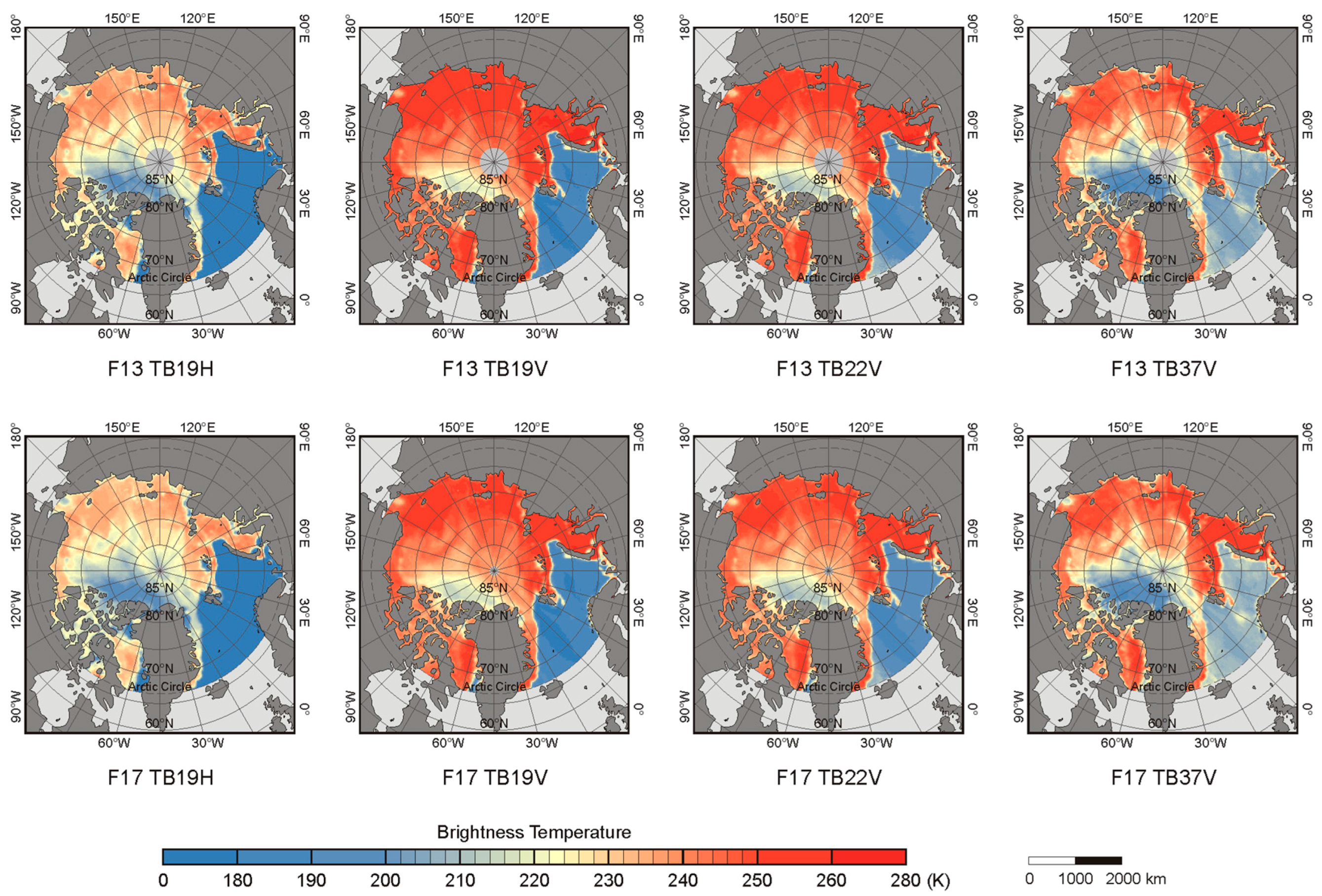
2.2. SSM/I and SSMIS Data
2.3. OIB Snow Depth Data
3. Methods
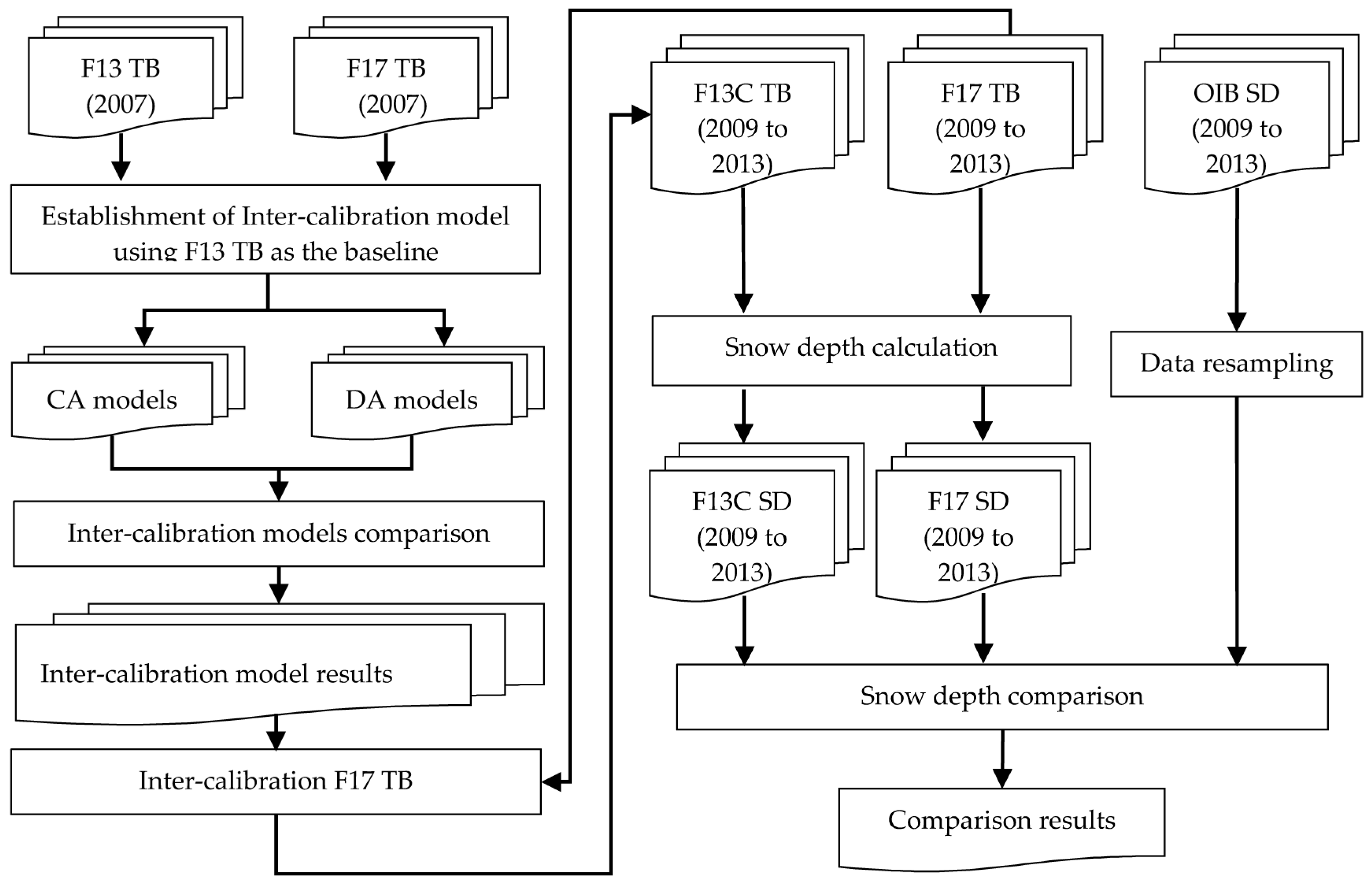
3.1. Flow of Data Processing
3.2. F13 and F17 Data Inter-Calibration
3.3. Snow Depth Algorithm
3.4. Snow Depth Comparison
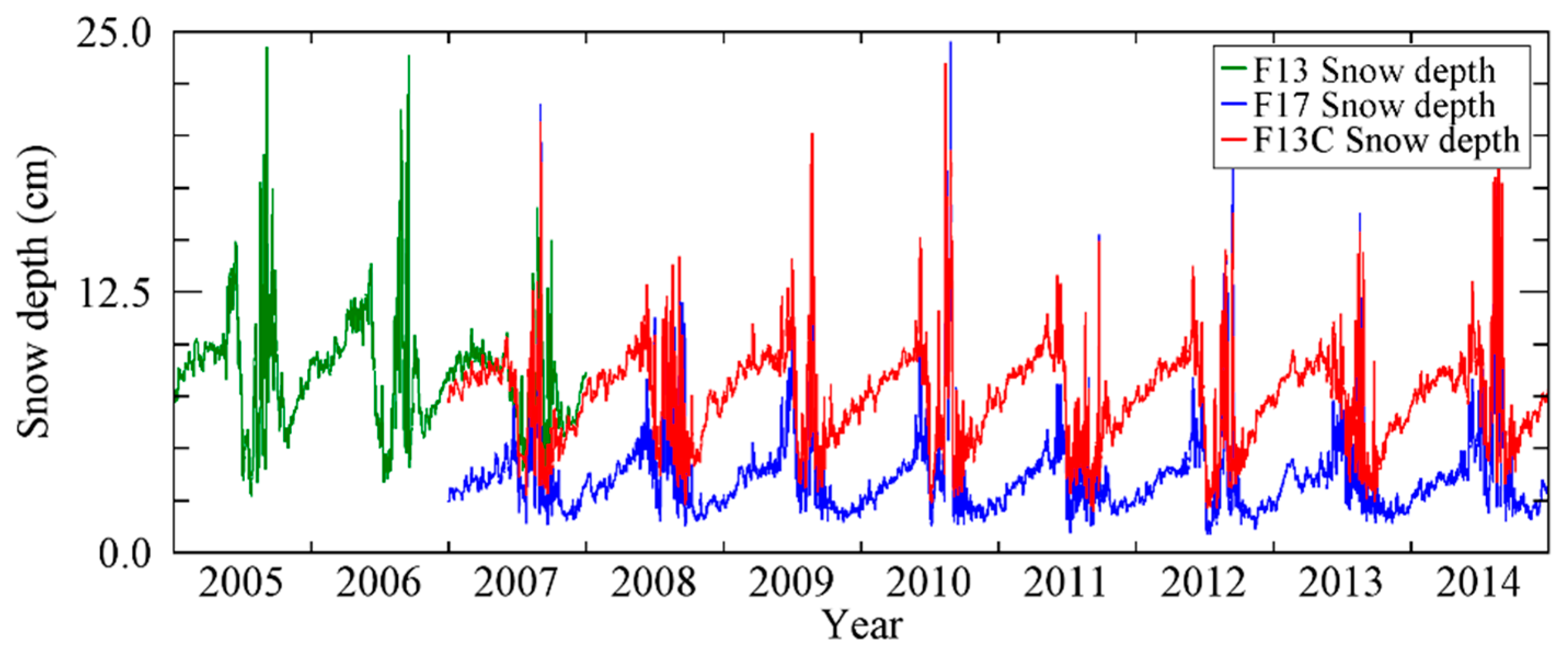
4. Results
4.1. Inter-Calibration Models
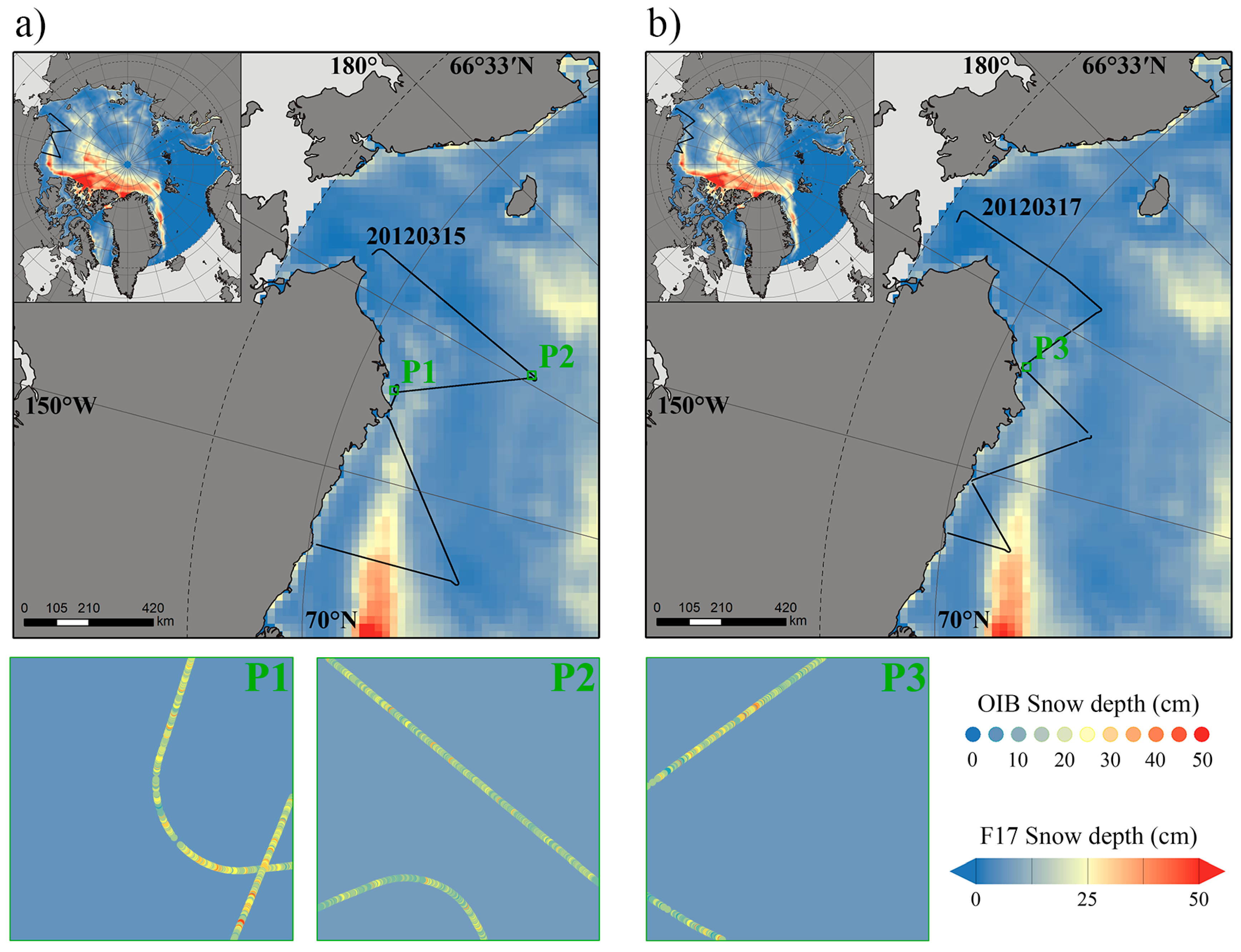
4.2. OIB Snow Depth Resampling in 25 km Pixel
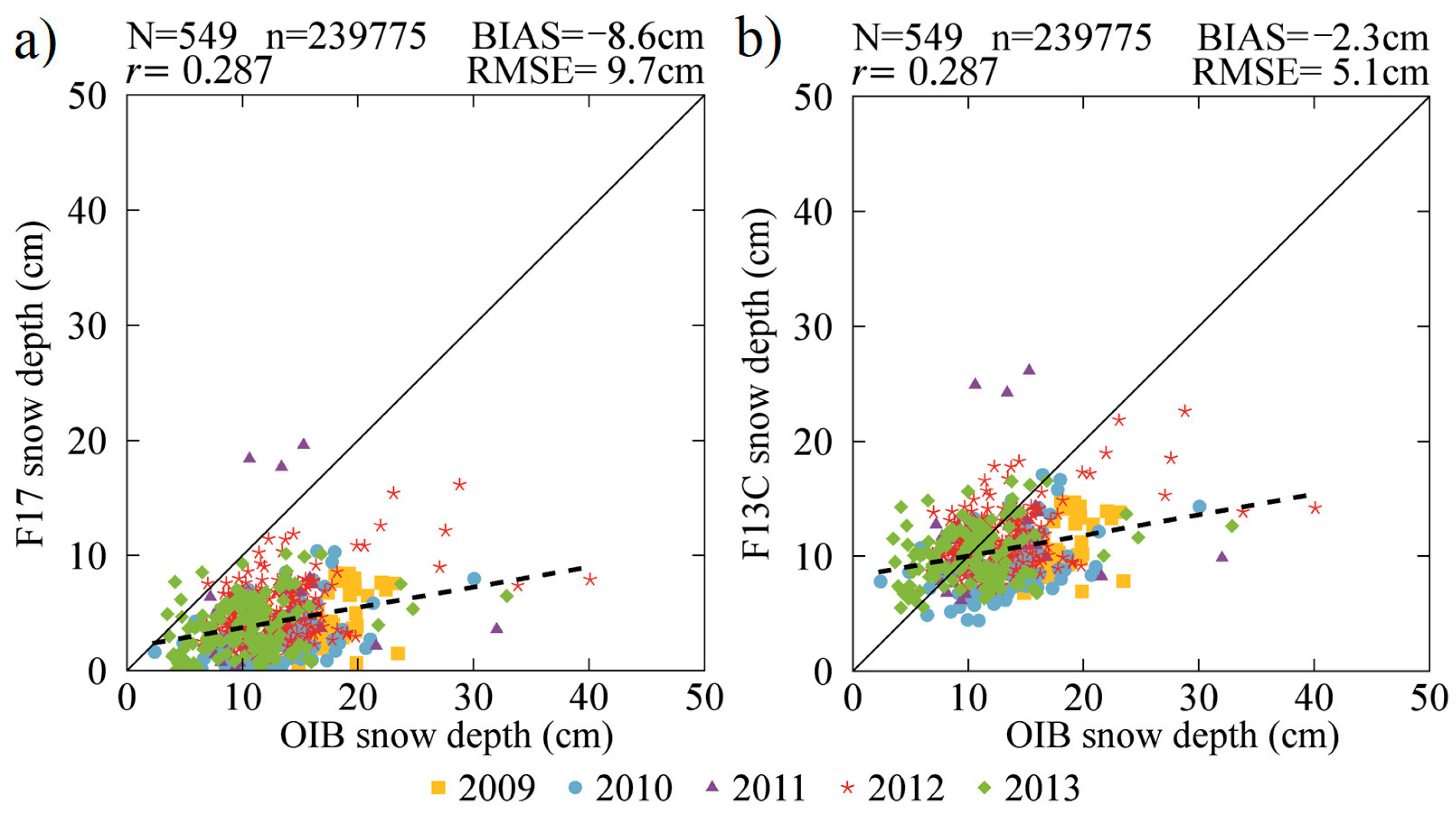
4.3. Comparison with OIB Snow Depth
5. Discussion
6. Conclusions
Acknowledgments
Author Contributions
Conflicts of Interest
References
- Stocker, T.F.; Qin, D.; Plattner, G.-K.; Tignor, M.; Allen, S.K.; Boschung, J.; Nauels, A.; Xia, Y.; Bex, B.; Midgley, B. IPCC, 2013: Climate Change 2013: The Physical Science Basis. Contribution of Working Group I to the Fifth Assessment Report of the Intergovernmental Panel on Climate Change; Cambridge University Press: Cambridge, UK, 2013. [Google Scholar]
- Meier, W.N.; Hovelsrud, G.K.; Oort, B.E.H.; Key, J.R.; Kovacs, K.M.; Michel, C.; Haas, C.; Granskog, M.A.; Gerland, S.; Perovich, D.K. Arctic sea ice in transformation: A review of recent observed changes and impacts on biology and human activity. Rev. Geophys. 2015, 52, 185–217. [Google Scholar] [CrossRef]
- Stroeve, J.C.; Serreze, M.C.; Holland, M.M.; Kay, J.E.; Malanik, J.; Barrett, A.P. The Arctic’s rapidly shrinking sea ice cover: A research synthesis. Clim. Chang. 2012, 110, 1005–1027. [Google Scholar] [CrossRef]
- Bhatt, U.S.; Walker, D.A.; Walsh, J.E.; Carmack, E.C.; Frey, K.E.; Meier, W.N.; Mo—Ore, S.E.; Parmentier, F.J.W.; Post, E.; Romanovsky, V.E. Implications of Arctic Sea Ice Decline for the Earth System. Annu. Rev. Environ. Resour. 2014, 39, 57–89. [Google Scholar] [CrossRef]
- Nghiem, S.; Rigor, I.; Perovich, D.; Clemente-Colón, P.; Weatherly, J.; Neumann, G. Rapid reduction of Arctic perennial sea ice. Geophys. Res. Lett. 2007, 34. [Google Scholar] [CrossRef]
- Maslanik, J.; Stroeve, J.; Fowler, C.; Emery, W. Distribution and trends in Arctic sea ice age through spring 2011. Geophys. Res. Lett. 2011, 38. [Google Scholar] [CrossRef]
- Dietz, A.J.; Kuenzer, C.; Gessner, U.; Dech, S. Remote sensing of snow—A review of available methods. Int. J. Remote Sens. 2012, 33, 4094–4134. [Google Scholar] [CrossRef]
- Markus, T.; Cavalieri, D.J. Snow Depth Distribution Over Sea Ice in the Southern Ocean from Satellite Passive Microwave Data; American Geophysical Union: Washington, DC, USA, 1998; Volume 74, pp. 19–39. [Google Scholar]
- Perovich, D.K.; Polashenski, C. Albedo evolution of seasonal Arctic sea ice. Geophys. Res. Lett. 2012, 39. [Google Scholar] [CrossRef]
- Brucker, L.; Markus, T. Arctic-scale assessment of satellite passive microwave-derived snow depth on sea ice using Operation IceBridge airborne data. J. Geophys. Res. Oceans 2013, 118, 2892–2905. [Google Scholar] [CrossRef]
- Webster, M.A.; Rigor, I.G.; Nghiem, S.V.; Kurtz, N.T.; Farrell, S.L.; Perovich, D.K.; Sturm, M. Interdecadal changes in snow depth on Arctic sea ice. J. Geophys. Res. Oceans 2014, 119, 5395–5406. [Google Scholar] [CrossRef]
- Kern, S.; Khvorostovsky, K.; Skourup, H.; Rinne, E.; Parsakhoo, Z.; Djepa, V.; Wadhams, P.; Sandven, S. The impact of snow depth, snow density and ice density on sea ice thickness retrieval from satellite radar altimetry: Results from the ESA-CCI Sea Ice ECV Project Round Robin Exercise. Cryosphere 2015, 9, 37–52. [Google Scholar] [CrossRef]
- Giles, K.; Laxon, S.; Wingham, D.; Wallis, D.; Krabill, W.; Leuschen, C.; McAdoo, D.; Manizade, S.; Raney, R. Combined airborne laser and radar altimeter measurements over the Fram Strait in May 2002. Remote Sens. Environ. 2007, 111, 182–194. [Google Scholar] [CrossRef]
- Justice, C.; Belward, A.; Morisette, J.; Lewis, P.; Privette, J.; Baret, F. Developments in the ‘validation’ of satellite sensor products for the study of the land surface. Int. J. Remote Sens. 2000, 21, 3383–3390. [Google Scholar] [CrossRef]
- Chander, G.; Hewison, T.J.; Fox, N.; Wu, X.; Xiong, X.; Blackwell, W.J. Overview of intercalibration of satellite instruments. IEEE Trans. Geosci. Remote Sens. 2013, 51, 1056–1080. [Google Scholar] [CrossRef]
- Abdalati, W.; Steffen, K.; Otto, C.; Jezek, K. Comparison of brightness temperatures from SSMI instruments on the DMSP F8 and F11 satellites for Antarctica and the Greenland ice sheet. Int. J. Remote Sens. 1995, 16, 1223–1229. [Google Scholar] [CrossRef]
- Stroeve, J.; Maslanik, J.; Xiaoming, L. An intercomparison of DMSP F11-and F13-derived sea ice products. Remote Sens. Environ. 1998, 64, 132–152. [Google Scholar] [CrossRef]
- Meier, W.N.; Khalsa, S.J.S.; Savoie, M.H. Intersensor Calibration between F-13 SSM/I and F-17 SSMIS Near-Real-Time Sea Ice Estimates. IEEE Trans. Geosci. Remote Sens. 2011, 49, 3343–3349. [Google Scholar] [CrossRef]
- Cavalieri, D.J.; Parkinson, C.L.; Digirolamo, N.; Ivanoff, A. Intersensor Calibration between F13 SSMI and F17 SSMIS for Global Sea Ice Data Records. IEEE Geosci. Remote Sens. Lett. 2012, 9, 233–236. [Google Scholar] [CrossRef]
- Dai, L.; Che, T.; Ding, Y. Inter-calibrating SMMR, SSM/I and SSMI/S data to improve the consistency of snow-depth products in China. Remote Sens. 2015, 7, 7212–7230. [Google Scholar] [CrossRef]
- Anderson, S. Monitoring the marginal ice zone with HF radar. In Proceedings of the 2017 IEEE Radar Conference, Seattle, WA, USA, 8–12 May 2017; pp. 289–293. [Google Scholar]
- Maslanik, J.; Stroeve, J. DMSP SSM/I-SSMIS Daily Polar Gridded Brightness Temperatures, Version 4; NASA National Snow and Ice Data Center Distributed Active Archive Center: Boulder, CO, USA, 2004; Available online: https://n5eil01u.ecs.nsidc.org/ICEBRIDGE/IDCSI4.001.html (accessed on 17 September 2017).
- Kurtz, N.T.; Farrell, S.L. Large-scale surveys of snow depth on Arctic sea ice from Operation IceBridge. Geophys. Res. Lett. 2011, 38, 582. [Google Scholar] [CrossRef]
- Kurtz, N.T.; Farrell, S.L.; Studinger, M.; Galin, N. Sea ice thickness, freeboard, and snow depth products from Operation IceBridge airborne data. Cryosphere 2013, 7, 1035–1056. [Google Scholar] [CrossRef]
- Kurtz, N.; Studinger, M.; Harbeck, J.; Onana, V.; Yi, D. IceBridge L4 Sea Ice Freeboard, Snow Depth, and Thickness, Version 1; Boulder, Colorado USA; NASA National Snow and Ice Data Center Distributed Active Archive Center: Boulder, CO, USA, 2015; Available online: https://n5eil01u.ecs.nsidc.org/ICEBRIDGE/IDCSI4.001.html (accessed on 17 September 2017).
- Markus, T.; Cavalieri, D.J. AMSR-E Algorithm Theoretical Basis Document: Sea Ice Products; NASA: Greenbelt, MD, USA, 2008.
- Cavalieri, D.J.; Gloersen, P.; Campbell, W.J. Determination of sea ice parameters with the Nimbus 7 SMMR. J. Geophys. Res. Atmos. 1984, 89, 5355–5369. [Google Scholar] [CrossRef]
- Comiso, J.C.; Cavalieri, D.J.; Markus, T. Sea ice concentration, ice temperature, and snow depth using AMSR-E data. IEEE Trans. Geosci. Remote Sens. 2003, 41, 243–252. [Google Scholar] [CrossRef]
- Harbeck, J. Arctic Snow Depth on Sea Ice. Available online: https://neptune.gsfc.nasa.gov/csb/index.php?section=53 (accessed on 17 September 2008).
- Richter-Menge, J.A.; Perovich, D.K.; Elder, B.C.; Claffey, K.; Rigor, I.; Ortmeyer, M. Ice mass-balance buoys: A tool for measuring and attributing changes in the thickness of the Arctic sea-ice cover. Ann. Glaciol. 2006, 44, 205–210. [Google Scholar] [CrossRef]
- Vihma, T.; Pirazzini, R.; Fer, I.; Renfrew, I.A.; Sedlar, J.; Tjernström, M.; Lüpkes, C.; Nygard, T.; Notz, D.; Weiss, J. Advances in understanding and parameterization of small-scale physical processes in the marine Arctic climate system: A review. Atmos. Chem. Phys. 2014, 14, 9403–9450. [Google Scholar] [CrossRef]
- Dethloff, K.R.; Shupe, M. Multidisciplinary Drifting Observatory for the Study of Arctic Climate (MOSAiC); International Arctic Sience Committee: Akureyri, Iceland, 2016. [Google Scholar]
- Brodzik, M.J.; Long, D.G.; Hardman, M.A.; Paget, A.; Armstrong, R. MEaSUREs Calibrated Enhanced-Resolution Passive Microwave Daily EASE-Grid 2.0 Brightness Temperature ESDR, Version 1; NASA National Snow and Ice Data Center Distributed Active Archive Center: Boulder, CO, USA, 2016. [Google Scholar]


| Satellite Parameters | SSM/I | SSMIS | |||
|---|---|---|---|---|---|
| DMSP-F13 | DMSP-F14 | DMSP-F15 | DMSP-F16 | DMSP-F17 | |
| Inclination | 98.8° | 98.9° | 98.8° | 98.9° | 98.8° |
| ANCT | 17:42 | 16:45 | 21:10 | 21:32 | 17:31 |
| Period (minutes) | 102.0 | 101.8 | 101.8 | 101.0 | 102.0 |
| F13-SSM/I | F17-SSMIS | NSIDC Polar Stereographic Projection Grid | ||||
|---|---|---|---|---|---|---|
| Channel | FOV (km) | Channel | FOV (km) | Rows | Columns | Pixel Size (km) |
| 19.350H | 69.7 × 43.7 | 19.350H | 70.1 × 42.4 | 448 | 304 | 25 |
| 19.350V | 68.9 × 44.3 | 19.350V | 70.1 × 42.4 | 448 | 304 | 25 |
| 22.235V | 59.7 × 39.6 | 22.235V | 70.1 × 42.4 | 448 | 304 | 25 |
| 37.000V | 35.4 × 29.2 | 37.000V | 44.2 × 27.5 | 448 | 304 | 25 |
| Channel | Slope | Intercept (K) | RMSE (K) | R2 |
|---|---|---|---|---|
| CA models according to Cavalieri et al. [19] | ||||
| 19H | 1.020 | −1.562 | 2.44 | 0.998 |
| 19V | 1.039 | −6.946 | 2.19 | 0.996 |
| 22V | 1.033 | −6.665 | 1.13 | 0.995 |
| 37V | 1.019 | −5.646 | 1.44 | 0.992 |
| DA models according to Dai et al. [20] | ||||
| 19H | 1.023 | −2.046 | 2.53 | 0.998 |
| 19V | 1.043 | −7.585 | 2.19 | 0.996 |
| 22V | 1.037 | −7.534 | 1.18 | 0.995 |
| 37V | 1.006 | −2.636 | 1.38 | 0.994 |
| Statistical Indicator | 20120315-P1 | 20120315-P2 | 20120317-P3 | |||
|---|---|---|---|---|---|---|
| Top Track | Bottom Track | Top Track | Bottom Track | Top Track | Bottom Track | |
| SDmean (cm) | 16.6 | 17.4 | 12.0 | 11.3 | 15.0 | 12.5 |
| STD (cm) | 6.6 | 7.2 | 4.7 | 5.0 | 6.7 | 7.2 |
| Year | N | F17 SD-OIB SD | F13C SD-OIB SD | ||
|---|---|---|---|---|---|
| B (cm) | RMSE (cm) | B (cm) | RMSE (cm) | ||
| 2009 | 66 | −13.5 | 13.7 | −7.7 | 7.4 |
| 2010 | 101 | −10.4 | 11.0 | −4.1 | 5.4 |
| 2011 | 30 | −6.7 | 9.4 | −0.4 | 6.7 |
| 2012 | 215 | −7.8 | 8.8 | −1.6 | 4.2 |
| 2013 | 137 | −6.5 | 7.8 | −0.3 | 4.3 |
| Total | 549 | −8.6 | 9.7 | −2.3 | 5.1 |
| Comparison | Sea Ice Concentration | GRV (ice) | Snow Depth | ||||||
|---|---|---|---|---|---|---|---|---|---|
| B (%) | MRE (%) | RMSE (%) | B | MRE (%) | RMSE | B (cm) | MRE (%) | RMSE (cm) | |
| F17-F13 | 0.5 | 0.7 | 0.6 | −0.7 | −89.2 | 2.4 | −6.6 | 38.5 | 6.7 |
| F13C-F13 | 0.1 | 0.1 | 0.3 | 0.7 | 1.0 | 2.3 | −0.4 | −4.6 | 0.7 |
© 2017 by the authors. Licensee MDPI, Basel, Switzerland. This article is an open access article distributed under the terms and conditions of the Creative Commons Attribution (CC BY) license (http://creativecommons.org/licenses/by/4.0/).
Share and Cite
Liu, Q.; Ji, Q.; Pang, X.; Gao, X.; Zhao, X.; Lei, R. Inter-Calibration of Passive Microwave Satellite Brightness Temperatures Observed by F13 SSM/I and F17 SSMIS for the Retrieval of Snow Depth on Arctic First-Year Sea Ice. Remote Sens. 2018, 10, 36. https://doi.org/10.3390/rs10010036
Liu Q, Ji Q, Pang X, Gao X, Zhao X, Lei R. Inter-Calibration of Passive Microwave Satellite Brightness Temperatures Observed by F13 SSM/I and F17 SSMIS for the Retrieval of Snow Depth on Arctic First-Year Sea Ice. Remote Sensing. 2018; 10(1):36. https://doi.org/10.3390/rs10010036
Chicago/Turabian StyleLiu, Qingquan, Qing Ji, Xiaoping Pang, Xin Gao, Xi Zhao, and Ruibo Lei. 2018. "Inter-Calibration of Passive Microwave Satellite Brightness Temperatures Observed by F13 SSM/I and F17 SSMIS for the Retrieval of Snow Depth on Arctic First-Year Sea Ice" Remote Sensing 10, no. 1: 36. https://doi.org/10.3390/rs10010036
APA StyleLiu, Q., Ji, Q., Pang, X., Gao, X., Zhao, X., & Lei, R. (2018). Inter-Calibration of Passive Microwave Satellite Brightness Temperatures Observed by F13 SSM/I and F17 SSMIS for the Retrieval of Snow Depth on Arctic First-Year Sea Ice. Remote Sensing, 10(1), 36. https://doi.org/10.3390/rs10010036