Abstract
Most of the world’s freshwater lake ecosystems are endangered due to intensive land use conditions. They are subjected to anthropogenic stress and severely degraded because of large-scale aquafarming, agricultural expansion, urbanization, and industrialization. In the case of India’s largest freshwater lake, the Kolleru freshwater ecosystem, environmental resources such as water and soil have been adversely impacted by an increase in food production, particularly through aquaculture. There are numerous instances where aqua farmers have indulged in constructing illegal fishponds. This process of aquafarming through illegal fishponds has continued even after significant restoration efforts, which started in 2006. This underlines the necessity of continuous monitoring of the state of the lake ecosystem in order to survey the effectiveness of restoration and protection measures. Hence, to better understand the processes of ecosystem degradation and derive recommendations for future management, we developed a web mapping application (WMA). The WMA aims to provide fishpond data from the current monitoring program, allowing users to access the fishpond data location across the lake region, demanding lake digitization and analysis. We used a machine learning algorithm for training the composite series of Landsat images obtained from Google Earth Engine to digitize the lake ecosystem and further analyze current and past land use classes. An open-source geographic information system (GIS) software and JavaScript library plugins including a PostGIS database, GeoServer, and Leaflet library were used for WMA. To enable the interactive features, such as editing or updating the latest construction of fishponds into the database, a client–server architecture interface was provided, finally resulting in the web-based model application for the Kolleru Lake aquaculture system. Overall, we believe that providing expanded access to the fishpond data using such tools will help government organizations, resource managers, stakeholders, and decision makers better understand the lake ecosystem dynamics and plan any upcoming restoration measures.
1. Introduction
Lakes are of considerable value to humankind: they provide drinking water and form the basis for commercial fishery and agriculture, they are linked to energy production and constitute important transportation pathways, and they often have cultural and recreational significance. Moreover, lakes and wetlands play a significant role in regional biodiversity and are invaluable along the migratory routes of birds [,]. The specific characteristics of lakes vary significantly according to their origin and geographic location. Despite these differences, many of the world’s lakes are under acute threat. According to Mammides [], one-third of global lakes are subject to such considerable human pressure that they are existentially threatened. As the human population increases exponentially, many of the world’s lakes are affected by land reclamation for agricultural expansion, settlements, and industry [,,]. Economic benefits degrade most of the world’s lakes by exploiting their resources, productivity, and identity [,,].
Meanwhile, single direct and multiple diffuse sources significantly cause pollution and introduce many impairments, which leads to water quality deterioration by eutrophication and algae [,]. Whenever lakes are exposed to multiple adverse impacts, lake ecosystems may become more sensitive and vulnerable to changes in climate and hydrology, water quality, or land use. Changes in the lakes themselves can have significant effects on the regional climate and riparian ecosystems [,,,]. However, prioritizing food security as a political goal may adversely affect other environmental resources, including the hydrosphere, the pedosphere, and the biosphere. Therefore, the resource nexus concept aims at integrated approaches that consider food security as a development goal in the contexts of water and soil security and the preservation of viable ecosystems [,].
Recent advancements in digital platforms, remote sensing, and GIS (Geographic Information System) technologies have increased and widened their potential for environmental applications [,,,,,], such as monitoring and modelling environmental resources, such as water and soils, and the biosphere’s states, processes, and fluxes [,,,,]. However, web modeling services on hydrological catchment applications are a relatively new research area, and to date, the uses of location-based service (LBS) systems are limited. LBS delivers real-time data and information services where the content is illustrated to the user’s current or projected location and context []. It will be more efficient to model with the combination of field and remote sensing data methods. Furthermore, it is useful for the determination of any ongoing changes with real-time datasets.
In this paper, we present a case study on the recent degradation of Lake Kolleru, India, focusing on the food–water–soil–ecosystem nexus and the integration of ground-based and remote sensing data for monitoring water and soil fluxes as well as the general ecological state of the lake. The concept of the water–food–soil nexus was first popularized by the 2011 Bonn Nexus conference. It has since developed into one of the most widely applied approaches considering the interrelations between different environmental compartments and processes which are exposed to multiple human impacts []. From a management perspective, the nexus does not only look at synergies between different objectives, but also at potential trade-offs []. Trade-offs may become particularly problematic when single resources or development goals are prioritized by decision makers. An example of this is food security, which is a basic prerequisite for human health and socio-economic development, and therefore defined as the second Sustainable Development Goal (SDG).
In the present study, we report on the first application of a web-based decision support system for monitoring protection and restoration efforts in the Lake Kolleru Basin. Over the past four decades, this lake has suffered significantly under the illegal construction of fishponds, leading to significant nutrient pollution and sedimentation problems [,]. Particular focus is directed at land use changes before and after the “Operation Kolleru” restoration program []. Our previous studies have shown a coherent picture of the massive land use changes in the Kolleru Lake ecosystem []. Clearwater areas in the lake have completely vanished through human interference by constructing fishponds []. It can be argued that one of the reasons why restoration and protection efforts were only partly successful in the past is that traditional monitoring methods such as field surveys were a very laborious way of identifying expansions of aquaculture. This study describes a web mapping system using open-source software for the location of the lake region’s fishponds, based on the data extracted from machine learning algorithms. The application helps the readers carry out their own assessment of any new illegal construction of fishponds across the lake. It allows the user to update onsite data to a web model. This helps the stakeholders and state government authorities in their decision-making processes for the future development of lake management because they become able to identify new illegal fishponds and resolve arising conflicts.
2. Study Area
Kolleru is the largest freshwater lake in India, located in Andhra Pradesh (Figure 1). Geographically, it is situated between 16°33′10″ and 16°47′44″ northern latitude, and 80°4′5.5″ and 81°24′27.5″ eastern longitude. It has a distinctive ecosystem that supports biodiversity, and it is rich in flora and fauna. It was recognized as a wetland of international importance by the Ramsar Convention act in November 2002 []. It is located between the delta regions of southern India’s largest perennial rivers, the Krishna and the Godavari, and serves as a natural flood-balancing reservoir between these two river basins. The lake is fed by seasonal rivers such as Budameru and Tammileru, and additionally, 68 minor irrigation canals flow into the lake. The lake’s average water spread area is 902 km2, falling below the 3.05 m contour level during the southwest monsoon period. The minimum and maximum water depths are 1 and 3 m, and the average annual precipitation is 1094 mm []. Agriculture and aquaculture are the major economic activities in this wetland region, where approximately 14,000 families live. As they illegally encroach lake areas for aquaculture expansion, Lake Kolleru’s open water area has shrunk, lake water quality deteriorated, and its ecosystem has come under threat.
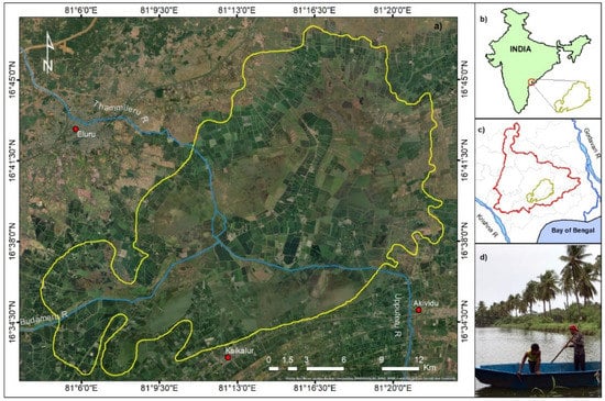
Figure 1.
(a) Kolleru Lake aquaculture; (b) location of the study area in India map; (c) Kolleru Lake catchment; (d) practicing of aquaculture (photo: Monika Mandal).
The increasing encroachment of Kolleru Lake has led to increasing disputes between environmental authorities and the public. The illegal expansion of aquaculture degraded the lake to an extent where no trace of clear water could be recorded over the past three decades []. Despite efforts to restore the lake, irregular lake monitoring activities effectively permitted aquaculture to grow even after restoration measures were implemented. In 2018, fishponds occupied 136 km2 of the lake area, and weed infestations covered about 152 km2, together spanning a total of 58.6% of the lake’s sanctuary, and the rest of the area was occupied by marshy lands, paddy fields, and built-up areas [].
Andhra Pradesh, particularly the massive distribution of inland aquaculture formed around the Kolleru Lake freshwater ecosystem, developed into India’s most important region of inland fishery []. A once-significant lake area was thereby transformed into fishponds, gradually replacing other landcover classes in the wetland ecosystem. To protect the lake from illegal construction, the state government’s initial efforts were made to restore the lake area in 2006 through the “Operation Kolleru” program []. However, a mixture of high population density and the absence of other employment options in the region induced villagers in the Lake Kolleru Basin to aggressively encroach the lake area for aquaculture farming. A single restoration program was not sufficient to effectively stop this process and protect the lake area from illegal fishponds. Therefore, continuous monitoring of fishpond dynamics, particularly the creation of new ponds, is an essential component of future lake restoration measures.
Apart from the aquaculture threats, Lake Kolleru is subjected to multiple external pressure sources from non-point source pollution, particularly agricultural runoff, soil erosion, and sedimentation. In the catchment region, the massive application of chemical fertilizers, including various nitrogen (N) and phosphorus (P) compounds, and their mobilization by agricultural runoff, cause severe water quality problems []. The accumulation of nitrate–nitrogen (NO3_N) deposited near the lake downstream has led to eutrophication and proliferating weeds. Therefore, pollution abatement measures focusing on nutrient loading are necessary for lake water protection.
3. Materials and Methods
3.1. Input Data
In this study, we used the Landsat-8 satellite series composition with 30 m spatial resolution to prepare a land use classification of the Kolleru Lake in 2018. The Landsat data for 2018, comprising 43 images, were aggregated into a single image by applying the median function for the Random Forest (RF) classification model in Google Earth Engine (GEE). To achieve accurate results, the observed fishpond data were extracted by applying the Normalized Difference Water Index (NDWI), which was calculated based on the spectral indices of Landsat-8. Nearly 70 training samples were used to distinguish between six different land use classes: weed infestations, paddy fields, marshy land, the open lake area, built-up land, and fishponds. The polygon featured training samples collected from high-resolution Google Earth images. For each category, approximately more than 10 samples were collected. In 2018, the fishponds occupied a 136 km2 (27.9%) area in the Kolleru wildlife sanctuary. The overall accuracy and Kappa coefficients were 88% and 0.84, respectively. After the “Operation Kolleru” restoration program, a fast-growing distinctive land use class was recognized, which turned into a biodiversity threat to Kolleru Lake’s natural fauna and flora. Kolli et al. (2020), Pattanaik et al. (2010), and Barman (2004), in their previous studies, showed a clear picture of biodiversity loss with extensive land cover changes for economic profits by constructing fishponds [,,]. This study determined the fishpond data, facilitated them to users, and upgraded the latest identification of fishponds across the lake. The fishpond data were extracted from the 2018 land use image in ArcGIS software, the model’s primary data input. The 2018 land use image is mainly used to separate fishponds from other land use classes. Our main objective is to create a web-based application for a better understanding of lake management problems and solutions for any case of secondary restoration measures.
The methodological workflow comprised four stages: problem definition, land use classification and fishpond data extraction, database on a WebGIS, and client–server architecture interface. Figure 2 is an exemplary block diagram representing an inflow of data to the client-side or server-side web server. The first stage includes identifying critical lake factors by communicating with government authorities, stakeholders, research communities, and Kolleru Lake Development Committees (KLDCs). Additional information was obtained from reports in newspapers, magazines, articles, and local news channels. The second stage includes the preparation of a land use map for the year 2018, based on a machine learning algorithm in GEE, and fishpond data extraction to prepare the primary data input for modeling. The third stage is devoted to working with data storage in a database. It also involves data files published on a web server. The final stage implements the web model for protecting the lake ecosystem against the illegal construction of fishponds. Furthermore, the model will be discussed with the researchers, stakeholders, and state government authorities.
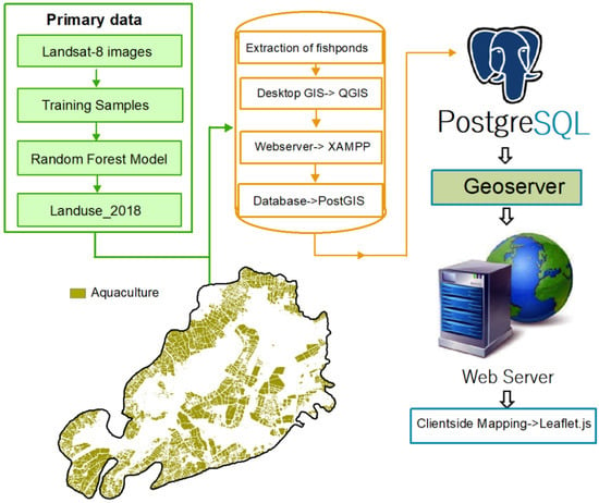
Figure 2.
Methodology flowchart.
The model development was divided into two parts: database preparation and web mapping application. The database consists of fishpond data containing each fishpond’s spatial information (point location) with a column for the X and Y coordinates. The fishpond polygon layer was converted into the geometric location (i.e., medium of each fishpond boundary) to a point shapefile for better mapping. Furthermore, the fishpond data were converted into the GeoJSON (Geographic JavaScript Object Notation) file format. GeoJSON is a required spatial data format for the map library to display the web server’s spatial data []. It is an open standard format designed to represent simple geographical features and their non-spatial attributes, based on JavaScript Object Notation []. GeoJSON is supported by numerous mapping and GIS software packages, including OpenLayers, Leaflet, and MapServer [].
3.2. WebGIS Database
The GIS users require map data maintained by other sources. Therefore, data sharing and updating are crucial. Current advanced technologies such as WebGIS can address GIS data issues, including sharing, processing, manipulation, visualization, and updating in the web server domain to widen the adoption to a larger number of potential users []. GeoServer is an open-source Java-based web mapping service that enables sharing geospatial data and publishes them on the network []. It supports a wide variety of spatial data extensions that handle various datasets, as well. One of the greatest advantages of GeoServer is that it complies with OGC (Open Geospatial Consortium) standards that established a series of data exchange protocols such as Web Map Service (WMS), Web Feature Service (WFS), and Web Coverage Service (WCS) [,,]. There are certain prerequisites to use a GeoServer such as Java, XAMPP, Apache, and Tomcat. This study used the GeoServer database to publish the Kolleru Lake aquaculture data on a web map service to facilitate the public source fishpond data. PostgreSQL extended with PostGIS is an open-source geospatial database with an object-relational database model installed to store all kinds of primary datasets []. In order to maintain data management and data consistency, PostGIS and PostgreSQL, which store both spatial data and attribute data in one database, were used []. The fishpond data were uploaded into the PostgreSQL database through the PostGIS server. Figure 2 shows the PostgreSQL database, which can be used to design the fishpond modeling using the web server architecture system. The fishpond data contain both the spatial data and attribute data information. In the first phase of development, the configuration of fishpond data stored in the PostGIS database was published in the GeoServer. For that, a new workspace named “Kolleru_fishponds” was created, and then a new store comprising all kinds of geospatial data was added. The PostGIS database was facilitated in a new store that previously loaded the fishpond shapefile into the PostgreSQL server. Finally, then the fishpond data could be published on the web GeoServer. The fishponds’ information can be monitored, visualized, or edited by any user from the web server.
3.3. Client–Server Architecture
The web model application has a three-layer architecture. PostgreSQL was extended with PostGIS, used as a backend to store the fishpond data. The GeoServer was used to create layer services and to allow the publication of the PostGIS data in a web server, while the Leaflet library was used to create the Graphical User Interface (GUI). The Leaflet, created by Vladimir Agafonkin, is the leading open-source JavaScript library for web-based interactive maps, and it is updated continuously []. It has been well documented and supported for different applications with large amounts of plugins. For this study, the Leaflet library for a working environment for programming was used. We used it for a web browser user interface to develop a map request entry webpage. For example, if a user has entered the construction of a new illegal fishpond location, the webpage receives a request from the user by selecting a “request map” button. After that, new fishpond data are typically generated in the remote server from the user’s device to synchronize the new data into an existing database.
The client–server module interface affords the individual users to configure and manipulate the fishpond mapping data remotely. The data layer provides access to the database through web services. The web service is a gateway between the data layers to allow the client application and server application to access the database. Furthermore, the published fishpond data layer in GeoServer is accessed through the leaflet. The overall client–server architecture of a generated web mapping application is shown in Figure 3.
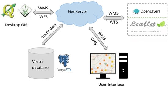
Figure 3.
The client–server architecture of a generated web mapping application.
4. Results
The web-based GIS interface between the server and the client-side module can design both static and dynamic datasets. Thus, the web-based module was developed and integrated with the PostGIS database to store the input data and to model the fishponds. They are required to map ongoing changes and control structures for development activities, designed with XAMPP, machine learning datasets, PostgreSQL database, and GeoServer. At the same time, client-side mapping is facilitated with the Leaflet Java plugin. This module allows users to define the fishpond’s location, which computes input parameter values for the web system. Then, it generates the URL (Uniform Resource Locator) to transfer the input data parameters to the PostGIS database service. It computes all possible dimensions and provides enough storage space for the output data interface. The links to source codes are given in Appendix A.
4.1. Displaying of Fishpond Data on a Webpage
In Figure 4, the displaying of fishpond data on a webpage is shown. Here, the fishpond data stored in a PostGIS database were added to the Leaflet guide through the WMS layer published on a WebGIS platform. The fishpond data are permanently stored in a PostgreSQL database. Figure 4a depicts the fishponds’ locations on a web page shown as a marker cluster layer in the Kolleru Lake ecosystem. A total of 2770 fishponds were identified in the 2018 classified image that was overlayed on a Google Earth image. Since thousands of fishponds were dug into mere fish drains, we could show the data as a cluster marker layer to better visualize the map in close proximity with other marker icons. However, in the case of the maximum zoom in the clustered fishpond area, each fishpond can be separated with a unique marker icon and represented as the area’s center, as shown in Figure 4b. The user can interact with the data of each fishpond location on a web interface. In addition, a layer control panel was provided that allows users to switch between the different base layers for a larger and better visualization of the study area.
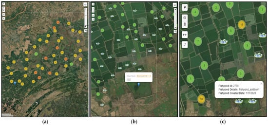
Figure 4.
(a). Fishpond data as shown in the form of a marker cluster layer on a web application in the Kolleru Lake ecosystem. (b) User generates the URL to add the new fishpond location. (c) Result of attribute query based on a user required location.
4.2. Web-Based Server and a Client-Side Module
Figure 4b depicts an exemplary map displayed on a webpage on a web browser user interface. The user sends a request of a fishpond’s location from a client-side computing device to a web server (https://webgis.in/fishponds/index.html, accessed on 7 November 2020). The user’s desired location then shows as a marker with created details “name: Fishpond_addition1”. After entering the specific location of a fishpond to be mapped or added to the database, the user then requests a map by selecting the “Save” button. Before submitting a request to a web server for storing in a database, the user should verify with ground truth information about whether fishponds exist or not. This information is generated on a remote server on the user’s computing device, transmitted to the web server, and eventually displayed on a webpage.
Figure 4c illustrates the user’s desired location of a fishpond saved in a database identified on a webpage with a marker icon (i.e., fishpond ID, latitude and longitude, and date). The newly entered fishpond displayed on a web page shows a new ID, name, and created date. This helps to assess uncertainties related to older and potentially out-of-date information.
Figure 5 shows that new fishpond credentials with the name “Fishponds_addition1” were saved in a PostGIS database and reflected on a map with current time and detail. This application allows any new fishpond entry to be displayed on a webpage and registered in the existing database.
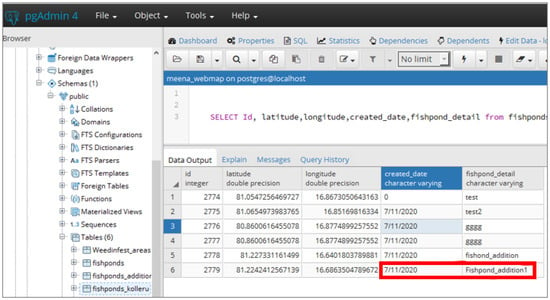
Figure 5.
Storing of new fishpond data in the PostGIS database.
5. Discussion
Figure 6 depicts the displacement of the fishponds’ occupation area before and after the Kolleru wildlife sanctuary restoration measures. The fishpond data for 1999 are derived from the Kolli et al. (2020) land use classification map for further analysis [].
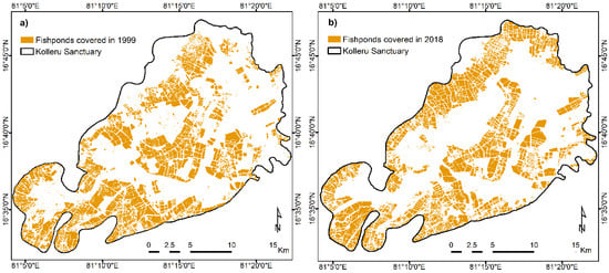
Figure 6.
Fishpond-occupied area in (a) 1999; (b) 2018.
Figure 6a shows that fishponds occupied 29.7% of the overall lake area. This was the highest dominant land use class. The majority of other land use classes of 1999 were paddy fields, marshy lands, and weed-infested areas that had entirely disturbed the lake ecosystem. Floods were aggravated within the fishponds due to the construction of high-rise embankments that polluted the surrounding lake areas []. Restoration processes were initiated to dismantle the fishponds in 2006 through the volunteer “Operation Kolleru” program []. “Operation Kolleru” brought the solution to stop the illegal expansion of fishponds []. The success of this operation was only temporary, as evidenced by the significant development of fishponds across the lake area observed in the 2018 land use image.
Figure 6b illustrates that the 2018 distribution of fishponds in the Kolleru Lake ecosystem resembles—and in some parts, exceeds—the fishpond regions in the 1999 image. The fishpond-occupied area was 27.7%, about 2% less than before the lake restoration processes took place. This indicates that the lake remained stable for a specific period, and the rate of encroachment was relatively faster after restoration. However, during the “Operation Kolleru” program, the affected fishpond areas were turned into marshy lands, accounting for about 59.8% immediately after the restoration program []. Therefore, people targeted these marshy areas for further expansion of fishponds. Additionally, we compared monthly satellite image features and identified that February was well suited for monitoring the fishponds’ development. Since the Kolleru Lake ecosystem marshy areas dug into fishponds, especially in February, the lake is dried and easy for digging. Therefore, February is a suitable time to monitor the illegal construction of fishponds. Our model will be useful for both monitoring and decision-making solutions for stakeholders.
Figure 7 illustrates the loss and gain of fishponds between governmental and human activities across the Kolleru Lake ecosystem. The lake endured intensive stress due to frequent land use changes before and after restoration practices. At the time of restoration in 2006, a significant number of fishponds were destroyed.
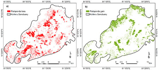
Figure 7.
(a) Fishpond loss after 1999; (b) fishponds gained in 2018.
Figure 7a depicts the fishpond loss area after the restoration program, which is about 5.17% of the lake area. Most destroyed fishponds were concentrated in the middle lake area, especially within the 3 ft contour level. Thus, the local people used the 5 ft contour area for aquaculture farming and were not interested in returning the land to the government. Furthermore, they encroached the 3 ft lake area, completely degrading the lake ecosystem. The state government of Andhra Pradesh intended to protect the lake area up to the 3 ft contour (Figure 7a), which resulted in the “Operation Kolleru” program.
According to Figure 7b, the fishponds’ growth showed in the direction of the 5 ft contour area (i.e., around the 3 ft contour level) of the 2018 image. The fishponds gained after the restoration program account for 4.82% of the lake area. We compared the loss and gain of fishponds between 1999 and 2018, or before and after the restoration program, for a better interpretation analysis. Due to the “Operation Kolleru” program, the lake’s 3 ft area was not encroached by the local people for aquaculture practice (Figure 7b). However, it was mostly covered with weeds, marshy areas, and less area with paddy fields. Better lake measurement practices are essential for lake protection.
Human economic growth activities degrade the lakes, and Kolleru Lake is the best example of India’s largest freshwater aquaculture expansion. The state government has formulated committees for Kolleru development activities. However, lake encroachment by illegal activities has dominated the lake ecosystem.
6. Conclusions, Limitations, and Future Work
Here, we described the development of an interactive web mapping application for monitoring aquaculture dynamics in Kolleru Lake. In addition to the values of stakeholders and decision makers, this methodological tool plays a crucial role in surveying land use dynamics in the lake basin. Recently, the lake has experienced land degradation due to the expansion of fishponds across the lake region. According to the results and analysis in this study, environmental managers and authorities can strongly benefit from a tool that combines a remote sensing approach with crowd-sourced field mapping.
A machine learning-based algorithm was used to prepare the land use categorized map in Google Earth Engine. In the context of the present work, the prototype version of the web-based services system constituted an exemplary but pragmatic approach for monitoring lake degradation by aquaculture. This was achieved through a GIS interface to the web-based system to model the fishponds. This model is fully automated through the SQL programming, the PostGIS database, the server, and the client-side web interface. The model helps the government, based on the lake’s present land use conditions, where the user can update the illegal construction of fishpond location details to the web server. Thus, decision makers can employ this easy-to-use system for identifying the most affected areas by aquaculture growth and establish better lake management activities. This application demonstrates how the web–client interaction can be easily used for minimizing the expansion of illegal fishponds in the Kolleru Lake ecosystem.
It is important to acknowledge the current limitations of this study. For instance, the fishpond data have not been cross-checked with the ground truth data but only validated with high-resolution Google Earth images. Therefore, further investigations should include detailed ground-based data collections. A second potential issue is data redundancy, as any registration of new fishpond data by a user results in the generation of new ID and latitude/longitude coordinates in the database. As individual ponds may be counted several times, the number of fishponds in the Kolleru Lake wetland may be overestimated. In such instances, the use of automated and manual consistency checks and an advancement of the variables considered for fishpond registration must be considered in the future. Finally, in this study, we developed a web-based decision support system using open-source technologies. This web-based approach obviously requires an internet connection, which is not always available to stakeholders living in rural areas, e.g., due to their socio-economic status or limited telecommunication networks. Therefore, the integration of offline mobile applications can be considered in the future.
Author Contributions
Conceptualization, D.K. and C.O.; methodology, M.K.K.; software, M.K.K.; validation, M.K.K. and N.M.K.; formal analysis, C.O.; investigation, M.K.K. and N.M.K.; resources, D.K.; data curation, M.K.K.; writing—original draft preparation, M.K.K. and N.M.K.; writing—review and editing, D.K., C.O. and N.M.K.; visualization, M.K.K.; supervision, C.O. and D.K.; project administration, M.K.K. and N.M.K.; funding acquisition, N.M.K. All authors have read and agreed to the published version of the manuscript.
Funding
This research received no external funding.
Institutional Review Board Statement
Not applicable.
Informed Consent Statement
Not applicable.
Data Availability Statement
The data used in this study can be made available upon request to the corresponding author.
Acknowledgments
The authors would like to thank Rahul Gupta for assisting in developing the model and Monika Mandal for providing field photos and valuable information.
Conflicts of Interest
The authors declare no conflict of interest.
Appendix A
Source code for the developed web-based model for the sustainable management of aquaculture in the Kolleru Lake is available at: https://github.com/aneemkolli/Kolleru_fishponds.git. The weblink for the Kolleru Lake fishponds is available at https://webgis.in/fishponds/index.html.
References
- Fluet-Chouinard, E.; Messager, M.; Lehner, B.; Finlayson, C. Freshwater Lakes and Reservoirs. In The Wetland Book. Dordrecht; Finlayson, C., Milton, G., Prentice, R., Davidson, N., Eds.; Springer: Berlin/Heidelberg, Germany, 2018. [Google Scholar]
- Sterner, R.W.; Keeler, B.; Polasky, S.; Poudel, R.; Rhude, K.; Rogers, M. Ecosystem services of Earth’s largest freshwater lakes. Ecosyst. Serv. 2020, 41, 101046. [Google Scholar] [CrossRef]
- Mammides, C. A global assessment of the human pressure on the world’s lakes. Glob. Environ. Chang. 2020, 63, 102084. [Google Scholar] [CrossRef]
- Ding, L.; Chen, K.-L.; Cheng, S.-G.; Wang, X. Water ecological carrying capacity of urban lakes in the context of rapid urbanization: A case study of East Lake in Wuhan. Phys. Chem. Earth Parts A/B/C 2015, 89-90, 104–113. [Google Scholar] [CrossRef]
- Wang, Y.; Peng, B.; Xion, J.; Zhang, H. Study on the spatial pattern and influencing factors of population urbanization of Dongting Lake area. Grograph. Res. 2013, 32, 1912–1922. [Google Scholar]
- Zeballos-Velarde, C.; Yamaguchi, K. Impacts of land reclamation on the landscape of Lake Biwa, Japan. Procedia-Soc. Behav. Sci. 2011, 19, 683–692. [Google Scholar] [CrossRef][Green Version]
- Lienhoop, N.; Messner, F. The Economic Value of Allocating Water to Post-Mining Lakes in East Germany. Water Resour. Manag. 2009, 23, 965–980. [Google Scholar] [CrossRef]
- Jayanthi, M.; Rekha, P.N.; Kavitha, N.; Ravichandran, P. Assessment of impact of aquaculture on Kolleru Lake (India) using remote sensing and Geographical Information System. Aquac. Res. 2006, 37, 1617–1626. [Google Scholar] [CrossRef]
- Hickley, P.; Muchiri, M.; Boar, R.; Britton, R.; Adams, C.; Gichuru, N.; Harper, D. Habitat degradation and subsequent fishery collapse in Lakes Naivasha and Baringo, Kenya. Ecohydrol. Hydrobiol. 2004, 4, 503–517. [Google Scholar]
- Schindler, D.W.; Carpenter, S.; Chapra, S.C.; Hecky, R.E.; Orihel, D. Reducing Phosphorus to Curb Lake Eutrophication is a Success. Environ. Sci. Technol. 2016, 50, 8923–8929. [Google Scholar] [CrossRef]
- Ekholm, P.; Mitikka, S. Agricultural Lakes in Finland: Current Water Quality and Trends. Environ. Monit. Assess. 2006, 116, 111–135. [Google Scholar] [CrossRef]
- Cooper, S.D.; Lake, P.S.; Sabater, S.; Melack, J.M.; Sabo, J.L. The effects of land use changes on streams and rivers in mediterranean climates. Hydrobiologia 2013, 719, 383–425. [Google Scholar] [CrossRef]
- Mao, D.; Cherkauer, K.A. Impacts of land-use change on hydrologic responses in the Great Lakes region. J. Hydrol. 2009, 374, 71–82. [Google Scholar] [CrossRef]
- Pham, S.V.; Leavitt, P.R.; McGowan, S.; Peres-Neto, P. Spatial variability of climate and land-use effects on lakes of the northern Great Plains. Limnol. Oceanogr. 2008, 53, 728–742. [Google Scholar] [CrossRef]
- Hecky, R.E.; Bootsma, H.A.; Kingdon, M.L. Impact of Land Use on Sediment and Nutrient Yields to Lake Malawi/Nyasa (Africa). J. Great Lakes Res. 2003, 29, 139–158. [Google Scholar] [CrossRef]
- Bleischwitz, R.; Spataru, C.; Vandeveer, S.D.; Obersteiner, M.; Van Der Voet, E.; Johnson, C.; Andrews-Speed, P.; Boersma, T.; Hoff, H.; Van Vuuren, D.P. Resource nexus perspectives towards the United Nations Sustainable Development Goals. Nat. Sustain. 2018, 1, 737–743. [Google Scholar] [CrossRef]
- Lal, R. The Nexus Approach to Managing Water, Soil, and Waste under Changing Climate and Growing Demands on Natural Resources. In Governing the Nexus: Water, Soil, and Waste Resources Considering Global Change; Kurian, M., Ardakanian, R., Eds.; Springer: Berlin/Heidelberg, Germany, 2015; pp. 39–60. [Google Scholar]
- Jain, S.K.; Lohani, A.K.; Singh, R.D.; Chaudhary, A.; Thakural, L.N. Glacial lakes and glacial lake outburst flood in a Himalayan basin using remote sensing and GIS. Nat. Hazards 2012, 62, 887–899. [Google Scholar] [CrossRef]
- Mergili, M.; Schneider, J.F. Regional-scale analysis of lake outburst hazards in the southwestern Pamir, Tajikistan, based on remote sensing and GIS. Nat. Hazards Earth Syst. Sci. 2011, 11, 1447–1462. [Google Scholar] [CrossRef]
- Leblanc, M.; Favreau, G.; Tweed, S.; Leduc, C.; Razack, M.; Mofor, L. Remote sensing for groundwater modelling in large semiarid areas: Lake Chad Basin, Africa. Appl. Hydrogeol. 2006, 15, 97–100. [Google Scholar] [CrossRef]
- Ye, Q.; Zhu, L.; Zheng, H.; Naruse, R.; Zhang, X.; Kang, S. Glacier and lake variations in the Yamzhog Yumco basin, southern Tibetan Plateau, from 1980 to 2000 using remote-sensing and GIS technologies. J. Glaciol. 2007, 53, 673–676. [Google Scholar] [CrossRef]
- Zainab, N.; Tariq, A.; Siddiqui, S. Development of Web-Based GIS Alert System for Informing Environmental Risk of Dengue Infections in Major Cities of Pakistan. Geosfera Indones. 2021, 6, 77–95. [Google Scholar] [CrossRef]
- D’Amico, G.; Szopik-Depczyńska, K.; Beltramo, R.; D’Adamo, I.; Ioppolo, G. Smart and Sustainable Bioeconomy Platform: A New Approach towards Sustainability. Sustainability 2022, 14, 466. [Google Scholar] [CrossRef]
- Li, C.; Longley, P. A Test Environment for Location-Based Services Applications. Trans. GIS 2006, 10, 43–61. [Google Scholar] [CrossRef]
- Constanza, R.; Kubiszewski, I. A Nexus Approach to Urban and Regional Planning Using the Four-Capital Frame-work of Ecological Economics. In Environmental Resource Management and the Nexus Approach; Hettiarachchi, H., Ardakanian, R., Eds.; Springer: Cham, Switzerland, 2016; pp. 79–111. [Google Scholar]
- Kurian, M.; Ardakanian, R. The Nexus Approach to Governance of Environmental Resources Considering Global Change. In Governing the Nexus: Water, Soil and Waste Resources Considering Global Change; Kurian, M., Ardakanian, R., Eds.; Springer: Dordrecht, The Netherlands, 2014; pp. 3–13. [Google Scholar] [CrossRef]
- Kolli, M.K.; Opp, C.; Karthe, D.; Groll, M. Mapping of Major Land-Use Changes in the Kolleru Lake Freshwater Ecosystem by Using Landsat Satellite Images in Google Earth Engine. Water 2020, 12, 2493. [Google Scholar] [CrossRef]
- Kolli, M.K.; Opp, C.; Groll, M. Identification of Critical Diffuse Pollution Sources in an Ungauged Catchment by Using the Swat Model- A Case Study of Kolleru Lake, East Coast of India. Asian J. Geogr. Res. 2020, 3, 53–68. [Google Scholar] [CrossRef]
- Azeez, P.; Kumar, A.; Choudhury, B.; Sastry, V.; Upadhyay, S.; Reddy, K.; Rao, K. Report on the Proposal for Downsizing the Kolleru Wildlife Sanctuary (+5 to +3 Feet Contour); The Ministry of Environment and Forests Government of India: New Delhi, India, 2011.
- Rao, K.; Krishna, G.; Malini, B. Kolleru lake is vanishing—A revelation through digital image processing of IRS-1D LISS III sensor data. Curr. Sci. 2004, 86, 1312–1316. [Google Scholar]
- Harikrishna, K. Land Use/Land Cover patterns in and around Kolleru Lake, Andhra Pradesh, India Using Remote Sensing and GIS Techniques. Int. J. Remote Sens. Geosci. 2013, 2, 2319–3484. [Google Scholar]
- Belton, B.; Padiyar, A.; Ravibabu, G.; Rao, K.G. Boom and bust in Andhra Pradesh: Development and transformation in India’s domestic aquaculture value chain. Aquaculture 2017, 470, 196–206. [Google Scholar] [CrossRef]
- Pattanaik, C.; Prasad, S.; Nagabhatla, N.; Sellamuthu, S. A case study of Kolleru Wetland (Ramsar site), India using remote sensing and GIS. IUP J. Earth Sci. 2010, 4, 70–77. [Google Scholar]
- Barman, R.P. The fishes of the Kolleru Lake, Andhra Pradesh, India, with comments. Rec. Zool. Sur. India 2004, 103, 83–89. [Google Scholar]
- Butler, H.; Daly, M.; Doyle, A.; Gillies, S.; Hagen, S.; Schaub, T. The Geojson Format; Technical Report; Internet Engineering Task Force (IETF): Fremon, CA, USA, 2016. [Google Scholar]
- Piedrafita, R.; Béjar, R.; Blasco, R.; Marco, A.; Zarazaga-Soria, F.J. The digital ‘connected’ earth: Open technology for providing location-based services on degraded communication environments. Int. J. Digit. Earth 2017, 11, 761–782. [Google Scholar] [CrossRef]
- Horbiński, T.; Lorek, D. The use of Leaflet and GeoJSON files for creating the interactive web map of the preindustrial state of the natural environment. J. Spat. Sci. 2020, 1–17. [Google Scholar] [CrossRef]
- Masetti, G.; Kelley, J.G.W.; Johnson, P.; Beaudoin, J. A Ray-Tracing Uncertainty Estimation Tool for Ocean Mapping. IEEE Access 2017, 6, 2136–2144. [Google Scholar] [CrossRef]
- Dai, Y.; Duan, Z.; Ai, D. Construction and Application of Field Investigation Support Platform for Land Spatial Planning Based on GeoServer. J. Phys. Conf. Ser. 2020, 1621. [Google Scholar] [CrossRef]
- Gao, S.; Mioc, D.; Anton, F.; Yi, X.; Coleman, D.J. Online GIS services for mapping and sharing disease information. Int. J. Heal. Geogr. 2008, 7, 8. [Google Scholar] [CrossRef] [PubMed]
- Yu, X.W.; Liu, H.Y.; Yang, Y.C.; Zhang, X.; Li, Y.W. GeoServer Based Forestry Spatial Data Sharing and Integration. Appl. Mech. Mater. 2013, 295–298, 2394–2398. [Google Scholar] [CrossRef]
- Boulos, M.N.K.; Honda, K. Web GIS in practice IV: Publishing your health maps and connecting to remote WMS sources using the Open Source UMN MapServer and DM Solutions MapLab. Int. J. Heal. Geogr. 2006, 5, 6. [Google Scholar] [CrossRef] [PubMed]
- Bordogna, G.; Kliment, T.; Frigerio, L.; Brivio, P.A.; Crema, A.; Stroppiana, D.; Boschetti, M.; Sterlacchini, S. A Spatial Data Infrastructure Integrating Multisource Heterogeneous Geospatial Data and Time Series: A Study Case in Agriculture. ISPRS Int. J. Geo-Inf. 2016, 5, 73. [Google Scholar] [CrossRef]
- Zhang, L.; Yi, J. Management methods of spatial data based on PostGIS. In Proceedings of the 2010 Second Pacific-Asia Conference on Circuits, Communications and System, Beijing, China, 1–2 August 2010; Volume 1, pp. 410–413. [Google Scholar]
- Peterson, G. GIS cartography. In A Guide to Effective Map Design, 2nd ed.; CRC Press: Boca Raton, FL, USA, 2014. [Google Scholar]
Publisher’s Note: MDPI stays neutral with regard to jurisdictional claims in published maps and institutional affiliations. |
© 2022 by the authors. Licensee MDPI, Basel, Switzerland. This article is an open access article distributed under the terms and conditions of the Creative Commons Attribution (CC BY) license (https://creativecommons.org/licenses/by/4.0/).