Feature Papers of Drones Volume II

A topical collection in Drones (ISSN 2504-446X).

Viewed by 4896

Editors


E-Mail Website
Collection Editor
Cartographic and Land Engineering Department, Higher Polytechnic School of Avila, University of Salamanca, Hornos Caleros, 50 05003 Avila, Spain
Interests: photogrammetry; laser scanning; 3D modeling; topography; cartography
Special Issues, Collections and Topics in MDPI journals

E-Mail Website
Collection Editor
Department of Mining Technology, Topography and Structures, University of León, Avda. Astorga, s/n, 24401 Ponferrada, Spain
Interests: photogrammetry; drones; laser scanning; radiometric calibration; remote sensing; RGB-D sensors; 3D modeling; mobile mapping; metrology; verification; inspection; quality control
Special Issues, Collections and Topics in MDPI journals

Topical Collection Information

Dear Colleagues,

As editors of Drones, we are pleased to announce a topical collection entitled “Feature papers of Drones—Volume II”. This topical collection will be a compilation of articles, communications, and review articles from top researchers describing novel or new cutting-edge designs, developments, and/or applications of unmanned vehicles (aerial, terrestrial, or water/underwater). We welcome the submission of manuscripts from Editorial Board Members and outstanding scholars invited by the Editorial Board and the Editorial Office.

Prof. Dr. Diego González-Aguilera
Prof. Dr. Pablo Rodríguez-Gonzálvez
Collection Editors

Manuscript Submission Information

Manuscripts should be submitted online at www.mdpi.com by registering and logging in to this website. Once you are registered, click here to go to the submission form. Manuscripts can be submitted until the deadline. All submissions that pass pre-check are peer-reviewed. Accepted papers will be published continuously in the journal (as soon as accepted) and will be listed together on the collection website. Research articles, review articles as well as short communications are invited. For planned papers, a title and short abstract (about 100 words) can be sent to the Editorial Office for announcement on this website.

Submitted manuscripts should not have been published previously, nor be under consideration for publication elsewhere (except conference proceedings papers). All manuscripts are thoroughly refereed through a single-blind peer-review process. A guide for authors and other relevant information for submission of manuscripts is available on the Instructions for Authors page. Drones is an international peer-reviewed open access monthly journal published by MDPI.

Please visit the Instructions for Authors page before submitting a manuscript. The Article Processing Charge (APC) for publication in this open access journal is 2600 CHF (Swiss Francs). Submitted papers should be well formatted and use good English. Authors may use MDPI's English editing service prior to publication or during author revisions.

Published Papers (2 papers)

2024

16 pages, 6176 KiB  
Article
Influence of the Inclusion of Off-Nadir Images on UAV-Photogrammetry Projects from Nadir Images and AGL (Above Ground Level) or AMSL (Above Mean Sea Level) Flights
by Francisco Agüera-Vega, Ezequiel Ferrer-González, Patricio Martínez-Carricondo, Julián Sánchez-Hermosilla and Fernando Carvajal-Ramírez
Drones 2024, 8(11), 662; https://doi.org/10.3390/drones8110662 - 10 Nov 2024
Viewed by 708
Abstract
UAV-SfM techniques are in constant development to address the challenges of accurate and precise mapping in terrains with complex morphologies. In contrast with the traditional photogrammetric processes, where only nadir images were considered, the combination of those with oblique imagery, also called off-nadir, [...] Read more.
UAV-SfM techniques are in constant development to address the challenges of accurate and precise mapping in terrains with complex morphologies. In contrast with the traditional photogrammetric processes, where only nadir images were considered, the combination of those with oblique imagery, also called off-nadir, has emerged as an optimal solution to achieve higher accuracy in these kinds of landscapes. UAV flights at a constant height above ground level (AGL) have also been considered a possible alternative to improve the resulting 3D point clouds compared to those obtained from constant height above mean sea level (AMSL) flights. The aim of this study is to evaluate the effect of incorporating oblique images as well as the type of flight on the accuracy and precision of the point clouds generated through UAV-SfM workflows for terrains with complex geometries. For that purpose, 58 scenarios with different camera angles and flight patterns for the oblique images were considered, 29 for each type of flight (AMSL and AGL). The 3D point cloud derived from each of the 58 scenarios was compared with a reference 3D point cloud acquired with a terrestrial laser scanner (TLS). The results obtained confirmed that both incorporating oblique images and using AGL flight mode have a positive effect on the mapping. Combination of nadir image blocks, obtained from an AGL crosshatch flight plan, with supplemental oblique images collected with a camera angle of between 20° and 35° yielded the best accuracy and precision records. Full article
Show Figures

Figure 1

25 pages, 3769 KiB  
Article
Harmonized Skies: A Survey on Drone Acceptance across Europe
by Maria Stolz, Anne Papenfuß, Franziska Dunkel and Eva Linhuber
Drones 2024, 8(3), 107; https://doi.org/10.3390/drones8030107 - 20 Mar 2024
Cited by 2 | Viewed by 2776
Abstract
This study investigated the public acceptance of drones in six European countries. For this purpose, an online questionnaire was created, which was completed by 2998 participants. The general attitude towards drones, concerns, approval for different use cases, minimum tolerable flight altitude, acceptable flight [...] Read more.
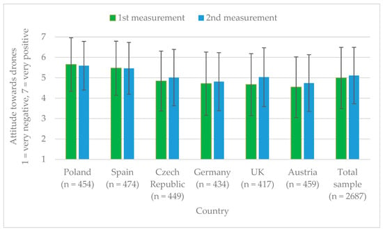
This study investigated the public acceptance of drones in six European countries. For this purpose, an online questionnaire was created, which was completed by 2998 participants. The general attitude towards drones, concerns, approval for different use cases, minimum tolerable flight altitude, acceptable flight areas, and the impact of personal and demographic attributes on drone acceptance were analyzed. Overall, attitudes towards drones were quite positive in the entire sample and even improved slightly in a second measurement at the end of the questionnaire. However, the results also show that acceptance strongly depends on the use case. Drones for civil and public applications are more widely accepted than those for private and commercial applications. Moreover, the population still has high concerns about privacy and safety. Knowledge about drones, interest in technologies, and age proved essential to predicting acceptance. Thus, tailored communication strategies, for example, through social media, can enhance public awareness and acceptance. Full article
Show Figures

Figure 1

Back to TopTop