Abstract
Drought is a complex natural disaster with significant implications for agriculture, water resources, and socioeconomic development. Accurate and timely assessment of meteorological drought is crucial for effective management and mitigation strategies. Climate change has led to a rise in climatic anomalies, such as droughts, floods, heatwaves, and cold snaps, which have severe impacts on human well-being and societal patterns. Droughts, which are prolonged periods of limited or absent rainfall, pose significant challenges for sectors like agriculture, energy, and enterprises, especially in economically reliant countries with inadequate water management infrastructure. Drought indicators are essential in meteorology, agriculture, and hydrology for monitoring drought conditions. Accurate drought assessment relies on quantitative index-based comprehensive drought indices, such as India’s Aridity Anomaly Index (AAI), Deciles Index, Percent of Normal Index, Reconnaissance Drought Index (RDI), and the Palmer Drought Severity Index (PDSI). Drought management involves analyzing risk components and using analytical tools for decision making. A decision support system includes institutional, methodological, public, and operational components. Long-term actions include demand reduction through economic incentives, while short-term actions include increasing water supply through wastewater reutilization, inter-basin water conveyance, reservoir construction, and agricultural ponds. Impact minimization is achieved through educational initiatives, reallocating water resources, early warning systems, and insurance programs. Challenges include developing technologies to integrate data sources and create unified indicators, and geospatial decision-support systems facilitate hazard mapping and strategic drought management plans.
1. Introduction
Climate change has significantly altered ecosystems, leading to anomalous climates such as more frequent droughts, floods, heatwaves, and cold snaps. This has resulted in increased harm to human life and habits, causing a significant shift in climatic cycles [1].
Drought is a disruption of the rainfall regime, characterized by no precipitation or below average rainfall lasting long enough to create hydrological and agricultural hazards. Drought, characterized by prolonged low precipitation, significantly impacts various ecosystems by causing water scarcity, influenced by factors like water demand, hydrological processes, and weather conditions.
A protracted period of below-average precipitation causes water deficits in the atmosphere and is the hallmark of a “meteorological drought”. When there is not enough soil moisture to meet the needs of crops, an “agricultural drought” occurs, which lowers agricultural productivity. A “hydrological drought” affects the amount of water in rivers and aquifers by reducing streamflow, groundwater levels, or reservoir storage. The term “socioeconomic drought” refers to how water scarcity affects human endeavors including industry, urbanization, and water delivery. The term “ecological drought” describes how a lack of water affects ecosystem services, biodiversity, and habitats [2,3].
Monitoring the drought is essential for determining the availability of water and efficiently managing water resources [4]. Farmers can better prepare for future water shortages and modify their agricultural operations by keeping an eye on drought conditions [5]. For the purpose of forecasting crop yields and guaranteeing food security in areas where water is scarce, drought monitoring is crucial [6]. Droughts can have detrimental effects on the economy; monitoring enables the evaluation of these effects and the creation of mitigation plans [7]. Early warning system development is aided by timely detection of drought conditions through monitoring, allowing for proactive measures [8]. Monitoring droughts helps to better understand how ecosystems are impacted by water scarcity, which supports conservation efforts [9]. Monitoring droughts helps with adaptation methods by shedding light on the trends and patterns of droughts in relation to climate change [10]. The interplay of various environmental factors, including rainfall, temperature, humidity, wind, cloud cover, and drought, is crucial for predicting and managing the impacts of drought. Low rainfall can lead to drought, causing increased temperatures and decreased humidity. These changes also affect plants, water resources, and human societies, causing stress, reduced crop yields, and water levels in rivers and reservoirs as described in Figure 1.
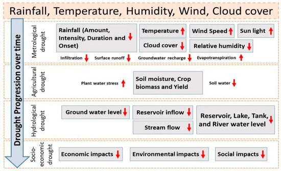
Figure 1.
Schematic representation of drought process (Zargar et al. 2011) [11].
A review that highlights several drought indices is beneficial for hydrology, climatology, and water resource management in a number of ways. This kind of review advances the scientific knowledge of drought assessment techniques, assists practitioners and researchers in selecting suitable indices for particular applications, and supports the creation of efficient plans for drought management and monitoring.
The comparative study of drought indices assesses the merits and demerits of several drought indices in evaluating droughts from meteorological, agricultural, and hydrological perspectives [12]. Application at all scales and areas: The aim of this study is to evaluate the effectiveness and suitability of drought indices across a range of geographical locations and at different temporal and spatial scales [13]. Technological developments in drought monitoring are used to investigate how new developments in remote sensing and satellite-based technology for drought monitoring interact with conventional drought indices [14]. The goal of this study is to examine how drought affects water resources, such as groundwater, reservoirs, and river flow, and to talk about how the selection of a drought index affects management choices [15]. The goal is to investigate the relationships between drought trends and climate change, as well as the ways in which various indicators reflect shifting trends and levels of drought intensity [16].
To effectively create ways to alleviate the effects of drought on water resources, agriculture, ecosystems, and communities, it is imperative to investigate drought management measures, so as to investigate methods for maximizing water usage in urban areas, industries, and agriculture in order to reduce water loss and raise total water use efficiency [17]. To investigate the creation and uptake of crop types that can withstand drought and are more resistant to water scarcity [18], the aim of this study is to explore comprehensive strategies that take into account the whole water cycle and involve many sectors in order to improve drought resistance and water availability [19]. We aim to investigate how early warning systems and cutting-edge monitoring technology can be used to detect drought conditions early and take proactive measures to combat them [20]; to investigate methods for collecting and storing rainfall in order to augment water supplies during dry spells, particularly in regions with erratic precipitation [21]; and to investigate how local knowledge and community involvement may be utilized to create and execute grassroots drought adaptation plans [22].
2. Materials and Methods
Drought Indices Overview and Comparison
The tables present a list of drought indicators used in meteorology, agriculture, and hydrology to assess and monitor drought conditions. These indices use various input parameters and methodologies to measure drought severity. Preparatory research is needed to identify the right indicators for the period, location, and climate. These indices help sectors prepare for and mitigate drought impacts, ensuring the safety and sustainability of agricultural and other sectors. They are essential for monitoring drought conditions and ensuring a country’s preparedness for potential drought impacts. Accurate drought assessment and decision-making rely on quantitative index-based comprehensive drought indices are given by Table 1 and Table 2.

Table 1.
Comprehensive drought indices-based on meteorology.
Table 2.
Comprehensive drought indices-based on soil moisture.
The Aridity Anomaly Index (AAI) is a drought indicator for India, while the Deciles Index assesses precipitation frequency and distribution. The Percent of Normal Index (PNI) monitors drought-related impacts across geographical locations. The Standardized Precipitation Index (SPI) calculates precipitation likelihood using historical records. Other indicators include the Reconnaissance Drought Index (RDI), Palmer Drought Severity Index (PDSI), and Standardized Precipitation Evapotranspiration Index (SPEI) as described in Table 1.
Soil Moisture Anomaly (SMA) is a statistical tool used to detect anomalies in soil moisture levels over time, assessing soil conditions and tracking drought effects on agriculture and crop production. The Soil Moisture Deficit Index (SMDI) measures moisture loss by comparing actual soil moisture level and field capacity. SMI evaluates soil moisturizing conditions by comparing current soil moisture content with maximum and minimum values over a given period. The Normalized Soil Moisture Index (NSMI) standardizes soil moisture content, making it easier to compare results from different locations. SSMA assesses irregularities in the soil’s top layer and offers information about transient changes in moisture content. These tools are useful for various applications, including drought monitoring, agricultural planning, water resource management, environmental studies, hydrological modeling, and climate change studies.
3. Drought Management
Risk management for droughts involves understanding drought risk components and analyzing alternative strategies. This involves using analytical tools for decision making and developing strategies to manage uncertainty and risk perception. This work aims to present a planning process for preparing a decision support system for drought risk management [36].
- Institutional component—The institutional framework should include water, meteorology, agriculture, environment, and socioeconomic institutions to develop integrated drought risk management systems.
- Methodological component—This is the framework for drought risk assessment and vulnerability assessment, outlining procedures for assessing drought risks, analyzing climate trends and vulnerability factors, and mapping drought-prone areas for identification of risk elements and implementing mitigation measures.
- Public component—The framework for drought prevention and response outlines strategies for prompt responses, short-term readiness, and long-term resilience, requiring local institutions to develop and execute programs aimed at mitigating drought, similar to strategic planning.
- The operational component offers guidance for developing a decision support system for drought risk management, focusing on monitoring current conditions, predicting future droughts, and proactively implementing drought prevention.
Drought management involves both long-term and short-term strategies. Long-term measures involve reducing demand through economic incentives and promoting water conservation through drought-resistant alternatives. Short-term measures include increasing water supply through wastewater reutilization, reservoir construction, and agricultural ponds. Educational initiatives improve preparedness, reallocate resources, establish early warning systems, and execute insurance programs. Temporary measures mitigate revenue losses and tax burdens as shown in Table 3.
Table 3.
Long and short-term drought management [37].
The inclusion of drought evaluation, tracking, future risk estimation, mitigation strategies, and risk management with drought records management within the decision support system is vital. This should be conducted while considering hydro-meteorological observational data and drought assessments. The diagram illustrates a drought risk management framework consisting of four components: institutional, operational, methodological, and public. The institutional component includes government agencies and NGOs, while the operational component involves water conservation and preparedness plans. The methodological component uses drought indices and climate models to assess and monitor drought risk as shown in Figure 2.
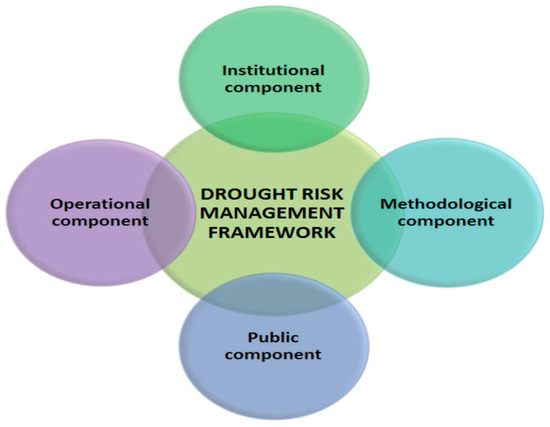
Figure 2.
Framework for drought risk management [38].
Drought indicators utilize established monitoring networks to furnish practical information regarding drought danger. One of the challenges that researchers face is the development of technologies that can effectively integrate various sources of data and generate a unified drought indicator. Real-time apps facilitate the dissemination of readily available meteorological and hydrological data [39].
- Application scope. Drought indicators utilize established monitoring networks to furnish practical information regarding drought danger. One of the challenges that researchers face is the development of technologies that can effectively integrate various sources of data and generate a unified drought indicator. Real-time apps facilitate the dissemination of readily available meteorological and hydrological data.
- Temporal scale. The assessment of drought hazards across different sectors necessitates varying temporal resolutions. However, drought indices have the capability to capture notable meteorological and hydrological fluctuations throughout a range of time periods.
- Spatial scale. The effective management of drought risk necessitates a concentrated approach at both regional and local levels, owing to the inherent unpredictability of hydrometeorological conditions. The utilization of standardized methodologies for assessing drought hazards facilitates the generation of maps that can be applied across various locations.
- Frequency analysis. The examination of time series data on drought indices can offer valuable insights on the susceptibility of a basin to the development, progression, and endurance of droughts, hence facilitating the prediction of droughts in real-time.
The primary objective is to create geospatial decision-support systems for the purpose of managing drought risk. This will be achieved through the utilization of remote sensing data as well as geoinformatics approaches. These tools facilitate the process of hazard mapping, the development of strategic drought management plans, and the efficient flow of information, especially in the context of climate change scenarios.
4. Conclusions and Future Directions
Climate change has increased climatic anomalies like droughts, floods, heatwaves, and cold snaps, affecting human well-being and social patterns. Droughts pose challenges for sectors like agriculture, energy, and enterprises, especially in economically reliant countries with inadequate water management infrastructure. Drought indicators are essential for meteorology, agriculture, and hydrology monitoring, using quantitative index-based comprehensive indices like India’s Aridity Anomaly Index.
Drought management involves analyzing risk components and using analytical tools for decision making. A decision support system includes institutional, methodological, public, and operational components. Long-term actions include demand reduction through economic incentives, while short-term actions include increasing water supply through wastewater reutilization, inter-basin conveyance, reservoir construction, and agricultural ponds.
Climate change is altering precipitation distribution, necessitating the use of drought indices. Future research should integrate remote sensing technology, satellite data, and ground-based monitoring systems. Machine learning and artificial intelligence can improve drought prediction and risk assessment. Prioritizing agricultural practices, water resource management, and infrastructure upgrades is crucial for climate change adaptation.
Author Contributions
Conceptualization, M.S.; Introduction, H.M. and R.M.S.; Materials and Methods, F.R. and A.R.; Drought Management, U.Z. and R.M.S.; Future Directions and Conclusions, M.Z. and M.A.S.; writing—original draft preparation, M.S.; writing—review and editing, M.S. All authors have read and agreed to the published version of the manuscript.
Funding
This research received no external funding.
Institutional Review Board Statement
Not applicable.
Informed Consent Statement
Not applicable.
Data Availability Statement
Free sources of satellite data are available for the study, but for better accuracy unavailability of data due to non-free availability.
Conflicts of Interest
The authors declare no conflicts of interest.
References
- IPCC. Managing the risks of extreme events and disasters to advance climate change adaptation. In A Special Report of Working Groups, I and II of the Intergovernmental Panel on Climate Change; Field, C.B., Stocker, T., Qin, D., Barros, V., Eds.; Cambridge University Press: Cambridge, UK, 2012. [Google Scholar] [CrossRef]
- Gimeno-Sotelo, L.; Kenawy, A.E.; Franquesa, M.; Noguera, I.; Fernández-Duque, B.; Domínguez-Castro, F.; Peña-Angulo, D.; Reig, F.; Sorí, R.; Gimeno, L.; et al. Assessment of the global coherence of different types of droughts in model simulations under a high anthropogenic emission scenario. ESS Open Arch. 2023. [Google Scholar] [CrossRef]
- Stagge, J.H.; Kohn, I.; Tallaksen, L.M.; Stahl, K. Modeling drought impact occurrence based on meteorological drought indices in Europe. J. Hydrol. 2015, 530, 37–50. [Google Scholar] [CrossRef]
- Wilhite, D.A. Drought as a Natural Hazard: Concepts and Definitions. In Handbook of Drought and Water Scarcity; University of Nebraska–Lincoln: Lincoln, NE, USA, 2000. [Google Scholar]
- Senay, G.B.; Velpuri, N.M.; Bohms, S.; Budde, M.; Young, C.; Rowland, J.; Verdin, J.P. Drought monitoring and assessment: Remote sensing and modeling approaches for the famine early warning systems network. In Hydro-Meteorological Hazards, Risks and Disasters; Elsevier: Amsterdam, The Netherlands, 2015; pp. 233–262. [Google Scholar] [CrossRef]
- Tadesse, T.; Wall, N.; Hayes, M.; Svoboda, M.; Bathke, D. Improving national and regional drought early warning systems in the greater horn of Africa. Bull. Am. Meteorol. Soc. 2018, 99, ES135–ES138. [Google Scholar] [CrossRef]
- Mishra, A.K.; Singh, V.P. A Review of Drought Concepts. J. Hydrol. 2010, 391, 202–216. [Google Scholar] [CrossRef]
- Wilhite, D.A.; Hayes, M.J. Drought: Management. In Atmosphere and Climate; CRC Press: Boca Raton, FL, USA, 2020; pp. 205–208. [Google Scholar]
- Dai, A. Drought Under Global Warming: A Review. Wiley Interdiscip. Rev. Clim. Chang. 2011, 2, 45–65. [Google Scholar] [CrossRef]
- Birch, E.L. A Review of “Climate Change 2014: Impacts, Adaptation, and Vulnerability” and “Climate Change 2014: Mitigation of Climate Change” Intergovernmental Panel on Climate Change. J. Am. Plann. Assoc. 2014, 80, 184–185. [Google Scholar] [CrossRef]
- Zargar, A.; Sadiq, R.; Naser, B.; Khan, F.I. A review of drought indices. Environ. Rev. 2011, 19, 333–349. [Google Scholar] [CrossRef]
- Vicente-Serrano, S.M.; Beguería, S.; López-Moreno, J.I. A Multiscalar Drought Index Sensitive to Global Warming: The Standardized Precipitation Evapotranspiration Index. J. Clim. 2010, 23, 1696–1718. [Google Scholar] [CrossRef]
- Yihdego, Y.; Vaheddoost, B.; Al-Weshah, R.A. Drought indices and indicators revisited. Arab. J. Geosci. 2019, 12, 1–12. [Google Scholar] [CrossRef]
- Ghatak, D.; Wilhite, D.A.; Hayes, M.J. Evaluation of the evaporative stress index as a complementary tool to the standardized precipitation index for drought monitoring in Nebraska. J. Hydrol. 2019, 568, 641–651. [Google Scholar]
- Sheffield, J.; Wood, E.F. Drought: Past Problems and Future Scenarios; Routledge: Abingdon, UK, 2012. [Google Scholar]
- Özger, M.; Mishra, A.K.; Singh, V.P. Low frequency drought variability associated with climate indices. J. Hydrol. 2009, 364, 152–162. [Google Scholar] [CrossRef]
- Sarvade, S.; Upadhyay, V.B.; Kumar, M.; Imran Khan, M. Soil and water conservation techniques for sustainable agriculture. In Sustainable Agriculture, Forest and Environmental Management; Springer: Singapore, 2019; pp. 133–188. [Google Scholar]
- Varshney, R.K.; Ribaut, J.M.; Buckler, E.S.; Tuberosa, R.; Rafalski, J.A.; Langridge, P. Can genomics boost productivity of orphan crops? Nat. Biotechnol. 2012, 30, 1172–1176. [Google Scholar] [CrossRef] [PubMed]
- Miletto, M. Water and Energy nexus: Findings of the World Water Development Report 2014. Proc. IAHS 2015, 366, 93–99. [Google Scholar] [CrossRef]
- Hayes, M.J.; Svoboda, M.D.; Wardlow, B.D.; Anderson, M.C.; Kogan, F. Drought monitoring: Historical and current perspectives. In Drought and Water Crises: Integrating Science, Management, and Policy; CRC Press: Boca Raton, FL, USA, 2011; pp. 159–176. [Google Scholar] [CrossRef]
- Qin, Y. Urban Flooding Mitigation Techniques: A Systematic Review and Future Studies. Water 2020, 12, 3579. [Google Scholar] [CrossRef]
- Mesfin, D.; Simane, B.; Belay, A.; Recha, J.W.; Schmiedel, U. Assessing the Adaptive Capacity of Households to Climate Change in the Central Rift Valley of Ethiopia. Climate 2020, 8, 106. [Google Scholar] [CrossRef]
- Svoboda, M.; Fuchs, B.; Integrated Drought Management Programme (IDMP). Handbook of Drought Indicators and Indices; Drought Mitigation Center Faculty Publications: Lincoln, NE, USA, 2016; p. 117. [Google Scholar]
- Gibbs, W.J.; Maher, J.V. Rainfall Deciles as Drought Indicators; Bureau of Meteorology Bulletin No. 48: Melbourne, Australia, 1967. [Google Scholar]
- Hayes, M.J. Drought Indices. In Van Nostrand’s Scientific Encyclopedia; John Wiley & Sons, Inc.: Hoboken, NJ, USA, 2006. [Google Scholar]
- Hayes, M.; Svoboda, M.; Wall, N.; Widhalm, M. The Lincoln Declaration on Drought Indices: Universal meteorological drought index recommended. Bull. Am. Meteorol. Soc. 2011, 92, 485–488. [Google Scholar] [CrossRef]
- Wu, H.; Hayes, M.J.; Weiss, A.; Hu, Q. An evaluation of the Standardized Precipitation Index, the China-Z Index and the statistical Z-score. Int. J. Climatol. 2001, 21, 745–758. [Google Scholar] [CrossRef]
- Byun, H.R.; Wilhite, D.A. Daily quantification of drought severity and duration. J. Clim. 1996, 5, 1181–1201. [Google Scholar]
- Alley, W.M. The Palmer Drought Severity Index: Limitations and assumptions. J. Appl. Meteorol. 1984, 23, 1100–1109. [Google Scholar] [CrossRef]
- Beguería, S.; Vicente-Serrano, S.M.; Reig, F.; Latorre, B. Standardized precipitation evapotranspiration index (SPEI) revisited: Parameter fitting, evapotranspiration models, tools, datasets and drought monitoring. Int. J. Climatol. 2014, 34, 3001–3023. [Google Scholar] [CrossRef]
- Sheffield, J.; Wood, E.F. Global Trends and Variability in Soil Moisture and Drought Characteristics, 1950–2000, from Observation-Driven Simulations of the Terrestrial Hydrologic Cycle. J. Clim. 2008, 21, 432–458. [Google Scholar] [CrossRef]
- Kumar, R.; Merwade, V. Droughts Assessment using Remote Sensing and Soil Moisture Index. J. Hydrol. Eng. 2014, 19, 554–568. [Google Scholar]
- Zhang, L.; Feng, H.; Dong, Q.; Jin, N.; Zhang, T. Mapping irrigated and rainfed wheat areas using high spatial–temporal resolution data generated by Moderate Resolution Imaging Spectroradiometer and Landsat. J. Appl. Remote Sens. 2018, 12, 046023. [Google Scholar] [CrossRef]
- Shashikant, V.; Mohamed Shariff, A.R.; Wayayok, A.; Kamal, M.R.; Lee, Y.P.; Takeuchi, W. Utilizing TVDI and NDWI to Classify Severity of Agricultural Drought in Chuping, Malaysia. Agronomy 2021, 11, 1243. [Google Scholar] [CrossRef]
- Su, C.; Ryu, D.; Crow, W.T.; Western, A.W. Beyond triple collocation: Applications to soil moisture monitoring. J. Geophys. Res. Atmos. 2014, 119, 6419–6439. [Google Scholar] [CrossRef]
- Rossi, G.; Castiglione, L.; Bonaccorso, B. Guidelines for Planning and Implementing Drought Mitigation Measures. In Methods and Tools for Drought Analysis and Management; Rossi, G., Vega, T., Bonaccorso, B., Eds.; Water Science and Technology Library; Springer: Dordrecht, The Netherlands, 2007; Volume 62. [Google Scholar] [CrossRef]
- Kindler, J.; Okruszko, T. Integrated drought management programmer in central and Eastern Europe (IDMP CEE). In Annals of Warsaw University of Life Sciences-SGGW. Land Reclamation; Szkoła Główna Gospodarstwa Wiejskiego w Warszawie: Warszawa, Poland, 2014; p. 46. [Google Scholar]
- Merabtene, T.; Kawamura, A.; Jinno, K.; Olsson, J. Risk assessment for optimal drought management of an integrated water resources system using a genetic algorithm. Hydrol. Process. 2002, 16, 2189–2208. [Google Scholar] [CrossRef]
- Zhang, D.; Wang, G.; Zhou, H. Assessment on agricultural drought risk based on variable fuzzy sets model. Chin. Geogr. Sci. 2011, 21, 167–175. [Google Scholar] [CrossRef]


Disclaimer/Publisher’s Note: The statements, opinions and data contained in all publications are solely those of the individual author(s) and contributor(s) and not of MDPI and/or the editor(s). MDPI and/or the editor(s) disclaim responsibility for any injury to people or property resulting from any ideas, methods, instructions or products referred to in the content. |
© 2023 by the authors. Licensee MDPI, Basel, Switzerland. This article is an open access article distributed under the terms and conditions of the Creative Commons Attribution (CC BY) license (https://creativecommons.org/licenses/by/4.0/).