Abstract
Floods are repetitive and unpredictable phenomena. Interventions in these cases are carried out during or after a hazard’s occurrence. The quality and density of the roads, the equipment of emergency intervention centers, and the proximity of these centers to risk areas influence accessibility and intervention capacity. An analysis of this issue is carried out in the present article for a small catchment in Romania in a predominantly hilly area. Areas with very high and very low road accessibility are identified. Proximity to emergency centers can reduce travel time, thus increasing the surfaces of well-served areas.
1. Introduction
Areas subject to high hydrological pressure present a high risk of significant material and human damage [1]. At the international level, hydrological hazards occur in any season, whether during heavy snow, the rapid melting of snow in the spring that generates rapid floods, or heavy precipitation in May–July in areas of central and eastern Europe [2]. Romania is not an exception. In this country, over the last few decades, there have been situations when floods have caused great destruction [3]. Floods happen almost every year; they are unpredictable, and the countermeasures are complex and expensive, requiring a quick reaction time, specialized crews, and efficient intervention equipment. Intervention during the occurrence of a hazard is influenced, among other factors, by the road network (quality and density). The more modern the network, the shorter the travel time of special vehicles and crews [4].
Also, the number of intervention centers is essential, as is the level of equipment and training. In Romania, there are specialized detachments with sophisticated equipment and a high intervention capacity and small, local centers with a limited intervention capacity. The situation is complicated when the distance that the teams have to cover is significant as a result of the reduced number of centers; when the water covers the roads, making movement difficult or impossible; and the relief is rough (there are areas where special vehicles cannot enter) [5].
The authority that intervenes in the event of floods is called the Inspectorate for Emergency Situations, or the ISU [6]. Intervention plans should be developed based on the area’s specific climate, hazard occurrence, equipment, preparation degree, and the road network.
Sekhar et al. [7] discuss mobility in transport and the importance of defining accessibility to services and facilities. They developed an accessibility index from different urban areas using transport resources.
Sahitya and Csrk [8] studied the decision factors required to increase intervention capacity and improve road accessibility. Such analyses are helpful to the authorities, who can implement and adopt specific measures in each case.
Considering this idea, the present article provides a case study of accessibility in the case of floods in the Vărbilău basin, Romania. The crews’ travel times are analyzed considering the road network and the intervention units’ resources (number of centers, and their importance and proximity).
2. Study Area
The study area, the Vărbilău catchment, Romania (Figure 1), is prone to flooding. It was studied for this analysis because of the repetition of hydrological phenomena, the production of material damage, and the presence of various road categories from county roads that have been modernized, where the travel speed is high, to residential or forest roads, where the speed (especially in the latter) is reduced.
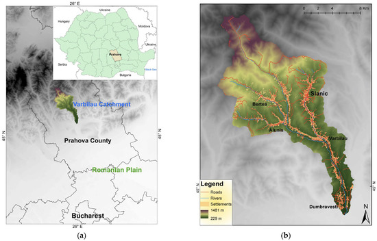
Figure 1.
The location of the Vărbilău catchment in Romania: (a) the location of the Vărbilău area in Prahova County; (b) road network and settlements inside the catchment.
The Vărbilău Basin, located in Prahova County (Figure 1a), has an area of 215 km2, being a small hydrographic basin. It is located at altitudes between 229 m in the south, near the confluence of the Vărbilău River with the Teleajen collector river, and 1481 m in the north [9]. The basin is framed by the Romanian Plain in the south and the Carpathian Mountains in the north. Most of the basin’s surface is represented by the alternation between hills and valleys, with gentle hills in the south and higher ones in the north [10]. The valleys are elongated, with an NW–SE arrangement in the north and center and N–S one in the basin’s south. The elongated shape and flat surface of the riverbeds favor flooding, while the steep slopes and circular shape of the sub-basins in the north favor rapid runoff of water on the slope [11]. Precipitation, together with the previously mentioned elements, favors hydrological phenomena. Floods occur either in the spring after the rapid melting of the snow, or in the months with higher precipitation, namely in May and June [12]. Moreover, there have been recent floods in the localities of Aluniş, Bertea, Vărbilău, and Ştefeşti, but also landslides in the Lutu Roşu area, which have destroyed the roads and completely isolated the village.
The ISU intervention centers (emergency points) that serve this area are Ploieşti (two centers), Câmpina, Vălenii de Munte, and Slănic (a smaller intervention center, the only one located right in the hydrographic basin area). The population that lives here comprises about 30,000 people [13]. The roads show a higher density in the area of the Vărbilău commune, the town of Slănic, Dumbrăveşti, and in the Ostrovu–Aluniş area (Figure 1b). The quality of the roads is somewhat better in the central area of these places, while towards the periphery, it decreases, as does the density. In the mountainous north and the high hilly areas, the density of roads is very low; they are almost non-existent.
3. Materials and Methods
Field observations, GIS (Geographic Information System) databases, and data from the Emergency Situations Inspectorate were utilized. GIS maps were developed using different tools from ArcMap 10.2.2. Initially, the databases were added and prepared for processing. The road network, the essential component used in the elaboration of this study, is line-type data, and comprises segments that have set travel speeds depending on the road quality [14]. Based on their length and speed, it was possible to calculate travel speeds on a road section in GIS [15]. The four intervention centers mentioned in the previous “study area” were added as point data. The information related to them was obtained from the Prahova Emergency Unit website (https://www.isuprahova.ro/) (accessed on 20 May 2023).
Travel time maps that take into account the time away from an emergency point were built, taking into account the road network. The obtained results made up a polygon database. Five time intervals were set (<10 min, 10–20 min, 20–30 min, 30–40 min, and >40 min). They will be presented in the Results section. It should be mentioned that on three of the travel time maps (Vălenii de Munte, Ploieşti, and Câmpina), the points represent the entry points for the emergency teams in the hydrographic basin.
Further, the polygons were transformed into raster data (a raster is made of pixels of different sizes; the smaller the pixel, the higher the quality) [16]. A general accessibility map of the Vărbilău catchment for the emergency units depending on the road network and the intervention centers was built with the help of the following formula using Raster Calculator [16]:
where R is the sum of the rasters of the travel time maps for each emergency point taking into account the road network (general accessibility map), MapS is the raster for Slănic, MapC is the raster for Câmpina, MapV is the raster for Vălenii de Munte, and MapP is the raster for Ploieşti.
Marks were awarded to each of the five travel time intervals: 5 for <10 min, 4 for 10–20 min, 3 for 20–30 min, 4 for 30–40 min, and 5 for >40 min [17]. Depending on the size of the intervention center, a multiplier was added to the formula [18]. No multiplier was added to Slănic because this is a small intervention center. No multiplier was added for Câmpina because even if there is a detachment, it is a center situated at the longest distance from the Vărbilău basin compared to the others (20 km). Also, the distance the team has to cross to reach the Vărbilău catchment is in a hilly and winding area, so it is more difficult to pass. A multiplier of “2” was added to Vălenii de Munte center because it is closer to the basin than Câmpina (only 5 km from the Varbilau basin). In the case of Ploieşti, the multiplier “4” was added because there are two very important detachments there (Ploieşti is the county capital) located at a distance of 12 km from the hydrographic basin [19]. A general accessibility map was obtained after using formula values from 8 to 28. A value of 8 means a small accessibility index, while 28 means a high index value. Using natural breaks in GIS (reclassification), five new intervals were set from 1 to 5 (Table 1).

Table 1.
General accessibility value reclassification.
Through a decision factor in which conditional statements were used, the best-served areas (the ones with under 10 min) were identified and a map was obtained [20]. Thus, the condition was defined using the four travel maps:
where Dt is the decision factor and Con is the condition.
The condition reads as follows: If MapS has an area equivalent to “under 10 min”, then it is given a value of 1. In this way, only the area with the value “under 10 min” is displayed, which means time accessibility is very good. In order to include all four areas, “and” is added between conditions. To differentiate the accessibility of each of the areas, random values of 1, 2, 3, and 4 were added. The number of best-served settlements was determined based on a settlement database.
The obtained maps and other results will be presented in the next chapter.
4. Results
Figure 2a shows that, from the point of view of accessibility, the best-served area (under 10 min) by the Slănic intervention center is located in the northeast of the basin, around the point. Figure 2b shows the area that the Câmpina center best serves. Whole areas in the center, north, and south are poorly served due to the long distance (over 40 min). Figure 2c shows the area served by the center from Vălenii de Munte. It can be seen that a very small zone is very well served (under 10 min). Figure 2d indicates that the best-served area by the two intervention centers in Ploiesti is in the south. The shape of the areas was influenced by the times required to cross a road section and the distance from the intervention point.
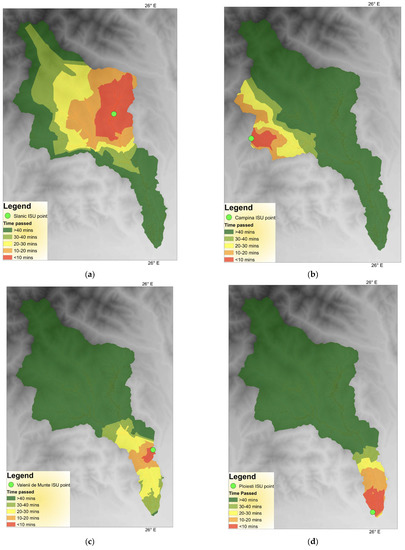
Figure 2.
Travel time maps: (a) accessibility from Slănic; (b) accessibility from Câmpina; (c) accessibility from Vălenii de Munte; (d) accessibility from Ploieşti.
The general accessibility map (Figure 3a) was obtained based on travel time maps. The best-served areas (4 and 5) are in the south in the area of Dumbravesti due to the high density of roads, their good quality, and the proximity to the centers of Ploieşti and Vălenii de Munte. The moderately served areas (3) are in the central and north-eastern parts and a few in the west as a result of the smaller importance of the intervention centers (Slănic), the greater distance of the Câmpina center from the basin, and the lower road density in the peripheral areas of certain localities (Slănic, Aluniş, and Vărbilău villages). The poorly served areas (2) include the communes of Bertea and Ştefeşti, and part of the commune of Vărbilău, the reason being the low density of the roads, the poor quality of the roads (travel speed is thus lower), and the greater distance from the intervention centers. The mentioned villages are located in hilly areas [21]. The least served areas, some inaccessible, include the mountainous area in the north with very steep slopes and certain hills bordering the Vărbilău commune to the west and east (the central area of the basin).
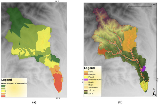
Figure 3.
Accessibility maps of Vărbilău catchment: (a) general accessibility index map; (b) best-served areas according to conditional statements.
In the situation of the best-served areas in terms of travel time, depending on the conditional statements used in the situation of the four travel time maps, Figure 3b shows that the best-served area is the Slănic area (in orange) served by the intervention center with the same name. This is the only town in the Vărbilău basin in which the density and quality of the roads are relatively good.
The smallest zone of the best-served areas is represented by the one under the influence of the center of Vălenii de Munte (in purple). This study used only time to determine the best-served areas (those with a journey of fewer than 10 min). Table 2 indicates that in the Slănic area, 3913 buildings are very well served, representing 18.5% of the total number of buildings, meaning that the intervention teams from Slănic arrive at that area in less than 10 min. The area served by the Vălenii de Munte center includes only 144 buildings—0.68% of the total number of buildings. It is important to note that the time starts from the entry point of the teams in the Vărbilau Basin to a settlement. Besides the time inside the basin, the crews need some extra minutes to travel from the center to the limits of the Vărbilau catchment [22]. The same applies to the Câmpina and Ploieşti intervention centers, but not Slănic, located inside the catchment.
Table 2.
Number of buildings located in the best-served area (index 5).
5. Conclusions
The capacity to intervene can be decisive in reducing the negative impact of floods and saving lives. It can be seen that from the viewpoint of time accessibility depending on the road network, not taking into account other factors, that the best-served areas are that of Slănic city, a small area in the west of the hydrographic basin, and two areas in the south.
Regarding general accessibility, factors such as the proximity of ISU intervention centers and their importance were included. Thus, it turned out that the area in the south (Dumbrăveşti area) is the best-served, while the extreme north is the least served due to the low density of roads and their poor quality (forest roads). In many areas, there is no way of communicating, with the slopes being steep and the mountains being mostly forested.
The situation can be improved by establishing new centers and equipping existing ones, such as Slănic, which is a small intervention point. Also, improving the quality of roads and building new routes in less accessible areas can increase travel times.
Author Contributions
Conceptualization, C.P. and C.Ș.D.; methodology, C.P. and A.B; software, C.P.; validation, A.B. and C.Ș.D.; formal analysis, A.B. and C.Ș.D.; investigation, C.P., A.B. and C.Ș.D.; resources, C.P.; data curation, C.P.; writing—original draft preparation, C.P. and A.B.; writing—review and editing, C.Ș.D.; visualization, C.P.; supervision, A.B.; project administration, A.B.; funding acquisition, C.P. All authors have read and agreed to the published version of the manuscript.
Funding
The research received fundings from the Doctoral School of Technical University of Civil Engineering, internal grants for Ph.D. students.
Institutional Review Board Statement
Not applicable.
Informed Consent Statement
Not applicable.
Data Availability Statement
Data will be available on request.
Conflicts of Interest
The authors declare no conflict of interest.
References
- Toroimac, G.I.; Zaharia, L. Using Pressure and Alteration Indicators to Assess River Morphological Quality: Case Study of the Prahova River (Romania). Water 2015, 7, 2971–2989. [Google Scholar] [CrossRef]
- Hamouda, M.F.; Pasquero, C. European extreme participation: The effects of spatio-temporal resolution of the data. Weather Clim. Extrem. 2021, 33, 100337. [Google Scholar] [CrossRef]
- Croitoru, A.E.; Piticar, A.; Burada, D.C. Changes in precipitation extremes in Romania. Quatern. Int. 2016, 415, 325–335. [Google Scholar] [CrossRef]
- Taniguachi, E.; Fereira, F.; Nicholson, A. A Conceptual Road network Emergency Model to Aid Emergency Preparedness and Response Decision-Making in the Context of Humanitarian Logistics. Proced. Soc. Behav. Sci. 2012, 39, 307–320. [Google Scholar] [CrossRef]
- Rohr, A.; Priesmeier, P.; Tzavella, K.; Fekete, A. System Criticality of Road Network Areas for Emergency Management Services–Spatial Assessment Using a Tessellation Approach. Infrastructures 2020, 5, 99. [Google Scholar] [CrossRef]
- Arrighi, C.; Pregnolato, M.; Dawson, R.J.; Castelli, F. Preparedness against mobility disruption by floods. Sci. Total Environ. 2019, 654, 1010–1022. [Google Scholar] [CrossRef]
- Somenahalli, S.V. Road Network Accessibility and Socio-economic Disadvantage Across Adelaide Metropolitan Area. Transp. Dev. Econ. 2016, 2, 15. [Google Scholar] [CrossRef]
- Sahytia, K.S.; Csrk, P. GIS-Based Urban Road Network Accessibility Modeling Using MLR, ANN and ANFIS Methods. Transp. Telecommun. 2021, 22, 15–28. [Google Scholar]
- Ghinea, D. The Geographical Encyclopedia of Romania; Editura Enciclopedică: Bucharest, Romania, 2000. (In Romanian) [Google Scholar]
- Velcea, V. The Geography of Romanian Carpathians and Sub-Carpathians; Editura Didactică şi Pedagogică: Bucharest, Romania, 1982. (In Romanian) [Google Scholar]
- Roșu, A. The Physical Geography of Romania; Editura Didactică și Pedagogică: Bucharest, Romania, 1980. (In Romanian) [Google Scholar]
- Drobot, R. Lessons of Hydrology and Hydrogeology; Editura Didactică și Pedagogică: București, Romania, 2020. (In Romanian) [Google Scholar]
- Erdeli, G.; Dumitrache, L. The Population Geography; University Publishing: Bucharest, Romania, 2010. (In Romanian) [Google Scholar]
- Toma, M.G.; Ungureanu, R.D.; Dicu, M. GIS, a tool for improving the road network management. IOP Conf. Ser. Earth Environ. Sci. 2021, 664, 012103. [Google Scholar] [CrossRef]
- Safeer, M.; Anbuudayasankar, S.P.; Kartik, B.; Ganesh, K. Analyzing Transportation and Distribution in Emergency Humanitarian Logistics. Procedia Eng. 2014, 97, 2248–2258. [Google Scholar] [CrossRef]
- Caniupan, M.; Torres-Aviles, R.; Gutierrez-Bunster, T.; Lepe, M. Efficient computation of map algebra over raster stored in the k2-acc compact data structure. GeoInformatica 2022, 26, 95–123. [Google Scholar] [CrossRef]
- Sedeghi-Niaraki, A. Real world representation of a road network for route planning in GIS. Expert Syst. Appl. 2011, 38, 11999–12008. [Google Scholar] [CrossRef]
- Malczewski, J. On the Use of Weighted Linear Combination Method in GIS: Common and Best Practice approaches. Trans. GIS 2002, 4, 5–22. [Google Scholar] [CrossRef]
- Slopek, J.; Netzel, P. Comparison of different implementations of a raster map calculator. Comput. Geosci. 2021, 154, 104824. [Google Scholar]
- Eastman, J.R.; Kyen, P.A.K.; Toledano, J.; Jin, W. GIS and decision making. Photogramm. Eng. Remote Sens. 1995, 61, 539–547. [Google Scholar]
- Shrestha, J. Rural Road Network Decision model for Hilly Regions of Nepal. J. Adv. College Eng. Manag. 2018, 4, 51–64. [Google Scholar] [CrossRef]
- Graur, D.S.; Efros, V. GIS analysis or road network accessibility for emergencies managed by firefighters (case study–Suceava county, Romania). Acta Geobalc. 2017, 3, 65–70. [Google Scholar] [CrossRef]


Disclaimer/Publisher’s Note: The statements, opinions and data contained in all publications are solely those of the individual author(s) and contributor(s) and not of MDPI and/or the editor(s). MDPI and/or the editor(s) disclaim responsibility for any injury to people or property resulting from any ideas, methods, instructions or products referred to in the content. |
© 2023 by the authors. Licensee MDPI, Basel, Switzerland. This article is an open access article distributed under the terms and conditions of the Creative Commons Attribution (CC BY) license (https://creativecommons.org/licenses/by/4.0/).