Abstract
Uranium production tailing ponds in Kamyanske (Ukraine) are objects of increased radioecological danger. Violation of the stability and integrity of containment dams threatens the uncontrolled spread of radionuclides. The purpose of this study is to comprehensively assess the factors affecting the technical condition and environmental safety of the Sukhachivske tailing dam. The study included a visual inspection and detailed geophysical work using the natural pulse electromagnetic field of the Earth (NPEMFE) method. This method was chosen to identify hidden filtration paths and stress zones in the body of the earth dam. An analysis of the spatial distribution of waterlogging, filtration, and fissuring in the hydraulic structure was performed. Based on the results of the NPEMFE survey, six zones with varying degrees of waterlogging and stress–strain states of the structure were identified. The presence of externally unmanifested filtration paths and suffusion areas was established, and a tectonic scheme of fracture development in the dam body was compiled. A correlation was found between the dominant azimuths of crack extension (70–79° and 350–359°) and the directions of regional tectonic lineament zones, at the intersection of which the tailing pond is located. It has been established that modern tectonic movements along fault zones create zones of permeability, which serve as primary pathways for water filtration and further development of suffusion. This conclusion introduces a new tectonic feature for risk diagnosis and monitoring of similar hydraulic structures.
1. Introduction
The management of mining waste, in particular tailing ponds, is one of the most pressing environmental problems in the world [1,2,3]. An integrated assessment of risks and reliability in their design, operation, and conservation is fundamental to preventing environmental disasters [4,5,6]. Ensuring long-term stability, especially for those storage facilities containing radioactive uranium waste, is a subject of deep scientific concern due to the high risk of radionuclide migration into the environment [7,8,9].
This global problem is particularly critical in Ukraine [10], in particular in the industrial hub of Kamyanske (formerly Dniprodzerzhynsk) in the Dnipropetrovsk region, where more than 50 industrial enterprises operate. The greatest environmental threat is posed by the uranium legacy of the former Prydniprovsky Chemical Plant (PCP). This waste was accumulated between 1948 and 1991. During the operation of the Prydniprovsky chemical plant, nine tailing dumps were created, containing about 42 × 106 tons of radioactive waste with a total activity of 3.2 × 10¹⁵ Bq (86,000 Ci) [11,12].
The environmental and radiation hazards posed by these facilities are extreme. The Sukhachivske tailing pond (S) is one of the largest. Its first, unsealed section contains 19 million tons of waste (volume—8.6 million m3) with a total activity of 7.1 × 10¹⁴ Bq. It remains a powerful source of constant environmental pollution due to dust (23.9 tons/year) and radon (1.86 × 10¹³ Bq/year) emissions to the atmosphere [11,13,14]. In this context, ensuring the physical stability of containment dams is a priority for radiation safety. Similar catastrophic dam failures recorded around the world, for example, in Turkey [15], underscore the vital need for accurate risk assessment and prevention of catastrophic releases of accumulated radionuclides into the Dnieper River basin.
Previous studies at PCP facilities [8,12,14] and visual inspections have focused primarily on monitoring and diagnosing existing damage. However, although these studies are important for current operations, they mainly record the consequences (suffusion and cracks) rather than the root causes that influence their spatial development. To date, the question remains open as to whether these degradation processes are random (caused only by surface runoff) or whether they are a result of deep, controlling geological factors.
The novelty of this work lies in the transition from simply stating the damage to analyzing the fundamental geological factors. We put forward and test the hypothesis that the development of filtration and fracturing zones in the dam body is controlled not only by natural factors such as climate change and seismicity, but also by the tectonic features of the tailing pond location areas.
The aim of the study is to identify and analyze natural factors, in particular tectonic ones, that influence the development of hazardous processes, the formation of filtration–suffusion zones, and the reduction in the environmental safety of the Sukhachivske tailing dam.
2. Materials and Methods
2.1. Characteristics of the Research Object
The Sukhachivske tailing pond of the ravine-beam type (total area 491.43 ha) is located 14 km from the city of Kamyanske in a branch of the Rozsoluvata Ravine [11,13]. The total length of the tailing pond is 4.8 km. The object of our detailed study was the dam of the surface runoff storage pond of the first section of the tailing pond (Figure 1). The first section of the tailing pond occupies the upper part of the ravine and was created in 1967 by blocking the ravine with an earth dam. At the top of the 16.8 m high embankment runs the Dnipro–Kamyanske highway with a road width of 20 m. The width of the embankment at the crest is 79 m. The dam was built from local loam, loam, and sandy loam, compacted layer by layer. The slopes of the embankment are grassed. Behind the embankment is a water collection pond, which also serves as a water reservoir to cover radioactive waste in case of drying. The location of the structures and the geological profile are shown in Figure 2.
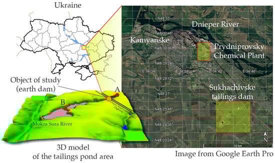
Figure 1.
Overview map of the research site location (dam coordinates 48°26′03″ N; 34°45′24″ E).
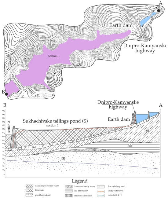
Figure 2.
Terrain relief and geological profile along the axis of the first section of the “Sukhachivske” tailing pond (compiled by the authors based on data [16]).
In 2004, significant washouts and cracks were already observed at the facility, which required recultivation work; however, this did not completely solve the problem.
The first section of the tailing storage facility was used from 1968 to 1983 for storing uranium production waste and phosphogypsum. In total, it contains ~19 million tons of waste with a volume of 8.6 million m3 and a total activity of 7.1 × 10¹⁴ Bq. The solid phase of the waste consists of sandy loam, less frequently loam, silty and sandy, and sand ranging from silty to medium-grained. The chemical composition of the waste is formed by the main minerals of the original uranium ore (quartz, feldspars, hydromica, and kaolinite) in combination with chemical compounds used in ore processing (sulfuric and nitric acids) and products of neutralization of the resulting acidic environment (lime). The section is limited by an earth dam 900 m long and 29 m wide at the crest, with a dam height of 32 m.
The second section of the tailing pond is located below and adjacent to the first. It was commissioned in 1984 and is currently in operation. It occupies the lower half of the beam, formed by a dam that blocks the beam and embankments that surround the area in use. The dam is 760 m long, 6 m wide at the crest, and about 41 m high, with embankment dams being 11 m high. The design capacity is 22.5 million m3 of waste. The surface layer of solid sludge consists of non-radioactive waste from chemical production—phosphogypsum—which covers the uranium production waste with a layer of up to 4–5 m.
Uranium production waste deposited under phosphogypsum has a natural uranium content of 20–30 mg/kg and is characterized by a specific activity of uranium-238 ranging from 187 to 427 Bq/kg, thorium-230 from 2970 to 8404 Bq/kg, radium-226 from 1218 to 5668 Bq/kg, and lead-210 from 802 to 4053 Bq/kg.
Both sections of the tailing storage facility are partially equipped with anti-filtration screens, surface ditches, and observation wells, and are under constant supervision by regulatory authorities. The presence of a surface layer above the radioactive waste prevents its dusting, but there is a risk of its destruction due to the sudden inflow of large volumes of water from the accumulation pond located at the head of the ravine. It is the dam of this pond that has been selected as the object of geophysical research.
2.2. Methodology for Assessing the Technical Condition of the Dam
The research was conducted in two stages: visual inspection and geophysical surveying. Visual inspection: In the first stage, a detailed visual inspection of the dam was carried out [17]. This allowed us to record numerous external signs of degradation, such as suffusion funnels, surface collapses, and underground suffusion channels up to 7 m long and 2–2.5 m in diameter (Figure 3). It was noted that despite the absence of traces of active surface erosion, the presence of large suffusion forms indicates a constant inflow of water through hidden filtration zones.
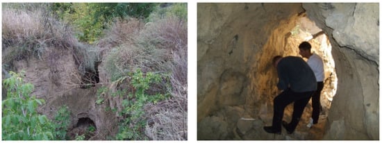
Figure 3.
Manifestation of suffusion processes in the dam of the Sukhachivske tailing pond. Own photos.
Geophysical surveying: Studies were conducted using the natural pulse electromagnetic field of the Earth (NPEMFE) method. To identify waterlogged areas and areas of hidden water filtration through the dam body, a non-destructive geophysical method using the natural pulse electromagnetic field of the Earth (NPEMFE) was used [18]. This method is also recommended by the Ukrainian state standard [19]. The NPEMFE method is a variation of the spontaneous polarization (SP) method, which is internationally recognized for monitoring various engineering–geological processes and flows [20,21]. The use of geophysical methods (including SP and electrical tomography) is a proven effective practice for monitoring filtration processes in embankment dams and identifying water solution seepage paths [22,23]. Their use is critical for assessing the integrity of engineering structures [24].
The pulse flow density of the NPEMFE magnetic component was recorded using the “SIMEIZ” (Figure 4) geophysical system. The apparatus consists of an electromagnetic pulse registration module, a portable data storage unit, and a three-axis high-sensitivity antenna system. The device operates within a low-frequency range of 1–50 kHz, enabling continuous signal acquisition with a sampling frequency of at least 10 Hz (0.1 s intervals). During the survey, remote antennas were positioned 0.2–0.4 m above the structure’s surface. Geophysical surveying was carried out on the surface of the dam on a square grid with a 3 × 3 m step using a device with three antennas (along and across the dam, as well as one antenna directed vertically downward). The field survey covered the protective part of the dam, the area between the road and the fence, and the roadside on the side of the storage pond (Figure 5).
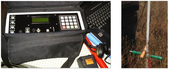
Figure 4.
General view of the “SIMEIZ” device and antenna placement for NPEMFE signal detection.
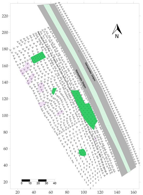
Figure 5.
Map of actual NPEMFE survey data for the upper dam of the Sukhachivske tailing pond. Green color—areas of tree and shrub vegetation; purple color—areas of surface suffusion; numbers indicate NPEMFE survey points.
The interpretation of maps and graphs is based on the feature of the NPEMFE field—a decrease in the density of the magnetic component of the electromagnetic field in areas that are compacted, fractured, or waterlogged. The appearance of the NPEMFE field pattern is also used for the maps. Thus, solid, monolithic rocks and materials are characterized by a highly differentiated field, with many isolines and a wide range (amplitude) of values. For fractured areas, the field pattern is more consistent but also differentiated, although to a lesser extent. Waterlogged areas have a calm, “blurred” field pattern, with a small number of isolines, the values of which are at low levels.
Thus, two main features form the basis for distinguishing filtration flow directions. The first is the presence of areas where the soil materials that make up the dam are saturated. Experimental studies [21,25,26] have shown that when cracks form and soils become waterlogged, there is a decrease in the density of the NPEMFE magnetic component pulse flow, so the identification of these zones is quite reliable. Second, if there is a height gradient, a filtration flow will form. The paths of maximum filtration can be determined by analyzing the nature of the isoline pattern of the pulse flow range—these are areas of reduced values, “sandwiched” between elevated ones, or the axial parts of areas with a low-contrast field, as opposed to a high-contrast one. The direction of the filtration flow is determined based on the geological section. It should be noted that the figures show the plan position of the filtration zones; their depth, speed, and volume of filtration must be determined using other methods. The NPEMFE method is not capable of performing this, as it is qualitative rather than quantitative.
The following features were used as indicators to identify fractures and fragments of disruptive disturbances: anomalies in the form of “steps,” local linear anomalies, disturbances in the regular behavior of isolines, and boundaries of areas with different field patterns.
3. Results
3.1. Zoning of the Dam Body Based on NPEMFE Data
Based on the results of the geophysical surveying, maps of NPEMFE pulse density were created (Figure 6). A joint analysis of the maps and diagrams allowed us to identify six zones that differ in their geophysical characteristics and degree of waterlogging (Figure 7):
- Zone 1. It is characterized by low NPEMFE values, indicating already formed, stable filtration areas. Externally, this manifests itself in the form of suffusion craters and depressions.
- Zone 2. It has elevated NPEMFE values. This may indicate either an area with low water saturation (after repair) or, more likely, the development of landslide processes, where the massif is in a stressed–deformed state.
- Zone 3. It has the lowest NPEMFE values. This indicates strong waterlogging, which is also confirmed by the significant amount of vegetation and reed thickets.
- Zone 4. An area with elevated values, which has weak waterlogging along the ground road. This is probably due to its constant compaction as a result of the passage of motor vehicles used by the tailing pond security service.
- Zone 5. It is probably related to defects in the waterproofing of the concrete channel that drains water from the road, causing the rocks to become saturated.
- Zone 6. It is located between the channel and the motorway, characterized by waterlogging (reed beds). Areas of reduced NPEMFE values adjacent to the road indicate possible filtration and suffusion directly under the motorway.

Figure 6.
Interpretation scheme for NPEMFE surveys. Blue dotted lines and numbers in circles indicate zone boundaries and numbers (explanation in the text). Blue arrows indicate the directions of water filtration through the dam body. The red dotted line indicates the predicted areas of waterlogging.


Figure 7.
Generalized interpretation scheme for NPEMFE images. Green indicates areas of vegetation growth, purple indicates areas of surface suffusion. Blue dotted lines and numbers in circles—boundaries and numbers of zones (explanation in the text). Blue arrows—directions of water filtration through the dam body. Red dotted line—predicted waterlogging zones.

3.2. Analysis of Fissuring
To establish the characteristics of crack distribution in the waterlogging and filtration zones on the dam, determined based on NPEMFE survey data, using known signs of disruptive disturbances in geophysical fields, fracture zones were identified, and their azimuths of extension were determined (Table 1). The visual distribution of the fracture systems is shown in a bar chart (Figure 8). It can be seen that the following azimuths of extension are dominant:
- →
- diagonal cracks: 70–79° (±5°);
- →
- meridional: 350–359° (±5°);
- →
- sublatitudinal: 290–299° (±5°).

Table 1.
Azimuths of crack extension in the flooded areas of the Sukhachivske tailing dam.
Table 1.
Azimuths of crack extension in the flooded areas of the Sukhachivske tailing dam.
| Crack Group Number | Extension Azimuth Interval, Degrees | Number of Cracks of the Corresponding Azimuth | Relative Frequency of Occurrence, % |
|---|---|---|---|
| 1 | 20–29 | 1 | 2.1 |
| 2 | 30–39 | 5 | 10.6 |
| 3 | 70–79 | 11 | 23.5 |
| 4 | 80–89 | 5 | 10.6 |
| 5 | 290–299 | 9 | 19.2 |
| 6 | 330–339 | 5 | 10.6 |
| 7 | 340–349 | 2 | 4.3 |
| 8 | 350–359 | 9 | 19.1 |
| Total | - | 47 | 100.0 |

Figure 8.
Diagram of the fracturing of the Sukhachivske tailings.
Figure 8.
Diagram of the fracturing of the Sukhachivske tailings.

These fracture zones are the main pathways for water movement, which was confirmed by comparison with the directions of solution movement from the storage pond (shown in Figure 6 and Figure 7).
The obtained results indicate the danger of dam failure and the release of water masses that could form a mudflow. This flow is capable of destroying the protective layer covering the waste (see Figure 2), which will lead to its exposure, spillage across the area of the first section, and release into the atmosphere. We do not consider the risk of destruction of the lower retaining dam, since the capacity of the first section is capable of completely absorbing the incoming water. Therefore, there is no reason to talk about the destruction of the main retaining dam.
4. Discussion
4.1. Identification of the Tectonic Factor
The key result of this work is the established correlation between the dominant azimuths of fracturing (70–79°, 290–299°, and 350–359°), identified by the NPEMFE method, and the directions of regional lineament zones (LZ) is a direct empirical confirmation and development of the neotectonic models proposed by Yuskiv [27] and Verkhovtsev [28] for this area (Figure 9). They established the theoretical presence of lineament zones of the intermediate diagonal (74–80° ⊥ 345–350°), the dominant orthogonal system 0 ⊥ 90 (±5)°; intermediate diagonal system 25–300 ⊥ 295–300°. Thus, our study proves for the first time that these zones function as active pathways for hydraulic degradation of the engineering structure body.
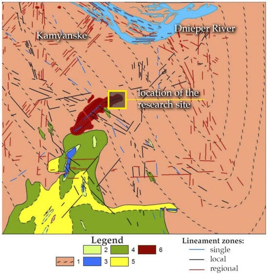
Figure 9.
Geological and petrographic map of the Sukhachivske tailing pond area of Precambrian crystalline rocks and its comparison with linear structures identified as active at the latest stage of development [27,29]. Legend: 1—plagiogranites and migmatites; 2—talc–actimite–chlorite schists; 3—serpentinites; 4—epidiabas, amphibolites, and amphibolite-derived schists; 5—quartz-chlorite and sericite–chlorite schists; and 6—radioactive waste Sukhachivske tailings.
Our data show that the dam, located at the intersection of three LZs, is affected by modern tectonic movements (+4 mm/year [29]), which form inherited zones of increased permeability in its body. This may indicate that the development of waterlogging and filtration zones is associated with the formation of cracks spatially confined to lineament zones. It is these fracture zones that serve as primary conduits for water and “channels” for further filtration, suffusion, which is radically different from previous ideas about degradation solely under the influence of surface waters.
4.2. Comparison and Generalization
These conclusions correlate with similar data obtained at another tailing pond, Dniprovske [30]. This suggests that tectonic control is not a local anomaly of Sukhachivske, but a systemic, regional risk factor for all hydraulic structures of the PCP located at the intersections of fault structures.
As other studies show [31,32,33], geological factors, including tectonic factors, are among the most important for the stability and reliability of dams. Our work complements these data by highlighting the specific neotectonic contribution, similar to how active faults affect hydraulic structures in other seismically active regions [34,35,36]. Climatic [37] and seismic [34] factors act as secondary “triggers”: they only intensify and accelerate destruction in directions already set by tectonic movements. This assessment of the tectonic factor is an important addition to standard seismic assessments (DSHA/PSHA), which are the norm for such facilities [32]. Infrastructure damage during seismic events is often controlled by existing geological structures.
4.3. Reassessment of Environmental and Radiation Risks
The establishment of an active tectonic factor fundamentally changes the risk assessment paradigm for this facility in several ways:
- From static to dynamic risk. The tailing pond of radioactive waste is not a static object that slowly degrades under the influence of erosion. It is a dynamic system that is under constant geological tectonic influence, as well as under the action of alternating stresses from transport movement. Studies of disasters such as the dam breach in Brumadinho [35] have shown that geological deformations of the earth’s surface are direct precursors to destruction.
- Increased likelihood of sudden collapse. The risk lies not so much in gradual filtration (which also pollutes groundwater [8,12] and is known in international terminology as internal erosion [6,36]) as in sudden loss of stability (caused by a seismic shock [34] or extreme precipitation [37]) along a tectonically weakened zone.
- Ineffectiveness of superficial repairs. Reclamation and “cosmetic” repair and restoration work (as in 2004) only have a temporary effect [27,28]. Such measures do not eliminate the underlying tectonic cause. Water will inevitably find new paths along the same areas of stress and crack deformation.
Therefore, our research proves that monitoring and any measures to preserve such an object must necessarily take into account the structural–tectonic position of the tailing pond. This approach significantly strengthens management decisions regarding reliability and standards in assessing the safety of many mega-projects.
It should be noted that the proposed approach is focused on spatial–qualitative diagnostics. The identification of fracture zones and their correlation with tectonic lineaments provides a “map of vulnerability”. While this study does not aim to calculate the exact volume of leakage, it provides the essential structural framework for such calculations. We would like to emphasize that this territory is not tectonically active, and there are no earthquakes with significant consequences here. This creates a false sense of confidence in the stability of hydraulic structures and reduces attention to tectonic factors that may affect them. However, even long-term low-amplitude tectonic movements lead to the development of cracks in the body of such structures, which can subsequently compromise their reliability. Taking into account regional tectonic features will allow attention to be drawn to those objects that are located precisely at the intersections of faults of different orientations.
The NPEMFE results act as a screening phase in a multi-level risk management system. By pinpointing the zones where the signal density drops significantly (e.g., Zone 3 and Zone 6 in Figure 6), we define the exact locations where high-precision geotechnical instruments should be installed for subsequent quantitative monitoring of pore pressure and tracer migration.
The tectonic control observed at the Sukhachivske site aligns with global experiences in other seismically and tectonically active regions. For instance, the catastrophic failure of the Brumadinho tailing dam in Brazil (2019) was preceded by subtle internal deformations linked to the complex geological structure. Similarly, studies of tailing facilities in Turkey and Chile demonstrate that even in the absence of major earthquakes, slow creep along active fault planes can increase hydraulic conductivity by orders of magnitude [10]. Our findings confirm that for the Precambrian crystalline shields (like the Ukrainian), the intersection of lineament zones creates permanent “weak points” that are more critical for long-term stability than surface erosion alone
5. Conclusions
The study found that the environmental safety of the Sukhachivske radioactive waste tailing dam is determined by a complex of interrelated natural and man-made factors. The main findings of the study include the following:
- A comprehensive geophysical study using the NPEMFE method and a visual inspection of the Sukhachivske tailing dam allowed us to identify and map six zones with varying degrees of waterlogging and to establish the presence of hidden filtration paths and powerful suffusion channels that threaten the integrity, stability, and reliability of the structure. The potential destruction of the dam poses a risk of erosion of the surface protective screen of radioactive waste in the first section of the tailing pond. However, this scenario will not lead to the loss of overall structural stability of the facility or systemic collapse of the entire tailing pond.
- The key scientific result is the proof that degradation processes in the dam body depend on active tectonic factors. For the first time, it has been empirically proven that the dominant azimuths of fracturing (70–79°, 290–299°, and 350–359°) coincide with the directions of regional lineament zones, at the intersection of which an environmentally hazardous facility is located. At the same time, other natural factors (climatic—increased intensity of torrential rainfall; seismic—minor fluctuations up to 6 points) act as secondary “triggers” that accelerate filtration deformations and destruction of the structure in areas initially weakened by tectonic movements.
- The practical significance of the work lies in a fundamental reassessment of risks, since the facility should be considered as a dynamic system prone to sudden loss of stability. The results prove that any engineering measures and environmental and radiation safety monitoring systems for such tailing ponds must include a structural–tectonic analysis of the territory.
- The phenomenon of tectonic control over tailing dam degradation is not site-specific but represents a systemic risk for hydraulic structures located on ancient crystalline shields. While regional differences exist—ranging from high-magnitude seismic triggers in orogenic belts to slow neotectonic reactivation on stable platforms—the fundamental mechanism remains the same: tectonic lineaments act as primary conduits for internal erosion. This highlights the global necessity of including structural–tectonic mapping in the mandatory safety protocols for radioactive waste storage facilities worldwide.
Author Contributions
Conceptualization, O.O., D.P., L.R. and H.H.; methodology, O.O. and D.P.; software, D.P. and H.H.; investigation, O.O., D.P., L.R. and H.H.; resources, O.O. and D.P.; writing—original draft preparation, O.O., D.P., L.R. and H.H.; writing—review and editing, O.O., D.P., L.R. and H.H.; visualization, D.P. and H.H. All authors have read and agreed to the published version of the manuscript.
Funding
This research received no external funding.
Data Availability Statement
The original contributions presented in this study are included in the article. Further inquiries can be directed to the corresponding author.
Acknowledgments
The authors are thankful to the State Enterprise “Barrier” for the opportunity to access the site and work with the reports on previous studies.
Conflicts of Interest
The authors declare no conflicts of interest.
References
- Lottermoser, B. Mine Wastes: Characterization, Treatment and Environmental Impacts; Springer: Berlin/Heidelberg, Germany, 2010. [Google Scholar] [CrossRef]
- WISE (World Information Service on Energy) Uranium Project: Chronology of Major Tailings Dam Failure. 2023. Available online: https://www.wise-uranium.org/mdaf.html (accessed on 26 January 2026).
- Koucham, M.; Khalil, A.; Mouhagir, L.; Zouhri, L.; El Adnani, M. Comprehensive Assessment of Environmental Behavior of Mine Tailings for Sustainable Waste Management and Mitigation of Pollution Risks. Water 2024, 17, 43. [Google Scholar] [CrossRef]
- Gao, T.; Qin, Z.; Yang, R.; Li, Q.; Geng, C.; Zhang, J.; Chen, Z. Study on Risk Assessment and Risk Prevention of Dam Failure During the Operation Period of Tailings Pond. Buildings 2025, 15, 2833. [Google Scholar] [CrossRef]
- Zare, M.; Nasategay, F.; Gomez, J.A.; Moayedi Far, A.; Sattarvand, J. A Review of Tailings Dam Safety Monitoring Guidelines and Systems. Minerals 2024, 14, 551. [Google Scholar] [CrossRef]
- Rodríguez-Pacheco, R.; Butlanska, J.; Oliva-González, A.O. Geotechnical and Hydrogeological Zonation of Tailings Storage Facilities: Importance for Design, Construction, Operation, and Closure. Minerals 2025, 15, 105. [Google Scholar] [CrossRef]
- Camus, H.; Little, R.; Acton, D.; Agüero, A.; Chambers, D.; Chamney, L.; Daroussin, J.L.; Droppo, J.; Ferry, C.; Gnanapragasam, E.; et al. Long-term contaminant migration and impacts from uranium mill tailings. J. Environ. Radioact. 1999, 42, 289–304. [Google Scholar] [CrossRef]
- Rudakov, D.; Pikarenia, D.; Orlinska, O.; Rudakov, L.; Hapich, H. A predictive assessment of the uranium ore tailings impact on surface water contamination: Case study of the city of Kamianske, Ukraine. J. Environ. Radioact. 2023, 268–269, 107246. [Google Scholar] [CrossRef]
- Neposhyvailenko, N.; Gulyaev, V.; Gritsan, Y.; Huba, O. Geoinformation modeling of radioactive contamination of territories on the example of mines of the “ShidGSK” mining and processing plant. Biosyst. Divers. 2024, 32, 168–173. [Google Scholar] [CrossRef]
- Bugai, D.; Avila, R. Scenarios and Pathways of Radionuclide Releases from Near-Surface Waste Disposal Facilities: A Brief Overview of Historical Evidence. Nucl. Radiat. Saf. 2020, 3, 21–27. [Google Scholar] [CrossRef]
- IAEA. Radiological Conditions in the Dnieper River Basin: Assessment by an International Expert Team and Recommendations for an Action Plan; International Atomic Energy Agency: Wien, Austria, 2006.
- Zanoz, B.Y.; Bugai, D.O. Modeling of long-term radiological and toxicological impacts of the uranium mill tailings on groundwater and surface water. Nucl. Phys. At. Energy 2024, 25, 277–288. [Google Scholar] [CrossRef]
- Voitsekhovitch, O.; Soroka, Y.; Lavrova, T. Uranium mining and ore processing in Ukraine—Radioecological effects on the Dnipro River Water Ecosystem and human health. Radioact. Environ. 2006, 8, 206–214. [Google Scholar] [CrossRef]
- Kovalets, I.V.; Asker, C.; Khalchenkov, A.V.; Persson, C.; Lavrova, T.V. Atmospheric dispersion of radon around uranium mill tailings of the former Pridneprovsky Chemical Plant in Ukraine. J. Environ. Radioact. 2017, 172, 173–190. [Google Scholar] [CrossRef]
- Ozcan, N.T.; Ulusay, R.; Isik, N.S. A study on geotechnical characterization and stability of downstream slope of a tailings dam to improve its storage capacity (Turkey). Environ. Earth Sci. 2012, 69, 1871–1890. [Google Scholar] [CrossRef]
- Anishchenko, O.L. Research, Estimation and Forecasting of Level of Environmental Contamination in the Area of the Stores of Radioactive Waste Products—Manuscript. The Thesis for the Scientific Degree of Candidate (PhD) of Geographical Sciences on Speciality 11.00.11—Constructive Geography and Rational Use of Natural Resources. Ph.D. Thesis, Kharkiv Karazin National University, Kharkiv, Ukraine, 2004; 176p. Available online: https://uacademic.info/ua/document/0404U003516 (accessed on 26 January 2026).
- Pikarenia, D.; Orlinska, O.; Rudakov, L. Comprehensive visual survey as a mandatory tool for safe operation of tailings. In Proceedings of the International Scientific Conference “MININGMETALTECH 2023—The Mining and Metals Sector: Integration of Business, Technology and Education”; Riga, Latvia, 29–30 November 2023, Baltija Publishing: Riga, Latvia, 2023; Volume 2, pp. 211–214, (In Ukrainian). [Google Scholar] [CrossRef]
- Chepurnyi, V.; Liash, S.; Hrytsai, O.; Dobrovolska, Z. Improvement of the device’s design for increasing the efficiency of geophysical research using the Earth’s natural pulsed electromagnetic field method. IOP Conf. Ser. Earth Environ. Sci. 2024, 1348, 012022. [Google Scholar] [CrossRef]
- DBN A.2.1-1:2014; State Standard of Ukraine DBN A.2.1-1:2014 Engineering Surveys for Construction. Official Publication; Ministry of Regional Development, Construction, and Housing and Communal Services of Ukraine: Kyiv, Ukraine, 2014.
- Soupios, P.; Karaoulis, M. Application of Self-Potantial (SP) Method for Monitoring Contaminants Movement. In 8th Congress of the Balkan Geophysical Society; EAGE Publications BV: Bunnik, The Netherlands, 2015. [Google Scholar] [CrossRef]
- Hapich, H.; Pikarenia, D.; Orlinska, O.; Kovalenko, V.; Rudakov, L.; Chushkina, I.; Maksymova, N.; Makarova, T.; Katsevych, V. Improving the system of technical diagnostics and environmentally safe operation of soil hydraulic structures on small rivers. East.-Eur. J. Enterp. Technol. 2022, 2, 18–29. [Google Scholar] [CrossRef]
- Adetokunbo, P.; Ismail, A.; Mewafy, F.; Sanuade, O. Geophysical Characterization and Seepage Detection of the Chimney Rock Dam Embankment Near Salina, Oklahoma. Water 2024, 16, 1224. [Google Scholar] [CrossRef]
- Panthulu, T.V.; Krishnaiah, C.; Shirke, J.M. Detection of seepage paths in earth dams using self-potential and electrical resistivity methods. Eng. Geol. 2001, 59, 281–295. [Google Scholar] [CrossRef]
- Mangel, A.R.; Linneman, D.; Sprinkle, P.; Jaysaval, P.; Thomle, J.; Strickland, C. Multifrequency electromagnetic geophysical tools for evaluating the hydrologic conditions and performance of evapotranspiration barriers. J. Environ. Manag. 2022, 303, 114123. [Google Scholar] [CrossRef]
- Rudakov, L.M.; Hapich, H.V.; Orlinska, O.V.; Pikarenia, D.S.; Kovalenko, V.V.; Chushkina, I.V.; Zaporozhchenko, V.Y. Problems of technical exploitation and ecological safety of hydrotechnical facilities of irrigation systems. J. Geol. Geogr. Geoecol. 2020, 29, 776–788. [Google Scholar] [CrossRef]
- Chushkina, I.V.; Pikarenia, D.S.; Orlinska, O.V.; Maksymova, N.M. Experimental substantiation of the NPEMFE geophysical method to solve engineering and geological problems. Visnyk V. N. Karazin Kharkiv Natl. Univ. Ser. Geol. Geogr. Ecol. 2020, 51, 109–123. [Google Scholar] [CrossRef]
- Yuskiv, Y.V. Ecological State of Uranium Production Tailings Ponds in the Dniprodzerzhynsk Industrial Hub in Connection with the Influence of Recent Tectonics. Dissertation of the Candidate of Geological Sciences (PhD). Ph.D. Thesis, The Institute of Environmental Geochemistry of National Academy of Sciences of Ukraine, Kyiv, Ukraine, 2014; 155p. Available online: https://uacademic.info/ua/document/0414U005791 (accessed on 26 January 2026).
- Verkhovtsev, V.; Lysychenko, G.; Yus’kiv, Y. Safety assessment based on neotectonic criteria of the area where radioactive waste tailings ponds of the Dniprodzerzhynsk industrial hub are located. Collection of Scientific Works of the Institute of Environmental Geochemistry. 2009; No. 17, 98–108. Available online: https://journals.igns.kyiv.ua/index.php/geotech/article/view/311/286 (accessed on 26 January 2026).
- Haletskyi, L.S.; Galetsky, L.S. (Eds.) Heolohiia i Korysni Kopalyny Ukrainy Masshtab 1:5000000 Atlas (2001) [Geology Mineral Resources of Ukraine Scale 1:5000000 Atlas]/Hol Red; Natsionalna akademiia nauk Ukrainy—National Academy of Sciences of Ukraine: Kyiv, Ukraine, 2001. (In Ukrainian)
- Orlinska, O.; Pikarenia, D.; Rudakov, D.; Rudakov, L.; Podopryhora, P. The role of tectonic factors in improving the environmental safety of tailings ponds. Sci. J. Metinvest Polytech. Ser. Tech. Sci. 2025, 3, 40–49. [Google Scholar] [CrossRef]
- Tymoshchuk, V.; Rudakov, L.; Pikarenia, D.; Orlinska, O.; Hapich, H. Analyzing stability of protective structures as the elements of geotechnical tailing pond safety. Min. Miner. Depos. 2023, 17, 116–122. [Google Scholar] [CrossRef]
- Perez, F.; Romanel, C. Probabilistic Seismic Hazard and Dynamic Stability Assessment of a Tailings Dam Located in Jamaica; Sustainable Civil Infrastructures; Springer International Publishing: Berlin/Heidelberg, Germany, 2017; pp. 57–71. [Google Scholar] [CrossRef]
- Tapan, M.; Comert, M.; Demir, C.; Sayan, Y.; Orakcal, K.; Ilki, A. Failures of structures during the October 23, 2011 Tabanlı (Van) and November 9, 2011 Edremit (Van) earthquakes in Turkey. Eng. Fail. Anal. 2013, 34, 606–628. [Google Scholar] [CrossRef]
- Savchyn, I.; Pronyshyn, R. Differentiation of recent local geodynamic and seismic processes of technogenic-loaded territories based on the example of Dnister Hydro Power Complex (Ukraine). Geod. Geodyn. 2020, 11, 391–400. [Google Scholar] [CrossRef]
- Grebby, S.; Sowter, A.; Gluyas, J.; Toll, D.; Gee, D.; Athab, A.; Girindran, R. Advanced analysis of satellite data reveals ground deformation precursors to the Brumadinho Tailings Dam collapse. Commun. Earth Environ. 2021, 2, 2. [Google Scholar] [CrossRef]
- Hancock, G.R. A method for assessing the long-term integrity of tailings dams. Sci. Total Environ. 2021, 779, 146083. [Google Scholar] [CrossRef]
- Vyshnevskyi, V.I. Climate Change in Ukraine and its Consequences. J. Landsc. Ecol. 2025, 18, 150–174. [Google Scholar] [CrossRef]


Disclaimer/Publisher’s Note: The statements, opinions and data contained in all publications are solely those of the individual author(s) and contributor(s) and not of MDPI and/or the editor(s). MDPI and/or the editor(s) disclaim responsibility for any injury to people or property resulting from any ideas, methods, instructions or products referred to in the content. |
© 2026 by the authors. Licensee MDPI, Basel, Switzerland. This article is an open access article distributed under the terms and conditions of the Creative Commons Attribution (CC BY) license.