Abstract
This study combines a multidisciplinary approach to Pyrenean and Alpine glacial lakes to characterize the sensitivity of Late Glacial to Holocene subaquatic flood deposits in deltaic environments to slope failures triggered either by earthquakes, rockfalls, or snow avalanches. To clarify the possible interactions between environmental changes and these natural hazards in mountain and piedmont lakes, we analyze the lacustrine sedimentary records of key historical events and discuss the recurrence of similar regional events in the past. High-resolution seismic profiles and sediment cores from large perialpine lakes (Bourget, Geneva, and Constance) and from small mountain lakes in the French Alps and the Pyrenees were used to establish a conceptual model linking environmental changes, tributary flood sedimentary processes, subaquatic deltaic depocenters, and potentially tsunamigenic mass-wasting deposits. These findings illustrate the specific signatures of the largest French earthquakes in 1660 CE (northern Pyrenees) and in 1822 CE (western Alps) and suggest their recurrence during the Holocene. In addition, the regional record in the Aiguilles Rouges massif near Mont Blanc of the tsunamigenic 1584 CE Aigle earthquake in Lake Geneva may be used to better document a similar Celtic event ca. 2300 Cal BP at the border between Switzerland and France.
1. Introduction
Natural hazards are closely linked to climate change, and both are critical drivers of global terrestrial and marine environmental changes, but our forecasting ability is poor, and further research is needed. In order to better understand the impact of natural hazards on society, it is required to study each type of event considering not only the triggering factors but also the interactions between natural hazards based on a multi-hazard approach [1].
Erosion of the Earth’s surface—including soil erosion and the resulting sedimentation—constitutes a major natural hazard that produces significant social and economic losses because it occurs in all climatic conditions and on slopes of all types and uses. Increased human activity during the Anthropocene has impacted soil, sediment, and water quality, as well as landscape erosion rates and river dynamics, thereby affecting sedimentation rates in lakes, reservoirs, and marine deltas. Worldwide, erosion of the Earth’s surface is impacting plant growth, streams, and reservoir sedimentation and is often the cause of many water management problems [2,3,4,5]. Erosion of the Earth’s surface in mountain ranges is particularly influenced by glacier activity in drainage basins, snowmelt, and/or land use [6,7,8,9]. It directly and significantly increases the suspended sediment load in rivers during floods, driving sedimentation processes in subaquatic (natural or artificial) deltaic environments [10], as illustrated in Figure 1.
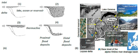
Figure 1.
Drawings (A) and pictures (B) illustrating the types of flows occurring during a flood event, based on the density difference between the tributary and the receiving basin: hypopycnal (1), homopycnal (2), mesopycnal (3), and hyperpycnal (4). Illustrations in (B) from the western Alps (white star) drainage basin of the Alpine Rhone River (Switzerland/France) show how sediments eroded by glaciers (5) can be transported by fine-grained suspended sediment load in fluvioglacial streams (6), resulting in homopycnal flows (2) and turbid waters in mountain lakes and reservoirs, mesopycnal (3) or hyperpycnal flows (4), and associated sediment plumes in the downstream lacustrine deltas. In mountain ranges, snowmelt and heavy rainfall can also cause erosive flash floods and large sediment plumes (2, 3, 4, and 6) in lakes. The alpine base level of the Rhone River in the southern Jura anticline is indicated by a blue circle. The IGN aerial photograph of a sediment plume in Lake Bourget, originating from the Leysse delta and illustrated in (B), is located in the southern part of the lake. The IGN aerial photograph of the Genissiat reservoir is from Geoportal (URL www.geoportail.gouv.fr, accessed on 11 February 2025).
Quaternary glaciations in mountain ranges resulted in the formation of numerous small glacial lakes at variable altitudes [7,11,12,13,14,15,16,17,18] and large glacial valleys now characterized worldwide by deep lakes, fjords, or thick Quaternary deposits of glacial, lacustrine, or fluvial origin [9,19,20,21,22,23,24,25,26,27,28,29,30]. In western Europe, Holocene climate change in the Jura mountains and the Alps (Figure 2) impacted erosion rates and favored sediment waves in alpine drainage basins, modulating river geomorphology (e.g., progressive downstream development of braided river patterns) and piedmont lake sedimentation (higher lake levels; more frequent and thicker flood deposits) during wetter periods characterized by strong westerlies over the Atlantic Ocean [31,32,33,34,35].
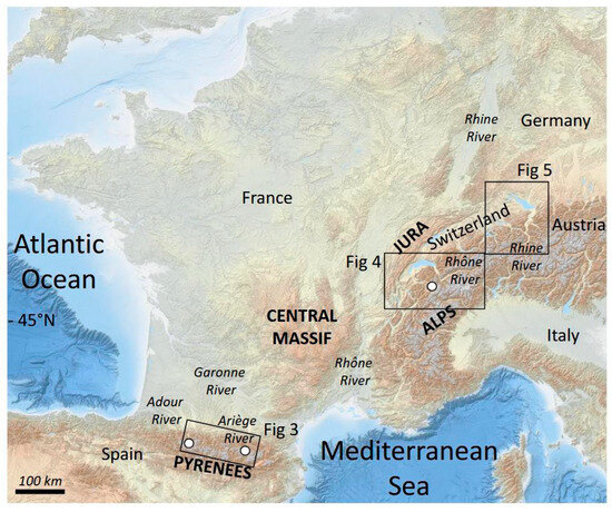
Figure 2.
General location of the study areas in the northern Pyrenees and the western and northern Alps, within the watersheds of the Garonne, Rhone, and Rhine Rivers. The small mountain glacial lakes investigated (white circles) and the large perialpine glacial lakes Bourget, Geneva, and Constance have been exposed to a wide range of natural hazards since the last deglaciation.
The population and infrastructure are also exposed to potentially catastrophic geological events at tectonic plate boundaries, along active faults and within mountain ranges. Short historical records, and even shorter instrumental records of extreme natural hazards worldwide, have shown that strong earthquakes, for example, can be accompanied by regional landslides impacting hydro systems, tsunamis (in both oceans and lakes), outburst floods, and even volcanic eruptions [19,36,37,38,39,40,41,42,43]. Considering the high vulnerability of lake shores and glacial valleys due to high population density and associated infrastructure, meticulous studies are needed to assess geological hazards in a changing world.
There are many attractive European glacial lakes in Scandinavia, the Alps, and the Pyrenees because they vary in terms of their altitude, size, depth, tributaries, and drainage basins. Previous studies have shown that these mountain regions have been subjected to a wide range of natural hazards since the last deglaciation: erosive snow avalanches [10,12,14,44,45], large rockfalls [24,29,30,46,47,48,49], strong earthquakes [7,13,16,50,51], lake tsunamis [29,48,52], and standing oscillatory waves (i.e., seiche waves; see [43,53,54]).
In this study, we review and document how sedimentary records in Pyrenean and Alpine lakes are sensitive environmental archives of cascading natural hazards. Based on a similar multidisciplinary approach developed in (small and large) Alpine lakes and hydroelectric Pyrenean reservoirs over the last decades (Supplementary Figure S1), we apply a multi-hazard approach and discuss historical and prehistorical regional event stratigraphy associated with large (and sometime catastrophic) floods, earthquakes, and/or rockfalls in drainage basins and lakes exposed to rapid environmental changes following the last deglaciation, the neoglacial period (including the Little Ice Age (LIA)), and the Anthropocene. The aim of this study is to further illustrate and explain how environmental changes in mid-latitude mountain ranges are conditioning the sensitivity and instability of glacial lakes and their sediments not only to earthquake hazards but also to cascading natural hazards resulting from landslides, flooding, or snow avalanches.
2. Materials and Methods
2.1. Study Areas
In the European Alps, pioneering deep geophysical investigations of the largest perialpine lakes in France, Switzerland, Germany, Austria, and Italy [55] and several key site studies (such as Lake Bourget, France) with a dense grid of seismic reflection data within the lake basin allowed us to establish the detailed seismic stratigraphy of glacial lakes following the last deglaciation [56]. These acoustic data were calibrated only by long lake drilling in Zurich (Switzerland) and Annecy (France), providing a conceptual model of radiocarbon-dated sedimentological and geomorphological reconstructions resulting from glacial to interglacial environmental changes [57]. In the meantime, sub-bottom profiling using high-resolution seismic sources (3.5 kHz pinger and later modulating chirp sources) was similarly calibrated using gravity or piston cores in either large piedmont lakes [36,53,58] or small mountain lakes across the Alps to document environmental changes and Holocene natural hazards [7,11,13,15,48,50,51].
However, across the Pyrenees, the available reconstructions of paleoclimate conditions and environmental changes from the last climatic cycle are solely based on glacial geomorphology and geochronology, or on multiproxy studies of sediment cores from lakes and paleolakes [59,60]. Until now, the combination of high-resolution seismic mapping and multiproxy analysis of sediment cores has only been carried out in a glacial lake flooded by a hydroelectric dam in the Ariège Massif (Figure 2) to document mid-Holocene sedimentation changes associated with climate variability and human activities [14].
2.1.1. Northern Pyrenees
As shown in Figure 2 and Figure 3, the northern Pyrenees are characterized by several main glacial valleys draining the Ariège, Garonne, and Adour Rivers towards the Atlantic Ocean. Today, only a few cirque glaciers, small glacial lakes, and moraines from the late glacial to the early and late Holocene have been documented and dated at the heads of these drainage basins [17,18,61,62]. At the edge of the piedmont, large and thick paleolake sedimentary infills within these flat fluvio-glacial valleys have also been documented based on gravity data [23,63].
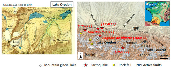
Figure 3.
Location of Pyrenean mountain lakes Orédon and Fourcat within the Garonne and Ariège Rivers’ drainage basins. The North Pyrenean Fault (NPF) and other active faults (dotted lines), together with the years of historical earthquakes and their likely epicenters (red stars) and large rockfalls (yellow circles), are indicated according to [49]. The extension of the 21 June 1660 CE Bagnère-de-Bigorre earthquake intensity is also illustrated in roman numbers (right panel) were red area (intensity VII), orange area (intensity VI), yellow area (intensity V) and green area (intensity IV) are indicated. As shown on the old topographic map (left panel), Lake Orédon drained several glaciers and glacial lakes during the Little Ice Age. These natural lakes were later flooded by hydroelectric dams, as detailed in the text.
This part of the Pyrenees is characterized by moderate seismic activity, although several strong historical earthquakes have clustered next to the North Pyrenean Fault (NPF), which illustrates that this major thrust fault system and other connected faults are active [49,64,65]. One of the most destructive Pyrenean earthquakes occurred in the Central Pyrenees, on 21 June 1660 CE (Figure 3), with an epicentral intensity of VIII–IX on the MSK scale (1964), near Bagnère-de-Bigorre, and its magnitude is estimated to be equivalent to Mw 6.1. Several large landslides and rockfalls have also been identified in the Central Pyrenees (Figure 3). According to [49], the age of a large and deep-seated landslide points to a single event back in 580 CE (the Lavedan earthquake, poorly documented by the bishop and historian Grégoire de Tours [66]). Undated large rockfalls in the Troumouse cirque suggest geological control combined with ice wastage and the migration of headwall weathering zones [62,67]. Between these two sites, the undated Coumely rockfall, a touristic site on the road towards the UNESCO-listed Gavarnie and Troumouse cirques, could also have resulted from the 580 CE Lavedan earthquake [68].
Lake Orédon (46 hectares (ha) and 1 km long) is one of the largest glacial lakes (together with Lake Cap de Long) in Pyrenees National Park in the Néouvielle massif. It drains into the Neste d’Aure River, a tributary of the Garonne River (Figure 3). Old topographic maps and pioneer studies from this region highlighted the occurrence of several glaciers in the upper catchment area, culminating at an altitude of 3194 m at the end of the Little Ice Age (LIA) [66]. Up to three high mountain streams draining two lakes and contrasted geological formations (granites and sedimentary rocks) build a delta in the SW part of Lake Orédon [69]. This lake was 35 m deep [70] before the construction of a dam in 1880 CE, which increased its depth to 59 m, when the first bathymetric map was produced [71]. Since then, the lake level has fluctuated (+/− 24 m) above a minimum altitude of 1832 m above sea level (asl) to produce hydroelectricity. Since the mid-19th century, the first temporary dams have been used to facilitate wood transport during summers from the lake shore to the town of St Lary located downstream of the Neste d’Aure River at 830 m asl [72]. Successive dams have been built downstream of Lake Cap de Long since 1909. In 1953, the largest hydroelectric reservoir in the northern Pyrenees completely flooded the lakes of Cap de Long and Loustallate, visible in Figure 3. A road was built upstream from Lake Orédon to reach Lake Cap de Long. Galleries were also drilled toward the west (into the Adour River drainage basin; Figure 2) to export water and produce hydroelectricity using a penstock [72]. In 1971, additional galleries were constructed to connect the Aumar and Aubert hydroelectric reservoirs (previously glacial lakes that drained into the NE part of Orédon) to increase the storage capacity of the Cap de Long reservoir [73]. Since this period, the Cap de Long hydroelectric infrastructure has been modulated according to water storage capacities and agriculture needs within the Garonne River watershed. However, globally, it has drastically reduced the water and sediment supply to the Orédon reservoir [74]. The first gravity cores retrieved from Lake Orédon were dated (by radionuclides and radiocarbon) and analyzed to document the evolution of atmospheric pollution since the Late Holocene [73].
Lake Fourcat is a small (24 ha, 500 m long), 63 m deep glacial lake located in the Vicdessos valley in the Ariège massif (Figure 3) at 2412 m asl. Since 1917, when a small dam was built, it has provided water and energy for the aluminum industry at Auzat (740 m asl). It has a small tributary delta draining the Fourcat glacial cirque, culminating at 2859 m asl (forming a natural border between France and Spain), and Lake Oussade (2.9 ha, unknown water depth), located at 2495 m asl. According to the 10Be age of a roche moutonnée damming the upper Picot Lake located at 2424 m asl in the Picot cirque, just next to the Fourcat cirque [17], it is likely that Lake Fourcat was formed around 8.4 +/− 0.2 thousand years ago (kyr).
2.1.2. Western Alps
The western Alpine range (in France, Switzerland, and Italy), together with the Molasse Basin and the Jura Mountains (Figure 4), was covered by ice during the last glaciation. Following deglaciation, thick lacustrine and deltaic sequences were deposited in numerous over-deepened lake basins draining multiple cirque glaciers in the Alpine glacial valleys, where the Rhone, the Arve, and the Isère Rivers now flow, forming fluvio-glacial and alluvial plains [75]. All these flat French and Swiss Alpine valleys reflect the development of very large paleolakes, as documented by drilling and seismic reflection profiles on land [28,76]. This part of the Alps is also characterized by the large perialpine lakes Geneva, Annecy, Bourget, Aiguebelette, and Paladru (Figure 4).
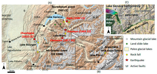
Figure 4.
Geological setting of the western Alpine glacial lakes and main cities (square black boxes) within the Rhone River drainage basin (A). Location of Lake Blanc in the Aiguilles Rouges Massif (B). Quaternary sediment infill in the Rhone valley and multibeam bathymetry of Lake Geneva (URL www.swisstopo.ch, accessed on 19 May 2025) reflect several paleolakes (black arrows) in (C), where the black dotted lines indicate sediment infill more than 700 m thick according to [26] and the purple color in Lake Geneva illustrate its bathymetry below 300 m. Lake Geneva crosses the Sub-Alpine Molasse Front (SAMF) in the Tertiary Molasse basin (between the Jura and the Alpine foreland) and partly the Sub-Alpine (frontal thrust) Fault (SAF). Lake Bourget formed at the contact between the SAF and the first Jura folds, developing a large plateau towards the north between the Jura (frontal thrust) Fault (JF) and the Molasse Basin. The Culoz fault (CF) and Vuache fault (VF) are documented strike-slip active faults. Strong Swiss and French historical earthquakes and rockfalls recorded in these lakes are located and discussed in the text. The location of the mountain lakes Bramant (BRA), Blanc Huez (LBH), Lauvitel (LL1), and Laffrey (LL2) is also discussed in the text.
The well-known Lake Geneva (582 km2, 72.8 km long and 309.7 m deep), the largest European lake, is located at 372 m asl at the French and Swiss border, between the Jura and Subalpine massifs. Its central deepest basin occurs just at the subalpine frontal thrust front and constitutes a sediment sink for the (Swiss) Rhone (ca. 5220 km2) and (French) Dranse (ca. 495 km2) Rivers’ catchment areas. Lake Geneva is a large proglacial lake, draining several large Swiss glaciers including the Aletsch (128 km2) and the Rhone (17 km2) glaciers via the Rhone delta. In the city of Geneva, the outflowing waters of Lake Geneva quickly mix with the confluence of the Arve River (Figure 1), draining up to 2074 km2, including the Aiguilles Rouges and the French part of the partly glaciated Mont Blanc Alpine massifs [33]. Lake Blanc (2 ha) is one of the small glacial lakes in the Aiguilles Rouges Massif (Figure 4). This proglacial lake is 10 m deep and lies at 2352 m asl at the foot of a ca. 1 km2 cirque where the Belvédère Glacier has developed glacial deposits [13]. Lake Bourget (44.5 km2, 19 km long and 145 m deep) is the largest natural lake in France. It is located at 231 m asl in the southern-most syncline of the Jura mountains, between two anticlines, at the foot of the subalpine frontal thrust front (Figure 4). This fjord lake has been draining since ca. 10,000 years into the Rhone River, and it has two permanent tributaries draining the surrounding subalpine massifs slopes: the Leysse (306 km2) and the Sierroz (157 km2) Rivers [34]. However, prior to this period, the Rhone River had not yet filled the northern part of the postglacial lake and was its main tributary [31,75]. Since then, only large Holocene Rhone River floods have overflowed the Chautagne Swamp and entered Lake Bourget, increasing its lake level and its drainage basin up to ca. 4000 km2, as illustrated in Figure 1 and further detailed in [31,33,34]. Lakes Bourget and Annecy are also closely connected to NW-SE active strike-slip faults (the Culoz and Vuache faults, respectively), and the area is characterized by moderate seismicity. One of the strongest regional earthquakes occurred on 18 February 1822 at the Culoz fault below the Chautagne swamp, just north of Lake Bourget, with an epicentral intensity of VII–VIII on the MSK scale (1964), and its magnitude is estimated to be equivalent to Mw 5.5–6.0 [43,54]. This Chautagne event triggered multiple coeval subaquatic landslides and a seiche deposit in the deep central basin of Lake Bourget. The Aigle (1584 CE, Mw 5.9), Chamonix (1817 CE, Mw 4.8), and Emosson (1905 CE, Mw 5.5) earthquakes (Figure 3) were also regional events [13]. In addition, this part of the Alps has been exposed to well-documented historical catastrophic rockfall events and their consequences: the tsunamigenic Tauredunum major event (563 CE) near Lake Geneva [48,77]; the ca. 24 km2 and 5100 m3 Mont Granier event (1248 CE) [78]; the artificial Casquette event across the railway in 1973 at the shore of Lake Bourget [75]; and the ongoing Late Holocene Argentière rock slope failure in the Aiguilles Rouges massif, which constitute a future major risk for the upper Arve valley and Chamonix city [79]. Finally, two rockfalls evolving into landslides in the Dranse River drainage basin formed Lake Montriond ca. 500 years ago and Lake Vallon in March 1943 [80].
2.1.3. Northern Alps
The northern Alpine ranges at the crossroads of Switzerland, Germany, Austria, and Liechtenstein (Figure 5) were also covered by ice during the last glaciation, and large alpine glacial lobes reached the Molasse Basin. Following deglaciation, large perialpine lakes formed in over-deepened basins at the piedmont (Lakes Zurich and Constance) and within glacial valleys (Lakes Lucerne and Walen). Large and thick paleolake deposits developing flat valleys are also documented at the edges of these lakes, especially in the Rhine River valley upstream from Lake Constance [28]. The source of the Rhine is in the Alps at 2341 m asl, and this river is the main tributary of Lake Constance (536 km2, 63 km long and 251 m deep) at 395 m asl. This well-documented proglacial lake is the third largest in Europe and has a drainage basin of 11,500 km2 at the border of Switzerland, Germany, and Austria.
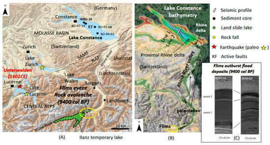
Figure 5.
Geological setting of the northern and central perialpine glacial lakes and main cities (Black square boxes) within the Rhine River drainage basin illustrating the schematic location of the Flims landslide deposit and the induced Ilanz temporary lake (A). Quaternary sediment infill in the Rhine valley and multibeam bathymetry of Lake Constance (URL from www.swisstopo.ch, accessed on 19 May 2025) reflect several paleolakes (black arrows), where the black dotted lines indicate sediment infill exceeding 700 m in thickness, according to [26] (B). The published 3.5 kHz seismic profiles (Lines 1 and 2), and the location of published long sediment cores from the deep central basin (black dots) used in this study, are located on the bathymetric map of Lake Constance, where the 100 m isobath marks the limit between the green- and blue-colored slopes. Pictures of the Flims outburst flood deposits in Lake Constance (C), discussed in the text, are from [10,30]. The well-documented Rhine delta of Lake Constance lies north of the Sub-Alpine Molasse Front (SAMF) and the Northern Alpine Front (NAF).
On 18 September 1601 CE, Central Switzerland was hit by the Unterwalden earthquake, one of the largest historical earthquakes in Central Europe (Mw = 6.2). This event, located at the North Alpine front, triggered multiple subaquatic slides, rockfalls, and tsunami waves, resulting in well-documented seiche waves in Lake Lucerne [36,52,53,81,82]. The Rhine valley was also hit around 9400 Cal BP by the largest rockslide (ca.12 km3) in the Alps and in Europe: the Flims event. This evolved downslope into a rock avalanche deposit that formed a temporary dam across the Rhine valley (the Ilanz lake, Figure 5) and outstanding outburst Rhine River flood deposits in the deep basin of Lake Constance [10,46,83,84,85,86,87].
2.2. Methods
A similar limnogeological approach combining acoustic mapping and multi-proxy studies of sediment cores was developed for the glacial lakes Fourcat, Orédon, Blanc, Bourget, Geneva, and Constance, as detailed in Supplementary Table S1.
The Pyrenean lakes Fourcat and Orédon were mapped, as shown in Figure 6, with the portable Knudsen pinger sub-bottom profiler. This device combines a high-frequency (200 kHz) transducer for mapping the bathymetry and a low-frequency (4 kHz) chirp source with a broadband hydrophone receive array for imaging the basin fill geometry in high resolution. The system is connected to a digital acquisition unit plugged to a laptop computer and a GPS onboard an inflatable boat. These data were calibrated in the field using an IKATEC gravity core. In the laboratory, the cores ORE-15A and FR14-A were stored in a cold room (4 °C) in Toulouse, split in two halves, and carefully described based on visual inspection and measurements of sediment stratigraphy (X-ray radiography) and geochemistry using the X-ray florescence (XRF) core scanner (ITRAX, Cox Analytical Systems: Mölndal, Sweden) in a U-channel at CEREGE (Aix en Provence). This scanning operation used a molybdenum target tube set to 30 kV and 25 mA. Acquisition of continuous XRF was performed at a 2 mm scale with an exposure time of 15 s. This method measures changes in the abundance of elements (K, Zr, Si, Ca, Ti, Mn, Fe, Cu, Zn, Br, Rb, Sr) along the sedimentary sequence. The XRF signal incoherence/coherence (Inc/Coh) is known to be a good proxy for organic matter in lake sediments [12]. In the Fourcat and Orédon cores, the organic matter was also quantified using discrete sediment sampling, and the content was measured and characterized by Rock-Eval pyrolysis at ISTO (Orléans), following the methods described in [6,7,14]. Recent sedimentation rates in these cores were determined based on 210Pb, 137Cs, and 241Am vertical profiles (Supplementary Tables S2 and S3) acquired using low background HPGe gamma spectrometers placed under 85 m of rock at the LAFARA underground laboratory [88]. Three AMS radiocarbon ages from organic macro remains were determined at Beta Analytics Radiocarbon Laboratory (Miami, FL, USA) and were used to establish the chronology of core ORE-15A (Supplementary Table S4).
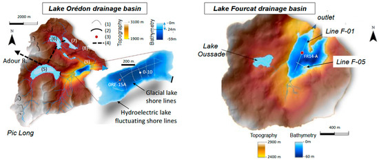
Figure 6.
Geomorphological setting, bathymetry, seismic grid, and coring sites of the Pyrenean lakes Orédon and Fourcat. (1) Little Ice Age moraines, (2) hydroelectric dam, (3) sediment core, (4) penstock, (5) Lake Cap de Long, (6) Lake Aubert, (7) Lake Aumar, (8) Lake Laquette, and (9) Lake Orédon.
Alpine Lake Blanc was similarly mapped with the portable Inomar parametric sub-bottom profiler. The transducer was used with an 8 kHz chirp signal, connected to an acquisition unit, a GPS, and a laptop computer, as shown in Figure 1. These data were interpreted and used to optimize the coordinates of a coring site. An UWITEC gravity corer and a piston corer (both 63 mm diameter) were used from the frozen surface of the lake during the winter of 2009–2010. One gravity core (BAR09P1) and two piston cores (BAR10-I and BAR10-II) were collected. A 250 cm long synthetic log was built for core BAR10-II based on sedimentary facies together with laser grain size, GEOTEK core logger measurements (magnetic susceptibility, gamma density, P waves velocity, video capture, and spectrophotometry), and Avaatech XRF core scanning, as detailed in [13]. Up to nine AMS radiocarbon ages from macro-remains were obtained at the LMC14 laboratory (Saclay, France), together with 137Cs underground measurements at the LGGE (Grenoble, France), in order to establish BAR10-II chronology. In addition, sedimentological and seismic data were used to identify rapidly deposited layers (RDLs) and to establish a composite sediment age–depth model. This chronology allows for correlating four different RDLs with local and regional historical events (see below).
As summarized in Supplementary Table S1, Lake Bourget sedimentary infill was intensively investigated by a wide range of single-channel seismic profiles with variable resolutions between 1977 and 2015 [15,31,33,56,75,76,89,90], a side scan sonar survey in 1992 [54,75,90], and two complementary multibeam bathymetry surveys in 2008 and 2020 [15,43,91]. In 2015, the Knudsen pinger sub-bottom profiler was used with its 4 kHz chirp source to map the deepest central basin in order to compare the performance and seismic facies of different high-resolution devices (see below). Following the pioneer air gun seismic profile of Lake Bourget [55,76] (Supplementary Figure S2), a 7.5 m long piston core was retrieved in 1977 with the ETH Kullenberg corer in the deep central basin. Pictures of core LDB1977 were never published, but are archived at ETH Limnolab and are used in this study based on grayscale profiles of the sedimentary facies extracted from the digitalization of the original argentic pictures (see below). Up to 67 gravity cores were studied (38 retrieved with F.A. Forel Institute Benthos corer in 1997 [75] and 29 with the UWITEC corer from 2001 to 2017 [43,92]) from all the different sedimentary environments identified in Lake Bourget. Two of these gravity cores from the deep central basin (one Benthos core and one UWITEC core) were dated with radionuclides (210Pb and 137Cs) at LGGE, allowing the establishment of key chrono-stratigraphic markers related to the lake eutrophication (1940 CE), the 1822 CE earthquake triggered deposits, and the oldest-known historical flood deposit of the Rhone entering Lake Bourget (1732 CE) [54,75,92]. Long piston cores LDB01-1, LDB01-2, and LDB04 were taken in 2001, 2002, and 2004, respectively, within the depocenters of the Holocene Rhone River flood deposits visible on sub-bottom profiles [10,15,31,33,34,37,92] and dated by AMS radiocarbon [31,33,34] at the Poznan and Saclay laboratories (Supplementary Table S1). They were characterized by sedimentary facies, laser grain size, GEOTEK core logging (at ETH Zurich, Switzerland), and Avaatech XRF core scanning, as detailed in [31,33,34].
Figure 7, Supplementary Figure S2, and Supplementary Table S1 illustrate the compilation of vintage and new seismic data from the central basin of Lake Geneva used in this study: (i) analog air gun profiles L1 to L3 collected in 1969 (Figure 7A, [93]); (ii) analog air gun profiles collected close to profile L3 between the cities of Evian and Lausanne [55]; (iii) digital single-channel 500 J CENTIPEDE sparker (RCMG, Ghent, Belgium) data collected in 1996 and 1998, onboard R/V La Licorne, from Institut F.A. Forel and Geneva University (Figure 7B, [75]); (iv) the isopak map of lacustrine deposits (Figure 7A) from [94] based on EPFL digital multichannel air gun seismic surveys between 2000 and 2004; and (v) new digital sub-bottom profiles (Figure 7A) collected from surveys in June 2023 (Knudsen pinger 4 kHz chirp and EXAIL Echoes 10,000 compact (10 kHz chirp)) onboard transportable EXAIL (La Ciotat) R/V GGXIII and October 2023 (Knudsen pinger 4 kHz chirp) onboard INRAE (Thonon–les–Bains) R/V Daphnie. Six long piston cores were retrieved from this deep basin (Figure 7A) using the ETH Kullenberg corer in 1990 (cores J-34 and J-35, [95]) and in 2010 (cores Ku-I, Ku-II, Ku-IV, and Ku-V, [48,96]). The sedimentary sequence of core Ku-IV has been merged with the nearby UWITEC gravity core KK8 to create a composite record dated by radiocarbon [48,96], radionuclides (137Cs, 210Pb) [97], and paleomagnetism [98]. As shown in Figure 7, sedimentary facies, radionuclide, and radiocarbon data from cores J-34, together with Ku-I, Ku-II, and Ku-V, were used to calibrate the sub-bottom profile collected in 2023. These new sub-bottom data were also collected close to previously available seismic data (Figure 7A) and based on the 3.5 kHz pinger dataset from [41,96].
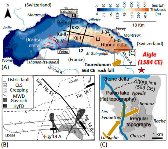
Figure 7.
Compilation of available geophysical and coring data from Lake Geneva’s central basin. (A) Isopack map (in millisecond (ms) two-way travel time (twt) and meters)—modified from [96]—of lacustrine sediments illustrating Dranse and Rhone deltaic depocenters from multichannel air gun seismic surveys (light gray lines), locating Swiss and French littoral towns; former coring sites (J-34, J-35 Ku-I, Ku-II, Ku-IV, Ku-V, and KK8). Single-channel air gun seismic lines from 1969 (black thick lines L1, L2, and L3), together with 4 kHz chirp lines from September 2023 (red lines) and chirp lines (4 kHz and 10 kHz) from June 2023 (red dotted lines), are illustrated in this study. The epicenter of the Aigle earthquake and the impact zone of the Tauredunum rockfall in the Swiss Rhone valley are located. (B) Sparker seismic surveys from 1996 (black dotted lines) and 1998 (black lines) mapping Dranse delta sedimentary environments (from [75]), illustrating gas-rich deposits exposed to gravity and flooding hazards: channel–levee system (CLS); hyperpycnal flood deposit (HyFD); mass wasting deposit (MWD). The location of the sparker profile interpretation illustrated in Supplementary Figure S5 is indicated by a bold black line. (C) Irregular topography of Rhone valley related to Tauredunum rockfall deposits at the edge of the lake shore line, according to [77].
Lake Constance’s main basin was also previously mapped using a wide range of acoustic data. This includes analog air gun [55]; analog 3.5 kHz pinger and side scan sonar [99,100]; and multibeam bathymetry, digital 3.5 kHz pinger, and digital multichannel air gun seismic profiles [85,87] calibrated by radiocarbon-dated Kullenberg and UWITEC piston coring in 1991, 1994, 1997, and 2019 [84,85,87], as illustrated in Figure 5 and Supplementary Table S1.
3. Results
3.1. Lake Fourcat Seismic Stratigraphy
Lake Fourcat bathymetry, based on seismic data, is up to 36 m deep (applying a mean P wave velocity of 1.45 km/s in fresh water) in its western sub-basin (Figure 6 and Figure 8), but 60 m locally in the eastern basin [101]. The western basin is fed by a small tributary delta. On seismic profiles, the bedrock is clearly visible. It outcrops above ca. 21 m water depth (34 ms twt) along the western and eastern basin slopes (and at all the granitic shore lines) and towards the outlet. In front of the delta, a transparent unit (TU, Figure 8) is up to 4 ms twt thick and pinches out laterally along the steep bedrock slopes and toward the outlet. Assuming a mean Pw velocity of 1.5 km/s in lacustrine sediments, the TU is up to 3 m thick. At the FR-14A coring site, the TU is, however, only 2 ms twt thick (i.e., around 1.5 m).
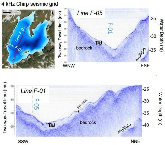
Figure 8.
Lake Fourcat seismic stratigraphy illustrating the acoustic facies of the bedrock below a transparent unit (TU) and the location of gravity core FR-14A.
3.2. Lake Orédon Seismic Stratigraphy
During the seismic survey in June 2015, Lake Orédon was low, and its bathymetry was only up to 38 m deep (Figure 9). Line 1 shows the paleo-delta of the natural glacial lake flooded by the hydroelectric reservoir, which is clearly visible on the SW lake floor. Below 30 m water depth (ca. 40 ms twt), the penetration of the chirp signal improves toward the central basin, and the bedrock is locally visible down to 66 ms twt along the basin axis. The bedrock outcrops along the western and eastern basin slopes above 52 ms twt (ca. 38 m water depth) and along the reservoir shorelines. On the lake floor, the sedimentary infill of Lake Orédon is composed of three seismic units. A chaotic to transparent basal unit (CU) between 66 and 61 ms twt is identified in the deepest part of the central basin. Above it, a transparent unit (TU) is identified in the deepest axial part of the basin (from 61 to 59 ms twt), pinching out at the steep western and eastern slopes and toward the outlet around 58 ms twt. The upper unit (SU) is characterized by stratified acoustic facies consisting of continuous high-amplitude and high-frequency reflections. This unit has a divergent geometry reaching up to 6 ms twt (ca. 4.5 m) toward the SW in the direction of the delta slopes and thinning toward the NE in the direction of the lake outlet. In this sector, the reflections become wavy and are interrupted locally (at depth and at the lake floor) by several lenses with chaotic to transparent facies. Thinner and smaller but similar lenses are also identified between the continuous and high-amplitude reflections of the basin depocenter at the edge of the delta slopes. The upper one was sampled by gravity core ORE-15A, and four others occurred at depth. Core O-10 was comparatively taken in the distal part of the basin, in a flat area where sediments are well stratified.
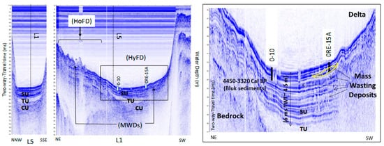
Figure 9.
Lake Orédon seismic stratigraphy illustrating the acoustic signatures of a chaotic unit (CU), a transparent unit (TU), and a stratified unit (SU) exposed to hyperpycnal flood deposits (HyFDs), homopycnal flood deposits (HoFDs), and mass-wasting deposits (MWDs). The locations of gravity cores O-10 and ORE-15A, discussed in the text, are also indicated. The upper MWD (yellow line) has been sampled in core ORE-15A.
3.3. Composition and Chronology of Lake Fourcat and Lake Orédon Sediments
Recent sediments in Lake Fourcat highlight two contrasting sedimentary facies in core FR-14A (Figure 10). The upper facies (0–4.5 cm depth) is characterized by laminated dense sediments in X-ray images and by high values of Fe and a low inc/coh ratio in XRF data. Based on Rock-Eval measurements, this upper unit contains ca. 2% of total organic carbon (TOC). The lower unit (4.5 to 21.5 cm depth) is also laminated in X-ray images, but is less dense, contrasting with frequent small drop stones, locally developing several horizons (ca. 7 cm, 13 cm, and 20 cm core depth). This unit consists of organic-rich sediments (6 to 7% TOC), a higher inc/coh ratio, and a lower XRF intensity of Fe. Rock-Eval pyrolysis results represented by an S2 (mgHC/g, S2 = HI × TOC) versus TOC (%) diagram fall within the same area below the line (IH = 300 mgHC·g−1·TOC). This characterizes the terrigenous organic matter typical of soils [6,7,14]. The maximum content of 137Cs was identified within the upper unit between 2 and 3 cm core depth (Supplementary Table S2), together with traces of 241Am detected between 1 and 2 cm core depth (Figure 10). These radionuclides can be associated with the nuclear weapon tests culminating in 1963 CE in the Northern Hemisphere [6,7,14]. A mean sedimentation rate of 0.05 cm/yr can therefore be estimated for the upper unit and allows dating the transition to the lower unit to 1924 +/− 20 CE (considering that 1 cm of sediment sample corresponds to 20 years of sedimentation). Assuming that Lake Fourcat was formed around 8.4 kyrs and that the P wave velocity of the lower unit is ca. 1.5 km/s, it is likely that the 145 cm thick sedimentary sequence visible in seismic data accumulated with a mean sedimentation rate of 0.017 cm/yr.
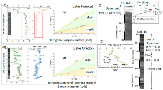
Figure 10.
Recent sedimentation in Lakes Fourcat and Orédon. The characterization of lake sediments in the transparent unit (TU) from Lake Fourcat and in a stratified unit (SU) from Lake Orédon is based on X-ray image, XRF, and Rock-Eval data of sediment cores FR-14A (A) and ORE-15 (B). Sediment chronology in Lake Fourcat based on radionuclide (C) and both radionuclide and radiocarbon dating in Lake Orédon (D) detailed in Supplementary Tables S2–S4. Sediment samples with detected content in 241Am are indicated by a red arrow in Lake Fourcat and by black arrows in Lake Orédon as discussed in the text.
Recent sediments from Lake Orédon’s core ORE-15 are essentially laminated in X-ray images, and two different sedimentary facies can be detected (Figure 10). Between 0 and 33 cm core depth, the sediments are characterized in X-ray images by a succession of horizontal laminae with variable thicknesses and densities. From 33 cm to the base of the core (93 cm core depth), the sediments consist of an alternation of laminated deposits (between 35–43 and 48–55 cm core depth) and massif deposits (at 45–47 and 55–65 cm core depth). There are also layers made of discontinuous, tilted, or folded laminae (at 47–55 and 65–93 cm core depth). Drop stones are also detected in X-ray images around 25 cm and between 65 and 68 cm core depth. Due to the high water content and irregular sediment surface on the U-channel, it has not been possible to measure sediment XRF intensities correctly between 11 and 27 cm core depth (Figure 10). However, it is possible to distinguish the upper 33 cm of the sediment core from the lower part. The upper unit is characterized by Ti XRF intensity oscillating around 2000 and a fluctuating yet decreasing trend in TOC from 3 to 1 % between 33 cm core depth and the top of the core. The lower unit highlights more variable values of both the inc/coh ratio and Ti (between 1000 and 3000). On the S2 (mgHC/g, S2 = HI × TOC) versus TOC (%) diagram, the Rock-Eval pyrolysis measurements of all the sediment samples from Lake Orédon also fall within the same area and below the line (IH = 300 mgHC·g−1·TOC) characterizing organic matter of pedologic origin [6,7,14]. The maximum 137Cs content in the sediment is clearly identified within the upper unit between 9.5 and 10 cm core depth (Supplementary Table S3), together with traces of 241Am (Figure 10). These signatures at a core depth of 9.5 cm can be associated with the nuclear weapon tests culminating in 1963 CE in the Northern Hemisphere [6,7,14]. A mean sedimentation rate of 0.18 cm/yr can be estimated for the upper 9.5 cm of core ORE-15.
Three samples of organic macro-remains from core ORE-15 at 18.5, 25, and 45 cm core depth (Figure 10) were dated by AMS radiocarbon at Beta Analytic Radiocarbon Dating Laboratory (Miami, FL, USA), further constraining the core’s chronology (Supplementary Table S4). However, the two samples from the upper unit are not in chronological order, suggesting that the organic material sampled at 18.5 cm core depth (dated to 1677 +/− 17 Cal CE) was reworked from the Lake Orédon drainage basin. A mean sedimentation rate of ca. 0.06 cm/yr can thus be estimated for the upper unit between the main 137Cs peak at 9.5 cm (1963 CE) and the radiocarbon sample at 25 cm (1725 +/− 55 cal CE). This allows dating the transition to the lower unit at 1592 +/− 55 cal CE (Figure 10).
The association of sedimentary facies of the lower unit and the identification of chaotic acoustic facies near the lake floor at the sub-surface of the ORE-15A coring site are the typical signatures of mass-wasting deposits in lakes [19,33,36,41]. The age of 950 +/− 53 cal CE at 45 cm core depth in ORE-15 suggests that a historical mass-wasting event reworked sediments that had initially accumulated at the delta slope during the last millennium.
The 210Pb and 137Cs data from core O-10 indicate flooding of Lake Orédon in 1892 CE at 20 cm core depth [73]. This indicates a mean sedimentation rate of 0.18 cm/yr, similar to that estimated for ORE-14 from 137Cs data. Core O-10 bulk sediment radiocarbon dating at 105 cm core depth (3890 +/− 560 cal BP, [73], Figure 9) allows for a rough estimate of a mean sedimentation rate of 0.02 cm/yr during the Late Holocene and further documents the low sedimentation rates in northern Pyrenean mountain lakes during the Holocene, compared to alpine lakes [6,14].
3.4. Lake Blanc Seismic Stratigraphy and Event Stratigraphy
The seismic stratigraphy of proglacial Lake Blanc illustrates three seismic units on most of the Inomar 8 kHz sub-bottom profiles acquired with a dense grid (Figure 11A). A chaotic unit (CU) is identified locally above the acoustic substratum formed by the bedrock outcrops along the southern lake shoreline (gneiss rocks). A transparent unit (TU) is documented above the CU in the deepest part of the glacial basin. The majority of the sedimentary infill of Lake Blanc is associated with a stratified unit (SU), which consists of continuous reflections deposited at a high frequency. The density of seismic profiles in this small lake allows for the production of isopack maps for the TU and SU (Figure 11B). Both seismic units have a divergent geometry: they thicken toward the delta and thin toward the outlet. The TU reaches 3 ms twt in thickness corresponding to ca. 3 m of sediments (using a Pw of 2000 m/s in the sediments as measured on BAR10 sediments [13]), while the SU is slightly more than 8 ms twt (ca. 8 m) thick in the deep central basin near the BAR10 coring site. Two mass-wasting deposits are also identified as transparent to chaotic lens-shaped bodies at the foot of the delta near the lake floor at 15 ms twt (ca. 2 m below the lake floor).
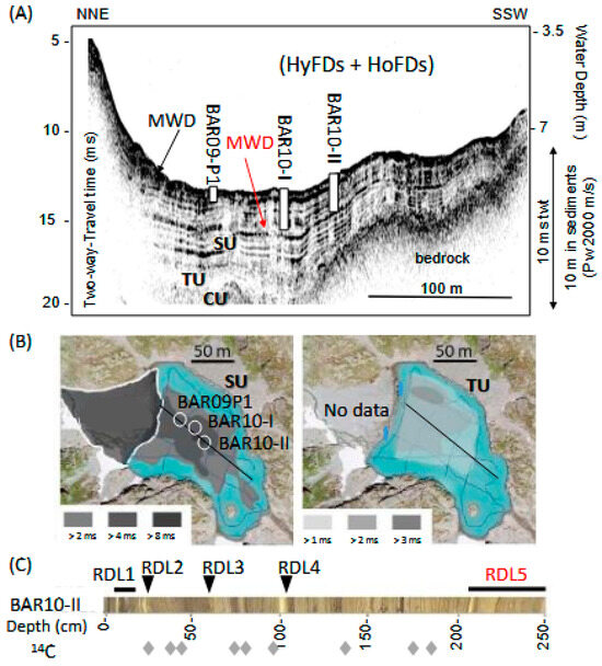
Figure 11.
Synthesis of Lake Blanc event stratigraphy. (A) Seismic stratigraphy illustrating the acoustic signatures of a chaotic unit (CU), a transparent unit (TU), and a stratified unit (SU) together with the location of cores BAR09P1, BAR10-I, and BAR10-II on the seismic line illustrating hyperpycnal flood deposits (HyFDs), homopycnal flood deposits (HoFDs), and mass-wasting deposits (MWDs). (B) Isopack maps of seismic units SU and TU also locating the BAR cores within the lake. (C) BAR10-II sedimentary facies with intercalated rapidly deposited layers (RDLs) and radiocarbon samples (gray diamonds).
The BAR10-I piston core is 280 cm long, and BAR 10-II is no longer than 250 cm, because these sediments were so compacted and dense that further penetration with the UWITEC corer was not possible. Thus, the base of the SU was not reached. The sediment mainly consists of finely laminated silty clay deposits interbedded with drop stones and frequent coarse-grained layers, which are interpreted as large flood-induced turbidites (i.e., hyperpycnal flood events [13]). Up to five rapidly deposited layers (RDLs) are also identified on core BAR10 II (Figure 11C). RDL1 is a mass-wasting deposit (slide) between 6 and 24 cm on the BAR09P1 gravity core. This slide thins laterally toward BAR 10-II and is capped by a thin turbidite layer ending with a light-colored clay cap on top of both piston cores used to build the composite sequence, as shown in [13]. This graded bed is interpreted as a slide-induced turbidite. 137Cs sediment content from BAR09P1 was only detected within RDL1 and above it, but not below it, suggesting that this slide resulted from the destabilization of recent sediments (i.e., post-1950 CE) accumulated on the subaquatic delta slopes [13]. RDL2, RDL3, and RDL4 are similarly slide-inducted turbidites ending with light-colored clay caps (Figure 11C). RDL5 is found near the base of BAR10-II (at 206 cm core depth) and consists of a 44 cm thick mass-wasting deposit made of tilted to folded lamina and massif deposits, which also end in a slide-induced turbidite and a clay cap. This event is visible on sub-bottom profiles (MWD2 in Figure 11A). It originates from the delta slopes and thins toward the BAR10-II coring site. The chronology of these cores, provided by radiocarbon samples, allows for establishing an age–depth model of the composite sedimentary sequence, excluding RDLs, as detailed in [13]. The previous study focused on the upper 190 cm of BAR10 II (i.e., the upper 85 cm of the composite sedimentary record) covering the last 1400 years (718 +/− 55 cal CE). This age–depth model detailed in [13] allows for correlating RDL1, RDL2, RDL3, and RDL4 with historical events (see the Discussion section). Unfortunately, the age of RDL5 is not clearly established, and bulk sediment radiocarbon dating is not suitable for this lake [13]. Extrapolating a mean sedimentation rate of 0.01 cm/yr, calculated between the two lowest radiocarbon dates (718 +/− 55 cal CE and 1020 +/− 120 cal CE) from the composite sedimentary record, suggests that it was possibly triggered 1600 years earlier (i.e., 880 cal BC or ca. 2800 cal BP). Thus, this important mass-wasting deposit in Lake Blanc was probably not contemporaneous with the 563 CE Tauredunum catastrophic rockfall event documented near the Rhone delta in Lake Geneva. However, RDL5 might be contemporaneous with the initiation of the nearby Argentière rock failure (Figure 4) estimated between 1.3 and 2.5 thousand years ago by 10Be dating [79].
3.5. Lake Bourget Event Stratigraphy
The detailed seismic stratigraphy of Lakes Bourget and Annecy (Figure 1 and Figure 4) resulting from the last climatic cycle has been previously established based on sparker data (Supplementary Table S1) and on the CLIMASILAC drill core calibration [56,57,58]. Together with lower-resolution air gun data from a previous study [55], these acoustic data highlight a deep and asymmetric glacial erosion surface (Supplementary Figure S2) and the development of a similar seismic stratigraphy in over-deepened sub-basins along axial profiles [76]. These basin fills are dominated by Late Glacial lacustrine deposits developing thick stratified units with divergent geometries near tributary deltas and migrating channel–levee systems, building deep lacustrine deltaic fans. High-resolution seismic data from Lake Bourget (Figure 12) clearly image the upper part of these Late Glacial lacustrine deposits, together with a catastrophic basin collapse event that occurred ca. 9400 cal BP. This event formed multiple mass-wasting deposits capped by a thick seiche deposit [15,33,56,75]. These basin collapse deposits, up to 20 m thick [75], are visible on vintage air gun data (Supplementary Figure S2). They are covered by a Holocene lacustrine drape up to 15 m thick. This Holocene drape is dominated by authigenic production in the lake water, but high-amplitude reflections in front of tributary deltas were also identified [10] and sampled by either gravity or piston corers.
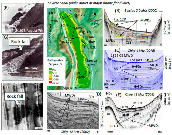
Figure 12.
Geomorphology and stratigraphy of Lake Bourget shore lines and sedimentary infill. (A) Topographic maps and bathymetry slope maps of Lake Bourget locating selected seismic profiles shown in (B–E) (black lines) and side scan sonar mosaic illustrating the 1973 rockfall deposit on the lake floor (white rectangle). (F) Picture of the ongoing Casquette rock fall event. (G) Picture of the Casquette Rock fall deposit on land. (H). Side scan sonar mosaic of the lake floor illustrating the Casquette rock fall deposit underwater. CS: Chautagne swamp. SC: slide scar. MWD: mass-wasting deposit. CLS: channel–levee system. HyFDs: hyperpycnal flood deposits. MFDs: mesopycnal flood deposits. SD: seiche deposit. FDs: flood deposits. HDs: hemipelagic deposits. m: moraine.
Figure 12 illustrates a wide range of morphologies and deposits in Lake Bourget resulting from both gravity and flooding hazards. High-amplitude and continuous reflections are intercalated within Holocene hemipelagic deposits in front of the lake outlet (exposed to Rhone River flooding events, Figure 12D) and in front of the Leysse and Sierroz deltas. Such reflections are also identified locally within the protected and shallower Grésine Bay (Figure 12E). These reflections are interpreted here as resulting from the influence of the Coriolis force, which deviates suspended sediment plumes produced by powerful mesopycnal Sierroz River flood events northward (toward the right). In the deep central basin, distal Sierroz River mesopycnal flood deposits similarly develop high-amplitude reflections only along the eastern slopes of the basin ([10], Figure 12C). Along the central axis of the deep basin, there are several well-developed high-amplitude reflections below and above the basin collapse deposits. These reflections are either Sierroz or Rhone rivers’ distal hyperpycnal flood deposits following the lake floor topography during the Late Glacial and the Holocene ([10] Figure 12C). Toward the northern basin, below the Holocene drape and successive small mass-wasting deposits, a channel–levee system can be clearly identified on seismic profiles. This system is associated with the development of powerful Late Glacial to early Holocene proximal Rhone River hyperpycnal flood events [31,33,34,56,75,89]. The two levees are dissymmetric (Figure 12B,D). The right-hand (western) side levee is higher and results from the exposure of the fine-grained turbulent hyperpycnal sediment plumes to the Coriolis force. Next to this channel–levee system, a well-stratified depocenter is identified along the northwestern slopes of Lake Bourget (Figure 12B,D) and interpreted as frequent Late Glacial to Early Holocene Rhone River mesopycnal flood deposits. This depocenter resulted from the influence of the Coriolis force on frequent fine-grained suspended sediment plumes trapped above the lake thermocline and deflected to the right [31]. The alimentation of these two contrasting depocenters of proximal Rhone River flood deposits ended once the Rhone River bypassed Lake Bourget ca. 10,000 years ago [101]. A similar Rhone River mesopycnal flood depocenter was identified in the deep central basin along the western slopes and below the basin collapse deposits (Figure 12C). These Late Glacial to Early Holocene distal Rhone River mesopycnal flood deposits were strongly impacted and remolded by the basin collapse event at 9400 cal BP [15,34,54,56,75].
Multiple slide scars and mass-wasting deposits (MWDs) along steep slopes (Figure 12A) are identified on multibeam bathymetry, side scan sonar [54], and sub-bottom profiles in proximal (Figure 12B,D) and distal deltaic deposits (Figure 12C). Late Glacial MWDs are also identified in Grésine Bay (Figure 12E). Recent and Holocene subaquatic MWDs produce typical chaotic morphologies on the lake floor and chaotic to transparent lens-shaped bodies on seismic profiles. In the deep central basin (Figure 12C), up to three seiche deposits are also highlighted on 4 kHz chirp profiles. They produce a typical transparent acoustic facies and a high-amplitude basal reflector, both of which are found in the deepest part of the lake basin. The 1822 CE seiche deposit is up to 23 cm thick at the LDB1977 coring site (Supplementary Figure S3) and laterally covers one of the earthquake-induced slides (Figure 12C) along the western slope of the deep central basin [15,41,52]. The 9400 cal BP seiche deposit is up to 2 km wide, covering the basin collapse deposits. It is up to 2 ms twt thick (ca. 150 cm), and this rapidly deposited layer is characterized by a very flat upper limit. Another seiche deposit, up to 1 ms twt thick (ca. 75 cm), is also identified in Figure 12C just below the base of the LDB1977 piston core (see below). Locally, listric faults in the Holocene drape are associated with creeping features in both proximal deltaic environments (Figure 12B,D) and within the protected Grésine Bay (Figure 12E). These features suggest recurrent (during the Late Glacial and the Holocene), recent, incipient, and ongoing gravity reworking processes along Lake Bourget slopes with an inclination > 10° (Figure 12A). Small rockfall deposits are also locally identified within the Grésine Bay sedimentary infill (Figure 12E) and at the foot of the eastern slope of Lake Bourget, just north of this bay (Figure 12H), below the accidental rockfall event triggered on 7 August 1973 (La Casquette event, Figure 12F,G). On that day, the use of too much explosive material to purge a hanging cliff above the railway triggered a rockfall avalanche of ca. 20,000 m3 that ended in the lake [75]. An unusual, light-colored turbidite layer (up to 6 cm thick) is identified near the surface of the gravity and piston cores taken in 1977 and in five gravity cores from the deep central basin collected in 1997, 2009, and 2010 [75,92], as shown in Supplementary Figure S3. This layer of variable thickness in the central basin has a sandy base and fins upward into a carbonate-rich mud layer [75]. This rock avalanche deposit contrasts sharply with the biochemical varves occurring in the lake since its eutrophication in 1942 CE and constitutes a new chrono-stratigraphic marker for Lake Bourget.
Figure 13 illustrates the correlation between the 4 kHz chirp acoustic facies and the sedimentary facies identified in the LDB1977 composite sequence, combining digitalized optical pictures and measurements in grayscale. The chronology of LDB1977 is provided in the upper meter of the sequence by the identification of the 1973 CE rock avalanche deposit (RDL1), the onset of biochemical varves in 1942 CE, the 1822 CE earthquake-induced seiche deposit (RDL2), and the 1733 CE historical Rhone River flood deposit. At 3 m below the 1977 lake floor, there is a succession of two usual red-colored deposits (1 cm and 5 cm thick) that matches a level where chirp data illustrate a relatively high-amplitude reflection within the Holocene drape. This reflection occurs in the axis of the central basin (i.e., hyperpycnal flood deposits) and extends along the eastern slopes of the basin (i.e., Sierroz River mesopycnal flood deposits). The two layers have a similar red color, suggesting that they are composed of clastic sediments originating from the same source area in the drainage basin of the Sierroz River. The first layer is thinner, with gradual basal and upper boundaries, while the second, thicker layer has a sharp base with a gradual upper boundary. These are, in Lake Bourget, the typical sedimentary signatures of distal mesopycnal and hyperpycnal flood deposits [10,31,75]. These two flood deposits may thus constitute a new chronostratigraphic marker (RDL3) for Lake Bourget. Similarly, both RDL4 (a 20 cm thick sharp-based reddish deposit with a gradual upper boundary occurring between 400 and 420 cm) and RDL5 (identified between 450 and 460 cm core depth) in LDB1977 are likely Sierroz River hyperpycnal flood deposits (Figure 13). RDL6, a similar but grayish hyperpycnal flood deposit, is identified between 500 and 523 cm in LDB1997. Finally, RDL7, occurring between 565 and 600 cm in LDB1977, is the thickest grayish hyperpycnal flood deposit identified. This layer corresponds to a high-amplitude reflection (Ra) in the basin axis and could thus result from either the Rhone or the Sierroz River.
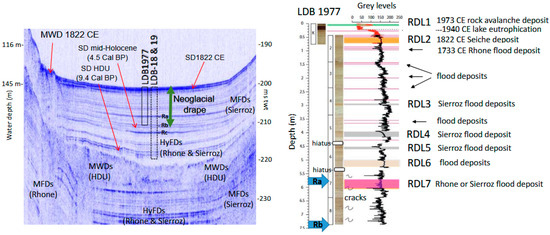
Figure 13.
Lake Bourget deep basin seismic to core LDB 1977 correlation and event stratigraphy. Interpreted seismic profile (left) and LDB1977 sedimentary facies (right) of background sedimentation and intercalated rapidly deposited layers (RDLs). This seismic profile illustrates hyperpycnal flood deposits (HyFDs) and mesopycnal flood deposits (MFDs) originating from the Rhone and Sierroz tributaries. These deposits are exposed to mass-wasting deposits (MWDs), leading to the development of seiche deposits (SDs). The prominent reflections Ra, Rb, and Rc are useful for interpreting the nature and source area of the flood and seiche deposits. They are also used to localize the projected coring sites of cores LDB1977 and LDB 18 and 19 discussed in the text. White rectangles in LDB 1977 are illustrating sedimentary hiatus due to coring disturbances. Blue arrows are locating the corresponding depth of reflection Ra and Rb on core LD 1977. Color bars are illustrating the thicknesses of RDLs in LDB 1977 corresponding to rock avalanche deposit, seiche deposit or flood deposit. When possible the name of the tributary producing the flood deposit is indicated according to the color of the deposit on core LDB 1977 and on the corresponding geometry of high-amplitude reflections resulting from flood deposits on seismic profile, as discussed in the text.
A succession of similar reddish RDLs (up to five layers) is also documented between 470 and 550 cm core depth in the recently published piston core LDB18&19 sequence [102]. This 13.5 m long sequence was sampled with a UWITEC device in 2018 and 2019, in the deep central basin (Figure 13) close to LDB1977 (Supplementary Figure S3). These successive reddish flood layers occurred between 2800 and 2000 cal BP, according to the radiocarbon age-depth model developed for core LDB18&19 [102]. The occurrence of two hiatuses (probably due to coring disturbances) is detected in the core images around 450 cm and 550 cm core depth in LDB1977, limiting the correlations between the LDB1977 and LDB18 & 19 sequences. Further analysis is needed to confirm the nature, age, and sediment sources of RDL 3, 4, 5, 6, and 7.
The Holocene lacustrine drape in Lake Bourget can be subdivided into two acoustic facies. The first is a transparent basal facies matching the Early Holocene lacustrine marls in piston cores LDB01 and LDB04 [31,34]. The second is an upper stratified facies characterized by multiple high-amplitude and continuous reflections resulting from more frequent tributary flood events since the onset of the Neoglacial period (ca. 4.5 to 5 thousand years ago (kyrs), [7]). In the northern basin of Lake Bourget, for example, seismic reflections labeled a, b, and c in Figure 12D correspond to periods of enhanced large Rhone River flood deposits matching “LIA” like cold periods associated with Mont Blanc Glacier fluctuations [31,32,33,34]. Thus, the base of the so-called “Neoglacial drape” is another chronostratigraphic marker horizon on seismic profiles [16]. Below the projected base of LDB1977 on the chirp profile, a seiche deposit is clearly identified (Figure 13). This event occurred at the base of the Neoglacial drape in Lake Bourget and can be correlated with at least two mass-wasting deposits. A thin slump deposit was sampled in LDB04 (in the northern part of the basin) and dated between 4500 and 4600 cal BP [33]. A larger transparent lens-shaped body has not been sampled, but it lies just below the Neoglacial drape at the eastern edge of the eastern central basin [15]. This seiche deposit probably corresponds to one of the RDLs documented in core LDB18&19 between 810 and 850 cm core depth and dated to ca. 4.5 kyrs. The three main seiche deposits in Lake Bourget (1822 CE, 4.5 kyrs and 9.4 kyrs) are thus contemporaneous with multiple coeval mass-wasting deposits remolding either Rhone or Sierroz River flood deposit depocenters along the central basin slopes.
3.6. Lake Geneva Seismic Stratigraphy and Event Stratigraphy
Seismic profiling in the deep basin of Lake Geneva illustrates the asymmetric morphology of the last glacial erosion surface, the variability of its sedimentary infill, and some geological structures of the bedrock (Supplementary Figure S2). Quaternary sediment infill of up to 750 m is documented below the Rhone River and its delta in Lake Geneva near the Sub-Alpine frontal thrust fault (SAF in Figure 4) [28]. Below 300 m water depth, up to ca. 200 m of Late Glacial sediments are imaged at the foot of the southern (French) slopes on profile L2 from 1969, above the complex topography of the Molasse bedrock. However, at the foot of the northern (Swiss) slopes, sparker data reveal only 30 ms twt (ca. 30 m) of postglacial sedimentary infill above the glacial erosion surface below 200 m water depth (Supplementary Figure S4). In this area south of the city of Lausanne, a thrust fault in the bedrock is clearly imaged by sparker data [75] and further illustrates the structural control of the Sub-Alpine Molasse frontal thrust fault (SAMF in Figure 4) on Quaternary glaciation erosion patterns.
The isopack map of lacustrine deposits in the deep basin of Lake Geneva was created by [94] based on a dense grid of multichannel air gun profiles (Figure 7A). It further documents thickness up to 200 ms twt (ca. 150 m) in the central area of profile L2 from [93], and less than 30 ms twt (ca. 15 m) along most of the slopes and in the northern and eastern parts of the basin. According to this map, the bedrock outcrops offshore from the cities of Morges, Rolle, and Yvoire. Lacustrine deposits essentially thicken toward the two main tributary deltas. They are more than 300 ms twt thick (ca. 225 m) and up to 550 ms twt thick (ca. 412 m) in the south western basin where the Rhone delta developed multiple and migrating channel–levee systems feeding distal fan lobes in addition to a large prodelta [96]. Lacustrine deposits offshore of the steep Dranse prodelta are above 100 ms twt (ca.75 m) in the southern part of the basin. Sparker data collected in the central basin are in agreement with this isopack map. These higher-resolution single-channel profiles from 1996 and 1998 illustrate the specific geometry of the central basin fill of Lake Geneva (Supplementary Figure S5). Five main seismic units are here identified above the acoustic substratum (bedrock): glacial deposits (chaotic Unit 1), glacio-lacustrine deposits (chaotic to transparent Unit 2), and lacustrine deposits (stratified Units 3, 4, and 5). Unit 4 is only identified on the valley axis, while Units 3 and 5 are present in most of the central basin, leading to divergent and continuous high-amplitude reflections that thicken toward the Dranse delta. Two main depocenters up to 75 ms twt thick (ca. 56 m) are identified with contrasting geometries: the first depocenter is characterized by migrating channel–levee systems in the deep basin axis in Units 3, 4, and 5, and two channels are also identified on the multibeam bathymetry in front of the Dranse River inlet (Figure 14). The second depocenter is identified along the southeastern slopes of the basin (north of the French towns of Publier and Evian). This depocenter is characterized by localized creeping and the development of listric faults affecting both Units 3 and 5 (Supplementary Figure S5, Figure 14B).
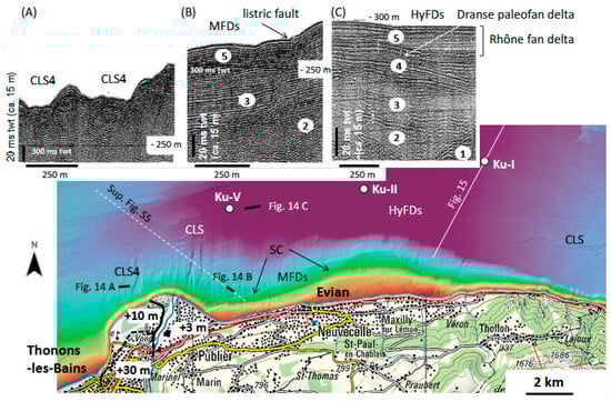
Figure 14.
Dranse delta multibeam bathymetry (from Swiss topo) and selected sparker sections illustrating Lake Geneva seismic stratigraphy (after [77]) and acoustic facies examples of channel–levee systems (CLSs) in the Dranse and the Rhone deltas, Dranse River mesopycnal flood deposits (MFDs), and hyperpycnal flood deposits (HyFDs) developing the Rhone and the Dranse fan deltas. (A) Seismic profile illustrating a paleol Channel Levee System. (B) Seismic profile illustrating acoustic facies of seismic units 2, 3 and 5 discussed in the text. (C) Seismic profile illustrating acoustic facies of seismic units 1, 2, 3, 4 and 5 discussed in the text. The Dranse delta is exposed to a gravity hazard, as shown by slide scars (SC) and listric faults within MFDs. The location of the sparker profile shown in Supplementary Figure S5 (white dotted line), the chirp profiles shown in Figure 15 (white line), and the Ku-I, Ku-II, and Ku-V coring sites (white circles) from [96] are also indicated. The location of the Late Glacial +30 m (black dotted line) and +10 m (black line) to Holocene +3 m terraces are discussed in the text.
Two channel–levee systems are visible along the northern slopes of the Dranse delta in bathymetric data and sparker data (Figure 14A). However, these systems are no longer connected to any tributaries from the Dranse Delta and are likely inactive today (paleochannels). They were likely active during the formation of Unit 4 on the basin axis (see the Discussion section). Downstream from the active channels facing the Dranse River inlets, distal fan lobes are also identified in Units 4 and 5 (Figure 14 C). While Unit 4 fan lobes thin eastward, Unit 5 fan lobes thicken eastward. This suggests that Unit 4 was only linked to the Dranse delta sediment supply, while Unit 5 accumulated both Dranse and Rhone River distal flood deposits (i.e., interfingering fan lobes). This interpretation is strongly supported by the identification of Dranse River flood turbidites since 563 CE in core Ku-V and a combination of both Dranse and Rhone River flood turbidites in core Ku-II, as well as only Rhone River flood turbidites in core Ku-I [96].
Slide scars are also identified in the bathymetric data (around 200 m water depth) offshore from the city of Evian (Figure 14). In addition, late Holocene mass-wasting deposits at the foot of the southern slopes, originating from this part of the basin, were documented in the 3.5 kHz pinger data [103]. These mass-wasting deposits originating from the Dranse River mesopycnal flood deposits were coeval with a major mass-wasting event off the coast of Lausanne. This event was dated at the base of core Ku-IV (Figure 7) and possibly explained by an earthquake–mass movement–tsunami event during the Early Bronze Age [103]. The base of this catastrophic Bronze Age event is identified in the pinger data at 460 ms twt in the deep central basin of Lake Geneva.
As shown in Figure 15, the Knudsen 4 kHz chirp data penetrated down to 460 ms twt in this part of the lake and imaged up to five RDLs, including the Bronze Age event (RDL5) and the 563 CE Tauredunum event (RDL3), which were discovered, sampled, and dated in [48,82,96,103]. These RDLs are characterized by a transparent acoustic facies, and RDL1, 2 and 3 have an irregular upper limit as clearly imaged by the EXAIL compact Echoes 10,000 chirp data (Figure 15A). These are the typical signatures of a debrite (mudclast conglomerate) catastrophic deposit, according to [48,104]. The Tauredunum event (RDL3) is ca. 6 m thick in this part of the lake, as shown by the 4 kHz chirp data (Figure 15A). As mentioned in [48,82,96,103], the 563 CE debrite is also characterized locally around 435 ms twt on Knudsen chirp data by a low-amplitude and discontinuous reflection matching the transition from the basal conglomerate to the massif upper sedimentary facies, as identified on published 4 kHz data and in cores Ku-I, Ku-II, and Ku-IV (Figure 7). Between the Bronze Age event (RDL5) and the Tauredunum event (RDL3), a similar, thinner, transparent layer (RDL4) was identified at around 445 and 447 ms twt (Figure 15B). This event was possibly sampled at core Ku-IV between the tsunamigenic Tauredunum event and the Bronze Age deposits at 7 to 7.4 m core depth [103]. This thinner event layer is dated to around 2300 cal BP during the Iron Age, a period when different fragmented Celtic tribes inhabited the Western Alps. Thus, this Celtic event (RDL4) likely resulted from the destabilization of deltaic deposits and the deposition of a debrite in the deep central basin. Above the Tauredunum event, two thinner, transparent to chaotic lens-shaped bodies are identified in both the 4 kHz and 10 kHz chirp data in the central basin (Figure 15). RDL2 develops transparent facies (up to 1 m thick) in the southern central part of the basin. It is laterally associated with a high-amplitude and continuous reflection (around 250–300 cm below the lake floor) that was sampled by core Ku-I (Figure 15A). This seismic horizon matches horizon r5 documented by [96], and is correlated with a coarse-grained and graded event layer (turbidite t4) identified in cores Ku-I, Ku-II, Ku-IV, and Ku-V. This event deposit highlights both variable sedimentary facies and thicknesses in these cores and has been dated by radiocarbon to between 1220 and 1420 CE (530 and 730 cal BP; 1400 +/− 100 CE, [96]). However, paleomagnetic secular variations from core Ku-IV, just below this turbidite originating from the Rhone delta, suggest that it occurred shortly after 1540 +/− 70 CE [97]. RDL 1 is a small, chaotic, lens-shaped body that is locally identified between 0.5 and 1 m below the lake floor (Figure 15) and was never sampled by coring.
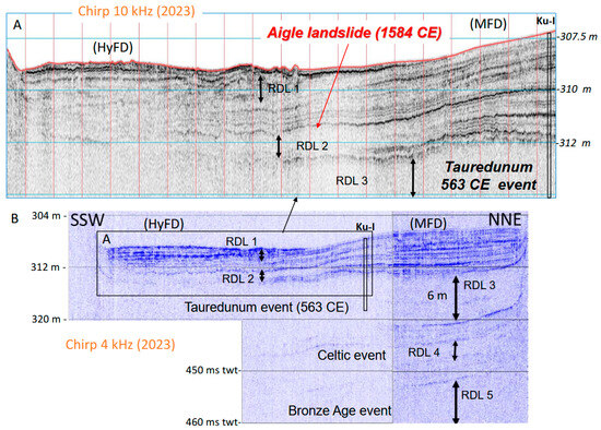
Figure 15.
Lake Geneva central basin seismic profiles and event stratigraphy based on high-resolution Chirp data collected in 2023 across the Rhone fan delta. (A) Echoes 10,000 compact profile. (B) Knudsen 4 kHz Pinger profile. These two complementary profiles were obtained at identical locations and calibrated using data from the piston core Ku-I, as illustrated in Figure 14. Up to five rapidly deposited layers (RDLs) are identified and correlated with former sediment cores and 3.5 kHz data in the area, according to [80,94,102]. Contrasting acoustic facies characterize Rhone River hyperpycnal flood deposits (HyFDs) and mesopycnal flood deposits (MFDs). The correlation of the upper part of the Bronze Age event (RDL5) and the Tauredunum event (RDL3) allows us to better understand the impact of the Aigle earthquake in 1584 CE (RDL2) and to discuss the triggering of a poorly documented Celtic event (RDL4), as discussed in the text.
Figure 15 illustrates two distinct Rhone River flood deposit depocenters in the 10 km wide, deep and flat central basin of Lake Geneva. In the (deepest) southern part of the basin, several high-amplitude and continuous reflections develop lenses that are locally disturbed in RDL1. This geometry is typical of lacustrine fan delta lobes [56,57,75]. The acoustic signal is quickly absorbed ca. 4 m below the lake floor in both the 10 and 4 kHz chirp data, suggesting that these deltaic deposits are essentially composed of relatively coarse-grained sands. From the Rhone River inlet and its prodelta, a channel–levee system is clearly visible on the lake floor in both the 4 kHz chirp and multibeam bathymetric data down to this part of the deep central basin (Figure 14). Laterally and toward the NNE sector of the deep basin, sediments develop high-amplitude and high-frequency continuous reflections illustrating a draping and slightly divergent geometry (thickening toward the NNE). This acoustic facies was sampled by core Ku-I and interpreted as distal Rhone River flood deposits with a few coarser and thicker turbidites (labeled t2 and t4 by [96].
3.7. Lake Constance
In Lake Constance, it has been clearly documented by [99] that the Rhine River delta sediments limit seismic signal penetration near the lake’s inlet (proximal Rhine delta, Figure 5). The authors also illustrated how the Rhine delta developed a meandering channel–levee system along the basin axis that disappears in the deep, flat, and narrow (ca. 1.5 km wide) distal basin. There, fine-grained sediments develop a laminated acoustic facies with continuous horizontal and high-frequency reflections on 3.5 kHz data. This Rhine River channel–levee system is also clearly visible in Lake Constance multibeam bathymetry [85,100]. As shown in Figure 5 and Figure 16, digital 3.5 kHz pinger lines 1 and 2, published in [85,87], were acquired across the central basin and calibrated by long piston coring (HIBO-19 and B0-91-08).
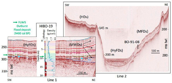
Figure 16.
Distal Rhine delta acoustic facies (3.5 kHz) calibrated by piston core data (B0-91-08 and HIBO-19), illustrating specific depocenters in the deep basin of Lake Constance for mesopycnal flood deposits (MFDs) and hyperpycnal flood deposits (HyFDs), contrasting with hemipelagic sediment deposits (HDs) (modified after [84,85,87]). A few mass-wasting deposits (MWDs) are visible at the foot of the northern slope of Lake Constance. The Flims outburst flood catastrophic deposits (green arrow) produce a specific reflector (F) colored in green. The lower MWD is laterally associated with a turbidite deposit sampled in core HIBO-19 (producing a peak in sediment density) and visible on seismic profile as a specific reflector (M) colored in blue. On core HIBO-19 several contrasting sedimentary facies are illustrated by pink, purple and blue boxes as discussed in the text.
These data illustrate how the Flims outburst flood deposit developed on Line 1, a continuous high-amplitude reflection ca. 9.5 m below the lake floor in the deep and flat central basin. This horizon contrasts with the Early Holocene sediments, which have a transparent acoustic facies, and the Mid to Late Holocene deposits with lower-amplitude continuous and high-frequency reflections sampled by core HIBO-19. Below 11 m core depth, coarser and denser Late Glacial sediments prevent the penetration of the acoustic signal. Locally, three generations of Holocene mass-wasting deposits originating from the NE slopes of the basin produce small lens-shaped bodies with chaotic to transparent acoustic facies thinning toward the basin axis (ca. 10 m; 5 m and 2 m below the lake floor). A sandy turbidite sampled at around a 10 m core depth in HIBO-19 is dated to around 11 kyrs [85] and is associated with a prominent high-amplitude reflection (reflector M in Figure 16) that laterally matches the southwestern edge of the older mass-wasting deposit.
Line 2 illustrates how the deep and flat sedimentary infill of the central basin produces a specific acoustic facies and a depocenter contrasting with the geometry of the basin slope deposits. Toward the SW, a lacustrine drape ca. 10 ms twt (7.5 m) thick with a transparent acoustic facies is visible above the acoustic substratum, developing an irregular subaquatic plateau at around 140 m water depth (Figure 16). The acoustic substratum becomes much steeper toward the basin axis and outcrops along the basin slopes facing the deep and flat central basin. Along the NE basin slope, the acoustic substratum is characterized by gentle and irregular morphology. It is draped by a thick sediment depocenter up to 20 ms twt (ca. 15 m), identified between 90 and 200 m water depths. This depocenter exhibits low-amplitude continuous reflections. These sediments were sampled by piston corer at B0-91-08 and interpreted as distal Rhine River flood deposits [84].
4. Discussion
4.1. Architecture and Chronology of the Perialpine Lakes Deltaic Depocenters
Large glacial lakes formed at the piedmont of both the Northern Pyrenees and the Western and the Northern Alps (Figure 2, Figure 3, Figure 4 and Figure 5) following the Last Glacial Maximum [23,28,55,56,57,59,60,63,75,76,84,85]. During the Late Glacial period, climate changes favored glacier melting and their retreat upstream from most large European glacial valleys. A large sediment supply from numerous braided fluvio-glacial streams caused large volumes of clastic sediments to accumulate in European piedmont and perialpine lakes. Large subaquatic deltaic depocenters formed in these lakes during this period through the accumulation of hyperpycnal flood deposits in their deep glacial basins (Figure 1 and Figure 17) [56,57,75].
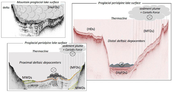
Figure 17.
General conceptual model of tributary flood processes shaping proximal to distal deltaic lacustrine sediment depocenters in mountain and perialpine proglacial lakes. Proximal deltaic deposits in mountain lakes result from homopycnal flood deposits (HoFDs) and hyperpycnal flood deposits (HyFDs) and are exposed to mass-wasting deposits (MWDs) triggered by earthquakes or catastrophic snow avalanches. Both proximal and distal perialpine deltaic deposits resulting from hyperpycnal or mesopycnal flood events (mesopycnal flood deposits, MFDs) can generate tsunamigenic MWDs, which are possibly triggered by earthquakes. The circles with a cross are illustrating flood currents heading toward the bottom of the picture. Catastrophic rockfalls, either near a perialpine inlet or higher up in the drainage basin across the glacial valley streams, can also trigger tsunamigenic MWDs in perialpine lakes or catastrophic outburst flood deposits related to the rupture of a landslide dam and the drainage of the impounded lake temporarily formed upstream of the rock avalanche deposits.
As shown in Figure 3, Figure 4 and Figure 5, all of the large Pyrenean piedmont lakes and several former large lakes in the alpine glacial valleys (Isère, Arve, Upper Rhone, and Upper Rhine) are today completely filled up by prograding Late Glacial tributary deltas and have become large alluvial plains [76]. In large perialpine lakes, prograding deltas from the Leysse, Sierroz, and Rhone rivers in Lake Bourget ([31,56,75,76], this study), the Fier River in Lake Annecy [57], and the Dranse River in Lake Geneva ([75,94], this study) were associated with migrating channel–levee systems along deltaic subaquatic slopes and the accumulation of distal fan lobes in deep basins. These basins were fed by powerful and frequent hyperpycnal flood events (Figure 17). According to [99], the deep and narrow basin of Lake Constance contains numerous coarse-grained layers documented by [85] during the Late Glacial period in core HIBO-19 (Figure 16). These layers likely correspond to proximal fan lobe deposits that absorb the 3.5 kHz pinger acoustic signal. In the less deep (but wider) central basin of Lake Bourget, Late Glacial hyperpycnal flood deposits from the Rhone and Sierroz Rivers develop high-frequency and high-amplitude horizontal reflections in the basin axis (cf. Figure 12 and Figure 13). Similarly, the Leysse River’s Late Glacial hyperpycnal flood deposits developed horizontal high-amplitude reflections in the southern sub-basin of Lake Bourget (below the Holocene lacustrine drape), but these flood deposits never reached the deepest and central basin [31,56,75]. During the Late Glacial period, the progradation of the Dranse delta in the central basin of Lake Geneva locally formed a terrace located 10 m above the present-day lake level [105] (Figure 14) and the subaquatic channels from the Dranse delta that are still visible in the bathymetry but are disconnected from any present-day tributary (CLS4 in Figure 14A). Former Dranse River channel–levee systems are also identified on sparker profiles within Lake Geneva Unit 4 downstream from these fossil channels in the deep central basin (Supplementary Figure S5 [75]). These channel–levee systems evolve downstream into small fan lobes with a lenticular geometry. According to [75,105], these former terrestrial and subaquatic (proximal and distal) deltaic deposits and morphologies were probably formed when the floating front of the Rhone glacier still covered the eastern part of the central basin of Lake Geneva.
Another type of deltaic sediment depocenter is well-stratified and identified within Late Glacial deposits only on the right-hand side of lake tributaries (Figure 12B–D and Figure 13). According to [56,57], these deposits in Lakes Bourget and Annecy resulted from the influence of the Coriolis force on fine-grained sediment plumes originating from lake tributary floods. These flood sediments were trapped above the lake thermocline, developing mesopycnal flows over several kilometers in the lakes during warmer periods. However, such Rhone River flood depocenters were exposed to gravity reworking processes and are poorly preserved in Lake Bourget [75,89].
During the Holocene, hemipelagic deposits generally develop a sediment drape on gentle subaquatic slopes that are located far from permanent tributaries of lakes, as is clearly documented in the perialpine Lakes Bourget (Figure 12C–E and Figure 13) and Constance (Figure 16). These deposits were sampled using sediment cores and consist of lake marls that are rich in authigenic carbonates [31,34,54,75,84,85]. These marls were well developed and documented in numerous perialpine lakes during the Early Holocene and the Holocene Climate Optimum, when warmer waters favored carbonate precipitation and dense vegetation cover limited soil erosion. In Lakes Constance, Geneva, and Bourget, the lacustrine drapes thicken towards the tributaries of the Rhine, Rhone, Dranse, Leysse, and Sierroz. In Lake Bourget, successive high-amplitude reflections are identified and interbedded within this Holocene lacustrine drape following the onset of the Neoglacial period, characterized by a wetter climate [31,33] and enhanced human impact on vegetation cover, land use, and erosion rates [34,102]. Periods of enhanced Rhone River hyperpycnal and mesopycnal flood deposits in Lake Bourget are evident in sediment cores and have developed specific deltaic depocenters (Figure 12). Channels are also identified in proximal deltaic environments in front of Lake Bourget’s permanent tributaries (i.e., on Leysse and Sierroz deltas) using bathymetry and side scan sonar data [75]. Well-developed Holocene (and present-day) channel–levee systems illustrated in Figure 17 are documented only in Lakes Geneva and Constance and subaquatic proximal deltaic environments of the Rhone, Dranse, and Rhine. These features result from frequent and powerful hyperpycnal floods transporting suspended sediment loads from tributaries down to the deep basin fan lobes, as illustrated in the central basin of Lake Geneva (Figure 15).
Frequent and powerful mesopycnal floods during the Holocene developed stratified sediment depocenters in the proximal and distal deltaic environments on the right side of the tributary inlets of Lakes Bourget, Geneva, and Constance (Figure 12B,D, Figure 15, Figure 16 and Figure 17, Supplementary Figure S2). As discussed below, these mesopycnal flood deposits were frequently exposed to gravity reworking phenomena (subaquatic slides) in both Lakes Bourget and Geneva. The enhanced Rhine River mesopycnal flood deposits on the northern slopes of the Lake Constance central basin after 5 kyrs are considered to reflect the runoff of the Rhine River. At this site, the increasing thicknesses of the flood deposits from Mid to Late Holocene likely reflect the progradation of the Rhine delta [84] and the onset of the Neoglacial period. In Lake Constance, the Rhine River mesopycnal flood deposits are apparently more stable and were exposed to only a few limited subaquatic slides, as reflected by the moderate thickness and surface area of mass-wasting deposits at the base of the northern basin slopes (Figure 16).
4.2. Architecture and Chronology of Mountain Lakes’ Deltaic Depocenters
The mountain lakes Blanc and Orédon in the Alps and the Pyrenees are characterized by a similar seismic stratigraphy. This seismic stratigraphy was previously documented in other Alpine mountain lakes in the western Alps (Figure 4), such as the proglacial lakes Blanc Huez [6,11] and Bramant [12]. The seismic stratigraphy was also calibrated using piston coring that sampled basal glacial till and contrasted laminated lacustrine deposits [106]. Above a glacier erosion surface, all these glacial basins accumulate glacial deposits that locally develop a chaotic to transparent unit (CU) in the basin axis. Downstream from their tributary deltas, these lakes are then filled by a transparent unit (TU) consisting of laminated and organic-rich sediments and a thicker stratified unit (SU) made of laminated and minerogenic sediments. Both TU and SU are pounded in the deepest part of the basin and exhibit a divergent geometry, thickening toward the tributary delta and thinning toward the lake outlet. They are thus the products of clastic-dominated lacustrine sedimentation, accumulating eroded material from the drainage basin. All of these mountain lakes drain cirque glaciers, several moraine ridges of Holocene age, glacial deposits, and thin soils. In addition, both the Alpine and Pyrenean mountain lakes (Bramant and Orédon) have drained lacustrine environments (upstream lakes and paleolakes). All these lakes drained glaciers during the LIA. While these glaciers have completely melted in the northern Pyrenees, they are quickly disappearing in the western Alps. Similar to other proglacial European mountain lakes in the Swiss central Alps [107] and Western Scandinavia [22,24,46], which drain larger glaciers, the succession of Holocene organic-rich to minerogenic lacustrine sediments in proglacial lakes is interpreted as resulting from the onset of the Neoglacial period. During this period, enhanced glacier activity and bedrock erosion in the drainage basins were associated with lowered glacier Equilibrium Line Altitudes (ELAs) during wet periods [6,11,12,46]. In both Scandinavia and the Alps, the Neoglacial period started during the Mid-Holocene and was characterized by fluctuating glacier activity during the Late Holocene, which culminated during the LIA [7,33]. In Lake Orédon, the onset of SU is interpreted as resulting from the onset of the Neoglacial period, but its chronology has not yet been established. However, it is clear that the main glacier fluctuations during the Neoglacial in the central northern Pyrenees occurred during the Late-Holocene but before the LIA [62].
In Lake Fourcat, the seismic stratigraphy of the basin is composed solely of laminated, organic-rich lacustrine sedi ments developing a TU above the bedrock, and an SU is not observed here. This mountain lake and its glacial cirque likely deglaciated during the Early Holocene, similar to the nearby Picot glacial cirque and the upper Picot Lake [17]. This small mountain lake drains only the smaller Lake Oussade, and its drainage basin consists of outcropping granitic bedrock and thin soils, but is free of moraines (Figure 6). As shown by Fourcat sediment pyrolysis, Fourcat lacustrine sediments are essentially composed of terrigenous organic matter eroded from soils (Figure 10). Lake Fourcat is likely characterized by a very low Holocene accumulation rate of organic-rich sediments, similar to other oligothrophic Pyrenean mountain lakes, such as the nearby Lakes Bassies [7] and Redon [108]. These Pyrenean mountain lakes all drain reduced drainage basins and are generally frozen and snow-covered from late autumn to early summer.
As previously documented in the Alpine proglacial lakes of Blanc Huez [6,11], Bramant [12], and Blanc [13], tributary floods in mountain lakes following snowmelt and/or rainstorms develop either homopycnal or hyperpycnal flood deposits (Figure 1 and Figure 17). These flood events are more powerful and rich in suspended sediment loads when draining glaciated drainage basins, favoring the progradation of steep delta fronts and the deposition of a SU in proglacial lakes. Mountain lakes depositing a TU are likely not significantly influenced by glacier activity or are frequently exposed to hyperpycnal flood events following snowmelt or rainfall. Rather, they are dominated by weaker homopycnal flood events. The recent construction of dams and the artificial fluctuations in lake levels impact the composition and remobilization of coastal sediments, the mean accumulation rates, and eventually the trophic status of these lakes [7,12]. However, these changes did not affect the dominant deltaic sedimentary processes, such as the development of either a TU or a SU, according to their geomorphological setting [7,11,12,106].
4.3. Lacustrine Stratigraphic Signatures of Terrestrial and Aquatic Abrupt Gravity Reworking Events
Snow avalanche deposits can be documented in the sedimentary infill of mountain lakes when they represent erosive events transporting rock debris on the frozen lake surfaces [44,106]. When the frozen surface of the lake melts, the debris produces drop stones in lacustrine deposits. These drop stones are centimeters in size and are typically characterized by angular shapes. Such deposits are frequently identified both in Lake Fourcat and Orédon in the northern Pyrenees and in Lake Blanc in the western Alps during historical and Holocene times. In addition, frequent Holocene larger wet snow avalanche deposits, developing decimeter-thick, coarse-grained, and massive deposits (a mixture of pebbles, gravel, and sand) interbedded within lacustrine sediments, have been documented and dated in proglacial Lake Lauvitel in the western Alps (Figure 4) [45]. A catastrophic snow avalanche impacted Lake Blanc in the Aiguilles Rouges massif in 1986 CE [13]. This violent event partly destroyed a mountain refuge on the lakeshore (Supplementary Figure S6). As detailed in [13], this snow avalanche broke the lake ice and induced a large mass-wasting deposit (RDL1), which is visible on the lake floor at the front of the Lake Blanc delta and in the lake basin (Figure 11). The impact of the snow avalanche remobilized recent lacustrine deltaic deposits (post-1950 CE) rich in 137Cs, but not in rock debris.
Rockfall deposits can be documented in both mountain and piedmont lakes sedimentary records, regardless of the size of the lake or the landslide, when the rockfall directly impacts the lake, its outlet, its deltaic plain, or its drainage basin. In 1936 CE, a spontaneous and catastrophic rockfall event (ca. 1 million m3 of rock and debris) initiated at an altitude of 800 m above the proglacial Lake Lovatnet (western Norway) hit this ca. 10 km2 large lake [29]. This event triggered a tsunami wave up to 74 m high, as well as a subaquatic rockfall deposit visible on the multibeam bathymetry of the lake floor and a tsunami deposit visible (below 92 m water depth) in a distal basin on sediment cores and sub-bottom profiles (as further discussed below). On 7 August 1973, a much smaller rockfall (ca. 20,000 m3) triggered by explosives to protect the railway (the so-called La Casquette event) formed both subaerial (Figure 12G) and subaquatic (Figure 12H) rockfall deposits (ca. 90,000 m2 according to side-scan sonar mapping) in Lake Bourget, in addition to a rock avalanche deposit. This deposit resulted in the deposition of a subaquatic turbidite (RDL1 on the LDB 1977 core) that spread over ca. 2 km2 in the deep central basin (Supplementary Figure S3). Nearby Grésine Bay in Lake Bourget, sub-bottom profiles locally (and at the same depth below the lake floor) illustrate a specific acoustic facies, producing sporadically chaotic, very high-amplitude reflections (Figure 12E) downstream from small gullies (visible at the lake shore on a steep cliff formed by outcropping bedrock) and from small canyons visible in the bathymetric data. These specific layers were not sampled, but they likely resulted from localized subaquatic rockfall deposits during the Holocene, originating from the contemporaneous destabilization of steep slopes above Lake Bourget along the eastern shore of the Grésine Bay. In the Western Alps, a large Mid-Holocene rockfall deposit (ca. 12 × 106 m3) was also recovered at the outlet of proglacial Lake Lauvitel [109]. Since this rockfall event, the lake has been characterized by fluctuations in lake levels of up to 20 m every year following snowmelt, because the rockfall dam consists of large blocks and is thus permeable [45,109]. According to [30,48], the historical catastrophic Tauredunum rockfall (of unknown exact size) hit the Rhone River deltaic plain near Lake Geneva (Figure 7) in 563 CE. The impact shock waves triggered by this event within (water saturated) fluvial and lacustrine deltaic deposits caused a large subaquatic slide that remolded the Rhone proximal delta lacustrine deposits. These deposits evolved into a tsunamigenic debrite reaching the deep central basin of Lake Geneva. This catastrophic debrite is very large and thick, clearly visible in the deep basin sub-bottom seismic profiles (Figure 15) and sediment cores [48]. The Flims rockfall event (ca. 12 km3) in the Rhine River glacial valley, ca. 80 km upstream from Lake Constance, evolved into a catastrophic rock avalanche. This avalanche dammed the Rhine River, forming the temporary Lake Illanz [46,83], as shown in Figure 5. The Flims event occurred around 9400 cal BP according to the radiocarbon ages of wood debris at the base of the avalanche deposit and at the base of the sedimentary infills of two relatively small lakes formed on the Flims deposit [83]. Thus, this age matches the calculated age for two successive outstanding hyperpycnal outburst flood deposits sampled in the deep basin of Lake Constance in 1991, 1994, 1997, and 2014 [46,84,85]. Additional 36Cl and 10Be exposure ages on large blocks confirmed the age of the major Flims event around 8900 +/− 700 years [86]. The rupture of this temporary dam across the Rhine River thus induced catastrophic outburst flood events and formed two exceptional hyperpycnal flood deposits in the deep central basin of Lake Constance (Figure 16), located more than ca. 100 km from the Flims rock avalanche deposit [46,85,87]. The Mont Granier rockfall in 1248 CE had a more localized impact in the western Alps (Figure 4). This rockfall (ca. 3.5 × 10⁸ m3) is the largest historical event in the Alps [78]. It was triggered at the onset of the LIA and evolved into a catastrophic debris flow that formed Lake Saint André (12 m deep, ca. 87 ha) in one of the topographic depressions developed by the debris flow deposit [110]. However, the Mont Granier event did not impact any fluvial networks, unlike the Dent du Marais event (ca. 7. 106 m3) in the French Central Massif, which dammed the Chaudefour River [111]. This largest landslide in the Central Massif occurred ca. 1280 CE due to a rockfall that evolved into a debris flow that formed several very small and shallow lakes on topographic depressions (and above a landslide dust layer). This landslide also impacted the distal part of Lake Chambon. Consequently, the landslide raised the altitude of the outlet (and thus the level) of Lake Chambon in the Chaudefour glacial valley [111]. In the Chablais subalpine massif (Figure 4), relatively large recent and historical landslides in the Dranse River drainage basin formed the two relatively small lakes, Montriond and Vallon, that seem to be stabilized. However, the large, ongoing Argentière rock slope failure near the city of Chamonix (Figure 4) may impact in the future the drainage basin of the Arve River originating from Mont Blanc glaciers. This rock failure could therefore induce large (temporary) dam lakes and (catastrophic) outburst floods, potentially impacting the city of Geneva and the multiple hydroelectric reservoirs in the upper Rhone River valley in France. Eventually, the floods reached Lake Bourget (Figure 1). In the Pyrenees, the large documented rockfalls localized in Figure 3 do not significantly impact aquatic environments [49,62], although a small and isolated mountain lake was formed on top of a deep-seated landslide triggered by the 580 CE Lavedan earthquake [49].
4.4. Stratigraphic Signatures of Tsunami and Seiche Waves in Lakes
Sub-aerial and subaquatic slope failures can induce lacustrine tsunamis (tsunamigenic slides) in mountain and piedmont lakes and induce seiche waves in some cases. These waves are rare, powerful, and violent, impacting coastal and deep water sedimentary environments [48,53,54,82,112]. The generation and impact of these powerful waves can be documented by a range of gravity reworking deposits in lacustrine sedimentary records, depending on the size and geometry of the lake, as well as its geomorphology and the size and source area(s) of the landslide.
Historical and pre-historical lacustrine tsunami deposits have been documented in seismic profiles and sediment cores [19,29,82,96,112,113]. At the foot of steep slopes, tsunami deposits are typically identified by multiple subaquatic mass-wasting deposits that evolve into debris flows and megaturbidites in the deep basins. Backwash tsunami deposits can also be identified by erosive coastal sandy layers exported in shallow bays [19,43] or deeper sub-basins [29]. Depending on the basin geometry, the tsunamigenic mass-wasting deposits can be marginal and disconnected from the megaturbidite or partially covered by it (in a confined basin). For example, this occurred in the very large Lake Nahuel Huappi in northern Patagonia following the 1960 Valdivia earthquake-induced tsunami wave [19]. However, numerical modeling suggests that the dispersive effects of subaquatic tsunamigenic slides may be negligible in relatively small lakes (like Lake Aiguebelette, Figure 4), which could thus generate higher tsunami waves. Following the Tauredunum rockfall in 563 CE on the Rhone delta next to Lake Geneva, the induced subaquatic tsunamigenic slide on the Rhone delta proximal slopes did not generate a megaturbidite, but rather a very large debrite in the deep basin [82], characterized by transparent acoustic facies and an irregular upper boundary clearly visible on high-resolution seismic profiles (Figure 15). According to [104], it is likely that, in 563 CE, the lake floor from this part of the Rhone delta to the deep central basin was not characterized by a clear slope break and was therefore not suitable for generating a turbidity current. This was probably not the case during the Bronze Age tsunamigenic slide that was initiated on the steep slopes off the coast of Lausanne [103]. Chirp profiles from the central basin of Lake Geneva do not allow for proper imaging of the upper boundary of the Bronze Age event (Figure 15). However, according to multichannel seismic data and 3.5 kHz pinger data [103], the Bronze Age tsunamigenic event is characterized by multiple mass-wasting deposits partially covered by a transparent acoustic unit with a sharp upper boundary, which is typical of megaturbidites. Today, this horizon is located around 20 m below the lake floor in the 308 m deep central basin of Lake Geneva, but it has never been sampled by piston coring.
Historical and pre-historical seiche deposits in glacial lakes were documented using seismic and core data [10,15,16,36,37,43,54,56,81,104,114,115]. Seiche deposits are a type of megaturbidite (or homogenite) formed in association with tsunamigenic slides in deep lacustrine basins. They are also controlled by the development and dissipation of standing oscillatory waves (i.e., seiche waves). Seiche deposits are always found in the deep part of a lake basin and are characterized on seismic profiles by a basal high-amplitude continuous reflection and a relatively thick transparent upper unit draping and ponding the lake floor topography and developing a very flat upper boundary, as illustrated in Figure 13. In the cores, the base of a seiche deposit consists of multiple sandy layers that quickly evolve into a massive muddy turbidite. A sandy base can be formed by littoral particles (i.e., products of a tsunami backwash) or remobilized sands from slope failures and mass-wasting events. These sand layers can be deposited under relatively turbulent conditions in the deep basin during standing oscillatory waves (over a couple of hours or days, depending on the seiche amplitude and the lake morphology). However, the homogeneous muds result from the massive settling of the fine sediment fraction (i.e., silty clays that were resuspended during the slope failures and mass-wasting processes and kept in suspension above the lake floor by the oscillatory waves) once the seiche waves diminish. Consequently, seiche deposits can be distinguished from muddy turbidites based on their geometry (in non-confined basins), their grain size (skewness and sorting), as well as their sedimentary fabric, as reflected by sediment magnetic anisotropy (foliation and lineation parameters) [16,75,114,115].
4.5. Stratigraphic Signature of Earthquakes in Lakes
Since gravity reworking in mountain and piedmont lakes could be initiated by different processes, one of the strongest arguments for assigning seismic triggering to a sedimentary event with a specific geometrical and sedimentological signature in a lake is correlating it with a well-documented historical earthquake [6,7,11,12,13,14,15,19,21,33,36,41,50,51,52,53,81,104,111,113,115]. A key impact of strong earthquakes in mountain ranges is triggering multiple coeval subaquatic slope failures in lakes. In large (piedmont) lakes, several slides have been identified in sub-basins or at the foot of several subaquatic deltaic slopes from a single basin following strong earthquakes. In our study areas, seiche deposits in Lakes Lucerne and Bourget, induced by earthquakes and seiche effects in 1601 CE (Figure 5) and 1822 CE (Figure 4), respectively, have been extensively documented through acoustic mapping, sediment core analysis, and numerical modeling [10,15,33,36,43,53,54,81,89,91,92,103,104]. Numerical simulations coupling coseismic displacement, seismic wave propagation, and tsunamigenic mass movements (tsunami model) in Lake Bourget following the 1822 earthquake are supported by sedimentological and historical observations [15,43,54]. These simulations can provide a better understanding of the dominating physical processes induced by an earthquake in a glacial lake. The two main subaqueous landslides triggered by the 1822 CE earthquake generated local tsunami waves, with a maximum runup of ca. 2.5 m. However, seismic wave propagation (originating from the Culoz fault) in this fjord-lake was the primary driver of the seiche waves that formed the 1822 CE seiche deposit [43] in its confined central basin (Figure 13). In the Aiguilles Rouges Massif, the age–depth model of core BAR10-II in Lake Blanc allows correlating RDL2, RDL3, and RDL4 (Figure 11) with historical regional earthquakes. As detailed in [13], RDL2 is contemporaneous with the 1905 CE Emosson earthquake in Switzerland (Figure 4). Similarly, RDL3 matches the 1817 CE Chamonix earthquake in France, and RDL4 matches the 1584 CE Aigle earthquake near the Rhone River delta of Lake Geneva (Figure 4). In the Pyrenean Lake Orédon, the lower unit of core ORE-15, which correlates to a mass-wasting deposit originating from its steep delta slope (Figure 9 and Figure 10), is dated to 1592 +/− 55 CE. This deposit can be attributed to the 1660 CE June 21 Bagnère-de-Bigorre earthquake (Figure 3), one of the most destructive historical earthquakes in the Pyrenees (estimated magnitude Mw 6.1). In the deep central basin of Lake Geneva, RDL2, as identified on chirp profiles (Figure 15), is laterally associated with a high-amplitude and continuous reflection labeled r5 by [96]. This reflection was sampled by core Ku-I and correlated to a turbidite layer (t4) identified in cores Ku-II, Ku-IV, and Ku-V (Figure 7). According to [96,97], this turbidite is now dated to 1540 +/− 70 CE. These authors interpret RDL2 and t4 as a small debrite laterally evolving into a turbidite triggered by the nearby 1584 CE Aigle earthquake (Figure 4 and Figure 7). This regional earthquake caused several catastrophic and specific phenomena in the area [116]. A tsunami occurred in the region of the Rhone delta, as well as in the cities of Lausanne and Geneva, causing flooding and damaging watersides in Villeneuve, Lausanne, and Geneva. The temporary draining of the Rhone River in the city of Geneva indicates the development of a seiche effect (more than five feet) after the tsunami. Lake Geneva RDL2 and t4 might also be associated with a larger mass-wasting deposit documented near the Rhone delta [95,116] using 3.5 kHz profiles and piston cores J-34 and J-35 (Figure 7). This mass-wasting deposit located ca. 4 m below the lake floor likely originated from the Rhone proximal deltaic deposits and was dated to 1600 +/− 100 CE based on the extrapolation of a mean sedimentation rate (estimated from 14C ages together with 137Cs and Hg profiles). This large slope failure near the Rhone delta was likely tsunamigenic and triggered by the Aigle earthquake located only 12 km from the Rhone inlet and 20 km from the J-34 coring site. According to [116], an aftershock also induced a catastrophic rockfall near the epicenter, destroying 69 houses in two different villages (Corbeyrier and Yvorne) and killing about 320 people and several hundred animals. This earthquake also induced RDL4 in Lake Blanc, located ca. 40 km from the epicenter in the Aiguille Rouges Massif [13]. The Aigle earthquake was an important, well-documented regional event in the western Alps that induced multiple hazards. It occurred during a period when the area was already significantly populated.
Paleo-earthquakes can also be proposed as a triggering mechanism for prehistoric gravity-reworked deposits (i.e., seismites) in lakes. These deposits occur further back in time (when no more historical data is available). They are similar to historical seismites and/or contemporaneous slope-failure deposits in a single or several lake basins at a regional scale. This approach has been widely applied in the Alps and in other mountain ranges, but not yet in the Pyrenees. This study illustrates up to five mass-wasting deposits stacked at the foot of Lake Orédon (Figure 9). The youngest deposit is related to the major historical earthquake that occurred in the northern Pyrenees in 1660 CE. It is possible that four paleo-earthquakes have impacted this area since the onset of the Neoglacial period. Future studies based on long cores are required in Lake Orédon and the connected reservoirs, Cap de Long, Aubert, and Aumar (Figure 6), to better evaluate the Late Holocene seismic hazards in this part of the Central Pyrenees, which has been significantly impacted by hydroelectric activities since the onset of the Anthropocene. For instance, three prehistorical regional earthquakes in the northern Alps were documented by numerous coeval subaquatic mass-wasting deposits in Lakes Zurich and Lucerne around 14 kyrs, 12 kyrs, and 2.2 kyrs [81]. A compilation of sedimentary records of earthquake-induced mass-wasting deposits and micro deformations in 11 Swiss lakes (including Lakes Lucerne, Zurich, Walen, and Geneva) suggests periods of enhanced seismicity over the last 10,000 years (either as single large events or as clusters of events) centered at 9700, 6500, and during the last 4000 cal BP [82]. In the western Alps, coeval mass-wasting deposits in piedmont lakes (Bourget, Paladru, and Laffrey, Figure 4) and in the proglacial mountain Lake Blanc Huez were similarly documented, dated, and related to historical earthquakes (near the city of Grenoble) during the LIA and paleo-earthquakes clustering around 5000 and 9500 cal BP [15]. As shown in Figure 13, these regional paleo-earthquakes produced thicker seiche deposits than the 1822 CE earthquake in Lake Bourget. These seiche deposits were associated with much larger coeval mass-wasting deposits that were triggered in a distal and proximal deltaic environment, accumulating tributary flood deposits along steep slopes. Ongoing numerical modeling applied to these Holocene seiche deposits will allow us to better document the exposure of Lake Bourget to earthquake and tsunami hazards. In nearby Lake Aiguebelette (Figure 4), numerical modeling of the tsunami allows estimating that multiple slope failures between 11,600 and 11,800 cal BP likely triggered a basin-wide tsunami event with a maximum runup height of 3.7 m [112]. This major event in Lake Aiguebelette occurred during the Late Glacial–Holocene transition, and it is thus not contemporaneous to the early Holocene earthquake-triggered basin collapse and induced seiche deposit illustrated in Figure 13 and dated to ca. 9400 Cal BP in Lake Bourget [15]. Prior to this major Early Holocene event in Lake Bourget, several (yet undated) mass-wasting deposits were documented on seismic profiles [15,33,56]. In the area, numerous Late Glacial seismites and multiple mass-wasting deposits were documented in Lake Annecy (Figure 4) by drilling [58] and seismic profiles [57] before ca. 12 kyrs. Thus, it seems possible that the Late Glacial tsunamigenic event documented in Lake Aiguebelette was triggered by a regional earthquake. According to [103], RDL5 in Lake Geneva, as shown in Figure 15, corresponds to a tsunamigenic earthquake-induced slope failure event during the Bronze Age. RDL 4 in Lake Geneva is interpreted as a thinner debrite deposited during the Iron Age around 2300 cal BP [103]. We note that this Celtic event in Lake Geneva is possibly contemporaneous to the initiation of the Argentière rock failure near the city of Chamonix estimated between 1.3 and 2.5 kyrs [79] and to the large RDL4 in the nearby Lake Blanc (Figure 5), which is only roughly dated to around 2800 cal BP. Further research is required here to test whether this Celtic event could be the result of a regional paleo-earthquake.
Finally, based on regional lacustrine paleoseismological records of Alpine piedmont and mountain lakes, it seems unlikely that the large Alpine rockfalls, such as Flims, Taurredunum, and Granier events, were triggered by earthquakes. This is because no regional seismites were found in nearby lakes around 9400 cal BP, 563 CE, and 1248 CE, respectively. However, the ongoing rock failure in Argentière, located in the Aiguilles Rouge massif near the city of Chamonix documented by [79], has possibly developed over the last three millennia due to ground shaking from regional earthquakes, as recorded in the Lake Blanc basin fill. These earthquakes include the 1905 CE Emosson, the 1817 CE Chamonix, the 1584 CE Aigle historical earthquakes [13], and eventually a poorly documented Celtic regional paleo-earthquake likely located near Lake Geneva and the border between France and Switzerland, as discussed above. The development of a large landslide from the Argentière rock failure (whether or not it is preceded by a regional earthquake) could badly impact the upper Arve River drainage basin. In this tourist and industrial valley draining the multiple Mont Blanc glaciers, a landslide above Argentière could form a temporary lake above the city of Chamonix. The drainage of such a lake could produce a dangerous outburst flood. Depending on the volume of the temporary lake and how abruptly it drains, the flood could impact urban areas, international roads, railways, and (either natural or artificial) populated fluvial, deltaic, and lacustrine environments located downstream. Similar to the upper Rhine River outburst flood following the Flims landslide, such an outburst flood in the upper Arve River could be dangerous for up to five French towns located upstream of Geneva in the Arve valley (Figure 1) and at least two hydroelectric infrastructures in the upper Rhone valley (Verbois in Switzerland and Genissiat in France, Figure 1). Downstream, cascading flood events in the Rhone River valley could impact multiple hydroelectric dams, canals, and factories that are located near Lake Bourget.
5. Conclusions
In recent years, there has been an increase in worldwide research on geological hazards in mountain ranges, enhancing the general understanding of multi hazards, including river flooding, snow avalanches, rockfalls, landslides, earthquakes, and lacustrine tsunamis or seiche waves. Significant environmental changes associated with variable climatic conditions following the last deglaciation of the European Alps and the Pyrenees, together with the onset of the Mid-Holocene Neoglacial period, favored high sedimentation rates in glacial lakes formed at the piedmonts and heads of drainage basins. Since the Late Glacial period, all the glacial lakes formed in the northern Pyrenees piedmont have been filled by the progradation of tributary deltas and, later, by the aggradation of large fluvial valleys. Since the Anthropocene, most northern Pyrenean glaciers have melted, and many glacial lakes have been converted into hydroelectric reservoirs. In the Alps, while some large glacial valleys had an evolution similar to that of Pyrenean glacial valleys, both Piedmont and mountain lakes are still numerous. However, melting glaciers and the development of hydroelectricity impact a lot of mountain lakes in the Alps. Based on a multidisciplinary study of Alpine lakes and Pyrenean hydroelectric reservoirs that flooded former mountain glacial lakes, we conclude that deltaic subaquatic sedimentary depocenters are the main source of potentially catastrophic events, such as landslides and violent waves following earthquakes or snow avalanches. However, piedmont lacustrine deltaic sedimentary depocenters and deep lake basins are also the main sinks for landslide outburst floods and regional, earthquake-triggered, multiple, coeval, subaquatic mass-wasting deposits. By combining historical case studies of sedimentary records of selected major geological hazards in France and Switzerland, we demonstrate how lacustrine sedimentary infills are valuable environmental archives, allowing us to better evaluate the nature, frequency, amplitude, and compilation of natural hazards in mid-latitude mountain ranges. Among the studied Alpine lacustrine deltas, the Rhine delta sedimentary environments in Lake Constance, developed by hyperpycnal and mesopycnal flood deposits, are well preserved from slope failures. In Lake Bourget, however, similar Late Glacial-Early Holocene Rhone delta sedimentary environments were heavily reworked by a major earthquake-triggered basin collapse ca. 9400 cal BP. This catastrophic tsunamigenic event was favored by a major change in sedimentation mode after the Rhone River bypassed Lake Bourget. The Holocene Rhone and Dranse deltaic sedimentary environments in Lake Geneva were frequently reworked during the Late Holocene by tsunamigenic subaquatic slope failures triggered by earthquakes or nearby Tauredunum rockfall. We finally suggest that a future landslide in the Aiguilles Rouge massif and an outburst of a temporary lake upstream of Chamonix may expose to flooding several French and Swiss cities, European roads, and upper Rhone River hydroelectric infrastructures, as well as populated shores of Lake Bourget. In order to better characterize the exposure of the mid-latitude European Alpine and Pyrenean mountain ranges to cascading geological hazards, future research should rely on collecting and analyzing Mid- to Late Holocene sediment cores from mountain lakes in the Central Pyrenees and the central basin of Lake Geneva. This will allow us to calibrate lacustrine event stratigraphies and further document regional paleo-earthquakes and establish their recurrence time.
Supplementary Materials
The following supporting information can be downloaded at https://www.mdpi.com/article/10.3390/geohazards6040072/s1, Figure S1: Pictures illustrating the landscapes of studied glacial lakes and a general location map locating regions rich in glacial lakes in Europe; Figure S2: Illustration of pioneer air gun axial profiles from the deep central basins of lakes Bourget (LDB1977) and Geneva (LG1977, L2, L3) from the photographic archives of the ETH Limnogeology team and [95]. Tentative interpretation of Rhone distal delta depocenters is also indicated (Hyperpycnal flood deposits (HyFDs), mesopycnal flood deposits (MFDs), and mass-wasting deposits (MWDs)); Figure S3: Lake Bourget coring sites discussed in this study. Illustration of Lake Bourget key stratigraphic markers (rapidly deposited layers, RDLs 1 to 7) from LDB 1977 core picture (left) documenting the Mid- to Late Holocene and historic sedimentary archives as discussed in the text: 1973 CE rockfall avalanche deposit (RDL1); onset of biochemical varves due to anoxia and lake eutrophication since 1942 CE eutrophication; 1822 CE earthquake induced seiche deposit (RDL2), and the oldest historical Rhone River flood deposit (1733 CE) during the Little Ice Age. RDL 3 is a succession of two unusual red-colored deposits. Lake Bourget multibeam bathymetric map (right) and coring sites discussed in this study. The white dotted line contours the cores containing the 1973 CE rockfall avalanche deposit; Figure S4: Geological structures from Lake Geneva bedrock south of the city of Lausanne illustrated by sparker data (after [75]); Figure S5: Line drawing of sparker profile 28 from 1996 (located in Figure 7 and Figure 14) illustrating the geometry of the sedimentary infill offshore the Dranse River delta in Lake Geneva central basin (modified after [75]). Five seismic units are identified above the acoustic substratum (bedrock). Unit 4 (colored gray) is only identified in the valley axis, while the two other units 3 and 5 are also stratified but with a divergent pattern thickening toward the Dranse delta. Dotted lines are areas without seismic signal penetration in units 4 and 5. CLS: channel-levee system; HyFDs: hyperpycnal flood deposits; MFDs: mesopycnal flood deposits. The portion of this profile illustrated in Figure 14B is in the black rectangle; Figure S6: Photographs (from the Guide de la Réserve Naturelle des Aiguilles Rouges in 2013) showing the impact of the 1986 snow avalanche on Lake Blanc touristic infrastructures facing the Mont Blanc Massif and its glaciers. Views of the first refuge of Lake Blanc in 1927 (A) and after 1986 snow avalanche (B) illustrating the former (right) and new (left) refuges; Table S1: Synthesis of the multidisciplinary approach developed over the past decades in studied western European glacial lakes. [*] are unpublished data presented in this study; Table S2: Radionuclide data from Lake Fourcat; Table S3: Radionuclide data from Lake Orédon; Table S4: Radiocarbon data from Lake.
Author Contributions
Conceptualization, E.C.; methodology, E.C., T.C., L.C., P.L., T.Z. and E.B.; analyses and writing, E.C., P.v.B., K.T., G.J. and D.J. All authors have read and agreed to the published version of the manuscript.
Funding
This research was partly funded by OHM Pyrenees Labex DRHIIM and the Référentiel Géologique de la France (RGF) from the BRGM.
Data Availability Statement
The original contributions presented in this study are included in the article/Supplementary Material. Further inquiries can be directed to the corresponding author.
Acknowledgments
We would like to thank Anaëlle Simonneau for Rock-Eval pyrolysis analyses at ISTO (Orléans University, France); Stéphanie Girardclos (Geneva University) for her contribution to the 1996 sparker survey in Lake Geneva; Christian Beck (Savoie University, Le Bourget-du-Lac) for the organization of pioneer seismic and side scan sonar surveys in Lake Bourget; and Jean Pierre Henriet (1945–2017), former head of RCMG, for the organization of the 1998 sparker survey on the Dranse Delta of Lake Geneva in collaboration with RCMG-F.A. Forel Institute and Savoie University. We are also very thankful to David Brunot (EXAIL, La Ciotat) and Jean-Christophe Hustache (INRAE, OLA), Thonon-les-Bains) for the 2023 chirp surveys in Lake Geneva, and to William Bertrand (GEODE) for his support during the pioneer seismic survey in Orédon reservoir. Topographic maps were extracted from the European Marine Observation and Data Network (EMODnet). We also warmly thank Didier Galop (1967–2023), former director of GEODE laboratory and OHM Pyrénées, for his friendship and contribution to the development of limnology and paleolimnology in the northern Pyrenees. This manuscript was improved by the comments of three anonymous reviewers.
Conflicts of Interest
Author Guillaume Jouve was employed by the company EXAIL. The remaining authors declare that the research was conducted in the absence of any commercial or financial relationships that could be construed as a potential conflict of interest.
References
- Gill, J.; Malamud, B. Reviewing and visualizing the interactions of natural hazards. Rev. Geophys. 2024, 52, 680–722. [Google Scholar] [CrossRef]
- Owens, P.N.; Batalla, R.J.; Collins, A.J.; Gomez, B.; Hicks, D.M.; Horowitz, A.J.; Kondolf, G.M.; Marden, M.; Page, M.J.; Peacock, D.H.; et al. Fine-grained sediment in river systems: Environmental significance and management issues. River Res. Appl. 2005, 21, 693–717. [Google Scholar] [CrossRef]
- Mendonça, R.; Kosten, S.; Sobek, S.; Barros, N.; Cole JTranvik, L.; Roland, F. Hydroelectric carbon sequestration. Nat. Geosci. 2012, 5, 838–840. [Google Scholar] [CrossRef]
- Foucher, A.; Salvador-Blanes, S.; Evrard, O.; Simonneau, A.; Chapron, E.; Courp, T.; Cerdan, O.; Lefèvre, I.; Adriaensen, H.; Lecompte, F.; et al. Increase in soil erosion after agriculttural intensification: Evidence from a lowland basin in France. Anthropocene 2014, 7, 30–41. [Google Scholar] [CrossRef]
- Bulteau, T.; Batalla, R.J.; Chapron, E.; Valette, P.; Piégay, H. Geomorphic effects of a run-of-the-river dam in a multi-driver context: The cas of the Upper Garonne (Central Pyrenees). Geomorphology 2022, 408, 30–41. [Google Scholar] [CrossRef]
- Simonneau, A.; Doyen, E.; Chapron, E.; Millet, L.; Vannière, B.; Di Giovanni, C.; Bossard, N.; Tachikawa, K.; Bard, E.; Albéric, P.; et al. Holocene land-use evolution and associated soil erosion in the French Prealps inferred from Lake Paladru sediments and archaeological evidences. J. Archeol. Sci. 2012, 40, 1636–1645. [Google Scholar] [CrossRef]
- Simonneau, A.; Chapron, E.; Garçon, M.; Winiarski, T.; Graz, Y.; Chauvel, C.; Debret, M.; Motelica-Heino, M.; Desmet, M.; Di Giovanni, C. Tracking Holocene glacial and high-altitude alpine environments fluctuations from minerogenic and organic markers in proglacial lake sediments (Lake Blanc Huez, Western French Alps). Quat. Sci. Rev. 2014, 89, 27–43. [Google Scholar] [CrossRef]
- Chassiot, L.; Simonneau, A.; Chapron, E.; Di Giovanni, C. Anthropogenic versus natural control on lacustrine sediment yield records from the French Massif Central. Quat. Int. 2022, 636, 154–166. [Google Scholar] [CrossRef]
- Chassiot, L.; Chapron, E.; Michel, E.; Jomelli, V.; Favier, V.; Verfaillie, D.; Foucher, A.; Charton, J.; Paterne, M.; Van der Putten, N. Late Holocene record of subantarctic glacier variability in Table Fjord, Cook Ica Cap, Kerguelen Islands. Quat. Sci. Rev. 2024, 344, 108980. [Google Scholar] [CrossRef]
- Mulder, T.; Chapron, E. Flood deposits in continental and marine environments: Character and significance. In Sediment Transfer from Shelf to Deep Water-Revisiting the Delivery System; Slatt, R.M., Zavala, C., Eds.; AAPG Studies in Geology: Tulsa, OK, USA, 2011; Volume 61, pp. 1–30. [Google Scholar]
- Chapron, E.; Fain, X.; Magand, O.; Charlet, L.; Debret, M.; Mélières, M.A. Reconstructing recent environmental changes in the Western Alps (lake Blanc Huez, 2543 m a.s.l., Grandes Rousses Massif, france). Palaeogeogr. Palaeoclimatol. Palaeoecol. 2007, 252, 586–600. [Google Scholar] [CrossRef]
- Guyard, H.; Chapron, E.; St Onge, G.; Anselmetti, F.; Arnaud, F.; Magand, O.; Francus, P.; Mélières, M.A. High-altitude varve records of abrupt environmental changes and mining activity over the last 4000 years in the Western French Alps (Lake Bramant, Grandes Rousses Massif). Quat. Sci. Rev. 2007, 26, 2644–2660. [Google Scholar] [CrossRef]
- Wilhelm, B.; Arnaud, F.; Sabatier, P.; Magand, O.; Chapron, E.; Courp, T.; Tachikawa, K.; Fanget, B.; Malet, E.; Pignol, C.; et al. Palaeoflood activity and climate change over the last 1400 years recorded by lake sediments in the north-west European Alps. J. Quat. Sci. 2013, 28, 189–199. [Google Scholar] [CrossRef]
- Simonneau, A.; Chapron, E.; Vannière, B.; Wirth, S.B.; Gilli, A.; Di Giovanni, C.; Anselmetti, F.S.; Desmet, M.; Magny, M. Mass-movement and flood-induced deposits in Lake Ledro, Southern Alps, Italy: Implications for Holocene palaeohydrology and natural hazards. Clim. Past 2013, 9, 825–840. [Google Scholar] [CrossRef]
- Chapron, E.; Simonneau, A.; Ledoux, G.; Arnaud, F.; Lajeunesse, P.; Albéric, P. French alpine foreland Holocene paleoseismicity revealed by coeval mass wasting deposits in glacial lakes. In Submarine Mass Movements and Their Consequences, Advances in Natural and Technological Hazards Research; Lamarche, G., Mountjoy, J., Bull, S., Hubble, T., Krastel, S., Lane, E., Micallef, A., Moscarielli, L., Mueller, C., Pedrer, I., et al., Eds.; Springer International Publishing: Cham, Switzerland, 2016; Volume 41, pp. 341–349. [Google Scholar] [CrossRef]
- Rapuc, W.; Sabatier, P.; Andric, M.; Crouzet, C.; Arnaud, F.; Chapron, E.; Smuc, A.; Develle, A.L.; Wilhem, B.; Demory, F.; et al. 6600 years of earthquake record in the Julian Alps (Lake Bohinj, Slovenia). Sedimentology 2018, 65, 1777–1799. [Google Scholar] [CrossRef]
- Jomelli, V.; Chapron, E.; Favier, V.; Rinterknecht, V.; Braucher, R.; Tournier, N.; Gascoin, S.; Marti, R.; Galop, D.; Binet, S.; et al. Glacier fluctuation during the Glacial and Holocene on the Ariège valley, northern slope of the Pyrenees and reconstructed climatic conditions. Mediterr. Geosci. Rev. 2020, 2, 37–51. [Google Scholar] [CrossRef]
- Delmas, M.; Oliva, M.; Gunnell, Y.; Fernandez-Fernandez, J.M.; Reixach, T.; Fernandes, M.; Chapron, E.; René, P.; Calvet, M. The Pyrenees: Glacial landforms from the Holocene. In European Glacial Landscapes: The Holocene; Palacios, D., Hughes, P.D., Jomelli, V., Tamarro, L.M., Eds.; Elsevier: Chennai, India, 2024; pp. 419–444. [Google Scholar]
- Chapron, E.; Ariztegui, D.; Mulsow, S.; Villarosa, G.; Pïno, M.; Outes, V.; Juvignié, E.; Crivelli, E. Impact of the 1960 major subduction earthquake in Northern Patagonia (Chile, Argentina). Quat. Int. 2006, 158, 58–71. [Google Scholar] [CrossRef]
- Heirman, K.; Batist, M.D.; Charlet, F.; Moernaut, J.; Chapron, E.; Brummer, R.; Pino, M.; Urrutia, R. Detailed seismic stratigraphy of Lago Puyehue: Implications for the mode and timing of glacier retreat in the Chilean Lake District. J. Quat. Sci. 2011, 26, 665–674. [Google Scholar] [CrossRef]
- St-Onge, G.; Chapron, E.; Mulsow, S.; Salos, M.; Viel, M.; Debret, M.; Foucher, A.; Mulder, T.; Winiarski, T.; Desmet, M.; et al. Comparison of earthquake-triggered turbidites from the Saguenay (Eastern Canada) and Reloncavi (Chilean margin) fjords: Implications for paleoseismicity and sedimentology. Sediment. Geol. 2012, 243–244, 89–107. [Google Scholar] [CrossRef]
- Vasskog, K.; Waldmann, N.; Bondevik, S.; Nesje, A.; Chapron, E.; Ariztegui, D. Evidence for Storegga tsunami run-up at the head of Nordfjord, western Norway. J. Quat. Sci. 2013, 28, 391–402. [Google Scholar] [CrossRef]
- Perroutly, S.; Moussirou, B.; Martinod, J.; Bonvalot, S.; Carretier, S.; Gabalda, G.; Monod, B.; Hérail, G.; Regard, V.; Remy, D. Geometry of two glacial valleys in the northern Pyrenees estimated using gravity data. Comptes Rendus Géosci. 2015, 347, 13–23. [Google Scholar] [CrossRef]
- Hansen, L.; Waldmann, N.; Storms, J.E.A.; Eilertsen, R.S.; Ariztegui, D.; Chapron, E.; Nesje, A. Morphological signatures of mass wasting and delta processes in a fjord-lake system: Insights from Lovatnet, western Norway. Nor. J. Geol. 2016, 96, 9–29. [Google Scholar] [CrossRef]
- Jomelli, V.; Mokadem, F.; Schimmelpfennig, I.; Chapron, E.; Rinterknecht, V.; Brunstein, D.; Favier, V.; Verfaillie, D.; Legentil, C.; Michel, E.; et al. Sub Antarctic glacier extensions in the Kerguelen region (49°S, Indian Ocean) over the past 24000 years constrained by 36Cl moraine dating. Quat. Sci. Rev. 2017, 162, 128–144. [Google Scholar] [CrossRef]
- Labuhn, I.; Hammarlund, D.; Chapron, E.; Czymzik, M.; Dumoulin, J.P.; Nilsson, A.; Régnier, E.; Robygd, J.; von Grafenstein, U. Holocene hydroclimate variability in Central Scandinavia inferred from flood layers in contourite drift deposits in Lake Storsjön. Quaternary 2018, 1, 2. [Google Scholar] [CrossRef]
- Bottelin, P.; Dufréchou, G.; Seoane, L.; Llubes, M.; Monod, B. Geophysical methods for mapping quaternary sediment thickness: Application to the Saint-Lary basin (French Pyrenees). Comptes Rendus-Geosci. 2019, 351, 407–419. [Google Scholar] [CrossRef]
- Magrani, F.; Valla, P.G.; Gribenski, N.; Serra, E. Glacial overdeepenings in the Swiss Alps and foreland: Spatial distribution and morphometrics. Quat. Sci. Rev. 2020, 243, 106483. [Google Scholar] [CrossRef]
- Waldmann, N.; Vasskog, K.; Simpson, G.; Chapron, E.; Wilhelm, E.; Storen, N.; Hansen, L.; Loizeau, J.L.; Nesje, A.; Ariztegui, D. Anatomy of a catastrophe: Reconstructing the 1936 rock fall and tsunami event in Lake Lovatnet, western Norway. Front. Earth Sci. 2022, 9, 671378. [Google Scholar] [CrossRef]
- Schneider, J.L.; Pollet, N.; Chapron, E.; Wessels Wassmer, P. Signature of Rhine Valley sturzstrom dam failures in Holocene sediments of Lake Constance, Germany. Sediment. Geol. 2004, 169, 75–91. [Google Scholar] [CrossRef]
- Chapron, E.; Arnaud, F.; Noel, H.; Revel, M.; Desmet, M.; Perdereau, L. Rhone River flood deposits in Lake Le Bourget: A proxy for Holocene environmental changes in the NW Alps, France. Boreas 2005, 34, 404–416. [Google Scholar] [CrossRef]
- Chapron, E.; Arnaud, F.; Marguet, A.; Billaud, Y.; Perdereau, L.; Magny, M. Evolutions des paléoenvironnements alpins durant l’Age du Bronze: Apports des archives sédimentaires littorales et profondes du Lac du Bourget (Savoie, France). In Environnements et Cultures à l’Age du Bronze en Europe Occidentale; Richard, H., Magny, M., Mordant, M., Eds.; Documents préhistoriques N°21; Editions du CTHS: Paris, France, 2007; pp. 45–55. [Google Scholar]
- Debret, M.; Chapron, E.; Arnaud, F.; Desmet, M.; Rolland-Revel, M.; Magand, O.; Trentesaux, A.; Bout-Roumazeille, V.; Nomade, J. North western Alps Holocene plaeohydrology recorded by flooding activity in Lake Le Bourget, France. Quat. Sci. Rev. 2010, 29, 2185–2200. [Google Scholar] [CrossRef]
- Arnaud, F.; Révillon, S.; Debret, M.; Revel, M.; Chapron, E.; Jacob, J.; Giguet-Covex, C.; Poulenard, J.; Magny, M. Lake Bourget regional erosion patterns reconstruction reveals Holocene NW European Alps soil evolution and paleohydrology. Quat. Sci. Rev. 2012, 51, 81–92. [Google Scholar] [CrossRef]
- Magny, M.; Combourieu-Nebout, N.; de Beaulieu, J.L.; Bout-Roumazeilles, V.; Colombaroli, D.; Desprat, S.; Francke, A.; Joannin, S.; Ortu, E.; Peyron, O.; et al. North–south palaeohydrological contrasts in the central Mediterranean during the Holocene: Tentative synthesis and working hypotheses. Clim. Past 2013, 9, 2043–2071. [Google Scholar] [CrossRef]
- Schnellmann, M.; Anselmetti, F.; Giardini, D.; McKenzie, J.A.; Ward, S.N. Prehistoric earthquake history revealed by lacustrine slump deposits. Geology 2002, 30, 1131–1134. [Google Scholar] [CrossRef]
- Moernaut, J.; De Batist, M.; Charlet, F.; Heirman, K.; Chapron, E.; Pino, M.; Brummer, R.; Urrutia, R. Giant earthquakes in South-Central Chile revealed by Holocene mass-wasting events in Lake Puyehue. Sediment. Geol. 2007, 195, 239–256. [Google Scholar] [CrossRef]
- Polonia, A.; Vaiani, S.C.; de Lange, G.J. Did the AD 365 Crete earthquake/tsunami trigger synchronous giant turbidity currents in the Mediterranean Sea? Geology 2016, 44, 191–194. [Google Scholar] [CrossRef]
- Goldfinger, C.; Ikeda, Y.; Yeats, R.S.; Ren, J. Superquakes, supercycles and global earthquake clustering. Earth 2013, 58, 34–43. [Google Scholar]
- Cisternas, M.; Carjaval, M.; Wesson, R.; Ely, L.; Gorigoitia, N. Exploring the historical earthquake preceding the giant 1960 Chile earthquake in a time-dependent seismogenic zone. Bull. Seismol. Soc. Am. 2017, 107, 2664–2675. [Google Scholar] [CrossRef]
- Moernaut, J.; Howarth, J.; Kremer, K.; Wils, K. Lacustrine Records of Past Seismic Shaking. In Understanding Past Earthquakes; Elliott, A., Gruetzner, C., Eds.; Springer: Cham, Switzerland, 2025. [Google Scholar] [CrossRef]
- Lee, S.J.; Komatitsch, D.; Huang, B.S.; Tromp, J. Effect of topography on seismic-wave propagation: An example from Northern Taiwan. Bull. Seism. Soc. Am. 2009, 99, 314–325. [Google Scholar] [CrossRef]
- Zafar, N.M.; Sabatier, P.; Dutykh, D.; Jomard, H.; Rapuc, W.; Lajeunesse, P.; Chapron, E. Modelling earthquake-induced seiche processes and subsequent homogenite deposition in lacustrine settings. Earth Planet. Sci. Lett. 2025, 660, 119348. [Google Scholar] [CrossRef]
- Vasslog, K.; Nesje, A.; Støren, E.N.; Waldmann, N.; Chapron, E.; Ariztegui, D. A Holocene record of snow-avalanche and flood activity reconstructed from the lacustrine sedimentary sequence in Oldevatnet, western Norway. Holocene 2011, 21, 597–614. [Google Scholar] [CrossRef]
- Fouinat, L.; Sabatier, P.; David, F.; Montet, X.; Schoeneich, P.; Chaumillon, E.; Poulenard, J.; Arnaud, F. Wet avalanches: Long-term evolution in the Western Alps under climate and human forcing. Clim. Past 2018, 14, 1299–1313. [Google Scholar] [CrossRef]
- Stoffel, M.; Trappmann, D.G.; Coullie, M.I.; Ballesteros Canovas, J.A.; Corona, C. Rockfall from an increasingly unstable mountain slope driven by climate warming. Nat. Geosci. 2024, 17, 249–254. [Google Scholar] [CrossRef]
- Nesje, A.; Matthews, J.A.; Dahl, S.O.; Berrisford, M.S.; Andersson, C. Holocene glacier fluctuations of Flatbreen and winter-precipitation changes in the Jotedalsbreen region, western Norway, based on glaciolacustrine sediment records. Holocene 2001, 11, 267–280. [Google Scholar] [CrossRef]
- Kremer, K.; Simpson, G.; Girardclos, S. Giant Lake Geneva tsunami in AD 563. Nat. Geosci. 2012, 5, 756–757. [Google Scholar] [CrossRef]
- Lebourg, T.; Zerathe, S.; Fabre, R.; Giuliano, J.; Vidal, M. A late Holocene deep-seated landslide in the northern French Pyrenees. Geomorphology 2014, 208, 1–10. [Google Scholar] [CrossRef]
- Oswald, P.; Strasser, M.; Hammerl, C.; Moernaut, J. Seismic control of large prehistoric rockslides in the Eastern Alps. Nat. Commun. 2021, 12, 1059. [Google Scholar] [CrossRef]
- Belwald, B.; Nigg, V.; Fabbri, S.C.; Becker, L.W.M.; Gilli, A.; Anselmetti, F. Holocene seismic activity in south-eastern Switzerland: Evidence from the sedimentary record of Lake Silvaplana. Sedimentology 2024, 71, 116–151. [Google Scholar] [CrossRef]
- Hilbe, M.; Anselmetti, F.S. Signatures of slope failures and river-delta collapses in a perialpine lake (Lake Lucerne, Switzerland). Sedimentology 2014, 61, 1883–1907. [Google Scholar] [CrossRef]
- Siegenthaler, C.; Finger, W.; Kelts, K.; Wang, S. Earthquake and seiche deposits in Lake Lucerne, Switzerland. Eclogae Geol. Helv. 1987, 80, 241–260. [Google Scholar]
- Chapron, E.; Beck, C.; Pourchet, M.; Deconinck, J.F. 1822 AD earthquake-triggered homogenite in Lake Le Bourget (NW Alps). Terra Nova 1999, 11, 86–92. [Google Scholar] [CrossRef]
- Finckh, P.; Kelts, K.; Lambert, A. Seismic stratigraphy and bedrock forms in perialpine lakes. Geol. Soc. Am. Bull. 1984, 95, 1118–1128. [Google Scholar] [CrossRef]
- Van Rensbergen, P.; De Batist, M.; Beck, C.; Chapron, E. High-resolution seismic stratigraphy of glacial to interglacial fill of a deep glacigenic lake: Lake Le Bourget, Northwestern Alps, France. Sediment. Geol. 1999, 128, 99–129. [Google Scholar] [CrossRef]
- Van Rensbergen, P.; De Batist, M.; Beck, C.; Manalt, F. High-resolution seismic stratigraphy of Late Quaternary fill of Lake Annecy (Northwestern Alps): Evolution from glacial to interglacial sedimentary processes. Sediment. Geol. 1998, 117, 71–96. [Google Scholar] [CrossRef]
- Beck, C.; Manalt, F.; Chapron, E.; Van Rensbergen, P.; De Batist, M. Enhanced seismicity in the early post-glacial period: Evidence from the post-würm sediments of Lake Annecy, NW Alps. J. Geodyn. 1996, 22, 155–171. [Google Scholar] [CrossRef]
- Jalut, G.; Monserrat Marti, J.; Fontugne, M.; Delibrias, G.; Vilaplana, J.M.; Julia, R. Glacial to Interglacial vegetation changes in the northern and southern Pyrénées: Deglaciation, vegetation cover and chronology. Quat. Sci. Rev. 1992, 11, 449–480. [Google Scholar] [CrossRef]
- Crest, Y.; Delmas, M.; Braucher, R.; Gunnell, Y.; Calvet, M.; ASTER Team. Cirques have growth spurts during deglacial and interglacial periods: Evidence from 10Be and 26Al nuclide inventories in the central and eastern Pyrenees. Geomorphology 2017, 278, 60–77. [Google Scholar] [CrossRef]
- Fernandes, M.; Oliva, M.; Vieira, G.; Palacios, D.; Fernandez-Fernandez, J.M.; Garcia-Oteyza, J.; Schimmelpfennig, I.; ASTER Team; Antoniades, D. Glacial oscillations during the Bolling-Allerod interglacial-Younger Dryas transition in the Ruda Valley, Central Pyrenees. J. Quat. Sci. 2022, 37, 42–58. [Google Scholar] [CrossRef]
- Verfaillie, D.; Chapron, E.; Jomelli, V.; Druel, A.; Lacou, A.; Nougarède, S.; Guillou, V.; Schimmelpfennig, I.; Charton, J.; ASTER Team. Holocene glacier evolution in the Pyrenees based on 36Cl cosmic-ray exposure dating (Troumouse Cirque, Pyrenees National Park). Mediterr. Geosci. Rev. 2025, 1–15. [Google Scholar] [CrossRef]
- Arricau, V.; Chapron, E. Archives historiques et sédimentaires des paysages lacustres du piedmont des Pyrénées (lacs de Barbazan et de Loures-Barousse, Haute Garonne, France). In Collection EDYTEM, Cahiers de Géographie, 21, Lacs et Sociétés: Eclairages Alpins, Pyrénéens et Andins. Actes des Journées D’Etude « Territoires et Paysages Lacustres, des lacs de Plaine aux lacs de Montagne », Le Bourget du Lac, France, 15–16 Novembre 2019; EDYTEM: Le Bourget-du-Lac, France, 2021; pp. 91–102. [Google Scholar] [CrossRef]
- Honoré, L.; Courboulex, F.; Souriau, A. Ground motion simulations of a major historical earthquake (1660) in the French Pyrenees using recent moderate size earthquakes. Geophys. J. Int. 2011, 197, 1001–1018. [Google Scholar] [CrossRef]
- Sylander, M.; Rigo, A.; Sénéchal, G.; Battaglia, J.; Benahmed, S.; Calvet, M.; Chevrot, S.; Douchain, J.M.; Grimaud, F.; Letort, J.; et al. Seismicity patterns in southwestern France. Comptes Rendus Géosci. 2021, 353, 79–104. [Google Scholar] [CrossRef]
- Barrère, P. Equilibre glaciaire actuel et quaternaire dans l’Ouest des Pyrénées Centrales. Rev. Géogr. Pyrénées Sud-Ouest 1953, 24, 116–134. [Google Scholar] [CrossRef]
- Gellatly, A.F.; Parkinson, R.J. Rockfalls and glacier contraction: Cirque de Troumouse, French Pyrenees. Pirineos 1994, 143–144, 33–42. [Google Scholar] [CrossRef]
- Desplat, C. Séismes dans les Pyrénées: Contribution à l’histoire des phénomènes naturels (XVI eme-XVII eme siècles). Rev. Géogr. Pyrénées Sud-Ouest 1988, 59, 99–110. [Google Scholar] [CrossRef]
- Lavandier, P. Ecologie d’un torrent Pyrénéen de haute montagne: Caractéristiques physiques. Ann. Limnol. 1974, 10, 173–219. [Google Scholar] [CrossRef][Green Version]
- Delbecque, A. Les Lacs Français; Charmerot & Renouard: Paris, France, 1898; p. 436. [Google Scholar][Green Version]
- Belloc, E. Les lacs du Massif du Néouvielle. In Proceeding of the Congrès de Bordeaux, Revue des Pyrénées France méridionales-Espagne; Tome VII; Armand Colin: Paris, France, 1895. [Google Scholar][Green Version]
- Ingrand, R. L’aménagement hydro-électrique de la vallée d’Aure et ses conséquences géographiques. Rev. Géogr. Pyrénées Sud-Ouest 1961, 32, 35–62. [Google Scholar] [CrossRef]
- Aries, S. Mise en Evidence de Contaminations Métalliques Historiques à Partir de L’étude D’enregistrement Sédimentaires de lacs de Haute Montagne. Ph.D. Thesis, Université Toulouse III, Toulouse, France, 2001. [Google Scholar]
- Rodriguez, J.F. Paysages de l’hydroéléctricité et développement touristique dans les Pyrénées: De la ressource naturelle au patrimoine culturel. Rev. Géogr. Alp. 2012, 100–102. [Google Scholar] [CrossRef]
- Chapron, E. Contrôles climatique et sismo-tectonique de la sédimentation lacustre dans l’Avant-Pays Alpin (Lac du Bourget, Léman) durant le Quaternaire récent. Géologie Alp. 1999, 30, 265. [Google Scholar]
- Chapron, E.; Dietrich, M.; Beck, C.; Van Rensbergen, P.; Finckh, P.; Menard, G.; Nicoud, G.; Lemeille, F.; Ansemletti, F.S.; de Batist, M. High-amplitude reflections in proglacial lacustrine basin fills of the NW Alps: Origin and implications. In Proceedings of the Third International Symposium on the Effects of Surface Geology on Seismic Motion, Grenoble, France, 30 August–1 September 2006; pp. 122–132. [Google Scholar]
- Schoeneich, P.; Weidmann, M.; Blomjous, C. L’énigme du Tauredunum enfin résolue? In Le Rhône, Entre Nature et Société; Reynard, E., Evéquoz-Dayen, M., Borel, G., Eds.; Archives de l’Etat du Valais: Sion, Switzerland, 2015; pp. 153–174. [Google Scholar]
- Pachoud, A. Une catastrophe naturelle maleure: L’écroulement du Mont Granier dans le massif de la Chartreuse au XIIIe siècle. Houille Blanche 1991, 5, 327–332. [Google Scholar] [CrossRef]
- Courtial-Manent, L.; Mugnier, J.L.; Zerathe, S.; Carcaillet, J.; Vassallo, R.; Ravanel, L.; Tavernier, L.; Buoncristiani, J.F. Late Holocene initiation of a deep rock slope failure in an Alpine valley revealed by 10Be surface exposure dating (Chamonix, France). Quat. Int. 2023, 652, 52–62. [Google Scholar] [CrossRef]
- Perret, A. Géopatrimoines des Trois Chablais: Identification et Valorisation des Témoins Glaciaires. Ph.D. Thesis, Université de Lausanne, Lausanne, Switzerland, 2014. [Google Scholar]
- Strasser, M.; Anselmetti, F.S.; Fah, D.; Giardini, D.; Schnellmann, M. Magnitudes and source areas of large prehistoric northern Alpine earthquakes revealed by slope failures in lakes. Geology 2006, 34, 1005–1008. [Google Scholar] [CrossRef]
- Kremer, K.; Wirth, S.B.; Reusch, A.; Fäh, D.; Bellwald, B.; Anselmetti, F.S.; Girardclos, S.; Strasser, M. Lake-sediment based paleoseismology: Limitations and perspectives from the Swiss Alps. Quat. Sci. Rev. 2017, 168, 1–18. [Google Scholar] [CrossRef]
- Deplazes, G.; Anselmetti, F.; Hajdas, I. Lake sediments deposited on the Flims rockslide mass: The key to date the largest mass movement of the Alps. Terra Nova 2007, 19, 252–258. [Google Scholar] [CrossRef]
- Wessels, M. Natural environmental changes indicated by Late Glacial and Holocene sedimens from Lake Constance, Germany. Palaeogeogr. Palaeoclimatol. Palaeoecol. 1996, 140, 421–432. [Google Scholar] [CrossRef]
- Schaller, S.; Bottcher, M.E.; Buechi, M.W.; Epp, L.S.; Fabbri, S.C.; Gribenski, N.; Harms, U.; Krastel, S.; Liebezeit, A.; Lindhorst, K.; et al. Postglacial evolution of Laek Constance: Sedimentological and geochemical evidence from a deep-basin sediment core. Swiss J. Geosci. 2022, 115, 7. [Google Scholar] [CrossRef]
- Ivy-Ochs, S.; Poschinger, A.; Synal, H.A.; Maish, M. Surface exposure dating of the Flims landslide, Graubunden, Switzerland. Geomorphology 2009, 103, 104–112. [Google Scholar] [CrossRef]
- Fabbri, S.C.; Affentranger, C.; Krastel, S.; Lindhorst, K.; Wessels, M.; Madritsch, H.; Allenbach, R.; Herwegh, M.; Heuberger, S.; Wielandt-Schuster, U.; et al. Active faulting in Lake Constance (Austria, Germany, Switzerland) unraveled by multi-vintage reflection seismic data. Front. Earth Sci. 2021, 9, 670532. [Google Scholar] [CrossRef]
- van Beek, P.; Souhaut, M.; Lansard, B.; Bourquin, M.; Reyss, J.L.; von Ballmoos, P.; Jean, P. LAFARA: A new underground laboratory in the French Pyrénées for ultra-low-level gamma-ray spectrometry. J. Environ. Radioact. 2013, 116, 152–158. [Google Scholar] [CrossRef]
- Chapron, E.; Van Rensbergen, P.; De Batist, M.; Beck, C.; Henriet, J.P. Fluid escape features as a precursor of a large sublacustrine sediment slide in Lake Le Bourget, NW Alps, France. Terra Nova 2004, 16, 305–311. [Google Scholar] [CrossRef]
- Moernaut, J.; De Batist, M. Frontal emplacement and mobility of sublacustrine landslides: Results from morphometric and seismo-stratigraphic analysis. Mar. Geol. 2011, 285, 29–45. [Google Scholar] [CrossRef]
- Ledoux, G.; Lajeunesse, P.; Chapron, E.; St Onge, G. Multibeam bathymetry investigations of mass movements in Lake Le Bourget (NW Alps, France) using a portable platform. In Submarine Mass Movements and Their Consequences, Advances in Natural and Technological Hazards Research; Mosher, D.C., Shipp, R.C., Moscardelli, L., Chaytor, J.D., Baxter, C.D.P., Lee, H.J., Urgeles, R., Eds.; Springer Nature: Berlin, Germany, 2010; pp. 423–434. [Google Scholar]
- Jenny, J.P.; Wilhelm, B.; Arnaud, F.; Sabatier, P.; Giguet Covex, C.; Mélo, A.; Fanget, B.; Malet, E.; Ployon, E.; Perga, M.E. A 4D sedimentological approach to reconstructing the flood frequency and intensity of the Rhone River (Lake Bourget, NW European Alps). J. Paleolimnol. 2014, 51, 469–483. [Google Scholar] [CrossRef]
- Meybeck, M.; Hubert, P.; Olive, P.; Siwertz, E.; Glangeaud, L. Nouvelles données obtenues par sismique continue sur la structure de la cuvette lémanique. Comptes Rendus Acad. Sc. Paris 1969, 269, 2503–2508. [Google Scholar]
- Dupuy, D. Etude des Sédiments Quaternaires, de la Molasse et sa Tectonique, Dans le Grand-Lac (Léman) à Partir de Données Sismiques 2D et 3D. Ph.D. Thesis, Université de Lausanne, Lausanne, Switzerland, 2006. [Google Scholar]
- Loizeau, J.L. Major sedimentation pattern changes in the Rhone Delta (Lake Geneva, Switzerland-France) around 1300 and 1600AD revealed by seismic and sedimentary records. Arch. Sci. 1991, 64, 91–98. [Google Scholar]
- Kremer, K.; Corella, J.P.; Adatte, T.; Garnier, E.; Zeniiausern, G.; Girardclos, S. Origin of turbidites in deep Lake Geneva (France-Switzerland) in the last 1500 years. J. Sediment. Res. 2015, 85, 1455–1465. [Google Scholar] [CrossRef]
- Bruel, R.; Girardclos, S.; Marchetto, A.; Kremer, K.; Crouzet, C.; Reyss, J.L.; Sabatier, P.; Perga, M.E. Reframing Lake Geneva ecological trajectory in a context of multiple but asynchronous drivers. J. Paleolimnol. 2021, 65, 353–368. [Google Scholar] [CrossRef]
- Crouzet, C.; Wilhelm, B.; Sabatier, P.; Demory, F.; Thouveny, N.; Pignol, C.; Reyss, J.L.; Magand, O.; Jeltsch-Thommes, A.; Bajard, M.; et al. Palaeomagnetism for chronologies of recent alpine lake sediment: Successes ad limits. J. Paleolimnol. 2017, 62, 259–278. [Google Scholar] [CrossRef]
- Schröder, H.G.; Wessels, M.; Niessen, F. Acoustic facies and depositional structures of Lake Constance. Arch. Hydrobiol. Spec. Issues Advanc. Limnol. 1998, 53, 351–368. [Google Scholar]
- Wessels, M.; Bussman, I.; Schloemer, S.; Schluter, M.; Boeder, V. Distribution, morphology and formation of pockmarks in Lake Constance, Germany. Limnol. Oceanogr. 2010, 55, 2623–2633. [Google Scholar] [CrossRef]
- Disnar, J.R.; Jacob, J.; Morched-Issa, M.; Lottier, N.; Arnaud, F. Assesment of peat quality by molecular and bulk geochemical analysis: Application to the Holocene record of the Chautagne marsh (Savoie, France). Chem. Geol. 2008, 254, 101–112. [Google Scholar] [CrossRef]
- Rapuc, W.; Giguet Covex, C.; Bouchez, J.; Sabatier, P.; Gaillardet, J.; Jacq, K.; Genuite, K.; Poulenard, J.; Messager, E.; Arnaud, F. Human-triggered magnification of erosion rates in European Alps since the Bronze Age. Nat. Commun. 2024, 15, 1246. [Google Scholar] [CrossRef]
- Kremer, K.; Marillier, F.; Hilbe, M.; Simpson, G.; Dupuy, D.; Yrro, B.J.F.; Rachoud-Schneider, A.M.; Corboud, P.; Bellwald, B.; Wildi, W.; et al. Lake dwellers occupation gap in Lake Geneva (France-Switzerland) possibly explained by an earthquake-mass movement-tsunami event during the Early Bronze Age. Earth Planet. Sci. Lett. 2014, 385, 28–39. [Google Scholar] [CrossRef]
- Siegenthaler, C. Seiches and the slide/seiche dynamics, subcritical and supercritical subaqous mass flows and their deposits. Examples from Swiss Lakes. Swiss. J. Geosci. 2021, 114, 17. [Google Scholar] [CrossRef]
- Dray, M. Les terrasses de Thonon (bassin lémanique-France): Aspects géologiques de la déglaciation wurmienne et interet hydrogeologique. Quaternaire 1995, 4, 77–82. [Google Scholar] [CrossRef]
- Chapron, E.; Bailly-Maitre, M.C.; Anselmetti, F.; Guyard, H.; St-Onge, G.; Desmet, M.; Chauvel, C.; Winiarski, T.; Magand, O.; Arnaud, F.; et al. Impact des fluctuations glaciaires et des anciennes activités minières d’altitude sur la sédimentation lacustre proglaciaire au cours du Tardiglaciaire et de l’Holocène dans le Massif des Grandes Rousses. In Collection EDYTEM, Cahiers de Paléoenvironnement; EDYTEM: Le Bourget-du-Lac, France, 2008; Volume 6, pp. 39–50. [Google Scholar]
- Leeman, A.; Niessen, F. Holocene glacial activity and climatic variations in the Swiss Alps: Reconstructing a continuous record from proglacial lake sediments. Holocene 1994, 4, 259–268. [Google Scholar] [CrossRef]
- Catalan, J.; Pla, S.; Garcia, J.; Camarero, L. Climate and CO2 saturation in an alpine throughout the Holocene. Limnol. Oceanogr. 2009, 54, 2542–2552. [Google Scholar] [CrossRef]
- Delunel, R.; Hantz, D.; Braucher, R.; Bourlès, D.L.; Schoeneich, P.; Deparis, J. Surface exposure dating and geophysical prospecting of the Holocene Lauvitel rock slide (French Alps). Landslides 2010, 7, 393–400. [Google Scholar] [CrossRef]
- Sabatier, P.; Poulenard, J.; Fanget, B.; Reyss, J.L.; Develle, A.L.; Wilhelm, B.; Ployon, E.; Pignol, C.; Naffrechoux, E.; Dorioz, J.M.; et al. Long-term relationships among pesticide applications, mobility, and soil erosion in a vineyard watershed. Proc. Natl. Acad. Sci. USA 2014, 111, 15647–15652. [Google Scholar] [CrossRef]
- Chapron, E.; Foucher, A.; Chassiot, L.; Fleurdeus, W.; Arricau, V.; Perdereaux, L.; Gay-Ovejero, I.; Lavrieux, M.; Motellica-Heino, M.; Salvador-Blanes, S. Evaluating Holocene natural hazards in the French Massif Central from a regional lake sediment approach. Quat. Int. 2022, 636, 134–153. [Google Scholar] [CrossRef]
- Zafar, M.N.; Dutykh, D.; Sabatier, P.; Banjan, M.; Kim, J. Numerical reconstruction of landslide paleotsunami using geological records in alpine Lake Aiguebelette. J. Geophys. Res. Solide Earth 2024, 129, e2023JB028629. [Google Scholar] [CrossRef]
- Nigg, V.; Wohlwend, S.; Hilbe, M.; Bellwald, B.; Fabbri, S.C.; de Souza, G.F.; Donau, F.; Grischott, R.; Strasse, M.; Anselmetti, F. A tsunamigenic delta collapse and its associated tsunami deposits in and around Lake Sils, Switzerland. Nat. Hazards 2021, 107, 1069–1103. [Google Scholar] [CrossRef]
- Vermassen, F.; Van Daele, M.; Prat, N.; Cnudde, V.; Kissel, C.; Anselmetti, F. Unravelling megaturbidite deposition: Evidence for turbidite stacking/amalgamation and seiche influence during the 1601 CE earthquake at Lake Lucerne, Switzerland. Sedimentology 2023, 70, 1496–1520. [Google Scholar] [CrossRef]
- Bertrand, S.; Charlet, F.; Chapron, E.; Fagel, N.; De Batist, M. Reconstruction of the Holocene seimotectonic activity of the Southern Andes from seismites recorded in Lago Icalma, 39°S. Palaeogeogr. Palaeoclimatol. Palaeoecol. 2008, 259, 301–322. [Google Scholar] [CrossRef]
- Frische, S.; Fah, D.; Schwarz-Zanetti, G. Historical intensity VIII earthquakes along the Rhone valley (Valais, Switzerland): Primary and secondary effects. Swiss J. Geosci. 2012, 105, 1–18. [Google Scholar] [CrossRef][Green Version]
Disclaimer/Publisher’s Note: The statements, opinions and data contained in all publications are solely those of the individual author(s) and contributor(s) and not of MDPI and/or the editor(s). MDPI and/or the editor(s) disclaim responsibility for any injury to people or property resulting from any ideas, methods, instructions or products referred to in the content. |
© 2025 by the authors. Licensee MDPI, Basel, Switzerland. This article is an open access article distributed under the terms and conditions of the Creative Commons Attribution (CC BY) license (https://creativecommons.org/licenses/by/4.0/).