Abstract
This paper examines the role of digital technologies in advancing archeological research, using two complex, stratified case studies—the Villa Reale of Haghia Triada in Crete and the rock-cut churches of Pantalica in Sicily—as reference points. Both sites, despite their geographical and chronological differences, present comparable challenges: fragmented evidence, incomplete documentation, and the need for multi-scalar interpretation. By integrating photogrammetry, LiDAR scanning, and other 3D acquisition techniques with 3D modeling approaches, this paper explores how digital workflows can both preserve and reinterpret fragile archeological contexts. The aim of this research is to critically assess the methodological potential and epistemological implications of these tools, emphasizing transparency, reproducibility, and their communicative value for scholarly communities and wider audiences.
1. Introduction
The increasing integration of digital technologies into archeological research has not only transformed documentation practices but also revealed the extraordinary versatility of IT strategies when applied to ruined architectural contexts. Their effectiveness depends less on the intrinsic capacity of the tools themselves than on the ability to calibrate digital methods to the specific challenges posed by each site. This paper explores this adaptability through two case studies that represent radically different conditions of preservation, architectural logic, and research objectives: the medieval rock-cut churches of Pantalica in Sicily and the multi-storey Bronze Age complex of Haghia Triada in Crete.
At Pantalica, the primary challenge is not the absence of elevations but the complexity of surviving negative architecture: confined, irregularly shaped, carved spaces that preserve fragile layers of painted decoration. These conditions require a documentation strategy capable of operating effectively in restricted volumes, low-light environments, and discontinuous surfaces. For this reason, the study adopts the Matterport Pro3, a highly portable LiDAR-based system that integrates rapid acquisition, automated alignment, and high-resolution RGB capture. Its use enables metrically reliable 3D documentation, supports conservation monitoring, allows for the mapping of degradation processes, and facilitates the virtual recontextualization of detached fragments. The case of Pantalica thus demonstrates how a targeted technological solution can respond to the operational constraints of rupestrian architecture, where traditional surveying techniques or more cumbersome 3D systems would struggle to capture the full complexity of the carved spaces.
In contrast, the case of Haghia Triada confronts the opposite problem: the near-total disappearance of its upper stories, which once constituted a substantial component of the building’s volumetry, circulation system, and functional organization. Here, data survey and 3D modeling support a process of virtual restoration aimed at recovering architectural levels for which no direct physical evidence survives. The digital workflow becomes a hypothesis-driven environment in which reconstructive scenarios can be iteratively developed, compared, and versioned.
By juxtaposing these two markedly different scenarios, the paper argues that the real potential of digital technologies lies in their capacity to adapt to the specific material, spatial, and epistemological needs of archeological contexts. Whether navigating the intimate volumetry of rock-cut spaces or rebuilding vanished upper floors, IT strategies become flexible instruments that enhance analytical insight, support methodological transparency, and contribute to both scholarly research and heritage conservation. Through this dual perspective, the study underscores a broader implication: digital archeology is most effective when it responds to the diversity of ruined architecture with context-sensitive, rigorously articulated methodologies.
The novelty of this work is therefore not solely based on the adoption of high-end acquisition tools such as LiDAR and photogrammetry, which are now widespread in digital archeology. We present a comparative study that explicitly defines and applies contrasting IT strategies to tackle fundamentally antithetical problems of architectural survival: (a) the documentation of preserved negative architecture (Pantalica’s confined, painted rock-cut spaces), and (b) the hypothetical digital restoration of missing positive architecture (Haghia Triada’s multi-story ruins). This comparative approach demonstrates a principle of context-specific methodological calibration.
2. Theoretical Framework and Related Works
2.1. The Digital Revolution in Archeology: From Data Capture to Data Management
The evolution of digital tools in archeology closely mirrors the exponential growth of the digital revolution and technological development, enabling the acquisition, management, and processing of vast datasets with unprecedented speed, simplicity, and accuracy. A brief overview of the tools currently used at each stage of archeological research helps illustrate the extent of this integration, now bordering on dependence.
From the earliest survey phases, before any excavation begins, the use of NDT (Non-Destructive Testing) techniques for site identification and investigation, such as GPR (Ground Penetrating Radar) and MPHG (Multispectral Photogrammetry), is increasingly common thanks to better equipment and lower costs [1]. MPHG, in particular, relies on multispectral cameras mounted on UAVs (Unmanned Aerial Vehicles), now standard equipment for most research teams. Photogrammetry, whether aerial or terrestrial, has become the cornerstone of archeological documentation during excavation and material study [2]. SfM (Structure from Motion) algorithms now generate high-precision 3D models, DTMs (Digital Terrain Models), and orthophotomosaics, especially when combined with ground control points acquired via total station or GNSS (Global Navigation Satellite System).
In recent years, photogrammetry has increasingly supplanted laser scanning in several archeological contexts due to its lower costs, greater flexibility, and more manageable data processing requirements. Nevertheless, laser scanning remains essential for specific contexts–dark, enclosed, or narrow spaces where mobility is limited. The spread of LiDAR (Light Detection and Ranging) sensors on mobile devices has also spurred a growing number of applications that integrate image-based techniques with metric data from sensors, producing increasingly accurate 3D models in minutes—an ideal solution for rapid survey or stratigraphic documentation [3].
The impressive volume of data produced by each excavation campaign–unprecedented in scale and quality—can nonetheless be difficult to manage. This has led to the now well-established adoption of systems combining geospatial representations with relational databases, most notably GIS (Geographic Information System) software and dedicated plug-ins such as pyArchInit, as well as BIM (Building Information Modeling)-based tools and semantic approaches, which will be discussed later.
Data management and storage, however, are not the only challenges, especially when dealing with architectural remains, typically reduced to a ruinous state and posing specific issues. In this regard, new digital tools offer clear advantages over traditional methods, particularly for rapidly acquiring large datasets. It is now widely recognized that 3D models generated through photogrammetry or laser scanning- true digital replicas of the archeological site [4]—offer more objective, precise, and comprehensive information than conventional 2D drawings [2]. They also provide better visual compatibility with photorealistic digital reconstructions [5]. However, this advantage does not come without drawbacks. Relying exclusively on such documentation, in which all features are recorded objectively and “horizontally”, each with equal weight, risks diminishing the interpretative contribution traditionally embedded in on-site architectural surveys and their codified drawings. A hierarchically structured representation–grounded in autoptic interpretation of the context and the surveyor’s expertise–should remain a key component of architectural study, even while taking full advantage of digital systems to accelerate and enhance documentation. [M.C.]
2.2. Survey and Representation: Potentials and Risks of Digital Applications for Ruinous Architecture
The risk of conflating tools and methodology is present both in data collection and in data processing and representation, though the latter has traditionally received more critical scrutiny. The interpretative nature of virtual representations–conceived as theoretical projections meant to test hypotheses, rather than picturesque reconstructions claiming realism–was already stressed in the earliest systematic discussions of digital modeling in archeology [6]. This concern has accompanied the development of Virtual Reality (VR) tools applied to cultural heritage1 [7], whose rapid evolution made it difficult to maintain a consistent and coherent methodological framework.
Today, the range of digital tools available for the study, conservation, and dissemination of cultural heritage is vast. Alongside long-established 2D digital drawing software, a vast array of specialized applications now support 3D modeling, often complementing one another in features and functions. 3D models can be applied at scales ranging from artifacts to entire cities and landscapes. Their uses extend far beyond producing renders with varying degrees of realism: they support structural and environmental simulations, the evaluation of restoration hypotheses, the collaborative workflows across disciplines, and much more. Digital models are also the basis for VR and Augmented Reality (AR) applications, now widely used not only for dissemination and public engagement but also for knowledge-sharing among specialists—an expansion facilitated by the reduced cost of AR/VR devices and the spread of dedicated applications and infrastructures [8].
Artificial Intelligence is also set to play a significant role in the near future. Experimental projects already employ AI to generate photorealistic reconstructions from simple 3D models–adding textures, correcting lighting, or simulating objects and people within a scene. It is difficult to imagine that this new digital revolution, already transforming many areas of daily life and scientific research, will not open unprecedented directions for Virtual Heritage. At the same time, it raises further questions about the epistemic implications of automation and the risks of oversimplifying complex interpretive processes.
The growing ease of producing and disseminating highly realistic 3D reconstructions—whether static images or navigable models–offers significant potential for public engagement yet also raises ethical and pedagogical concerns. Metadata (source data) and paradata (interpretive reasoning) [8,9] are still rarely accessible, leaving the reconstruction process opaque and risking the proliferation of visually persuasive images whose apparent precision conveys a degree of certainty not warranted by the evidence. This “black box” effect, already present in pre-digital reconstructions, is amplified by contemporary photorealistic rendering and immersive media such as VR and AR. For this reason, virtual heritage practice increasingly emphasizes interpretive transparency, accessibility, and audience literacy, encouraging the use of visual cues, alternative hypotheses, and layered interfaces that render interpretive decisions legible to non-specialists. Equal attention is required for stakeholder involvement and cultural sensitivities, especially in cases of virtual restitution or the digital reunification of dispersed artifacts, ensuring that high-quality reconstruction work is paired with responsible and critically informed public communication.
The academic community has addressed this problem with various approaches, through the drafting of guidelines—such as the London Charter (2009) and the Sevilla Principles (2012)—and with semantic frameworks based on CIDOC-CRM [10], as well as FAIR (Findable, Accessible, Interoperable, Reusable) principles supporting data transparency [5,11].
This plurality demonstrates the richness of the current landscape, in which several complete and widely adopted frameworks address the issue of transparency in virtual reconstructions. Established methodologies include HBIM and HBIM-ontology approaches [12], reality-based virtual stratigraphic systems [13], CIDOC-CRM extensions tailored to reconstructive reasoning [14], and various frameworks and their application for representing levels of reliability through visual scales [15,16,17]. This latter approach is particularly valuable, as it conveys in a concise yet effective way both the degree of confidence and the type of documentation underlying each part of a reconstruction—often by juxtaposing a photorealistic render with its corresponding false-colour version.
Among the most promising recent developments is the Extended Matrix (EM) method [4,18,19], designed by the DHILab of CNR Rome. EM is defined as a formal visual language with a stratigraphic approach for reconstructing lost contexts. In practice, it produces a semantic graph—the Extended Matrix—that records not only archeological stratigraphy but also hypothetical reconstructions (Virtual Stratigraphic Units), linked to a 3D model for visualization. Associating properties, documentation, and reasoning with stratigraphic nodes—especially virtual ones–creates a queryable model that keeps the reconstruction process transparent and facilitates scholarly collaboration and dissemination. The method has generated a growing ecosystem of tools such as EMviq and ATON [20] and continues to be integrated into broader workflows: current experiments aim to integrate EM with complementary tools like pyArchInit [21] and ArchaeoBIM [22,23].
The methodological landscape is still evolving. Each of these frameworks presents specific strengths and limitations, which makes it difficult to identify a single, universally optimal methodology. In practice, virtual reconstruction often requires an integrated use of multiple tools, selected according to the particular constraints, evidentiary conditions, and interpretive challenges posed by each case study. [M.C.]
3. It Strategies in Archeological Fields: Two Different Case Studies
3.1. Pantalica: High-Resolution LiDAR-Based 3D Surveying of Rock-Cut Churches for Analysis and Conservation
The field of digital documentation for cultural heritage has recently seen the integration of the Matterport Pro3, a device that represents a significant technological evolution over its predecessor, the Pro2. While previous iterations like the Pro2 were widely adopted for their cost-effectiveness and ease of use, they were constrained by infrared sensor technology, which limited their application to indoor environments and made them sensitive to sunlight conditions [24,25].
3.1.1. Technological Advancements and LiDAR Integration
The Matterport Pro3 distinguishes itself through the integration of 3D LiDAR camera technology [26]. This advancement resolves the “line-of-sight” and lighting limitations associated with the Pro2, enabling the device to capture data in full sunlight and significantly extending its operational range [25]. Key capabilities include:
- Indoor and Outdoor Versatility: Unlike the Pro2, which was previously incapable of capturing outdoor spaces effectively, the Pro3 can simultaneously capture point cloud data and high-resolution imagery for both indoor and outdoor environments [24,26].
- Automated Modeling: The device automatically generates spatial models and high-resolution texture maps, facilitating rapid data acquisition without the need for extensive manual processing [26].
3.1.2. Applications in Cultural Heritage
Recent scholarship highlights the application of the Matterport Pro3 in complex heritage scenarios, such as the digital preservation of the Iwami Ginzan World Heritage site. In this context, the Pro3 served as a primary tool for constructing cloud-based digital museums and documenting non-public traditional houses [26].
- Digital Museums and Accessibility: The Pro3 enables the creation of lightweight digital models that can be hosted on platforms like Matterport Discover, allowing for web-based access to heritage sites via mobile or desktop browsers. This capability supports the creation of virtual walkthroughs for inaccessible or private spaces, enhancing interpretive diversity [26].
- Multi-modal Integration: Current workflows often combine the Pro3 with other technologies. For example, while the Pro3 is used for efficient interior scanning, it is frequently integrated with photogrammetry or other sensors to document exterior streetscapes or complex archeological details, creating a unified digital narrative [26].
[S.B.,F.S.]
3.1.3. Digital Documentation and Interpretive Perspectives on Rupestrian Heritage
In this context, the case of Pantalica offers a privileged observatory for assessing how digital tools can respond to the specific needs of a rock heritage characterized by confined spaces, irregular surfaces, and highly discontinuous lighting conditions. In the case of the churches of San Nicolicchio and Crocifisso, the production of navigable, metrically controlled models enriched with annotations makes it possible to combine conservation requirements, spatial analysis, and iconographic restitution, overcoming the limitations imposed by the difficult accessibility and fragility of the decorated surfaces.
The alignment between digital surveying, historical evidence, material evidence, and diagnostic information also allows for a more detailed reconfiguration of the dynamics of reuse, functional transformation, and construction of sacred images within the medieval rock landscape. From this perspective, the use of LiDAR and photogrammetric technologies not only improves the acquisition process but also becomes part of a broader integrated methodology aimed at protecting, understanding, and sharing heritage, in line with the research and enhancement objectives that guide interventions on the site.
This application to Pantalica is not merely documentation but a methodological tool that fundamentally reframes historiographic questions by enabling spatial, iconographic, and stratigraphic analyses, allowing for the testing of hypotheses on phasing and functions specific to the site’s irregular layout and fragile painted surfaces. Moreover, the digital methodologies transform conservation epistemologies by extending safeguarding beyond the physical object to the proactive management of its digital representation as a reliable metric reference for temporal monitoring. [S.B.,F.S.,G.A.]
3.1.4. A Stratified Medieval Settlement and His Rock-Cut Churches
The study of the phenomena of continuous habitation closely linked to the geomorphological configuration of the environment and landscape involved a comprehensive examination of the evidence of human presence recorded in Pantalica, with particular attention to the reuse of pre-existing structures. The investigation was extended to excavations used for worship purposes—the church of San Nicolicchio, perched on the edge of the southern cliff, and the later church of Crocifisso, located near Sortino—in order to highlight, through an integrated methodology, their relationship with settlement dynamics, the social context and the demographic structure of the area of interest between the final phase of Byzantine rule on the island and the 13th century.
Scholarly interest in Pantalica’s Byzantine settlement has evolved from early descriptive surveys to today’s interdisciplinary approaches, encompassing a reassessment of traditional methodological frameworks and a broader reinterpretation of the rock-cut phenomenon from a Mediterranean perspective. This epistemic process traces its origins to the pioneering work of the archeologist Paolo Orsi, whose methodologies introduced the systematic collection, integration and critical analysis of all available evidence within the broader context of settlement dynamics, historical developments, and environmental factors.
Between 3 and 4 February 1889, Orsi visited Pantalica for the first time, recording in his notebook the “grandiose and unforgettable impression” left by the rock-cut tombs carved into the rugged flanks of an isolated hill rising between the Anapo river and the Calcinara stream, and noting the absolute necessity of photographic equipment for surveys and panoramic views [27,28]. Beyond conveying his authentic emotion in the face of the landscape and the traces of its historical past, Orsi’s words testify to the fundamental role he attributed to photographic documentation as an essential part of his research methodology.
Contemporary digital technologies and their application to cultural heritage inherit and further develop this heightened and enduring awareness [29]. From the outset of his explorations, Orsi identified in Pantalica—a multi-layered site bearing evidence of human occupation since the Protohistoric period—traces of an early medieval rock settlement, which he interpreted as a Byzantine stronghold organized into three quarters. He assigned the corresponding rock-cut churches—San Micidiario on the western slope of the hill, San Nicolicchio on the southern slope, not far from the Anaktoron [30,31], and the church of the Crocifisso near Sortino—to a terminus ante quem of 878, the year of the Arab conquest of Syracuse. However, in the church of the Crocifisso he also recognized traces of later painting, indicating medieval reuse [32,33].
In 1994, Aldo Messina proposed a revised chronological framework, situating the churches of Pantalica within the Norman period and interpreting them as places of worship for Greek-speaking communities and their liturgical needs [34]. However, recent archeological research has revealed a lack of material evidence for a substantial, organized Norman settlement [30].
A thorough review of the plan-volumetric characteristics of the medieval rock-cut churches, aided by new informatic technologies, alongside the surviving evidence of their painted decoration, material remains, and historical-topographic data, suggests a less rigid chronological sequence. Indeed, this evidence appears to be part of broader processes of functional re-adaptation, closely linked to settlement dynamics and the various phases of the site’s occupation from the early to the low Middle Ages [35,36].
From this perspective, the cave churches of Pantalica become an ideal testing ground for the application of IT strategies to rock-cut medieval heritage. Their irregular layout, complex volumetry shaped by functional transformation over time, and the fragmentary painted decoration from medieval phases of use provide an opportunity to assess how digital tools can serve both documentation, interpretation, and knowledge-sharing. In particular, the use of Matterport and LiDAR technologies, which acquire both 3D volumetry and detailed surface information, can reinforce spatial analysis, conservation planning, and public engagement through accessible immersive visualizations. [G.A.]
3.1.5. Church of San Nicolicchio
The Church of San Nicolicchio [32,33,34,35,36,37,38] is located on the southern slope of the Pantalica hill, in a peripheral position and at the end of a side path leading down from the plateau to the valley floor (Figure 1). The church’s irregular layout results from the joining of three spaces. A rectangular chamber turns eastwards into a roughly square chamber with a semicircular apse (Figure 2). This apse contains a carved mensa altar and is flanked by two offset, asymmetrical niches. The sanctuary area may originally have been screened by a wooden partition, as evidenced by the still-visible beam sockets [39,40]. A third excavated room occupies the northwest corner, rising above the rest of the floor. The flat ceiling, rising to approximately 2 m in the apse area, completes the small church, which covers roughly 13 m2.
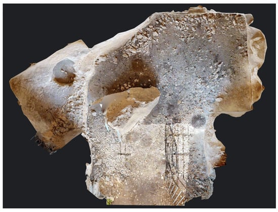
Figure 1.
Pantalica, church of San Nicolicchio. Dollhouse view obtained through scans carried out with the Matterport Pro3 (Matterport Inc., Sunnyvale, CA, USA).
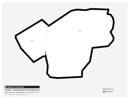
Figure 2.
Pantalica, church of San Nicolicchio, layout with plan extracted from the model, obtained through scans carried out with the Matterport Pro3.
The irregular layout is likely the result of the reuse and transformation of a pre-existing nucleus than of alterations undertaken during the execution of the original project. This hypothesis is supported by an examination of the decorative remains on the curvilinear wall segment—a sort of rock-cut pillar–separating the small northwest recess from the apse-ended chamber. Three painted panels are visible on its surface, each containing full-length images of saints, in critical conservation condition (Figure 3) [33,34,35,36,38,41].
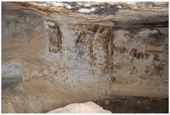
Figure 3.
Pantalica, Church of San Nicolicchio, view of the north wall.
The first panel on the left shows a saint, now missing his head, who can be identified as a military saint in ceremonial attire by details such as the green tablion (the panel on the front of the cloak) and the sword at his side. To the right, a panel of similar size depicts Saint Helen with a pearled halo, wearing circular earrings and holding her identifying attributes: the True Cross and the crown (Figure 4). Next to Saint Helen, a panel depicts the Protomartyr and Deacon Stephen, already identified as such by Orsi [33,42] (Figure 5). His Greek name can still be read in the panel’s background. Above the panel, a three-line Greek votive inscription mentions Eraclia, likely the patron, who invokes the saint’s protection for herself and her children (Figure 6). Although a 12th-century attribution has been proposed in scholarly debate [34], stylistic features, notably the strongly graphic treatment of the drapery, supported by comparisons with early medieval examples in Syracuse [43], Rome, and Southern Italy, post-iconoclastic Cappadocian decoration [44], and 11th-century Greek frescoes, suggest a dating between the 9th and 11th centuries [35,36]. The various elements considered suggest that the Church of San Nicolicchio may have absorbed a pre-existing cult space that was probably decorated in the pre-Norman period. It is plausible that this space was then reconfigured as an apsidal, orientated church. The small dimensions (which are unsuitable for communal liturgical use), the presence of a Greek votive inscription above the panel depicting Saint Stephen and the stylistic features of the preserved paintings all suggest that the first nucleus of the church was created as a private initiative for funerary purposes, likely between the 9th and 11th century [35,36].
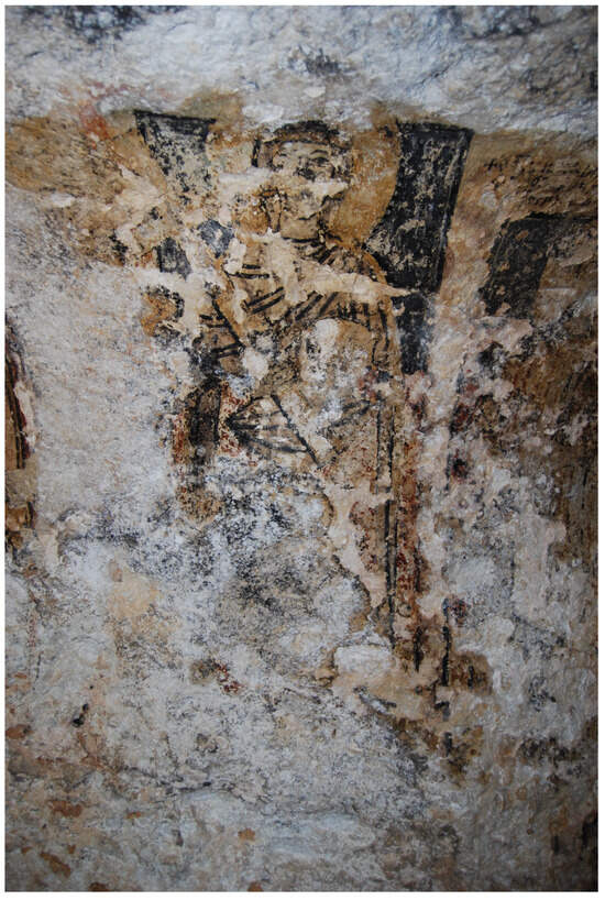
Figure 4.
Pantalica, Church of San Nicolicchio, Saint Helen.
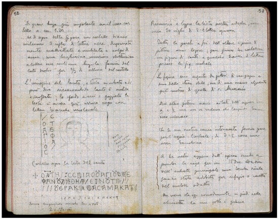
Figure 5.
Notes and hand-drawn sketch of Saint Stephen by Paolo Orsi. Syracuse, Archaeological Museum ‘Paolo Orsi’, Taccuini di Paolo Orsi, notebook 28, 1895, pp. 52–53. Reproduced by permission of the Regione Siciliana—Assessorato dei Beni Culturali e dell’Identità Siciliana. Further reproduction prohibited.
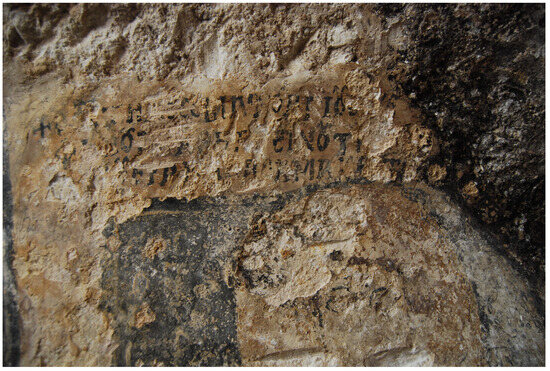
Figure 6.
Pantalica, Church of San Nicolicchio, panel with Saint Stephen and the votive inscription above, detail.
Given the church’s small scale, irregular layout, and fragile pictorial surfaces, 3D scanning technologies provide an effective tool for documentation and analysis, overcoming challenges of visibility and physical access. The navigable 3D model accurately preserves the spatial configuration, volumetry, and painted surfaces in their original context, creating a lasting digital archive for visual documentation and monitoring of conservation conditions. Beyond research purposes, the immersive model opens the site to both specialists and the general public, thereby promoting engagement, shared memory, and collaborative interpretation. [G.A.]
3.1.6. Church of the Crocifisso
The so-called Church of the Crocifisso [32,33,35,36,37,38] is located on the slope separating the site from the village of Sortino (Figure 7), at the end of the path leading from the mill to the large quarry and onward to the northern necropolis. Partially underground and open to the east, the church consists of two adjacent but offset chambers (Figure 8). The northern chamber contains a rectangular niche that likely functioned as an apse. According to Robert Leighton, the church may have reused “an older domestic chamber of the kind abundantly represented in this part of the site” [45].
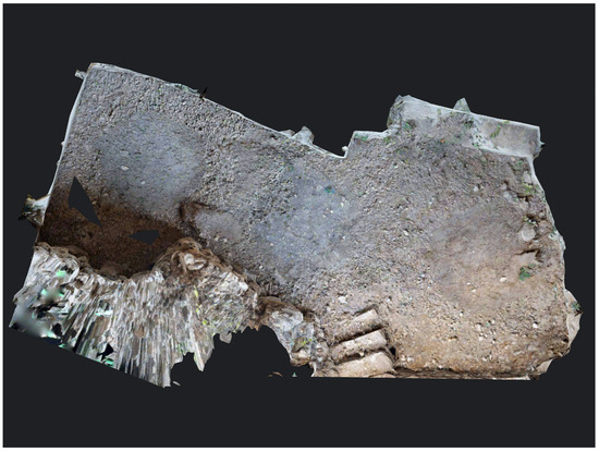
Figure 7.
Pantalica, Church of the Crocifisso, dollhouse view obtained through scans carried out with the Matterport Pro3.
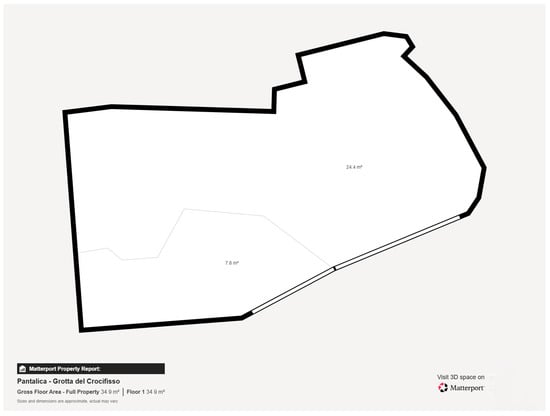
Figure 8.
Pantalica, Church of the Crocifisso, layout with plan extracted from the model, obtained through scans carried out with the Matterport Pro3.
On the southern wall facing the entrance, a panel displays a frontal standing image of Saint Nicholas with his characteristic iconography (Figure 9). This panel can be dated to the 14th century, as proposed by Orsi [33] and supported by the surviving Latin inscription (NICOLAUS). Faint traces preserved on the northern wall, at the back of the rectangular cut, belong to a Crucifixion, likely from the same phase as the Saint Nicholas panel (Figure 10). These fragmentary remains can likewise be attributed to the 14th century, as suggested by comparisons with other late medieval Crucifixion examples preserved in the rock-cut churches of the Hyblean territory [35,36].
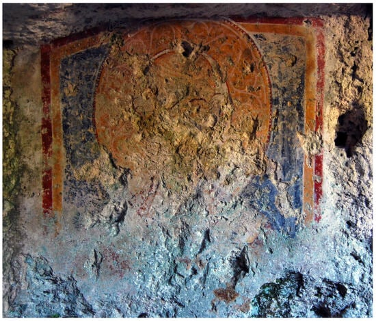
Figure 9.
Pantalica, Church of the Crocifisso, south wall, St Nicholas.
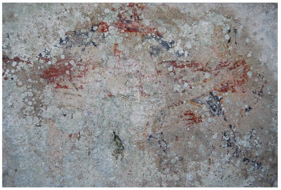
Figure 10.
Pantalica, Church of the Crocifisso, north wall, remains of the Crucifixion, detail.
The head of a female saint, which Orsi observed on the wall opposite the entrance in 1895 [42] can be attributed to an earlier phase (Figure 11). The painting was removed from the church’s wall and transferred to the Archeological Museum of Syracuse, where it was certainly located in 1947 [46]. It depicts the face and part of the bust of a saint in a frontal position. She is dressed in a dark red cloak and wears small hoop earrings. Her reddish-brown hair is gathered under a transparent veil that wraps around her neck and falls on either side of her face. A pearly halo dotted with circular red elements that resemble precious stones surrounds her head. In the absence of specific attributes or inscriptions, the identity of the figure remains uncertain. However, based on the iconographic features, the saint could be one of the martyrs venerated in Sicily, such as Saint Barbara [37], Saint Agatha, Saint Parasceve or Saint Lucy. The painting clearly draws on XII centuries byzantine canons, transmitted locally through the mosaics of the Norman royal foundations. However, the fleshy and pictorial rendering of the face, as well as the decorative elements, and comparisons with examples of rock art from Sicily and Southern Italy from the early to mid-13th century suggest an early 13th-century date [35,36].
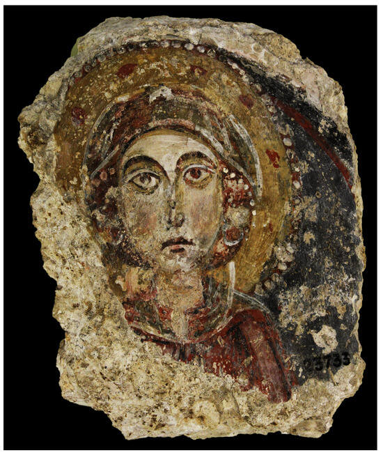
Figure 11.
Syracuse Archeological Museum “Paolo Orsi”, fresco fragment depicting the head of a female saint, detached from the Church of the Crocifisso (inv. 23733).
Since 2018, the fragment has been on display in the new section of the “Paolo Orsi Museum” dedicated to Christian Syracuse [47]. To reconstruct the original appearance of the ‘Crocifisso’ church, the fresco fragment is planned to undergo laser scanning and to be integrated into the finalized virtual model. The possibility of reconnecting objects now housed in museums—such as removed frescoes, liturgical furnishings, sculptures, lighting devices, etc.—to their original context represents one of the potential applications of the IT technologies developed by the SPOKE 6 project team to enhance and study selected sites of interest. This approach offers significant value in terms of documenting, preserving and accurately interpreting artifacts and spaces, as well as developing strategies to improve their presentation and accessibility within museum settings. [G.A.]
3.1.7. Pantalica’s Rock-Cut Churches: Research and New Perspectives from Historical to Digital Memory
The digitization of Pantalica rock-cut churches serves several critical, interlinked purposes, aligning with the objectives of CHANGES Spoke 6 for cultural heritage management: conservation (both as memory and physical safeguarding), restoration planning, and broad, inclusive sharing of results.
These new approaches–rooted in the dialogue between humanities and sciences—belong to a broader historical, theoretical and epistemological framework that involves the crucial issue of the potential and risk of reproducibility of works of art, as well as the concept of the “vicarious” image as a mirror and interpretative tool of reality [48].
In this sense, the 3D model of the churches of San Nicolicchio and the Crocifisso, selected as case studies within a wider investigation of stratified landscapes, continues a knowledge trajectory that begins with the erudite writings of the sixteenth and seventeenth centuries, proceeds through the pioneering studies carried out by Paolo Orsi, and extends into contemporary research. Within this heuristic process, digital surveying does not merely document the present state of an object, but generates a dynamic archive for research, conservation and knowledge-sharing purposes.
Digital surveying is primarily used to archive and preserve the visual documentation of reconstructed spaces. Unlike traditional methods, it provides highly accurate and repeatable measurements, as well as continuous updates to metric data and survey records. The navigable 3D model provides an interactive experience, enabling a “virtual” autoptic investigation of the rock-cut’s constituent elements and their respective functions. Its accessibility to both scholars and the general public therefore aligns with research and enhancement objectives [49,50,51]. As a dynamic surrogate of the original object, the three-dimensional model can also be used to monitor pictorial surfaces and structural supports over time, providing a basis for planning urgent restoration work or digital restoration projects [52,53].
In summary, the digital documentation of the churches of Pantalica defines new modes of narrating cultural heritage. It helps to reframe the research questions, allowing for testing hypotheses on phasing and functions specific to the site’s irregular layout, fragile painted surfaces, and epigraphic elements. The immersive experience offered by the 3D model generates new forms of shared memory through active engagement, transforming users into protagonists of the perceptual and cognitive process.
More generally, virtual restitution of images and objects to their places of origin, enabled by digital remediation, can be considered both a historical and a trans-historical operation. On the one hand, it restores visual content no longer accessible to direct perception, re-establishing the chain of interactions between physical and mental images that pictorial representation once generated for a specific audience in a specific historical moment; on the other, it contemporizes that content, situating it within the experiential horizon of new audiences. Within this multidisciplinary framework, rooted in an expanded concept of accessibility, new technologies project into the future the results of a knowledge process shaped over time, «bridging past and present in the life of images» [54]. [G.A.]
3.2. Haghia Triada
3.2.1. New Perspectives on Multi-Storey Protohistoric Architecture: The Case of Minoan Palatial Buildings
Developing a comprehensive workflow that fully exploits the potential of the digital revolution while preserving methodological rigor is particularly urgent when dealing with early architectural traditions, which are fragile and poorly preserved. This is especially true for prehistoric and protohistoric constructions, to the point that they have been referred to in scholarly literature as “neglected artifacts” [55]. Several factors explain this: firstly, the absence of written sources means these cultures are known exclusively through archeology, leaving interpretation either to archeologists with limited architectural training or to architects less familiar with archeological methodology. The fragmentary state of the remains further hinders research: gaps are rarely addressed, and missing portions are rarely reconstructed, leading to analyses focused solely on preserved ground plans, while the three-dimensional aspect of the building–essential for its function–remains ignored. The negative impact of this approach increases with architectural complexity. It is less critical for simple, single-storey buildings but becomes a major limitation when dealing with complex, multi-level structures. Although rare, multi-storey systems are attested in prehistoric and protohistoric contexts, reaching remarkable sophistication in the Aegean during the Bronze Age (3rd–2nd millennium BCE). On Crete, this trend culminated in the so-called Minoan Palatial period, marked by monumental multi-storey buildings with intricate socio-economic functions [56,57,58,59].
In this context, the paucity of data—due to poor preservation (largely from the use of perishable materials), early excavation methods, and the scarcity of direct sources–contrasts with the complexity and heterogeneity of the buildings, especially those of the Neopalatial period (1750–1490 BCE), characterized by highly articulated multi-level layouts. As a result, Minoan architecture studies have long faced a challenging research environment, where the fragility of evidence exposed any reconstruction attempt to criticism of arbitrariness. These critiques were exacerbated by the lack of a shared, rigorous methodology—a long-standing problem in the study of protohistoric architecture. It is not unlikely that, in formulating the concept of the effet-projet [60]—the risk that the restorer, in reconstructing ancient architecture, identifies with the creator–Pierre Gros also had in mind Evans’s restorations at Knossos. It is therefore understandable that scholars have often approached Minoan architectural reconstruction with caution, or avoided it altogether. This explains why, in public dissemination, one still finds outdated reconstructions or artist’s impressions with limited grounding in archeological evidence [61]. [D.P.]
3.2.2. Graphic Reconstruction and Virtual Restoration: Applications to Minoan Architectural Practice
An ongoing study on the history of graphic reconstructions of Minoan architecture [62] has yielded significant insights. A survey of some 150 scientific publications (manuals, excavation reports, and specialized papers) shows that, prior to the digital era (1905–1994), fewer than one-third of published reconstructions depicted elevations through sections, axonometric drawings, or perspectives; this figure drops to about 4.5% when considering only complete building reconstructions, excluding single-room or detail views. Predictably, the three subsequent decades (1995–2024) not only saw an exponential increase in published reconstructions—nearly double the number in a third of the time—but also a higher proportion of full-elevation drawings, now exceeding 6%. Strikingly, between 2005 and 2014 sections, axonometrics, and perspectives together accounted for almost half of all published reconstructions. This growth reflects both increased scholarly production and the wider availability of digital design, modeling, and rendering tools.
Most virtual reconstructions, however, have focused on domestic or funerary contexts [63], or on exceptionally well-preserved buildings that allow for relatively complete architectural studies—such as the still-ongoing work at Akrotiri on Thera [57,64], which, while informative, lies outside Crete and must be cautiously compared. The major palatial sites remain more problematic. Knossos alone accounts for nearly half of all cretan elevation reconstructions—three times more than the next most represented site, Mallia—yet most are dated and limited to small portions of the building. For the palaces as a whole, despite their centrality in Minoan studies, there is a near-total absence of attempts to reconstruct overall elevations and volumetric articulation2 [65]. When such drawings exist, they typically show only the building overall volumetric form [56] and lack systematic argumentation supporting the proposed reconstruction. Even at smaller scales, such as the so-called “villas”, volumetric reconstructions remain opaque, rarely indicating the evidence base or reasoning behind design choices—the familiar “black box” effect.
This situation underscores the urgent need to update reconstruction methodologies for Minoan architecture. Rigorous reconstructions require first a systematic collection and organization of documentation, using the full range of modern tools: GNSS, GIS, photogrammetry, and laser scanning now ensure excellent records for recent excavations. Yet most major monuments were excavated before these techniques were available, often more than a century ago, resulting in the permanent loss of stratigraphic data and leaving graphic documentation incomplete, outdated, or unreliable. Any project aiming to bring Minoan palatial architecture into the realm of Virtual Heritage must therefore begin by renewing documentation through integrated GNSS, photogrammetry, laser scanning, and autoptic analysis to create a reliable digital replica. This must be complemented by a thorough reexamination of stratigraphy, architecture, and archival excavation records. Only on such foundations can we produce scientifically robust 3D reconstructions, applying methodologies such as semantic approaches and visual scaling for reliability, and then disseminate them through the rapidly expanding array of Virtual and Augmented Reality platforms. [M.C.]
3.2.3. Haghia Triada in Late Minoan IB: An Ideal Case for IT Experimentation
Haghia Triada is one of the most representative, well-known, and complex multi-phase settlements of Crete (Figure 12). Occupied continuously throughout the Bronze Age (3rd–2nd millennium BCE), it also saw limited reoccupation during the Hellenistic and Roman periods [66].
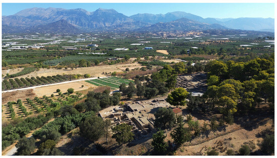
Figure 12.
Haghia Triada: Aerial view of the archeological site from the southwest.
Excavated between 1902 and 1914 by the Italian Archeological Mission in Crete, and later investigated stratigraphically by the Italian Archeological School at Athens and the University of Catania (1977–1999, 2006–2012) [66], the site (Figure 13) reached its architectural peak in the Neopalatial period, particularly in its final phase, conventionally labeled Late Minoan I (from now on LM I, 16th-early 15th BCE) [67,68]. This phase saw the construction of the so-called Villa Reale, a monumental multi-storey complex laid out in an L-shaped plan along the north and west slopes of the hill of S. Giorgio Galata, covering roughly 1900 m2 (Figure 14). In size and monumentality, the building is comparable to a Minoan palace, differing mainly in its lack of a central court.
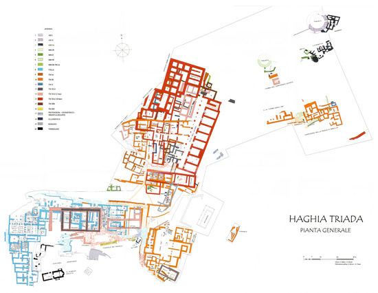
Figure 13.
Multi-phase plan of the stratified settlement. In light blue (bottom-left) the structures of the Villa Reale (da Creta Antica: 4, 2003).
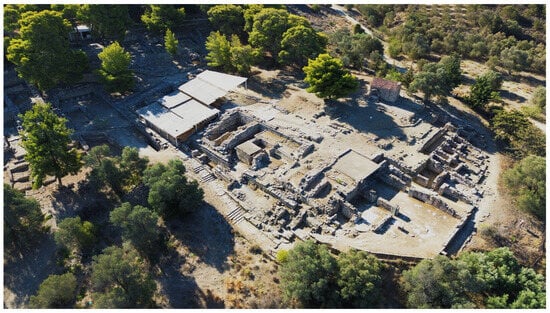
Figure 14.
Aerial view of the Villa Reale from the northwest.
For several reasons, the LM IB architectural remains offer an ideal context to test new IT applications in Minoan architecture. More than a century of archeological research–only partly published–provides a rich documentary base of finds and stratigraphic data. This allows relatively precise chronological definition and contextual reconstruction, but also poses major challenges for data storage and management given the heterogeneity of sources: early excavation notebooks, unpublished diaries, publications of different types, photographic archives, plans, and artifacts. Moreover, the structures were fully surveyed but through traditional methods and at variable scales, amplifying the limits of two-dimensional representation and the margin of error.
This situation calls for renewed documentation using digital techniques capable of overcoming earlier shortcomings while preserving their communicative and informational value—especially for structures later dismantled or altered by restoration.
Finally, the LM IB remains are exceptionally well preserved compared with other Minoan sites, partly because the buildings were constructed on a natural slope with a multi-level arrangement. This favored both their survival to considerable heights and the possibility of reconstructing floor levels and floor-to-floor heights with unusual precision. In other words, Haghia Triada provides a rare opportunity to infer the original placement of upper stories, a task far more difficult in settlements on flat terrain. These circumstances make the site particularly suited to virtual restoration, which can recover its lost three-dimensionality while addressing the crucial issues of reliability and transparency inherent in any reconstructive endeavor. [D.P.]
4. Results and Future Perspectives
4.1. Pantalica
4.1.1. Acquisition Methodology: The Application of Matterport Pro3 to the Churches of San Nicolicchio and the Crocifisso at Pantalica
Digital archeology has increasingly relied on advanced 3D technologies to enhance documentation, interpretation, and dissemination of cultural heritage. Beyond traditional surveying methods, the integration of digital platforms enables the creation of immersive reconstructions and interactive models that expand both scholarly analysis and public engagement [69,70,71,72]. Laser scanning has emerged as a powerful tool for documenting and monitoring hypogeal or rupestrian contexts, yet its effectiveness often depends on balancing precision with portability. In this regard, the Matterport Pro3 represents a new generation of devices that combine LiDAR accuracy with accessible workflows, making it particularly suitable for cultural heritage and confined spaces. As literature highlight, the integration of advanced 3D surveying techniques into heritage studies not only enhances documentation but also broadens opportunities for analysis and dissemination.
Matterport Pro3 is Matterport’s first 3D LiDAR camera, designed to quickly scan indoor and outdoor spaces. Matterport’s free app (Figure 15) guides data acquisition, minimizing human error and allowing the extraction of floor plans, point clouds, BIM files, and other technical documents necessary for digital documentation.
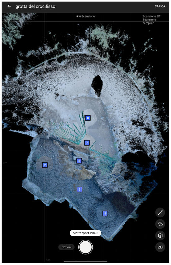
Figure 15.
Mobile visualization of the point cloud derived from the scans acquired with the Matterport Pro3 inside the Church of the Crocifisso. The image shows the spatial distribution of the points and the locations of individual scan positions.
The Matterport Pro3 includes a high-density scanning mode, currently available as a software option, which can capture over 5 million distance points per scan [73] In standard scanning modes, the number of points captured per scan is lower. The collected data can be exported in E57 format, which can be used in design software such as Autodesk Revit for BIM modeling. Matterport Pro3 combines LiDAR scanning with mesh models to generate accurate three-dimensional documentation of existing structures, including technical areas and environments that are difficult to reach or illuminate, such as underground ones. These models enable detailed virtual inspections and support planning, maintenance, and restoration activities.
Matterport Pro3 demonstrates robust performance in complex and low-light environments primarily due to its active depth-sensing technology, which does not rely on ambient illumination for geometric data acquisition. This capability, combined with high-quality RGB imaging and automated exposure control, enables the system to capture reliable spatial and visual information even in poorly lit or completely dark contexts. Furthermore, internal image processing pipelines and HDR optimization improve image balance and contrast, enhancing overall clarity and interpretability of the resulting models, which is particularly advantageous in confined or visually challenging environments such as subterranean or archeological spaces. The good performance of Matterport in complex and low-light environments is largely attributable to its integrated LiDAR-based active depth-sensing system. LiDAR operates independently of ambient lighting conditions, as it actively emits laser pulses to measure distances, ensuring reliable geometric acquisition even in complete darkness. This LiDAR-derived spatial framework is then combined with high-quality RGB imagery acquired through automated exposure control and HDR processing. While RGB data primarily contribute to texture and visual interpretation, the LiDAR component provides accurate and stable geometry, making the overall system particularly effective in challenging environments where passive optical methods alone would be insufficient.
The technical specifications of the Matterport Pro3 clarify its suitability for surveying complex and confined archeological contexts. The device is based on LiDAR depth-sensing technology, using a Class 1 laser in accordance with IEC 60825-1:2014 [74] with a wavelength of 904 nm and a field of view of 360° horizontally and 295° vertically. It provides a nominal measurement accuracy of ±20 mm at 10 m, a minimum operating range of approximately 0.5 m, and a maximum range of up to 100 m. The system captures depth data at a rate of about 100,000 points per second, producing roughly 1.5 million points per scan, with automatic registration of successive scans. Imaging capabilities include high-resolution panoramic outputs of 134.2 megapixels generated through HDR acquisition with five exposures per frame and automatic white balance. Each scan requires less than 20 s, while the camera boot time is under 40 s, supporting efficient fieldwork. Data acquisition and remote control are managed through the Matterport Capture App on iOS or Android devices, with wireless communication via BLE and 5 GHz Wi-Fi. From a hardware perspective, the camera has compact dimensions (181 × 161.4 × 76 mm), a weight of approximately 2.2 kg, and an integrated GPS module. Power is supplied by a battery capable of more than 220 continuous scans, with charging times of about 2.5 h to reach 80% and 3.5 h for a full charge. The Pro3 is designed for practical field conditions, operating reliably between 0 °C and 40 °C, with an IP43 ingress protection rating, making it robust enough for use in underground and rupestrian environments [75].
In addition, Matterport provides an online web-based platform that allows users to access, manage, and edit their processed models through an intuitive interface. Once the cloud processing is completed, the resulting models are immediately available in a ready-to-use format, enabling basic editing operations, navigation, annotation, measurements, and sharing directly within the platform, without the need for external software or access to raw data (Figure 16). Importantly, Matterport does not provide direct access to the raw point cloud during the standard workflow: all scans are processed in the cloud to produce a ready-to-use project. For this reason, the actual point cloud, its effective quality in archeological conditions, and metrics for comparison with other instruments are not provided by the manufacturer and should be described through independent measurements or drawn from the academic literature when available.
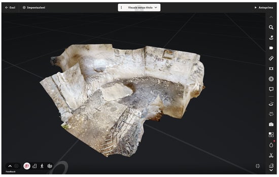
Figure 16.
Dollhouse view of the Church of San Nicolicchio 3D model seen through the Matterport web app. The service provides an overall spatial reconstruction of the environment, processed through the proprietary cloud-based workflow.
The documentation and study of rock-cut architectural environments present unique challenges due to limited accessibility, irregular geometries, and variable lighting conditions. Traditional survey methods are often insufficient to capture the intricate details of these spaces, making high-precision digital technologies indispensable.
Within this complex scenario, the Matterport Pro3 3D scanner was selected as the primary instrument for our investigation. This choice was driven by its combination of LiDAR-based geometric accuracy, high-resolution RGB imaging, and portability, which collectively enable the efficient acquisition of detailed spatial and visual data even in constrained and obstructed areas [76]. By employing this system, it is possible to generate reliable point clouds, textured mesh models, and immersive virtual environments that support conservation, restoration planning, and broader accessibility of cultural heritage. The use of Matterport Pro3 thus represents a methodological cornerstone for addressing the specific demands of hypogeal architecture, ensuring that both the spatial complexity and the historical value of these environments are accurately preserved in digital form. Raw data are processed in the Matterport Cloud, producing textured meshes and immersive navigable models. These assets serve multiple purposes: metric reference for geometric and stratigraphic analyses, degradation mapping, and planning of conservation or restoration. The data can also be exported to BIM environments, enabling semantic enrichment and supporting advanced heritage management. This workflow is instrumental for the creation of Digital Twins, dynamic replicas that allow temporal monitoring and comprehensive conservation strategies.
The core technical functionality rests on the LiDAR system, which actively measures distances by emitting laser impulses that capture highly precise geometric data from surrounding surfaces with millimeter accuracy. Concurrently, the high-resolution RGB imaging system captures detailed visual information necessary for generating realistic textures that enrich the 3D models. The fundamental output produced by the scanning process is a meticulously detailed point cloud, which serves as a metrologically reliable dataset for subsequent analysis and conservation studies.
Crucially, the Matterport Pro3 is designed with internal software capable of automatically aligning multiple scans. This software identifies common spatial features across individual acquisitions and unifies them into a coherent 3D coordinate system, thereby generating real-time previews and significantly optimizing efficiency, especially in complex environments where illumination and accessibility are major limiting factors. The device’s inherent portability is a key feature that makes it invaluable for documenting spaces with restricted visibility or physical access, such as subterranean or tightly clustered areas.
The workflow continues post-acquisition as the raw data is uploaded to the Matterport Cloud platform for computational processing. This cloud environment is responsible for generating several final digital assets: textured mesh models (polygonal representations enriched with RGB visual data) and immersive navigable digital environments. The cloud platform also offers essential functionalities such as rapid visual inspection, and comprehensive workflows for tagging and annotation, enabling the semantic linkage of spatial elements with diagnostic or stratigraphic data. These linked data can be displayed as interactive pop-up information within the Matterport environment, allowing users to access detailed contextual information directly while navigating the 3D model — a feature particularly valuable for advanced restoration and archeological analysis. Furthermore, the point clouds generated through this process can be exported and integrated directly into Building Information Modeling (BIM) environments, facilitating the semantic enrichment of the 3D models and supporting sophisticated heritage management protocols. This streamlined process is instrumental in the creation of Digital Twins—dynamic, data-enriched replicas that enable temporal monitoring of changes and support comprehensive conservation strategies. The resulting digital models are optimized for interactive virtual tours accessible via standard web browsers and Extended Reality (XR) devices. [S.B.,F.S.]
4.1.2. Assessing the Performance and Reliability of the Matterport Pro3 System
The detailed digitization of San Nicolicchio and the Crocifisso rock-cut churches was carried out with the Matterport Pro3. LiDAR ensured precise geometric capture, while RGB imaging provided visual detail. The resulting point clouds and mesh models updated existing metric data and supported the documentation of complex layouts. The use of the Matterport Pro3 demonstrated clear operational benefits for the documentation of the rock-cut churches of Pantalica, particularly in terms of acquisition speed, portability, and automated alignment, all crucial aspects in narrow, low-light environments. The integration of LiDAR measurements with high–resolution RGB imagery enables the generation of immersive models suitable for architectural interpretation, conservation monitoring, and public dissemination. A key parameter for assessing the reliability of the 3D dataset is the device’s metric accuracy, estimated at at a distance of [75] This means that any point recorded at 10 m may deviate within a range of 2 cm, resulting in real-world distances falling between and . Such precision is more than adequate for architectural documentation of small environment and conservation planning, ensuring a faithful geometric representation of the cavities.
Despite these advantages, the system presents inherent limitations. The accuracy of , while suitable for most heritage documentation tasks, remains lower than that of high-end terrestrial laser scanners, limiting the device’s applicability for analyses requiring sub-centimetric detail, such as micro–deformation studies, fracture monitoring, or stratigraphic micro–mapping. Furthermore, the proprietary cloud–based processing pipeline reduces user control over alignment parameters, filtering operations, and mesh reconstruction, affecting reproducibility and inter–comparability with datasets produced by other instruments. Automated mesh generation may also introduce interpolation artifacts, visually smoothing surfaces at the expense of metrological fidelity. Finally, restricted access to calibration procedures and registration settings complicates systematic error assessment and the implementation of advanced validation protocols, underscoring the need for complementary high–precision datasets in contexts where metric rigor is paramount.
Although the Matterport-based workflow provides an exhaustive descriptive record, its real contribution emerges only when this documentation is critically interpreted. The 3D dataset allows for analytical reflections on the spatial logic, phasing, and functional transformations of the rock-cut churches, supporting a broader archeological and epistemological discourse. For instance, the spatial relationships between the carved chambers, the differential visibility of painted surfaces, and the morphological constraints of the cavities inform hypotheses about liturgical circulation, the reuse of earlier spaces, and the diachronic evolution of ritual practices. Similarly, the ability to integrate historical photographs, archival information, and material traces within the digital model transforms the survey from a mere recording exercise into a platform for hypothesis testing, versioning, and scholarly verification.
Digital documentation should not be confined to descriptive purposes but must be embedded within a structured analytical framework that interrogates evidence, uncertainty, and the epistemic implications of reconstruction choices. Although the workflow guarantees a solid level of visual and geometric documentation, the lack of explicit validation metrics remains a significant limitation, especially given the closed nature of the Matterport ecosystem, which restricts access to detailed alignment and calibration parameters. Future developments will therefore focus on validation strategies compatible with these constraints.
On the quantitative side, basic comparative checks with independently acquired datasets will help assess general geometric consistency and identify potential deviations or coverage gaps. Qualitatively, attention will be directed toward understanding how sensor accuracy, automated processing, and lighting conditions may influence the reliability of interpretive outcomes. Strengthening these validation steps will improve transparency and reproducibility, ensuring that subsequent interpretive models are supported by a more robust methodological framework. Digital models serve as archival references, allow monitoring of fragile painted surfaces, and enable comparative analyses for mapping degradation (pigment loss, chromatic alterations, biological activity). Their portability and automated alignment make them effective even in irregular, low-light contexts.
The detailed 3D digitization of these confined rock-cut spaces was specifically executed using the Matterport Pro3 3D scanner due to his capability of generating precise digital replicas of complex architectural settings. The primary output of this rigorous acquisition is a detailed point cloud. This point cloud constitutes a metrologically reliable dataset essential for subsequent geometric analysis and the creation of polygonal mesh models. The resulting dataset is instrumental for documenting complex planivolumetric arrangements of the cavities and effectively updating the available metric data and surveys. [S.B., F.S.]
4.1.3. Processing, Conservation Monitoring, and Digital Restoration
Once acquired, the raw data are uploaded to the Matterport Cloud platform for computational processing. This cloud environment is responsible for generating the final digital assets, including textured mesh models (polygonal representations enriched with visual data) and immersive navigable digital environments (Figure 17). The generated virtual model fulfills crucial conservation and interpretive functions:
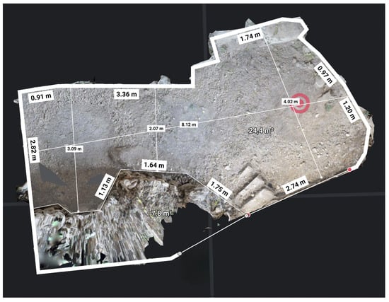
Figure 17.
Measurements taken from a floor plan derived from a LiDAR scan using the Matterport Pro3 system of the Church of the Crocifisso.
- Archival and Preservation. It ensures the archiving and conservation of the visual memory of the environment.
- Macro-Scale Monitoring. The 3D model provides a metric and spatial reference, capturing the current state of structural and painted elements. While it does not achieve sub-millimeter precision for pigment or chromatic analysis, it allows comparisons over time of macro-scale variations and visible surface changes. This information supports the evaluation of risk status and the formulation of sustainable safeguarding strategies.
- Conservation Support. The cloud platform further facilitates the tagging and annotation workflow, linking spatial elements to diagnostic analysis. The integration of annotations and stratigraphic or diagnostic data can support digital restoration and the planning of urgent conservative interventions.
- Research and Public Engagement. The 3D model allows scholars to test interpretive hypotheses regarding spatial relationships, phasing of use over time, pictorial remnants, or functional transformations. It further supports comparative investigations across sites, contributing to broader typological and historical studies of rupestrian heritage. Tags and annotation workflows provide detailed information on iconography, chronology, and object description, making the 3D model a resource for both scholars and the general public.
- Virtual Recontextualization. The digital model supports the process of digital remediation by allowing the virtual reconnection of musealized objects to their original context. For example, a 3D scan of the “head of a saint” fragment, currently displayed at the Paolo Orsi Museum, is intended for virtual recontextualization back into the Church of the Crocifisso, based on historical and archival sources.
- Interactive Access and shared memory. The three-dimensional model acts as a dynamic copy of the original object, permitting interactive access independent of spatial or geographic limitations and ensuring accessibility for various audiences.
Interdisciplinary collaboration among archeologists, art historians, architects, and IT specialists, combined with the integration of traditional archeological methods and advanced information technologies, is essential for the knowledge, protection, and enhancement of cultural heritage, especially in complex, layered contexts. Tools like the Matterport Pro3, with LiDAR precision and portability, are optimally suited for the high-resolution documentation of confined spaces such as Pantalica’s rock-cut churches, supporting conservation in a broad sense. At the same time, the need for transparency in the reconstruction process, particularly evident in multi-story architectures like Haghia Triada, drives the adoption of rigorous methodologies such as Extended Matrix and ArchaeoBIM. The combination of precise digital acquisition and semantic enrichment of 3D models is key to a scientifically founded and accessible Virtual Heritage, projecting research results toward new developments. [G.A, S.B, F.S.]
4.2. Haghia Triada: The Digital Restoration of a Protohistoric Multistory Building
4.2.1. Three-Dimensional Modeling at Haghia Triada
Between 2018 and 2021, a team of architects led by an archeologist participated in the HTR 3D project, aimed at analytically studying the Haghia Triada ruins in order to reconstruct the settlement’s three-dimensional appearance before its destruction in the LM IB phase [77,78]. The initial goal was to produce a plausible reconstruction emphasizing the original volumetry of the structures, without critically addressing the reliability of hypothetical integrations and focusing instead on the graphical rendering of the modeled forms. An initial, realistic-looking model (Figure 18) was later replaced by a second, more accurate reconstruction, deliberately simplified in its visual style to highlight its hypothetical nature, ensure overall legibility, and avoid any “picturesque” effect (Figure 19).
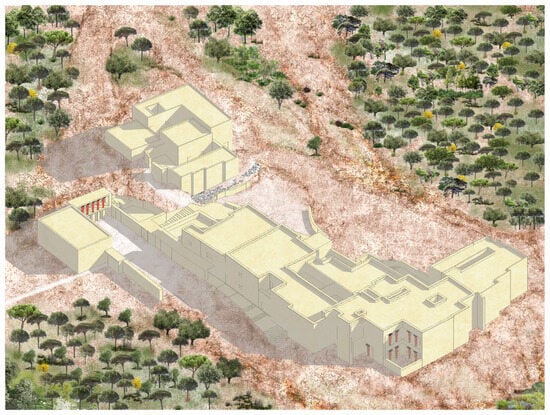
Figure 18.
Realistic rendering of Model 1.0 of the Villa Reale, viewed from the northwest.
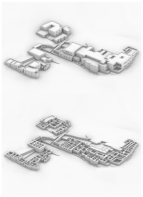
Figure 19.
Graphically simplified Model 2.0 of the Villa Reale, viewed from the northwest. Top: volumetric rendering of the building of the settlement. Bottom: axonometric section showing the ground floors.
The 3D modeling process soon revealed an intrinsic hermeneutic potential, generating questions and allowing insights—particularly concerning the organization of upper floors—that could not be achieved through conventional 2D analysis alone. The resulting model was thus not merely a depiction of a lost original, but a reconstruction of a partially known architectural system whose digital manipulation enabled a better understanding of the relationships between preserved and missing elements. It therefore functioned as a powerful tool for formulating and testing hypotheses and advancing knowledge of structures no longer recoverable in situ.
From 2023 onward, research at Haghia Triada continued under the CHANGES project. The first field data revisions, focused primarily on the monument’s altimetry, prompted a critical review of the 2018–2021 models. Several earlier reconstructions were corrected or discarded, and a new version was produced, concentrating on the Villa Reale and the adjacent Piazzale Superiore and Piazzale Inferiore (Figure 20). This process also led to a methodological reflection on the iterative nature of virtual reconstruction: while the capacity of a model to generate new hypotheses is a major strength, frequent updates risk creating confusion. To address this, a versioning system inspired by software development was introduced, distinguishing major releases (e.g., 3.0) from minor revisions (e.g., 3.1). Up to this stage, the construction of the three-dimensional model relied primarily on traditional archeological documentation and legacy data.
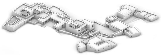
Figure 20.
Model 3.1: The most complete and reliable representation of the Villa Reale to date, viewed from the southeast. Compared to the previous models, a more articulate volumetry and the presence of architectural details, as gutters, porches and pergolas, can be noted.
These included the general plans of the monument produced during the first excavation campaign (1902–1914), the analytical drawings from the second campaign (1977–1999; 2006–2012), and the excavators’ notebooks recording annotations, sketches, and interpretative remarks. This information was refined and supplemented through new field observations focusing on altimetry and the general stratigraphy of the structures.
Because most of the available documentation was two-dimensional, the initial modeling phase employed widely used architectural drawing and modeling software—AutoCAD R25.0 (San Francisco, CA, USA) for 2D drafting and Rhinoceros for 3D modeling. Their combined use ensured strict dimensional control, allowing the model to correspond closely with the archeological evidence. This process is particularly delicate in the case of Minoan architecture, where upper floors—often accounting for half of a building’s total volume—are the least preserved. To mitigate the inherent risk of arbitrariness, a methodological framework was established for hypothesizing their presence and arrangement, informed among other things by parallels with the exceptionally well-preserved site of Akrotiri on Thera [57]. The presence of upper floors was also assessed following the indicators proposed by Michailidou [79] (stairs, load-bearing elements, collapsed materials, objects fallen from above), integrated with structural considerations and with the terraced configuration of the Villa, which provides additional contextual clues. Where the documentation offered no secure basis for reconstruction, provisional solutions were proposed by analogy with other Neopalatial monumental buildings, fully acknowledging their conjectural nature. Transparency was ensured by providing a clear textual justification for each hypothesis [80]. The use of Rhinoceros allowed for a clean, non-photorealistic volumetric visualization, deliberately emphasizing the interpretive and analytical character of the model as a research tool.
This iterative 3D modeling process significantly improved the understanding of the spatial organization of the Villa’s upper floors—an essential step before broader dissemination. The most complete and reliable representation to date, model 3.1, restores for the first time the building’s full three-dimensional identity (Figure 20). The Villa covered c. 3500 m2 of built space, roughly half on the upper floor (for a total volume exceeding 12,000 m3), plus c. 3000 m2 of open areas. Access points were few and functionally differentiated: monumental and courtyard-mediated for ceremonial sectors, simple and external for storage and service areas. Internal organization shows clear functional zoning, alternating storage areas and ceremonial quarters, with circulation systems designed to control and monumentalize movement. Large halls on the upper floor likely hosted ceremonies, while the ground floor was structured primarily to support these spaces. Overall, the Villa appears as a major communal building designed for two principal activities: restricted ceremonial events and the storage and management of goods.
These insights provide the narrative framework for both scholarly interpretation and public dissemination in a future synchronic exhibition dedicated to the LM I phase of the settlement. As a first step, simple immersive videos have been produced to replicate the perceptual experience of navigating the Villa’s intricate spatial layout. Future work will refine these with photorealistic rendering to enhance credibility and visitor engagement. Additionally, using model 2.1, a 1:200 scale 3D print of the Villa was produced and displayed at the exhibition “Nell’isola di Dedalo” (Catania, June 2023), marking the 25th anniversary of the University of Catania’s Centro di Archeologia Cretese (Figure 21). Although based primarily on traditional archeological documentation, the updated model represents the most plausible reconstruction of the Villa Reale’s configuration at the time of its destruction, insofar as this is supported by the available evidence. However, the tool presented three main limitations. First, its highly pragmatic and site-specific methodology–designed to address the particular problems posed by this case study–requires further development and abstraction to be applicable to other contexts. In addition, the software employed are not open source, which makes the method more difficult to disseminate and replicate. Finally, it did not explicitly document the data or reasoning underlying individual reconstruction choices: the analytical processing of sources occurred prior to modeling and remained disconnected from the virtual representation, producing a clear “black box” effect that obscured the interpretive steps linking archeological evidence to the final digital model. [D.P.]
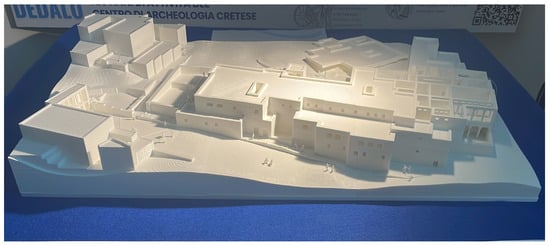
Figure 21.
3D print of Model 2.1 on display at the exhibition “Nell’isola di Dedalo” (Catania, June 2023).
4.2.2. New Data Survey at Haghia Triada
The experiments discussed so far, though offering numerous applications for both research and public outreach, still do not address a key issue: the lack of communication between the virtual reconstruction model and the hypothetical–deductive reasoning that guided its creation. This is a crucial point, as much of the credibility we have proposed to assign to 3D modeling at Haghia Triada depends on it. Without an integrated system that makes its conjectural basis explicit, the model risks remaining a mere graphical representation, dependent on an accompanying written text to explain its reconstructive logic step by step. This limitation is, moreover, widespread across all existing reconstructions of Minoan architecture.
Given the particularly favourable conditions of the case study, it was considered that Haghia Triada could serve as a paradigmatic example for adopting the most up-to-date methodologies, employing IT tools not only for data acquisition, management, and processing, but–crucially—for enhancing the value and communicability of the resulting interpretations. In fact, the system would take a significant step forward if it became a three-dimensional “container” for the data and arguments supporting the reconstruction itself. Among the experiments conducted on our case study, this is the one we consider most significant, both for its innovative nature and for its potential applicability to the rest of Minoan palatial architecture—particularly for its ability to document the entire reconstructive process and to highlight the varying levels of reliability of each component of the virtual reconstruction.
In short, the overarching goal is to establish a fully transparent, data-driven reconstructive workflow that can be replicated across Minoan architectural contexts. On this basis, a new and extensive project was launched in 2024 to make Haghia Triada the first Minoan site equipped with a reconstruction that complies with the metadata and paradata transparency criteria promoted by the London Charter, with particular attention to upper floors and their reconstructive process. The project is currently underway, and the present contribution will limit itself to describing the work in progress and the results expected.
The first step in the workflow involved acquiring a new, detailed three-dimensional dataset which, once integrated with the legacy data, would serve as the primary source for the new 3D model. This was achieved through a series of field campaigns carried out in 2024, combining direct observations with a comprehensive digital survey of the surviving structures. Given the size of the site, work focused on the Villa Reale, while the rest of the settlement was left for future campaigns. The survey was conducted by F. Buscemi, G. D’Agostino and M. Chiricallo using a combination of different tools and methodologies.
A first complete and accurate aerial photogrammetric survey, undertaken under the direction of F. Buscemi in the preceding years, is currently in press [81]. For practical purposes, a second photogrammetric acquisition was carried out using a DJI Mini 2 drone, a highly agile and easily manoeuvrable UAV suitable for low-altitude, manually piloted flights, enabling the documentation of narrow or confined spaces. The resulting dataset—consisting of 2551 photographs–allowed the production of a fully operational photogrammetric model of the entire Villa (Figure 22). With its good architectural-scale resolution (GSD of 7.13 mm/pixel) and a mean error of 0.027 m on the topographic GCP (Ground Control Points), this model can already be employed for a range of analytical purposes.
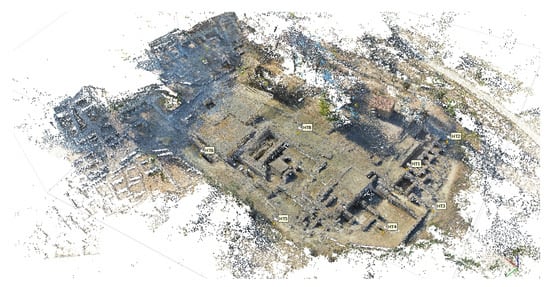
Figure 22.
Point cloud derived from the aerial photogrammetric survey of the Villa Reale by M. Chiricallo, showing the GCP used for scaling and georeferencing, viewed from the northwest.
At the same time, starting from the western half of the monument, a higher-resolution survey was initiated by G. D’Agostino3, integrating terrestrial photogrammetry and laser scanning using a Leica BLK360 (Leica Geosystems AG, Heerbrugg, Switzerland). This methodology proved particularly effective in the areas of the Villa covered by protective roofs–where drone flights are not feasible–and is essential for obtaining the high-quality data required for wall stratigraphy analysis and, potentially, for VR/AR applications aimed at virtual visits to the monument in its present state. Convinced that instrumental surveying cannot fully replace traditional architectural drawing—whose interpretive nature is expressed through hierarchically structured graphic signs–plans and sections extracted from the new dataset were used as a base for producing a new set of analytical two-dimensional drawings of the Villa (plans and sections at 1:50 scale). These were made by M. Chiricallo directly on site, through manual drawing on an iPad, after visual inspection and dimensional verification of the represented structures. Meanwhile, a new mapping of the Villa’s architectural stratigraphic units is underway, completing the analysis of the extant structures.
The results of this extensive data-acquisition process will finally be systematized within a GIS environment, together with all legacy data and previous graphic documentation. The outcome will be a complete and well-organized starting dataset, easily integrable into different 3D reconstruction workflows and potentially made available to the scholarly community. Precise and multi-layered survey data are indispensable for a reconstruction workflow where every interpretive step must be explicitly anchored to spatially referenced evidence. [M.C.]
4.2.3. New Data Processing at Haghia Triada
In parallel with the construction of the new dataset, several solutions are being explored to translate the reconstructive process into a transparent system capable of producing photorealistic outputs when required, while rigorously documenting their underlying metadata and paradata. The system should also remain open to future integration with virtual-reality or augmented-reality applications. At present, the most promising strategy is the adoption of the Extended Matrix (EM) methodology. The construction of the EM model of the Villa is still in its initial stages and can therefore only be outlined in methodological terms, emphasizing the reasons that suggest its strong potential and suitability for application in the Minoan context.
The advantages of applying EM to the reconstruction of Minoan architecture are considerable. All tools within the Extended Matrix Framework are fully open access, and online platforms already exist to share results with the scholarly community and to support, in the future, collaborative reconstruction projects involving researchers with different expertise. Moreover, constructing the proxy model—an analytically structured, simplified replica of the site’s current condition–greatly improves data management. Each Stratigraphic Unit (US), modeled individually, can be linked to attributes such as chronology, construction technique, or state of preservation, all visualizable directly within the 3D space. These units may also be attached to field documentation (US forms, photographs, notes). Particularly important for Minoan studies is the possibility of incorporating Documentary Stratigraphic Units based on archival records of features no longer visible today—a frequent situation given the heavy post-excavation alteration affecting many Minoan sites. These documentary units can similarly be linked to their archival sources and to the reasoning supporting their proposed reconstruction.
In this way, the proxy model becomes the core of a three-dimensional archive, conceptually comparable—though with certain limitations–to 3D GIS or HBIM systems. EM’s real added value, however, lies in its ability to document in detail the reasoning that leads from the extant evidence to the reconstructed model. Through the introduction of Virtual Stratigraphic Units (USV), defined as hypothetical reconstructions of no-longer-extant units [18], the method allows one to justify each reconstructive choice, propose alternatives, and highlight uncertainties. USVs may be structural (USV/S), grounded in identifiable lacunae, or non-structural (USV/N), based solely on indirect evidence, analogies, or archival sources.
This distinction provides an initial measure of reliability. Yet the structural criterion is often too restrictive for Minoan architecture, where upper storeys–typically built with perishable materials–rarely leave identifiable negative stratigraphic traces. As a result, almost all upper-storey hypotheses fall into the USV/N category, making it difficult to differentiate between reconstructions of very different reliability. For example, a ceiling in a room certainly once roofed and a set of horns of consecration placed above an entrance might both be USV/N, despite representing very different degrees of certainty. The risk is that the reconstructed model collapses visually into an undifferentiated mass of non-structural units, limiting the expressive potential of the tool.
Current work therefore explores solutions such as assigning confidence levels to each USV/N, in order to express degrees of plausibility and make them visually legible. The flexibility of EM suggests promising prospects in this direction: for instance, a “reliability” level could be assigned as a property to each USV and displayed directly in the proxy model. Several graphical reliability scales proposed in recent years have been examined, each emphasizing different methodological issues. The visual scale designed by Aparicio-Resco and Figueiredo [15] places strong emphasis on documentary evidence–both graphic and textual–but is unsuitable for Minoan architecture, which lacks contemporary written sources and nearly all later accounts prior to excavation. Similar considerations make the adaptation used by Bassoli, Fallavollita, and Fuchs for the theatre of Urbs Salvia [17] more appropriate than the scale proposed by Apollonio [16]: the latter includes references to textual sources relevant to classical and post-antique contexts but irrelevant to protohistoric ones, whereas the former relies exclusively on archeological and architectural-historical criteria.
A further, original approach is also under evaluation. Highly pragmatic in nature, it assesses data quality for architectural reconstruction through three properties: existence, extent (i.e., position and dimensions), and shape. Each of these can be evaluated as certain, hypothetical, or arbitrary. Cross-referencing the parameters yields a five-level reliability scale for reconstructed structures (plus one for preserved elements). These levels can be assigned to USVs within an EM model and visualized through a false-colour scale (Figure 23). A first experiment on Portico 10 at Haghia Triada—an autonomous and suitably small structure for preliminary testing–shows that this scale offers significantly greater granularity than the EM stratigraphic-node classification, without compromising stratigraphic rigour (Figure 24). Further testing is underway and, if the method proves robust, it will be presented in more analytical detail in the future. In any case, a stratigraphic reconstruction model closely tied to its metadata and paradata, and open to critical review, would already represent a major step forward in the study of Minoan architecture. Additional progress may come from integrating EM with the ArchaeoBIM approach, which in many respects is complementary. Both systems enable systematic storage and connection of the data underpinning reconstruction, supporting iterative testing and refinement toward plausible, evidence-based solutions. This is especially significant given the Minoan context, where the loss of upper structures and the intrinsically low standardization of architectural forms make certainty unattainable.
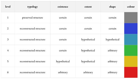
Figure 23.
Proposed work-in-progress scale of the reliability levels, based on three practical 3D properties: existence, extent and shape.
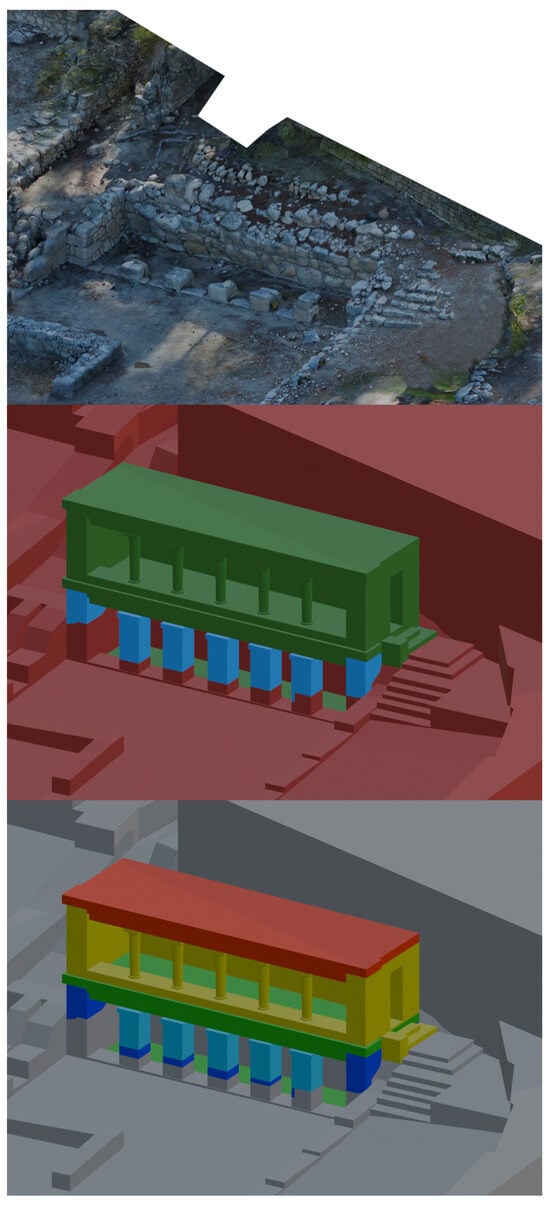
Figure 24.
The Portico 10 at Haghia Triada. Top: reality based model derived from the aerial photogrammetry. Center: proxy-model in false colours, based on the Extended Matrix nodes (US = red; USV/s = blue; USV/n = green). Bottom: proxy-model in false colours, based on the proposed reliability scale.
A reconstruction model rich in data and reasoning—yet explicit about its limits—is likely the most meaningful outcome achievable. From such a robust foundation, further applications (photorealistic renders, VR/AR experiences, or even narrative or game-based environments) can be developed. Future work will also ensure full compliance with FAIR data-management principles [11], particularly regarding versioning, provenance tracking, and repository-based accessibility. However, these outputs must be grounded in a transparent and methodologically rigorous core model. The ongoing EM-based reconstruction of the Villa Reale at Haghia Triada aims to establish precisely such a paradigm, encouraging broader adoption of virtual-restoration principles in the study of Minoan, and more generally prehistoric and protohistoric, architectural contexts preserved only as ruins. [M.C.]
5. Conclusions
In Pantalica, where architecture survives as carved voids marked by extreme spatial constraints and delicate painted surfaces, the Matterport Pro3 proves particularly effective: its portability, rapid acquisition, and integrated LiDAR–RGB system make it possible to document complex rupestrian spaces with a level of precision and accessibility unattainable through traditional methods. The process of recontextualization is more than a simple visual reunification; it represents a significant methodological shift by leveraging the 3D model as an interactive, hypothesis-testing environment that formally links dispersed material evidence to its original, layered spatial context. This capability transforms the survey from a static record into a dynamic heuristic tool.
The 3D model is thus elevated from the role of a mere static archival document to that of an interactive virtual laboratory and hypothesis-testing environment. This digital platform allows for the formalization of connections between dispersed material evidence and its layered original spatial context, enabling the archeologist to formulate and quantitatively test different hypotheses regarding the position, orientation, and contextual association of a fragment. This capability is crucial for archeological reasoning in highly fragmented contexts, as it transforms the investigation from a purely descriptive account into a dynamic heuristic tool capable of generating new knowledge and supporting interpretation. In terms of implications for digital practice, utilizing the model as a testing environment helps to make interpretations not only more visible but, crucially, more transparent and verifiable, an essential requirement for establishing new standards in heritage documentation and digital reconstruction.
Conversely, at Haghia Triada, the challenge lies not in recording surviving structures but in reconstructing what has been lost—entire upper floors, circulation systems, and volumetric configurations that once shaped the experience of the site. Here, digital workflows combining photogrammetry and laser scanning provide the technical foundation for formulating and revising hypotheses, while emerging semantic approaches—such as the Extended Matrix—represent a promising avenue for future developments.
Taken together, these examples highlight the methodological versatility required to address the heterogeneous conditions of ruined architecture. They show that no single digital tool or workflow can be universally applied; rather, the strength of IT strategies lies in their adaptability to different preservation states, spatial morphologies, and interpretive needs. The integration of acquisition technologies with more transparent reconstructive procedures offers a shared ground for future work, while semantic modeling will, in time, contribute additional layers of interpretive clarity. Ultimately, the comparison underscores a broader principle: digital practices achieve their highest potential when they respond to the material and conceptual specificity of archeological contexts, turning fragmentary remains—whether carved into rock or standing on terraced slopes—into dynamic, intelligible, and critically interpretable heritage resources.
Author Contributions
Conceptualization, S.P.B., G.A., M.C. and D.P.; methodology, S.P.B., G.A., M.C. and D.P.; validation, D.P. and F.S.; investigation, G.A.,M.C., D.P.; resources, G.A., D.P.; data curation, S.P.B., M.C.; writing—original draft preparation, S.P.B., G.A., M.C., D.P. and F.S.; writing—review and editing, S.P.B.; supervision, F.S. All authors have read and agreed to the published version of the manuscript.
Funding
The research has been supported by MUR in the framework of PNRR Mission 4, Component 2, Investment 1.3 under project CHANGES, Spoke 6 (CUP E63C22001960006). The project is funded by the European Union—NextGenerationEU under the National Recovery and Resilience Plan (PNRR)—Mission 4 Education and research—Component 2 From research to business—Investment 1.3, Notice D.D. 341 of 15/03/2022, entitled: Cu: PE0000020—CUPJ33C22002850006.
Data Availability Statement
The data presented in this study are available on request from the corresponding author.
Acknowledgments
This work is the result of a collaborative effort made possible through the convergence of interdisciplinary expertise within the CHANGES foundation. The integration of technological, archeological, and diagnostic approaches exemplifies the shared objectives of CHANGES Spoke 6: to develop innovative tools and methodologies for the interpretation and sustainable management of complex cultural heritage contexts. The authors wish to express their sincere gratitude to the Centro di Archeologia Cretese of the University of Catania and the Italian Archeological School of Athens (Scuola Archeologica Italiana di Atene) for granting the necessary authorization to conduct the research and for their invaluable support during its execution. The reproductions of artifacts and documents (Figure 5 and Figure 10), belonging to the Paolo Orsi Regional Archeological Museum (Syracuse), are published with the permission of S. 39—‘Parco Archeologico e Paesaggistico di Siracusa, Eloro, Villa del Tellaro e Akrai’. Further reproduction or duplication in any form is prohibited. The research has been supported by MUR in the framework of PNRR Mission 4, Component 2, Investment 1.3 under project CHANGES, Spoke 6 (CUP E63C22001960006).
Conflicts of Interest
The authors declare no conflicts of interest.
Notes
| 1 | For a brief overview about the earlier development of VR technologies for cultural heritage, see [7]. |
| 2 | An exception is the so-called palace of Gournia: see [65]. |
| 3 | This part of the work is still under development and will be presented separately. |
References
- Ronchi, D.; Limongiello, M.; Demetrescu, E.; Ferdani, D. Multispectral UAV Data and GPR Survey for Archaeology: Anomaly Detection Supporting 3D Reconstruction. Sensors 2023, 23, 2769. [Google Scholar] [CrossRef]
- Touati, A.-M.L.; Staub, T.; Forsell, R. From 2D and 3D Documentation to 4D Interpretation: Building Archaeological Conclusions and Workflow Strategies Gained by Remote Study of Insula V 1, Pompeii. Opuscula 2021, 14, 181–226. [Google Scholar] [CrossRef]
- Caliò, L.M.; Fino, A.; Gerogiannis, G. MLS con sensore LiDAR Apple per lo scavo archeologico: Applicazioni pratiche. In Proceedings of the MeTe Digital: Mediterranean Networks Between Texts and Contexts (AIUCD 2024), Catania, Italy, 28–30 May 2024. [Google Scholar]
- Demetrescu, E.; Ferdani, D. From Field Archaeology to Virtual Reconstruction: A Five Steps Method Using the Extended Matrix. Appl. Sci. 2021, 11, 5206. [Google Scholar] [CrossRef]
- Demetrescu, E.; Fanini, B.; Cocca, E. An Online Dissemination Workflow for the Scientific Process in CH through Semantic 3D: EMtools and EMviq Open Source Tools. Heritage 2023, 6, 1264–1276. [Google Scholar] [CrossRef]
- Barceló, J.A. Virtual Reality for Archaeological Explanation. Beyond “Picturesque” Reconstruction. Archeologia e Calcolatori 2001, 12, 221–244. [Google Scholar]
- Sanders, D. A Brief History of Virtual Heritage. In Picturing the Past: Imaging and Imagining the Ancient Middle East; Institute for the Study of Ancient Cultures: Chicago, IL, USA, 2012. [Google Scholar]
- Münster, S.; Apollonio, F.I.; Bluemel, I.; Fallavollita, F.; Foschi, R.; Grellert, M.; Ioannides, M.; Jahn, P.H.; Kurdiovsky, R.; Kuroczyński, P.; et al. (Eds.) Handbook of Digital 3D Reconstruction of Historical Architecture; Springer: Cham, Switzerland, 2024. [Google Scholar]
- Denard, H. A New Introduction to the London Charter. In Paradata and Transparency in Virtual Heritage; Bentkowska-Kafel, A., Denard, H., Baker, D., Eds.; Farnham: Surrey, UK, 2012; pp. 57–71. [Google Scholar]
- Doerr, M. The CIDOC Conceptual Reference Model: An Ontological Approach to Semantic Interoperability of Metadata. AI Mag. 2003, 24, 75–92. [Google Scholar]
- Wilkinson, M.D.; Dumontier, M.; Aalbersberg, I.J.; Appleton, G.; Axton, M.; Baak, A.; Blomberg, N.; Boiten, J.W.; da Silva Santos, L.B.; Bourne, P.E.; et al. The FAIR Guiding Principles for Scientific Data Management and Stewardship. Sci. Data 2016, 3, 160018. [Google Scholar] [CrossRef]
- Yang, X.; Lu, Y.-C.; Murtiyoso, A.; Koehl, M.; Grussenmeyer, P. HBIM Modeling from the Surface Mesh and Its Extended Capability of Knowledge Representation. ISPRS Int. J. Geo-Inf. 2019, 8, 301. [Google Scholar] [CrossRef]
- Messaoudi, Y.; Véron, P.; Halin, G. A Semantic-Based Approach for the Interpretation and 3D Reconstruction of Building Archaeology Data. Comput.-Aided Des. Appl. 2018, 15, 239–249. [Google Scholar]
- Guillem, A.; Ruymbeke, M.V.; Eide, Ø.; Luca, L.D. Spatio-Temporal Reasoning on Stratigraphic Data in Archaeology: Formalization of the Harris Laws as Inferences Using CIDOC CRM. In Proceedings of the SWODCH’24—4th International Workshop on Semantic Web and Ontology Design for Cultural Heritage, Tours, France, 30–31 October 2024. [Google Scholar]
- Aparicio-Resco, P.; Figueiredo, C. El grado de evidencia histórico-arqueológica de las reconstrucciones virtuales: Hacia una escala de representación gráfica. Revista Otarq Otras Arqueologías 2016, 235. [Google Scholar] [CrossRef]
- Apollonio, F.I. Classification Schemes and Model Validation of 3D Digital Reconstruction Processes. In Proceedings of the 20th International Conference CHNT, Vienna, Austria, 16–18 November 2016. [Google Scholar]
- Bassoli, I.; Fallavollita, F.; Fuchs, W. Hypothesis of Reconstruction of the Roman Theater of Urbs Salvia. SCIRES-it 2022, 12, 151–164. [Google Scholar]
- Demetrescu, E. Archaeological Stratigraphy as a Formal Language for Virtual Reconstruction: Theory and Practice. J. Archaeol. Sci. 2015, 57, 42–55. [Google Scholar] [CrossRef]
- Demetrescu, E.; Fanini, B. A White-Box Framework to Oversee Archaeological Virtual Reconstruction in Space and Time: Methods and Tools. J. Archaeol. Sci. Rep. 2017, 14, 500–514. [Google Scholar] [CrossRef]
- Fanini, B.; Ferdani, D.; Demetrescu, E.; Berto, S.; D’Annibale, E. ATON: An Open-Source Framework for Creating Immersive, Collaborative and Liquid Web-Apps for Cultural Heritage. Appl. Sci. 2021, 11, 11062. [Google Scholar] [CrossRef]
- Berto, S.; Cocca, E.; Demetrescu, E. Extended Matrix Manager: An Open Tool for EM-Based Knowledge Graphs Management. Archeologia e Calcolatori 2024, 35, 167–176. [Google Scholar]
- Mancuso, G. ArcheoBIM ed Extended Matrix. Analisi e potenzialità di due processi per l’elaborazione di modelli informativi. Archeologia e Calcolatori 2023, 34, 123–142. [Google Scholar]
- Garagnani, S.; Gaiani, M.; Gaucci, A.; Moscati, P. ArchaeoBIM. Theory, Processes and Digital Methodologies for the Lost Heritage; Bononia University Press: Bologna, Italy, 2021. [Google Scholar]
- Liu, J.; Willkens, D.; López, C.; Cortés-Meseguer, L.; García-Valldecabres, J.L.; Escudero, P.A.; Alathamneh, S. Comparative Analysis of Point Clouds Acquired from a TLS Survey and a 3D Virtual Tour for HBIM Development. Int. Arch. Photogramm. Remote Sens. Spat. Inf. Sci. 2023, XLVIII-M-2-2023, 959–968. [Google Scholar] [CrossRef]
- Hutson, J.; Weber, J.; Russo, A. Digital Twins and Cultural Heritage Preservation: A Case Study of Best Practices and Reproducibility in Chiesa dei SS Apostoli e Biagio. Art Des. Rev. 2023, 11, 15–41. [Google Scholar] [CrossRef]
- Chen, W.; Shimoda, I. Enhancing the Interpretation of Industrial Heritage and Cultural Landscape of Iwami Ginzan through Digital Technologies. Int. Arch. Photogramm. Remote Sens. Spat. Inf. Sci. 2025, XLVIII-M-9-2025, 225–232. [Google Scholar] [CrossRef]
- Syracuse, Archaeological Museum “Paolo Orsi”, P. Orsi, Taccuini di Paolo Orsi, notebook 3. 1889. Available online: https://www.parcoarcheologicosiracusa.it/taccuino-3/ (accessed on 21 January 2026).
- Orsi, P. I taccuini, 1: Riproduzione anastatica e trascrizione dei taccuini 1-4; Lamagna, G., Monterosso, G., Eds.; L’Erma di Bretschneider Roma, Italy, 2018. [Google Scholar]
- Arcidiacono, G. Dalla ricerca sul campo alle nuove tecnologie digitali: Conoscenza, tutela e valorizzazione della pittura medievale rupestre in Sicilia. In Ipogei 4.0. I paesaggi rupestri dell’Italia meridionale tra ricerca, innovazione e gestione del patrimonio culturale, Atti del convegno, Mottola, Italy, 26–27 May 2023; D’Auria, C., Giorgi, M.D., Eds.; Posa Edizioni: Mottola, Italy, 2024; pp. 85–113. [Google Scholar]
- Arcifa, L. Pantalica altomedievale: Per una nuova stagione delle ricerche. In Pantalica e la Sicilia nelle età di Pantalica, Atti del convegno, Sortino (Syracuse), Italy, 15–16 December 2017; Blancato, M., Militello, P., Palermo, D., Panvini, R., Eds.; Creta Antica; Bottega d’Erasmo: Padova, Italy, 2019; pp. 177–201. [Google Scholar]
- Militello, P.; Castagnino, E.F. L’anaktoron di Pantalica: Le indagini 2017 (con appendice di Viola Lentini). In Pantalica e la Sicilia nelle età di Pantalica, Atti del convegno, Sortino (Syracuse), Italy, 15–16 December 2017; Blancato, M., Militello, P., Palermo, D., Panvini, R., Eds.; Creta Antica; Bottega d’Erasmo: Padova, Italy, 2019; pp. 117–143. [Google Scholar]
- Orsi, P. Sicilia Bizantina; Agnello, G., Ed.; Arti grafiche A. Chicca: Tivoli, Italy, 1942. [Google Scholar]
- Orsi, P. Chiese bizantine nel territorio di Siracusa. Byzantinische Zeitschrift 1898, VII, 1–28. [Google Scholar] [CrossRef][Green Version]
- Messina, A. Le chiese rupestri del Val di Noto; Istituto Siciliano di Studi Bizantini e Neoellenici: Palermo, Italy, 1994. [Google Scholar]
- Arcidiacono, G. Le ultime fasi di Pantalica: Le chiese rupestri e la loro decorazione pittorica. In Pantalica e la Sicilia nelle età di Pantalica, Atti del convegno, Sortino (Syracuse), Italy, 15–16 December 2017; Blancato, M., Militello, P., Palermo, D., Panvini, R., Eds.; Creta Antica; Bottega d’Erasmo: Padova, Italy, 2019; pp. 203–228. [Google Scholar]
- Arcidiacono, G. Pittura medievale rupestre in Sicilia. Il territorio di Siracusa tra Oriente e Occidente; Centro Italiano di Studi sull’Alto Medioevo–CISAM: Spoleto, Italy, 2020. [Google Scholar]
- Messina, A. Le chiese rupestri del Siracusano; Istituto Siciliano di Studi Bizantini e Neoellenici: Palermo, Italy, 1979. [Google Scholar]
- Giglio, S. La cultura rupestre di età storica in Sicilia e a Malta: I luoghi del culto; Lussografica: Caltanissetta, Italy, 2002. [Google Scholar]
- Rizzone, V.G.; Sammito, A.M. Le chiese rupestri nel contesto dell’insediamento. In Insediamenti rupestri di età medievale: Abitazioni e strutture produttive. Italia centrale e meridionale, Atti del Convegno di studi, Grottaferrata, Italy, 27–29 October 2005; De Minicis, E., Ed.; Centro Italiano di Studi sull’Alto Medioevo–CISAM: Spoleto, Italy, 2008; Volume I, pp. 103–128. [Google Scholar]
- Rizzone, V.G.; Sammito, A.M. Per una definizione dello sviluppo delle chiese rupestri del Val di Noto: Articolazione planivolumetrica e relazioni con l’insediamento. In Insediamenti rupestri di età medievale nell’Italia centrale e meridionale: L’organizzazione dello spazio nella mappatura dell’abitato. Proceedings of the II Atti del Convegno nazionale di Studi, Vasanello, Italy, 24–25 October 2009; De Minicis, E., Ed.; Kappa: Roma, Italy, 2011; pp. 147–162. [Google Scholar]
- Agnello, G. Le arti figurative nella Sicilia bizantina; Istituto Siciliano di Studi Bizantini e Neoellenici: Palermo, Italy, 1962. [Google Scholar]
- Syracuse, Archaeological Museum “Paolo Orsi”, P. Orsi, Taccuini di Paolo Orsi, notebook 28. 1895, pp. 52–53. Available online: https://www.parcoarcheologicosiracusa.it/category/taccuini/ (accessed on 21 January 2026).
- Peers, G. Finding Faith Underground: Visions of the Forty Martyrs Oratory at Syracuse. In Looking Beyond: Visions, Dreams, and Insights in Medieval Art and History; Hourihan, C., Ed.; Princeton: Princeton, NJ, USA, 2010; pp. 84–106. [Google Scholar]
- Jolivet-Lévy, C. L’arte della Cappadocia; Jaca Book: Milano, Italy, 2001. (In Italian) [Google Scholar]
- Leighton, R. Pantalica (Sicily) from the Late Bronze Age to the Middle Ages: A New Survey and Interpretation of the Rock-Cut Monuments. Am. J. Archaeol. 2011, 115, 447–464. [Google Scholar] [CrossRef][Green Version]
- Agnello, S.L. Il riordinamento del materiale cristiano bizantino del Museo Archeologico di Siracusa. Nuovo Didask. 1947, I, 81–87. [Google Scholar]
- Musumeci, M. (Ed.) Il Cristianesimo a Siracusa e nel territorio; Regione Siciliana, Assessorato dei Beni Culturali e dell’Identità Siciliana, Dipartimento dei Beni Culturali e dell’Identità Siciliana: Palermo, Italy, 2023. [Google Scholar]
- Andaloro, M.; Pogliani, P. Fotografare come “specchio”. L’Università della Tuscia nella Caria e nella Cappadocia bizantina. In Fotografare Bisanzio. Arte bizantina e dell’Oriente mediterraneo negli archivi italiani, Atti della XVII Giornata di Studi dell’Associazione Italiana di Studi Bizantini, Roma, Italy, 15–16 October 2021; Iacobini, A., Bevilacqua, L., Eds.; Campisano Editore: Roma, Italy, 2022; pp. 179–202. [Google Scholar]
- Mendoza, M.A.D.; Franco, E.D.l.; Gómez, J.E.G. Technologies for the Preservation of Cultural Heritage. A Systematic Review of the Literature. Sustainability 2023, 15, 1059. [Google Scholar] [CrossRef]
- Olivito, R.; Taccola, E.; Albertini, N. Cultural Heritage and Digital Technologies: Theory, Methods and Tools for the Study and Dissemination of Knowledge in the Archaeological Practice. In Digital Methods and Remote Sensing in Archaeology—Archaeology in the Age of Sensing; Forte, M., Campana, S., Eds.; Springer: Cham, Switzerland, 2016; pp. 475–494. [Google Scholar]
- Boboc, R.G.; Băutu, E.; Gîrbacia, F.; Popovici, N.; Popovici, D.-M. Augmented Reality in Cultural Heritage: An Overview of the Last Decade of Applications. Appl. Sci. 2022, 12, 9859. [Google Scholar] [CrossRef]
- Masciotta, M.G.; Morais, M.J.; Ramos, L.F.; Oliveira, D.V.; Sanchez-Aparicio, L.J.; Gonzalez-Aguilera, D. A Digital-Based Integrated Methodology for the Preventive Conservation of Cultural Heritage: The Experience of the HeritageCare Project. Int. J. Archit. Herit. 2021, 15, 844–863. [Google Scholar] [CrossRef]
- Limoncelli, M.; Potenza, F. Virtual Restoration, 2. The Frescoes of the Rock-Cut Church of Lama d’Antico near Fasano (Italy); L’Erma di Bretschneider: Roma, Italy, 2020. [Google Scholar]
- Belting, H. Image, Medium, Body: A New Approach to Iconology. Crit. Inq. 2005, 31, 302–319. [Google Scholar] [CrossRef]
- Sanders, D. Architecture: The Neglected Artifact. In Problems in Greek Prehistory; French, E.B., Wardle, K.A., Eds.; Bristol Classical Press: Bristol, UK, 1988; pp. 489–498. [Google Scholar]
- Graham, J.W. The Palaces of Crete; Princeton: Princeton, NJ, USA, 1962. [Google Scholar]
- Palyvou, C. Akrotiri, Thera: An Architecture of Affluence 3,500 Years Old; Casemate Group: Philadelphia, PA, USA, 2005. [Google Scholar]
- McEnroe, J.C. Architecture of Minoan Crete: Constructing Identity in the Aegean Bronze Age; University of Texas Press: Austin, TX, USA, 2010. [Google Scholar]
- Shaw, J.W. Elite Minoan Architecture: Its Development at Knossos, Phaistos and Mallia; INSTAP: Philadelphia, PA, USA, 2015. [Google Scholar]
- Gros, P. La restitution monumentale en architecture romaine: Quelques problèmes de méthode. Revue Archéologique 1985, 1, 177–185. [Google Scholar]
- Alušík, T.; Chalupka, M.; Kopernicky, D. 3D Virtual Reconstructions of Minoan Rural Sites: The Case of Livari Cheromylia (East Crete). Int. Arch. Photogramm. Remote Sens. Spat. Inf. Sci. 2011, XXXVIII-5, 537–544. [Google Scholar]
- Chiricallo, M. L’architettura minoica nella sua tridimensionalità: Per una verifica scientifica della sua immagine. Ph.D. Thesis, University of Bari (PASAP_Med), Bari, Italy. in progress.
- Alušík, T.; Sovarova, D. The Accuracy Requirements and Sources for 3D Reconstructions of the Prehistoric Archaeological Sites: The Case of Agios Antonios Chomatas (Crete). Int. Arch. Photogramm. Remote Sens. Spat. Inf. Sci. 2015, XL-5, 437–444. [Google Scholar] [CrossRef]
- Palyvou, C. Akrotiri, Thera: The Architecture of the West House; Melissa Publishing House: Athens, Greece, 2019. [Google Scholar]
- Soles, J.S. The Gournia Palace. Am. J. Archaeol. 1991, 95, 17–78. [Google Scholar] [CrossRef]
- Rosa, V.L. “Il colle sul quale sorge la chiesa ad Ovest è tutto seminato di cocci…” Haghia Triada: Vicende e temi di uno scavo di lungo corso. Creta Antica 2003, 4, 11–68. [Google Scholar]
- Halbherr, F.; Stefani, E.; Banti, L. Haghia Triada nel periodo tardo-palaziale. ASAtene 1977, 55, 7–296. [Google Scholar]
- Puglisi, D. Haghia Triada nel periodo Tardo Minoico I. Creta Antica 2003, 4, 145–198. [Google Scholar]
- Barbagallo, S.P.; Stanco, F.; Tanasi, D. Modeling memory: Ethical reuse and AI training with archaeologist-produced 3D reconstructions. In Proceedings of the 2025 IMEKO TC26 International Conference on Metrology for Archaeology and Cultural Heritage, Bergamo, Italy, 15–17 October 2025. [Google Scholar]
- Shults, R.; Levin, E.; Habibi, R.; Shenoy, S.; Honcheruk, O.; Hart, T.; An, Z. Capability of Matterport 3D Camera for Industrial Archaeology Sites Inventory. Int. Arch. Photogramm. Remote Sens. Spat. Inf. Sci. 2019, XLII-2/W11, 1059–1064. [Google Scholar] [CrossRef]
- Stanco, F.; Tanasi, D.; Allegra, D.; Milotta, F.L.M. 3D Digital Imaging for Knowledge Dissemination of Greek Archaic Statuary; STAG: St Albans, UK, 2016; pp. 133–141. [Google Scholar]
- Tanasi, D. The Digital (Within) Archaeology: Analysis of a Phenomenon. Historian 2020, 82, 22–36. [Google Scholar] [CrossRef]
- Matterport. Matterport Adds Scanning Mode for Pro3 Scanner that Captures High-Density, High-Resolution Point Clouds. Available online: https://matterport.com/news/matterport-adds-scanning-mode-for-pro3-scanner-that-captures-high-density (accessed on 15 November 2025).
- International Electrotechnical Commission (IEC). IEC 60529: Degrees of Protection Provided by Enclosures (IP Code). Available online: https://webstore.iec.ch/en/publication/3587 (accessed on 21 January 2026).
- Matterport Inc. Matterport Pro3 Technical Specifications. Available online: https://support.matterport.com/s/article/Pro3-Technical-Specifications (accessed on 15 November 2025).
- Barbagallo, S.P.; Fugazzotto, M.; Longhitano, L.; Occhipinti, R.; Allegra, D.; Barone, G.; Mazzoleni, P.; Stanco, F. Hidden monuments revealed: 3D digitisation of the Benedictine Monastery of Catania and its stratified spaces. In Proceedings of the 2025 IMEKO TC26 International Conference on Metrology for Archaeology and Cultural Heritage, Bergamo, Italy, 15–17 October 2025. [Google Scholar]
- Puglisi, D.; Chiricallo, M. Modellazione 3D ad Haghia Triada: Note per un approccio tridimensionale all’architettura minoica. Thiasos 2023, 12, 309–325. [Google Scholar]
- Puglisi, D.; Chiricallo, M. La modellazione 3D al servizio dell’archeologia: Nuove prospettive per l’applicazione ad edifici multipiano di età protostorica. In Proceedings of the MeTe Digital: Mediterranean Networks between Texts and Contexts (AIUCD 2024), Catania, Italy, 28–30 May 2024. [Google Scholar]
- Michailidou, A. Aκρωτήρι Θήρα. H μελέτη των ορόφων στα κτήρια του οικισμού; The Library of the Archaeological Society at Athens: Athens, Greece, 2001. [Google Scholar]
- Puglisi, D.; Chiricallo, M. Testing a three-dimensional approach to Minoan monumental architecture: A preliminary report on the Villa Reale at Haghia Triada. Annuario della Scuola Archeologica Italiana di Atene. in press.
- Militello, P.; Buscemi, F.; Cucuzza, N.; Koukouraki, A.; Puglisi, D.; Pestarino, M. Lavori della Università di Catania a Festòs e Haghia Triada 2019–2021. Annuario della Scuola Archeologica Italiana di Atene. in press.


Disclaimer/Publisher’s Note: The statements, opinions and data contained in all publications are solely those of the individual author(s) and contributor(s) and not of MDPI and/or the editor(s). MDPI and/or the editor(s) disclaim responsibility for any injury to people or property resulting from any ideas, methods, instructions or products referred to in the content. |
© 2026 by the authors. Licensee MDPI, Basel, Switzerland. This article is an open access article distributed under the terms and conditions of the Creative Commons Attribution (CC BY) license.