Abstract
Neglected and abandoned heritage sites are a complex research topic, which always requires a thorough understanding of the site’s past and current condition. This article examines how research on history, architecture, and participation can contribute to creating a suitable re-use project for such heritage sites, focusing on a single case study: the Royal Citadel of Messina, Italy. Within the field of history, the city and fortification’s past underscores the importance of the site’s architectural and historical value. An urban analysis and documentation campaign were carried out during the field architecture. The urban analysis focused on the site as a remarkable natural landscape with industrial surroundings. The digital documentation, concentrating on the so-called cistern, emphasized the site’s values. Within a revalorization process, community participation is vital and is, therefore, one of the suggestions to consider in further developments. The last applied method is a comparative case study, namely, the submarine base at Saint-Nazaire, France. Considering the complexity and fragilities of the site, a framework is designed that provides suggestions for the conservation, revalorization, and re-use of the site of the Royal Citadel.
1. Introduction
1.1. Scope and Topic Contextualization
This article provides an overview of different necessary components within a holistic re-use and revalorization proposal for abandoned heritage. To give insight into the different components, this article applies its research to a single case study: Messina’s abandoned Royal Citadel, located in the northeast of Sicily.
The Citadel of Messina, originally constructed not to protect the city but to defend itself from it, has long been regarded as a symbol of oppression. This perception intensified during the violent suppression of the Risorgimento uprisings in 1848, which led to Italy’s unification and the Bourbons’ expulsion from Sicily [1]. During these uprisings, the Bourbons bombarded the city from the Citadel, causing extensive damage to buildings and resulting in numerous casualties. In response, the people of Messina revolted, dismantling statues and any symbols of Spanish authority, as is often seen during revolutions and resistance against authoritarian rule [2].
Due to its tumultuous history, the Citadel, or what remains of it, can be classified as an example of “difficult” cultural heritage [3]. Difficult heritage encompasses places, objects, or symbols associated with painful and controversial pasts, such as sites of massacres, war memorials, former prisons, or structures representing oppressive regimes [4].
These trends have regained strength recently with the rise of so-called ”cancel culture”, a recent and controversial phenomenon that tends to ostracize undesirable or rejected past events and figures by communities. Cancel culture brings back the debate on historical and memorial issues associated with specific historical events, primarily slavery and colonization. The targets of the damnatio memoriae are usually monuments occupying public spaces and holding particular meanings: statues of politicians and historical figures, often victims of toppling, religious symbols, and other emblems of unresolved historical and social reconciliations [5]. However, these themes are not exclusively tied to the present day: the contemporary age is dotted with events that place memorial issues at the forefront. From the iconoclasm of the French Revolution to the propaganda of the world wars up to the fall of the totalitarian regimes of the 20th century, the relationship with history and memory—and their public use—has profoundly impacted the transformations of urban space and the adaptation of cities to traumatic events.
These “difficult” approaches to the past always affect the involved objects (statues, historical buildings, etc.) and the context that hosts them. Whether it causes abandonment, as in the case of the Citadel of Messina, or demolition and replacement, the phenomenon always implies a transformation, mainly in a negative light, as it entails the loss (physical or of memory) of that specific asset. Preserving such heritage presents numerous challenges, often sparkling emotional, ethical, and political debates. Nevertheless, safeguarding these controversial memories from our past is vital for understanding history, promoting reconciliation, and preventing the repetition of past mistakes, treating the site as an urban palimpsest [6,7].
The proposed project for the re-use of the Citadel revolves around preserving and explaining its controversial transformations and uses throughout time. Originally built to subdue the rebellious nature of the people of Messina, the Citadel—though situated in a beautiful setting—has, over the years, endured various forms of abuse. Amidst the ancient bastions and walkways, industries causing pollution were introduced alongside a landfill with its incinerator, a ship storage yard, a Rom camp, and more. Nonetheless, this vast complex remains one of the few tangible remnants of Messina’s illustrious past, surviving the devastating earthquake of 1908 that nearly wiped out the city and claimed over 90,000 lives [1].
This research encompasses the entire process, from delving into the site’s complex and relatively unknown history to discovering new ways to breathe life into the ruins and their history. The goal is to transform the Citadel from a neglected site into a potent and living symbol.
1.2. Outline and Methodology
Three primary methods are applied to provide an overview of the different necessary components of a holistic re-use and revalorization proposal for abandoned heritage: research methods in the historical, architectural, and comparative research fields.
Firstly, this paper contributes to the current knowledge about the Royal Citadel by critically analyzing Italian academic literature. No original archival research has been conducted, but this paper presents a critical and coherent overview of the different studies that have been conducted over a period of 35 years. This historical research focuses on the history of Messina as a significant port city throughout time, as well as the history of the Royal Citadel itself.
Secondly, one of the most valuable aspects of this research, and a cornerstone of the subsequent analysis, is the analysis of the built structures on the site. As part of the research in the architectural field, the fortification has been exhaustively documented using a digital survey. The plans, elevations, and sections constitute a primary source of information in the overall methodology of this article. The survey provides the base map for further investigation of its past (building phases), present (materials, pathologies, construction), and potential future (material conservation, re-use framework).
Combining the architecture with the sources and information from the historical research enabled us to understand the complete site and its built features. Overlapping old plans and the as-built condition indicated remains of the south wall‘s foundation, and a barely remaining rampart was identified as its dimensions and shape correspond to those of the other ramparts on-site.
Finally, the combination of the results of these different researchers is the basis for the re-use suggestion framework of the revalorization proposal for the Royal Citadel. In combination with a comparative case study, the submarine base at Saint-Nazaire in France, these results are incorporated into a material conservation plan and the master plan for proposed functions and activities.
2. Description of Messina’s Royal Citadel
2.1. Introduction of the Royal Citadel
The fortification is located in the city’s industrial port, on the prominent naturally shaped sickle, also known as the arm of San Raineri. The fortification’s current state of being forgotten and abandoned is mainly due to the city’s new needs, which came with the first decades of the 20th century. In the aftermath of the destructive earthquake of 1908, the sickle was destined to play a part in the commercial and industrial resurrection of the city. This growth was believed to be vital for the recovery and rebuilding of Messina after the earthquake [8]. However, this new industrial use of the arm caused the improper use of the site, which further led to the physical and social degradation of the Royal Citadel. A second cause of the site’s abandonment is the lack of a general urban planning system, which translated into continuous demolition actions as consequences of decisions responding to momentary needs [9].
The fortification remains have carried the status of protected cultural heritage since 1990; in addition, the relocated ‘Porta Grazia’, which is now located on the ‘Casa Pia’ square, is also recognized as a part of the city’s cultural heritage. This monumental Baroque arched portal originally served as one of the main entrances to the Royal Citadel. In the process of gradually dismantling the fortification, the portal was dismantled in 1961 and moved to its current location [10].
2.2. The Site’s Architectural Value
The fortification, designed by the architect C. de Grünenbergh, was constructed in the 1680s under the Spanish king, Charles II, the last ‘Habsburg’ ruler of the Spanish empire [11]. At the time, two main motivations ensured the construction of the large defense mechanism. First, the new defense would protect Spanish rule from the rebellious ambitions of the ‘secessionist’ anti-government party followers. A second motive was to protect the city from external invasions coming from the sea [11]. The strategic location of the fortification served as a defense mechanism against internal and external attacks. However, by locating the fortification at the start of the sickle, the remaining land of the arm of San Raineri was cut from the urban fabric.
The layout of the fortification itself consisted of a pentagonal inner courtyard surrounded by five connected bastions with ramparts. The large bastions were star-shaped and further surrounded by monumental gates, counterguards, and ravelins (Figure 1 and Figure 2). The fortification’s architectural features originate from the Italian and Dutch schools of defense. The planimetric theme of the fortification is typical for the Italian way of construction, while the use of bastions with low ramparts and the system of water channels, which depend on the tides, are to be found in the Dutch teachings [11].
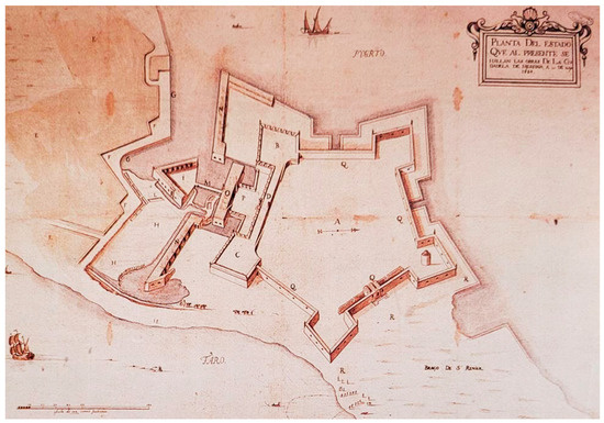
Figure 1.
Drawing by C. de Grünenbergh, showing the state of the works in May 1684 of Messina’s Royal Citadel, located in the Terranova district. (From the book: Aricò, N. (Ed.). (2002). La Penisola di san raineri: Diaspora dell’origine. Messina: Sicania).
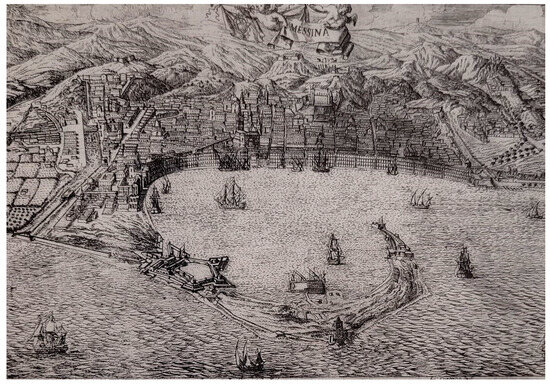
Figure 2.
Map of Messina made by Caetano in 1740, showing the port and its Royal Citadel. (From the book: Aricò, N. (Ed.). (2002). La Penisola di San Raineri: Diaspora dell’origine. Messina: Sicania).
Research on the site’s historical background has testified to the fortification’s high architectural value. As a first example, the Citadel contains both architectural elements from the Italian and the Dutch schools of defense; this makes the Citadel an exemplary piece of architecture [11]. A second example is the importance of resilient and strong building techniques, testified by the fact that the remains are still present today after destructive wars and natural disasters (Figure 3 and Figure 4).
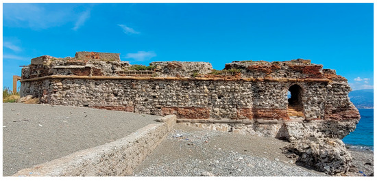
Figure 3.
Photograph taken on-site, showing the West elevation of the cistern.
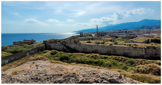
Figure 4.
Photograph taken on-site, showing the site of the Royal Citadel with, on the left, the cistern.
2.3. The Site’s Historical Value
In addition to the elaborated ‘architectural value’ (Figure 5), the site has a very high historical value that many city inhabitants do not know or have forgotten.
The Royal Citadel is of great historical importance and deserves to be acknowledged. The fortification was the center of many great sieges, which played an essential role in the city’s past, for example, the 1713 siege during the War of the Spanish Succession. Furthermore, it was the center of the start of the Sicilian revolution, the political and social movements of which were the start of the unification process of Italy [11].
The rich history of the site does not begin at the fortification’s birth but starts long before. The first occupation of this piece of land dates to the sixth century BC; the settlement was called ‘Zanclon’ or ‘Zancle’, which translates to scythe [12]. Therefore, the soil of the sickle is additionally of great archaeological value.
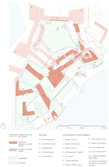
Figure 5.
Plan of the site of the Royal Citadel traced from the photogrammetric orthophoto. An estimation of the whole fortification was drawn from old maps. (Authors, 2023 [13]).
A significant contribution of the research within the historical background of the site and its surroundings is understanding the shift toward the site’s current forgotten state. Reasons for the destruction and abandonment of the site are mainly found in the new needs during the first decades of the 20th century.
In the aftermath of the destructive earthquake of 1908, the sickle was destined to play a part in the commercial and industrial resurrection of the city. This growth was believed to be vital for the recovery and rebuilding of Messina after the earthquake [8].
This new need ensured that the site of the Royal Citadel, surrounded and occupied by industrial and waste-related activities, was mentally and physically cut from the urban fabric. While, ‘A second cause is the poor management of the site in recent history, mainly due to political and administrative policies’ [13].
This poor management has, among other reasons, ensured the lack of a general urban planning system. This translated into continuous demolition actions as consequences of decisions responding to momentary needs [9].
What could be concluded from the research into the historical background to consider for the revalorization of the site is the creation of a functioning urban planning system and identity development.
3. Digital Documentation of the Site with a Focus on the So-Called Cistern
3.1. Digital Recording Strategy
The complexity of the site required digital recording technologies able to capture the irregular geometry of the surfaces with a metric accuracy suitable for producing different types of deliverables. Additional constraints were time limitations and access to specific parts of the site.
The on-site survey was carried out in two phases using digital photogrammetry and laser scanning. The project was georeferenced with ground control points (GCPs) measured with an Emlid Reach RS2 receiver connected to Sicili@net, a positioning network by Sezione di Catania Osservatorio Etneo INGV (Figure 6 and Figure 7).
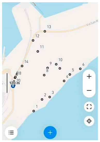
Figure 6.
Site map showing the location of the GNNSS measured points.
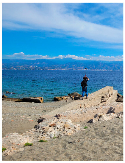
Figure 7.
Photograph taken on-site, showing the measuring of the GNSS points.
Digital recording was conducted with a multi-scale approach. The use of RTK GNSS allowed the measuring of the coordinates of a set of points distributed around the entire complex in the Italian reference system RDN ETRF2000 (2008.0). The undulation value from ellipsoid to orthometric elevation was calculated using the Italian geoid ITALGEO2005.
A drone mission was executed to capture a photogrammetric block (470 images), including normal and convergent images, which were then processed with Agisoft Metashape to produce a digital orthophoto with centimeter-level resolution, which was then digitized in CAD to obtain a site map. Site levels were determined from the photogrammetric point clouds.
A second manual flight was carried out around the cistern. In this case, the photogrammetric block has a geometry that provides the horizontal surfaces (such as in the flight on the entire site) and the external elevations. The use of a drone also allowed us to record those parts facing the sea, which are also more subject to erosion. Photogrammetric processing provided a high-resolution orthophoto of the cistern in the cartographic plane and orthophotos of the external elevations. A dense point cloud and a textured 3D model are also available.
The control points measured with the GNSS receiver allowed the georeferencing of both photogrammetric projects, with RMSE values lower than ±4–5 cm being obtained. In the case of the flight capturing the entire area, 19 control points were included in the photogrammetric project, resulting in RMSE values of about ±2–3 cm for the east and north, whereas the RMSE along the elevation was about ±3–4 cm.
Scans were acquired and registered using targetless methods (ICP), whereas ground control points were used to georeference the consolidated point cloud (Figure 8). Scans were registered among themselves with an overall error of about 0.7 cm, then control points were added to the project, resulting in an overall georeferencing error of ±2–3 cm. The photogrammetric project around the cistern had a higher level of detail, and some control points were also added from the registered laser scans. The overall RMSE for this project was about ±1.5–2 cm.
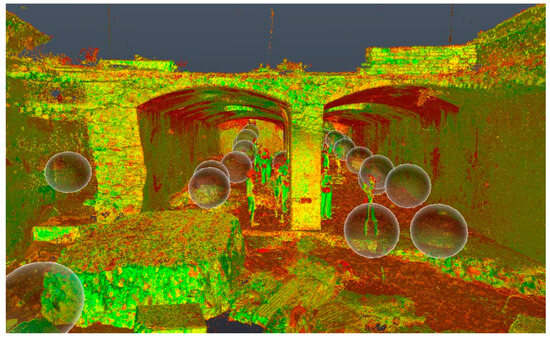
Figure 8.
Interior view of the combined point cloud, shown on the program ‘ReCap’.
A 360 video was also acquired to have visual documentation during the restitution phase, in which some details could not be clear from laser scanning and photogrammetric deliverables. The camera used was an Insta360 One RS.
3.2. Results of the Documentation of the Cistern
‘Documentation of cultural heritage, broadly defined, includes two main activities: namely, the capturing of information regarding monuments, buildings, and sites, including their physical characteristics, history, and problems; and the process of organizing, interpreting, and managing that information’ [14]. Both of the above activities were applied on the cistern of the Royal Citadel and will be briefly described in this chapter. ‘The documentation process of the remains plays an important role in the site’s future. It contributes to assessing the values and significance of the heritage in question; guiding the conservation process; providing a tool for monitoring and managing heritage while creating an essential record; and communicating the character and importance of heritage’ [14].
Apart from outdated site maps, no digital documentation is available on the Royal Citadel site. Because of the complex’s large size, the documentation campaign focuses on a smaller part, namely, the cistern.
The documentation of the remains of the cistern contributes to the understanding of its building techniques and evolution throughout time. As the historical background of the cistern is unknown, hypotheses concerning its past result from its documentation. In addition, the documents form a reference point to which further monitoring or documentation campaigns can be compared. From the information on the point clouds, plans, sections, and elevations were created for the cistern. These drawings, made with the software AutoCAD, give a greater insight into the dimensions and structures of the building (Figure 9).
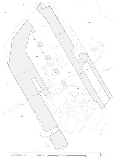
Figure 9.
Plan of the cistern drawn from the point cloud.
The created drawings further serve as a base map on which additional informative layers can be added. A first map with a secondary layer estimates the completed fortification; this was created with information from ancient maps. By overlapping current and ancient plans, additional remains of the site were recognized, which currently are not indicated as protected remains of the site (Figure 5). Examples are a part of the ‘Porta Grazia Ravelin’ and part of the ‘San Diego Falsa Braga’’.
To get a better understanding of the remains, a material and damage analysis was carried out. Those mappings are visually represented on the base drawings of the documentation campaign. Within the scope of this article, we have opted only to present one example per identified sub-category.
The material study distinguished several categories, from which the first category includes the different types of masonry (Figure 10 and Figure 11). The different bonds and materials used for the masonry help us understand the building techniques and evolution. Furthermore, the identified types of masonry can be cross-referenced with the masonry of other remains on-site to examine similarities.
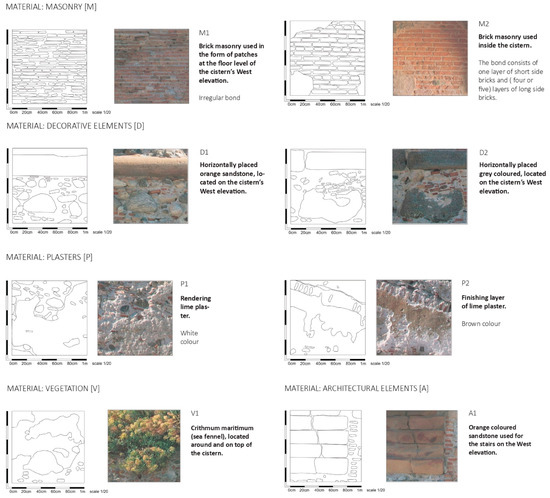
Figure 10.
Index of the material analysis with the first sub-category for each shown.
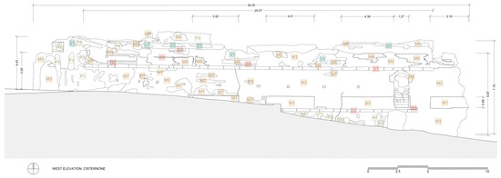
Figure 11.
West elevation of the cistern combined with material mappings.
A second category is the plasters, which appear to be a former finishing layer of the building. Also, more recent plaster layers are distinguished from the original ones here. A third category of materials is the decorative elements used for the building, with, for example, horizontally placed stone elements, which are also seen on the other remains of the fortification. Another addition to the building is the vegetation with which the remains are covered. The last category is the architectural elements present on the site.
The damage analysis was carried out in a similar way, namely by categorizing different changes in condition. The approach to classifying these changes was executed in line with the 2008 ICOMOS damage atlas [15], as well as the consequent European Technical standards on the Conservation of cultural property and cultural heritage, which include important updates [16,17] (Figure 12 and Figure 13).
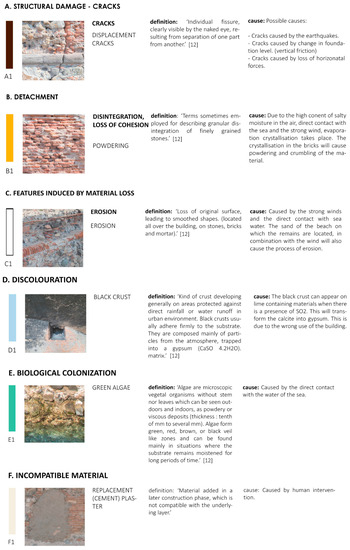
Figure 12.
Index of the degradation analysis with the first sub-category for each shown.
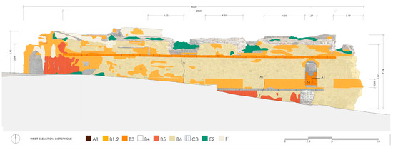
Figure 13.
West elevation of the cistern combined with damage mappings.
The first category is structural damage. The cistern is already strongly devastated as half of the roof and the south wall are scattered on the ground. The pattern and location of cracks give more information on how the remains are further deteriorating and could help establish structural consolidation plans.
A second category is detachment, which is caused by the crystallization process due to the high content of salt in the air and the direct contact with salt water. This phenomenon is seen in all types of materials, such as mortars, bricks, and the local natural stone.
The third category is features induced by material loss, which is caused by high and intense erosion. The remaining categories are discoloration, biological colonization, and incompatible materials.
The material and damage mappings serve as a valuable source of information as the obtained information is helpful in the creation of a treatment strategy. Furthermore, the drawings gained from the documentation campaign serve as the first digital documentation of the cistern. In the case of further neglect and deterioration, it serves as a testimony of the building and its architectural features.
From the documentation process, some conclusions were drawn. First, because of the high level of erosion caused by direct contact with seawater and the strong winds, the cistern is rapidly crumbling. The south wall and parts of the roof have already collapsed. The further collapse of the building can be evaluated through the mapping of the crack patterns and previously crumbled parts. From those mappings, the walls are collapsing towards the sea.
Secondly, the survey gave an insight into the cistern’s past. The recent building materials observed at the cistern testify to the use of the building in recent history. This is confirmed by damage caused by human activity, namely the black crust. This black crust is visible on the remaining ceiling of the ruin and is caused by industrial/polluting use of the interior.
As no written information is available on the cistern, its construction date is also unknown. However, similar building materials and architectural features were found between the cistern and other remains on-site; this might signify that the cistern was built around the same period as the fortification.
Finally, the documentation contributed to a better understanding of the cistern’s architectural features. Additionally, more information about the building was gained by combining the digital survey with other sources. These few sources concern drawings and pictures. To give a first example, the drawings/photos helped us understand the complete shape of the building, which showed that there used to be a south wall at the waterline. The remains of the south wall’s foundation were identified by overlapping the old plan and the recently generated drawing. The wall’s foundation is located underwater and, therefore, hard to identify on-site.
A second example concerns the traces, which indicate a connection between the cistern and the S. Stefano counterguard. Those traces were found on two illustrations dating from the 20th century. The recent materials’ presence could confirm this hypothesis at the location of the connecting infrastructure. Examples of those materials are the grey-colored plasters and recent brick additions. A concluding hypothesis could be that an additional shelter was constructed to support the active industry when small industries were active on-site.
The documentation of the site further helped in understanding its past, character, and fragilities. These are reflected in the values of the site, which are important to understand in creating a future for the site. The massive walls, up to six meters thick, testify to the great defensive architecture. In addition, the construction techniques resilient to destructive wars and earthquakes contribute to this significant architectural value.
Among others, the massive walls, ramparts, and the citadel’s star shape create the military feeling of the site. Therefore, this feeling and awareness are of great importance as it gives a great insight into ancient defense systems. The military feeling of the massive fortification, in combination with the fragile landscape and the beautiful Strait of Messina, further contributes to its great aesthetical value.
Answers concerning the workings of the cistern were not reached through the digital documentation of the ruin. However, the documentation of the site has contributed to understanding its construction techniques, weaknesses, and values. Further actions that could help to understand how the water was stored and used within the cistern include the study and comparison of similar case studies.
4. Re-Use Proposal for the Royal Citadel of Messina
4.1. Re-Use Suggestion Framework
4.1.1. Material Conservation
The research presented in the previous sections allows a sustainable and holistic proposal for the site of the Royal Citadel to be designed. After all, the responsible and sustainable use of the site provides the best protection for this heritage asset [18].
One part of the proposal deals with suggestions for conserving the surveyed cistern (Figure 14). A physical barrier between the cistern and the sea in the form of a dyke is suggested as most harm is inflicted on the building through direct contact with the sea. Furthermore, a layer of sheer whitewash is suggested to protect the remains from the strong winds, which contain a high concentration of salt particles. The consistency is to be determined after the evaluation of the remaining layers of plaster. The decorative elements made from sandstone are not suggested to be covered with whitewash as they return to other parts of the fortification. Furthermore, crack monitors can be installed during the stability investigation, and possible structural interventions can occur. In general, only the necessary restoration interventions are suggested.
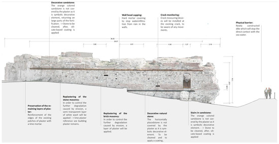
Figure 14.
Image of proposal interventions. Shown on the West elevation of the cistern.
The conservation of the other remains of the fortification can be determined after a complete documentation and investigation phase.
4.1.2. Comparative Case Study: The Submarine Base at Saint-Nazaire, France
In addition to combining the research results of the previous sections, an internationally relevant comparative case study was examined. The case study concerns a submarine base built during the Second World War by German troops. The base is located at the port of Saint-Nazaire, the outer harbor of Nantes, France. The analysis of this specific site helped with both learning how to deal with abandoned heritage and how to approach the site’s natural character, which arrives after an abandoned activity.
The analyzed case study concerned the revalorization project of the submarine base at Saint-Nazaire, France. At the beginning of the Second World War, the port was taken over by German troops, who started the construction of a new submarine base from which to start various marine operations. The large rectangular building not only housed maritime activities but also housed, among others, workshop spaces, a hospital, offices, and dormitories. ‘After the world war, the submarine base and its surroundings were completely disregarded and neglected, which turned the site into an industrial wasteland. It was only later, in the year 1994, that the municipality of Saint-Nazaire launched a revalorization project for the area. The project was called ‘Ville-port,’ which translates to ‘city-harbor’’ [13]. The project consisted of two phases with the first starting in 1996. The focus was to create more facilities relating to culture and tourism in the area around the base. Later, in 1999, the newly created district was connected to the submarine’s roof with the help of a long bridge (Figure 15).
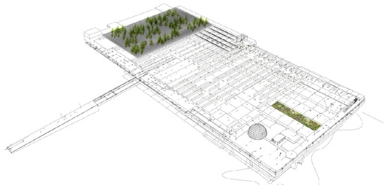
Figure 15.
Image of the roof of the submarine base at Saint-Nazaire. The image shows the interventions of the design project by G. Clément. On the left, the bridge between the roof and the new district is visible. (Morland. G., from the website: www.coloco.org, accessed on 20 September 2023).
The project’s second phase focused on how the re-use of the submarine base itself could contribute to the revalorization of the site. Various activities and functions were proposed and installed in the building. The first activity is the introduction of the ‘Alvéole 12’–theatre, which allows concerts and other performances to take place. A second function of the building is the interactive maritime museum, permitting guests to visit the interiors of the building and its submarines. The last primary function is the rooftop project of a landscape designer and writer, Gilles Clément, called ‘the third landscape’, a concept that can be defined as a neglected land resulting from the abandonment of an activity, a space that neither expresses nor submits power [19].
Other activities at the site are an information point for the tourist office and a bar. Finally, a site is provided for the training center of the National Sea Rescue Society.
The garden of ‘the third landscape,’ located on the roof of the building, consists of three typologies. ‘The first one is the forest of Aspen trees, which counts about 107 trees. They are placed on the roof and pop out between elevated concrete beams. The second designed area is the garden of the family of ‘Sedum’ plants. Here, different roof chambers are covered with plants that can survive on the concrete soil, with for example, ‘Sedum’. An opening is created through the compartments, which function both as a perspective view and as a water channel (Figure 16). The last garden, ‘the label garden’, allows new species of the plant kingdom to arrive by the strong winds. Those species are, after their arrival, identified and labeled (Figure 17)’ [13].
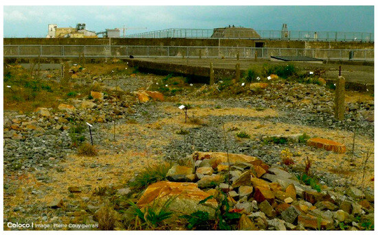
Figure 16.
Photograph taken on the roof of the submarine base. Showing the ‘label’ garden. (Couy-Perrais. P., from the website: www.coloco.org, accessed on 20 September 2023).
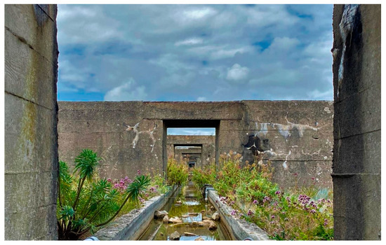
Figure 17.
Photograph of the garden where the sedum family plants are located. The picture shows the perspective created through the compartments. (Authors 2023 [13]).
The designer Gilles Clément explains that ‘The flora of neglected lands is not exclusive of its natural indigenous parade’ [19], which makes it a territory of diversity. ‘To maintain a balanced diversity, a low pressure from the anthropized territory is required’ [19]. ‘This low pressure will have a positive influence on the environment. It is therefore important to partly maintain this status of neglection to maintain its valuable diversity.’ [13].
What could be concluded from the rooftop project is that the minimal interventions allowed the continuation of the site’s character and diversity. Together with the other re-use activities in and around the building, the site is perceived as a must-see landmark of the city. Furthermore, various functions and activities are key in an inclusive and sustainable revalorization project. This variety of functions makes the place popular for tourism and contributes to making the site a valuable space for the local community.
Although they are quite different cases, the Saint-Nazaire submarine base and the Citadel of Messina share some similarities: an important historical role that has since diminished, leading to significant consequences for the preservation and perception of both sites; the extraordinary natural landscape in which they are situated and, as a result, the beauty they maintain even in a state of ruin. In both cases, the “minimal” approach appears to be the most appropriate for a new use.
4.1.3. Proposed Functions and Activities
The other facet of the suggestion framework focused on revalorizing the site through a community-based master plan. The re-use project proposes various functions and activities for the site. However, these suggestions lack the influence of the public’s opinion. Including the inhabitants in the design process contributes to a sustainable take on the revalorization plan and helps create site awareness. Therefore, community participation is strongly recommended in planning the site’s future activities. Furthermore, the surroundings and the site’s setting are essential in revalorizing the site. Suggestions regarding this topic are not made within the current article. However, additional studies and interventions on the site’s surroundings are very important.
‘The awareness and connection between the inhabitants and the site are necessary for the restoration process and its further maintenance’. It is important to note that the ‘rehabilitation process is not a goal on its own but rather a tool to reactivate the cultural heritage and provide a space for the community, for cultural, social, and economic functions’ [18]. Creating awareness of a neglected site is not accomplished using a juncture; it takes a generation to make a positive connection. Therefore, targeting a younger generation is essential to create a bond with the site. At the same time, the broader public should be addressed as the remains are part of the historical background of every citizen of Messina.
The proposed project involves multiple stakeholders, first, with the port authority as the site’s owner. Secondly, government instances must be involved and frequently updated on the project. Third, there would be a collaboration with local universities and schools. A last important category is the involvement of NGOs supporting the proposed activities. More specifically, the site is divided into different functions and activities. As mentioned above, the diversity of the provided functions is essential for a sustainable future of the site. Hence, the proposed activities are social, economic, and cultural and are represented in Figure 18 [13].
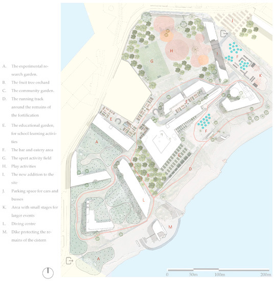
Figure 18.
Master plan of the proposal showing the different functions and activities of the site.
A first intervention, located in the southwest of the site, is creating a space protected from human activity. Here, researchers and universities can identify and study the natural arrival of species. Moving towards the northeast, a community garden and an educational garden will ensure the interaction between nature and both the younger and older generations. The educational garden would be designed for school excursions, where younger children can learn about cultivating and caring for plants. This bond will create a connection between the inhabitants and the heritage site. Local NGOs or other bottom-up initiatives will organize the above-proposed activities. Throughout this area of the site, leisure and sports activities would be installed. Running and walking trails would be provided surrounding the remains along those trails to inform the visitor, and texts and images concerning the site’s historical background would be spread.
Located in the northeast of the site, a new addition to the site is introduced (Figure 19). This addition would reconnect the two remains of the former east front curtain. The first reason for the connection is to recreate the feeling of the former pentagonal inner courtyard of the fortification and to strengthen the massive fort’s character. ‘It is suggested that for the new construction, a material should be chosen which embraces its robust and strong character, without trying to imitate the remains’ [13]. A second motive for introducing a new element is to house the functions requiring too many adjustments if installed inside the remains. Within the latest addition, a space will be foreseen for presenting the historical collection of the Royal Citadel, together with a space for temporary exhibitions. Other activities taking place inside concern the restaurant, bar, and restroom facilities.
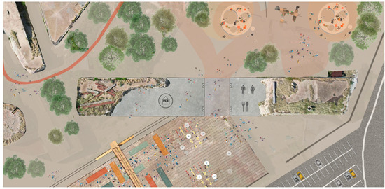
Figure 19.
Proposal for the industrial remains on the site, together with the remains of the ‘Porta Grazia’. A connection is created between both remains, to show its once completed form.
The new introduction would be directly connected to the industrial part of the site, where the industrial traces will be kept as a relic of the site’s former industrial use. The traces in question consist of a large, hardened surface, which is perfect for hosting large events such as concerts and food festivals, and a large crane.
The last activity proposed for the site is the introduction of a diving center. Diving-based activities appear popular on-site as many shipwrecks are present in the bordering waters. The opening of the diving center will make sure that in the future, these activities can take place in a more safe and controlled manner and will further attract tourism. This will be achieved through the organization of classes and the provision of reliable diving gear. An organization such as ‘PADI’ (Professional Association of Diver Instructors) could help manage this activity.
4.2. The Contribution of the Re-Use Proposal
The proposal is a suggestion framework that can serve future studies and projects. This master plan consists of various topics that would contribute to preserving and revalorizing this remarkable heritage asset. The first focus is the importance of this being a community-based project. The public should be involved in managing the site and its possible activities, as it encourages the bond between the inhabitants of Messina and its Royal Citadel.
A second highlighted topic is the assignment of suitable activities and functions, which is considered a valuable protection to the heritage asset [13]. The new activities are to be determined after considering citizens’ opinions and gaining knowledge about the historical and current state of the site and its surroundings.
A case study that faced similar challenges was studied as a last contribution to provide a holistic and sustainable approach to the revalorization project. From the case study in Saint-Nazaire, the variety of functions and activities contribute to a successful revalorization project. ‘Providing certain cultural and leisure activities will attract tourism, which has not only a positive influence on the use of the site but also the city’s economic situation’ [13].
The last focus stresses the restoration and consolidation of the remains. ‘Before any intervention, the remains of the Royal Citadel not only ought to be researched and analyzed by various experts but should also be documented accurately. The remains strictly require necessary interventions to preserve the remains and enhance their character’ [11].
5. Discussion
Within the current research trajectory, a small participation study was conducted as an online survey. This is to get a better understanding of the opinions and perceptions of the city’s inhabitants of the Royal Citadel. However, the obtained results are not used in this article as they do not represent the wider public. This approach is important in an inclusive and holistic take on the revalorization plan. Therefore, it is suggested to not only inform the public about possible future projects but also to engage the community. Within the engagement of the inhabitants, the broader public should be targeted [20]. Here, the interaction between the respondents and the planning/city administration should not be forgotten.
In addition, within the urban analysis of the research, the neighbors of the Citadel were addressed. Industrial and maritime functions surround the fortification. Examples of the activities taking place on-site are the cruise terminal, shipbuilding activities, the navy arsenal, and the cargo port. The cargo port is directly connected to the railway tracks, which create a physical and mental border between the sickle and the city. The high industrial character of the sickle has made the whole area a peripheral and marginal space, which the city’s inhabitants avoid. The Royal Citadel is not the only site on the sickle cut from the urban fabric, two other historical landmarks are also located on the arm of San Raineri (Figure 2). At the end of the sickle, is the fortification of San Salvatore, a defense mechanism built in the mid-16th century as a reaction to fear of the expanding Ottoman empire. A second landmark is the monumental lighthouse/lantern, located east of the Royal Citadel.
The industrial surroundings of the fortification play an important role in the revalorization of the site. Further research on this topic is, therefore, highly suggested. The revival of the landmarks of the arm could greatly contribute to the perception of this piece of land.
6. Conclusions
This article aimed to assess how research on neglected and forgotten heritage, more specifically on the Royal Citadel of Messina, contributes to the creation of a suitable re-use proposal. The analysis approached the inquiry through methodologies within the historical, architectural, and participative fields. The proposal serves as a base document on which further studies and projects can build. Suggestions were made concerning various types of possible activities and functions, whilst considering the enhancement of the site’s values.
In addition to restoring the remains, having a suitable use is a valuable protection for the remains. To achieve this, an awareness of the site needs to be created. Within this process, community and other stakeholder involvement is key. For the restoration works, documenting the remains is crucial before any interventions. To maintain its character and values, only the strictly needed interventions are required. The article combines existing and newly created data. Within this framework, guidelines concerning the restoration and revalorization of the site were highlighted. The results of the holistic research aspire to impact the creation of a suitable and sustainable future for the site of the Royal Citadel of Messina.
Author Contributions
Conceptualization, L.B., C.D.P., A.V. and A.M.O.; methodology, C.D.P. and A.M.O.; software and validation, C.D.P. and L.B.; investigation, L.B., C.D.P. and A.M.O.; writing—review and editing, L.B., C.D.P., A.V. and A.M.O.; supervision, L.B., A.V. and A.M.O. All authors have read and agreed to the published version of the manuscript.
Funding
This research received no external funding.
Data Availability Statement
Data sharing not applicable.
Acknowledgments
This article incorporates some of the process and findings of the author’s graduate thesis, carried out within the Master of Conservation of Monuments and Sites (KU Leuven). A part of the research was achieved during the author’s traineeship at the departments ABC and DASTU, from Politecnico di Milano. This internship took place under the guidance of L.B. and A.M.O. The promoter of the thesis was A. Vandesande. The authors also want to thank the Autorità di Sistema Portuale dello Stretto di Messina for their support in providing access to the Citadel. We thank Osservatorio Etneo—Sezione di Catania for granting us access to the SICILI@NET GNSS network.
Conflicts of Interest
The authors declare no conflict of interest.
References
- Oteri, A.M. Messina l’Italianissima. Il volto della città post-risorgimentale (1847–1880). In Storia Urbana; XXXIV, 132–133; Franco Angeli: Milan, Italy, 2011; pp. 323–365. [Google Scholar]
- Adams, D.; Larkham, P. Contesting urban monuments: Future directions for the controversial monumental landscapes of civic grandeur. Int. J. Herit. Stud. 2022, 28, 891–906. [Google Scholar] [CrossRef]
- Liu, Y.; Dupre, K.; Jin, X. A systematic review of literature on contested heritage. Curr. Issue Tour. 2021, 4, 442–465. [Google Scholar] [CrossRef]
- Sulfaro, N. A memory of shadow and of stones. Traumatic ruins, Conservation, Social processes. ArcHistoR 2004, 2, 144–171. [Google Scholar] [CrossRef]
- Turnbridge, J.E.; Ashworth, G.J. Dissonant Heritage: The Management of the Past as a Resource in Conflict; Wiley: Chichester, UK, 1996. [Google Scholar]
- Battilani, P.; Berinini, C.; Mariotti, A. How to cope with dissonant heritage: A way towards sustainable tourism development. J. Sustain. Tour. 2018, 26, 1417–1436. [Google Scholar] [CrossRef]
- Huyssen, A. Present Pasts: Urban Palimpsests and the Politics of Memory; Stanford University Press: Redwood City, CA, USA, 2003. [Google Scholar]
- Saija, M. La perdita dell’agorà. In La Penisola di San Raineri; Aricò., N., Ed.; Sicania: Messina, Italy, 2002; pp. 201–232. [Google Scholar]
- La Spada, E. Gli urbanisti e la Falce. In La Penisola di San Raineri; Aricò., N., Ed.; Sicania: Messina, Italy, 2002; pp. 233–260. [Google Scholar]
- Antudo. Available online: https://www.antudo.info/messina-porta-grazia-2/ (accessed on 25 July 2023).
- Riccobono, F.; Berdar, A.; Fauci, C.L. La Real Cittadella di Messina; EDAS: Messina, Italy, 1988. [Google Scholar]
- Aricò, N. Segni di Gea, grafie di Atlante. In La Penisola di San Raineri; Aricò., N., Ed.; Sicania: Messina, Italy, 2002; pp. 19–88. [Google Scholar]
- De Pauw, C. The Neglected Remains, Hidden in the Dunes of a Rich Historic Past. Proposal for Reuse and Conservation of the Monumental Remains of the Royal Citadel of Messina. Master’s Thesis, KU Leuven, Leuven, Belgium, 2023. [Google Scholar]
- LeBlanc, F.; Eppich, R. Documenting Our Past for the Future, Getty.edu. Available online: https://www.getty.edu/conservation/publications_resources/newsletters/20_3/feature.html (accessed on 17 March 2023).
- Icomos: Illustrated Glossary on Stone Deterioration Patterns. 2008. Available online: https://openarchive.icomos.org/id/eprint/434/ (accessed on 15 November 2022).
- EN 15898:2019; Conservation of Cultural Property—Main General Terms and Definitions. European Standards: Pilsen, Czech Republic, 2019.
- EN/TS 17135:2021; Conservation of Cultural Heritage—General Terms for Describing the Alterations of Objects. Institute for Standardization of Montenegro: Podgorica, Montenegro, 2020.
- Clément, G. Manifesto of the Third Landscape. Available online: https://teh.net/wp-content/uploads/2022/08/TEH-Publication-Manifesto-of-Third-Landscape-145x225mm-2022-WEB-Spreads.pdf (accessed on 10 April 2023).
- Nigrelli, F.C. Appunti sul l(u)ogo. In La Penisola di San Raineri; Aricò., N., Ed.; Sicania: Messina, Italy, 2002; pp. 319–328. [Google Scholar]
- Neagu, M.; Matthias, R.; Nils, S.; Philip, S. Community-Led Urban Strategies in Historic Towns (Comus). 2017. Available online: https://rm.coe.int/comus-communities-at-the-heart-of-heritage-governance-principles-for-h/1680728eb4 (accessed on 13 May 2023).
Disclaimer/Publisher’s Note: The statements, opinions and data contained in all publications are solely those of the individual author(s) and contributor(s) and not of MDPI and/or the editor(s). MDPI and/or the editor(s) disclaim responsibility for any injury to people or property resulting from any ideas, methods, instructions or products referred to in the content. |
© 2023 by the authors. Licensee MDPI, Basel, Switzerland. This article is an open access article distributed under the terms and conditions of the Creative Commons Attribution (CC BY) license (https://creativecommons.org/licenses/by/4.0/).