1. Introduction
Cultural heritage management involves the blending of science, history, art, architecture, and policy with historically important and environmentally sensitive heritage sites, especially those in arid environments, remaining susceptible to human interaction and induced deterioration in addition to natural stresses [
1,
2,
3]. Rock art represents one such tangible piece of cultural stone heritage, and understanding both rock art and its (potential) decay remains important for its management, conservation, and/or protection [
4,
5,
6,
7,
8,
9]. Non-invasive techniques in rock art assessment, such as the Rock Art Stability Index [RASI, see 7], provide a baseline study from which these important pieces of cultural heritage may be identified and analyzed for trends in polygenetic deterioration processes. RASI assessments incorporate multiple stone decay aspects, including general condition of the host stone, its substrate, vulnerability to perceived and inherent decay processes, and external/internal influences.
This project’s goal centered on creating a much-needed baseline for the thousands of petroglyph panels in Petrified Forest National Park (PEFO), Arizona, USA, with the aim of monitoring and reassessing the sites across different time frames to help PEFO’s cultural resource management team make informed decisions regarding irreplaceable rock art and inscriptions that have endured increased tourism, human contact, climate change, and time. Although RASI has been—and continues to be—used successfully in varying environments around the world for more than a decade (cf., [
4,
8,
9,
10,
11,
12]), this article centers on the contribution RASI made to furthering the management of rock art sites in the arid desert conditions of PEFO. This article begins with a brief overview of the study’s location—including prominent climate patterns, geology, and regional geomorphology—as well as an in-depth explanation of RASI. Then, before offering a succinct conclusion, site assessment results are presented for several key locations within the park, with specific attention focused on the dominant rock decay processes affecting and influencing each site.
Site Setting
Managed and curated by the United States National Park Service (NPS), the Petrified Forest National Park (PEFO) covers nearly 600 km2 and houses a myriad of geologic, paleontological, and historic resources. Roughly 200 miles southeast of the world famous Grand Canyon National Park, the stunningly colorful hyper- and semi-arid Painted Desert sits at the southern rim of the massive Colorado Plateau, resulting in dramatic multi-toned canyons, buttes, and valleys seen throughout the park, often scattered with the glittering, colorful petrified wood that give the park its name.
Geologically-speaking, PEFO hosts two formations: one from late Triassic Period (227–205 mya) and the other from Mio/Pliocene Epoch (4–8 mya). The latter consists of paleolake lacustrine deposits and volcanic (mostly phreatomagmatic) activity, and the former being mainly fluvial deposits, with a fairly-rich accompanying fossil record [
13]. On top of the Mio/Pliocene deposits rests sand, alluvium, and several small dune areas—some as recent as 1000 ya—deposited during the late Pleistocene and Holocene Epochs. Some of these sediments are still loose, and sometimes transported by aeolian and/or intermittent stream processes, and contain more recent fossil evidence (e.g., elephant and mammoth). Perhaps not surprisingly, the PEFO landscape hosts a mesa-butte topography—including some towers and hoodoo—alongside its more traditional badlands topography, where the more resistant caprock protects its upper rock layers, but leaves its sides exposed to greater decay. Most of the rock art in PEFO can be found in the Newspaper Rock sandstone formation of the Blue Mesa Member.
Considered a high desert with little high-altitude aeolian factors, air quality remains excellent, and PEFO is short-listed to become an International Dark Sky region. Still, changes in weather occur throughout the year, most notably the Arizona Monsoon season. While PEFO receives an average of 25 cm of precipitation each year, summer thunderstorms can bring rapid changes to the Park, often in the form of flash floods which reshape the landscape. While summer high temperatures can reach more than 30 °C, winters can be starkly chilly, with lows reaching −5 °C and periodic snow cover. The still, calm, winter air, however, sets the stage for 150+ km visibility, further enhancing PEFO’s aesthetic value.
2. Methods: Rock Art Stability Index
Usable by both non-specialists and experts alike, RASI has been designed as a non-invasive, cost-effective, and rapid field assessment technique centered on the decay processes associated with any stone type [
7]. A reliable and replicable system with minimal training time, completing a RASI assessment for a rock art site (or individual rock art panel) results in a score of instability severity, providing managers with a snapshot of the current state, strength, and potential longevity of rock art panels, or rock faces, with as fine a detailed assessment as necessary for any given project. Using these data, site managers can create specific priorities by integrating RASI results for individual sites in a geographic information system (GIS) database (cf., [
14,
15]), and those sites in greatest danger can then be mapped across scales—whether it be across a state, province, country, within a specific site, or the rock art panel itself.
The RASI classifies over three-dozen rock decay forms, under five broad categories, organized to facilitate training and aligned with rock decay literature (
Table 1). Researchers rate the severity of decay for each listed form or process on a 0–3 scale across the five overarching categories, resulting in six degrees of risk that coincide with specific scores (
Table 2). The first category focuses on the general site setting and overall geologic weaknesses in the host stone’s bedrock (e.g., rock hardness, lithification processes). Then, those portions of the rock art panel that could erode in the foreseeable future (e.g., scaling, flaking, roots, undercutting) are assessed. The third category accounts for loss of large pieces of stone (e.g., human activity, undercutting of the surface, roots), while the fourth category centers on smaller, incremental forms of rock loss/erosion, such as abrasion, flaking and scaling, lithobiont activity, and splintering, among others. Rock coatings usually help preserve rock art by stabilizing the host rock’s surface, but human rock coatings like chalk and graffiti degrade the surface and the art itself, and natural deposits such as salts lead to surface loss. Hence, both the potential preservation capabilities and potential for loss via rock coatings are captured in the fifth category. A sixth, qualitative category for assessing potential outside influences is also included in the RASI, allowing researchers to catalog basic observations that a site manager might use in their overall site assessment (e.g., livestock, visitor impact).
Collaborating with a National Science Foundation (NSF) funded applied education program by Mesa Community College, Arizona State University, and University of Colorado Denver, a Cooperative Ecosystems Study Unit grant between the National Park Service (NPS) and University of Colorado Denver, and the Rocky Mountain Middle School Math and Science NSF grant (also at University of Colorado Denver, see acknowledgements), RASI fieldwork was conducted periodically from spring 2009 to 2012 covering the entire geographic area of the park, including new park territory acquired during the project period. Wherever possible, RASI data collected corresponded with existing NPS archaeological records and surveys mapping rock art panels and sites to prevent redundancies or replication of site documentation. Additionally, many rock art sites in PEFO have been documented over the years by volunteers such as the Civilian Conservation Corps (CCC, a US government initiative in the 1930s), the American Rock Art Research Association (ARARA), and the Western Archaeological Conservation Center (WACC), and these data were occasionally used to aid in site and panel location efforts for this study. However, in some cases, new site surveys were collected in situ by an accompanying NPS staff member if none existed or records were deemed inadequate by NPS staff. To date, more than 300 sites and over 3500 individual petroglyph panels have been analyzed in PEFO using RASI over the project’s four-year duration.
3. Results
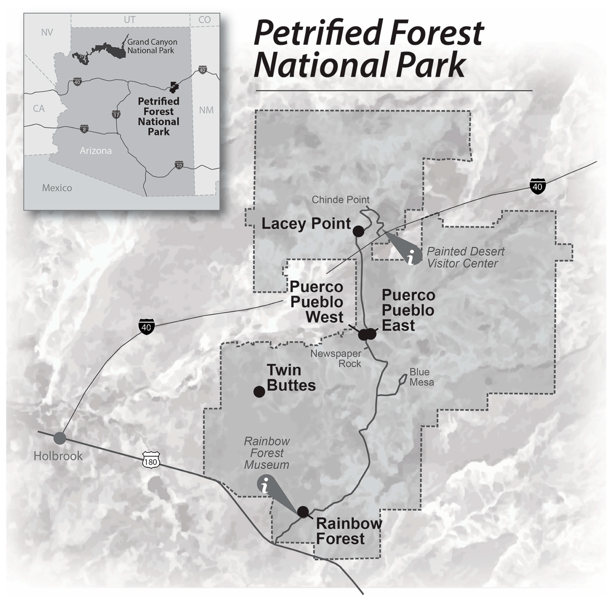
With the specific locations of many rock art sites remaining confidential (for protection purposes), this paper only presents data from five publicly known sites in different areas of the park: Lacey Point, Puerco Pueblo East, Puerco Pueblo West, Twin Buttes, and Rainbow Forest (
Figure 1). These five locations provide not only a broad geographic representation of rock art in the Park, but also an interesting range of human interaction and land-use. For example, Lacey Point, not far from the north park entrance and visitor center, was a popular trekking destination for several decades while Twin Buttes—located in the wilderness area—experiences very limited visitor access. The two sites at Puerco Pueblo also offer an interesting case study seeing as, despite their close proximity to each other, the east side of the highway is among the most heavily touristed rock art sites in the park with informational plaques, a short interpretive trail, and viewing platforms, while the west side is strictly monitored and restricted to NPS personnel access only. The last site, Rainbow Forest, is near the Rainbow Forest Museum, the Park’s archaeological and paleontology information center by the southern Park entrance, abutting a popular walking trail to view the parks famous fields of multicolored petrified wood. At this site, the petroglyphs are highly visible to visitors but are not the main attraction, and often remain overlooked. Additionally, all five sites exhibit prominent decay behaviors and conservation challenges found throughout the park (
Table 3).
3.1. Lacey Point
Perched on a small outcrop visible from the Park highway, Lacey Point was among the first sites recorded by the RASI research team, and then re-assessed in 2010 by a more experienced team in response to relatively inconsistent panel scores from the first data collection. Curiously, the second set of scores remained erratic, though slightly higher than the original scores—indicating the site either experienced noticeably significant deterioration between the dates of data collection or, more likely, the decay behavior exhibited at Lacey Point is more difficult to distinguish and threats are potentially masked by apparent stability. Further interpretation of RASI scores by trained rock decay (i.e., weathering) specialists revealed evidence to support the latter.
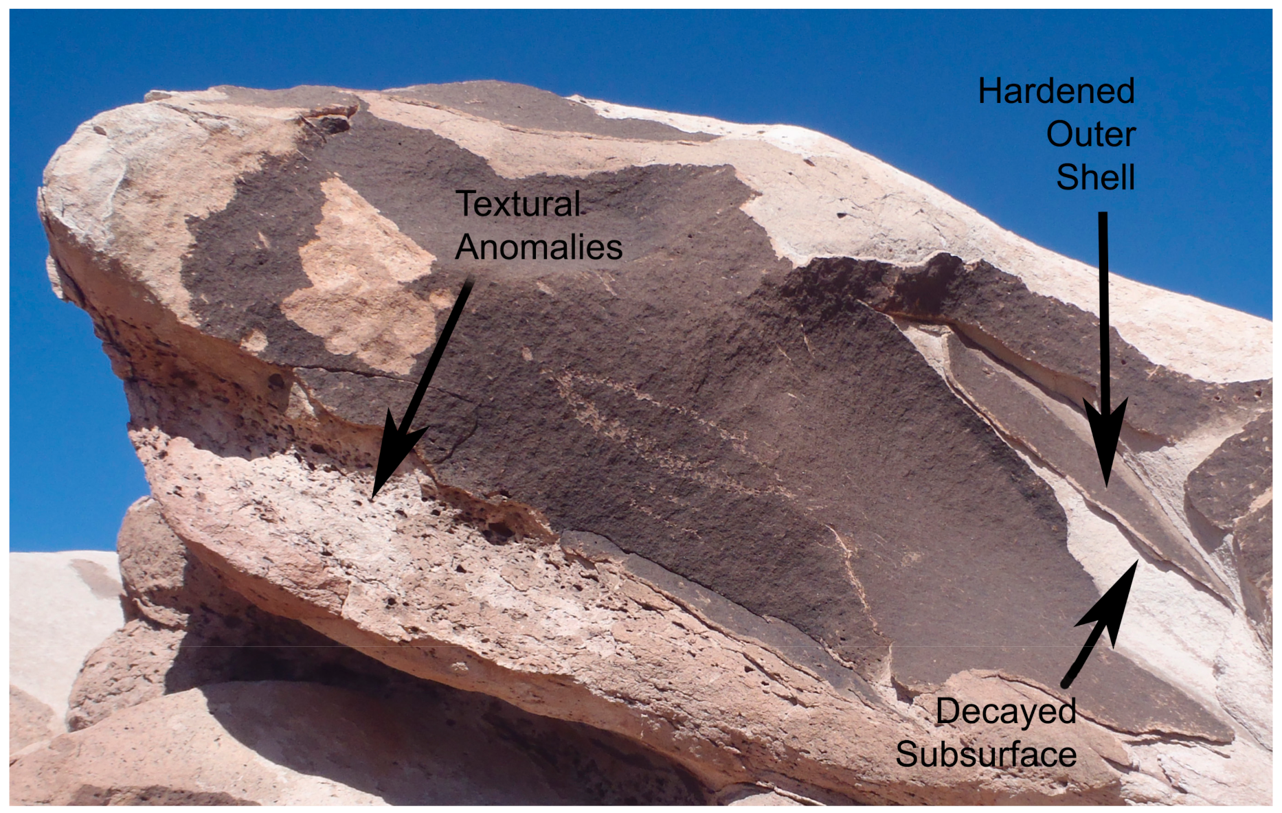
Structurally, the boulders are relatively stable, with only a few fissures (i.e., cracks) or signs of physical stress, therefore, the main concerns remain at the surface. The majority of panels at the site exhibited thick “case hardening” development, the buildup of a resistant “shell” across the stone [
16,
17]. This process is typically seen as beneficial, as it creates a generally more resilient surface, however, as seen at Lacey Point, small breaches or cracks in this protective coating consequently concentrate decay processes in subsurface areas, softening the stone beneath, and creating an extremely fragile substrate [
16,
18].
Regardless of how hardened or stable the surface has become as a result of the case hardening process, once the compromised inner layer decays entire sections of the panel detach from the host stone and are lost, explaining the discrepancy at Lacey Point: panels may appear stable to an untrained eye because of their hardened surfaces, but in reality, the site is immensely fragile (
Figure 2). In fact, nearly all the primary and secondary threats identified in the second RASI assessment at Lacey Point pertain to either partial or complete loss of surface material (see
Table 3).
Another potential influence of site decay behavior comes from relatively high visitation and human interaction. Historically, Lacey Point was a relatively well-known landmark for stagecoach travel in the mid–late 1800s as a halfway point layover between Inscription Rock, New Mexico, and Flagstaff, Arizona [
19]. Stagecoaches would regularly stop for extended periods of time allowing a much-needed respite for travelers, who then would investigate the area and interact with the rock art, sometimes leaving names or initials carved into/on stones. More recently, multiple piles of gathered pottery sherds and archaeological remains can be found around the outcrop, suggesting regular tourist activity at the site. Unbeknownst to visitors, who are presumably leaving their “treasures” in neat little piles for future hikers to enjoy, this hoarding behavior destroys the site’s archeological integrity and scientific viability for any future research. Along with the immense informational loss, artifact collection also falsely suggests that visitors can freely explore this site, potentially encouraging climbing on and around critically weakened rock art panels. The deceptively “stable” visual appearance of Lacey Point portrays a false sense of security that could become detrimental to the site’s long-term management and future conservation efforts, an issue the NPS can now address, supported by detailed RASI analyses for each panel at the site.
3.2. Puerco Pueblo East
This site was first recorded in 1988 by ARARA, though their map contained a few discrepancies, making some panels difficult to find. Still, Puerco Pueblo East represents the most visited site in the park, and largest by area. It includes several partial building footprint reconstructions and a short interpretive trail from the parking lot to the petroglyph viewing site. Being the most visited site means an abnormally high volume of traffic, and greater potential susceptibility to vandalism, scratching, theft of artifacts and lithics, and littering.
The motifs of this site are much more diverse than others initially surveyed for this study. Probably due to its proximity near the sacred Hopi (Native American Tribe) area of Puerco Pueblo West, the panels here are much more spiritual and include glyphs of prayer sticks and motifs of dances. Engravings of deer and sheep herds are also found throughout this site, as well as images of the infamous Nata’aska (a mythical, crocodile-headed, boogeyman-like creature from Hopi lore). Found at the top of the site, and perhaps this site’s most interesting panel is a solstice marker. Even though the site hosts a wealth of petroglyphs, it is almost completely void of lithics, most likely from relic hunting activities before the park was established.
The most dominant and potentially damaging decay forms and processes at this site include scaling and flaking. Minor, but still problematic decay mechanisms, include fissures dependent on lithification, fissuresols (i.e., "dirt cracking", see [
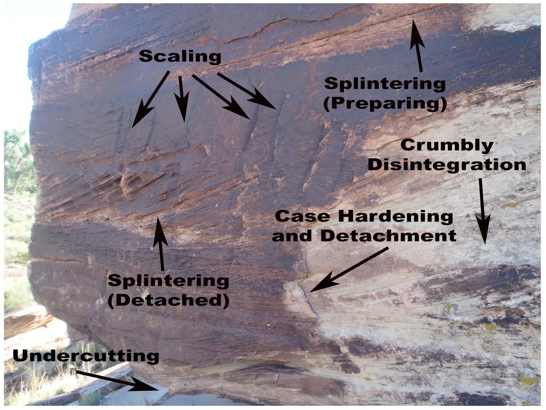
20]), and flaking on the rock panels and glyphs themselves. The highest scoring panel (i.e., most endangered) of the entire study was found here, an ultimate demonstration of panel instability and degradation. This highly eroded and highly decay-susceptible panel displayed advanced scaling, flaking, splintering, undercutting, abrasion, tafoni, rounding of petroglyph edges, and many other natural and anthropogenic concerns (such as graffiti). While this represents an extreme case, many other panels at this site displayed disturbingly similar deterioration concerns, such as panels 2–7 (
Figure 3). Situated precariously on a fallen boulder, this panel exhibits both lithologically dependent and post-formation stress (independent) fissures, indicating both intrinsic vulnerabilities between strata as well as external forces leading to advanced decay. As illustrated in the figure, many of the topical and surface decay processes, such as flaking, weathering rind development, and scaling are concentrated along these fissures. The widespread occurrence of splintering development also displays an inherent weakness along the stone’s natural bedding planes that presents a significant concern for future deterioration. The combination of these decay features, along with others to a lesser extent, earned the panel a total score of 88, well within the “Severe Risk of Decay” category.
Obviously closing the site to public access would be the most effective means of protecting the petroglyphs, but as this represents the most-visited site in the Park, such action is not feasible. That said, perhaps increasing surveillance and tracking the amount of foot traffic allowed in this area may help prevent unwanted vandalism and anthropogenic decay of the panels.
3.3. Puerco Pueblo West
Before this assessment, no previous recording had been conducted at Puerco Pueblo West, presumably because of its closeness to a sacred Hopi (Native American) site. The site also contains one of the oldest (8500 14C years before present, see [
21]) geometric rock art motifs, and hosts abundant animal and geometric motifs, the most prominent of which are snakes. Still, even though this site has not been promoted as part of PEFO’s rock art sites to the general public for decades, high levels of decay were discovered on its rock art panels, including vandalism and historic carvings.
Panels at this site are spread out and found along a steep slope and higher up on the cliff face and, as with the rest of PEFO, the geology is predominantly highly decayed sandstone and bentonite (clay), which has led to increasingly unstable slope conditions. In fact, several panels required remote analysis because of the dangerous slope conditions. Additionally, abundant ground-based wildlife is evident around this area including rabbits, packrats, and bats, which can further destabilize the area. Part of this instability could be due to a maintenance road being located only several meters from the main cluster of panels which has been in use for decades before access became restricted. Additionally, the area at the base of the sandstone cliffs was utilized as a campsite in the 1930s by the CCC workers in the Park, though the original campsite now lies beneath a more recent migrating sand dune.
In terms of rock decay forms and processes specifically, overall RASI assessment at this site suggests substantial damage from fissures dependent of lithification and fissuresols preparing to detach (i.e., “dirt cracking”, see [
20]). Fissuresols are micro-soil deposits found within fractures of the rock, and include a combination of rock coatings, aeolian fall out, and other decayed material [
22]. Other issues affecting destabilization of the panels include fissuresols already detached, flaking, scaling, and splintering (
Figure 4). Almost half of the more than 40 panels at this site were ranked as “severe risk of erosion”, with the remaining panels earning either an “urgent” or “great” risk score (
Table 3). The dangerously eroding and precarious cliff face, unstable geology, and potential anthropogenic impact leave this site in critical condition.
3.4. Twin Buttes
Conducted by the Western Archeological Conservation Center (WACC) in 1998, the original study of Twin Buttes recorded 71 panels, but did not produce a map of any kind. When the Park first opened, wagons carried visitors on a tour, and Twin Buttes was the first stop. Although it has been closed to the public for decades, there is still strong indications of heavy foot traffic in the area, and an archeological dig is also located just north of this site. The motifs at Twin Buttes include mostly desert animals and geometrics. Snakes and lizards are seen on many panels throughout this site, and images of fish have also been found—exceptionally interesting for an arid climate—as well as human footprints and multiple circles.
Environmental impacts are unique at this site. A nearby archeological site contains evidence of a farming community, and proof of a ruptured earthen dam between the two buttes—as well as and soils containing heavier amounts of iron and salts—denote water was present and might also suggest this area was once underwater. This previous exposure to water greatly affects the chemical and structural integrity of the rocks, destabilizing the crystalline matrix. Lithobionts—organisms such as lichens and mosses that live off rock minerals and coatings—remain prevalent at this site, sometimes covering entire panels. The desert vegetation is heavy in this area and causes abrasion and scouring on several panels. Another concern is considerable damage from abrasion by fluvial sediment transport. This occurs at the Twin Buttes site much more than any other site surveyed in this study, and could be due to its aquatic history or, perhaps more likely, its position in a flood susceptible area such as panels near or on the ground.
These environmental factors are reflected in the site’s RASI analyses (
Table 3). Plant growth near panels, abrasion, preparation for scaling, and rounding of petroglyphs edges all scored high and are reason for concern. Minor issues included flaking and scaling. The decay and erosion at this location remains intense but is mostly due to its location and the presence of water more so than any other site. The human impact here is noticeable but not critical, but the site still experiences frequent erosion events. Many panels have already succumbed to lichen or plant related degradation, and the lower-sitting panels are at great risk of abrasion or being buried in subsequent flood/fluvial events.
3.5. Rainbow Forest
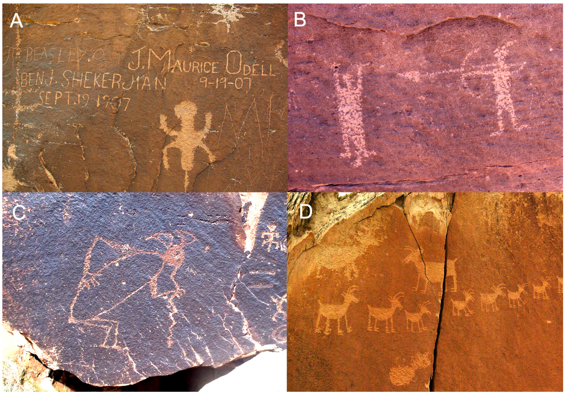
The southernmost site reviewed in this paper, Rainbow Forest, is located on the southeast slope of a large mesa overlooking the Rainbow Forest Museum and hiking trail. Built by the CCC during the 1930s, a stone stairway through the site to the top of the mesa is still used today. In addition, as was common at the time, some CCC participants created their own “artwork” on the rocks, such as initials or crude drawings. These inscriptions are now considered “historic” and protected under The National Historic Preservation Act of 1966. In 1988, ARARA documented 132 rock art panels at this relatively large site but, unfortunately, their survey and corresponding photographs were not of replicable quality, so new records were created by NPS staff to facilitate RASI data collection with a new total count of 121 panels.
The diverse petroglyph motifs displayed at Rainbow Forest are quite unique, adding to the site’s archaeological and cultural value (
Figure 5). According to local tribal elders, images depicting men fighting each other support the theory that this site separates Hopi and Diné (Navajo) tribal lands with the rock art reflecting violent competition between the two Native American tribes [
23]. Additionally, the site contains various representations of snakes, birds, hunting scenes, stylized squares and mazes, as well as Kokopelli—a fertility deity of the Native Americans from this area [
24,
25].
Despite considerable human manipulation of the site, RASI analyses suggest relatively stable conditions, with the most significant decay processes impacting this area relating to historic rockslides and general, inherent weaknesses in sandstone such as deterioration following the stone’s natural striations and bedding planes. Park records indicate the site experienced a large rockslide pre-1930 which, along with other subsequent smaller rock fall events, altered the locations and aspects of many boulders that host petroglyphs. Some panels moved into more exposed and vulnerable positions, while others are now located in more protective settings. The influence of general location is reflected in the RASI scores, with more exposed panels located on the edges of the site’s concave slope rating higher degrees of decay, while panels enclosed in the more protected site center generally exhibit lower scores. Still, from a rock decay perspective, the site remains relatively stable (
Table 3). Primary RASI elements of most concern include scaling, flaking, as well as splintering—all common decay processes in sandstone. Some of the frequently scored decay processes may be influenced in the future by dust accumulation and foot traffic, so it could be suggested that the site’s proximity to the main road, creation and use of CCC staircase, and relatively unrestricted visitor access, may negatively influence the future integrity of the site’s rock art.
4. Discussion
This article demonstrates that the Rock Art Stability Index (RASI) serves to inform cultural resource managers when making conservation and protection decisions concerning historically important and environmentally sensitive heritage sites. Specifically, identifying challenges in the high arid deserts of the southwest, Petrified Forest National Park (PEFO) provided an exceptional case study utilizing this non-invasive rock art assessment technique, resulting in a much-needed baseline for limited resource allocation based on evidence of real (not just perceived) natural and human induced stresses/threats.
All five of the selected PEFO sites analyzed in this paper share a common thread of either being a current or historic highlighted visitor location, indicating that human threats to varying degrees are expected. This characteristic, however, allows managers to ascertain the longevity of human induced decay characteristics on important sites and make informed decisions about opening new areas and/or closing/ monitoring threatened areas more closely. Natural stone decay characteristics at each site varied according to their micro-environments, indicating that a Park cannot have the same conservation or preservation plan for its entirety, but must make finer and more detailed analysis in the management of their resources and potential mitigations.
More specifically to the NPS’s commitment to responsible heritage and land management, the RASI scores provided by this study have proven instrumental in determining a site’s capacity for visitation and quantifying vulnerabilities. For example, Lacey Point had been a popular, and fairly regular, stop on Park Service guided nature walks, but after RASI scores revealed dangerously fragile facades despite their appearance the site is now closed for a period of recover and further documentation. Other nearby sites with significantly lower, thus more stable, scores were suggested as potential alternative destinations in the meantime. Similarly, while the study was being conducted, site management were considering opening Puerco West to the public to reduce congestion and landscape stresses experienced across the road at Puerco Pueblo East. However, supported by numerical stability data showing intense natural decay, the plan was aborted in favor of finding another, less vulnerable, site to divert tourism. In this sense, RASI was not only useful in identifying threatened or unstable sites in need of conservation or documentation, but also relatively stable sites and those with the potential to sustain increased human interaction and heritage tourism. With the National Park Service, and many other similar agencies, dedicated to not only protect national heritage but also keep it accessible and share it with future generations, it is necessary to employ research methods that not only highlight weaknesses but strengths as well—methods such as RASI.
The value of RASI as a management strategy and triage tool has been seen time and again throughout varying environments around the world. Since this initial study was completed, several additional studies utilizing RASI have been conducted in the Caribbean [
9,
10], the Arkansan Ozarks (Southeast US, [
7]), the Arabian Desert (Hisma, Jordan, [
14]), and future studies planned for other regions in conjunction with the Stone Heritage Research Alliance’s ongoing research agenda. With advancements in technologies and changing climates, conducting repeat assessments of sites within PEFO would serve to inform PEFO’s ongoing efforts to manage this priceless heritage resource. It would also further the value of RASI as a technique when applied to stone heritage and conservation because, when it comes to assessing rock art in terms of its geomorphological stability, RASI can provide site managers with quantitative data to help inform their decision-making processes and long-term management strategies.


 ,
, 


