
Development History of the Loess–Paleosol Profiles of Pécel, Kisdorog and Bonyhádvarasd, Hungary


Abstract
1. Introduction

2. Materials and Methods
2.1. Color
2.2. LOI
2.3. Grain Size Ditribution
2.4. Grain Size Indices
2.5. Magnetic Susceptibility
3. Results
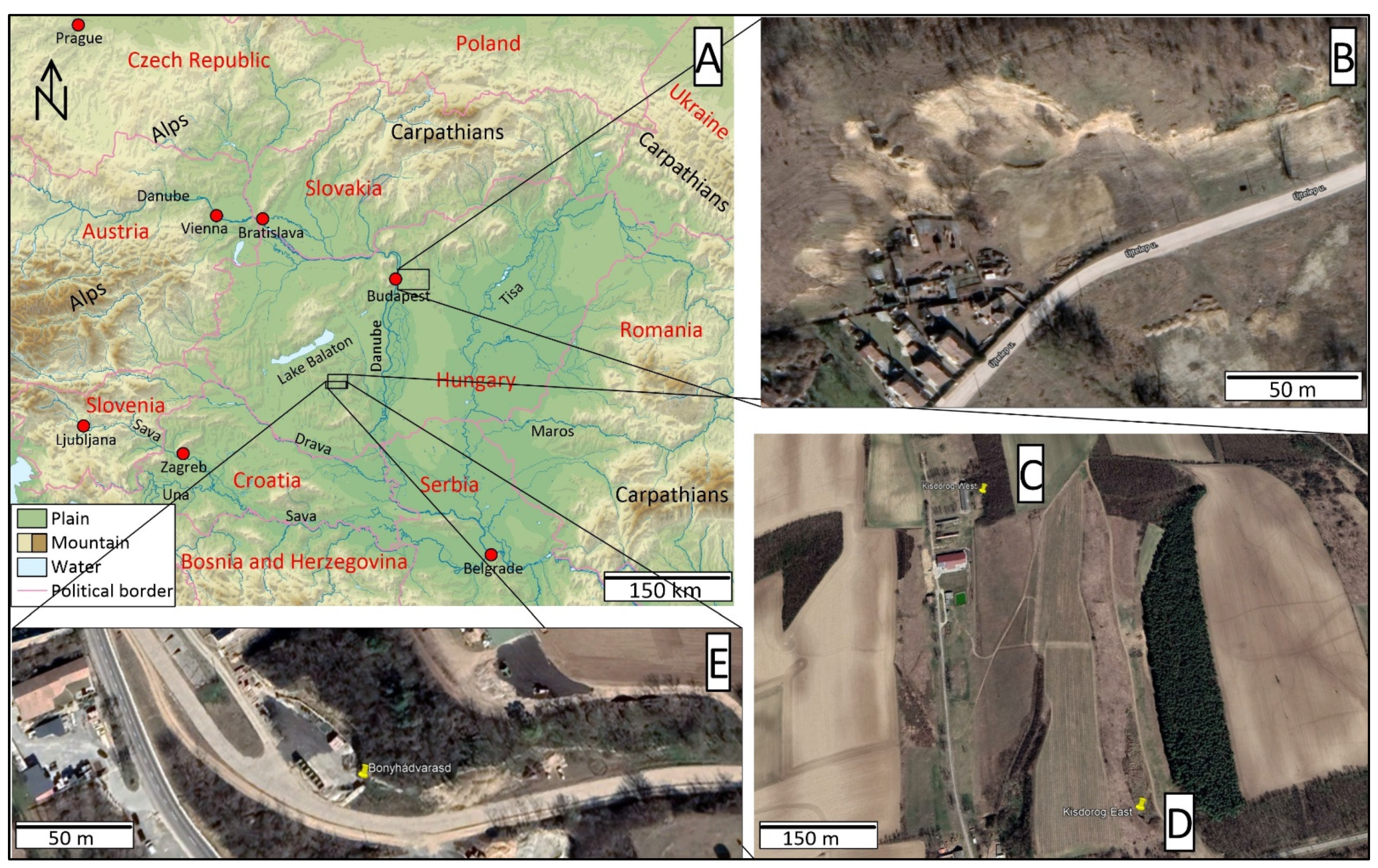
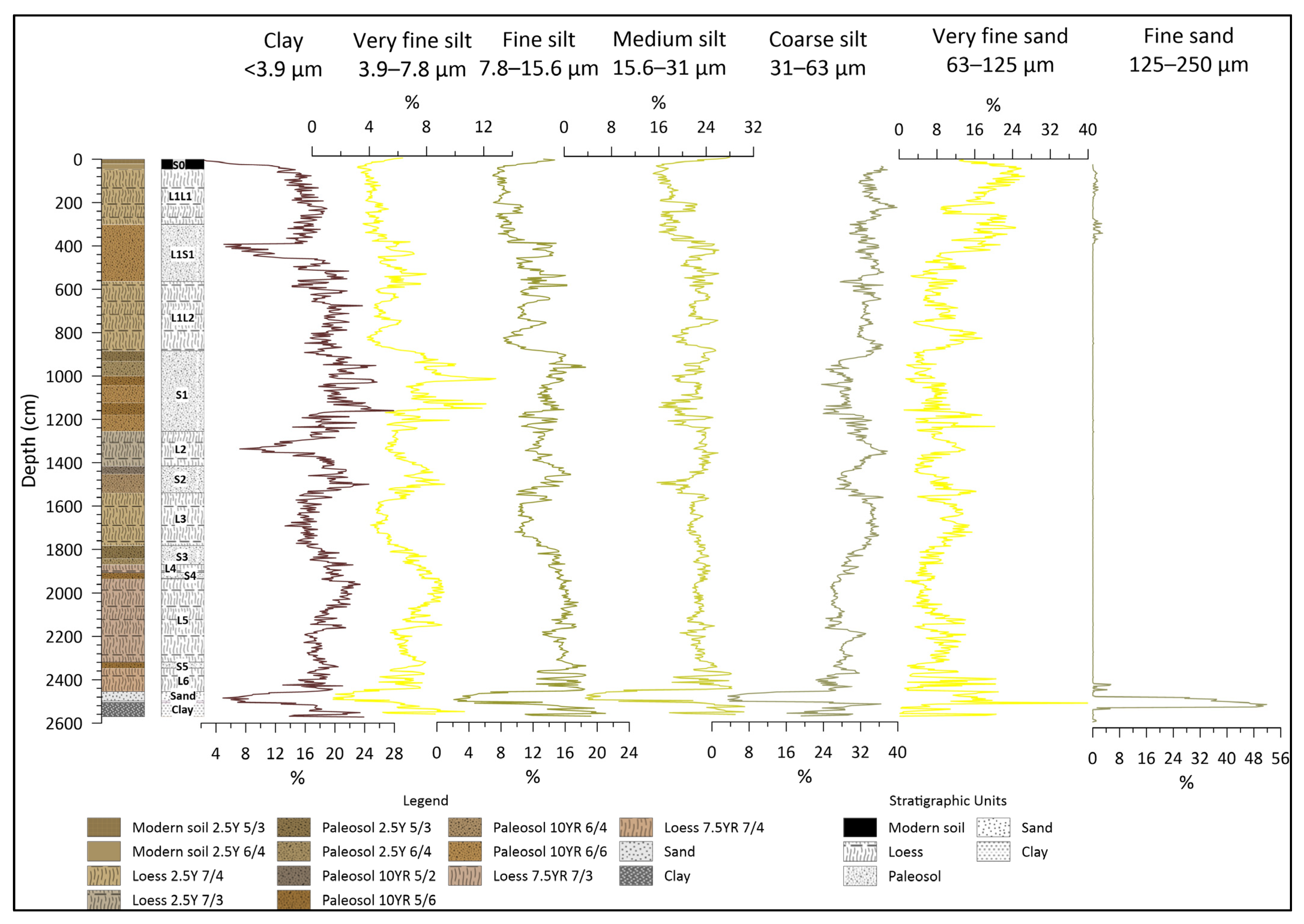
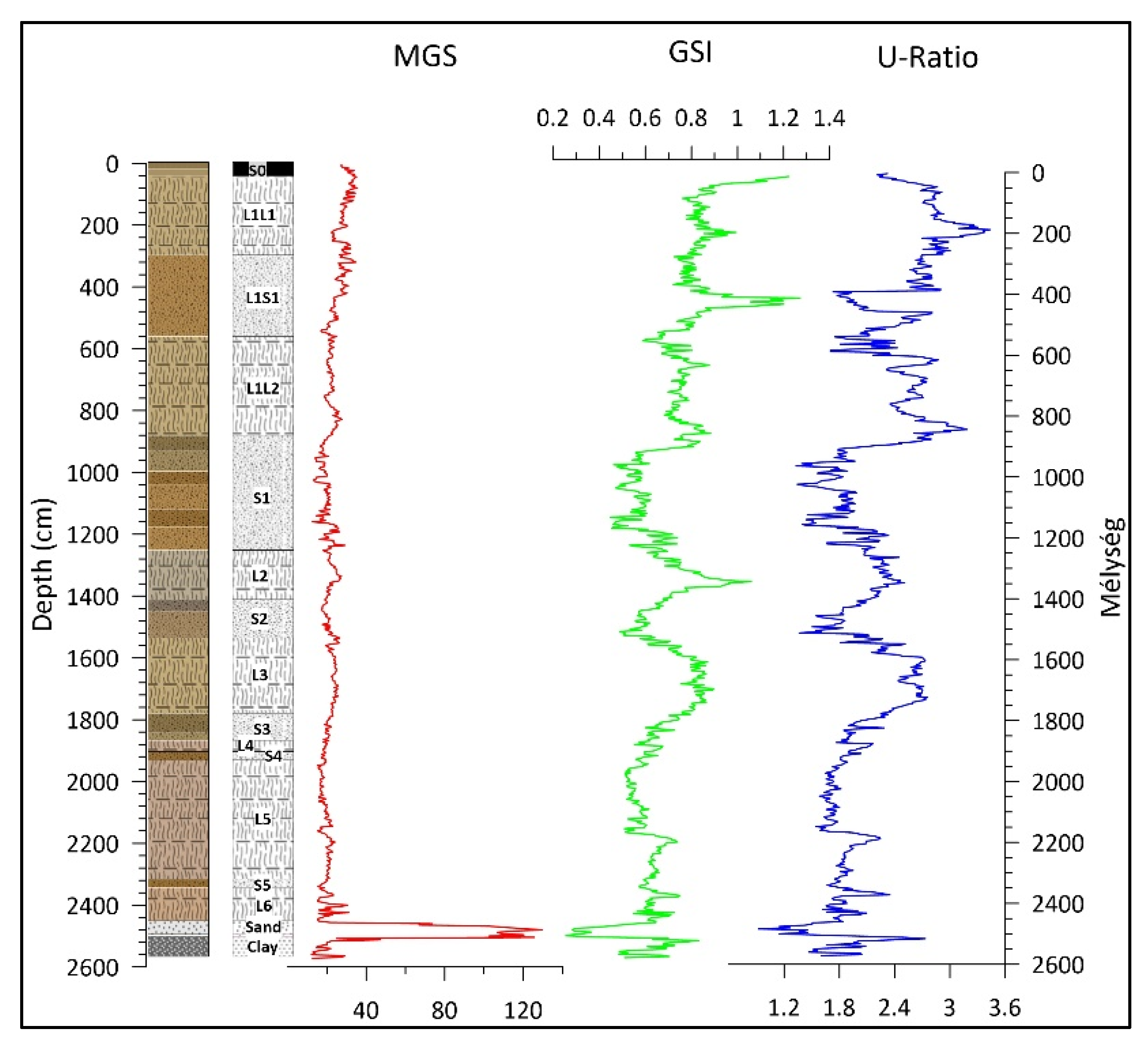
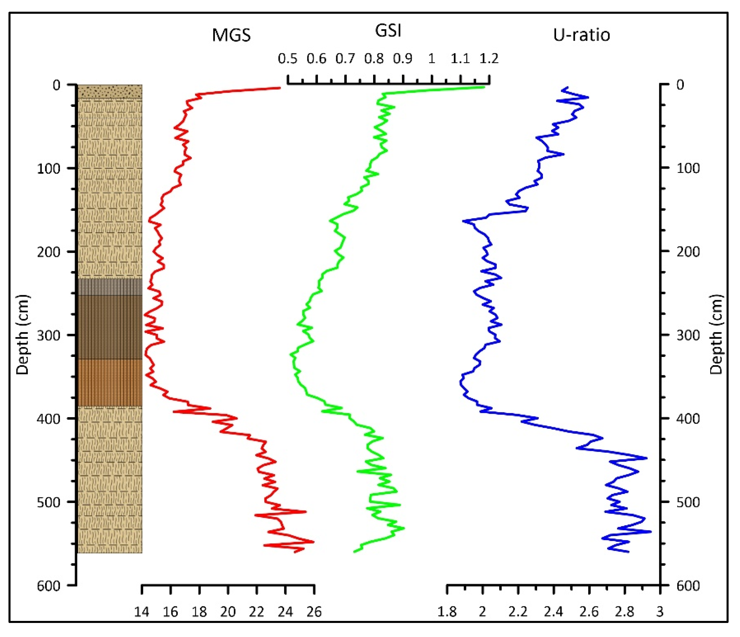
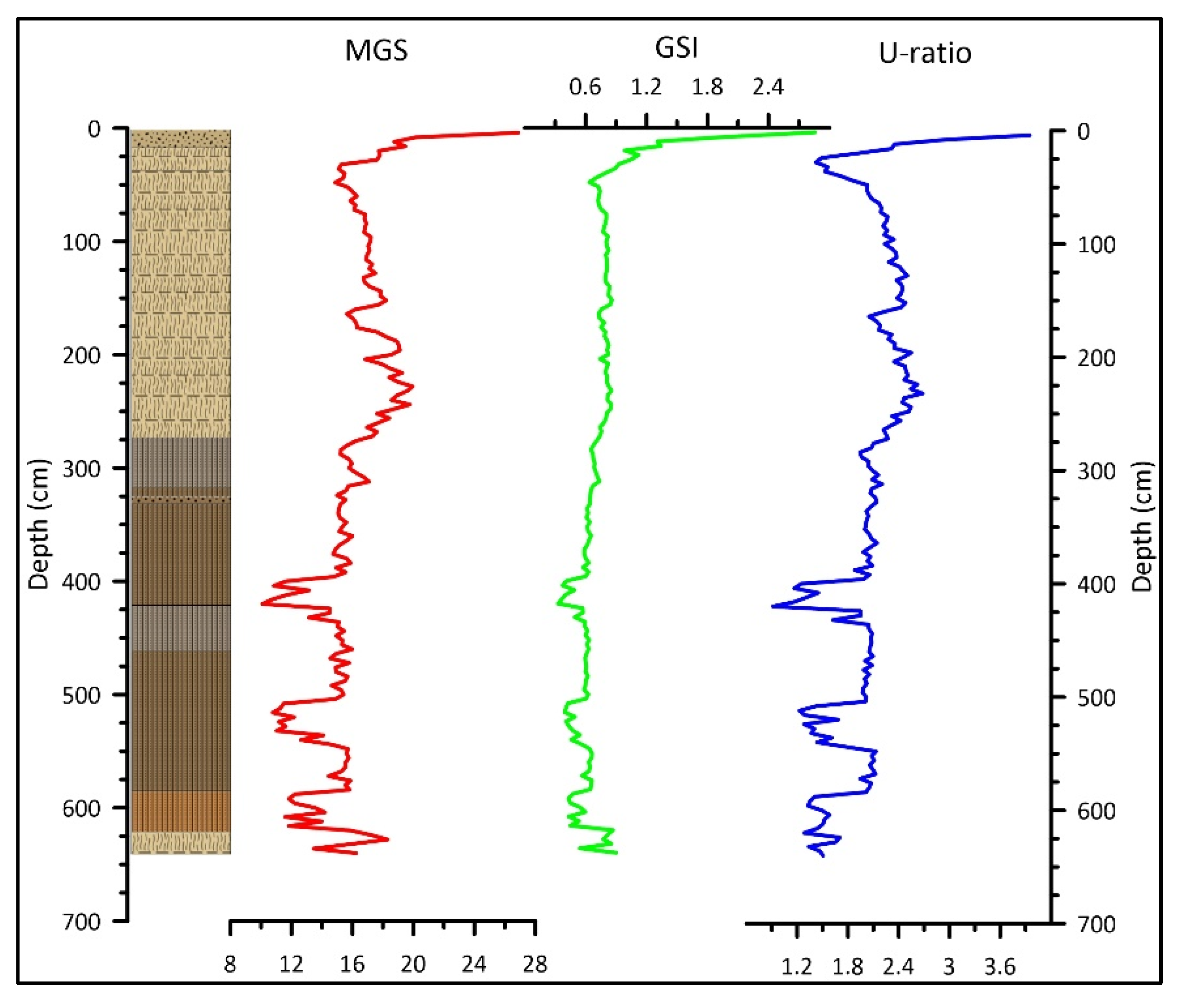
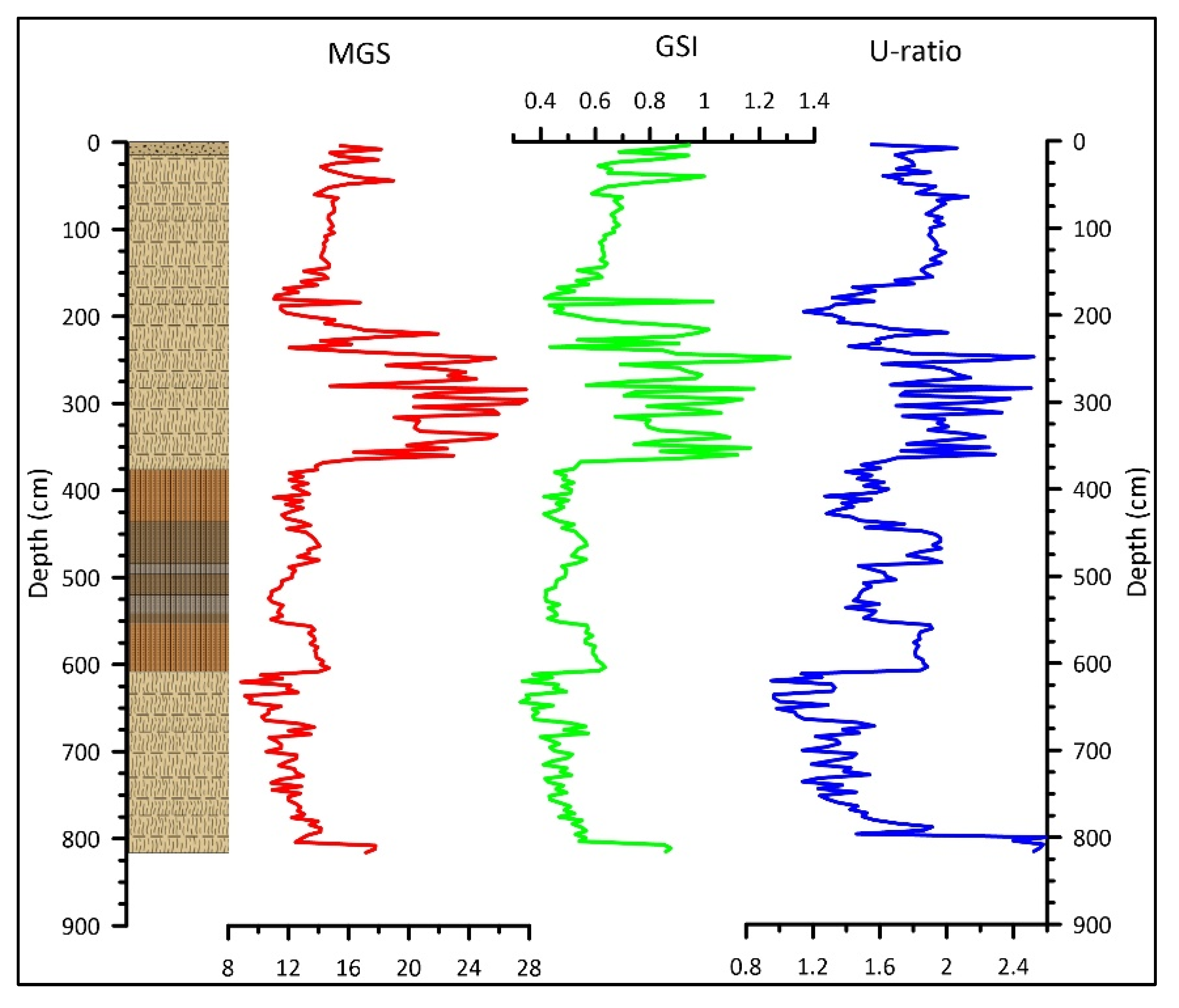
3.1. Profiles
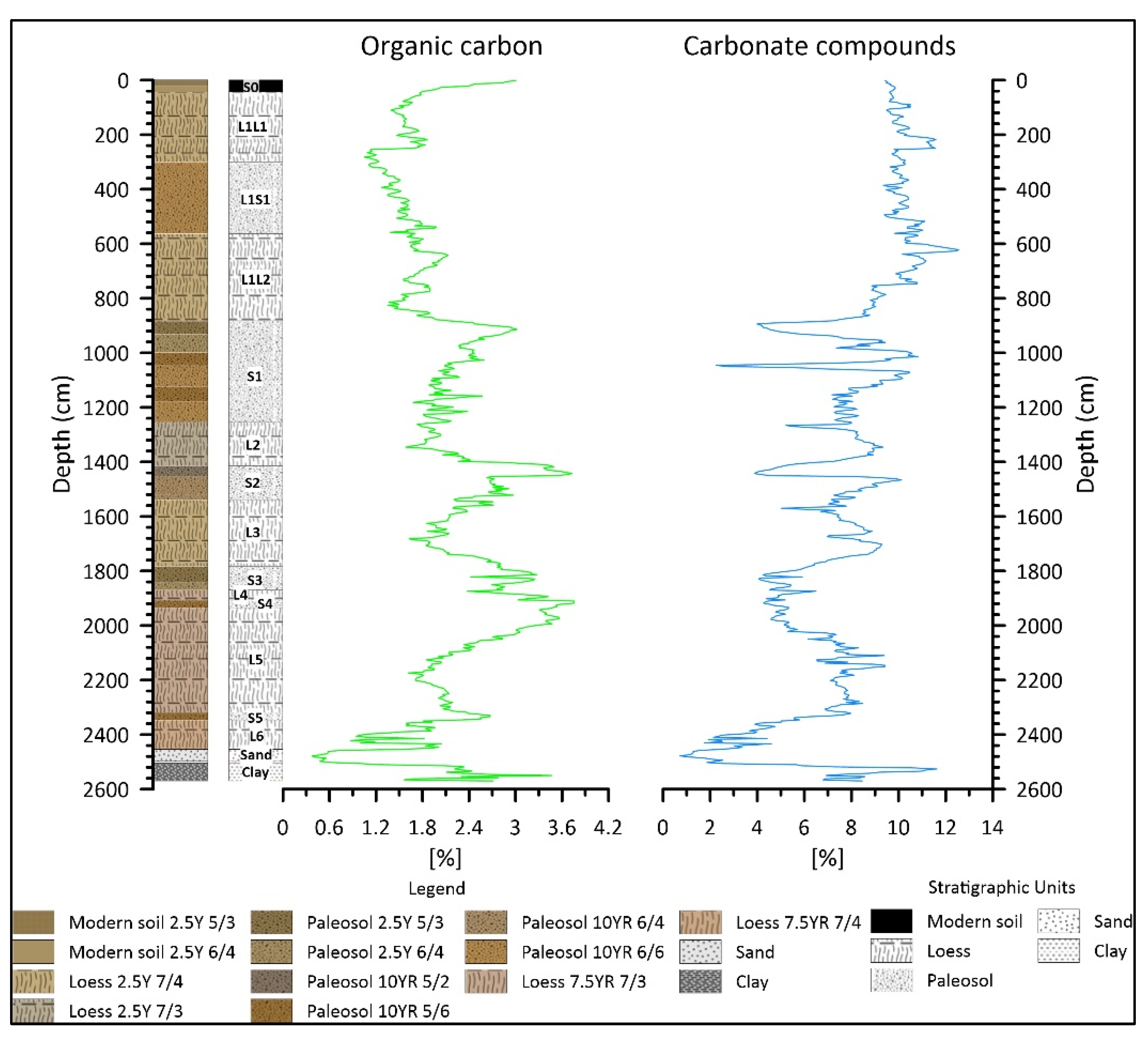
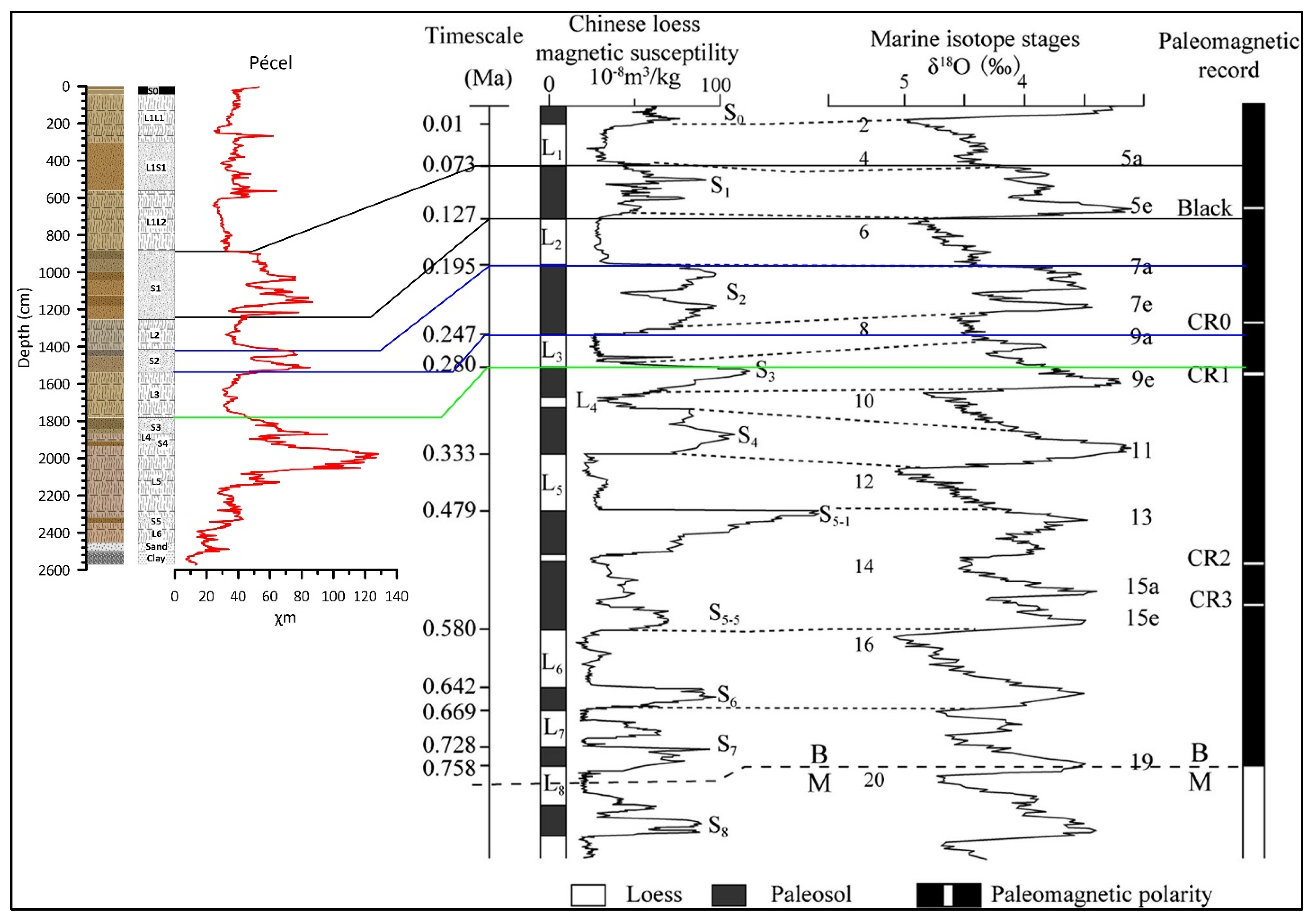
3.1.1. Pécel
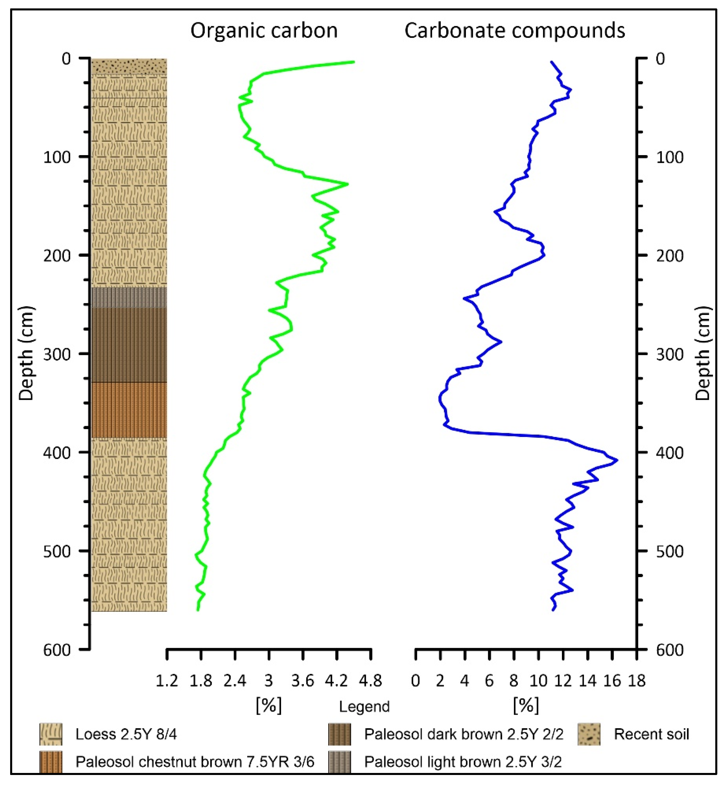
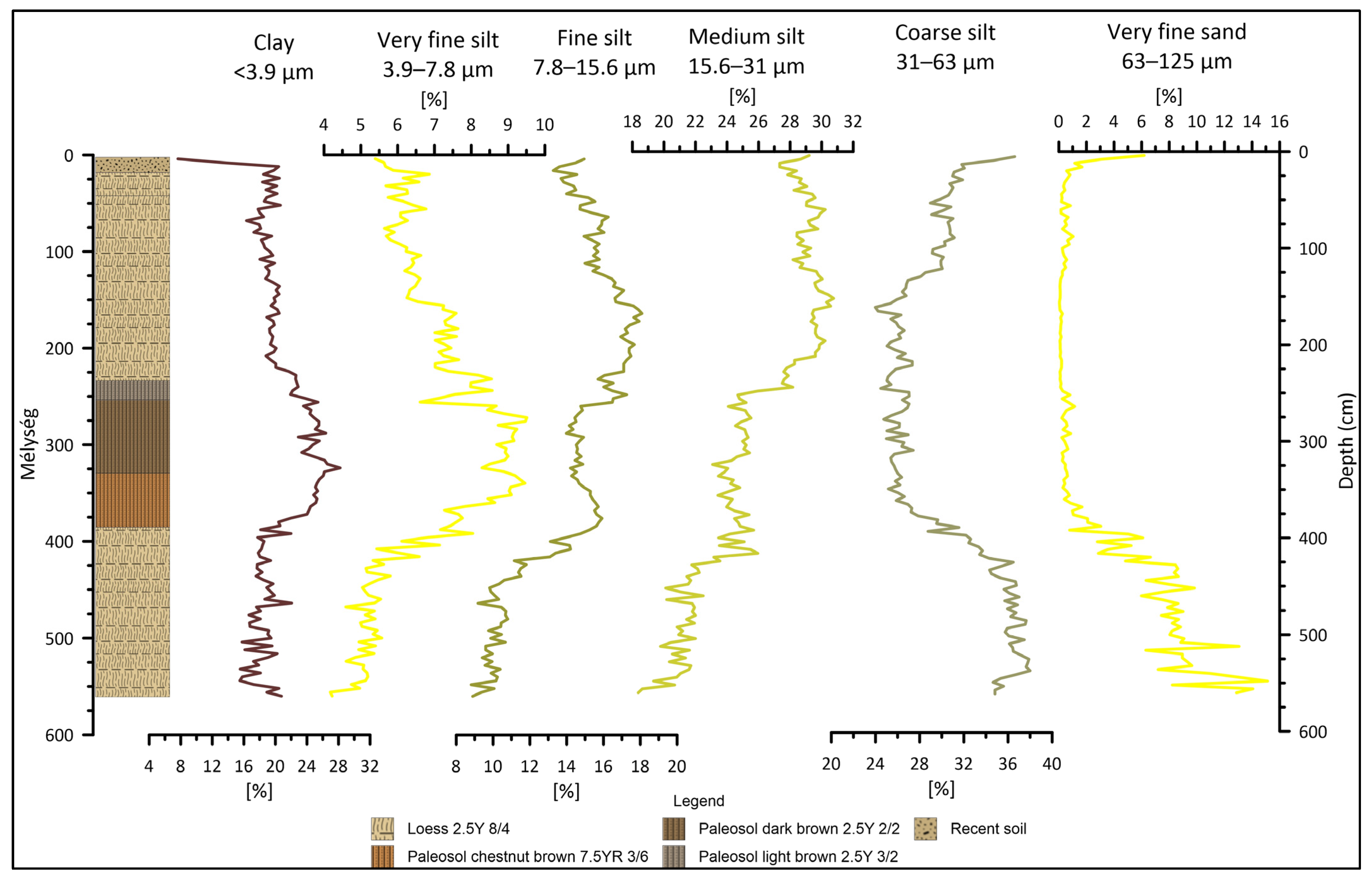
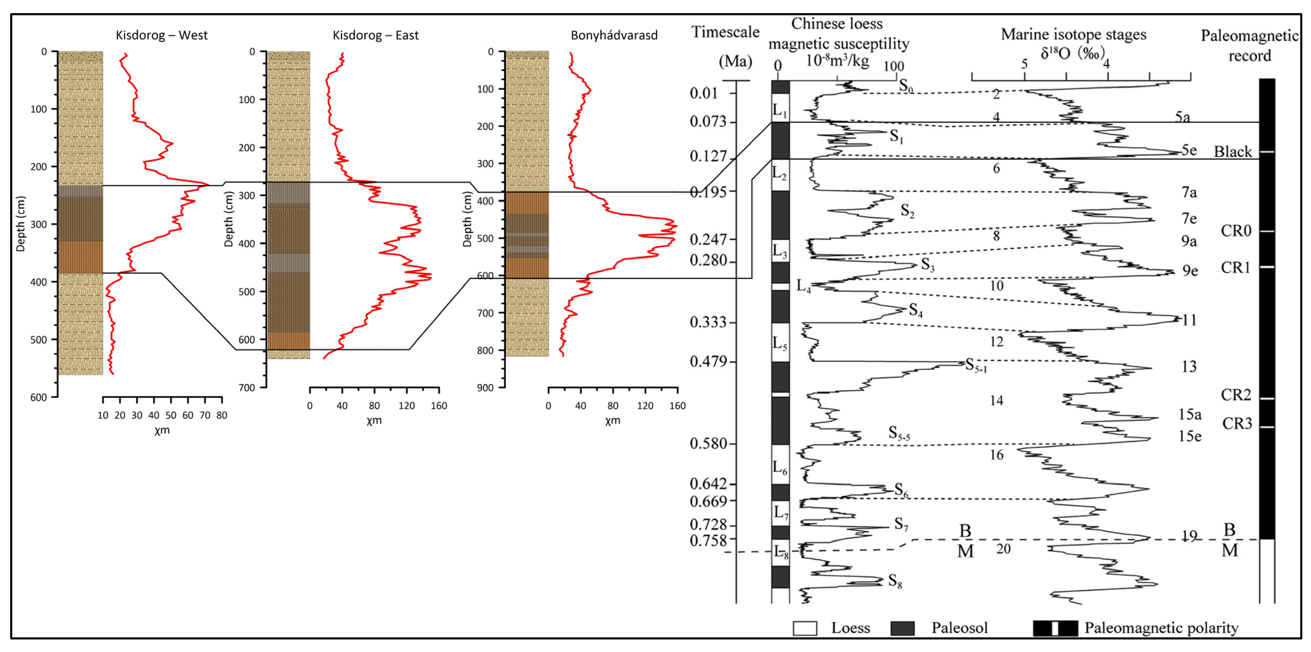
3.1.2. Kisdorog-West
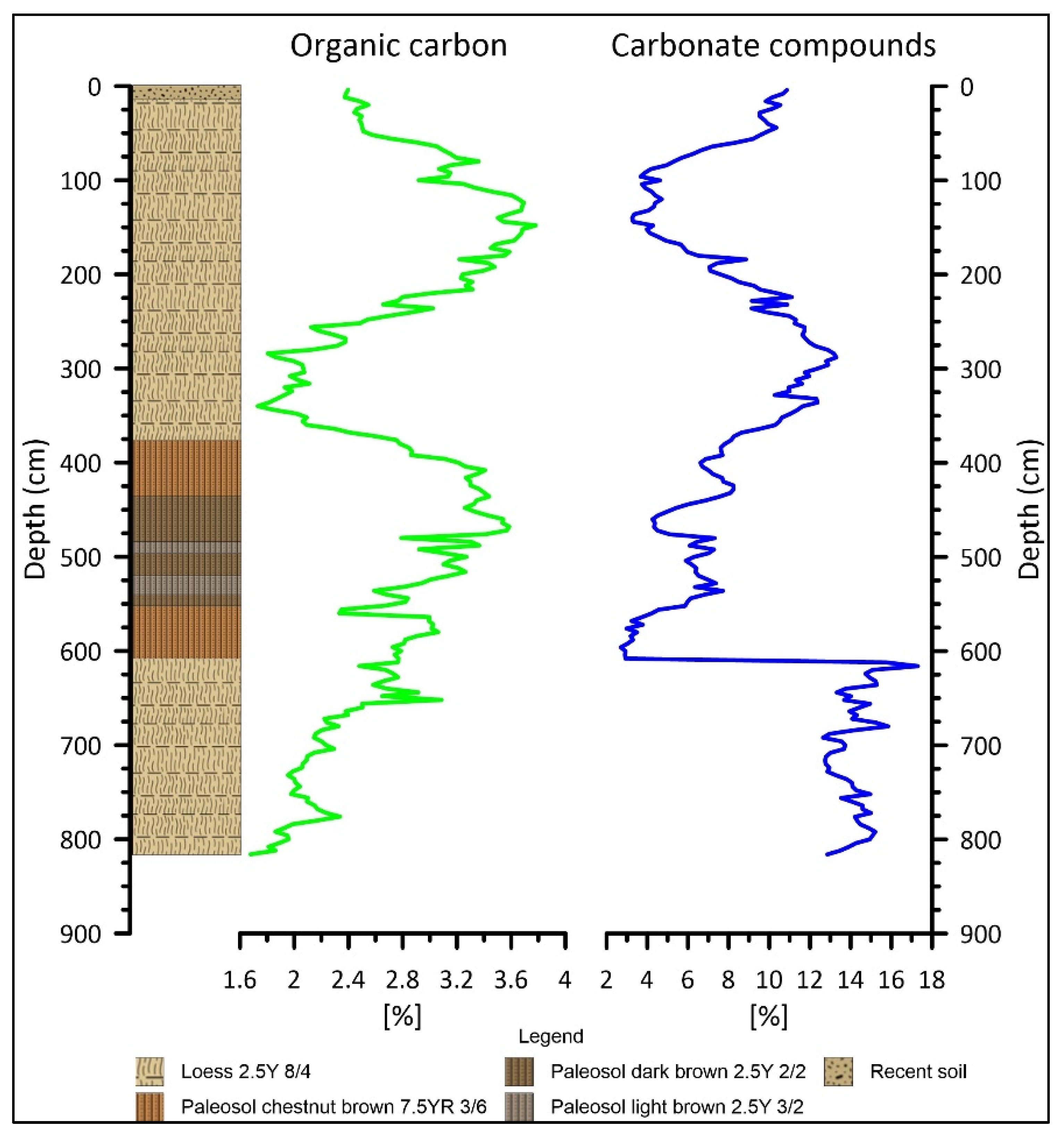
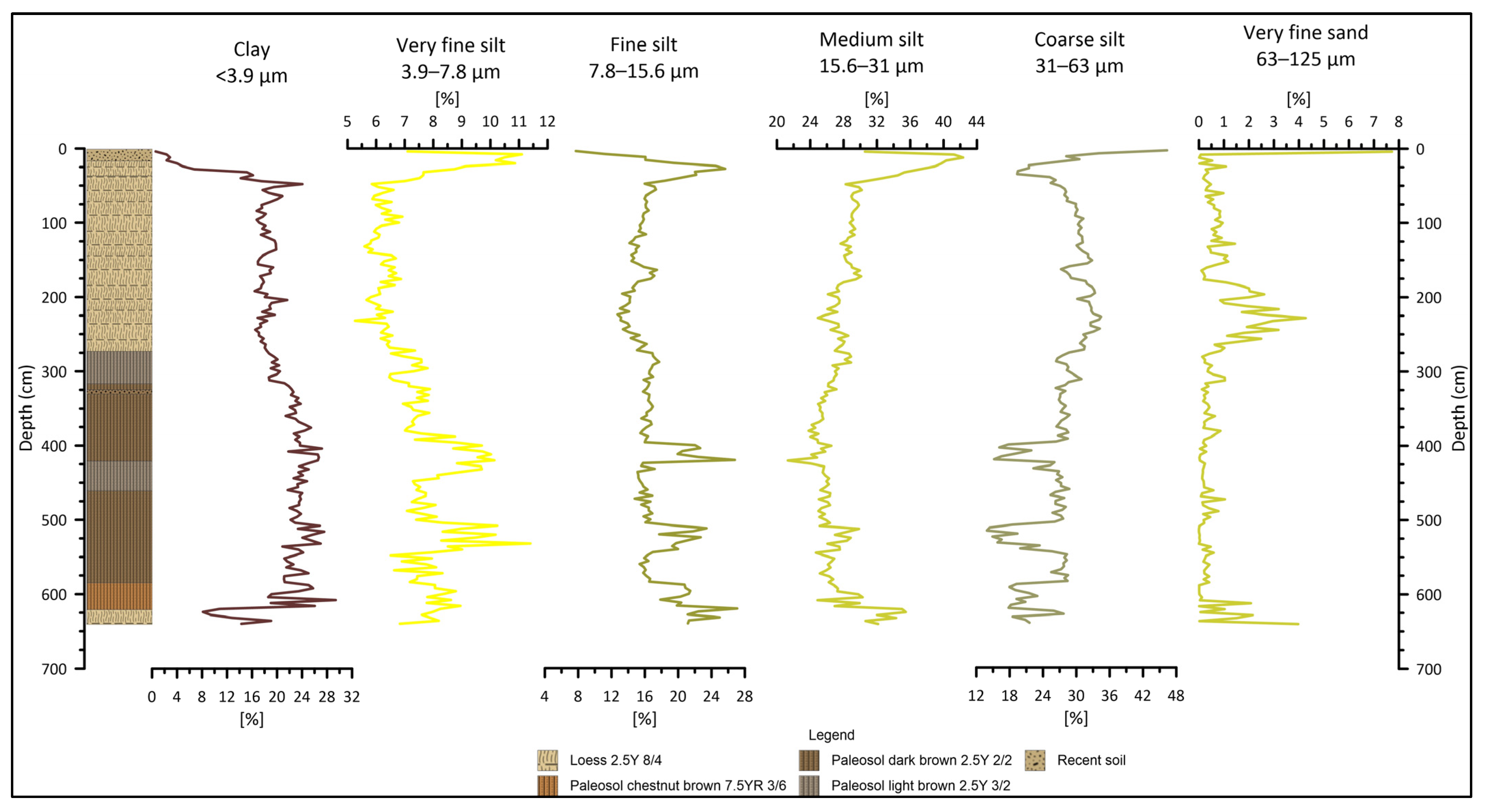
3.1.3. Kisdorog-East
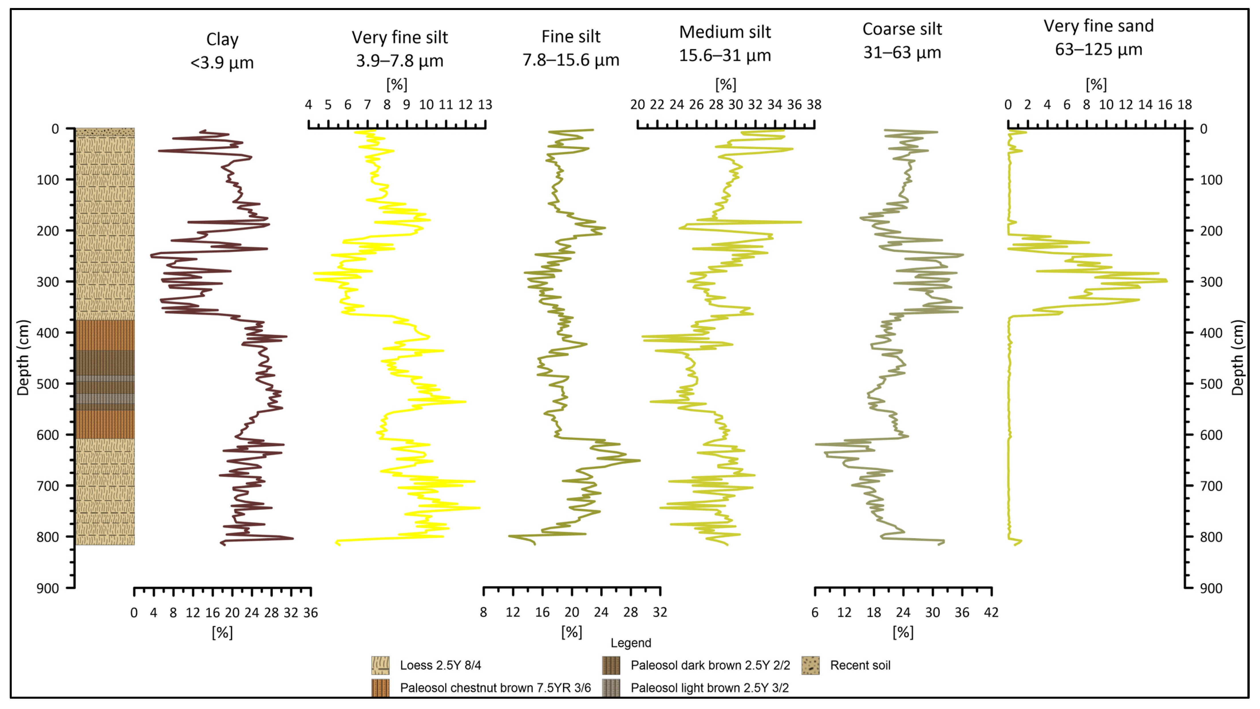
3.1.4. Bonyhádvarasd
3.2. LOI
3.2.1. Pécel
3.2.2. Kisdorog-West
3.2.3. Kisdorog-East
3.2.4. Bonyhádvarasd
3.3. Grain Size Distribution
3.3.1. Pécel
3.3.2. Kisdorog-West
3.3.3. Kisdorog-East
3.3.4. Bonyhádvarasd
3.4. Grain Size Indices
3.4.1. Pécel
3.4.2. Kisdorog-West
3.4.3. Kisdorog-East
3.4.4. Bonyhádvarasd
3.5. Magnetic Susceptibility
4. Discussion
4.1. Pécel
4.2. Kisdorog-West
4.3. Kisdorog-East
4.4. Bonyhádvarasd
5. Conclusions
5.1. Pécel
5.2. Transdanubian Profiles
Author Contributions
Funding
Data Availability Statement
Acknowledgments
Conflicts of Interest
References
- Dövényi, Z. Cserhát-Vidék in Magyarország Kistájainak Katasztere, 2nd ed.; MTA Földrajztudományi Kutatóintézet: Budapest, Hungary, 2010; pp. 705–708. [Google Scholar]
- Sümegi, P.; Gulyás, S.; Persaits, G.; GergelyPáll, D.; Molnár, D. The loess-paleosol sequence of Basaharc (Hungary) revisited: Mollusc-based paleoecological results for the Middle and Upper Pleistocene. Quat. Int. 2011, 240, 181–192. [Google Scholar] [CrossRef]
- Bösken, J.; Obreht, I.; Zeeden, C.; Klasen, N.; Hambach, U.; Sümegi, P.; Lehmkuhl, F. High-resolution paleclimatic proxy data from the MIS3/2 transition recorded in northeastern Hungarian loess. Quat. Int. 2019, 502, 95–107. [Google Scholar] [CrossRef]
- Sümegi, P.; Törőcsik, T.; Náfrádi, K.; Sümegi, B.P.; Majkut, P.; Molnár, D.; Tapody, R. Radiocarbon dated complex paleoecological and geoarcheological analyses at the Bodrogkeresztúr Henye Gravettian site (NE Hungary). Archeom. Műhely 2016, 8, 31–42. [Google Scholar]
- Makó, L.; Molnár, D.; Cseh, P.; Sümegi, P. MAR comparisons between different chronometric methods for two profiles in the Bodrogkeresztúr area. Stud. Quat. 2021, 38, 67–73. [Google Scholar]
- Varga, A.; Újvári, G.; Raucsik, B. Tectonic versus climatic control on the evolution of a loess-paleosol sequence at Beremend, Haungary: An integrated approach based on paleoecological, clay mineralogical, and geochemical data. Quat. Int. 2011, 240, 71–86. [Google Scholar] [CrossRef]
- Dövényi, Z. Mecsek és Tolna-Baranyai-Dombvidék in Magyarország Kistájainak Katasztere, 2nd ed.; MTA Földrajztudományi Kutatóintézet: Budapest, Hungary, 2010; pp. 500–503. [Google Scholar]
- Sümegi, P.; Náfrádi, K.; Molnár, D.; Sávai, S. Results of paleoecological studies in the loess region of Szeged-Öthalom (SE Hungary). Quat. Int. 2015, 372, 66–78. [Google Scholar] [CrossRef]
- Sümegi, P.; Molnár, D.; Gulyás, S.; Náfrádi, K.; Sümegi, B.P.; Törőcsik, T.; Persaits, G.; Molnár, M.; Vandenberghe, J.; Zhou, L. High-resolution proxy record of the environmental response to climatic variations during transition MIS3/MIS2 and MIS2 in Central Europe: The loess-paleosol sequence of Katymár brickyard (Hungary). Quat. Int. 2019, 504, 40–55. [Google Scholar] [CrossRef]
- Sümegi, P.; Gulyás, S.; Molnár, D.; Szilágyi, G.; Sümegi, B.P.; Törőcsik, T.; Molnár, M. 14C Dated Chronology of the Thickest and Best Resolved Loess/Paleosol Record of the LGM from SE Hungary Based on Comparing Precision and Accuracy of Age-Depth Models. Radiocarbon 2020, 62, 403–417. [Google Scholar] [CrossRef]
- Molnár, D.; Sümegi, P.; Makó, L.; Cseh, P.; Zeeden, C.; Nett, J.; Lehmkuhl, F.; Törőcsik, T.; Sümegi, B.P. Palaeoecological background of the Upper Palaeolithic site of Ságvár, Hungary: Radiocarbon-dated malacological and sedimentological studies on the Late Pleistocene environment. J. Quat. Sci. 2021, 36, 1353–1363. [Google Scholar] [CrossRef]
- Sümegi, P.; Gulyás, S.; Molnár, D.; Bozsó, G.; Fekete, I.; Makó, L.; Cseh, P.; Molnár, M.; Sümegi, B.P.; Almond, P.; et al. New chronology and extended palaeoenvironmental data to the 1975 loess profile of Madaras brickyard, South Hungary. J. Quat. Sci. 2021, 36, 1364–1381. [Google Scholar] [CrossRef]
- Molnár, D.; Makó, L.; Sümegi, P.; Sümegi, B.P.; Törőcsik, T. Revisiting the palaeolithic site at Szeged-Öthalom: Attempt for appoint the palaeolithic horizon. Stud. Quat. 2019, 36, 45–53. [Google Scholar]
- Újvári, G.; Varga, A.; Raucsik, B.; Kovács, J. The Paks loess-paleosol sequence: A record of chemical weathering and provenance for the last 800ka in the mid-Carpathian Basin. Quat. Int. 2014, 319, 22–37. [Google Scholar] [CrossRef]
- Újvári, G.; Molnár, M.; Páll-Gergely, B. Charcoal and mollusc shell 14 C-dating of the Dunaszekcső loess record, Hungary. Quat. Geochronol. 2016, 35, 43–53. [Google Scholar] [CrossRef]
- Buggle, B.; Glaser, B.; Zöller, L.; Hambach, U.; Marković, S.B.; Glaser, I.; Gerasimenko, N. Geochemical characterization and origin of Southeastern and Eastern European loesses (Serbia, Romania, Ukraine). Quat. Sci. Rev. 2008, 27, 1058–1075. [Google Scholar] [CrossRef]
- Marković, S.B.; Bokhorst, M.P.; Vandenberghe, J.; McCoy, W.D.; Oches, E.A.; Hambach, U.; Gaudenyi, T.; Jovanović, M.; Zöller, L.; Stevens, T.; et al. Late Pleistocene loess-palaeosol sequences in the Vojvodina region, north Serbia. J. Quat. Sci. 2008, 23, 73–84. [Google Scholar] [CrossRef]
- Marković, S.B.; Stevens, T.; Kukla, G.J.; Hambach, U.; Fitzsimmons, K.E.; Gibbard, P.; Buggle, B.; Zech, M.; Guo, Z.; Hao, Q.; et al. Danube loess stratigraphy—Towards a pand-European loess stratigraphic model. Earth-Sci. Rev. 2015, 148, 228–258. [Google Scholar] [CrossRef]
- Galović, L.; Frechen, M.; Halamić, J.; Durn, G.; Romić, M. Loess chronostratigraphy in Eastern Croatia—A luminescence dating approach. Quat. Int. 2009, 198, 85–97. [Google Scholar] [CrossRef]
- Molnár, D.; Hupuczi, J.; Galović, L.; Sümegi, P. Preliminary malacological investigation on the loess profile at Zmajevac, Croatia. Open Geosci. 2010, 2, 52–56. [Google Scholar] [CrossRef]
- Molnár, D.; Makó, L.; Cseh, P.; Sümegi, P.; Fekete, I.; Galović, L. Middle and Late Pleistocene loess-palaeosol archives in East Croatia: Multi-proxy palaeoecological studies on Zmajevac and Šarengrad II sequences. Stud. Quat. 2021, 38, 3–17. [Google Scholar]
- Makó, L.; Molnár, D.; Runa, B.; Bozsó, G.; Cseh, P.; Nagy, B.; Sümegi, P. Selected Grain-Size and Geochemical Analyses of the Loess-Paleosol Sequence of Pécel (Northern Hungary): An Attempt to Determine Sediment Accumulation Conditions and the Source Area Location. Quaternary 2021, 4, 17. [Google Scholar] [CrossRef]
- Koloszár, L.; Marsi, I. The thickest and the most complete loess sequence in the Carpathian Basin: The section of the borehole Udvari-2A and its significance in the Quaternary stratigraphy (in Hungarian). Földtani Közlöny 2010, 140, 251–262. [Google Scholar]
- Sümegi, P.; Gulyás, S.; Molnár, D.; Sümegi, B.P.; Almond, P.C.; Vandenberghe, J.; Zhou, L.; Pál-Molnár, E.; Törőcsik, T.; Hao, Q.; et al. New chronology of the best developed loess/paleosol sequence of Hungary capturing the past 1.1 ma: Implications for correlation and proposed pan-Eurasian stratigraphic schemes. Quat. Sci. Rev. 2018, 191, 144–166. [Google Scholar] [CrossRef]
- Wikimedia Commons. Pannonian Basin Geographic Map Blank Cropped. Available online: https://upload.wikimedia.org/wikipedia/commons/2/27/Pannonian_Basin_geographic_map_blank_croped.svg (accessed on 15 May 2021).
- Sümegi, P.; Hertelendi, E. Reconstruction of microenvironmental changes in Kopasz Hill loess area at Tokaj (Hungary) between 15,000–70,000 BP years. Radiocarbon 1998, 40, 855–863. [Google Scholar] [CrossRef]
- Munsell Color (Firm). Munsell Soil Color Charts: With Genuine Munsell Color Chips; Munsell Color: Grand Rapids, MI, USA, 2010. [Google Scholar]
- Nettleton, W.D.; Brasher, B.R.; Benham, E.C.; Ahrens, R.J. A classification system for buried paleosols. Quat. Int. 1998, 51–52, 175–183. [Google Scholar] [CrossRef]
- Kraus, M.J. Paleosols in clastic sedimentary rocks: Their geologic applications. Earth-Sci. Rev. 1999, 47, 41–70. [Google Scholar] [CrossRef]
- Krasilnikov, P.; García Calderón, N.E. A WRB-based buried paleosol classification. Quat. Int. 2006, 156–157, 176–188. [Google Scholar] [CrossRef]
- Dean, W.E. Determination of carbonate and organic matter in calcareous sediments and sedimentary rocks by loss on ignition; comparison with other methods. J. Sediment. Res. 1974, 44, 242–248. [Google Scholar] [CrossRef]
- Heiri, O.; Lotter, A.F.; Lemcke, G. Loss on ignition as a method for estimating organic and carbonate content in sediments: Reproducibility and comparability of results. J. Paleolimnol. 2001, 25, 101–110. [Google Scholar] [CrossRef]
- Bokhorst, M.P.; Vandenberghe, J.; Sümegi, P.; Łanczont, M.; Gerasimenko, N.P.; Matviishina, Z.N.; Marković, S.B.; Frechen, M. Atmospheric circulation patterns in central and eastern Europe during Weichselian Pleniglacial inferred from loess grain-size records. Quat. Int. 2011, 234, 62–74. [Google Scholar] [CrossRef]
- Wentworth, C.K. A scale of grade and class terms for clastic sediments. J. Geol. 1922, 30, 377–392. [Google Scholar] [CrossRef]
- Vandenberghe, J.; Mucher, H.J.; Roebroeks, W.; Gemke, D. Lithostratigraphy and Paleoenvironment of the Pleistocene Deposits at Maastricht-Belvédère, Southern Limburg, the Netherlands in Maastricht-Belvédère: Stratigraphy, Palaeoenvironment and Archaeology of the Middle and Late Pleistocene Deposits. Analecta Praehist. Leiden. 1985, 18, 7–18. [Google Scholar]
- Vandenberghe, J.; An, Z.S.; Nugteren, G.; Lu, H.; van Huissteden, K. New absolute time scale for Quaternary climate in the Chinese Loess region by grain-size analysis. Geology 1997, 25, 35–38. [Google Scholar] [CrossRef]
- Vandenberghe, J.; Nugteren, G. Rapid climatic changes recorded in loess successions. Glob. Planet. Chang. 2001, 28, 1–9. [Google Scholar] [CrossRef]
- Nugteren, G.; Vandenberghe, J.; van Huissteden, K.; An, Z.S. A Quaternary climate record based on grain size analysis from the Luochuan loess section on the Central Loess Plateau, China. Glob. Planet. Chang. 2004, 41, 167–183. [Google Scholar] [CrossRef]
- Vandenberghe, J. Grazin size of fine-grained windblown sediment: A powerful proxy for process identification. Earth-Sci. Rev. 2013, 121, 18–30. [Google Scholar] [CrossRef]
- Rousseau, D.; Antoine, P.; Hatté, C.; Lang, A.; Zöller, L.; Fontugne, M.; Othman, D.; Luck, J.; Moine, O.; Labonne, M.; et al. Abrupt millennial climatic changes from Nussloch (Germany) Upper Weichselian eolian records during the Last Glaciation. Quat. Sci. Rev. 2002, 21, 1577–1582. [Google Scholar] [CrossRef]
- Rousseau, D.-D.; Sima, A.; Antoine, P.; Hatté, C.; Lang, A.; Zöller, L. Link between European and North Atlantic abrupt climate changes over the last glaciation. Geophys. Res. Lett. 2007, 34, 22713. [Google Scholar] [CrossRef]
- Újvári, G.; Kok, J.F.; Varga, G.; Kovács, J. The physics of wind-blown loess: Implications for grain size proxy interpretations in Quaternary paleoclimate studies. Earth-Sci. Rev. 2016, 154, 247–278. [Google Scholar] [CrossRef]
- Zhou, L.P.; Oldfield, F.; Wintle, A.G.; Robinson, S.G.; Wang, J.T. Partly pedogenic origin of magnetic variations in Chinese loess. Nature 1990, 346, 737–739. [Google Scholar] [CrossRef]
- An, Z.; Kukla, G.J.; Porter, S.C.; Xiao, J. Magnetic Susceptibility Evidence of Monsoon Variation on the Loess Plateau of Central China during the last 130,000 Years. Quat. Res. 1991, 36, 29–36. [Google Scholar] [CrossRef]
- Rousseau, D.D.; Kukla, G. Late Pleistocene Climate Record in the Eustis Loess Section, Nebraska, Based on Land Snail Assemblages and Magnetic Susceptibility. Quat. Res. 1994, 42, 176–187. [Google Scholar] [CrossRef]
- Dearing, J.A.; Hay, K.L.; Baban, S.M.J.; Huddleston, A.S.; Wellington, E.M.H.; Loveland, P.J. Magnetic susceptibility of soil: An evaluation of conflicting theories using a national data set. Geophys. J. Int. 1996, 127, 728–734. [Google Scholar] [CrossRef]
- Sun, J.; Liu, T. Multiple origins and interpretations of the magnetic susceptibility signal in Chinese wind-blown sediments. Earth Planet. Sci. Lett. 2000, 180, 287–296. [Google Scholar] [CrossRef]
- Zhu, R.; Liu, Q.; Jackson, M.J. Paleoenvironmental significance of the magnetic fabrics in Chinese loess-paleosols since the last interglacial (<130 ka). Earth Planet. Sci. Lett. 2004, 221, 55–69. [Google Scholar]
- Hlavatskyi, D.; Bakhmutov, V. Early-Middle Pleistocene Magnetostratigraphic and Rock Magnetic Records of the Dolynske Section (Lower Danube, Ukraine) and Their Applications to the Correlation of Loess-Palaeosol Sequences in Eastern and South-Eastern Europe. Quaternary 2021, 4, 43. [Google Scholar] [CrossRef]
- Chen, J.; Chen, Y.; Liu, L.; Ji, J.; Balsam, W.; Sun, Y.; Lu, H. Zr/Rb ratio in the Chinese loess sequence and its implication for changes in the East Asian winter monsoon strength. Geochem. Cosmochim. Acta 2006, 70, 1471–1482. [Google Scholar] [CrossRef]
- Kukla, G. Loess stratigraphy in central China. Quat. Sci. Rev. 1987, 6, 191–219. [Google Scholar] [CrossRef]
- Kukla, G.; An, Z. Loess stratigraphy in Central China. Palaeogeogr. Palaeoclimatol. Palaeoecol. 1989, 72, 203–225. [Google Scholar] [CrossRef]
- Kukla, G.; An, Z.S.; Melice, J.L.; Gavin, J.; Xiao, J.L. Magnetic susceptibility record of Chinese Loess. Trans. R. Soc. Edinb. Earth Sci. 1990, 81, 263–288. [Google Scholar] [CrossRef]
- Pye, K. The nature, origin and accumulation of loess. Quat. Sci. Rev. 1995, 14, 653–667. [Google Scholar] [CrossRef]
- Ren, J.; Zhang, S.; Meigs, A.J.; Yeats, R.S.; Ding, R.; Shen, X. Tectonic controls for transverse drainage and timing of the Xin-Ding paleolake breach in the upper reach of the Hutuo River, north China. Geomorphology 2014, 206, 452–467. [Google Scholar] [CrossRef]


Disclaimer/Publisher’s Note: The statements, opinions and data contained in all publications are solely those of the individual author(s) and contributor(s) and not of MDPI and/or the editor(s). MDPI and/or the editor(s) disclaim responsibility for any injury to people or property resulting from any ideas, methods, instructions or products referred to in the content. |
© 2023 by the authors. Licensee MDPI, Basel, Switzerland. This article is an open access article distributed under the terms and conditions of the Creative Commons Attribution (CC BY) license (https://creativecommons.org/licenses/by/4.0/).
Share and Cite
Makó, L.; Cseh, P.; Nagy, B.; Sümegi, P.; Molnár, D. Development History of the Loess–Paleosol Profiles of Pécel, Kisdorog and Bonyhádvarasd, Hungary. Quaternary 2023, 6, 38. https://doi.org/10.3390/quat6030038
Makó L, Cseh P, Nagy B, Sümegi P, Molnár D. Development History of the Loess–Paleosol Profiles of Pécel, Kisdorog and Bonyhádvarasd, Hungary. Quaternary. 2023; 6(3):38. https://doi.org/10.3390/quat6030038
Chicago/Turabian StyleMakó, László, Péter Cseh, Balázs Nagy, Pál Sümegi, and Dávid Molnár. 2023. "Development History of the Loess–Paleosol Profiles of Pécel, Kisdorog and Bonyhádvarasd, Hungary" Quaternary 6, no. 3: 38. https://doi.org/10.3390/quat6030038
APA StyleMakó, L., Cseh, P., Nagy, B., Sümegi, P., & Molnár, D. (2023). Development History of the Loess–Paleosol Profiles of Pécel, Kisdorog and Bonyhádvarasd, Hungary. Quaternary, 6(3), 38. https://doi.org/10.3390/quat6030038