
Research on the AHP–EWM–VIKOR Model and Comprehensive Evaluation Method for Selecting Sites for Artificial Caverns in CAES

Abstract
1. Introduction
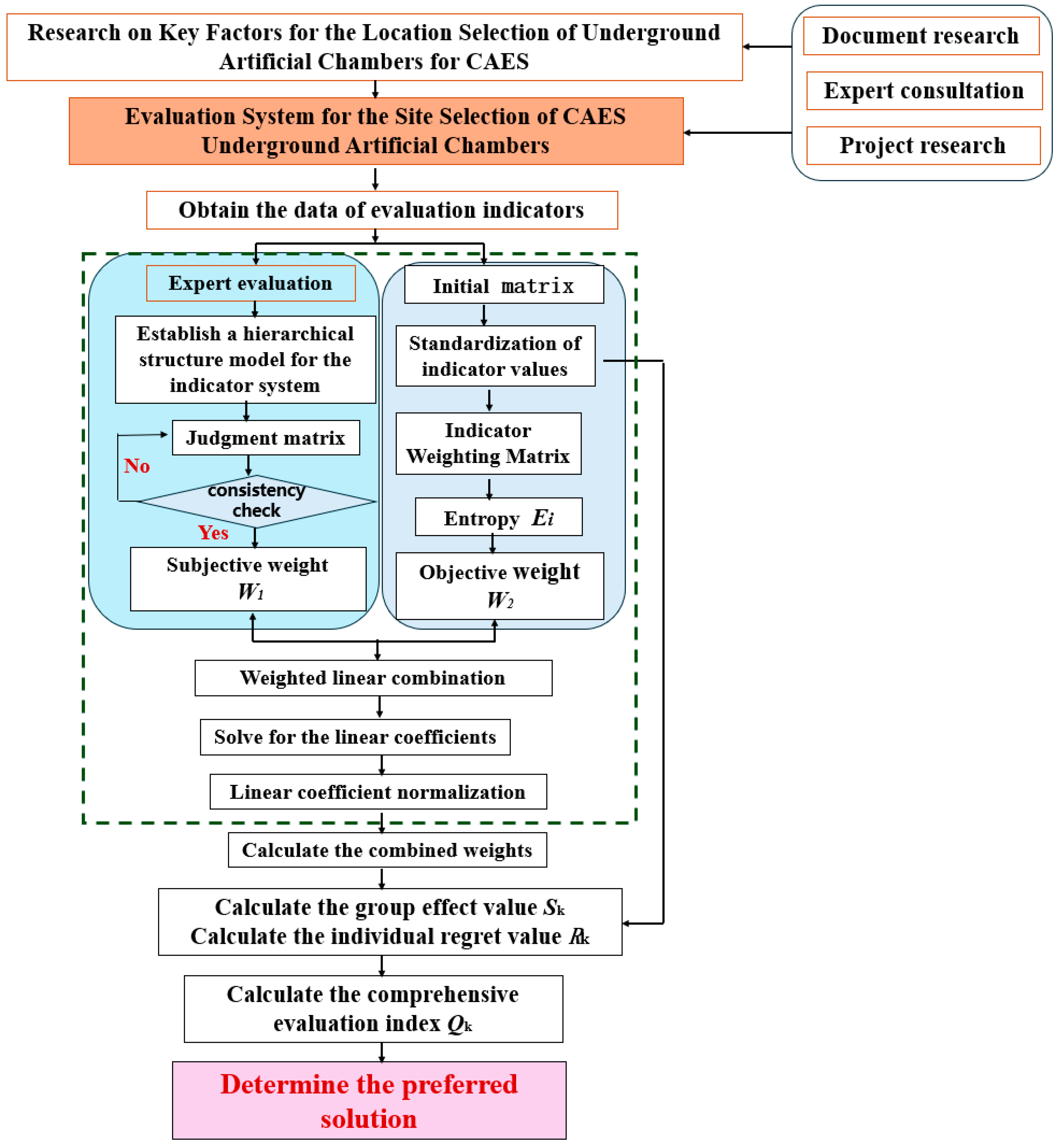
2. Evaluation Index System for Site Selection of Underground Artificial Caverns for CAES
2.1. Key Factors in Site Selection for Underground Cavern Storage of CAES
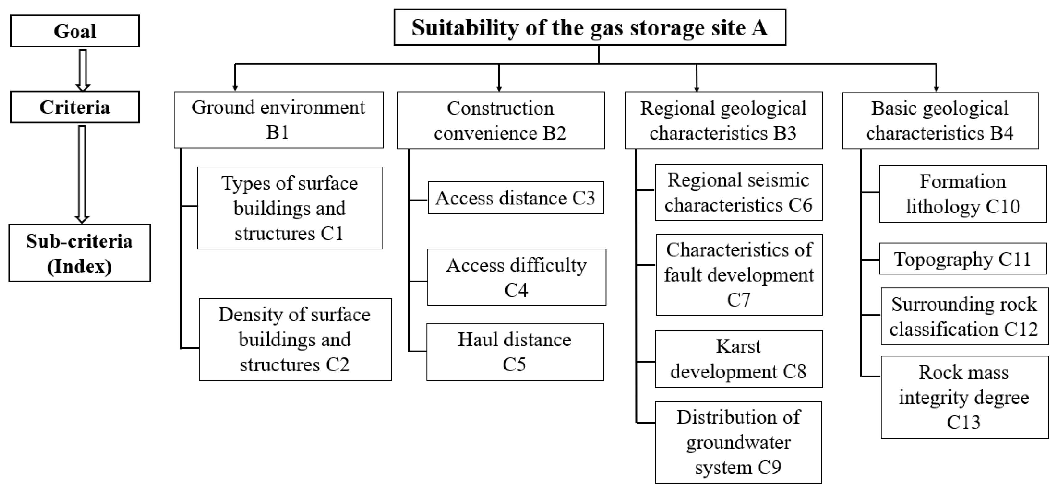
2.2. Formulation of the Comprehensive Indicator System
- (1)
- Ground Environment (B1)
- (2)
- Construction Convenience (B2)
- (3)
- Regional Geological Characteristics (B3)
- (4)
- Basic Geological Characteristics (B4) [1]
3. Comprehensive Evaluation of Site Selection Criteria for Underground Artificial Caverns in CAES Projects
3.1. Determination of Evaluation Indicator System Weights
3.1.1. Subjective Weighting in the Analytic Hierarchy Process (AHP)
3.1.2. Entropy Weighting Method (EWM) for Objective Weighting
- (1)
- Data standardization. Standardize the data for each indicator. For m evaluation schemes and n evaluation indicators, first establish the raw matrix . Standardize the raw matrix to obtain the standardized matrix , where represents the standardized value of the j-th evaluation scheme on the i-th indicator—standardization formula for positive indicators (where higher values indicate better quality).
- (2)
- Calculate the information entropy e of the indicators. The information entropy of the i-th indicator () is
- (3)
- Calculation of the difference coefficient: The difference coefficient for the i-th indicator is
- (4)
- Weight calculation: Determine the weight for the i-th indicator based on the coefficient of variation for each indicator.
3.1.3. Game-Theory-Based Combinatorial Weighting
- (1)
- Determine the weighting of each indicator.
- (2)
- Coefficient optimization. Based on game theory principles, the linear combination coefficients in Equation (10) are optimized to minimize the deviation of the linear combination , yielding the optimal . The corresponding optimal policy model is
- (3)
- Solve for the optimal combination. Based on the differential properties of matrices, the optimal first-order derivatives of Equation (11) can be converted into the following set of optimality conditions:
3.2. Site Selection Optimization for Underground Artificial Caverns of CAES Based on the VIKOR Method
- (1)
- Determine the positive and negative ideal solutions. For each indicator, identify the positive perfect solution and the negative ideal solution . The perfect solution is typically the maximum or minimum value of the indicator after data normalization, depending on the optimization direction of the indicator. Calculate the distance between each solution and the ideal solution: Use the norm and norm to compute the weighted distance between each solution and both the perfect solution and the negative ideal solution.
- (2)
- Calculate the comprehensive evaluation index . By comprehensively considering and , compute the comprehensive evaluation index for each scheme using the following formula:
- (3)
- Determine the preferred option. Based on the calculated results for , , and , sort them in ascending order. Site options ranked higher are preferred. Assuming Sort Order 1 and Sort Order 2 represent the top two alternatives sorted by , Sort Order 1 is deemed the optimal solution if it simultaneously satisfies the following two conditions:
4. Engineering Applications
4.1. Project Overview
4.2. AHP–EWM Weight Calculation
4.3. Determination of the Optimal Solution
4.3.1. Calculate S, R, Q
4.3.2. Robustness Evaluation
4.4. Model Comparison Analysis
4.4.1. Comparison of Results Based on the Weighted TOPSIS Method
4.4.2. Comparison of Results Based on the Weighted Gray Relational Analysis (GRA) Method
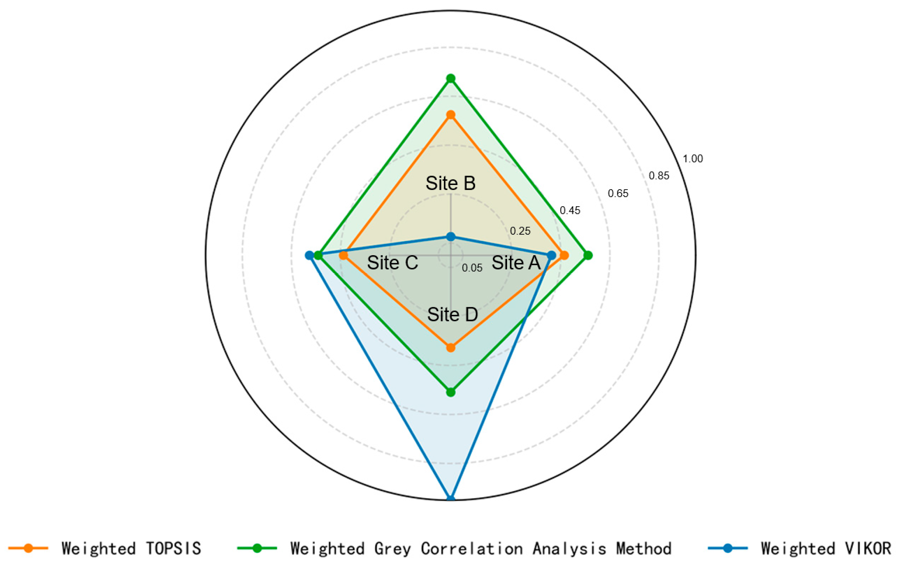
4.4.3. Comparative Analysis
5. Conclusions
Author Contributions
Funding
Data Availability Statement
Conflicts of Interest
References
- Zhu, K.; Sun, G.; Shi, L.; Lin, S.; Yu, X. A nonlinear damage constitutive model applicable to the surrounding rock of compressed air energy storage caverns. J. Energy Storage 2025, 107, 115048. [Google Scholar] [CrossRef]
- Sun, G.H.; Zhu, K.Y.; Ji, W.D.; Yi, Q.; Geng, X.; Yu, X. Basic concepts, design principles, and methods of compressed air energy storage underground caverns. Hazard Control. Tunn. Undergr. Eng. 2024, 6, 14–23. [Google Scholar] [CrossRef]
- Sun, G.; Yi, Q.; Yao, Y.; Shang, H.; Ji, W. Study on the potential instability patterns of tunnel type underground caverns for compressed air energy storage. Chin. J. Rock Mech. Eng. 2024, 43, 41–49. [Google Scholar] [CrossRef]
- Calero, I.; Cañizares, C.A.; Bhattacharya, K. Compressed Air Energy Storage System Modelling for Power System Studies. IEEE Trans. Power Syst. 2019, 34, 3359–3371. [Google Scholar] [CrossRef]
- Kim, H.M.; Rutqvist, J.; Jeong, J.H.; Choi, B.H.; Ryu, D.W.; Song, W.K. Characterizing Excavation Damaged Zone and Stability of Pressurized Lined Rock Caverns for Underground Compressed Air Energy Storage. Rock Mech. Rock Eng. 2013, 46, 1113–1124. [Google Scholar] [CrossRef]
- Yang, C.H.; Wang, T.T. Advance in deep underground energy storage. Chin. J. Rock Mech. Eng. 2022, 41, 1729–1759. [Google Scholar] [CrossRef]
- Peng, W.; Shang, H.L.; Ji, W.D.; Xing, T.G.; Hu, W.; Mou, J.R. The Key Process of Artificial Chamber Location of Compressed Air Energy Storage Power Station. Electr. Power Surv. Des. 2023, 6, 46–49. [Google Scholar] [CrossRef]
- Carranza-Torres, C.; Fosnacht, D.; Hudak, G. Geomechanical analysis of the stability conditions of shallow cavities for Compressed Air Energy Storage (CAES) applications. Geomech. Geophys. Geo-Energy Geo-Resour. 2017, 3, 131–174. [Google Scholar] [CrossRef]
- Jin, W.P.; Peng, Y.C. Underground Gas Storage Cavern Location Method for Compressed Air Energy Storage Engineering in Hard Rock Area. Power Energy 2017, 38, 63–67. [Google Scholar]
- Jiang, Z.M.; Tang, D.; Li, P.; Li, Y. Research on Selection Method for the Types and Sites of Underground Repository for Compressed Air Storage. South. Energy Constr. 2019, 6, 6–16. [Google Scholar] [CrossRef]
- Carneiro, J.F.; Matos, C.R.; van Gessel, S. Opportunities for large-scale energy storage in geological formations in mainland Portugal. Renew. Sustain. Energy Rev. 2019, 99, 201–211. [Google Scholar] [CrossRef]
- Matos, C.R.; Carneiro, J.F.; Pereira da Silva, P.; Henriques, C.O. A GIS-MCDA Approach Addressing Economic-Social-Environmental Concerns for Selecting the Most Suitable Compressed Air Energy Storage Reservoirs. Energies 2021, 14, 6793. [Google Scholar] [CrossRef]
- Zhou, X.S.; Sun, G.B.; Wang, Y.J.; Liu, W.; Huang, K.K. Study on Factors Affecting Site Selection for Artificial Cavern CAES Energy Storage. Electr. Power Surv. Des. 2024, 9, 46–51. [Google Scholar] [CrossRef]
- Wan, F.; Jiang, Z.; Liao, J.; Li, H. Influences of groundwater on air tightness and surrounding rock stability ofCAES underground gas reservoir. Chin. J. Geotech. Eng. 2024, 46, 1899–1908. [Google Scholar]
- Rao, H.; Wang, R. Site Selection and Main Design Principles of Artificial Chamber Gas Storage in Compressed Air Energy Storage Power Station. Electr. Power Surv. Des. 2024, 64–71. [Google Scholar] [CrossRef]
- Xia, C.C.; Xu, Y.J.; Wang, C.L.; Zhao, H.O.; Xue, X.D. Calculation of air leakage rate in lined cavern for compressed air energy storagebased on unsteady seepage process. Rock Soil Mech. 2021, 42, 1765–1773, 1793. [Google Scholar]
- Wang, Z.Y.; Zhuang, X.Y. Numerical Simulation and Analytical Solutionof Hydraulic Fracturing in Sedimentary Rock Tunnels. Mod. Tunn. Technol. 2018, 55, 33–44. [Google Scholar]
- Gao, J.; Men, H.; Guo, F.; Liu, H.; Li, X.; Huang, X. A multi-criteria decision-making framework for compressed air energy storage power site selection based on the probabilistic language term sets and regret theory. J. Energy Storage 2021, 37, 102473. [Google Scholar] [CrossRef]
- Matos, C.R.; Carneiro, J.F.; Silva, P.P. Overview of Large-Scale Underground Energy Storage Technologies for Integration of Renewable Energies and Criteria for Reservoir Identification. J. Energy Storage 2019, 21, 241–258. [Google Scholar] [CrossRef]
- Jiang, Z.M.; Liu, Y.T.; Lu, X.; Yang, X.; Liao, J.H.; Liu, C.Z.; Huang, X.Y.; Zhou, W.F.; Shi, Z.F.; Tian, X.; et al. Review on key scientific and designissues of lined rock caverns for compressed air energy storage. Rock Soil Mech. 2024, 45, 3491–3509. [Google Scholar] [CrossRef]
- Satkin, M.; Noorollahi, Y.; Abbaspour, M.; Yousefi, H. Multi criteria site selection model for wind-compressed air energy storage power plants in Iran. Renew. Sustain. Energy Rev. 2014, 32, 579–590. [Google Scholar] [CrossRef]
- Liu, H.X.; Zheng, Z.X.; Hu, Y.J. Analysis of impact on the stability of high-geostress tunnels with layered rocks dips. J. Transp. Sci. Eng. 2014, 30, 46–50. [Google Scholar] [CrossRef]
- Glamheden, R.; Curtis, P. Excavation of a cavern for high-pressure storage of natural gas. Tunn. Undergr. Space Technol. 2006, 21, 56–67. [Google Scholar] [CrossRef]
- Sharma, S.; Judd, W.R. Underground opening damage from earthquakes. Eng. Geol. 1991, 30, 263–276. [Google Scholar] [CrossRef]
- Goodman, R.E. Methods of Geological Engineering in Discontinuous Rocks; West Group: St. Paul, MN, USA, 1976. [Google Scholar]
- Wang, L.; Zhang, W.; Yang, X.; Cong, X.; Wang, H.; Wang, X.; Long, Y. Research and application progress of abandoned mine compressed air energy storage. Coal Sci. Technol. 2025, 53, 275–292. [Google Scholar]
- Zhao, T.; Liu, S.; Ma, H.; Mei, D.; Wei, Z.; Mei, C. Research status and development trend of compressed air energy storage in abandoned coal mines. Coal Sci. Technol. 2023, 51, 163–176. (In Chinese) [Google Scholar]
- Saaty, R.W. The analytic hierarchy process—What it is and how it is used. Math. Model. 1987, 9, 161–176. [Google Scholar] [CrossRef]
- Opricovic, S.; Tzeng, G.H. Multicriteria Planning of Post-Earthquake Sustainable Reconstruction. Comput. Aided Civ. Infrastruct. Eng. 2002, 17, 211–220. [Google Scholar] [CrossRef]
- Pichler, A.; Schlotter, R. Entropy based risk measures. Eur. J. Oper. Res. 2020, 285, 223–236. [Google Scholar] [CrossRef]
- Ait Omar, M.; Etebaai, I.; Taher, M.; Tawfik, A. Landslide susceptibility mapping in the Bokoya Massif, Northern Morocco: A geospatial and multi-factor analysis using the analytic hierarchy process (AHP). Sci. Afr. 2025, 30, e02980. [Google Scholar] [CrossRef]





| Evaluation Factors | Literature | Illustrate |
|---|---|---|
| C1 | [13] | The type of surface building affects the environmental risk |
| C2 | [13] | Building density affects the difficulty and cost of demolition |
| C3 | [13,21] | Distance to infrastructure such as the power grid is the key accessibility metric |
| C4 | [13] | Access difficulty is mainly controlled by terrain and geomorphologic conditions |
| C5 | [13] | The increase of transportation distance will significantly increase the construction cost |
| C6 | [6,13] | Regional seismic characteristics and multi-field coupling affect engineering safety |
| C7 | [13,22] | The fault will threaten the stability of the chamber under high in-situ stress |
| C8 | [13,14] | Karst development is related to seep and stability |
| C9 | [13,14] | Groundwater system significantly affects the excavation conditions and sealing performance |
| C10 | [10,23] | The lithology type determines the suitability of CAES chamber |
| C11 | [13,21] | Topography affects the cost of line layout and construction |
| C12 | [6,22,23] | The overall performance of the surrounding rock category reaction rock mass under high stress conditions |
| C13 | [6,10,22] | Rock integrity is very important for stress stability and sealing |
| Criteria | Site A | Site B | Site C | Site D |
|---|---|---|---|---|
| Topography | Low mountain and hilly terrain with surface elevations ranging from 70 to 350 m, a relative elevation difference of 280 m, and high vegetation coverage. | Hilly terrain with ground elevations ranging from 100 to 172 m, featuring relative elevation differences of approximately 30 to 72 m and high vegetation coverage. | Low mountain eroded hills feature natural slopes with gradients typically ranging from 5 to 10 degrees, and the mountain slopes are densely vegetated. | Low mountain eroded hills feature natural slopes with gradients typically ranging from 5 to 8 degrees, and the mountain slopes are densely vegetated. |
| Lithology | Yanshanian Stage II Changshan Granite ), overlain by residual slope deposits of silty clay. | Yanshanian Stage II Changhua Granite ) is overlain by residual slope deposits of silty clay. It crosses the boundary between intrusive rocks of different stages; the contact zone surrounding the rock conditions is slightly poorer. | Lower Permian Maokou Formation ) strata, overlain by gravelly silty clay. | Lower Permian Maokou Formation ) limestone. |
| Regional geomorphic geological | Tectonic Unit IV-4-9-4: Northeast Hunan Anticline Belt; Belongs to the Xin-Huangxia tectonic system, with regional faults trending north-northeast. | Tectonic Unit IV-4-9-4: Northeast Hunan Anticline Belt; Belongs to the Xin-Huangxia tectonic system, with regional faults trending north-northeast. | Folds from the Ordovician to the Jurassic. The fold axes generally trend northwest to nearly east–west. | Folds from the Ordovician to the Jurassic. The fold axes generally trend northwest to nearly east–west. |
| Regional Seismic Characteristics | Seismic design intensity is 6 degrees. | Seismic design intensity is 6 degrees. | Seismic design intensity is 6 degrees. | Seismic design intensity is 6 degrees. |
| Hydrogeological Conditions | Groundwater types are primarily bedrock fracture water and loose layer pore water, with relatively small water volumes. | The primary groundwater type is bedrock fissure water, with relatively low water volume. | Karst water and slope seepage during the rainy season, with relatively small water volumes. | Karst water and slope seepage during the rainy season, with low water volume. |
| Engineering geological | Surface features within the site include landslides and rockfalls, which influence the selection of cave entry points but do not affect underground chambers. No other adverse geological phenomena are present. | No adverse geological phenomena were detected within the site. | The primary adverse geological phenomena or hazards within the site include karst formations, landslides, rockfalls, and fractured zones. | No adverse geological phenomena or hazards such as landslides, ground subsidence, debris flows, or ground sinking were identified, except for slopes, high embankments formed by backfilling and excavation, and karst features. |
| Site stability and adaptability | No factors affecting the safety of underground caverns were identified at the site, which is deemed stable and suitable for the construction of this project. | No factors affecting the safety of underground caverns were identified at the site, which is deemed stable and suitable for the construction of this project. | No factors affecting the safety of underground caverns were identified at the site, which is deemed stable and suitable for the construction of this project. | No factors affecting the safety of underground caverns were identified at the site, which is deemed stable and suitable for the construction of this project. |
| Rock mass type | Weakly weathered granite with rock integrity ranging from relatively intact to intact. Predominantly, the surrounding rock is Class II to III, with localized areas potentially more fragmented. Surrounding rock classification: Class IV. | Weakly weathered granite with rock integrity ranging from relatively intact to intact. Predominantly, the surrounding rock is Class II to III, with localized areas potentially more fractured. Surrounding rock classification: Class IV. | The surrounding rock consists of moderately weathered limestone, classified as hard rock with a relatively intact rock mass, predominantly falling under Class II to III rock mass. Joints and fractures are moderately developed, resulting in a Class IV rock mass rating. | The surrounding rock consists of moderately weathered limestone, classified as hard rock with relatively intact mass and layered structure, predominantly falling under Class II to III rock mass. Joints and fractures are well-developed, with good cementation on fracture surfaces, resulting in a Class IV rock mass rating. |
| Ground Environment | Infrastructure is available in some areas. | Scattered infrastructure. | Infrastructure is available in some areas. | No existing structures. |
| Transportation | Construction access roads may need to be built near rural roads. | County roads and rural roads directly connect to the site. | Paved rural roads connect the site, offering generally convenient transportation access. | P paved rural roads connect the site, offering relatively convenient transportation access. |
| Construction Conditions | The adit access is near the surface yard area, with the entrance positioned within the perimeter. The adit extends 680 m in length. | The adit access configuration features an adit portal located near the surface yard area, with a horizontal projection length of 550 m. | The adit access configuration features an adit portal located near the surface yard area, with a horizontal projection length of 745 m. | The adit access is near the surface yard area, with the entrance positioned within the perimeter. The adit extends 690 m in length. |
| Goal Layer | Criterion Layer | Index Layer | Site A | Site B | Site C | Site D |
|---|---|---|---|---|---|---|
| Evaluation of the CAES Site | Ground environment B1 | Types of surface buildings and structures C1, values range from 0 to 100 | 90 | 90 | 90 | 95 |
| Density of surface buildings and structures C2/%, values range from 0 to 100 | 10 | 11 | 10 | 3 | ||
| Construction convenience B2 | Access distance C3/km, values range from 0 to 10 | 8 | 9 | 9 | 5 | |
| Access difficulty C4, values range from 0 to 0.4 | 0.10 | 0.14 | 0.13 | 0.12 | ||
| Haul distance C5/km, values range from 0 to 50 | 5.1 | 4 | 5 | 4 | ||
| Regional geological characteristics B3 | Regional seismic characteristics C6/Intensity, values range from 1 to 8 | 6 | 6 | 6 | 6 | |
| Characteristics of fault development C7/km, minimum value is 25 km | 270 | 290 | 170 | 200 | ||
| Karst development C8/Permeability of drilled rock cavities, values range from 0 to 1 | 0.14 | 0.15 | 0.15 | 0.15 | ||
| Distribution of groundwater system C9, values range from 0 to 100 | 90 | 91 | 90 | 89 | ||
| Basic geological characteristics B4 | Formation lithology C10, values range from 40 to 100 | 83 | 84 | 84 | 84 | |
| Topography C11/°, values range from 0 to 30° | 7 | 6.5 | 6 | 7 | ||
| Surrounding rock classification C12, values range from 1 to 4 | 2 | 2 | 2 | 2 | ||
| Rock mass integrity degree C13/RQD, values range from 50 to 100% | 86 | 88.5 | 86 | 85 |
| Index Layer | |||
|---|---|---|---|
| Types of surface buildings and structures C1 | 0.0253 | 0.1485 | 0.0827 |
| Density of surface buildings and structures C2 | 0.0316 | 0.0801 | 0.0542 |
| Access distance C3 | 0.0521 | 0.0949 | 0.0720 |
| Access difficulty C4 | 0.0375 | 0.0462 | 0.0415 |
| Haul distance C5 | 0.0323 | 0.0584 | 0.0444 |
| Regional seismic characteristics C6 | 0.0553 | 0.1485 | 0.0987 |
| Characteristics of fault development C7 | 0.0684 | 0.0443 | 0.0572 |
| Karst development C8 | 0.0624 | 0.1485 | 0.1025 |
| Distribution of groundwater system C9 | 0.0772 | 0.0372 | 0.0586 |
| Formation lithology C10 | 0.1029 | 0.0309 | 0.0694 |
| Topography C11 | 0.0839 | 0.0804 | 0.0823 |
| Surrounding rock classification C12 | 0.2042 | 0.0309 | 0.1235 |
| Rock mass integrity degree C13 | 0.1669 | 0.0513 | 0.1131 |
| Site | Sorting | Sorting | Sorting | |||
|---|---|---|---|---|---|---|
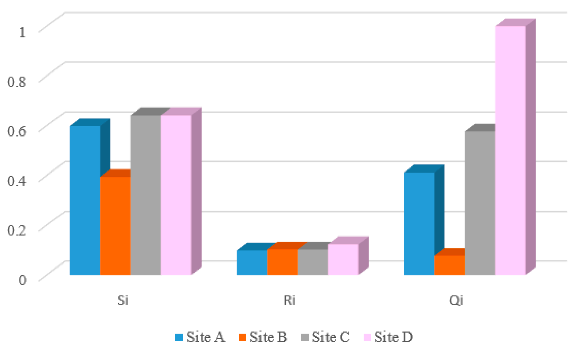
| A | 0.5984 | 0.0987 | 0.4118 | 2 | 2 | 2 |
| B | 0.3940 | 0.1025 | 0.0765 | 1 | 1 | 1 |
| C | 0.6421 | 0.1025 | 0.5762 | 3 | 1 | 3 |
| D | 0.6422 | 0.1235 | 1 | 4 | 3 | 4 |
| Site | ||||||||||
|---|---|---|---|---|---|---|---|---|---|---|
| Sorting | Sorting | Sorting | Sorting | Sorting | ||||||
| A | 0.0824 | 1 | 0.2471 | 2 | 0.4118 | 2 | 0.5765 | 2 | 0.7412 | 2 |
| B | 0.1377 | 2 | 0.1071 | 1 | 0.0765 | 1 | 0.0459 | 1 | 0.0153 | 1 |
| C | 0.2376 | 3 | 0.4069 | 3 | 0.5762 | 3 | 0.7455 | 3 | 0.9147 | 3 |
| D | 1 | 4 | 1 | 4 | 0.8420 | 4 | 1 | 4 | 1 | 4 |
| Site | Sorting | |||
|---|---|---|---|---|
| A | 0.2068 | 0.1790 | 0.4639 | 2 |
| B | 0.1699 | 0.2301 | 0.5752 | 1 |
| C | 0.2186 | 0.1700 | 0.4375 | 3 |
| D | 0.2465 | 0.1496 | 0.3777 | 4 |
Disclaimer/Publisher’s Note: The statements, opinions and data contained in all publications are solely those of the individual author(s) and contributor(s) and not of MDPI and/or the editor(s). MDPI and/or the editor(s) disclaim responsibility for any injury to people or property resulting from any ideas, methods, instructions or products referred to in the content. |
© 2025 by the authors. Licensee MDPI, Basel, Switzerland. This article is an open access article distributed under the terms and conditions of the Creative Commons Attribution (CC BY) license (https://creativecommons.org/licenses/by/4.0/).
Share and Cite
Chen, B.; Zang, Z.; Xiao, Y.; Ding, H.; Lin, S.; Dong, M. Research on the AHP–EWM–VIKOR Model and Comprehensive Evaluation Method for Selecting Sites for Artificial Caverns in CAES. Processes 2025, 13, 4048. https://doi.org/10.3390/pr13124048
Chen B, Zang Z, Xiao Y, Ding H, Lin S, Dong M. Research on the AHP–EWM–VIKOR Model and Comprehensive Evaluation Method for Selecting Sites for Artificial Caverns in CAES. Processes. 2025; 13(12):4048. https://doi.org/10.3390/pr13124048
Chicago/Turabian StyleChen, Bin, Zhonghai Zang, Yucheng Xiao, Hongyuan Ding, Shan Lin, and Miao Dong. 2025. "Research on the AHP–EWM–VIKOR Model and Comprehensive Evaluation Method for Selecting Sites for Artificial Caverns in CAES" Processes 13, no. 12: 4048. https://doi.org/10.3390/pr13124048
APA StyleChen, B., Zang, Z., Xiao, Y., Ding, H., Lin, S., & Dong, M. (2025). Research on the AHP–EWM–VIKOR Model and Comprehensive Evaluation Method for Selecting Sites for Artificial Caverns in CAES. Processes, 13(12), 4048. https://doi.org/10.3390/pr13124048