Abstract
Currently, the load on railway tracks is increasing due to the increase in freight traffic. Accordingly, more and more serious requirements are being imposed on the reliability of the roadbed, which means that studies of methods for monitoring the integrity of the railway roadbed are relevant. The article provides a mathematical substantiation of the possibility of using seismoelectric and phasemetric methods of geoelectric control of the roadbed of railway tracks in order to identify defects and deformations at an early stage of their occurrence. The methods of laboratory modeling of the natural–technical system “railway track” are considered in order to assess the prospects of using the presented methods. The results of laboratory studies are presented, which have shown their high efficiency in registering a weak useful electrical signal caused by seismoacoustic effects against the background of high-level external industrial and natural interference. In the course of laboratory modeling, it was found that on the amplitude spectra of the output electrical signals of the investigated geological medium in the presence of an elastic harmonic action with a frequency of 70 Hz, the frequency of a harmonic electrical signal with a frequency of 40 Hz is observed. In laboratory modeling, phase images were obtained for the receiving line when simulating the process of sinking the soil base of the railway bed, confirming the presence of a transient process that causes a shift in the initial phase of the signal Δφ = 40° by ~45° (Δφ’ = 85°), which allows detection of the initial stage of failure formation.
1. Introduction
The railway is one of the most important cargo transportation systems in the world due to the rapid development of this class of heavy transport, as well as its efficiency in comparison with other transport systems. At the same time, the increase in railway maintenance costs is directly related to the increase in the volume of cargo transportation [1]. Accordingly, in this regard, the requirements for the reliability and safety of the functioning of railway tracks and railway infrastructure in general are significantly increasing, the provision of which through technical monitoring is extremely important and relevant, and, as a result, is the focus of plentiful scientific and applied research [2,3,4].
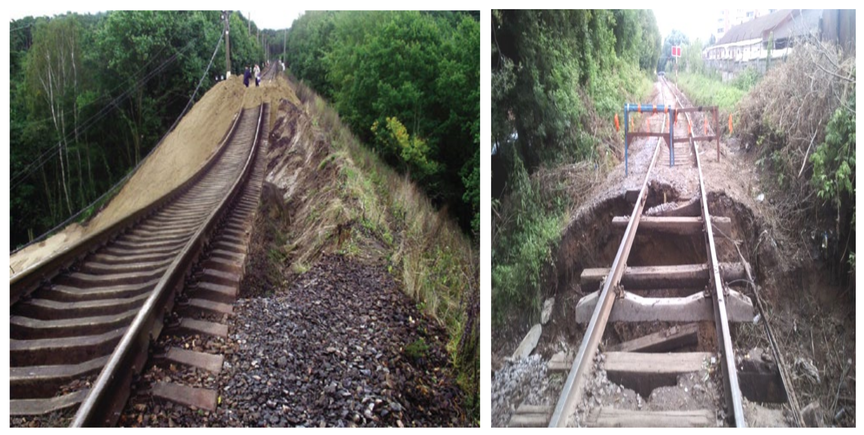
This task is complicated by the fact that special requirements for the construction and operation of railways are imposed in areas of activation of geodynamic processes, where there is a significant risk of landslides and the formation of karst craters, which are associated with intensive cyclic impact on the ground base of passing trains [4]. According to the Richter scale, the efficiency of such transport vibration is equivalent to an earthquake of 3–6 points [5]. Moreover, it is known that landslide deformations affect natural and artificial geological environments and can have a varied nature of development, and the activation of karst processes in the area of railway tracks can lead to a gradual destruction of the subgrade (Figure 1) [4]. In addition, the reasons for the deformation of the roadbed may be the discrepancy between the power of the upper structure of the track to the intensive dynamic loads of railway transport, as well as the unfavorable effects of climatic and engineering–geological factors.

Figure 1.
Sudden destruction of the railway roadbed as a result of natural factors.
It should be noted that the main undesirable activation of near-surface geodynamics arises not at the stage of engineering surveys and construction works, but in the process of direct operation of railway tracks and in most cases is of a sudden, spontaneous nature.
As a result, the indicated defects and deformations of the subgrade lead to the transition of the “railway track-subsoil” system into an unstable state, the moment of occurrence of which is not predicted by modern control systems. Geodeformational changes in the soil lead to a significant deterioration of the railway track, which, in turn, leads to the need to reduce the negative impact of geodeformational changes on the railway track, since the quality and condition of the track directly affects the safety of the movement of trains [3] and the efficiency of its interaction with infrastructure [4]. To detect the early stage of the development of deformation processes of the roadbed of a railway track and predict the dynamics of their development in time, it is important to have current and model information about its state and possible undesirable changes.
Thus, the purpose of the research is to develop methods for monitoring geodynamic changes in the railway roadbed, to detect the appearance of various kinds of anomalies and inhomogeneities, indicating the development of destructive processes in the soil, to create and test a laboratory model of the natural–technical system “railway track” in order to assess the prospects of using the presented methods.
2. Literature Review
The most reliable method of monitoring the condition of the railway roadbed at the moment is surveying and geodetic observations on the reference points of profile lines [6]. However, due to the large length of railway tracks, the use of this method is very difficult, and the control of the roadbed and the adjacent territory by engineering–geological methods are inappropriate. In this case, it is relevant to attract geophysical methods that are widely used in exploration and engineering geology.
Currently, to obtain information about the structure of the upper layers of various geological environments, ground-penetrating radar sounding [7], vibroseismic methods [8,9,10,11], electrometric [9,10,11,12] and some other methods are traditionally used. But in some cases, such as when karst cavities have a developed structure, analysis by groups of these methods is very difficult [13,14].
According to the results of numerous studies, it has been established that when organizing automated control of geodynamic objects, the most promising is the use of geoelectric methods of media sounding. They provide effective observations of geological objects, as well as assessment of the state and forecast of their development, which is determined by their high technology [8,10,11,12,15].
However, as practice shows, the application in geodynamic monitoring of any single method chosen from the ones considered above is not effective enough. As a result, it is necessary to choose the most preferred research method for each specific task [16]. For instance, some research has been done on dynamic prediction models for tunnels [17,18], railway tracks [19], oil sludge straits [20], as well as various underground structures [21] and geotechnical applications in general [22]. But the usual problem of such methods is the ambiguity of the assessment of geophysical data.
The joint use of geoelectric and seismic methods, that is, the use of the seismoelectric control method [23,24,25,26,27,28,29], allows increasing the efficiency of geological media studies by reducing the ambiguity of the assessment of geophysical data.
In the course of laboratory modeling, it is planned to study the amplitude spectra of the output electrical signals of the monitored geological environment in the presence of elastic harmonic action, which will allow using this effect to obtain more detailed information about the structure of the soil during sounding by electric fields. In this case, the registration of the phase component of the signal of the receiving lines will presumably increase the noise immunity of measurements. The presence of a transient process causing a shift in the initial phase of the signal of the receiving lines of the installation will indicate the initial stage of the dip formation.
In this regard, the purpose of the work is to substantiate and study an integrated approach to solving problems of monitoring the subsurface of railway tracks and the adjacent territory to identify the initial stage of defects and deformations in it based on the use of the seismoelectric method.
3. Mathematical Description of the Seismoelectric Method of Monitoring the Ground Bed of Railway Tracks
The seismoelectric control method is based on secondary seismic effects. It consists of the interpretation of signals of an electrical or seismic nature, recorded by the geodynamic monitoring system, which are received when vibrations of these types are simultaneously excited in the studied medium. The method is based on the assumption that the real geological environment is a porous polyphase complex structure in an energetically unstable state. The combined effect of physical fields of various nature (electromagnetic and elastic) on the studied geological environment can lead to a change in its physical properties. The seismoelectric effect of the first kind is the phenomenon of changing the electrical resistance of the geological medium under the influence of elastic vibrations; the second kind is the phenomenon of excitation of an electromagnetic field that occurs under similar conditions. These effects determine, first of all, the nature of the impact on the results of electrical measurements of vibrational seismic–acoustic noise caused by the movement of railway transport. In addition, the nature and degree of their manifestation depend on a number of additional factors, which include the mineral composition of the solid skeleton of the geological environment and its structure, porosity, permeability and structure of pore channels, composition and volume of mineral cement, composition and mineralization of the liquid saturating the pores, etc.
The most important advantage of the seismoelectric method in comparison with traditional methods of applied geophysics is the unambiguity of solving inverse problems. In addition, the role of this method increases significantly with increasing depth and resolution of studies.
In the literature [8,9] it has been demonstrated that with the practical use of the seismoelectric method, the most informative is the study of the recorded electrical signals. This is due to two factors. Firstly, structural changes in various media, first of all, affect their average conductivity, which is characterized by a seismoelectric effect of the first kind. Secondly, there is always a double electric layer with a mobile diffuse part at the boundaries of solid media and pore fluid. Elastic action on such a medium often leads to a relative movement of the porous fluid, which, in turn, generates an external electric current that creates an electromagnetic field—a seismoelectric effect of the second type. In addition, various rock-forming minerals have different types of conductivity: ionic, electron, hole. The contact of such minerals with different types of conductivity can also lead to the emergence of new electric fields. Thus, it is proposed to consider the electrical component as the observed component of the method under study.
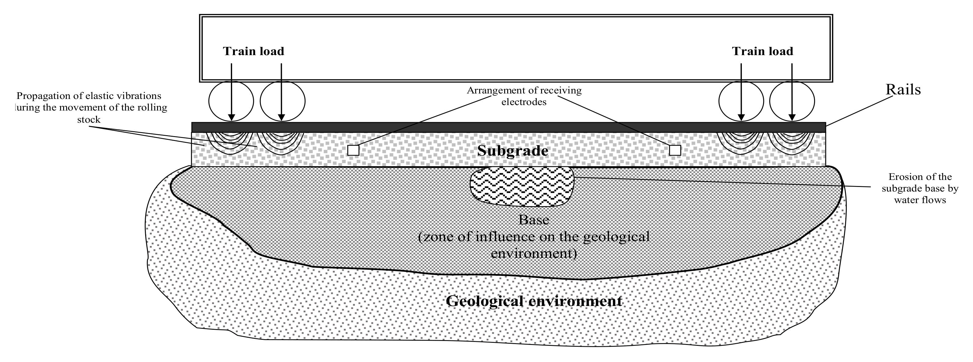
The principal possibility of monitoring the roadbed with the use of natural or artificially created geophysical fields is determined by the fact that the selected objects (inhomogeneities) differ in properties from the host medium and as a result create anomalous geophysical fields. In our case, the source of elastic vibrations can be railway trains passing through the studied area (Figure 2). These effects have high energy, and the characteristics of this effect are a priori known [3,4,7,12,20,29]. Geodynamic variations of these fields are a consequence of the action of both natural factors and man-made impacts on the environment, and this makes it possible to distinguish them based on the processing of geodynamic data. At the same time, the seismic impact will highlight the characteristic features in the analyzed signal, adding auxiliary information about the structure of the medium to the controlled parameters, manifested at the combination frequencies of the impact.

Figure 2.
The principle of application of seismoelectric control of the railway trackbed.
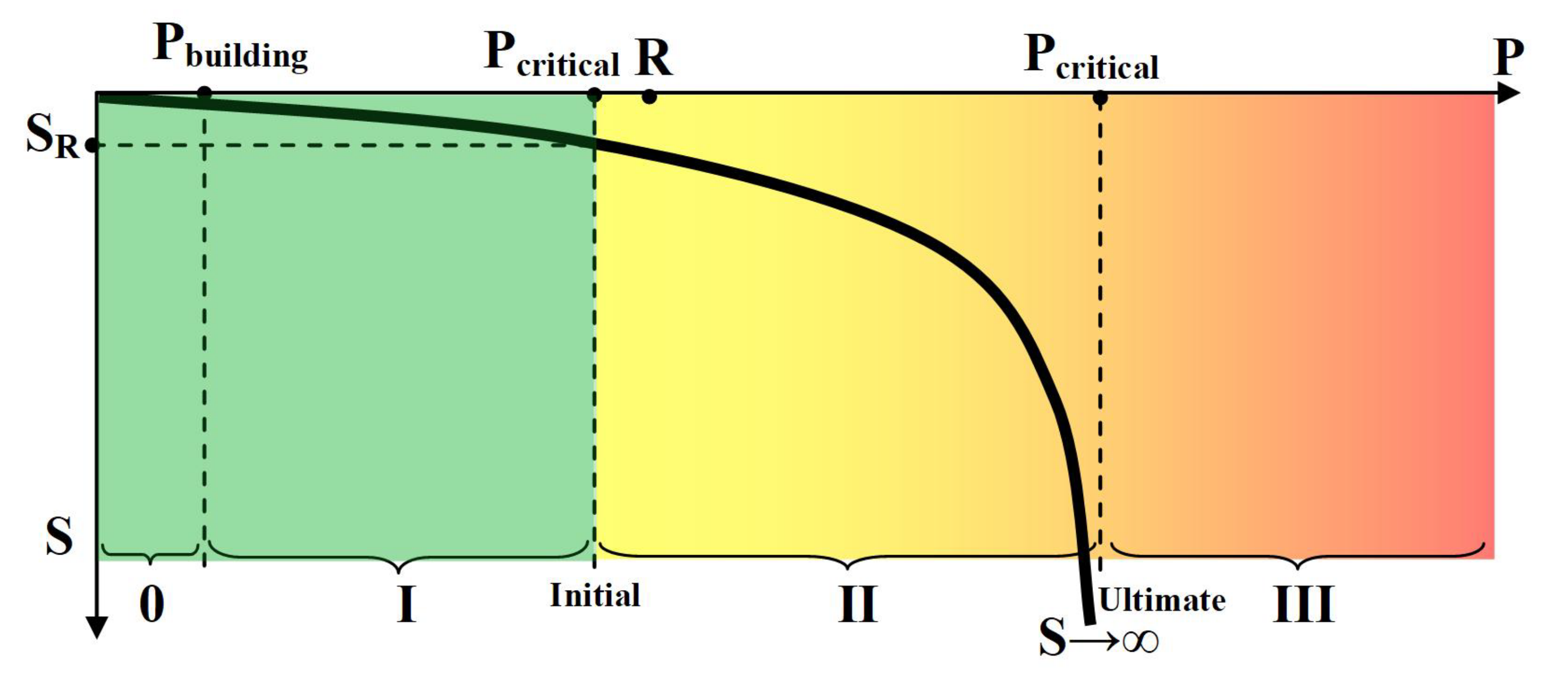
Since the ground base of a railway track can be represented as a base formed by solid particles and a liquid pore filler, the type of deformation processes developing in it will be determined primarily by the physical causes and properties of the specified components and described by the dependence of the stress–strain state of the soil depending on the applied load containing four phases (Figure 3).
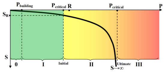
Figure 3.
Model of the stress–strain process of the ground base of the railway track.
According to this model, the elastic deformation phase (0) is up to 10% of the permissible load on the soil and is limited by the value of structural strength, assuming that no structural changes occur in the soil under these loads. The compaction phase (I) is determined by the linear relationship between the applied load and the total deformation of the soil base. The shift phase (II) characterizes the processes of destruction determined by significant shear deformations due to exceeding the limit. The extrusion phase (III) characterizes irreversible deformations, in which the soil is squeezed out from under the railway track.
A similar character, in accordance with the seismoelectric effect of the first kind, is the dependence of the electrical resistance of the ground base on the applied mechanical load (due to the movement of railway transport along the track), which can be considered its amplitude characteristics, and the amplitude and phase spectra of the response to this seismic action are indicators of the development of deformation processes.
The advantage of this approach is that the railway transport generates an intense and long-lasting seismic acoustic signal, the parameters of which change slightly over time relative to the passing train, which eliminates the need to use additional sources of seismic signals. Moreover, it is known that the level of noise generated by a rolling stock consists of the following components: drive noise, aerodynamic noise and wheel rolling noise [30,31]. The first two types of noise can be considered stationary background noise, and the third one arises due to the contact of wheels with the rail and is associated with the high rolling pressure of steel on steel, characteristic of the “wheel-rail” system [32]. In the frequency domain, these noises are sources of low-frequency vibrations, the propagation speed of which coincides with the speed of the train movement. As a result, the spectrum of the resulting seismic signal can be divided into four frequency ranges from 3 to 80 Hz.
In accordance with the above, when implementing the seismoelectric method, as an informative parameter, it is necessary to use the complex transfer function of the investigated section of the geological environment [33]:
where are complex resistances of grounding; E(jω), I(jω) are complex parameters of the electric field; ω is frequency of the probing signal; are complex resistances of the i-th elements of the studied section of the geological environment under seismoacoustic influence Δu.
The expression of the transfer function of the studied geological medium (1) is a geoelectric model of complex resistances connected in series. Such a representation allows us to use the pattern of an N-layer imperfect dielectric. This model contains N elements, and each element has thickness of d and the following electrical parameters of the i-th element—dielectric permissivity and electrical resistivity . The transfer function of the area under investigation can be expressed as the form of RC circuits connected in series, while each circuit has the following parameters [34]:
where the effective area S(jω) is determined by the skin effect.
If we omit the the grounding parameters, then we might simply represent the transfer function of the geoelectric section from the dielectric parameters (2):
where .
At the same time, when an elastic seismic wave propagates in the geological environment, each of its i-th element undergoes a mechanical influence described by the deformation tensor .
The transfer function (3) can be written in exponential form as
where p is the Laplace operator, is the module of the transfer function, Re and Im are real, and the imaginary part of the complex function, accordingly, is the argument of the transfer function.
The module and phase of this transfer function can be calculated based on the input–output model from the ratio
where X(p,Δu) is the probing electrical signal in operator form, Y(p, Δu) is the recorded electrical signal in operator form.
In this case, the ground base of the railway track can be represented as a dynamic link—Figure 4.
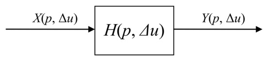
Figure 4.
Representation of the ground base of the railway track in the form of a dynamic link.
By converting (5) taking into account (4), we obtain
where .
It follows from the last expression that the control of the ground base of the railway track can be carried out by tracking both the module and the argument (phase) of the recorded geoelectric signals (since the parameters of the probing signals are constant and are a priori known).
4. Methodology of Experimental Research on the Model of the Natural–Technical System “Railway Track”
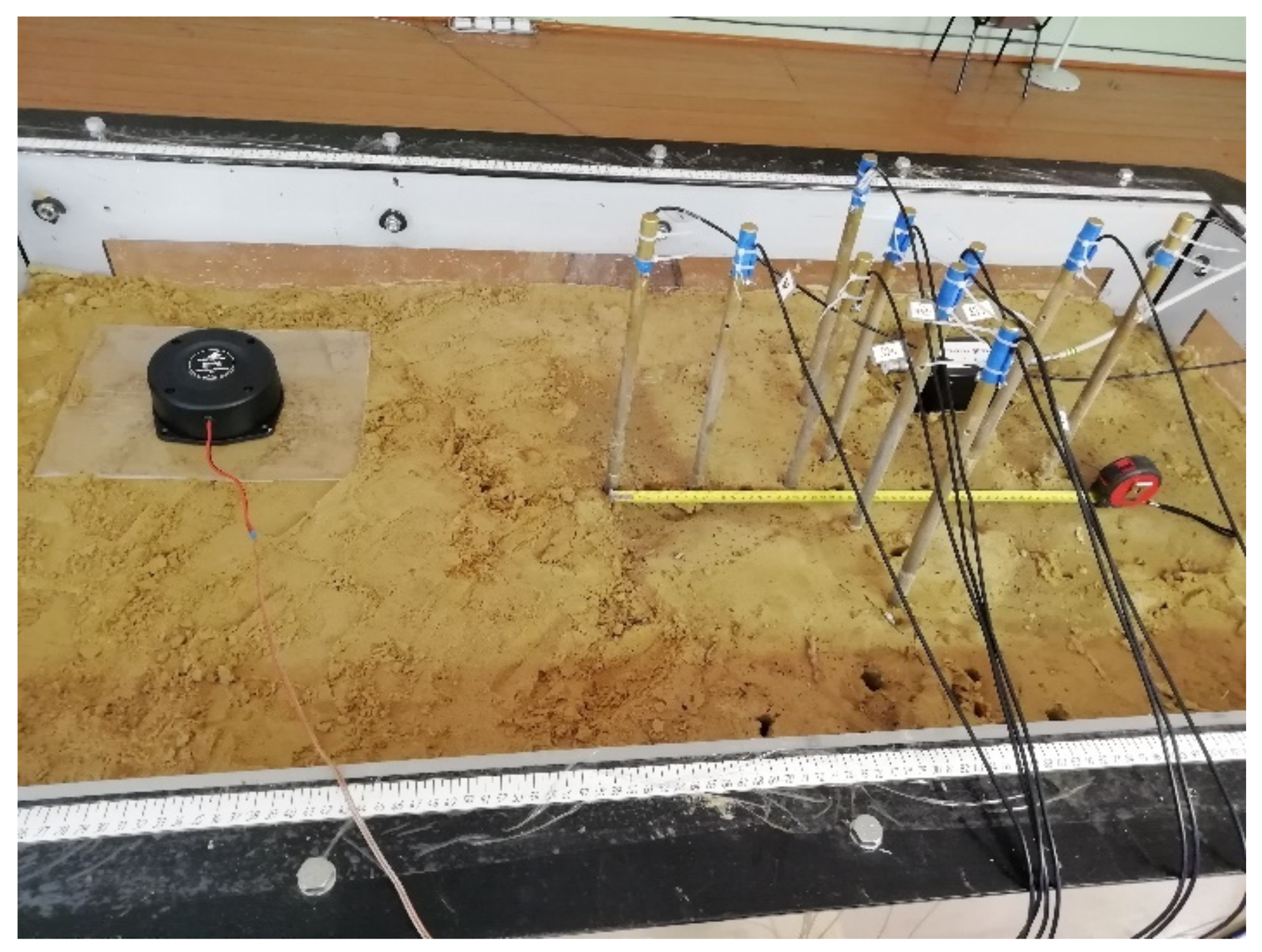
To assess the prospects of the seismoelectric method in the railway roadbed monitoring, we have done laboratory modeling of the railway track. The laboratory installation is shown in the Figure 5. It allows us to simulate the seismic influence of a train passing by, as well as the natural processes (changes in soil moisture, suffosion, karst, landslide processes, sinkholes).

Figure 5.
Geodynamic object model.
The installation consists of the following parts:
- -
- a small-scale model of a geodynamic object—a tank with sandy soil, in which it is possible to simulate its full or partial mudflow by means of extracting certain sections of the bottom of the tank; the seismic effect is a vibration source (black box on the left);
- -
- current signal sources, signal registration—metal rods used to generate and register an electric field;
- -
- geodynamic data processing system, which is an analog-to-digital converter, seismic station, personal computer with developed specialized software.
Primary to the current study, the noise of a railway train was generally registered by a microphone located in the ground base of the railway track. With direct modeling, the seismic impact was simulated by reproducing the recorded noise using a seismic signal source—a vibration loudspeaker.
During the study, we were modeling the soil collapse while registering changes in the characteristics of seismic and electrical signals. Thus, we obtained information about the primary stage of the soil collapse. The proposed approach allows detection of the primary phase of destruction of the railway roadbed, as well as prevention of the man-made catastrophes in the natural–technical system “railway track”.
5. Results and Discussion
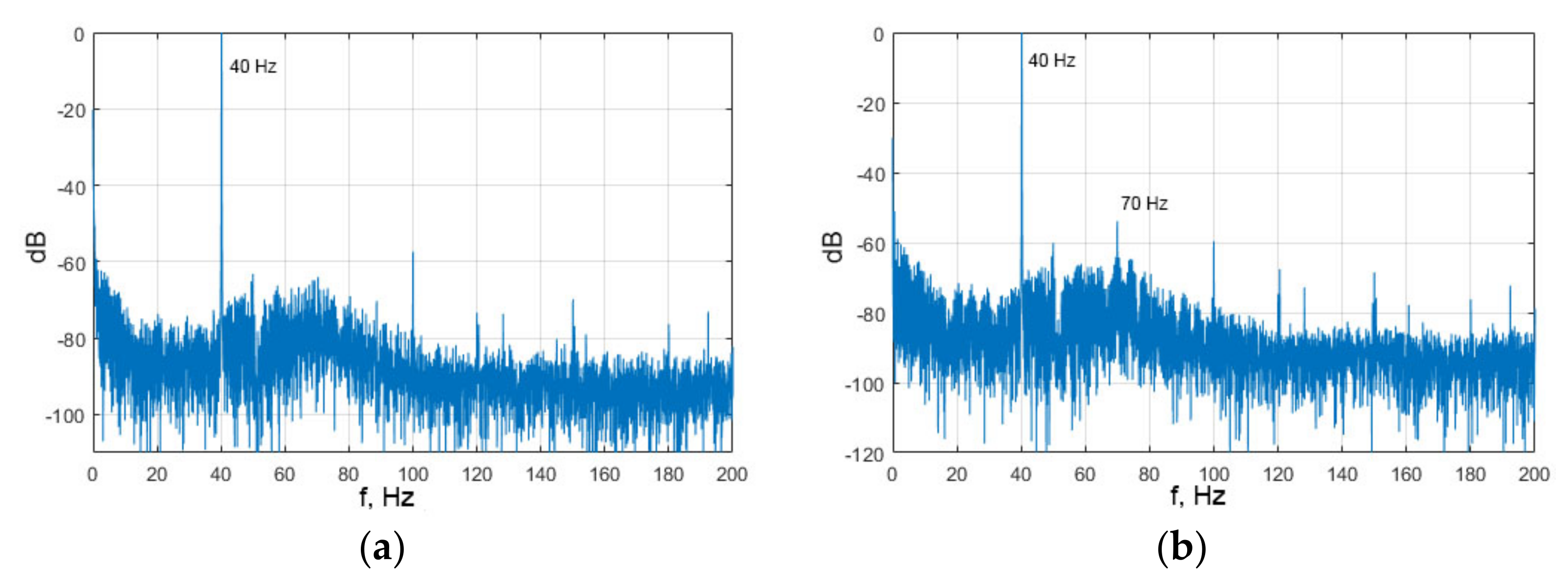
Figure 6 represents amplitude spectra of the output electrical signals of the investigated geological environment in the absence (a) and presence (b) of elastic action (if applied, an elastic harmonic impact had a frequency of 70 Hz). At the same time, the harmonic electrical signal had a frequency of 40 Hz.
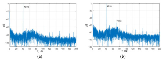
Figure 6.
Amplitude spectra of the output electrical signals of the investigated geological environment in the absence (a) and presence (b) of elastic action.
It can be seen from the obtained spectrograms that the presence of an elastic seismoacoustic impact source in the simulated ground base of the railway track leads to the formation of a spectral component with a frequency of seismoacoustic impact in the spectrum of the recorded electrical signal (seismoelectric effect of the second type). This indicates that in this case, the geological environment has a normal specific resistivity (seismoelectric effect of the first type), and there is no deformation of the soil compaction. Depending on the parameters of external elastic influences applied to the investigated area, the electrical parameters of the medium change their characteristics accordingly. This makes it possible, during further processing of the received electrical signal, to determine the presence of heterogeneity in the medium, its depth and deformation state. In this case, there is no need to place the sensors along the entire monitored area.
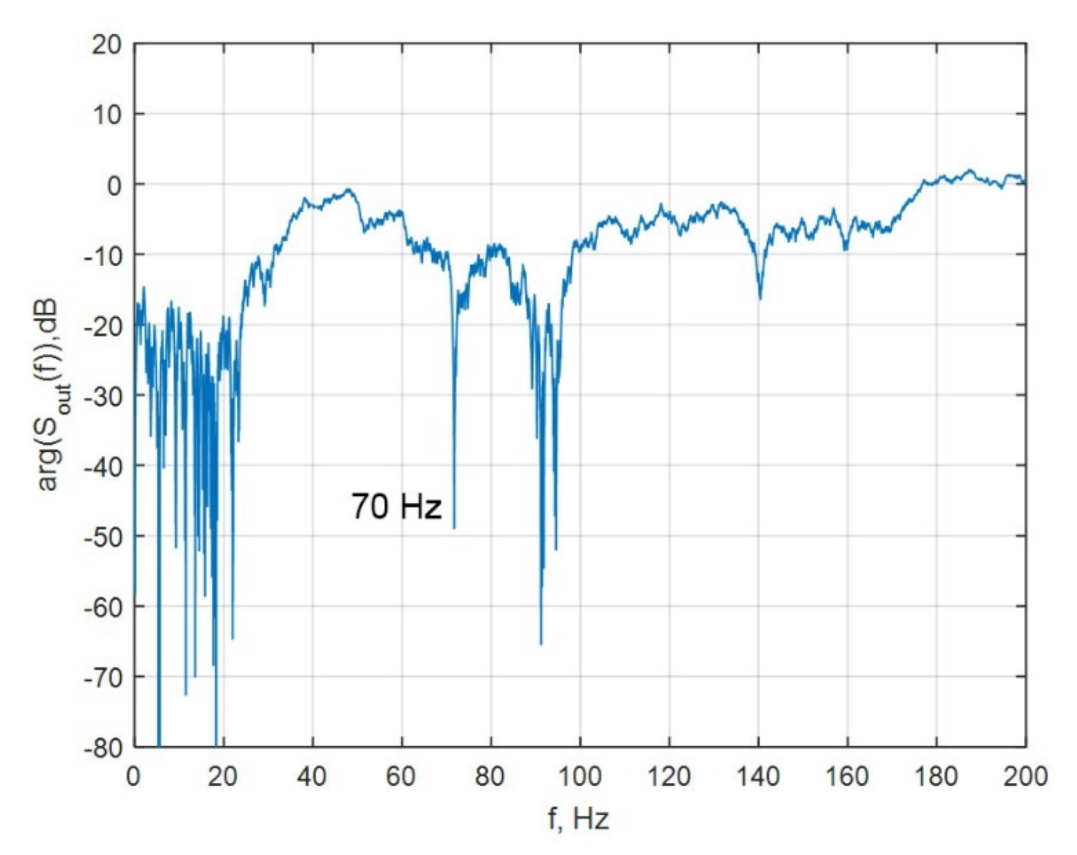
Further studies have shown that the analysis of changes in the phase characteristics of the transfer function (6) has a number of significant advantages over the amplitude method; in particular, it is characterized by increased sensitivity and noise immunity [30] and also detects and localizes geodynamic processes in geological environments [30,31,32]. In Figure 7 as an example, the phase spectrum of the output electrical signals of the geological medium under study was measured while applying the 70 Hz elastic action, because at such frequency a phase shift of seismic acoustic action is clearly traced.
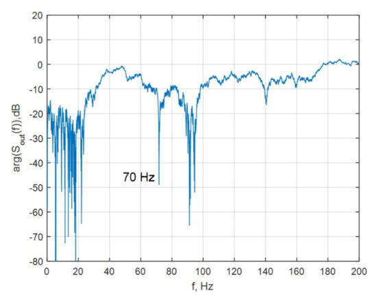
Figure 7.
Phase spectrum of the output electrical signals of the studied geological medium in the presence of elastic action.
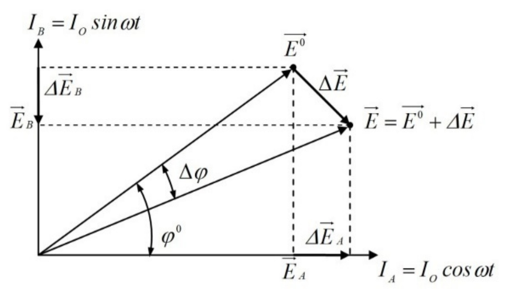
Studies [25,26,27] explain the modified phase-measuring method of geoelectric control, namely the use of several current signal sources placed closely to the test control object and an array of vector sensors for measuring the electric field. At the same time, the registration of phase characteristics at a fixed position of the sources and the measuring basis with the possibility of controlling the parameters of the probing signals is based on the fact that the primary and secondary electric fields are vector values.
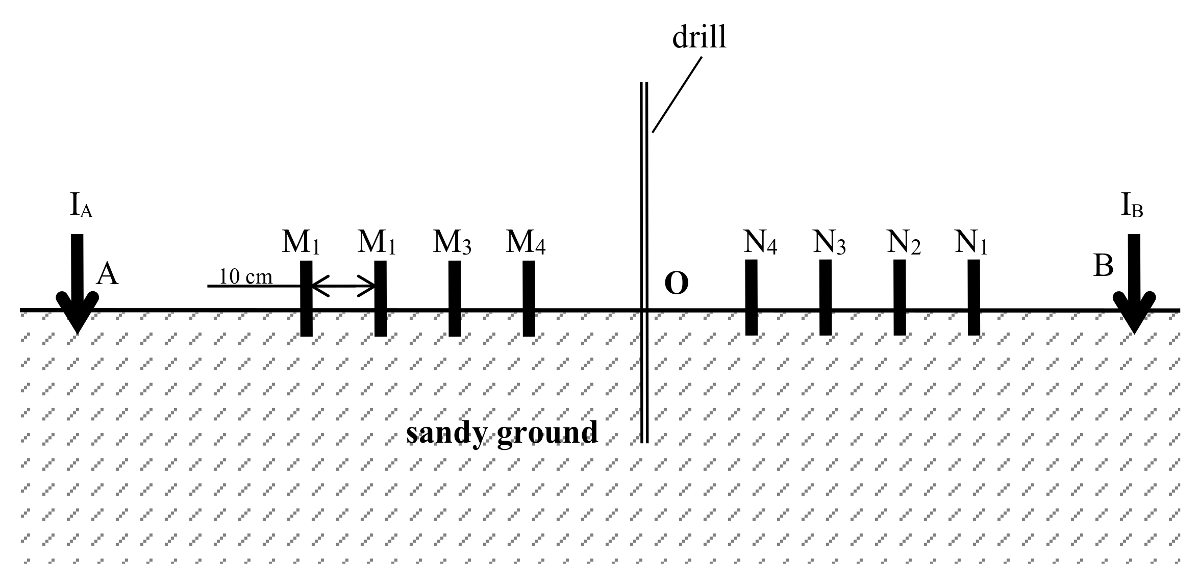
Figure 8 shows a diagram of the laboratory experiment to control the process of occurrence and subsequent growth of a cavity in the ground foundation of a railway track by the phasometric method. The research was carried out on a physical model of a railway track using a specially developed measuring phasometric system. In this case, the current sources designated as A and B (Figure 8) form quadrature harmonic signals with a phase shift of 90 degrees. Sources A and B generate an electric field signal at point O, described as follows:
where is the electrical signal recorded before the formation of deformation processes in the ground; is an abnormal component of the electric field caused by the presence of deformation processes in the ground.

Figure 8.
Diagram of the laboratory experiment.
When using multipolar geodynamic control systems at registration points (M1–M4, N1–N4), we have to deal with an elliptically polarized geoelectric field. Moreover, in this case, vector sensors of electric field measurement with the same indices form pairs; the signals from each pair are sent to the measuring system for processing. In this case, data processing of recorded geoelectric signals presupposes the formation of their difference signal (for filtering in-phase interference), its amplification, phase detection (in relation to the reference signal) and low-pass filtering. The principle of registration for the phase of the geoelectric field at an arbitrary receiving point is illustrated in Figure 9.
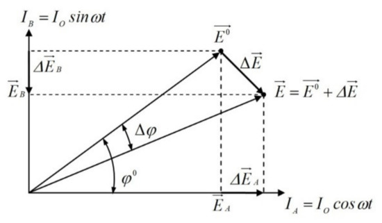
Figure 9.
The registration principle for the phase of the geoelectric field at an arbitrary receiving point.
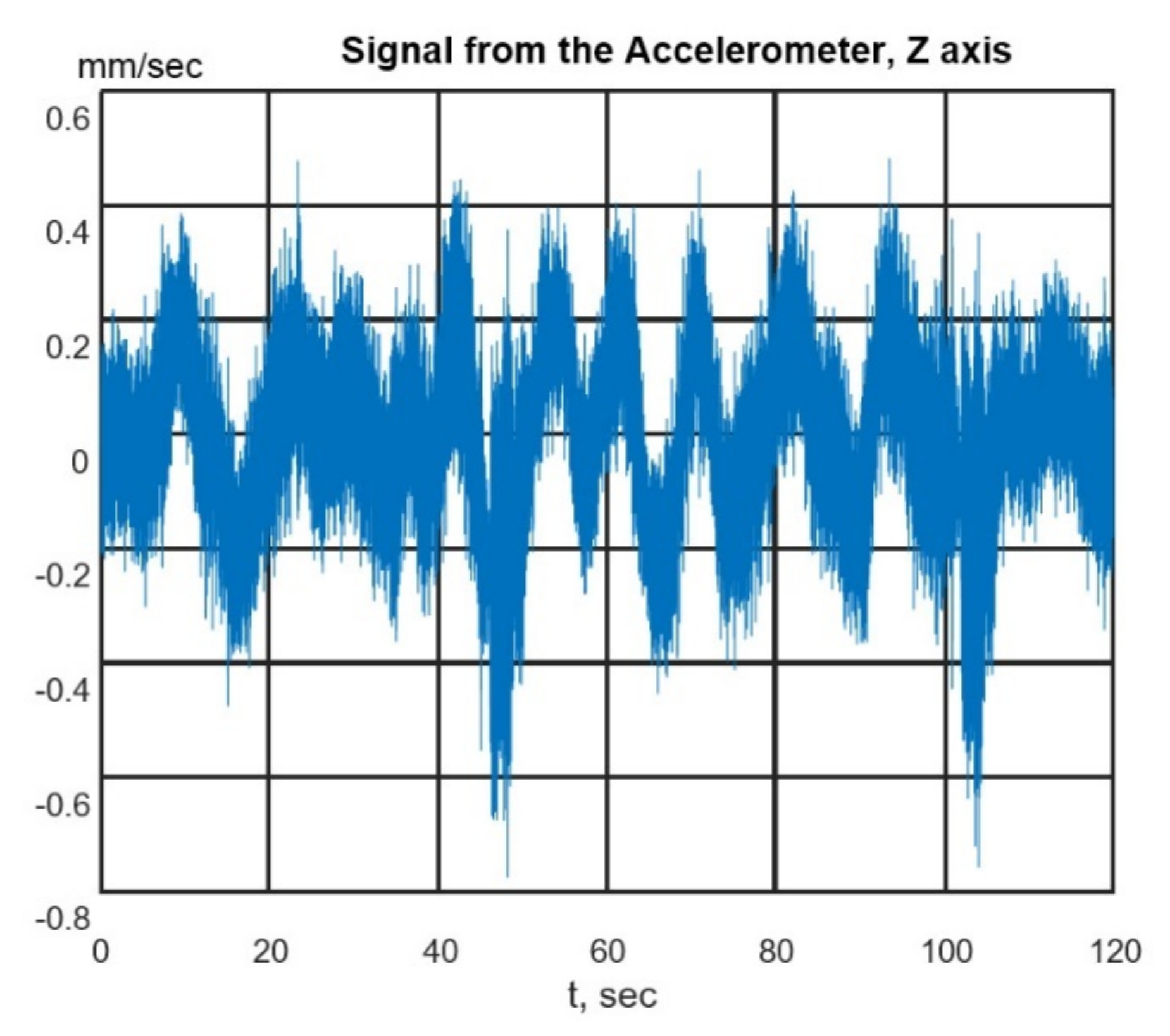
Using this method, simulation of the process of sinkhole formation of the ground base of the railway track in the presence of train noise was carried out (the seismogram taken from the short-period seismic meter ZET 7156 is shown in Figure 10). The electrodes A and B were used as current sources, while the electrodes M and N with corresponding numbers were receivers. The following distances between electrodes were used: between A and B—80 cm, between M1 and N1—70 cm, between M2 and N2—60 cm, between M3 and N3—50 cm, between M4 and N4—40 cm. The frequency of probing electrical signals was 90 Hz, the amplitude of each probing electrical signal was 200 mV, and the analog-to-digital converter was set at a sampling rate of 10,101 Hz.

Figure 10.
Seismogram of the railway track in the presence of train noise.
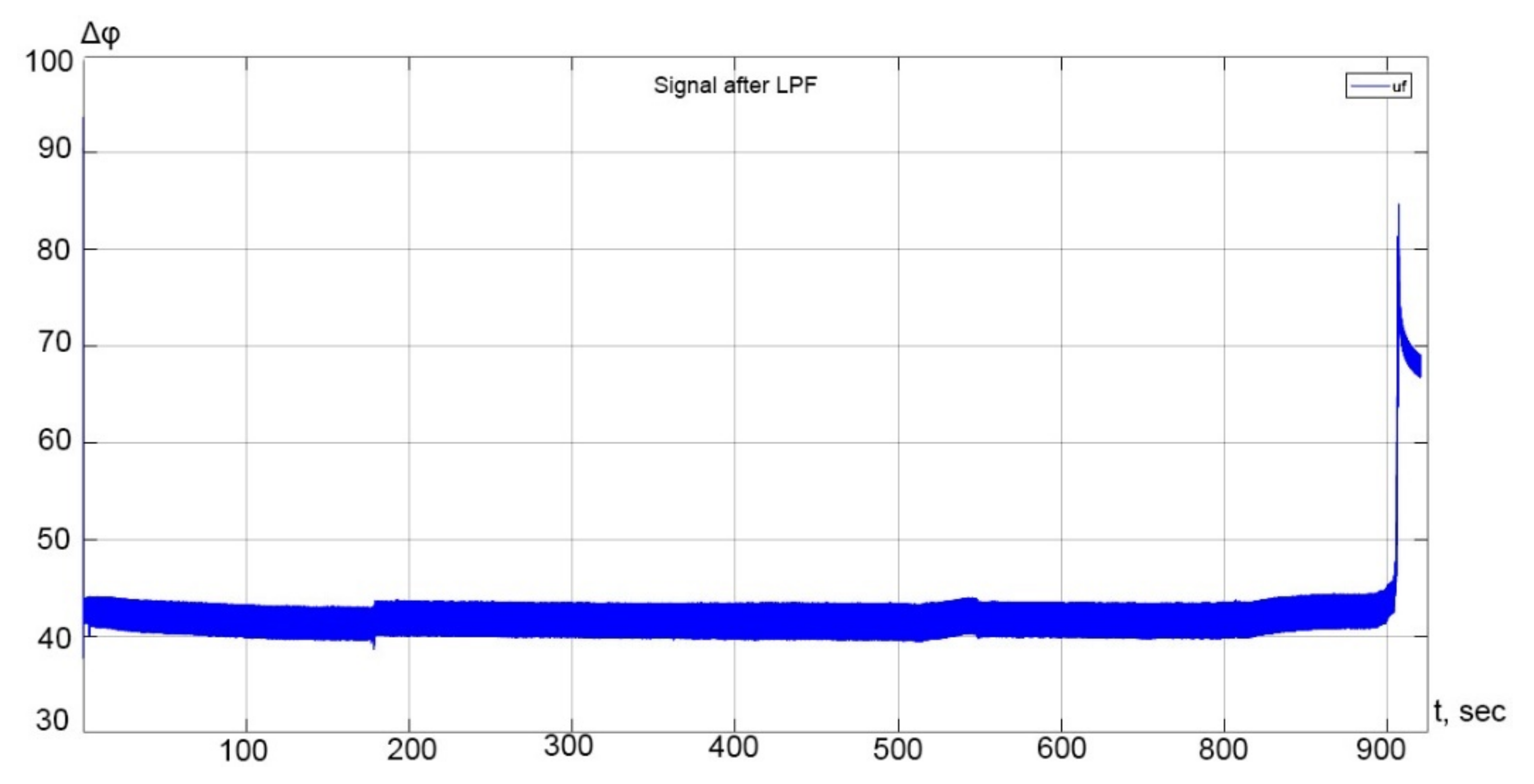
Figure 11 shows an example of a phase image obtained as a result of processing in the time domain for the receiving line M3N3.

Figure 11.
The example of a phase image for the receiving line M3N3, obtained by simulating the process of sinkhole formation of the ground base of the railway track.
The analysis of this process in the time domain makes it possible at an early stage to unambiguously determine the time interval corresponding to the active development of the sinkhole formation process and the direction of its change in time—to localize the source of the deformation process and predict its future dynamics.
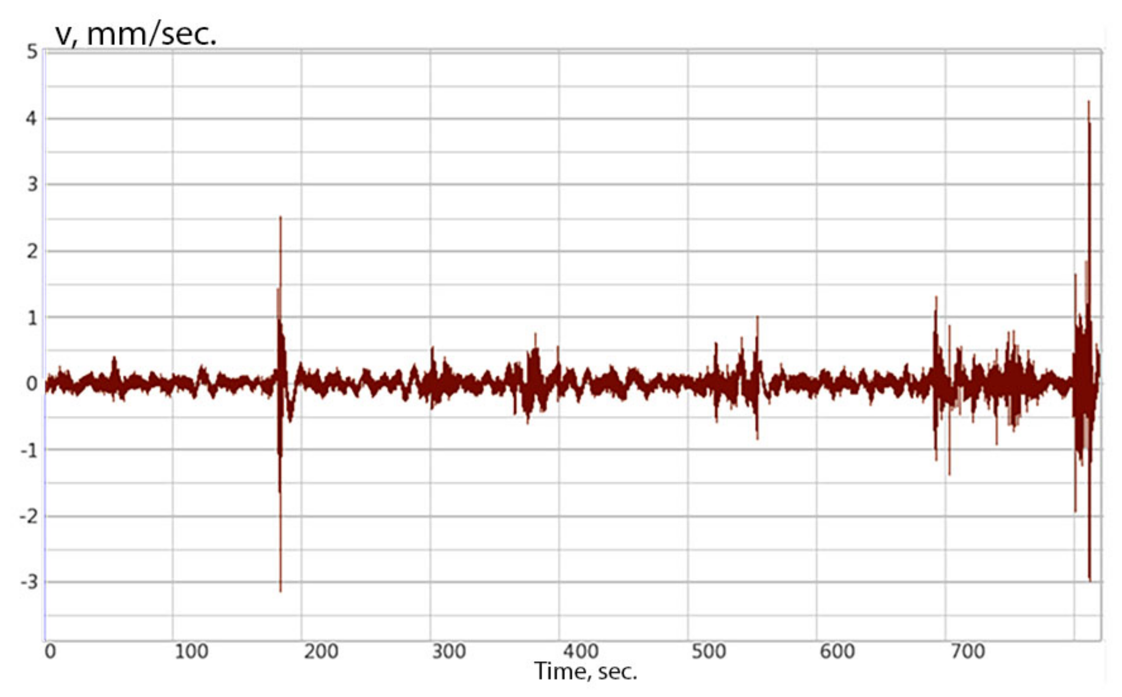
For a comparison, Figure 12 shows a variant of solving a similar problem by the classical seismoacoustic method using a highly sensitive seismometer.

Figure 12.
Seismogram of the process of sinkhole formation of the soil base of the railway roadbed.
A comparison of the two approaches to the control of the underground base of the railway track allows us to conclude that the traditional method allows only the registration of certain geodynamic events in the geological environment without the possibility of their qualitative interpretation, which is eliminated when using the seismoelectric method and monitoring the phase characteristics of the recorded geoelectric signals.
Subsequently, from the recorded signal, it is possible to identify features of soil areas with impaired integrity [31] using Scale Invariant Feature Transform (SIFT)-Support Vector Machine (SVM) methods [35,36,37,38,39,40]. In the presence of high noise level, it is possible to use a neural back propagation network, which will allow achieving 97% accuracy when processing monitoring data [36,37,39].
6. Conclusions
The paper demonstrates that for the diagnostics of the railway roadbed, a number of features not found in traditional engineering geology should be taken into account. The article also theoretically and practically substantiates an integrated approach to solving problems of monitoring the roadbed of a railway on the basis of combining two geophysical methods for monitoring the natural environment: geoelectric and seismoacoustic methods.
From the presented research results, it has been established that the proposed methods for monitoring the railway trackbed have high sensitivity to the primary phase of the soil destruction.
During laboratory modeling, it was found that in the amplitude spectra of the output electrical signals of the investigated geological environment in the presence of an elastic harmonic effect with a frequency of 70 Hz, the frequency of a harmonic electrical signal with a frequency of 40 Hz was observed, which makes it possible to use this effect to obtain more detailed information about the structure of the soil when sounding with electric fields. In laboratory modeling, the obtained phase images for the receiving line of the installation when simulating the process of sinking the soil base of the railway bed confirmed the presence of a transient process that causes a shift in the initial phase of the signal ∆φ = 40° by ~45° (∆φ’ = 85°), that precedes the initial stage of failure.
Moreover, the joint processing of geoelectric and seismoacoustic signals makes it possible to detect heterogeneity in the environment, as well as its depth and its geodynamic variations. The phasometric ground control method allows increasing the efficiency of the railway roadbed monitoring systems, in particular, through the use of vertical electrotomography methods with the possible localization of heterogeneity. In this case, the metrological stability of geodynamic measurements, the insensitivity of the technique to seismic interference, the simplicity of varying the installation size and the organization of three-dimensional soil monitoring is ensured.
The information obtained during the monitoring of the roadbed will improve the reliability and safety of the functioning of railway transport, especially in areas with intensive geodynamic processes.
Author Contributions
Data curation, A.B.; Formal analysis, D.S.; Investigation, A.G.; Supervision, O.K.; Writing—original draft, O.K.; Writing—review & editing, G.V. and Y.Y. All authors have read and agreed to the published version of the manuscript.
Funding
This research was funded by the Ministry of Science and Higher Education of the Russian Federation in accordance with agreement No. 075-15-2020-905 date 16 November 2020 on providing a grant in the form of subsidies from the Federal budget of the Russian Federation. The grant was provided for state support for the establishing and development of a world-class Scientific Center “Agrotechnologies for the Future”.
Institutional Review Board Statement
Not applicable.
Informed Consent Statement
Not applicable.
Acknowledgments
Anastasia Grecheneva has been supported by the Ministry of Science and Higher Education of the Russian Federation in accordance with agreement No. 075-15-2020-905 date 16 November 2020 on providing a grant in the form of subsidies from the Federal budget of the Russian Federation. The grant was provided for state support for the establishing and development of a world-class Scientific Center “Agrotechnologies for the Future”.
Conflicts of Interest
The authors declare no conflict of interest.
References
- Zhai, W.; Wang, K.; Cai, C. Fundamentals of vehicle-track coupled dynamics. Veh. Syst. Dyn. 2009, 47, 1349–1376. [Google Scholar] [CrossRef]
- Song, Y.; Wang, Z.; Liu, Z.; Wang, R. A spatial coupling model to study dynamic performance of pantograph-catenary with vehicle-track excitation. Mech. Syst. Signal Process. 2021, 151, 107336. [Google Scholar] [CrossRef]
- Yan, H.; Gao, C.; Elzarka, H.; Mostafa, K.; Tang, W. Risk assessment for construction of urban rail transit projects. Saf. Sci. 2019, 118, 583–594. [Google Scholar] [CrossRef]
- Arcos, R.; Soares, P.J.; Costa, P.A.; Godinho, L. An experimental/numerical hybrid methodology for the prediction of railway-induced ground-borne vibration on buildings to be constructed close to existing railway infrastructures: Numerical validation and parametric study. Soil Dyn. Earthq. Eng. 2021, 150, 106888. [Google Scholar] [CrossRef]
- Draft Environmental Impact Report, Preston Property Residential Project State Clearinghouse No: 2012022075; City of Milpitas, CA, USA, 15 November 2012. Available online: http://www.ci.milpitas.ca.gov/_pdfs/plan_eir_PrestonPropertyAppendices-Part1.pdf (accessed on 15 November 2012).
- Cheverikin, A.V. Modern methods of monitoring geodynamic processes in oil and gas production areas, XXI century. Technosphere Secur. 2019, 13, 122–133. [Google Scholar]
- Brough, M.; Stirling, A.; Ghataora, G.; Madelin, K. Evaluation of railway trackbed and formation: A case study. NDT E Int. 2003, 36, 145–156. [Google Scholar] [CrossRef]
- Fisseha, S.; Mewa, G.; Haile, T. Refraction seismic complementing electrical method in subsurface characterization for tunneling in soft pyroclastic, (a case study). Heliyon 2021, 7, e07680. [Google Scholar] [CrossRef]
- De Pasquale, G.; Linde, N.; Greenwood, A. Joint probabilistic inversion of DC resistivity and seismic refraction data applied to bedrock/regolith interface delineation. J. Appl. Geophys. 2019, 170, 103839. [Google Scholar] [CrossRef]
- Lee, S.C.H.; Noh, K.A.M.; Zakariah, M.N.A. High-resolution electrical resistivity tomography and seismic refraction for groundwater exploration in fracture hard rocks: A case study in Kanthan, Perak, Malaysia. J. Asian Earth Sci. 2021, 218, 104880. [Google Scholar] [CrossRef]
- An, L.; Hao, Y.; Yeh, T.C.J.; Liu, Y.; Liu, W.; Zhang, B. Simulation of karst spring discharge using a combination of time–frequency analysis methods and long short-term memory neural networks. J. Hydrol. 2020, 589, 125320. [Google Scholar] [CrossRef]
- Zheng, Y.; He, S.; Yu, Y.; Zheng, J.; Zhu, Y.; Liu, T. Characteristics, challenges and countermeasures of giant karst cave: A case study of Yujingshan tunnel in high-speed railway. Tunn. Undergr. Space Technol. 2021, 114, 103988. [Google Scholar] [CrossRef]
- Shangxin, F.; Yufei, Z.; Yujie, W.; Shanyong, W.; Ruilang, C. A comprehensive approach to karst identification and groutability evaluation—A case study of the Dehou reservoir, SW China. Eng. Geol. 2020, 269, 105529. [Google Scholar] [CrossRef]
- Drahor, M.G. Identification of gypsum karstification using an electrical resistivity tomography technique: The case-study of the Sivas gypsum karst area (Turkey). Eng. Geol. 2019, 252, 78–98. [Google Scholar] [CrossRef]
- Kaufmann, G.; Romanov, D. Modelling long-term and short-term evolution of karst in vicinity of tunnels. J. Hydrol. 2020, 581, 124282. [Google Scholar] [CrossRef]
- Pazzi, V.; Morelli, S.; Fanti, R. A review of the advantages and limitations of geophysical investigations in Landslide studies. Int. J. Geophys. 2019, 2019, 2983087. [Google Scholar] [CrossRef] [Green Version]
- Mahmoodzadeh, A.; Mohammadi, M.; Ali, H.F.H.; Abdulhamid, S.N.; Ibrahim, H.H.; Noori, K.M.G. Dynamic prediction models of rock quality designation in tunneling projects. Transp. Geotech. 2021, 27, 100497. [Google Scholar] [CrossRef]
- Zhu, H.; Yan, J.; Liang, W. Challenges and Development Prospects of Ultra-Long and Ultra-Deep Mountain Tunnels. Engineering 2019, 5, 384–392. [Google Scholar] [CrossRef]
- Chawla, S.; Shahu, J.T.; Kumar, S. Analysis of cyclic deformation and post-cyclic strength of reinforced railway tracks on soft subgrade. Transp. Geotech. 2021, 28, 100535. [Google Scholar] [CrossRef]
- Baknin, M.D.; Surzhik, D.I.; Vasilyev, G.S.; Dorofeev, N.V. The modeling of the Phase-Metric Method of the Geoelectrical Control of Oil Sludge Straits. IOP Conf. Ser. Earth Environ. Sci. 2020, 459, 042085. [Google Scholar] [CrossRef]
- Yun, B. Design of Underground Structures. In Underground Engineering; Yun, B., Ed.; Academic Press: Cambridge, MA, USA, 2019; pp. 47–115. ISBN 9780128127025. [Google Scholar]
- Patel, A. Case examples of some geotechnical applications. In Geotechnical Investigations and Improvement of Ground Conditions; Woodhead Publishing Series in Civil and Structural Engineering; Patel, A., Ed.; Woodhead Publishing: Cambridge, UK, 2019; pp. 167–191. ISBN 9780128170489. [Google Scholar]
- Maxim, B.; Artem, B.; Dmitry, S.; Oleg, K. Geotechnical monitoring of the foundations of structures based on integrated seismoelectric measurements in conditions of karst hazard. In Proceedings of the 20th International Multidisciplinary Scientific GeoConference Proceedings SGEM 2020, Albena, Bulgaria, 16–25 August 2020; Volume 20, pp. 559–566. [Google Scholar]
- Kuzichkin, O.; Grecheneva, A.; Bykov, A.; Dorofeev, N.; Surzhik, D. Methods and algorithms of joint processing of geoelectric and seismoacoustic signals in real time. In Proceedings of the SGEM2018 Conference, Albena, Bulgaria, 2–8 July 2018; Volume 18, pp. 877–884. [Google Scholar]
- Kuzichkin, O.R.; Vasilyev, G.S.; Grecheneva, A.V.; Mikhaleva, E.V.; Baknin, M.D.; Surzhik, D.I. Application of phase-metric compensation method for geoelectric control of near-surface geodynamic processes. Bull. Electr. Eng. Inform. 2020, 9, 898–905. [Google Scholar] [CrossRef]
- Kuzichkin, O.; Vasilyev, S.; Grecheneva, A.; Mikhaleva, V.; Maxim, B. Application of phase-metric measuring system for geodynamic control of karst processes. J. Eng. Appl. Sci. 2017, 12, 6858–6863. [Google Scholar]
- Kuzichkin, O.R.; Vasilyev, G.S.; Baknin, M.D.; Surzhik, D.I. The phase-metric method of isolating the information component in the distributed processing of geoelectric signals in geoecological monitoring systems. J. Adv. Res. Dyn. Control Syst. 2020, 12, 463–471. [Google Scholar]
- Kuzichkin, O.; Dorofeev, N.; Grecheneva, A.; Bykov, A.; Romanov, R. The use of vertical electrical sounding by the method of two components for allocation of an initial phase of a landslide. In Proceedings of the SGEM2017 Conference, Albena, Bulgaria, 29 June–5 July 2017; Volume 17, pp. 1025–1032. [Google Scholar]
- Kovalenko, A.O.; Bykov, A.A.; Kuzichkin, O.R. Railway Traffic Monitoring System by Seismic Methods. Helix 2020, 10, 218–224. [Google Scholar] [CrossRef]
- Aliouache, M.; Wang, X.; Jourde, H.; Huang, Z.; Yao, J. Incipient karst formation in carbonate rocks: Influence of fracture network topology. J. Hydrol. 2019, 575, 824–837. [Google Scholar] [CrossRef]
- Zhang, N.; Zhou, A.; Pan, Y.; Shen, S.L. Measurement and prediction of tunnelling-induced ground settlement in karst region by using expanding deep learning method. Measurement 2021, 183, 109700. [Google Scholar] [CrossRef]
- Eppelbaum, L. Environmental Geophysics. In Computational Geophysics, Geophysical Potential Fields; Eppelbaum, L.V., Ed.; Elsevier: Amsterdam, The Netherlands, 2019; Volume 2, pp. 311–364. [Google Scholar]
- Jeannin, P.Y.; Artigue, G.; Butscher, C.; Chang, Y.; Charlier, J.; Duran, L.; Gill, L.; Hartmann, A.; Johannet, A.; Jourde, H.; et al. Karst modelling challenge 1: Results of hydrological modelling. J. Hydrol. 2021, 600, 126508. [Google Scholar] [CrossRef]
- Wang, X.; Aliouache, M.; Wang, Y.; Lei, Q.; Jourde, H. The role of aperture heterogeneity in incipient karst evolution in natural fracture networks: Insights from numerical simulations. Adv. Water Resour. 2021, 156, 104036. [Google Scholar] [CrossRef]
- Soloviev, V. Fintech Ecosystem in Russia. In Proceedings of the 2018 11th International Conference; Management of Large-Scale System Development, MLSD, Moscow, Russia, 1–3 October 2018. [Google Scholar] [CrossRef]
- Sebyakin, A.; Soloviev, V.; Zolotaryuk, A. Spatio-Temporal Deepfake Detection with Deep Neural Networks. In Proceedings of the 16th International Conference on Information: iConference 2021: Diversity, Divergence, Dialogue, Beijing, China, 17–31 March 2021; Lecture Notes in Computer Science (including Subseries Lecture Notes in Artificial Intelligence and Lecture Notes in Bioinformatics); Springer: Cham, Switzerland; Volume 12645, pp. 78–94. [CrossRef]
- Gataullin, T.M.; Gataullin, S.T.; Ivanova, K.V. Modeling an Electronic Auction. In Proceedings of the Institute of Scientific Communications Conference: ISC 2020: “Smart Technologies” for Society, State and Economy, Volgograd, Russia, 19–20 March 2020; 155, pp. 1108–1117. [Google Scholar] [CrossRef]
- Gataullin, T.M.; Gataullin, S.T. Best Economic Approaches under Conditions of Uncertainty. In Proceedings of the 2018 Eleventh International Conference “Management of large-scale system development” (MLSD), Moscow, Russia, 1–3 October 2018. [Google Scholar] [CrossRef]
- Dogadina, E.P.; Smirnov, M.V.; Osipov, A.V.; Suvorov, S.V. Evaluation of the forms of education of high school students using a hybrid model based on various optimization methods and a neural network. Informatics 2021, 8, 46. [Google Scholar] [CrossRef]
- Tatarintsev, M.; Korchagin, S.; Nikitin, P.; Gorokhova, R.; Bystrenina, I.; Serdechnyy, D. Analysis of the forecast price as a factor of sustainable development of agriculture. Agronomy 2021, 11, 1235. [Google Scholar] [CrossRef]

Publisher’s Note: MDPI stays neutral with regard to jurisdictional claims in published maps and institutional affiliations. |
© 2021 by the authors. Licensee MDPI, Basel, Switzerland. This article is an open access article distributed under the terms and conditions of the Creative Commons Attribution (CC BY) license (https://creativecommons.org/licenses/by/4.0/).