You are currently viewing a new version of our website. To view the old version click .

ISPRS International Journal of Geo-Information, Volume 12, Issue 3

March 2023 - 53 articles

Cover Story: 
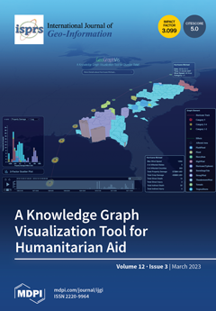
GeoGraphVis is a graph-powered visualization tool developed to guide situational awareness during natural disasters and to support disaster relief efforts, such as the distribution of medical and other humanitarian supplies. The cover image shows the trajectory of Hurricane Michael and the property damages caused to different counties. The colors of the 3D columns on the map are used to differentiate the damages caused by the cascading after-effects of Michael, such as floods and storm surges. The statistics chart shows the number of counties suffering from different levels of property damage. GeoGraphVis tools build upon the expressive power of ontologies and a bespoke knowledge graph to semantically connect multi-faceted datasets and address complex spatial decision-making problems in a data-driven manner. View this paper
  • Issues are regarded as officially published after their release is announced to the table of contents alert mailing list .
  • You may sign up for email alerts to receive table of contents of newly released issues.
  • PDF is the official format for papers published in both, html and pdf forms. To view the papers in pdf format, click on the "PDF Full-text" link, and use the free Adobe Reader to open them.

Articles (53)

  • Article
  • Open Access
13 Citations
5,202 Views
18 Pages

With the rapid development of urbanization, fire risk factors have increased greatly, indicating a higher requirement for urban firefighting security. Fire rescue capabilities can be effectively improved by the scientific layout of fire stations, and...

  • Article
  • Open Access
2 Citations
7,673 Views
15 Pages

Physical activity (PA) plays a vital role in children’s physical and mental health. The built, natural, and socio-demographic environmental variables affect children’s PA behaviors in various ways. However, few studies focus on systematic...

  • Article
  • Open Access
5 Citations
4,475 Views
14 Pages

With the rapid development of information technology, virtual reality and gesture interaction have been gradually applied in the research and development of map navigation systems. Traditional visualization methods are no longer suitable for this nov...

  • Article
  • Open Access
13 Citations
4,607 Views
18 Pages

Lane line detection is a fundamental and critical task for geographic information perception of driverless and advanced assisted driving. However, the traditional lane line detection method relies on manual adjustment of parameters, and has poor univ...

  • Article
  • Open Access
2 Citations
2,687 Views
22 Pages

Based on the data of existing warehouse supermarkets in Liaoning Province, China, spatial autocorrelation analysis, kernel density analysis, composite correlation coefficient analysis and other methods have been adopted to analyze their spatial-tempo...

  • Article
  • Open Access
16 Citations
11,399 Views
13 Pages

Measuring Traffic Congestion with Novel Metrics: A Case Study of Six U.S. Metropolitan Areas

  • Jeong Seong,
  • Yunsik Kim,
  • Hyewon Goh,
  • Hyunmin Kim and
  • Ana Stanescu

Quantifying traffic congestion is a critical task for transportation planning and research. Numerous metrics have been developed, mainly focusing on changes in vehicle speeds, their extents, and travel time. In this study, new metrics are presented u...

  • Article
  • Open Access
9 Citations
3,958 Views
20 Pages

Flood Monitoring in the Middle and Lower Basin of the Yangtze River Using Google Earth Engine and Machine Learning Methods

  • Jingming Wang,
  • Futao Wang,
  • Shixin Wang,
  • Yi Zhou,
  • Jianwan Ji,
  • Zhenqing Wang,
  • Qing Zhao and
  • Longfei Liu

Under the background of intensified human activities and global climate warming, the frequency and intensity of flood disasters have increased, causing many casualties and economic losses every year. Given the difficulty of mountain shadow removal fr...

  • Article
  • Open Access
6 Citations
3,367 Views
23 Pages

Leveraging Deep Convolutional Neural Network for Point Symbol Recognition in Scanned Topographic Maps

  • Wenjun Huang,
  • Qun Sun,
  • Anzhu Yu,
  • Wenyue Guo,
  • Qing Xu,
  • Bowei Wen and
  • Li Xu

Point symbols on a scanned topographic map (STM) provide crucial geographic information. However, point symbol recognition entails high complexity and uncertainty owing to the stickiness of map elements and singularity of symbol structures. Therefore...

  • Article
  • Open Access
2 Citations
2,758 Views
20 Pages

Dynamic Weighted Road Network Based Multi-Vehicles Navigation and Evacuation

  • Zhi Cai,
  • Tao Wang,
  • Qing Mi,
  • Xing Su,
  • Limin Guo and
  • Zhiming Ding

Many events such as large-scale activities and traffic accidents could cause an increase in vehicle density in an area, which makes the evacuation of vehicles important. However, the existing evacuation methods are not efficient limit to multi-vehicl...

  • Article
  • Open Access
6 Citations
3,138 Views
22 Pages

The application of AR to explore augmented map representation has become a research hotspot due to the growing application of AR in maps and geographic information in addition to the rising demand for automated map interpretation. Taking the AR map a...

of 6

Get Alerted

Add your email address to receive forthcoming issues of this journal.

XFacebookLinkedIn
ISPRS Int. J. Geo-Inf. - ISSN 2220-9964