

Method for Applying Crowdsourced Street-Level Imagery Data to Evaluate Street-Level Greenness

Abstract
1. Introduction
1.1. Background
1.2. Objectives and Research Structure
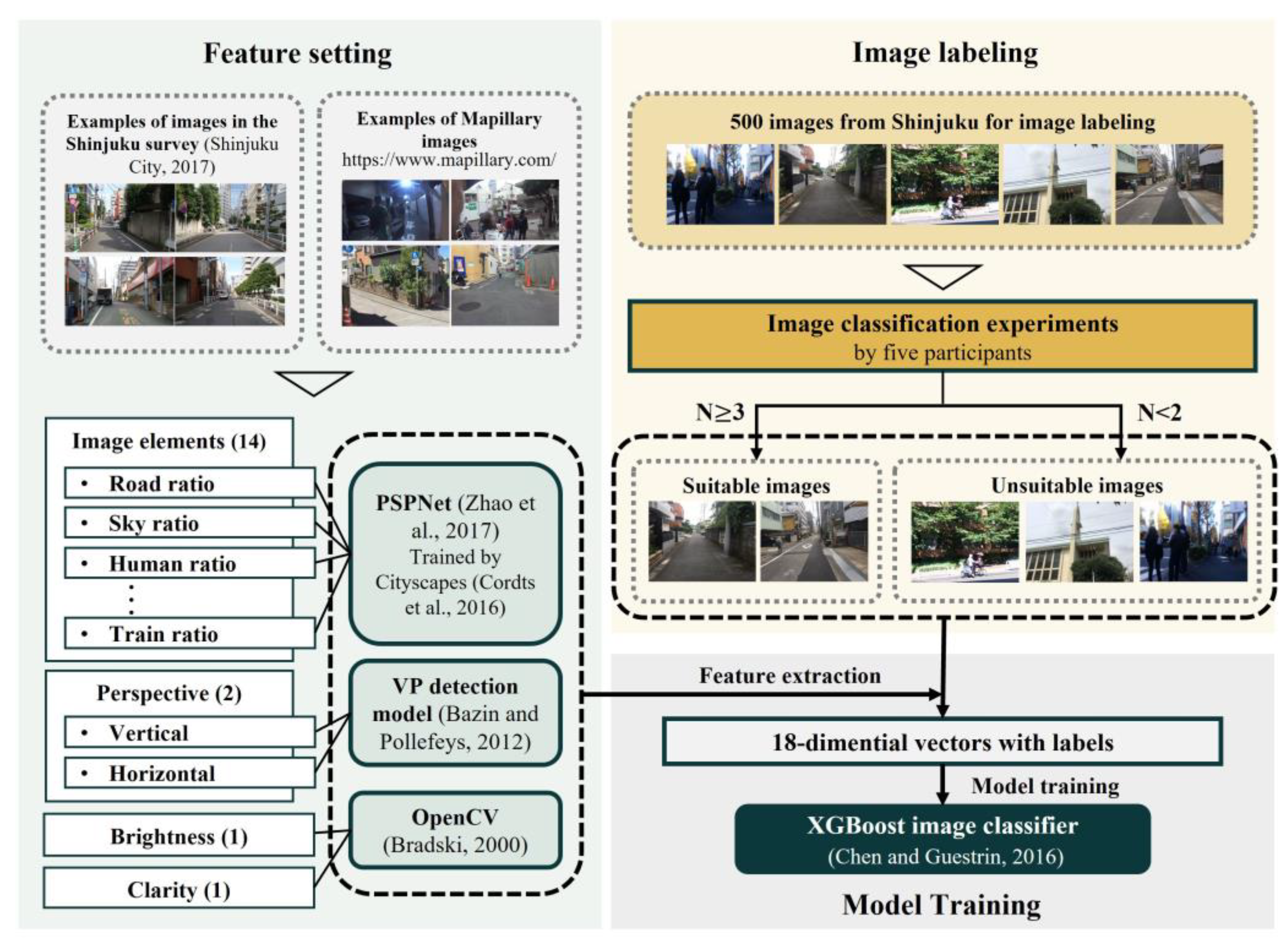
2. Materials and Methods
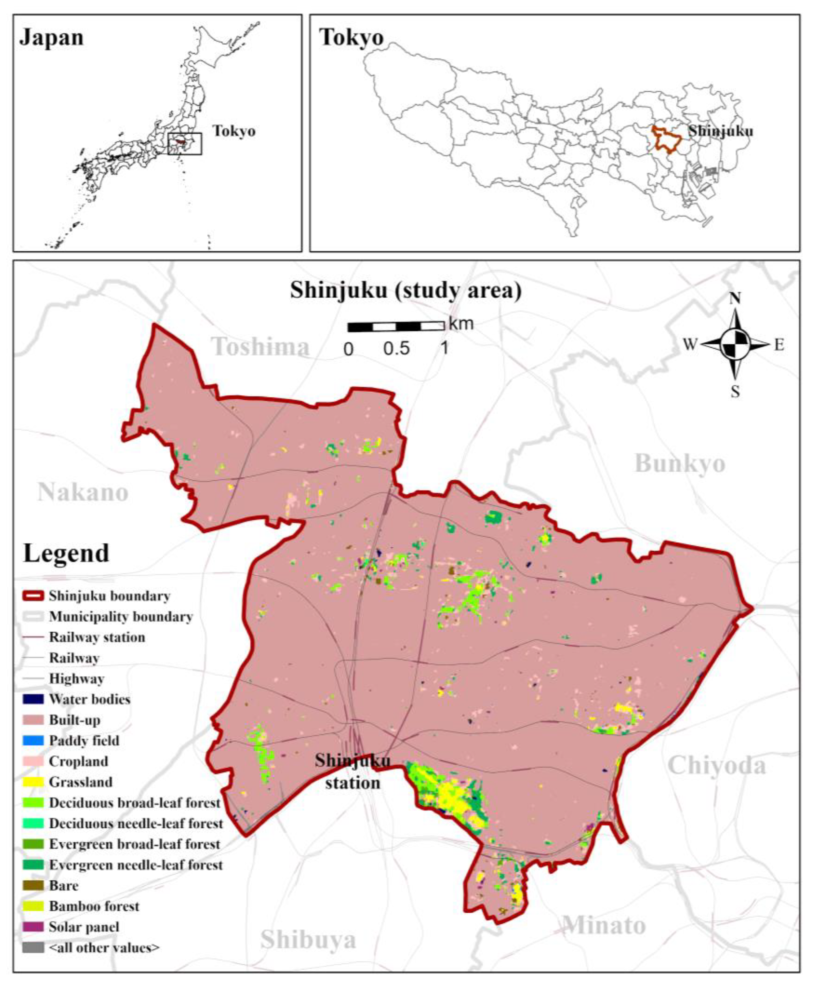
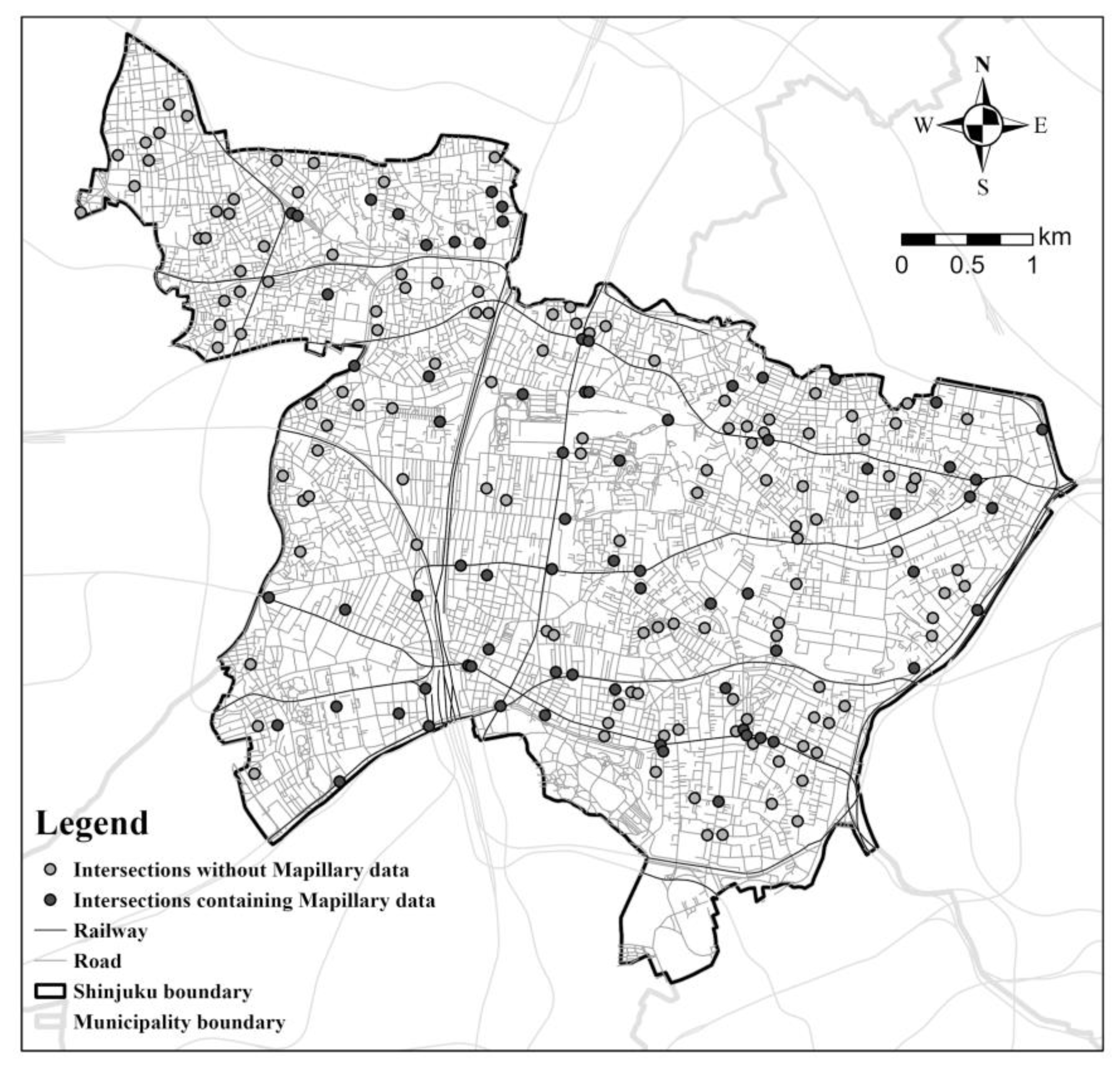
2.1. Overview of the Analysis and Study Area
2.2. Data Description and Extraction
2.2.1. Mapillary Imagery Data
2.2.2. Reference Data for Accuracy Evaluation
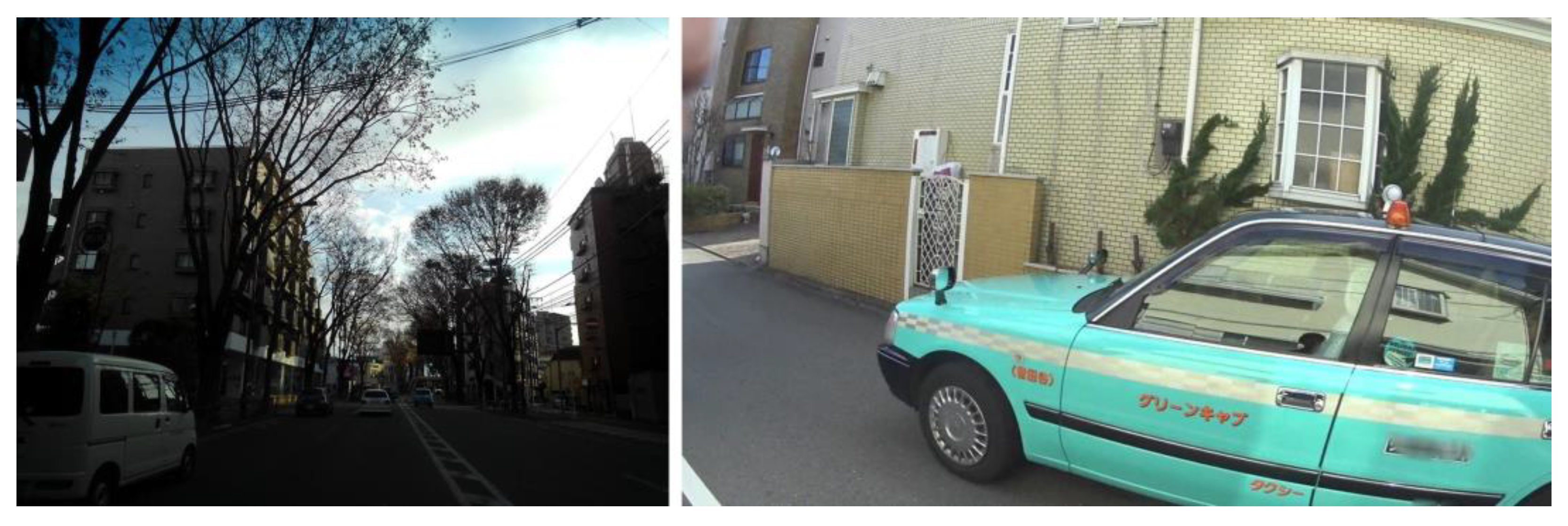
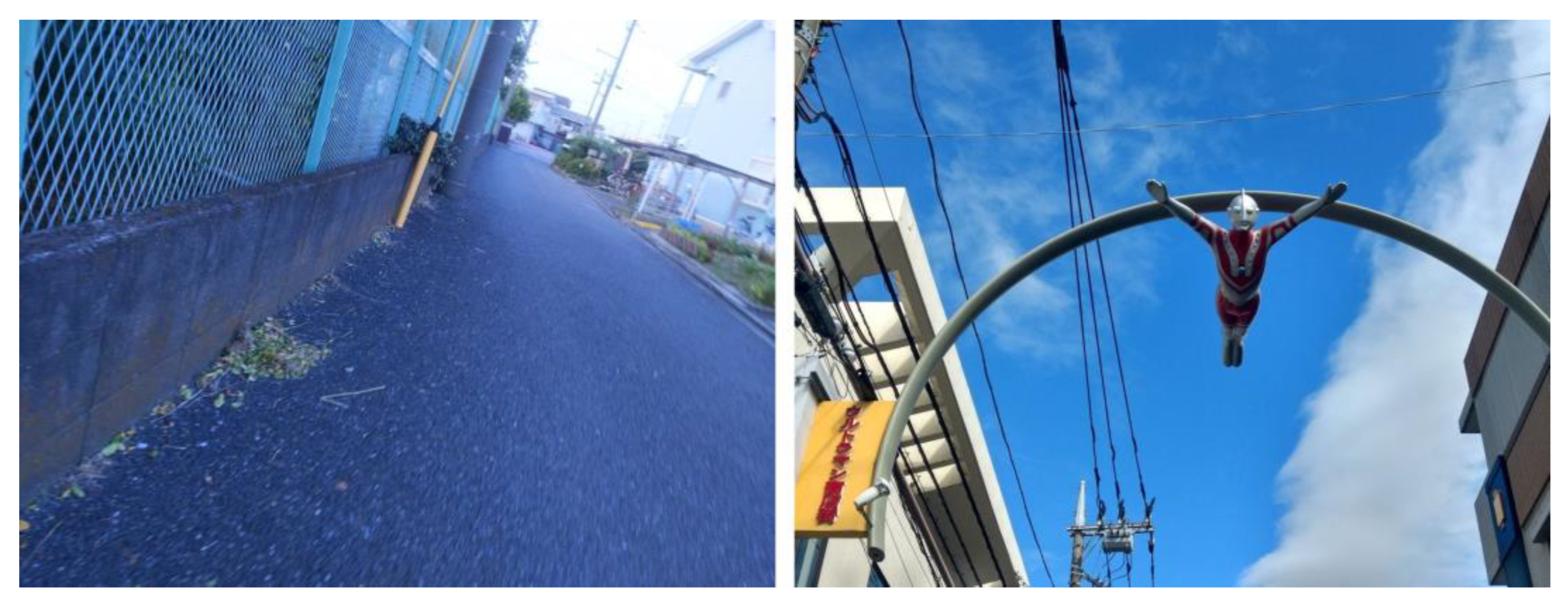
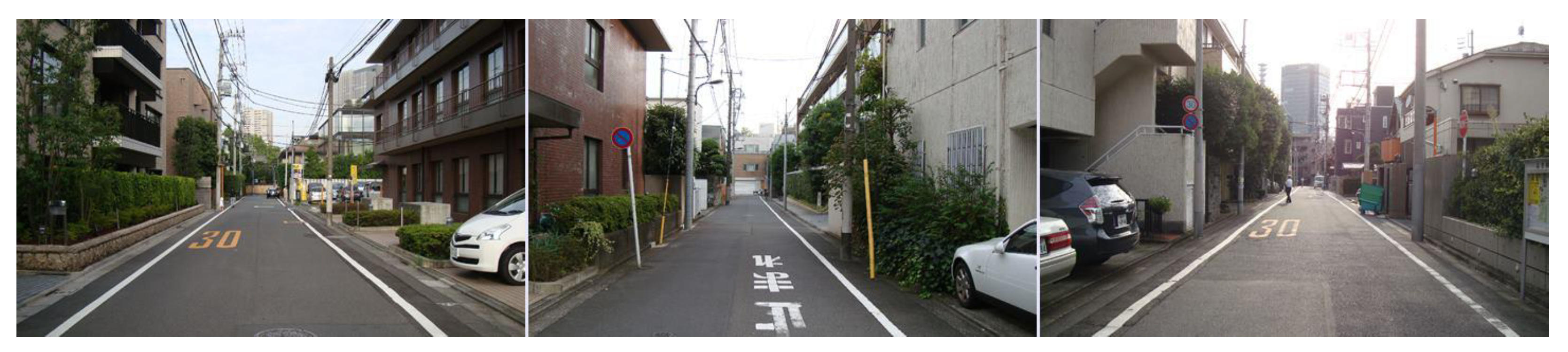
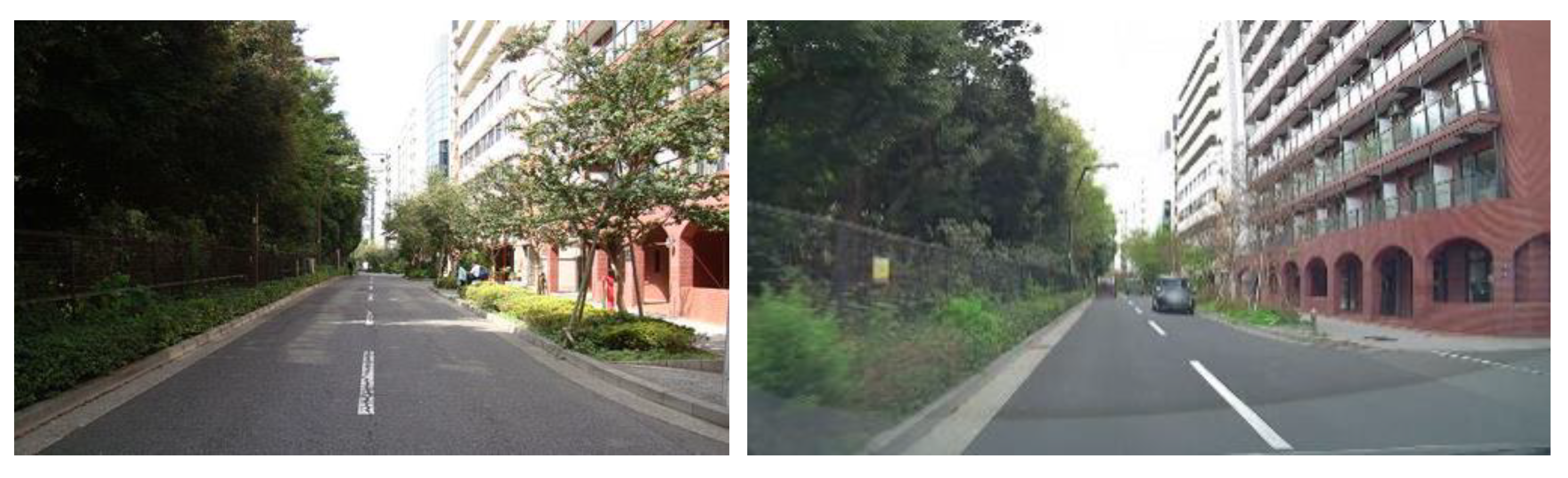
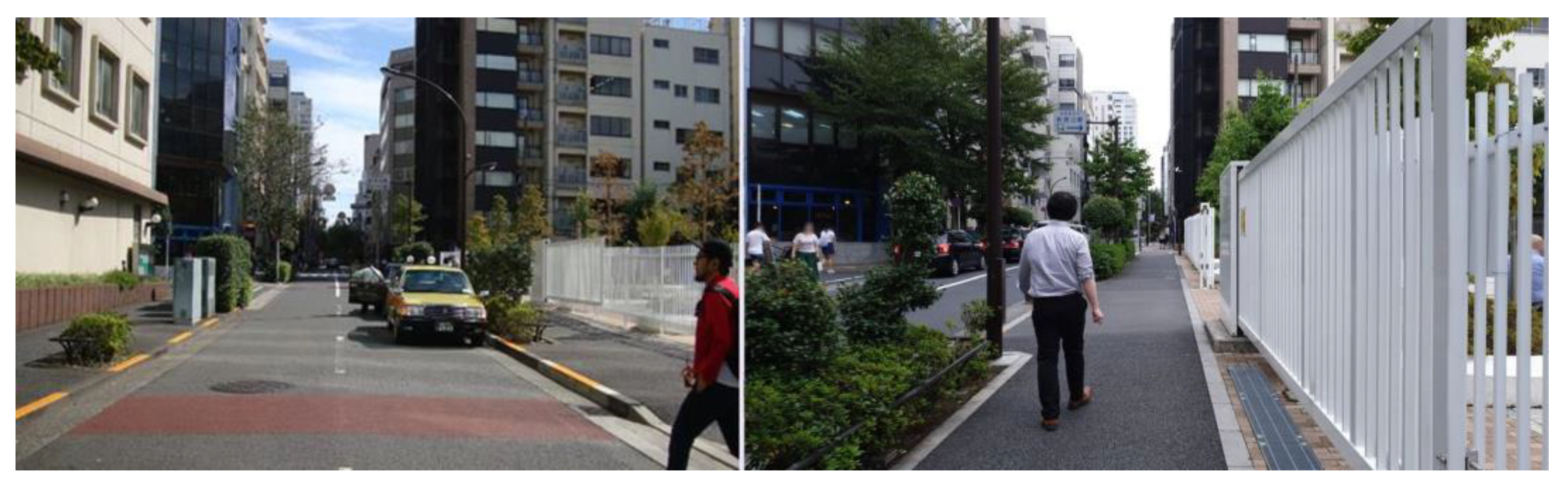
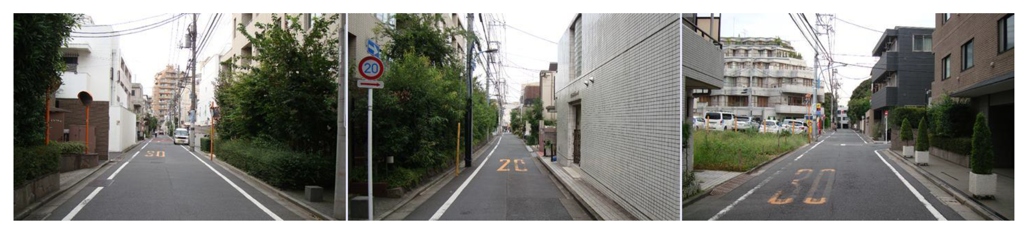
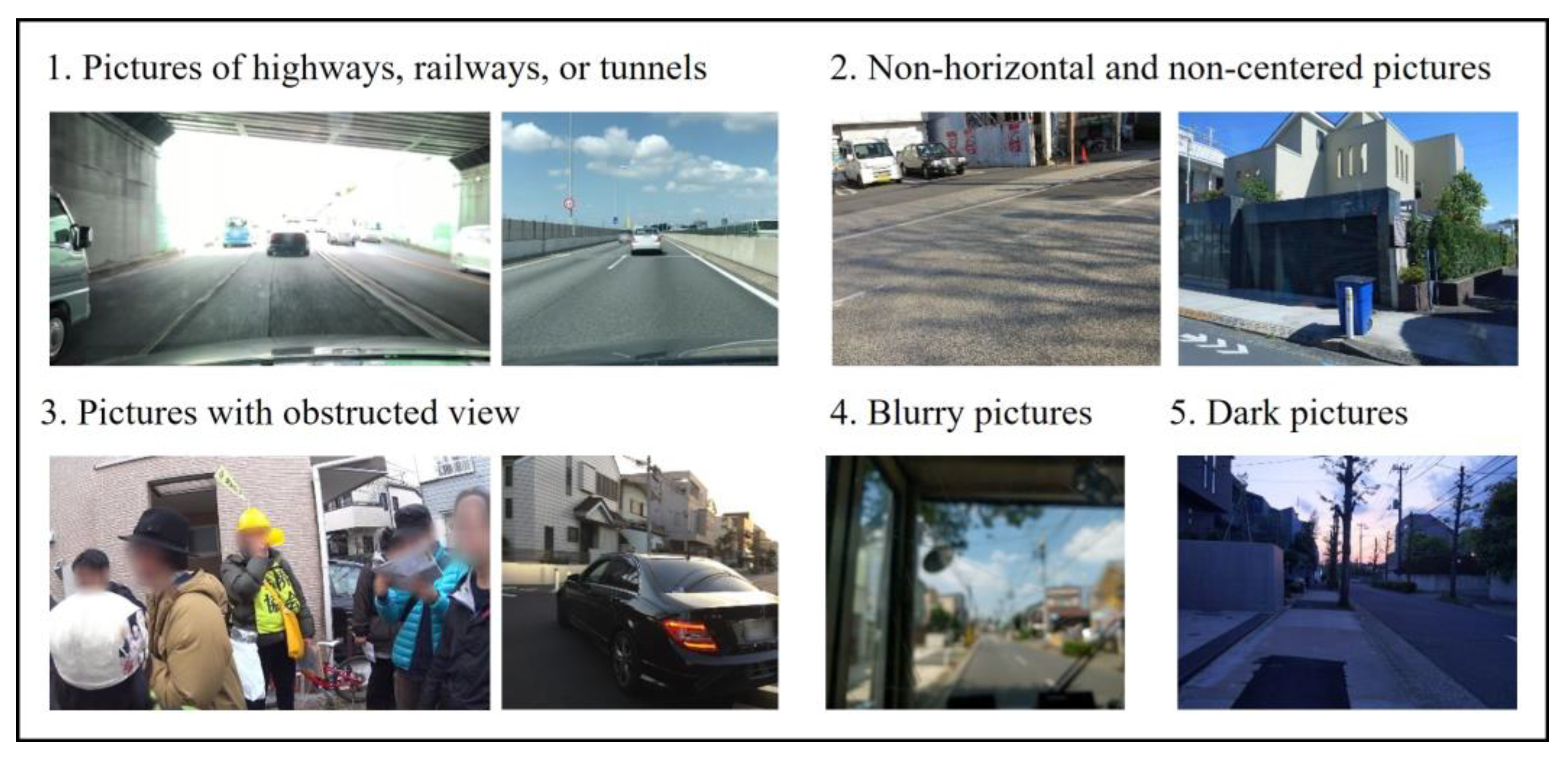
2.3. Image Filtering Method
2.4. Accuracy Evaluation
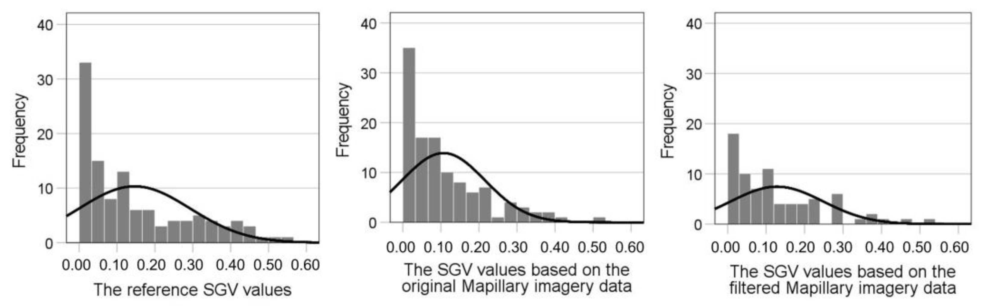
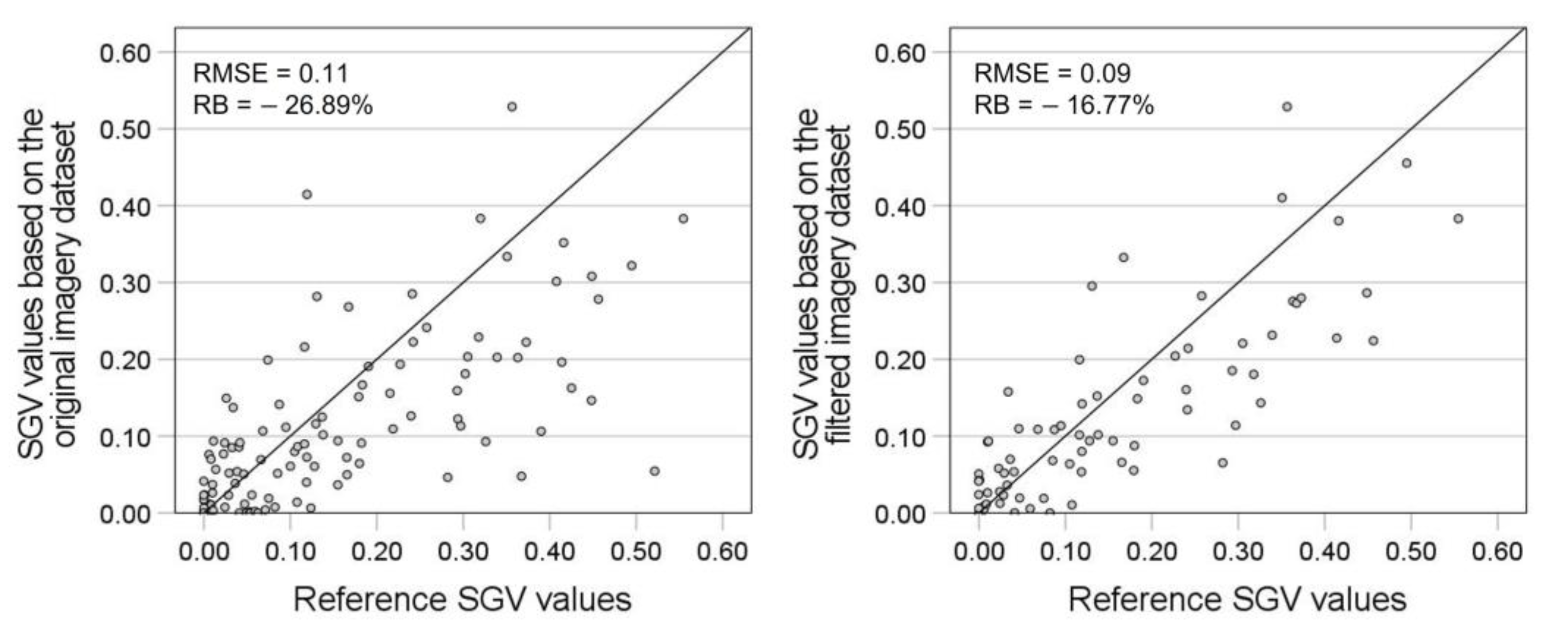
3. Results
3.1. Image Classification Method
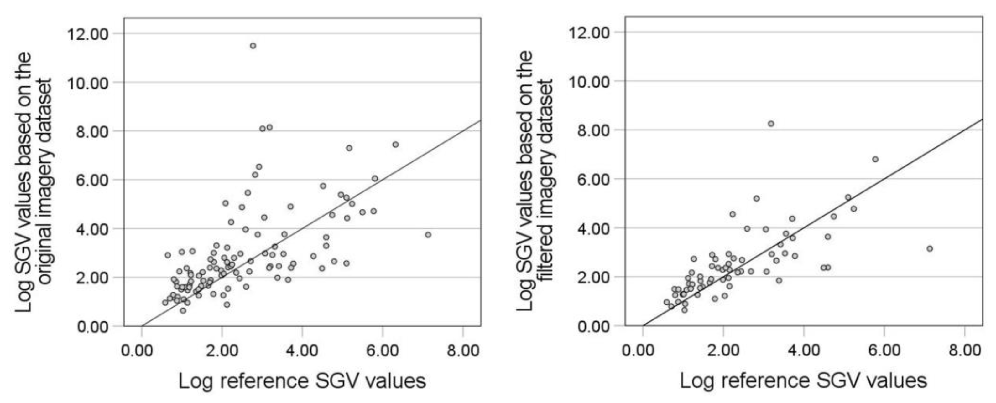
3.2. Accuracy Evaluation
4. Discussion
5. Conclusions
Supplementary Materials
Author Contributions
Funding
Data Availability Statement
Conflicts of Interest
Appendix A

| Authors | Year | Study Area | Purpose | Imagery Data | Panorama | Data Collector |
|---|---|---|---|---|---|---|
| Yang et al. [21] | 2009 | Berkeley, United States | To develop the Green View Index (GVI) to evaluate the visibility of urban forests | - | No | researcher |
| Li et al. [29] | 2015 | New York, United States | To propose a modified GVI formula using GSV images | GSV 1 | Yes | company |
| Li et al. [50] | 2015 | Hartford, United States | To explore the distribution of street greenery and its association with residents’ socioeconomic conditions | GSV | Yes | company |
| Long and Liu [51] | 2017 | 245 major Chinese cities | To propose an automatic method to determine street greenery and analyze the distribution of street greenery | TSV 2 | Yes | company |
| Jiang et al. [18] | 2017 | The Midwestern United States | To assess associations among two remotely sensed and three eye-level tree cover density measures | - | Yes | researcher |
| Seiferling et al. [52] | 2017 | New York and Boston, United States | To test a novel application of computer vision to quantify urban tree cover at the street-level | GSV | Yes | company |
| Dong, Zhang, and Zhao [53] | 2018 | Beijing, China | To quantify street greenery in study area, analyze the relations with road parameters, and compare the visual greenery of different road types | TSV | Yes | company |
| Lu, Sarkar, and Xiao [54] | 2018 | Hong Kong, China | To develop methods and tools to assess the availability of eye-level street greenery and investigate the effect of street-level greenery on walking behavior | GSV | Yes | company |
| Villeneuve et al. [6] | 2018 | Ottawa, Canada | To assess associations between greenness, walkability, recreational physical activity, and health (comparing the NDVI with the GSV measure of vegetation) | GSV | Yes | company |
| Zhang and Dong [55] | 2018 | Beijing, China | To investigate the impacts of street visible greenery on housing prices | TSV | Yes | company |
| larkin and Hystad [19] | 2019 | Portland, United States | To evaluate GSV-based green space exposure measures as new approach for health research | GSV | Yes | company |
| Lu [56] | 2019 | Hong Kong, China | To assess both the quantity and quality of street greenery and investigate the association between them and physical activity | GSV | Yes | company |
| Yang et al. [57] | 2019 | Hong Kong, China | To examine the associations of urban greenery and older adults’ physical activity | GSV | Yes | company |
| Ye et al. [58] | 2019 | Shanghai, China | To measure the potential economic effect of street greenery | BTV 3 | Yes | company |
| Ye et al. [32] | 2019 | Singapore | To propose an approach for quantifying the daily exposure of urban residents to eye-level street greenery | GSV | Yes | company |
| Chen et al. [59] | 2020 | Shenzhen, China | To explore the influence of greening factors on the use of shared bicycles | TSV | Yes | company |
| Chen, Zhou, and Li [60] | 2020 | The Pearl River Delta Urban Agglomeration, China | To quantify green view values and explore their potentially influential factors | BTV | Yes | company |
| Kumakoshi et al. [61] | 2020 | Yokohama, Japan | To propose an improved greenery visibility indicator (standardized GVI) and quantify the relation between sGVI and other green metrics | GSV | Yes | company |
| Tong et al. [62] | 2020 | Nanjing, China | To assess street greenery using multiple indicators | TSV | Yes | company |
| Wang et al. [63] | 2020 | Shenzhen, China | To explore the relationship between eye-level greenness and cycling behaviors | TSV | Yes | company |
| Wu et al. [64] | 2020 | Beijing, China | To investigate the effect of street greenery on active travel considering road classification | BTV | Yes | company |
| Zang et al. [65] | 2020 | Hong Kong, China | To explore the relationship between urban greenery and walking behaviors of older adults | BTV | Yes | company |
| Ki and Lee [66] | 2021 | Seoul, Korea | To examine GVI (the difference with traditional greenery variables) and explore its associations with walking activities | GSV | Yes | company |
| Li [67] | 2020 | New York, United States | To map and analyze the spatial distribution and temporal change in the GVI | GSV | Yes | company |
| Xia et al. [68] | 2021 | Osaka, Japan | To develop a method to determine the greenery amount of street view images and propose the Panoramic View Green View Index for measuring the visible street-level greenery | GSV | Yes | company |
| Yang et al. [69] | 2021 | Hong Kong, China | To examine the effects of streetscape greenery on the walking behavior of older adults | GSV | Yes | company |
| Yang et al. [70] | 2021 | Hong Kong, China | To develop a novel method to assess both the quantity and quality of park greenery from eye-level photographs of parks and explore the associations with park usage | - | No | researcher |
| Zhang, Tan, and Richards [71] | 2021 | Singapore | To examine the associations of different indicators of urban green spaces with health | GSV | Yes | company |
| He et al. [72] | 2022 | Shanghai, China | To examine the complex relationship between urban density, urban greenery, and older people’s life satisfaction | BTV | Yes | company |
| Xue et al. [73] | 2022 | Guangzhou, China | To introduce Visible Difference Vegetation Index for GVI calculation and explore the spatial distribution of street greenery in Guangzhou | BTV | Yes | company |
Appendix B
Image Classification Experiment
- Pictures of ordinary roads;
- Pictures with the front view parallel with the street segment and taken at the horizontal level;
- Pictures taken in an ideal environment for streetscape elements observation.


References
- Brown, D.K.; Barton, J.L.; Gladwell, V.F. Viewing Nature Scenes Positively Affects Recovery of Autonomic Function Following Acute-Mental Stress. Environ. Sci. Technol. 2013, 47, 5562–5569. [Google Scholar] [CrossRef] [PubMed]
- Ulrich, R.S.; Simons, R.F.; Losito, B.D.; Fiorito, E.; Miles, M.A.; Zelson, M. Stress recovery during exposure to natural and urban environments. J. Environ. Psychol. 1991, 11, 201–230. [Google Scholar] [CrossRef]
- Ulrich, R.S. View through a window may influence recovery from surgery. Science 1984, 224, 420–421. [Google Scholar] [CrossRef] [PubMed]
- Verderber, S. Dimensions Ofperson-Window Transactionsin the Hospital Environment. Environ. Behav. 1986, 18, 450–466. [Google Scholar] [CrossRef]
- Lu, Y.; Yang, Y.; Sun, G.; Gou, Z. Associations between overhead-view and eye-level urban greenness and cycling behaviors. Cities 2019, 88, 10–18. [Google Scholar] [CrossRef]
- Villeneuve, P.J.; Ysseldyk, R.L.; Root, A.; Ambrose, S.; DiMuzio, J.; Kumar, N.; Shehata, M.; Xi, M.; Seed, E.; Li, X.; et al. Comparing the Normalized Difference Vegetation Index with the Google Street View Measure of Vegetation to Assess Associations between Greenness, Walkability, Recreational Physical Activity, and Health in Ottawa, Canada. Int. J. Environ. Res. Public Health 2018, 15, 1719. [Google Scholar] [CrossRef]
- Balram, S.; Dragićević, S. Attitudes toward urban green spaces: Integrating questionnaire survey and collaborative GIS techniques to improve attitude measurements. Landsc. Urban Plan. 2005, 71, 147–162. [Google Scholar] [CrossRef]
- Camacho-Cervantes, M.; Schondube, J.E.; Castillo, A.; MacGregor-Fors, I. How do people perceive urban trees? Assessing likes and dislikes in relation to the trees of a city. Urban Ecosyst. 2014, 17, 761–773. [Google Scholar] [CrossRef]
- Schroeder, H.; Cannon, W. The Esthetic Contribution of Trees to Residential Streets in Ohio Towns. Arboric. Urban For. 1983, 9, 237–243. [Google Scholar] [CrossRef]
- Wolf, K.L. Business district streetscapes, trees, and consumer response. J. For. 2005, 103, 396–400. [Google Scholar] [CrossRef]
- Ellaway, A.; Macintyre, S.; Bonnefoy, X. Graffiti, greenery, and obesity in adults: Secondary analysis of European cross sectional survey. BMJ 2005, 331, 611–612. [Google Scholar] [CrossRef] [PubMed]
- Hoehner, C.M.; Brennan Ramirez, L.K.; Elliott, M.B.; Handy, S.L.; Brownson, R.C. Perceived and objective environmental measures and physical activity among urban adults. Am. J. Prev. Med. 2005, 28, 105–116. [Google Scholar] [CrossRef] [PubMed]
- Saelens, B.E.; Sallis, J.F.; Black, J.B.; Chen, D. Neighborhood-Based Differences in Physical Activity: An Environment Scale Evaluation. Am. J. Public Health 2003, 93, 1552–1558. [Google Scholar] [CrossRef]
- E van Dillen, S.M.; de Vries, S.; Groenewegen, P.P.; Spreeuwenberg, P. Greenspace in urban neighbourhoods and residents’ health: Adding quality to quantity. J. Epidemiol. Community Health 2011, 66, e8. [Google Scholar] [CrossRef]
- Labib, S.; Huck, J.J.; Lindley, S. Modelling and mapping eye-level greenness visibility exposure using multi-source data at high spatial resolutions. Sci. Total Environ. 2020, 755, 143050. [Google Scholar] [CrossRef] [PubMed]
- Qiang, Y.; Shen, S.; Chen, Q. Visibility analysis of oceanic blue space using digital elevation models. Landsc. Urban Plan. 2018, 181, 92–102. [Google Scholar] [CrossRef]
- James, P.; Banay, R.F.; Hart, J.E.; Laden, F. A Review of the Health Benefits of Greenness. Curr. Epidemiol. Rep. 2015, 2, 131–142. [Google Scholar] [CrossRef] [PubMed]
- Jiang, B.; Deal, B.; Pan, H.; Larsen, L.; Hsieh, C.-H.; Chang, C.-Y.; Sullivan, W.C. Remotely-sensed imagery vs. eye-level photography: Evaluating associations among measurements of tree cover density. Landsc. Urban Plan. 2017, 157, 270–281. [Google Scholar] [CrossRef]
- Larkin, A.; Hystad, P. Evaluating street view exposure measures of visible green space for health research. J. Exp. Sci. Environ. Epidemiol. 2018, 29, 447–456. [Google Scholar] [CrossRef]
- Labib, S.M.; Lindley, S.; Huck, J.J. Spatial dimensions of the influence of urban green-blue spaces on human health: A systematic review. Environ. Res. 2020, 180, 108869. [Google Scholar] [CrossRef]
- Yang, J.; Zhao, L.; Mcbride, J.; Gong, P. Can you see green? Assessing the visibility of urban forests in cities. Landsc. Urban Plan. 2009, 91, 97–104. [Google Scholar] [CrossRef]
- Biljecki, F.; Ito, K. Street view imagery in urban analytics and GIS: A review. Landsc. Urban Plan. 2021, 215, 104217. [Google Scholar] [CrossRef]
- Suppakittpaisarn, P.; Lu, Y.; Jiang, B.; Slavenas, M. How do computers see landscapes? comparisons of eye-level greenery assessments between computer and human perceptions. Landsc. Urban Plan. 2022, 227, 104547. [Google Scholar] [CrossRef]
- Rzotkiewicz, A.; Pearson, A.L.; Dougherty, B.V.; Shortridge, A.; Wilson, N. Systematic review of the use of Google Street View in health research: Major themes, strengths, weaknesses and possibilities for future research. Health Place 2018, 52, 240–246. [Google Scholar] [CrossRef] [PubMed]
- Google. Geo-Guideline. Available online: https://www.google.com/intl/ja_ALL/permissions/geoguidelines/ (accessed on 29 December 2021).
- Inoue, T.; Manabe, R.; Murayama, A.; Koizumi, H. Landscape value in urban neighborhoods: A pilot analysis using street-level images. Landsc. Urban Plan. 2022, 221, 104357. [Google Scholar] [CrossRef]
- Zhen, F.; Wang, B.; Wei, Z. The rise of the internet city in China: Production and consumption of internet information. Urban Stud. 2014, 52, 2313–2329. [Google Scholar] [CrossRef]
- Goodchild, M.F. Citizens as sensors: The world of volunteered geography. GeoJournal 2007, 69, 211–221. [Google Scholar] [CrossRef]
- Li, X.; Zhang, C.; Li, W.; Ricard, R.; Meng, Q.; Zhang, W. Assessing street-level urban greenery using Google Street View and a modified green view index. Urban For. Urban Green. 2015, 14, 675–685. [Google Scholar] [CrossRef]
- Chen, X.; Meng, Q.; Hu, D.; Zhang, L.; Yang, J. Evaluating Greenery around Streets Using Baidu Panoramic Street View Images and the Panoramic Green View Index. Forests 2019, 10, 1109. [Google Scholar] [CrossRef]
- Bargh, J.A.; Chen, M.; Burrows, L. Automaticity of social behavior: Direct effects of trait construct and stereotype activation on action. J. Pers. Soc. Psychol. 1996, 71, 230–244. [Google Scholar] [CrossRef]
- Ye, Y.; Richards, D.; Lu, Y.; Song, X.; Zhuang, Y.; Zeng, W.; Zhong, T. Measuring daily accessed street greenery: A human-scale approach for informing better urban planning practices. Landsc. Urban Plan. 2019, 191, 103434. [Google Scholar] [CrossRef]
- Shinjuku City. Shinjukuku Ryokusiritsu Chosa Kekka Houkokusyo [Shinjuku City Ratio of Vertical Green Coverage Investigation Report]. Available online: http://www.city.shinjuku.lg.jp/content/000229553.pdf (accessed on 10 December 2021).
- Suginami City. Heisei 29 Nenndo Suginamiku Midori No Jitai Tyosa Houkokusyo: Ryokusiritsu Tyousa [Suginami-Ku Greenery Survey Report]. Available online: https://www.city.suginami.tokyo.jp/_res/projects/default_project/_page_/001/042/388/midorizittai29_11.pdf (accessed on 10 December 2021).
- Seto, T.; Nishimura, Y. Analysis of the spatiotemporal accumulation process of mapillary data and its relationship with osm road data: A case study in japan. Int. Arch. Photogramm. Remote Sens. Spat. Inf. Sci. 2022, XLVIII-4/W1-2022, 403–410. [Google Scholar] [CrossRef]
- Japan Aerospace Exploration Agency (JAXA). High Resolution Land-Use and Land-Cover Map of Japan (Version 21.11) [Data Set]. 2022. Available online: https://www.eorc.jaxa.jp/ALOS/en/dataset/lulc_e.htm#download (accessed on 21 February 2023).
- Chen, T.; Guestrin, C. XGBoost: A Scalable Tree Boosting System. In Proceedings of the 22nd ACM SIGKDD International Conference on Knowledge Discovery and Data Mining, San Francisco, CA, USA, 13–17 August 2016; pp. 785–794. [Google Scholar] [CrossRef]
- Zhao, H.; Shi, J.; Qi, X.; Wang, X.; Jia, J. Pyramid scene parsing network. In Proceedings of the IEEE Conference on Computer Vision and Pattern Recognition, Honolulu, HI, USA, 21–26 July 2017; pp. 2881–2890. [Google Scholar] [CrossRef]
- Cordts, M.; Omran, M.; Ramos, S.; Rehfeld, T.; Enzweiler, M.; Benenson, R.; Franke, U.; Roth, S.; Schiele, B. The Cityscapes dataset for semantic urban scene understanding. In Proceedings of the IEEE Conference on Computer Vision and Pattern Recognition, Las Vegas, NV, USA, 27–30 June 2016; pp. 3213–3223. [Google Scholar]
- Bazin, J.-C.; Pollefeys, M. 3-line RANSAC for orthogonal vanishing point detection. In Proceedings of the 2012 IEEE/RSJ International Conference on Intelligent Robots and Systems, Algarve, Portugal, 7–12 October 2012; pp. 4282–4287. [Google Scholar] [CrossRef]
- Bradski, G. The OpenCV library. Dr. Dobb’s J. Softw. Tools Prof. Prog. 2000, 25, 120–123. [Google Scholar]
- Ma, D.; Fan, H.; Li, W.; Ding, X. The State of Mapillary: An Exploratory Analysis. ISPRS Int. J. Geo-Inf. 2019, 9, 10. [Google Scholar] [CrossRef]
- Juhász, L.; Hochmair, H. Exploratory Completeness Analysis of Mapillary for Selected Cities in Germany and Austria. GI_Forum 2015, 1, 535–545. [Google Scholar] [CrossRef]
- Juhász, L.; Hochmair, H.H. User Contribution Patterns and Completeness Evaluation of Mapillary, a Crowdsourced Street Level Photo Service. Trans. GIS 2016, 20, 925–947. [Google Scholar] [CrossRef]
- Mahabir, R.; Schuchard, R.; Crooks, A.; Croitoru, A.; Stefanidis, A. Crowdsourcing Street View Imagery: A Comparison of Mapillary and OpenStreetCam. ISPRS Int. J. Geo-Inf. 2020, 9, 341. [Google Scholar] [CrossRef]
- Ding, X.; Fan, H.; Gong, J. Towards generating network of bikeways from Mapillary data. Comput. Environ. Urban Syst. 2021, 88, 101632. [Google Scholar] [CrossRef]
- Zhang, C.; Fan, H.; Li, W. Automated detecting and placing road objects from street-level images. Comput. Urban Sci. 2021, 1, 1–18. [Google Scholar] [CrossRef]
- Çelik, N.; Sümer, E. Geo-tagged image retrieval from mapillary street images for a target building. Int. Arch. Photogramm. Remote Sens. Spat. Inf. Sci. 2020, 44, 151–158. [Google Scholar] [CrossRef]
- D’Andrimont, R.; Yordanov, M.; Lemoine, G.; Yoong, J.; Nikel, K.; van der Velde, M. Crowdsourced Street-Level Imagery as a Potential Source of In-Situ Data for Crop Monitoring. Land 2018, 7, 127. [Google Scholar] [CrossRef]
- Li, X.; Zhang, C.; Li, W.; Kuzovkina, Y.A.; Weiner, D. Who lives in greener neighborhoods? The distribution of street greenery and its association with residents’ socioeconomic conditions in Hartford, Connecticut, USA. Urban For. Urban Green. 2015, 14, 751–759. [Google Scholar] [CrossRef]
- Long, Y.; Liu, L. How green are the streets? An analysis for central areas of Chinese cities using Tencent Street View. PLoS ONE 2017, 12, e0171110. [Google Scholar] [CrossRef]
- Seiferling, I.; Naik, N.; Ratti, C.; Proulx, R. Green streets−Quantifying and mapping urban trees with street-level imagery and computer vision. Landsc. Urban Plan. 2017, 165, 93–101. [Google Scholar] [CrossRef]
- Dong, R.; Zhang, Y.; Zhao, J. How Green Are the Streets Within the Sixth Ring Road of Beijing? An Analysis Based on Tencent Street View Pictures and the Green View Index. Int. J. Environ. Res. Public Health 2018, 15, 1367. [Google Scholar] [CrossRef] [PubMed]
- Lu, Y.; Sarkar, C.; Xiao, Y. The effect of street-level greenery on walking behavior: Evidence from Hong Kong. Soc. Sci. Med. 2018, 208, 41–49. [Google Scholar] [CrossRef] [PubMed]
- Zhang, Y.; Dong, R. Impacts of Street-Visible Greenery on Housing Prices: Evidence from a Hedonic Price Model and a Massive Street View Image Dataset in Beijing. ISPRS Int. J. Geo-Inf. 2018, 7, 104. [Google Scholar] [CrossRef]
- Lu, Y. Using Google Street View to investigate the association between street greenery and physical activity. Landsc. Urban Plan. 2018, 191, 103435. [Google Scholar] [CrossRef]
- Yang, Y.; He, D.; Gou, Z.; Wang, R.; Liu, Y.; Lu, Y. Association between street greenery and walking behavior in older adults in Hong Kong. Sustain. Cities Soc. 2019, 51, 101747. [Google Scholar] [CrossRef]
- Ye, Y.; Xie, H.; Fang, J.; Jiang, H.; Wang, D. Daily Accessed Street Greenery and Housing Price: Measuring Economic Performance of Human-Scale Streetscapes via New Urban Data. Sustainability 2019, 11, 1741. [Google Scholar] [CrossRef]
- Chen, Y.; Chen, Y.; Tu, W.; Zeng, X. Is eye-level greening associated with the use of dockless shared bicycles? Urban For. Urban Green. 2020, 51, 126690. [Google Scholar] [CrossRef]
- Chen, J.; Zhou, C.; Li, F. Quantifying the green view indicator for assessing urban greening quality: An analysis based on Internet-crawling street view data. Ecol. Indic. 2020, 113, 106192. [Google Scholar] [CrossRef]
- Kumakoshi, Y.; Chan, S.; Koizumi, H.; Li, X.; Yoshimura, Y. Standardized Green View Index and Quantification of Different Metrics of Urban Green Vegetation. Sustainability 2020, 12, 7434. [Google Scholar] [CrossRef]
- Tong, M.; She, J.; Tan, J.; Li, M.; Ge, R.; Gao, Y. Evaluating Street Greenery by Multiple Indicators Using Street-Level Imagery and Satellite Images: A Case Study in Nanjing, China. Forests 2020, 11, 1347. [Google Scholar] [CrossRef]
- Wang, R.; Lu, Y.; Wu, X.; Liu, Y.; Yao, Y. Relationship between eye-level greenness and cycling frequency around metro stations in Shenzhen, China: A big data approach. Sustain. Cities Soc. 2020, 59, 102201. [Google Scholar] [CrossRef]
- Wu, J.; Wang, B.; Ta, N.; Zhou, K.; Chai, Y. Does street greenery always promote active travel? Evidence from Beijing. Urban For. Urban Green. 2020, 56, 126886. [Google Scholar] [CrossRef]
- Zang, P.; Liu, X.; Zhao, Y.; Guo, H.; Lu, Y.; Xue, C.Q.L. Eye-Level Street Greenery and Walking Behaviors of Older Adults. Int. J. Environ. Res. Public Health 2020, 17, 6130. [Google Scholar] [CrossRef]
- Ki, D.; Lee, S. Analyzing the effects of Green View Index of neighborhood streets on walking time using Google Street View and deep learning. Landsc. Urban Plan. 2020, 205, 103920. [Google Scholar] [CrossRef]
- Li, X. Examining the spatial distribution and temporal change of the green view index in New York City using Google Street View images and deep learning. Environ. Plan. B Urban Anal. City Sci. 2020, 48, 2039–2054. [Google Scholar] [CrossRef]
- Xia, Y.; Yabuki, N.; Fukuda, T. Development of a system for assessing the quality of urban street-level greenery using street view images and deep learning. Urban For. Urban Green. 2021, 59, 126995. [Google Scholar] [CrossRef]
- Yang, L.; Ao, Y.; Ke, J.; Lu, Y.; Liang, Y. To walk or not to walk? Examining non-linear effects of streetscape greenery on walking propensity of older adults. J. Transp. Geogr. 2021, 94, 103099. [Google Scholar] [CrossRef]
- Yang, Y.; Lu, Y.; Yang, H.; Yang, L.; Gou, Z. Impact of the quality and quantity of eye-level greenery on park usage. Urban For. Urban Green. 2021, 60, 127061. [Google Scholar] [CrossRef]
- Zhang, L.; Tan, P.Y.; Richards, D. Relative importance of quantitative and qualitative aspects of urban green spaces in promoting health. Landsc. Urban Plan. 2021, 213, 104131. [Google Scholar] [CrossRef]
- He, D.; Miao, J.; Lu, Y.; Song, Y.; Chen, L.; Liu, Y. Urban greenery mitigates the negative effect of urban density on older adults’ life satisfaction: Evidence from Shanghai, China. Cities 2022, 124, 103607. [Google Scholar] [CrossRef]
- Xue, C.; Jin, C.; Zhou, L.; Li, G. Exploring the distribution of city street greenery from eye-level: An application of Baidu Map panoramic images data. Geogr. Tidsskr. J. Geogr. 2022, 122, 73–86. [Google Scholar] [CrossRef]


| Features | Description | Extraction Method |
|---|---|---|
| 1. Image elements (the ratio of roads, sidewalks, buildings, walls, fences, sky, riders, cars, buses, trains, motorcycles, and bicycles within the images) | To distinguish the photographing place To recognize obstacles | PSPNet model trained by Cityscapes |
| 2. VP position (vertical and horizontal distance to the center point of the image) | To ensure images are level with the horizontal position and aimed at the road direction | 3-line RANSAC VP detection model |
| 3. Brightness (brightness value) | To avoid pictures taken in low-light situations such as night and rainy days | OpenCV |
| 4. Clarity (clarity value) | To recognize blurry pictures | OpenCV |
| Predicted Class | |||
|---|---|---|---|
| Suitable | Unsuitable | ||
| Actual class | Suitable | 33 | 9 |
| Unsuitable | 3 | 51 | |
| 1 | 2 | 3 | ||
|---|---|---|---|---|
| 1 | Values based on the original Mapillary dataset (n = 114) | 1 | ||
| 2 | Values based on the filtered Mapillary dataset (n= 75) | 0.919 ** | 1 | |
| 3 | Reference values (n = 114) | 0.740 ** | 0.829 ** | 1 |
Disclaimer/Publisher’s Note: The statements, opinions and data contained in all publications are solely those of the individual author(s) and contributor(s) and not of MDPI and/or the editor(s). MDPI and/or the editor(s) disclaim responsibility for any injury to people or property resulting from any ideas, methods, instructions or products referred to in the content. |
© 2023 by the authors. Licensee MDPI, Basel, Switzerland. This article is an open access article distributed under the terms and conditions of the Creative Commons Attribution (CC BY) license (https://creativecommons.org/licenses/by/4.0/).
Share and Cite
Zheng, X.; Amemiya, M. Method for Applying Crowdsourced Street-Level Imagery Data to Evaluate Street-Level Greenness. ISPRS Int. J. Geo-Inf. 2023, 12, 108. https://doi.org/10.3390/ijgi12030108
Zheng X, Amemiya M. Method for Applying Crowdsourced Street-Level Imagery Data to Evaluate Street-Level Greenness. ISPRS International Journal of Geo-Information. 2023; 12(3):108. https://doi.org/10.3390/ijgi12030108
Chicago/Turabian StyleZheng, Xinrui, and Mamoru Amemiya. 2023. "Method for Applying Crowdsourced Street-Level Imagery Data to Evaluate Street-Level Greenness" ISPRS International Journal of Geo-Information 12, no. 3: 108. https://doi.org/10.3390/ijgi12030108
APA StyleZheng, X., & Amemiya, M. (2023). Method for Applying Crowdsourced Street-Level Imagery Data to Evaluate Street-Level Greenness. ISPRS International Journal of Geo-Information, 12(3), 108. https://doi.org/10.3390/ijgi12030108