Article

Potential Ecological Distributions of Urban Adapters and Urban Exploiters for the Sustainability of the Urban Bird Network

by
Nurul L. Winarni
1,2,*,
Habiburrachman A. H. Fuad
1,
Bhisma G. Anugra
1,
Nabilla Nuril Kaunain
2,
Shania Anisafitri
2,
Mega Atria
2 and
Afiatry Putrika
2
1
Research Center for Climate Change, Universitas Indonesia, Gd. Laboratorium Multidisiplin FMIPA-UI Lt. 7, Kampus UI Depok, Depok 16424, Indonesia
2
Department of Biology, Faculty of Mathematics and Natural Sciences, Universitas Indonesia, Gd. E. FMIPA UI, Kampus UI Depok, Depok 16424, Indonesia
*
Author to whom correspondence should be addressed.
ISPRS Int. J. Geo-Inf. 2022, 11(9), 474; https://doi.org/10.3390/ijgi11090474
Submission received: 15 June 2022 / Revised: 25 August 2022 / Accepted: 28 August 2022 / Published: 31 August 2022
(This article belongs to the Special Issue Application of GIS for Biodiversity Research)

Abstract

:
The bird community in urban areas indicates the species-specific adaptability to urban conditions such as the increase in man-made habitats. Urban adapters and urban exploiters, two groups that make up most of the urban birds, were assessed to determine their suitable habitat and explain their distribution, as well as to determine the environmental predictors for the two bird groups assemblages in Depok, one of Jakarta’s satellite cities. We used the point-count method to survey the birds in three habitat types, green spaces, residentials, and roadside, and then we used Maximum Entropy (MaxEnt) to analyze the species distribution modeling. We also the predicted habitat distributions for the urban adapters and urban exploiters based on several environmental predictors. Our results suggest that both urban adapters and urban exploiters were abundant in residential areas. Eurasian tree sparrows (Passer montanus) and cave swiflets (Collocalia linchi) were the most common species in all three habitat types. On average, canopy cover was most extensive in green spaces followed by residential and roadside areas. Urban exploiters were likely to have a high suitability extent compared to urban adapters. The distributions of both groups were affected by the distance to perennial water, then by land function for the urban adapters, and distance to patches for the urban exploiters. The presence of urban adapters and urban exploiters in residential areas suggests that home gardens supported critical habitats when green spaces were unavailable.

1. Introduction

Urban areas globally are usually characterized by a high human population growth and movement, increasing the demand for land, and creating an intensive land use change [1,2]. Consequently, built-in areas become more extensive than green open space [3]. Natural habitats are usually lost and replaced by built habitats, managed vegetation in residential areas and other maintained green spaces, ruderal vegetation, including abandoned land and other unmanaged vegetation, and natural remnant vegetation [4,5]. Native vegetation is usually diminished and replaced by more exotic plants [6].
The increase in man-made objects in urban areas has made bird species respond differently at a different level of urbanism. The expansion of man-made objects has impacted habitat types, affecting the availability of food types and food supply, changing the predator composition, and increasing potential diseases [7,8]. The changing of habitat types offers a few different niches for several bird guilds. Granivores, aerial insectivores, and ground foraging insectivores are among the most common birds in urban areas [8]. However, despite the low species richness, birds also provide ecosystem services in urban ecosystems, such as pollination, pest control, and transport of nutrients [9,10].
Because of their species-specific adaptability to urban resources, birds were grouped into urban exploiters, urban adapters, and urban avoiders [4,6,11]. This grouping reflects the combination of traits such as diet, degree of sociality, and nesting sites [12]. Urban exploiters include birds that tend to be omnivores, granivores, and aerial insectivores. They can exploit man-made objects such as buildings and houses. Urban adapters may adapt to moderate levels of urbanization and are usually composed of edge species. The most sensitive birds which avoid highly modified urban environments are the urban avoiders [5,6]. The latter tend to avoid residential areas and potentially occur in green open spaces with natural vegetation, such as urban forests [11]. Urban avoiders are composed of rare species, including tree-foraging insectivores and ground-nesting birds adapted to urban forests’ interiors [4].
In an urban environment, birds are distributed non-randomly, following processes occurring in nature [4]. Bird distributions are usually related to habitat structures, i.e., vegetation cover and density, stratum, etc. However, some environmental predictors can also describe their distributions spatially, such as different land uses, temperatures, and climate, which help to strategize the management of urban areas [13]. The different land use available in urban areas usually consists of residences, industrial sites, vegetation areas, and water bodies [14] where birds can utilize the available habitat. Urban exploiters and adapters are potentially distributed according to these different land uses, and there are trends of shifting trait distributions from highly urbanized habitats to sub-natural habitats [12]. Reports have suggested that there are declining fruit eaters but increasing seed eaters [12]. Shrub/tree nesters and primary cavity nesters have also likely dropped [15]. Human population density and the degree of urbanization have been indicated as essential factors describing spatial bird distributions [16,17]. However, how the distributions of urban exploiters and urban adapters respond to spatial environmental variations may differ depending on geography, location distance from the city core, and other urban features, i.e., light intensity, noise level, and anthropogenic food sources [18]. Therefore, this study explores the likelihood of urban exploiter and urban adapter distributions in Depok, one of Jakarta’s satellite cities. In this study, we aimed to predict the bird distributions, particularly of urban adapters and urban exploiters, in response to different environmental factors. In detail, we will (1) determine the suitable habitat for urban adapters and urban exploiters and explain the distribution of these two groups, and (2) determine the environmental predictors for the two bird groups.

2. Materials and Methods

2.1. Study Area

This study was conducted in Depok, Jawa Barat, Indonesia. Depok is considered to be one of the satellite cities of Jakarta with fewer built-up area expansions compared to Jakarta and other satellite cities (Tangerang, Bekasi) with large green open spaces [3]. Many areas in Jawa Barat province, including Depok, are known to have fruiting trees in their home gardens [19,20] and, therefore, may be essential for providing habitats for urban wildlife.
The surveys were carried out from 30 October to 14 December 2020 in three subdistricts in Depok, Kukusan, Beji Timur, and Beji (106.79406 to 106.83953 S and −6.36953 to −6.36948 E), covering approximately a 1532 ha area. The three subdistricts were mostly destined for residential and business. The three subdistricts were selected because of their close locations to the Universitas Indonesia (UI) campus, as it contains an urban forest (UI urban forest). Urban forests provide a connected network that contributes to urban biodiversity [21,22]. The 320-ha area of the campus includes 192 ha of an urban forest and therefore can be considered as a source of biodiversity in the adjacent areas. The UI urban forest comprises trees from different regions in Indonesia [23]. No survey has been carried out in the UI urban forest.

2.2. Bird and Vegetation Survey

For the survey, we divided the areas into three habitat types, residential, green spaces, and roadside. This classification was adjusted to site conditions. Green spaces were all areas destined for parks, including public and community parks, cemeteries, and fishing areas [24]. The residential areas consisted of home gardens spread in the south, whereas offices and central business districts were in the western part of the UI campus. The roadsides consisted of local and community roads and a new toll road (Figure 1).
We used point counts to survey the birds, which were carried out between 6:00–10:00 AM. The observers (NLW, BGA, NNK, SA) randomly visited different habitat types within the three subdistricts, conducted point counting for 5 min, and recorded all birds seen and heard, resulting in 115 points [25]. We used ODK Collect, an open-source Android-based application, to record the data [26]. The data collected included species and the number of individuals. The distance between the points on any given day was between 150–200 m. We also recorded canopy cover at each point count using Canopeo, an application designed to estimate canopy cover using hemispherical photographs [27]. Canopeo has been used in wildlife studies as it is considered fast and reliable [28,29]. Canopy cover described the extent of canopy closure by 0–100%. In addition, we also took notes on the dominant trees within habitat types.

2.3. Analysis

For the analysis, we assigned the birds into three scales of urban tolerance, i.e., urban exploiters, urban adapters, and urban avoiders following [11,30]. Previously, Mardiastuti (2020) assigned the birds using the probability of occurrence based on bird abundance. We used this assignment because the study covered a larger area of Jakarta and satellite cities, including Depok. Urban exploiters are species living in highly urbanized habitats and dependent on urban resources. Species living in intermediate levels of urbanization are considered urban adapters, while species living exclusively in habitats with natural vegetation are considered urban avoiders [6,12]. We also defined each species by trophic guild following [31,32] with a modification in the guild categories to suit the urban bird species in the area.

Species Distribution Modeling
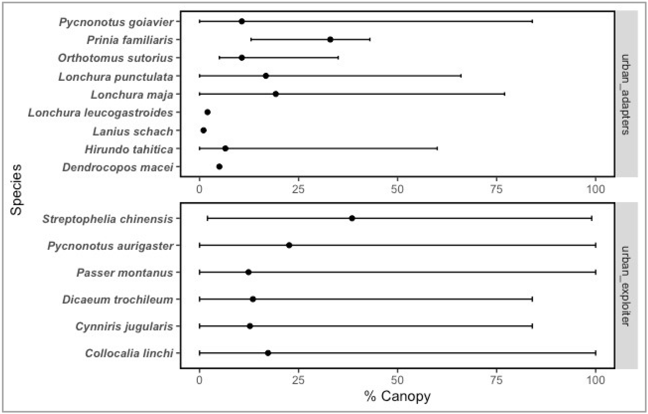
We predicted suitable habitats for the observed bird species with a focus on urban adapters and urban exploiters within our area of interest using MaxEnt [33]. The MaxEnt model, as one of the species distribution models (SDMs) is widely acknowledged to yield appropriate results in estimating species distribution or creating habitat suitability maps using presence-only data [34]. The output was based on the Relative Occurrence Rate (ROR) in a cell raster which describes the relative probability of the species modeled [34]. We applied environmental predictors composed of landscape greenness, temperature, elevation [35], distance to water, distance to green patches (green space), and land function to explore the bird distribution networks in the area (Table 1). The Normalized Difference Vegetation Index (NDVI) was used for the landscape greenness [36]. The Land Functions were classified into nine classes following the Depok City Detailed Spatial Planning Documents or RDTR (Rencana Detail Tata Ruang) 2018 (https://gistaru.atrbpn.go.id/rdtrinteraktif/ (accessed on 24 February 2022)). Each class represented a different urban zone within Depok City (Table 2). However, MaxEnt is often subjected to bias in occurrence data. Thus, to reduce bias due to presence-only data and the lack of absence data, we created a buffer of occurrence species location as a background data selection to the model [37]. We selected six environmental predictors based on our knowledge of the research area and local context that may explain the suitable habitat for the two groups (urban adapters and urban exploiters) (Table 1). The multicollinearity from variables was checked using Pearson’s correlation coefficient and variance inflation factors (VIF) which yielded close to 0.50 and less than 5 VIF values. Maps of the environmental predictors of the study areas are presented in Figure 2.
Due to the relatively small study area and the need for high-resolution data, we did not include a bioclimatic variable in our environmental predictors as it gives minimum information on the site. However, we acknowledged the importance of climatic conditions to the SDM [38]. Therefore, we used the land surface temperature derived using Google Earth Engine [39] to compensate for our data input shortcomings. We then allocated 25% of the recorded occurrence data of each group (urban exploiters and urban adapters) to test the reliability of the data with 15 iterations for each species group and estimate the AUC Area Under Curve (AUC) from the Receiver Operating Characteristic (ROC) curve.

3. Results

In total, we recorded 15 bird species, with Eurasian tree sparrows (Passer montanus) and cave swiftlets (Collocalia linchi) being the most common species in all three habitat types (Figure 3 and Figure 4). These two birds were mainly recorded on the roadside, followed by green spaces and residential areas based on encounter rates. Most of the birds were recorded in residential areas (14 species), followed by the roadside (10 species) and green spaces (9 species) (Table 3). Our data also suggests that there were six bird species considered urban exploiters and nine species considered urban adapters. There were no urban avoiders recorded during the survey (Table 4). Eurasian tree sparrows and cave swiftlets are urban exploiters who build nests in houses.
We found that the three habitat types surveyed (green spaces, residential, roadside) yielded mixed results on the bird species richness and the canopy cover of the area. Green spaces tended to have the densest canopy cover. There were also differences in the dominant vegetation. Home gardens in residential areas tended to have edible fruiting trees (Table 3).
Some species were not recorded in green spaces or roadside. Species such as Dendrocopos macei, Lanius schach, Lonchura leucogastroides, Orthotomus sutorius, and Streptophelia chinensis were never recorded on the roadside, while in the urban green spaces, we did not record Dendrocopos macei, Lanius schach, Lonchura leucogastroides, Lonchura maja, Orthotomus sutorius, and Prinia familiaris (Table 4). Species with low to no encounter rates within residential areas were composed of Lonchura punctulata, Lonchura leucogastroides, and Lanius schach (Table 4).
We found high bird species richness in residential areas, which recorded all species except the scaly-breasted munia (Lonchura punctulata) as likely recorded birds in green spaces and roadsides. On the contrary, these areas yielded fewer observed species within various canopies, from open canopy (0%) to closed canopy coverage (100%). For example, on the roadside, Passer montanus were recorded in areas with open canopy, whereas in residential and green open spaces, this species might have occurred in higher canopy coverage (Figure 3). The Collocalia linchi, was similarly found in high abundance in all three habitats as the species is an aerial insectivore.
The MaxEnt analysis provided predictions on the suitability of the urban adaptors and urban exploiters to their given areas. Urban exploiters were more suited to the urbanized part of the research area than the urban adapters in the west, where the offices and central business districts were located. Moreover, the residential area in the south was largely suited to urban exploiters. These results suggest that urban exploiters were likely to have higher matches in the study area than urban adapters. There were more considerable differences around larger roads (local roads) and tolls between urban exploiters and urban adapters (Figure 4).
The ROC curve for the two models gave AUC values of 0.721 (SD = 0.044) for urban adapters and 0.727 (SD = 0.037) for urban exploiters, which showed that the overall performance of the two models was better than random estimations [40] (Figure 5). The most critical environmental predictor for both urban adapters and urban exploiters was the distance to perennial water. Land function appeared as the second contributing variable for urban adapters, followed by distance to patches. In contrast, the second contributing variable for urban exploiters was the distance to patches, followed by land function. The least contributing predictors for both groups were landscape greenness, elevation, and temperature (Table 5).
With the response of the two bird groups to land function (Figure 6), it was shown that the probability of suitability increased with the roadside, high-density settlements, green open space, and industrial/warehousing, with the roadside giving higher feedback to the model. The model results were in line with the survey locations. Compared to urban exploiters, urban adapters tended to avoid office areas, river buffer/catchments, public facilities, and agricultural/tourism areas (Figure 6).

4. Discussion

4.1. Urban Bird Community

Depok can be considered as a suburb in the first ring of Jakarta [41]. However, the proportion of green areas is low, and this was illustrated by the bird community. Our results were similar to other studies in urban environments where urban exploiters showed higher affinities to highly urbanized areas and urban adapters were present in a lower abundance [12,32]. The most common birds in the three subdistricts in Depok, such as the Eurasian tree sparrows and cave swiftlets, were urban exploiters that could exploit man-made habitats such as buildings and houses to build their nests [30,42]. They were also present in similar abundance in the three habitat types. Other urban exploiters such as the sooty-headed bulbuls (Pycnonotus aurigaster), olive-backed sunbirds (Cynniris jugularis), scarlet-headed flowerpecker (Dicaeum trochileum), and spotted dove (Spilophelia chinensis) were also recorded inhabiting home gardens in residential areas.
Many urban adapters are foliage granivores, foliage insectivores, and foliage frugivores/insectivores. For urban adapters, vegetation, particularly in home gardens of residential areas, is essential for foraging sites and food resources, even though there are ornamental and exotic plants [15].
Insectivores usually favor urban settings, particularly ground foraging insectivores, followed by granivores, but these are less favored by frugivores [43,44]. The frugivores recorded were represented by bulbuls which were facultative frugivores such as the sooty-headed bulbuls and the yellow-vented bulbuls. These birds feed primarily on fruits but occasionally on nectar and insects [45]. Their distributions may be related to the presence of fruiting trees in home gardens [15], and species richness is related to vegetation [4]. In the urban areas, the built-in areas were usually favored by non-native bird species. The complexity of vegetation contributes to urban species richness [22]. Home gardens were typically dominated by fruiting trees such as rambutan (Nephelium lappaceum) or jackfruit (Artocarpus heterophylla). At the same time, the green spaces were likely planted with dense canopy trees such as Swietenia mahagoni for the resulting cooling effect of the urban areas [46].
Almost all species of urban adapters and exploiters were present in the residential areas except the scaly-breasted munia. The scaly-breasted munia is a granivore that eats seeds and grains, as well as insects, and was found on the roadside and in green spaces [47,48]. They may build communal nests in fig trees along the roadside [48], suggesting that roadsides provide a bird habitat. According to the Ministry of Public Works regulation (Peraturan Menteri PU No. 05/PRT/M/2012), trees planted on the roadside should follow particular requirements such as the ecological needs of the plants (climate, soil, sunlight, and drainage), shape, and function. However, the local roadsides in the three subdistricts studied were composed of Muntingia calabura and Polyalthia longifolia, a pioneer tree commonly found on the roadside of Southeast Asian streets [49,50,51]. Jamaica cherry (Muntingia calabura) is a non-native and wildlife-cultivated tree whose fruits are favored by birds [52]. Polyalthia longifolia is known to have a high level of ascorbic acid which confers a tolerance to air pollution [53,54].
Insectivores and carnivores were groups adversely affected by urbanization [15]. During the survey, we did not record any raptors as they may be apt to suburban areas. This is similar to a previous study on Jakarta and its satellite cities [11]. However, several species such as the little swift (Apus affinis), plaintive cuckoo (Cacomanthis merulinus), and ruby-cheeked sunbird (Chalcoparia singalensis) were not recorded in our survey.
The UI urban forest was the largest and closest urban green area of the study areas, which spanned 320 ha comprising both faculty buildings and urban forests. The areas were planted with diverse trees, including figs, which were mostly preferred by birds [23,55]. Frugivores, insectivores, and nectarivores were observed foraging on the fig trees within this campus [55]. Studies from 1989 to 2014 recorded at least 26 bird species [56]. Some of the dominant birds observed were similar to this study, such as the sooty-headed bulbuls and the cave swiftlet. The Eurasian tree sparrow did not count as common during 1989–2014. Avoiders were still recorded in urban forests [57]. The close distance of some residential areas to the campus showed a bit of variety in the urban adapters observed, such as the fulvous-breasted woodpecker (Dendrocopos macei) and long-tailed shrike (Lanius schach), which were regularly sighted on the campus [56]. Their presence was highly correlated to the presence of old-mature trees such as those in the UI urban forest [55,58,59]. While providing socio-economic benefits to the surrounding people, the urban forest on the UI campus provides ecological benefits such as wildlife habitats, soil conservation, and enhancing biodiversity [60]. Taking a deeper habitat island approach, fragmented urban habitats result in poorer bird diversity in small patches but larger bird and habitat diversity in large patches such as the UI urban forest. Being closer to large patches can significantly increase bird species richness [61].

4.2. Predicted Distributions of Urban Adapters and Urban Exploiters

Urban adapters and urban exploiters are two groups that make up the main bird communities in urban areas, including Depok. As expected, in our study the distributions of urban exploiters were much larger than the urban adapters as they have broader dietary niches, which were provided in home gardens in residential areas [4,62]. However, the small coverage of the study area should be considered when applying this to other sites.
Several studies have revealed different spatial distribution patterns such as the size of green areas or patches and the allocation of green areas [16,63]. The three subdistricts in the outskirts of Jakarta have shown particular environmental predictors for bird distributions. In Depok, while there are restricted habitats for birds in the urban areas, water sources are potentially crucial for the birds in these areas. Water bodies support diverse plant structures and diversity, providing foraging habitat and food resources for birds. Water bodies, therefore, maintain bird diversity and significantly increase species richness [64,65]. There are at least two riparian zones in Depok, i.e., Pesanggrahan and Ciliwung, and several small streams and lakes. The two riparian zones showed particular tree community structures [66]. For example, native vegetation such as trees from the Moraceae family (Ficus benjamina, F. racemosa, F. septica, Artocarpus heterophyllus) was still present in some areas of the Ciliwung riparian zones [66]. Ficus benjamina is an important food resource for birds in urban habitats [55,67]. In addition, birds may use water sources from free water in water bodies such as lakes, rivers, and streams; preformed water contained in food sources such as fruits and nectars; and metabolic water produced from their oxidation [68]. Water bodies provide safe drinking water and bathing resources for terrestrial birds [69].
Land function was the second important predictor for urban adapters, while the distance to patches was the second predictor for urban exploiters. Roadside, high-density settlements, and green open space areas are land function predictors for urban adapters. Urban adapters avoid areas such as business areas and office areas which usually have less vegetation. Green spaces and roadsides in Depok are likely denser in tree cover [70] and the areas close to green spaces can significantly increase bird species richness due to the presence of natural vegetation [63]. Urban birds still showed relationships to vegetation, indicating the need for cover, nests, and foraging habitats. Vegetation, however, may not be directly related to aerial insectivores such as cave swiftlets, but insects use tree canopies as their food source [71]. Land characteristics such as high buildings may have a more significant advantage for their breeding success as they provide nesting sites [32,72]. Cave swiftlets are commonly seen to build small bracket-shaped nests on the vertical walls of houses using the secretions from their salivary glands [73,74].
Residential habitats are promising for the support of bird diversity in urban areas. Many houses in Depok are usually accompanied by home gardens planted with non-native vegetation, including fruiting trees, flowering plants, herbs, and leafy greens, indicating that vegetation may be clustered, fragmented, and spaced-out [8,75]. Unsurprisingly, we did not record avoiders that are usually correlated to native vegetation. Similar situations were also observed in Bogor, in which the same urban exploiter species were recorded in residential areas [76]. However, both urban adapters and urban exploiters thrive in residential areas suggesting that home gardens provide additional habitats when green spaces are unavailable.
Although the green spaces in Jakarta tend to be doubled [42,77], the proportion of the green spaces in Jakarta is still predicted to be lower compared to Kuala Lumpur and Manila in 2030 [77]. At least in the three subdistricts, there are not many green spaces available, and the existing green spaces are usually small areas for community gatherings, which are too small to support bird diversity.

4.3. Improvement of Urban Ecosystem

This study suggested that community gardens were important for supporting green spaces in urban areas [78,79,80]. Indonesian community gardens (or the so-called pekarangan) are usually small-holder agroforestry systems promoting carbon stocks [79], which can be adapted for urban ecosystems. Connectivity is the main problem in increasing the urban bird habitat network. Home gardens are promising for acting as a connectivity element for bird habitats [61]. Increasing green areas and improving landscape connectivity are two crucial steps in urban vegetation planning [21]. Both structural (i.e., distance between patches and corridor width) and functional connectivity (specific needs of target groups) should be included in pertaining the landscape connectivity [81], while also taking into account increasing water sources [64].
The pandemic situation has increased peoples’ interest in gardening, which can improve food and nutritional security [82,83], suggesting that the limited land in urban areas does not necessarily reduce the importance of home gardens in providing ecosystem services. Such individual movements in parallel can also support better habitats for wildlife while increasing ecosystem services.

5. Conclusions

This study in three districts in Depok, Jawa Barat, covering green spaces, residential areas, and roads recorded two groups of birds, urban exploiters, and urban adapters. The urban exploiters were likely to have more extensive ranges than the urban adapters, particularly in the residential areas. Water sources predicted the distributions of both urban adapters and exploiters. At the same time, the land function was the second significant predictor for urban adapters, and landscape greenness was the predictor for urban exploiters. These predictors should be considered in urban vegetation planning, such as creating bird-friendly habitats that provide water sources and vegetation. Home gardens planted with fruiting trees and other plants can provide additional support to green spaces, which may expand the potential habitats for urban birds.

Author Contributions

Nurul L. Winarni and Mega Atria; methodology, Nurul L. Winarni, Mega Atria and Afiatry Putrika; field data collection, Nurul L. Winarni, Bhisma G. Anugra, Nabilla Nuril Kaunain and Shania Anisafitri; spatial data collection, Habiburrachman A. H. Fuad; analysis, Nurul L. Winarni and Habiburrachman A. H. Fuad; writing, Nurul L. Winarni and Habiburrachman A. H. Fuad. All authors have read and agreed to the published version of the manuscript.

Funding

This research was funded by Universitas Indonesia funding Hibah PUTI Q3 (NKB-1967/UN2.RST/HKP.05.00/2020).

Institutional Review Board Statement

Not applicable.

Informed Consent Statement

Not applicable.

Data Availability Statement

Not applicable.

Acknowledgments

This study was funded through the Universitas Indonesia funding Hibah PUTI Q3 (NKB-1967/UN2.RST/HKP.05.00/2020) for NLW. We thank all the people who contributed to this survey. We also thank our anonymous reviewers.

Conflicts of Interest

The authors declare no conflict of interest. The funders had no role in the design of the study; in the collection, analyses, or interpretation of data; in the writing of the manuscript, or in the decision to publish the results.

References

  1. Setiawan, H.; Mathieu, R.; Thompson-Fawcett, M. Assessing the Applicability of the V–I–S Model to Map Urban Land Use in the Developing World: Case Study of Yogyakarta, Indonesia. Comput. Environ. Urban Syst. 2006, 30, 503–522. [Google Scholar] [CrossRef]
  2. Lepczyk, C.A.; Sorte, F.A.L.; Aronson, M.F.; Goddard, M.A.; MacGregor-Fors, I.; Nilon, C.H.; Warren, P.S. Global Patterns and Drivers of Urban Bird Diversity. In Ecology and Conservation of Birds in Urban Environments; Springer: Berlin/Heidelberg, Germany, 2017; pp. 13–33. [Google Scholar]
  3. Zain, A.F.M.; Permatasari, P.A.; Ainy, C.N.; Destriana, N.; Mulyati, D.F.; Edi, S. The Detection of Urban Open Space at Jakarta, Bogor, Depok, and Tangerang—Indonesia by Using Remote Sensing Technique for Urban Ecology Analysis. Procedia Environ. Sci. 2015, 24, 87–94. [Google Scholar] [CrossRef]
  4. McKinney, M.L. Urbanization, Biodiversity, and Conservation: The Impacts of Urbanization on Native Species Are Poorly Studied, but Educating a Highly Urbanized Human Population about These Impacts Can Greatly Improve Species Conservation in All Ecosystems. Bioscience 2002, 52, 883–890. [Google Scholar] [CrossRef]
  5. Whitney, G.G. A Quantitative Analysis of the Flora and Plant Communities of a Representative Midwestern US Town. Urban Ecol. 1985, 9, 143–160. [Google Scholar] [CrossRef]
  6. Blair, R.B. Land Use and Avian Species Diversity Along an Urban Gradient. Ecol. Appl. 1996, 6, 506–519. [Google Scholar] [CrossRef]
  7. Lancaster, R.K.; Rees, W.E. Bird Communities and the Structure of Urban Habitats. Can. J. Zool. 1979, 57, 2358–2368. [Google Scholar] [CrossRef]
  8. Chace, J.F.; Walsh, J.J. Urban Effects on Native Avifauna: A Review. Landsc. Urban Plan. 2006, 74, 46–69. [Google Scholar] [CrossRef]
  9. Wenny, D.G.; Devault, T.L.; Johnson, M.D.; Kelly, D.; Sekercioglu, C.H.; Tomback, D.F.; Whelan, C.J. The Need to Quantify Ecosystem Services Provided by Birds. Auk 2011, 128, 1–14. [Google Scholar] [CrossRef]
  10. Cox, D.T.; Hudson, H.L.; Plummer, K.E.; Siriwardena, G.M.; Anderson, K.; Hancock, S.; Devine-Wright, P.; Gaston, K.J. Covariation in Urban Birds Providing Cultural Services or Disservices and People. J. Appl. Ecol. 2018, 55, 2308–2319. [Google Scholar] [CrossRef]
  11. Mardiastuti, A.; Mulyani, Y.A.; Rinaldi, D.; Rumblat, W.; Dewi, L.K.; Kaban, A.; Sastranegara, H. Synurbic Avian Species in Greater Jakarta Area, Indonesia. IOP Conf. Ser. Earth Environ. Sci. 2020, 457, 012001. [Google Scholar] [CrossRef]
  12. Kark, S.; Iwaniuk, A.; Schalimtzek, A.; Banker, E. Living in the City: Can Anyone Become an ‘urban Exploiter’? J. Biogeogr. 2007, 34, 638–651. [Google Scholar] [CrossRef]
  13. Seto, K.C.; Fleishman, E.; Fay, J.P.; Betrus, C.J. Linking Spatial Patterns of Bird and Butterfly Species Richness with Landsat Tm Derived Ndvi. Int. J. Remote Sens. 2004, 25, 4309–4324. [Google Scholar] [CrossRef]
  14. Tursilowati, L.; Tetuko Sri Sumantyo, J.; Kuze, H.; Adiningsih, E.S. Relationship between Urban Heat Island Phenomenon and Land Use/Land Cover Changes in Jakarta-Indonesia. J. Emerg. Trends Eng. Appl. Sci. 2012, 3, 645–653. [Google Scholar]
  15. Lim, H.C.; Sodhi, N.S. Responses of Avian Guilds to Urbanisation in a Tropical City. Landsc. Urban Plan. 2004, 66, 199–215. [Google Scholar] [CrossRef]
  16. Geschke, A.; James, S.; Bennett, A.F.; Nimmo, D.G. Compact Cities or Sprawling Suburbs? Optimising the Distribution of People in Cities to Maximise Species Diversity. J. Appl. Ecol. 2018, 55, 2320–2331. [Google Scholar] [CrossRef]
  17. Conole, L.E.; Kirkpatrick, J.B. Functional and Spatial Differentiation of Urban Bird Assemblages at the Landscape Scale. Landsc. Urban Plan. 2011, 100, 11–23. [Google Scholar] [CrossRef]
  18. Szulkin, M.; Garroway, C.J.; Corsini, M.; Kotarba, A.Z.; Dominoni, D.; Szulkin, M. How to Quantify Urbanization When Testing for Urban Evolution? In Urban Evolutionary Biology; Oxford University Press: Oxford, UK, 2020; pp. 13–35. [Google Scholar]
  19. Mildawani, I.; Rahman, A. Household Gardening as Preference Activities to Cupport Community Resilience during Pandemic COVID-19. J. Synerg. Landsc. 2021, 1, 64–79. [Google Scholar] [CrossRef]
  20. Santosa, E.; Susila, A.D.; Widodo, W.D.; Nasrullah, N.; Ruwaida, I.P.; Sari, R. Exploring Fruit Tree Species as Multifunctional Greenery: A Case of Its Distribution in Indonesian Cities. Sustainability 2021, 13, 7835. [Google Scholar] [CrossRef]
  21. Shanahan, D.F.; Miller, C.; Possingham, H.P.; Fuller, R.A. The Influence of Patch Area and Connectivity on Avian Communities in Urban Revegetation. Biol. Conserv. 2011, 144, 722–729. [Google Scholar] [CrossRef]
  22. Kang, W.; Minor, E.S.; Park, C.-R.; Lee, D. Effects of Habitat Structure, Human Disturbance, and Habitat Connectivity on Urban Forest Bird Communities. Urban Ecosyst. 2015, 18, 857–870. [Google Scholar] [CrossRef]
  23. Pradipta, E.; Kholis, N.; Lestari, F.; Lestari, R.; Bowolaksono, A. Reassessing the Benefits and Costs of Universitas Indonesia’s Urban Forest Zonation. IOP Conf. Ser. Mater. Sci. Eng. 2019, 546, 022015. [Google Scholar] [CrossRef]
  24. Setiowati, R.; Hasibuan, H.S.; Koestoer, R.H.; Harmain, R. Planning for Urban Green Area and Its Importance for Sustainability: The Case of Jakarta. IOP Conf. Ser. Earth Environ. Sci. 2019, 328, 012027. [Google Scholar] [CrossRef]
  25. Bibby, C.; Burgess, N.; Hill, D.; Mustoe, S. Bird Census Technique, 2nd ed.; Academic Press: London, UK, 2000. [Google Scholar]
  26. Open Data Kit. Open Data Kit Documentation (2017); Open Data Kit: Fullerton, CA, USA, 2018. [Google Scholar]
  27. Patrignani, A.; Ochsner, T.E. Canopeo: A Powerful New Tool for Measuring Fractional Green Canopy Cover. Agron. J. 2015, 107, 2312–2320. [Google Scholar] [CrossRef]
  28. Sharma, S.; Sharma, H.P.; Chaulagain, C.; Katuwal, H.B.; Belant, J.L. Estimating Occupancy of Chinese Pangolin (Manis Pentadactyla) in a Protected and Non-Protected Area of Nepal. Ecol. Evol. 2020, 10, 4303–4313. [Google Scholar] [CrossRef] [PubMed]
  29. Salman, I.N.; Blaustein, L. Vegetation Cover Drives Arthropod Communities in Mediterranean/Subtropical Green Roof Habitats. Sustainability 2018, 10, 4209. [Google Scholar] [CrossRef]
  30. Winarni, N.L.; Anugra, B.G.; Anisafitri, S.; Kaunain, N.N.; Pradana, D.H. Fieldwork during Pandemic: Backyard Bird Survey and Making Student’s Biological Field Practice Works. Biodiversitas J. Biol. Divers. 2021, 22, 4. [Google Scholar] [CrossRef]
  31. Lambert, F.R.; Collar, N.J. The Future for Sundaic Lowland Forest Birds: Long-Term Effects of Commercial Logging and Fragmentation. Forktail 2002, 18, 127–146. [Google Scholar]
  32. Cristaldi, M.A.; Giraudo, A.R.; Arzamendia, V.; Bellini, G.P.; Claus, J. Urbanization Impacts on the Trophic Guild Composition of Bird Communities. J. Nat. Hist. 2017, 51, 2385–2404. [Google Scholar] [CrossRef]
  33. Phillips, S.J.; Anderson, R.P.; Dudík, M.; Schapire, R.E.; Blair, M.E. Opening the Black Box: An Open-Source Release of Maxent. Ecography 2017, 40, 887–893. [Google Scholar] [CrossRef]
  34. Merow, C.; Smith, M.J.; Silander Jr, J.A. A Practical Guide to MaxEnt for Modeling Species’ Distributions: What It Does, and Why Inputs and Settings Matter. Ecography 2013, 36, 1058–1069. [Google Scholar] [CrossRef]
  35. Hof, A.R.; Jansson, R.; Nilsson, C. The Usefulness of Elevation as a Predictor Variable in Species Distribution Modelling. Ecol. Model. 2012, 246, 86–90. [Google Scholar] [CrossRef]
  36. Nieto, S.; Flombaum, P.; Garbulsky, M.F. Can Temporal and Spatial NDVI Predict Regional Bird-Species Richness? Glob. Ecol. Conserv. 2015, 3, 729–735. [Google Scholar] [CrossRef] [Green Version]
  37. Coxen, C.L.; Frey, J.K.; Carleton, S.A.; Collins, D.P. Species Distribution Models for a Migratory Bird Based on Citizen Science and Satellite Tracking Data. Glob. Ecol. Conserv. 2017, 11, 298–311. [Google Scholar] [CrossRef]
  38. Booth, T.H. Why Understanding the Pioneering and Continuing Contributions of BIOCLIM to Species Distribution Modelling Is Important. Austral Ecol. 2018, 43, 852–860. [Google Scholar] [CrossRef]
  39. Ermida, S.L.; Soares, P.; Mantas, V.; Göttsche, F.-M.; Trigo, I.F. Google Earth Engine Open-Source Code for Land Surface Temperature Estimation from the Landsat Series. Remote Sens. 2020, 12, 1471. [Google Scholar] [CrossRef]
  40. Çoban, H.O.; Örücü, Ö.K.; Arslan, E.S. MaxEnt Modeling for Predicting the Current and Future Potential Geographical Distribution of Quercus Libani Olivier. Sustainability 2020, 12, 2671. [Google Scholar] [CrossRef]
  41. Hasibuan, H.S.; Soemardi, T.P.; Koestoer, R.; Moersidik, S. The Role of Transit Oriented Development in Constructing Urban Environment Sustainability, the Case of Jabodetabek, Indonesia. Procedia Environ. Sci. 2014, 20, 622–631. [Google Scholar] [CrossRef]
  42. Nor, A.N.M.; Corstanje, R.; Harris, J.A.; Grafius, D.R.; Siriwardena, G.M. Ecological Connectivity Networks in Rapidly Expanding Cities. Heliyon 2017, 3, e00325. [Google Scholar] [CrossRef]
  43. Carbó-Ramírez, P.; Zuria, I. The Value of Small Urban Greenspaces for Birds in a Mexican City. Landsc. Urban Plan. 2011, 100, 213–222. [Google Scholar] [CrossRef]
  44. van Heezik, Y.; Smyth, A.; Mathieu, R. Diversity of Native and Exotic Birds across an Urban Gradient in a New Zealand City. Landsc. Urban Plan. 2008, 87, 223–232. [Google Scholar] [CrossRef]
  45. MacKinnon, J.; Phillipps, K. A Field Guide to the Birds of Borneo, Sumatra, Java, and Bali; Oxford University Press: New York, NY, USA, 1993. [Google Scholar]
  46. Rahman, M.A.; Moser, A.; Rötzer, T.; Pauleit, S. Comparing the Transpirational and Shading Effects of Two Contrasting Urban Tree Species. Urban Ecosyst. 2019, 22, 683–697. [Google Scholar] [CrossRef]
  47. Yap, C.A.; Sodhi, N.S. Southeast Asian Invasive Birds: Ecology, Impact and Management. Ornithol. Sci. 2004, 3, 57–67. [Google Scholar] [CrossRef]
  48. Zhou, B.; Liu, J.; Liang, W. Breeding in a Noisy World: Attraction to Urban Arterial Roads and Preference for Nest-Sites by the Scaly-Breasted Munia (Lonchura Punctulata). Glob. Ecol. Conserv. 2020, 22, e00987. [Google Scholar] [CrossRef]
  49. Fleming, T.H.; Williams, C.F.; Bonaccorso, F.J.; Herbst, L.H. Phenology, Seed Dispersal, and Colonization in Muntingia Calabura, a Neotropical Pioneer Tree. Am. J. Bot. 1985, 72, 383–391. [Google Scholar] [CrossRef]
  50. Sufian, A.S.; Ramasamy, K.; Ahmat, N.; Zakaria, Z.A.; Yusof, M.I.M. Isolation and Identification of Antibacterial and Cytotoxic Compounds from the Leaves of Muntingia Calabura L. J. Ethnopharmacol. 2013, 146, 198–204. [Google Scholar] [CrossRef]
  51. Sarwadi, A.; Irwan, S.N.R.; Utami, R.N.; Raya, A.B. Study on Roadside Greenery in Yogyakarta City towards Development of Productive Urban Landscape. IOP Conf. Ser. Earth Environ. Sci. 2019, 361, 012008. [Google Scholar] [CrossRef]
  52. Hawkeswood, T.J.; Sommung, B. Pollination of Muntingia Calabura L. (Muntingiaceae) by Native Bees in Bangkok, Thailand 2016. Calodema 2016, 421, 1–6. [Google Scholar]
  53. Yadav, R.; Pandey, P. Assessment of Air Pollution Tolerance Index (APTI) and Anticipated Performance Index (API) of Roadside Plants for the Development of Greenbelt in Urban Area of Bathinda City, Punjab, India. Bull. Environ. Contam. Toxicol. 2020, 105, 906–914. [Google Scholar] [CrossRef]
  54. Kazi, E.; Shaikh, Y.I.; Tikle, S.; Shaikh, G.B.V.S.; Kulkarni, S.; Dhulap, V.P. Effect of Air Pollutants on Urban Roadside Trees in Shivajinagar & Pashan Area, Pune City. ES Food Agrofor. 2021, 5, 29–37. [Google Scholar]
  55. Pradana, D.H.; Mardiastuti, A.; Yasman, Y. Utilization of Ficus Benjamina by Birds at Urban Habitat in Depok. Bioma Berk. Ilm. Biol. 2019, 20, 75–78. [Google Scholar] [CrossRef]
  56. Putri, F.A.; Basukriadi, A.; Pradana, D.H. Study of the Bird Community in Rubber Plantations at Universitas Indonesia, Depok. AIP Conf. Proc. 2020, 2242, 050020. [Google Scholar]
  57. Nugraha, B.P. Efek Gradien Urbanisasi Habitat Terhadap Komunitas Burung Di Kampus Universitas Indonesia, Depok, Jawa Barat; Skripsi, Universitas Indonesia: Depok, Indonesia, 2014. [Google Scholar]
  58. Melletti, M.; Penteriani, V. Nesting and Feeding Tree Selection in the Endangered White-Backed Woodpecker, Dendrocopos Leucotos Lilfordi. Wilson J. Ornithol. 2003, 115, 299–306. [Google Scholar] [CrossRef]
  59. Nurjaman, D.; Husodo, T.; Megantara, E.N.; Hadikusumah, H.Y.; Wulandari, I. Relationship of Bird Diversity and Plant Composition Inside The Area Campus Green Space of Universitas Padjadjaran Jatinangor, Sumedang West Java. Biost. J. Biol. Biol. Educ. 2018, 10, 500–509. [Google Scholar] [CrossRef]
  60. Dwyer, J.F.; McPherson, E.G.; Schroeder, H.W.; Rowntree, R.A. Assessing the Benefits and Costs of the Urban Forest. J. Arboric. 1992, 18, 227. [Google Scholar] [CrossRef]
  61. Fernandez-Juricic, E.; Jokimäki, J. A Habitat Island Approach to Conserving Birds in Urban Landscapes: Case Studies from Southern and Northern Europe. Biodivers. Conserv. 2001, 10, 2023–2043. [Google Scholar] [CrossRef]
  62. Palacio, F.X. Urban Exploiters Have Broader Dietary Niches than Urban Avoiders. Ibis 2020, 162, 42–49. [Google Scholar] [CrossRef]
  63. Ikin, K.; Knight, E.; Lindenmayer, D.B.; Fischer, J.; Manning, A.D. The Influence of Native versus Exotic Streetscape Vegetation on the Spatial Distribution of Birds in Suburbs and Reserves. Divers. Distrib. 2013, 19, 294–306. [Google Scholar] [CrossRef]
  64. Xie, S.; Marzluff, J.M.; Su, Y.; Wang, Y.; Meng, N.; Wu, T.; Gong, C.; Lu, F.; Xian, C.; Zhang, Y. The Role of Urban Waterbodies in Maintaining Bird Species Diversity within Built Area of Beijing. Sci. Total Environ. 2021, 806, 150430. [Google Scholar] [CrossRef]
  65. Ferenc, M.; Sedláček, O.; Fuchs, R. How to Improve Urban Greenspace for Woodland Birds: Site and Local-Scale Determinants of Bird Species Richness. Urban Ecosyst. 2014, 17, 625–640. [Google Scholar] [CrossRef]
  66. Pratiwi, A.D.; Wardhana, W.; Putrika, A. Community Structure of Tree at Three Location Points of Ciliwung Riparian Zone in Depok–South Jakarta. Phys. Conf. Ser. 2021, 1725, 012036. [Google Scholar] [CrossRef]
  67. Mardiastuti, A.; Mulyani, Y.A.; Kusrini, M.D. Bird Visit to Ficus Benjamina in Two Urbanization Gradients in the Tropics. IOP Conf. Ser. Earth Environ. Sci. 2021, 948, 012061. [Google Scholar] [CrossRef]
  68. Bartholomew, G.A.; Cade, T.J. The Water Economy of Land Birds. Auk 1963, 80, 504–539. [Google Scholar] [CrossRef]
  69. Zivanovic, A.J.; Luck, G.W. Social and Environmental Factors Drive Variation in Plant and Bird Communities across Urban Greenspace in Sydney, Australia. J. Environ. Manag. 2016, 169, 210–222. [Google Scholar] [CrossRef] [PubMed]
  70. Leveau, L.M.; Isla, F.I.; Bellocq, M.I. Predicting the Seasonal Dynamics of Bird Communities along an Urban-Rural Gradient Using NDVI. Landsc. Urban Plan. 2018, 177, 103–113. [Google Scholar] [CrossRef]
  71. Rahman, S.F.S.A.; Nor, H.M.; Burhanuddin, M. Diversity of the Insects in the Diet of Edible Nest Swiftlets in Oil Palm Plantations. J Biodivers. Env. Sci 2016, 8, 39–48. [Google Scholar]
  72. Sullivan, S.M.P.; Corra, J.W.; Hayes, J.T. Urbanization Mediates the Effects of Water Quality and Climate on a Model Aerial Insectivorous Bird. Ecol. Monogr. 2021, 91, e01442. [Google Scholar] [CrossRef]
  73. Thorburn, C. The Edible Birds’ Nest Boom in Indonesia and South-East Asia: A Nested Political Ecology. Food Cult. Soc. 2014, 17, 535–553. [Google Scholar] [CrossRef]
  74. Lack, D. A Review of the Genera and Nesting Habits of Swifts. Auk 1956, 73, 1–32. [Google Scholar] [CrossRef]
  75. Debataraja, I.B.; Pradana, D.H.; Winarni, N.L. The Impact of Landuse and the Relationship between NDVI on the Bird Species Richness in Sukmajaya District, Depok. IOP Conf. Ser. Earth Environ. Sci. 2021, 846, 012004. [Google Scholar] [CrossRef]
  76. Mardiastuti, A.; Putra, M.S.K.; Mulyani, Y.A. Bird Diversity Patterns along Urbanization Gradients: Some Recommendations for Landscape Planner. IOP Conf. Ser. Earth Environ. Sci. 2020, 556, 012012. [Google Scholar] [CrossRef]
  77. Nor, A.N.M.; Corstanje, R.; Harris, J.A.; Brewer, T. Impact of Rapid Urban Expansion on Green Space Structure. Ecol. Indic. 2017, 81, 274–284. [Google Scholar] [CrossRef]
  78. Doody, B.J.; Sullivan, J.J.; Meurk, C.D.; Stewart, G.H.; Perkins, H.C. Urban Realities: The Contribution of Residential Gardens to the Conservation of Urban Forest Remnants. Biodivers. Conserv. 2010, 19, 1385–1400. [Google Scholar] [CrossRef]
  79. Arifin, H.; Nakagoshi, N. Landscape Ecology and Urban Biodiversity in Tropical Indonesian Cities. Landsc. Ecol. Eng. 2011, 7, 33–43. [Google Scholar] [CrossRef]
  80. Middle, I.; Dzidic, P.; Buckley, A.; Bennett, D.; Tye, M.; Jones, R. Integrating Community Gardens into Public Parks: An Innovative Approach for Providing Ecosystem Services in Urban Areas. Urban For. Urban Green. 2014, 13, 638–645. [Google Scholar]
  81. Grafius, D.R.; Corstanje, R.; Siriwardena, G.M.; Plummer, K.E.; Harris, J.A. A Bird’s Eye View: Using Circuit Theory to Study Urban Landscape Connectivity for Birds. Landsc. Ecol. 2017, 32, 1771–1787. [Google Scholar] [CrossRef] [PubMed]
  82. Lal, R. Home Gardening and Urban Agriculture for Advancing Food and Nutritional Security in Response to the COVID-19 Pandemic. Food Secur. 2020, 12, 871–876. [Google Scholar] [CrossRef]
  83. Montefrio, M.J.F. Interrogating the “Productive” Home Gardener in a Time of Pandemic Lockdown in the Philippines. Food Foodways 2020, 28, 216–225. [Google Scholar] [CrossRef]
Figure 1. Bird survey locations were spread around the Universitas Indonesia campus, Depok, Indonesia.
Ijgi 11 00474 g001
Figure 2. Map of environmental predictors with (A) landscape greenness, (B) land function with land function zone (1. water bodies, 2. roads, 3. business districts and industry, 4. offices and small businesses, 5. buffer area, 6. settlement and housing, 7. public service area, 8. agriculture and tourism, and 9. green open space), (C) temperature (°K) in the survey area, (D) distance to patches, (E) distance to water, and (F) elevation data within the survey area.
Ijgi 11 00474 g002
Figure 3. Observed canopy coverage per bird based on urban tolerance classification.
Ijgi 11 00474 g003
Figure 4. Habitat suitability of (A) urban adapters, (B) urban exploiters, (C) different values between urban adapters and urban exploiters to emphasize the greater range/niche/distribution of urban exploiter species in urban areas.
Ijgi 11 00474 g004
Figure 5. The ROC curve of urban adapter (left), and urban exploiter species (right).
Ijgi 11 00474 g005
Figure 6. Response of urban adapters to land function variable (left), the response of urban exploiters to land function variable (right) with (1) water body, (2) roadside, (3) industrial/warehousing, (4) office area/small business, (5) river buffer/catchments, (6) high-density settlement, (7) public facilities, (8) agriculture/tourism, (9) green open spaces.
Ijgi 11 00474 g006
Table 1. Environmental predictors used in the MaxEnt modeling (all with 30 m resolutions).
Environmental PredictorDescriptionData Source and Reference
Landscape GreennessNormalized Difference Vegetation Index (NDVI) in June 2020USGS Landsat 8 processed data [36]
Land FunctionInformation was developed based on Depok City Detailed Spatial Planning Documents or RDTR (Rencana Detail Tata Ruang) 2018.Processed data were based on Detailed Spatial Planning RDTR and visually interpreted from the official website
TemperatureLand Surface Temperature of the research area in June 2020Landsat 8 processed data automated algorithm from Google Earth Engine [28]
ElevationElevation in the research areaSRTM downloaded from USGS EarthExplorer (https://earthexplorer.usgs.gov/ (accessed on 24 February 2022))
Distance to Large Green Patches (LGP)Distance to nearby green patches including urban forests, agriculture areas, and a golf course nearby the research areaIdentification of Large Green Patches (LGP) was based on NDVI > 0.6 and land function green open space area [35]
Distance to WaterDistance to water including a river and a lake inside the research area. Processed using Euclidean Distance ToolProcessed and rasterized data using Land Function data of water body.
Table 2. Description of land function categories.
CodeLand FunctionDescription
1Water BodiesThe large area of water
2RoadsConsists of networks of artery and major roads, usually accompanied by a gradient of vegetation along the road edges
3Business Districts + Industry and WarehousingIncludes all the business districts following the city’s major roads
4OfficesZoning areas representing small offices located outside business districts
5Buffer AreaA mandatory buffer zone for at least 25 m from rivers, beaches, lakes, and water sources.
6Settlement and HousingMiddle- to high-density settlements and housing within the research area
7Public Service AreaGenerally a zone of public services buildings and education services concentrated within Universitas Indonesia Area
8Agriculture and TourismUsually tourism that uses large areas such as a golf course and estate-level agriculture such as fish ponds
9Green Open SpaceGenerally a zone consisting of parks, urban forests, and cemeteries with a certain degree of vegetation/greenness planted
Table 3. Number of survey points, number of species, canopy cover, NDVI, and dominant vegetation in the three habitat types.
ResidentialGreen Open SpacesRoadside
Number of points521944
Number of bird species14910
Average canopy cover (Canopeo)17.5220.9011.13
Dominant vegetationNephelium lappaceum, Artocarpus heterophyllus, Carica papayaSwietenia mahagoni, Swietenia macrophylla, Cerbera manghasMuntingia calabura, Polyalthia longifolia, Gnetum gnemon
Table 4. Observed bird species during the survey with abundance and frequency.
SpeciesTrophic GuildHousesGreen SpacesRoadside
Abund.Freq.Abund.Freq.Abun.Freq.
Urban adapters
Dendrocopos maceibark insectivores40.06 0.00 0.00
Hirundo tahiticaaerial insectivores270.4220.29110.29
Lanius schachcarnivore/insectivore10.02 0.00 0.00
Lonchura leucogastroidesfoliage granivore10.02 0.00 0.00
Lonchura majafoliage granivore20.03 0.0010.03
Lonchura punctulatafoliage granivore 0.0010.14 0.00
Orthotomus sutoriusfoliage insectivore60.09 0.00 0.00
Prinia familiarisfoliage insectivore20.03 0.0010.03
Pycnonotus goiavierfoliage insectivore/frugivore210.3240.57250.66
Urban exploiters
Collocalia linchiaerial insectivores830.37170.39740.37
Cynniris jugularisnectarivores110.0510.0210.01
Dicaeum trochileumfoliage frugivore220.1040.09230.12
Passer montanusterrestrial granivore540.24140.32620.31
Pycnonotus aurigasterfoliage frugivore/insectivore530.2350.11400.20
Spilopelia chinensisterrestrial granivore40.0230.07 0.00
Table 5. Contribution of environmental predictor (%) to urban adapters and urban exploiters.
Environmental PredictorUrban AdapterUrban ExploiterMean (Min-Max)
Distance to perennial water (meter)3.843.30193(0–589)
Distance to large green patches (meter)18.5024.1036(0–182)
Land Function (Categorical)28.7018.00Categorical data,
settlement and housing as dominant zone
Landscape greenness (Unitless)4.306.400.5(−0.42–0.79)
Elevation (masl)5.606.5049(45–93)
Temperature (K)5.101.70 306(303–313)
Publisher’s Note: MDPI stays neutral with regard to jurisdictional claims in published maps and institutional affiliations.

